Next Issue
Volume 13, June-2
Previous Issue
Volume 13, May-2


Water, Volume 13, Issue 11 (June-1 2021) – 175 articles

Cover Story (view full-size image): 
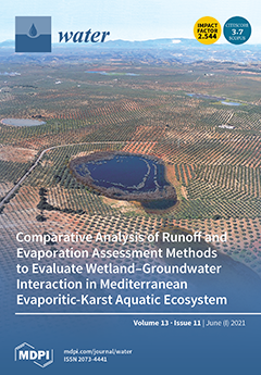
This work compares the applicability of several free-surface evaporation and runoff equations for simulating water level variations in small Mediterranean wetlands: the Jarales (centre of the picture) and Amarga wetlands, two pilot sites with an evaporite-karst genesis located in southern Spain. The results permitted specifying the water budget of both wetlands and confirming how the groundwater–surface water relationship affects their hydric dynamics. These results help to explain their hydrogeological functioning, including the origin and fate of the water, as well as to define adequate conservation and protection strategies. Picture by Juan de la Cruz Merino. View this paper
  • Issues are regarded as officially published after their release is announced to the table of contents alert mailing list.
  • You may sign up for e-mail alerts to receive table of contents of newly released issues.
  • PDF is the official format for papers published in both, html and pdf forms. To view the papers in pdf format, click on the "PDF Full-text" link, and use the free Adobe Reader to open them.
Order results
Result details
Section
Select all
Export citation of selected articles as:
24 pages, 3223 KiB  
Article
Middle Holocene Climate Oscillations Recorded in the Western Dvina Lakeland
by Agnieszka Mroczkowska, Dominik Pawłowski, Emilie Gauthier, Andrey Mazurkevich, Tomi P. Luoto, Odile Peyron, Bartosz Kotrys, Stephen J. Brooks, Larisa B. Nazarova, Liudmila Syrykh, Ekaterina V. Dolbunova, Eva Thiebaut, Mateusz Płóciennik, Olga Antczak-Orlewska and Piotr Kittel
Water 2021, 13(11), 1611; https://0-doi-org.brum.beds.ac.uk/10.3390/w13111611 - 07 Jun 2021
Cited by 6 | Viewed by 3820
Abstract
Although extensive archeological research works have been conducted in the Serteya region in recent years, the Holocene climate history in the Western Dvina Lakeland in Western Russia is still poorly understood. The Neolithic human occupation of the Serteyka lake–river system responded to climate [...] Read more.
Although extensive archeological research works have been conducted in the Serteya region in recent years, the Holocene climate history in the Western Dvina Lakeland in Western Russia is still poorly understood. The Neolithic human occupation of the Serteyka lake–river system responded to climate oscillations, resulting in the development of a pile-dwelling settlement between 5.9 and 4.2 ka cal BP. In this paper, we present the quantitative paleoclimatic reconstructions of the Northgrippian stage (8.2–4.2 ka cal BP) from the Great Serteya Palaeolake Basin. The reconstructions were created based on a multiproxy (Chironomidae, pollen and Cladocera) approach. The mean July air temperature remained at 17–20 °C, which is similar to the present temperature in the Smolensk Upland. The summer temperature revealed only weak oscillations during 5.9 and 4.2 ka cal BP. A more remarkable feature during those events was an increase in continentality, manifested by a lower winter temperature and lower annual precipitation. During the third, intermediate oscillation in 5.0–4.7 ka cal BP, a rise in summer temperature and stronger shifts in continental air masses were recorded. It is still unclear if the above-described climate fluctuations are linked to the North Atlantic Oscillation and can be interpreted as an indication of Bond events because only a few high-resolution paleoclimatic reconstructions from the region have been presented and these reconstructions do not demonstrate explicit oscillations in the period of 5.9 and 4.2 ka cal BP. Full article
(This article belongs to the Special Issue Ecology and Paleoecological Research on Lake and Peat Bog Ecosystems)
Show Figures

Figure 1

15 pages, 2616 KiB  
Article
Picocyanobacterial Contribution to the Total Primary Production in the Northwestern Pacific Ocean
by Ho-Won Lee, Jae-Hoon Noh, Dong-Han Choi, Misun Yun, P. S. Bhavya, Jae-Joong Kang, Jae-Hyung Lee, Kwan-Woo Kim, Hyo-Keun Jang and Sang-Heon Lee
Water 2021, 13(11), 1610; https://0-doi-org.brum.beds.ac.uk/10.3390/w13111610 - 07 Jun 2021
Cited by 6 | Viewed by 2836
Abstract
Picocyanobacteria (Prochlorococcus and Synechococcus) play an important role in primary production and biogeochemical cycles in the subtropical and tropical Pacific Ocean, but little biological information on them is currently available in the North Pacific Ocean (NPO). The present study aimed to determine [...] Read more.
Picocyanobacteria (Prochlorococcus and Synechococcus) play an important role in primary production and biogeochemical cycles in the subtropical and tropical Pacific Ocean, but little biological information on them is currently available in the North Pacific Ocean (NPO). The present study aimed to determine the picocyanobacterial contributions to the total primary production in the regions in the NPO using a combination of a dual stable isotope method and metabolic inhibitor. In terms of cell abundance, Prochlorococcus were mostly dominant (95.7 ± 1.4%) in the tropical Pacific region (hereafter, TP), whereas Synechococcus accounted for 50.8%–93.5% in the subtropical and temperate Pacific region (hereafter, SP). Regionally, the averages of primary production and picocyanobacterial contributions were 11.66 mg C m−2·h−1 and 45.2% (±4.8%) in the TP and 22.83 mg C m−2·h−1 and 70.2% in the SP, respectively. In comparison to the carbon, the average total nitrogen uptake rates and picocyanobacterial contributions were 10.11 mg N m−2·h−1 and 90.2% (±5.3%) in the TP and 4.12 mg N m−2·h−1 and 63.5%, respectively. These results indicate that picocyanobacteria is responsible for a large portion of the total primary production in the region, with higher contribution to nitrogen uptake rate than carbon. A long-term monitoring on the picocyanobacterial variability and contributions to primary production should be implemented under the global warming scenario with increasing ecological roles of picocyanobacteria. Full article
(This article belongs to the Special Issue Marine Nitrogen Fixation and Phytoplankton Ecology)
Show Figures

Figure 1

26 pages, 8569 KiB  
Article
Assessment of Complex Terminal Groundwater Aquifer for Different Use of Oued Souf Valley (Algeria) Using Multivariate Statistical Methods, Geostatistical Modeling, and Water Quality Index
by Ayoub Barkat, Foued Bouaicha, Oualid Bouteraa, Tamás Mester, Behnam Ata, Dániel Balla, Zakaria Rahal and György Szabó
Water 2021, 13(11), 1609; https://0-doi-org.brum.beds.ac.uk/10.3390/w13111609 - 07 Jun 2021
Cited by 33 | Viewed by 3715
Abstract
This research aims to assess the hydrogeochemical evolution of the groundwater in Oued souf valley for drinking and irrigation purposes. To achieve this, 49 groundwater samples from the complex terminal were examined and treated concurrently with multivariate statistical methods, geostatistical modeling and the [...] Read more.
This research aims to assess the hydrogeochemical evolution of the groundwater in Oued souf valley for drinking and irrigation purposes. To achieve this, 49 groundwater samples from the complex terminal were examined and treated concurrently with multivariate statistical methods, geostatistical modeling and the WQI (water quality index). Focusing on the physico-chemical parameters, Q mode clustering analysis detected four major water groups, where the mineralization augmented from group 1 to group 4. The hydro-chemical type was the same, Ca-Mg-Cl-SO4 for all the groups. Calcite, dolomite, anhydrite, and gypsum would be the dominant reactions with the undersaturation of evaporates minerals, based on geochemical modeling, while the carbonate minerals are precipitating. Geostatistical analysis using ordinary Kriging demonstrated the exponential semi-variogram model fitted for EC (electrical conductivity), Ca2+ (calcium), Mg2+ (magnesium), K+ (potassium), HCO3 (bicarbonate), Cl (chloride), and SO42− (sulfate). At the same time, the rational quadratic model was the best-fitted semi-variogram model for Na+ (sodium) and NO3 (nitrate). EC, SO42−, and NO3 have a strong spatial structure, while Ca2+, Na+, K+, and HCO3 have a moderate spatial structure. Moreover, there was a weak spatial structure for Mg2+ and Cl. The WQI shows that CT (complex terminal groundwater aquifers) are not suitable for drinking and their quality for irrigation fluctuates from excellent to moderate quality. Full article
(This article belongs to the Special Issue Advanced Research in Groundwater Geochemistry)
Show Figures

Figure 1

4 pages, 179 KiB  
Editorial
Fluvial Geomorphology and River Management
by Salvatore Ivo Giano
Water 2021, 13(11), 1608; https://0-doi-org.brum.beds.ac.uk/10.3390/w13111608 - 07 Jun 2021
Cited by 3 | Viewed by 2418
Abstract
This Special Issue deals with the role of fluvial geomorphology in landscape evolution and the impact of human activities on fluvial systems, which require river restoration and management [...] Full article
(This article belongs to the Special Issue Fluvial Geomorphology and River Management)
20 pages, 12055 KiB  
Article
Nitrification Process in a Nuclear Wastewater with High Load of Nitrogen, Uranium and Organic Matter under ORP Controlled
by Mariano Venturini, Ariana Rossen and Patricia Silva Paulo
Water 2021, 13(11), 1607; https://0-doi-org.brum.beds.ac.uk/10.3390/w13111607 - 07 Jun 2021
Viewed by 2693
Abstract
To produce nuclear fuels, it is necessary to convert uranium′s ore into UO2-ceramic grade, using several quantities of kerosene, methanol, nitric acid, ammonia, and, in low level, tributyl phosphate (TBP). Thus, the effluent generated by nuclear industries is one of the [...] Read more.
To produce nuclear fuels, it is necessary to convert uranium′s ore into UO2-ceramic grade, using several quantities of kerosene, methanol, nitric acid, ammonia, and, in low level, tributyl phosphate (TBP). Thus, the effluent generated by nuclear industries is one of the most toxic since it contains high concentrations of dangerous compounds. This paper explores biological parameters on real nuclear wastewater by the Monod model in an ORP controlled predicting the specific ammonia oxidation. Thermodynamic parameters were established using the Nernst equation to monitor Oxiders/Reductors relationship to obtain a correlation of these parameters to controlling and monitoring; that would allow technical operators to have better control of the nitrification process. The real nuclear effluent is formed by a mixture of two different lines of discharges, one composed of a high load of nitrogen, around 11,000 mg/L (N-NH4+-N-NO3) and 600 mg/L Uranium, a second one, proceeds from uranium purification, containing TBP and COD that have to be removed. Bioprocesses were operated on real wastewater samples over 120 days under controlled ORP, as described by Nernst equations, which proved to be a robust tool to operate nitrification for larger periods with a very high load of nitrogen, uranium, and COD. Full article
Show Figures

Figure 1

17 pages, 3272 KiB  
Article
Seasonal Variability of Snow Density in the Spanish Pyrenees
by Eduardo Lastrada, Guillermo Cobos, Julio Garzón-Roca and F. Javier Torrijo
Water 2021, 13(11), 1598; https://0-doi-org.brum.beds.ac.uk/10.3390/w13111598 - 07 Jun 2021
Cited by 2 | Viewed by 2704
Abstract
Spanish latitudes and meteorological conditions cause the snow phenomena to mainly take place in mountainous areas, playing a key role in water resource management, with the Pyrenees as one of the most important and best monitored areas. Based on the most significant dataset [...] Read more.
Spanish latitudes and meteorological conditions cause the snow phenomena to mainly take place in mountainous areas, playing a key role in water resource management, with the Pyrenees as one of the most important and best monitored areas. Based on the most significant dataset of snow density (SDEN) in the Spanish Pyrenees for on-site manual samples and automatic measurements, in this study, single and multiple linear regression models are evaluated that relate SDEN with intra-annual time dependence and other drivers such as the seasonal accumulated precipitation, 7-day average temperatures, snow depth (SD) and elevation. The seasonal accumulated precipitation presented a more dominant influence than daily precipitation, usually being the second most dominant SDEN driver, followed by temperature. Average temperatures showed the best fitting to SDEN. The results showed similar densification rates ranging widely from 0.7 × 10³ kg/L/day to 2 × 10³ kg/L/day without showing a spatial pattern. The densification rate for the set of manual samples was set to 1.2 kg/L/day, very similar to the set of automatic measurements (1.3 kg/L/day). The results increase knowledge on SDEN in the Pyrenees. The SDEN regression models that are given in this work may allow us, in the future, to estimate SDEN, and consequently Snow Water Equivalent (SWE), using an economical and extensive SD and meteorological network, although the high spatial variability that has been found must be regarded. Estimating a relationship between SDEN and several climate drivers enables us to take into account the impact of climate variability on SDEN. Full article
Show Figures

Figure 1

14 pages, 2979 KiB  
Article
Multi-Objective Operation-Leakage Optimization and Calibration of Water Distribution Systems
by Matan Maskit and Avi Ostfeld
Water 2021, 13(11), 1606; https://0-doi-org.brum.beds.ac.uk/10.3390/w13111606 - 06 Jun 2021
Cited by 7 | Viewed by 2465
Abstract
This study aims to develop and solve a multi-objective water distribution systems optimization problem incorporating pumps’ optimal scheduling and leakage minimization. An iterative optimization model was presented for calibrating and computing leakages in water distribution systems to recognize the critical impact of leakage [...] Read more.
This study aims to develop and solve a multi-objective water distribution systems optimization problem incorporating pumps’ optimal scheduling and leakage minimization. An iterative optimization model was presented for calibrating and computing leakages in water distribution systems to recognize the critical impact of leakage control on system operation. The multi-dimensional and nonlinear optimization model, incorporating pump control, consumer demands, storage, and other water distribution systems’ components, was constructed and was minimized using a multi-objective genetic algorithm coupled with hydraulic simulations. The model was demonstrated on two example applications with increasing complexity through base runs and sensitivity analyses. Results showed that leakage minimization competes against pumping, mainly when significant differences occur between demands during low and high energy tariffs. Pumping during the periods with high electricity tariffs (when the demands are high) generated pressure distribution that decreased the overall leakage related to pump scheduling that replicated the natural inclination to pump as much as possible at low tariffs (when the demands are low). The optimal fronts were found to be very sensitive to the leakage exponent value, and changing its value indeed contradicted the balance between minimizing the leakage and the energy cost significantly. Altogether, the idea presented in this paper was found capable of facilitating the decision-makers to conveniently select between the energy-efficient pump scheduling and pump scheduling reflecting minimum leakage based on the system operator’s preferences. The research also paves the way to rebuild the optimization model by incorporating water distribution reliability and water quality that, in some cases, may also contradict the choice between energy cost and leakage minimization. Full article
Show Figures

Figure 1

14 pages, 7307 KiB  
Article
Impact of Meteorological Factors on Thermokarst Lake Changes in the Beilu River Basin, Qinghai-Tibet Plateau, China (2000–2016)
by Zixuan Ni, Xiangfei Lü and Guanwen Huang
Water 2021, 13(11), 1605; https://0-doi-org.brum.beds.ac.uk/10.3390/w13111605 - 06 Jun 2021
Cited by 6 | Viewed by 2458
Abstract
Variations in weather conditions have a significant impact on thermokarst lakes, such as the sub-lake permafrost thawing caused by global warming. Based on the analysis of Landsat sensor images by ENVI TM 5.3 software, the present study quantitatively determined the area of the [...] Read more.
Variations in weather conditions have a significant impact on thermokarst lakes, such as the sub-lake permafrost thawing caused by global warming. Based on the analysis of Landsat sensor images by ENVI TM 5.3 software, the present study quantitatively determined the area of the thermokarst lakes and the area of the single selected thermokarst lake in the Beilu River Basin from 2000 to 2016. In an effort to explore the reason for changes in the area of thermokarst lakes, this work used Pearson correlation to analyze the relationship between the area of thermokarst lakes and precipitation, wind speed, average temperature, and relative humidity as obtained from the weather station Wudaoliang. Furthermore, this study used multiple linear regression to comprehensively study the correlation between the meteorological factors and changes in the thermokarst lake area. In this case, the total lake-area changes and the single-area changes exhibited unique patterns. The results showed that the total lake area and the single selected lake area increased year by year. Furthermore, the effects of the four meteorological factors defined above on the total area of typical thermokarst lakes are different from the effects of these factors on the single selected thermokarst lake. While the total area of specific thermokarst lakes exhibited a time lag in their response to the four factors, the surface area of the selected thermokarst lake responded to these factors on time. The dominant meteorological factor contributing to total lake area variations of typical thermokarst lakes is the increasing annual average temperature. The Pearson correlation coefficient between the total area and the annual average temperature is 0.717, suggesting a statistically significant correlation between the two factors. For the selected thermokarst lake, the surface area is related to annual average temperature and wind speed. As a result, wind speed and average temperature could infer the variation law on the thermokarst lake due to the linear fitting equation between area and significant meteorological factors. Full article
(This article belongs to the Special Issue Hydrology of the Arctic Region)
Show Figures

Figure 1

19 pages, 9644 KiB  
Article
Hydraulic and Technological Investigations of a Phenomenon Responsible for Increase of Major Head Losses in Exploited Cast-Iron Water Supply Pipes
by Piotr Wichowski, Marek Kalenik, Agnieszka Lal, Dariusz Morawski and Marek Chalecki
Water 2021, 13(11), 1604; https://0-doi-org.brum.beds.ac.uk/10.3390/w13111604 - 06 Jun 2021
Cited by 6 | Viewed by 3367
Abstract
The paper presents results of investigations of influence of major head losses on exploitation properties of water supply pipes after 30-year exploitation. The tested materials were cast-iron pipes with the internal diameter of 150 mm. A flowability drop coefficient ηt with average [...] Read more.
The paper presents results of investigations of influence of major head losses on exploitation properties of water supply pipes after 30-year exploitation. The tested materials were cast-iron pipes with the internal diameter of 150 mm. A flowability drop coefficient ηt with average value of 0.45 was determined. Using the measured values of pressure difference Δp determined the absolute roughness of internal walls of the pipes after 30-year exploitation, which was referred to the new pipelines. The absolute roughness for the exploited pipes was equal to k = 27.6 mm, whereas for the new ones it was significantly lower and equal to k = 0.9 mm. Additionally, an analysis of the chemical and mineral composition of sediments gathered in the investigated pipelines was also performed. The top layer of the sediments was dominated by the compounds of a character of the iron hydroxide: goethite (α-FeOOH) and lepidocrocite (γ-FeOOH), whereas the internal layer was supplemented by the gypsum and sulfur, which was proven by the investigations performed with the use of scanning electron microscope (SEM). The sediment gathered within the pipes is the main reason of ca. 30-fold increase of the absolute roughness, which resulted in the flowability drop of the exploited water supply pipes. Full article
(This article belongs to the Special Issue Urban Hydraulic Engineering Simulation and Calculation)
Show Figures

Graphical abstract

21 pages, 3753 KiB  
Article
Dynamics of Volumetric Moisture in Sand Caused by Injection Irrigation—Physical Model
by Amadeusz Walczak, Agnieszka Szypłowska, Grzegorz Janik and Grzegorz Pęczkowski
Water 2021, 13(11), 1603; https://0-doi-org.brum.beds.ac.uk/10.3390/w13111603 - 06 Jun 2021
Cited by 2 | Viewed by 3348
Abstract
The study was aimed at the determination of the dynamics of spatial distribution of moisture front, caused by pointwise application of water under conditions of high pressure. This was effected through a series of simulations of water injection to a porous material with [...] Read more.
The study was aimed at the determination of the dynamics of spatial distribution of moisture front, caused by pointwise application of water under conditions of high pressure. This was effected through a series of simulations of water injection to a porous material with particle size distribution corresponding to that of sand. The study was composed of six independent experimental series in which the sand monolith was supplied with water doses of 250, 500, 750, 1000, 1250, and 1500 cm3 under pressure (4 bar). At the same time, measurements of volumetric moisture were conducted with the use of TDR sensors, which were positioned within the soil in a regular grid pattern. It was demonstrated that the primary cause of water movement at the moment of injection is the pressure potential gradient of water molecules. The spatial reach of moisture change in relation to the injected water dose was also defined. It was also observed that in the course of water injection there is a risk of disturbing the structure of the porous material. The correctness of the adopted method was verified through the calculation of the water balance. Full article
(This article belongs to the Special Issue Study of the Soil Water Movement in Irrigated Agriculture Ⅱ)
Show Figures

Figure 1

33 pages, 8832 KiB  
Article
Identifying Ecosystem Services for a Framework of Ecological Importance for Rivers in South East Asia
by Peter-John Meynell, Marc Metzger and Neil Stuart
Water 2021, 13(11), 1602; https://0-doi-org.brum.beds.ac.uk/10.3390/w13111602 - 06 Jun 2021
Cited by 9 | Viewed by 3650
Abstract
There are increasing concerns for the ecological health of rivers, and their ability to provide important ecosystem services. Frameworks describing the character and condition of rivers have been developed in many parts of the world but rarely include river ecosystem services. South East [...] Read more.
There are increasing concerns for the ecological health of rivers, and their ability to provide important ecosystem services. Frameworks describing the character and condition of rivers have been developed in many parts of the world but rarely include river ecosystem services. South East Asia is a region with some of the world’s great rivers—Mekong, Salween and Ayeyarwady—running through six different countries, but data on river ecological character and condition is patchy and inconsistent. Development pressures on these rivers has never been higher, and ecosystem services may be lost before being described and valued. The development of a framework of ecological importance is envisaged, which maps out the relative contributions of river reaches to a wide range of ecosystem services. This could be a tool for river basin planning and water resource management, baseline information for impact assessment of infrastructure (for example, hydropower and irrigation), and for protecting ecologically important areas. We asked a diverse group of 109 river basin planners, and water and natural resource management professionals in the region whether a framework of ecological importance would support their activities, and which river ecosystem services are most important to be assessed. Our findings allow prioritisation of river ecosystem services to be assessed and mapped according to importance in different river reaches and sub-basins within the region. The locations of ranked threats and pressures on the river systems allow indication of river health and integrity in these sub-basins. We consider the feasibility of measuring ecosystem services and pressures through the identification of appropriate indicators, methods, and availability of global, regional, and national data. Full article
Show Figures

Figure 1

25 pages, 7331 KiB  
Article
Design Floods Considering the Epistemic Uncertainty
by Radu Drobot, Aurelian Florentin Draghia, Daniel Ciuiu and Romică Trandafir
Water 2021, 13(11), 1601; https://0-doi-org.brum.beds.ac.uk/10.3390/w13111601 - 06 Jun 2021
Cited by 4 | Viewed by 2800
Abstract
The Design Flood (DF) concept is an essential tool in designing hydraulic works, defining reservoir operation programs, and identifying reliable flood hazard maps. The purpose of this paper is to present a methodology for deriving a Design Flood hydrograph considering the epistemic uncertainty. [...] Read more.
The Design Flood (DF) concept is an essential tool in designing hydraulic works, defining reservoir operation programs, and identifying reliable flood hazard maps. The purpose of this paper is to present a methodology for deriving a Design Flood hydrograph considering the epistemic uncertainty. Several appropriately identified statistical distributions allow for the acceptable approximation of the frequent values of maximum discharges or flood volumes, and display a significant spread for their medium/low Probabilities of Exceedance (PE). The referred scattering, as a consequence of epistemic uncertainty, defines an area of uncertainty for both recorded data and extrapolated values. In considering the upper and lower values of the uncertainty intervals as limits for maximum discharges and flood volumes, and by further combining them compatibly, a set of DFs as completely defined hydrographs with different shapes result for each PE. The herein proposed procedure defines both uni-modal and multi-modal DFs. Subsequently, such DFs help water managers in examining and establishing tailored approaches for a variety of input hydrographs, which might be typically generated in river basins. Full article
(This article belongs to the Section Hydrology)
Show Figures

Figure 1

19 pages, 3918 KiB  
Article
Contractual Reciprocity and the Re-Making of Community Hydrosocial Territories: The Case of La Chimba in the Ecuadorian páramos
by Rossana Manosalvas, Jaime Hoogesteger and Rutgerd Boelens
Water 2021, 13(11), 1600; https://0-doi-org.brum.beds.ac.uk/10.3390/w13111600 - 06 Jun 2021
Cited by 12 | Viewed by 3966
Abstract
In the Andes, indigenous communities are being increasingly besieged because their páramos act as water providers for cities and irrigation systems downstream. This has led indigenous communities to protect their hydrosocial territories from external actors and re-create them to contest these threats. In [...] Read more.
In the Andes, indigenous communities are being increasingly besieged because their páramos act as water providers for cities and irrigation systems downstream. This has led indigenous communities to protect their hydrosocial territories from external actors and re-create them to contest these threats. In this context, we analyse how the Kayambi community of La Chimba in the northern Sierra of Ecuador has managed to defend and secure its hydrosocial territory through the creation and re-creation of its indigenous identity and networks and related cultural politics that find expression in different forms of contractual reciprocity. As a result, the community hydrosocial territory (re)-creation itself is a weapon of resistance, a decolonising process where rural communities continuously can produce their own forms of development. This is particularly important in a context where governments in the region are relying on extractivism and in the explotation of indigenous territories. Full article
(This article belongs to the Section Water Resources Management, Policy and Governance)
Show Figures

Figure 1

25 pages, 12346 KiB  
Article
Effects of Macrofaunal Recolonization on Biogeochemical Processes and Microbiota—A Mesocosm Study
by Annika Fiskal, Aixala Gaillard, Sebastien Giroud, Dejan Malcic, Prachi Joshi, Michael Sander, Carsten J. Schubert and Mark Alexander Lever
Water 2021, 13(11), 1599; https://0-doi-org.brum.beds.ac.uk/10.3390/w13111599 - 06 Jun 2021
Cited by 4 | Viewed by 2726
Abstract
Macroinvertebrates are widespread in lake sediments and alter sedimentary properties through their activity (bioturbation). Understanding the interactions between bioturbation and sediment properties is important given that lakes are important sinks and sources of carbon and nutrients. We studied the biogeochemical impact of macrofauna [...] Read more.
Macroinvertebrates are widespread in lake sediments and alter sedimentary properties through their activity (bioturbation). Understanding the interactions between bioturbation and sediment properties is important given that lakes are important sinks and sources of carbon and nutrients. We studied the biogeochemical impact of macrofauna on surface sediments in 3-month-long mesocosm experiments conducted using sediment cores from a hypoxic, macrofauna-free lake basin. Experimental units consisted of hypoxic controls, oxic treatments, and oxic treatments that were experimentally colonized with chironomid larvae or tubificid worms. Overall, the presence of O2 in bottom water had the strongest geochemical effect and led to oxidation of sediments down to 2 cm depth. Relative to macrofauna-free oxic treatments, chironomid larvae increased sediment pore water concentrations of nitrate and sulfate and lowered porewater concentrations of reduced metals (Fe2+, Mn2+), presumably by burrow ventilation, whereas tubificid worms increased the redox potential, possibly through sediment reworking. Microbial communities were very similar across oxic treatments; however, the fractions of α-, β-, and γ-Proteobacteria and Sphingobacteriia increased, whereas those of Actinobacteria, Planctomycetes, and Omnitrophica decreased compared to hypoxic controls. Sediment microbial communities were, moreover, distinct from those of macrofaunal tubes or feces. We suggest that, under the conditions studied, bottom water oxygenation has a stronger biogeochemical impact on lacustrine surface sediments than macrofaunal bioturbation. Full article
Show Figures

Figure 1

39 pages, 3658 KiB  
Review
An Overview of the Numerical Approaches to Water Hammer Modelling: The Ongoing Quest for Practical and Accurate Numerical Approaches
by Susovan Pal, Prashanth Reddy Hanmaiahgari and Bryan W. Karney
Water 2021, 13(11), 1597; https://0-doi-org.brum.beds.ac.uk/10.3390/w13111597 - 05 Jun 2021
Cited by 19 | Viewed by 5630
Abstract
Here, recent developments in the key numerical approaches to water hammer modelling are summarized and critiqued. This paper summarizes one-dimensional modelling using the finite difference method (FDM), the method of characteristics (MOC), and especially the more recent finite volume method (FVM). The discussion [...] Read more.
Here, recent developments in the key numerical approaches to water hammer modelling are summarized and critiqued. This paper summarizes one-dimensional modelling using the finite difference method (FDM), the method of characteristics (MOC), and especially the more recent finite volume method (FVM). The discussion is briefly extended to two-dimensional modelling, as well as to computational fluid dynamics (CFD) approaches. Finite volume methods are of particular note, since they approximate the governing partial differential equations (PDEs) in a volume integral form, thus intrinsically conserving mass and momentum fluxes. Accuracy in transient modelling is particularly important in certain (typically more nuanced) applications, including fault (leakage and blockage) detection. The FVM, first advanced using Godunov’s scheme, is preferred in cases where wave celerity evolves over time (e.g., due to the release of air) or due to spatial changes (e.g., due to changes in wall thickness). Both numerical and experimental studies demonstrate that the first-order Godunov’s scheme compares favourably with the MOC in terms of accuracy and computational speed; with further advances in the FVM schemes, it progressively achieves faster and more accurate codes. The current range of numerical methods is discussed and illustrated, including highlighting both their limitations and their advantages. Full article
(This article belongs to the Section Hydraulics and Hydrodynamics)
Show Figures

Figure 1

19 pages, 230 KiB  
Article
Economic Contribution Analysis of National Estuarine Research Reserves
by Owen Stokes-Cawley, Hannah Stroud, Douglas Lyons, Peter Wiley and Charles Goodhue
Water 2021, 13(11), 1596; https://0-doi-org.brum.beds.ac.uk/10.3390/w13111596 - 05 Jun 2021
Cited by 2 | Viewed by 2556
Abstract
Increased attention to the value of protected natural areas has led to the proliferation of ecosystem service valuations for coastal habitats. However, these studies do not provide a full representation of the economic value of these habitats. Protected coastal environments, such as the [...] Read more.
Increased attention to the value of protected natural areas has led to the proliferation of ecosystem service valuations for coastal habitats. However, these studies do not provide a full representation of the economic value of these habitats. Protected coastal environments, such as the National Estuarine Research Reserve System (NERRS), add jobs and revenue to their local communities. Institutions such as NERRS provide economic contributions that extend beyond their operational spending and jobs they provide. Spending by reserves and their partners ripples throughout the economy. We performed an economic contribution analysis at four pilot sites using input-output modeling through IMPLAN. Sites contributed millions in revenue and tens to hundreds of jobs in their respective regions. Each of the four sites had a different category of spending that was the largest contributor of revenue and jobs, which is likely due to the community context and location of the reserves. Understanding these contributions is helpful in validating funding for NERRS. Communicating these contributions along with ecosystem service values may increase support from community members who otherwise do not use or rely on NERRS as much as traditional reserve supporters. Full article
19 pages, 8213 KiB  
Article
3-D Numerical Study of a Bottom Ramp Fish Passage Using Smoothed Particle Hydrodynamics
by Gorazd Novak, José M. Domínguez, Angelo Tafuni, Ana T. Silva, Polona Pengal, Matjaž Četina and Dušan Žagar
Water 2021, 13(11), 1595; https://0-doi-org.brum.beds.ac.uk/10.3390/w13111595 - 05 Jun 2021
Cited by 5 | Viewed by 3188
Abstract
Worldwide, the overwhelming number of man-made barriers in fluvial systems has been identified as one of the major causes of the reported staggering average declines of migratory fish. Fish passages have been shown to help mitigate such problems. Close-to-nature types of fish passages, [...] Read more.
Worldwide, the overwhelming number of man-made barriers in fluvial systems has been identified as one of the major causes of the reported staggering average declines of migratory fish. Fish passages have been shown to help mitigate such problems. Close-to-nature types of fish passages, such as bottom ramps, bypass channels, and fish ramps can be used to minimize the impact of artificial steep drops (e.g., weirs) on the migration of aquatic fauna, especially in cases of low-head barriers. This study focuses on the characterization of the flow pattern in a bottom ramp. A 3-D numerical model based on the meshless smoothed particle hydrodynamics (SPH) method was successfully validated and then employed for the simulation of turbulent free-surface flow in a straight channel with complex geometry. The effects of bed roughness, channel slope, and flow rate were quantified in terms of flow depth, velocity fields, and area‒velocity ratios. During the study, several new tools were developed, leading to new functionalities in pre-processing, solver, and post-processing which increase the applicability of DualSPHysics in the field of eco-hydraulics. Full article
(This article belongs to the Special Issue Ecohydraulics Modeling and Simulation)
Show Figures

Figure 1

25 pages, 1728 KiB  
Article
Multi-Criteria Hydro-Economic Decision Tool for Rejuvenating Community Irrigation Tanks in Rural India
by Nicholas Charles, Mahadev G. Bhat, Ramachandra Bhatta, Krishna M. Hegde and Ganapati V. Hegde
Water 2021, 13(11), 1594; https://0-doi-org.brum.beds.ac.uk/10.3390/w13111594 - 05 Jun 2021
Cited by 1 | Viewed by 2617
Abstract
Rising water scarcity in agriculture has been a major concern worldwide. As resource managers seek to address this issue, Integrated Water Resources Management (IWRM) has become a widely accepted sustainability paradigm. The purpose of this study is to evaluate restoration alternatives of irrigation [...] Read more.
Rising water scarcity in agriculture has been a major concern worldwide. As resource managers seek to address this issue, Integrated Water Resources Management (IWRM) has become a widely accepted sustainability paradigm. The purpose of this study is to evaluate restoration alternatives of irrigation tanks by applying multi-criteria and probabilistic benefit–cost analysis for a rural watershed in India. We incorporate the principles of local-IWRM, namely, hydrological balance, efficiency, equity, stakeholders’ involvement, and uncertainty. We use the mixed-method approach of data collection, including remotely sensed hydro-ecological data, walk-through field observations, focus groups, and household surveys. The study region produces a large percent of runoff water (i.e., about 67% of the total precipitation) which can be partially captured to sustain irrigation tanks. The majority of the tanks in the study area do possess moderate to high irrigation potential yet remain in poor conditions. A proposed lift irrigation scheme with a 75% or more increase in water availability could return from ₹ 1.23 to ₹ 1.73 on every Indian rupee (₹) invested, in addition to other socio-ecological benefits. The increase in water availability could lead to future crop area expansion, which comes with a high price tag. Therefore, using additional water on the existing crop area can be just as economically viable as water-induced crop expansion. A coordinated effort on the part of local agencies and water users is necessary for efficient and equitable use of incremental water that comes from any restoration efforts in the study area or elsewhere. Full article
Show Figures

Figure 1

20 pages, 10140 KiB  
Article
Air–Water Properties in Rectangular Free-Falling Jets
by José M. Carrillo, Patricio R. Ortega, Luis G. Castillo and Juan T. García
Water 2021, 13(11), 1593; https://0-doi-org.brum.beds.ac.uk/10.3390/w13111593 - 05 Jun 2021
Cited by 6 | Viewed by 2928
Abstract
This study analyzes the air–water flow properties in overflow nappe jets. Data were measured in several cross-sections of rectangular free-falling jets downstream of a sharp-crested weir, with a maximum fall distance of 2.0 m. The flow properties were obtained using a conductivity phase-detection [...] Read more.
This study analyzes the air–water flow properties in overflow nappe jets. Data were measured in several cross-sections of rectangular free-falling jets downstream of a sharp-crested weir, with a maximum fall distance of 2.0 m. The flow properties were obtained using a conductivity phase-detection probe. Furthermore, a back-flushing Pitot-Prandtl probe was used in order to obtain the velocity profiles. Five specific flows rates were analyzed, from 0.024 to 0.096 m3/s/m. The measurements of the air–water flow allowed us to characterize the increment of the air entrainment during the fall, affecting the flow characteristic distributions, reducing the non-aerated water inner core, and increasing the lateral spread, thereby leading to changes in the jet thickness. The results showed slight differences between the upper and lower nappe trajectories. The experimental data of the jet thickness related to a local void fraction of 50% seemed to be similar to the jet thickness due only to gravitational effects until the break-up length was reached. The amount of energy tended to remain constant until the falling distance was over 15 times greater than the total energy head over the weir crest, a distance at which the entrained air affected the entire cross-section, and the non-aerated core tended to disappear. The new experiments related with air–water properties in free-falling jets allow us to improve the current knowledge of turbulent rectangular jets. Full article
(This article belongs to the Special Issue Advances in Spillway Hydraulics: From Theory to Practice)
Show Figures

Figure 1

25 pages, 3649 KiB  
Article
Spatial Analysis of a Chesapeake Bay Sub-Watershed: How Land Use and Precipitation Patterns Impact Water Quality in the James River
by Kristina A. Delia, Christa R. Haney, Jamie L. Dyer and Varun G. Paul
Water 2021, 13(11), 1592; https://0-doi-org.brum.beds.ac.uk/10.3390/w13111592 - 04 Jun 2021
Cited by 10 | Viewed by 3303
Abstract
Changes in land cover throughout the Chesapeake Bay watershed, accompanied by variability in climate patterns, can impact runoff and water quality. A study was conducted using the Soil and Water Assessment Tool (SWAT) for the James River watershed in Virginia, the southernmost tributary [...] Read more.
Changes in land cover throughout the Chesapeake Bay watershed, accompanied by variability in climate patterns, can impact runoff and water quality. A study was conducted using the Soil and Water Assessment Tool (SWAT) for the James River watershed in Virginia, the southernmost tributary of the Chesapeake Bay, from 1986 to 2018, in order to evaluate factors that affect water quality in the river. This research focuses on statistical analysis of land use, precipitation, and water quality indicators. Land cover changes derived from satellite imagery and geographic information system (GIS) tools were compared with water quality parameters throughout that timeframe. Marked decreases in forest land cover were observed throughout the watershed, as well as increased residential development. Our findings suggest strong links between land cover modification, such as residential development, and degraded water quality indicators such as nitrogen, phosphorus, and sediment. In addition, we note direct improvements in water quality when forest land areas are preserved throughout the watershed. Full article
(This article belongs to the Special Issue Integrated Watershed Management Modeling)
Show Figures

Figure 1

10 pages, 948 KiB  
Article
Temperature Dependence of Freshwater Phytoplankton Growth Rates and Zooplankton Grazing Rates
by Jennifer Pulsifer and Edward Laws
Water 2021, 13(11), 1591; https://0-doi-org.brum.beds.ac.uk/10.3390/w13111591 - 04 Jun 2021
Cited by 9 | Viewed by 3411
Abstract
Phytoplankton growth rates and zooplankton grazing rates were estimated on 16 occasions over a period of 17 months in University Lake, a highly eutrophic lake on the campus of Louisiana State University. Phytoplankton growth rates and chlorophyll a concentrations averaged 1.0 ± 0.2 [...] Read more.
Phytoplankton growth rates and zooplankton grazing rates were estimated on 16 occasions over a period of 17 months in University Lake, a highly eutrophic lake on the campus of Louisiana State University. Phytoplankton growth rates and chlorophyll a concentrations averaged 1.0 ± 0.2 d−1 and 240 ± 120 mg m−3, respectively. Chlorophyll a concentrations were at or above the inflection point of the Holling type I curve that described the relationship between zooplankton grazing rates and chlorophyll a concentrations. In most cases, it was necessary to dilute lake water by more than a factor of 4 before zooplankton grazing rates became sensitive to chlorophyll a concentrations. Chlorophyll a concentrations were positively correlated with temperature and were roughly fourfold higher at 30 °C than at 15 °C. An analysis of the temperature dependence of the growth rates and grazing rates in this study and 87 other paired estimates of limnetic phytoplankton growth rates and zooplankton grazing rates revealed virtually identical temperature dependences of growth rates and grazing rates that were very similar to the temperature dependence predicted by the metabolic theory of ecology. Phytoplankton growth rates exceeded zooplankton grazing rates by 0.13 ± 0.05 d−1 at all temperatures over a temperature range of 8.5–31.5 °C. The Q10 for both phytoplankton growth rates and zooplankton grazing rates was 1.5 over that temperature range. Full article
(This article belongs to the Special Issue Algae: Indices of Water and Ecological Quality)
Show Figures

Figure 1

15 pages, 14641 KiB  
Article
Modelling Freshwater Eutrophication with Limited Limnological Data Using Artificial Neural Networks
by Ekaterini Hadjisolomou, Konstantinos Stefanidis, Herodotos Herodotou, Michalis Michaelides, George Papatheodorou and Eva Papastergiadou
Water 2021, 13(11), 1590; https://0-doi-org.brum.beds.ac.uk/10.3390/w13111590 - 04 Jun 2021
Cited by 42 | Viewed by 4968
Abstract
Artificial Neural Networks (ANNs) have wide applications in aquatic ecology and specifically in modelling water quality and biotic responses to environmental predictors. However, data scarcity is a common problem that raises the need to optimize modelling approaches to overcome data limitations. With this [...] Read more.
Artificial Neural Networks (ANNs) have wide applications in aquatic ecology and specifically in modelling water quality and biotic responses to environmental predictors. However, data scarcity is a common problem that raises the need to optimize modelling approaches to overcome data limitations. With this paper, we investigate the optimal k-fold cross validation in building an ANN using a small water-quality data set. The ANN was created to model the chlorophyll-a levels of a shallow eutrophic lake (Mikri Prespa) located in N. Greece. The typical water quality parameters serving as the ANN’s inputs are pH, dissolved oxygen, water temperature, phosphorus, nitrogen, electric conductivity, and Secchi disk depth. The available data set was small, containing only 89 data samples. For that reason, k-fold cross validation was used for training the ANN. To find the optimal k value for the k-fold cross validation, several values of k were tested (ranging from 3 to 30). Additionally, the leave-one-out (LOO) cross validation, which is an extreme case of the k-fold cross validation, was also applied. The ANN’s performance indices showed a clear trend to be improved as the k number was increased, while the best results were calculated for the LOO cross validation as expected. The computational times were calculated for each k value, where it was found the computational time is relatively low when applying the more expensive LOO cross validation; therefore, the LOO is recommended. Finally, a sensitivity analysis was examined using the ANN to investigate the interactions of the input parameters with the Chlorophyll-a, and hence examining the potential use of the ANN as a water management tool for nutrient control. Full article
Show Figures

Figure 1

23 pages, 7910 KiB  
Article
Trace Element Mobility during Corg-Enhanced Denitrification in Two Different Aquifers
by Felix Ortmeyer, Stefan Wohnlich and Andre Banning
Water 2021, 13(11), 1589; https://0-doi-org.brum.beds.ac.uk/10.3390/w13111589 - 04 Jun 2021
Cited by 3 | Viewed by 2186
Abstract
Nitrate (NO3)-polluted groundwater treatment by enhanced denitrification is becoming increasingly important due to rising NO3 concentrations and decreasing degradation capacities in aquifers. Besides evaluating the efficacy of substrates added to trigger denitrification, secondary reactions must be closely monitored. [...] Read more.
Nitrate (NO3)-polluted groundwater treatment by enhanced denitrification is becoming increasingly important due to rising NO3 concentrations and decreasing degradation capacities in aquifers. Besides evaluating the efficacy of substrates added to trigger denitrification, secondary reactions must be closely monitored. Biodenitrification by applied organic carbon (Corg) can lead to considerable changes in redox potential (Eh) and pH, two decisive parameters for trace element mobility. In this study, two geologically and hydrogeochemically different groundwater catchments important for drinking water production were investigated and compared. Sediments were analyzed for trace elements as well as sulfur (S) and carbon (C) contents. Ongoing hydrogeochemical reactions were evaluated with depth-specific isotope characterization, and the potential for trace element mobilization by Corg addition was determined in column experiments. Results for enhanced denitrification showed up to 3.8 times lower reaction rates with respect to comparable studies, probably due to incomplete formation of the necessary denitrifying bacteria. Concentrations of trace elements such as nickel (Ni) must also be considered when evaluating enhanced denitrification, as these can negatively affect microorganisms. Added ethanol led to Ni concentrations dropping from 0.013 mg/L to below the detection limit. Thus, Corg addition may not only induce denitrification, but also lead to the immobilization of previously released trace elements. Full article
(This article belongs to the Section Hydrology)
Show Figures

Figure 1

14 pages, 1344 KiB  
Article
An Optimal Water Resource Allocation Mechanism Based on Ex-Post Verification and Reward in Huangbai River
by Hui Zhang and Jiaying Li
Water 2021, 13(11), 1588; https://0-doi-org.brum.beds.ac.uk/10.3390/w13111588 - 04 Jun 2021
Cited by 2 | Viewed by 2137
Abstract
Under the current administrative system (AS) in China, the water resources governor allocates limited water resources to several users to realize the utility of water resources, leading to a principal–agent problem. The governor (referred to as the principal and she) wishes to maximize [...] Read more.
Under the current administrative system (AS) in China, the water resources governor allocates limited water resources to several users to realize the utility of water resources, leading to a principal–agent problem. The governor (referred to as the principal and she) wishes to maximize water resource allocation efficiency, while each user (referred to as the agent and he) only wishes to maximize his own quota. In addition, the governor cannot know water demand information exactly since it is the water users’ private information. Hence, this paper builds an ex ante improved bankruptcy allocation rule and an ex post verification and reward mechanism to improve water allocation efficiency from the governor’s perspective. In this mechanism, the governor allocates water among users based on an improved bankruptcy rule before the water is used up, verifies users’ information by various approaches, and poses a negative reward to them if their information is found to be false after the water is used up. Then, this mechanism is applied to Huangbai River Basin. Research results show that the improved allocation rule could motivate users to report demand information more honestly, and ex post verification could motivate water users to further report their true information, which, as a result, could improve the water allocation efficiency. Furthermore, this mechanism could be applied to the allocation of other resources. Full article
(This article belongs to the Section Water Resources Management, Policy and Governance)
Show Figures

Figure 1

14 pages, 4814 KiB  
Article
The Effect of Wall Shear Stress on Two Phase Fluctuating Flow of Dusty Fluids by Using Light Hill Technique
by Dolat Khan, Ata ur Rahman, Gohar Ali, Poom Kumam, Attapol Kaewkhao and Ilyas Khan
Water 2021, 13(11), 1587; https://0-doi-org.brum.beds.ac.uk/10.3390/w13111587 - 04 Jun 2021
Cited by 12 | Viewed by 3292
Abstract
Due to the importance of wall shear stress effect and dust fluid in daily life fluid problems. This paper aims to discover the influence of wall shear stress on dust fluids of fluctuating flow. The flow is considered between two parallel plates that [...] Read more.
Due to the importance of wall shear stress effect and dust fluid in daily life fluid problems. This paper aims to discover the influence of wall shear stress on dust fluids of fluctuating flow. The flow is considered between two parallel plates that are non-conducting. Due to the transformation of heat, the fluid flow is generated. We consider every dust particle having spherical uniformly disperse in the base fluid. The perturb solution is obtained by applying the Poincare-Lighthill perturbation technique (PLPT). The fluid velocity and shear stress are discussed for the different parameters like Grashof number, magnetic parameter, radiation parameter, and dusty fluid parameter. Graphical results for fluid and dust particles are plotted through Mathcad-15. The behavior of base fluid and dusty fluid is matching for different embedded parameters. Full article
(This article belongs to the Special Issue Gas-Liquid Two-Phase Flow in the Pipe or Channel)
Show Figures

Figure 1

11 pages, 1883 KiB  
Case Report
Fernando de Noronha Archipelago (Brazil): A Coastal Geopark Proposal to Foster the Local Economy, Tourism and Sustainability
by Jasmine Cardozo Moreira, Tatiane Ferrari do Vale and Robert Clyde Burns
Water 2021, 13(11), 1586; https://0-doi-org.brum.beds.ac.uk/10.3390/w13111586 - 04 Jun 2021
Cited by 11 | Viewed by 3910
Abstract
Coastal zones across the world are often listed as protected areas as a result of their sensitive ecosystems and frequent social uses. One category of protected area that allows for protection and use is a geopark. A geopark combines geological heritage conservation with [...] Read more.
Coastal zones across the world are often listed as protected areas as a result of their sensitive ecosystems and frequent social uses. One category of protected area that allows for protection and use is a geopark. A geopark combines geological heritage conservation with sustainable development and must include meaningful geological characteristics, and scientific content. Geoparks can stimulate the coastal economy through the appreciation of the heritage and development of sustainable tourism, along with environmental protection and interpretation. There are geoparks on islands and coastal areas in many continents. Fernando de Noronha archipelago (Brazil), has relevant geodiversity and the potential to join the Global Geoparks Network (GGN). For the creation of a geopark, it is important to acknowledge its geological heritage and relevance. This has already been done in Fernando de Noronha by the Geological Service of Brazil (CPRM), through the identification of the geosites in the island. The goal of this case study is to present actions that have been carried out and that may help on the report development for the proposed Geopark, as well as present the benefits that a geopark can bring to a coastal area. Opportunities for improving the economy with geoproducts and geofood are presented. Full article
Show Figures

Figure 1

10 pages, 3653 KiB  
Article
Stream Network Modeling Using Remote Sensing Data in an Alpine Cold Catchment
by Hong Cao, Zhao Pan, Qixin Chang, Aiguo Zhou, Xu Wang and Ziyong Sun
Water 2021, 13(11), 1585; https://0-doi-org.brum.beds.ac.uk/10.3390/w13111585 - 04 Jun 2021
Cited by 3 | Viewed by 2728
Abstract
The hydrological information derived from a digital elevation model is very important in distributed hydrological modeling. As part of alpine hydrological research on stream network modeling using remote sensing data in the northeast of the Tibetan Plateau, three digital elevation model (DEM) datasets [...] Read more.
The hydrological information derived from a digital elevation model is very important in distributed hydrological modeling. As part of alpine hydrological research on stream network modeling using remote sensing data in the northeast of the Tibetan Plateau, three digital elevation model (DEM) datasets were obtained for the purpose of hydrological features, mainly including channel network, watershed extent and terrain character. The data sources include the airborne light detection and ranging (LiDAR) with point spacing of 1 m, the High Mountain Asia (HMA) DEM and the Shuttle Radar Topography Mission (SRTM) DEM. Mapping of the watershed and stream network was conducted using each of the three DEM datasets. The modeled stream networks using the different DEMs were verified against the actual network mapped in the field. The results show that the stream network derived from the LiDAR DEM was the most accurate representation of the network mapped in the field. The SRTM DEM overestimated the basin hypsometry relative to the LiDAR watershed at the lowest elevation, while the HMA DEM underestimated the basin hypsometry relative to the LiDAR watershed at the highest elevation. This may be because, compared with the SRTM DEM and the HMA DEM, the LiDAR DEM has higher initial point density, accuracy and resolution. It can be seen that the LiDAR data have great potential for the application in hydrologic modeling and water resource management in small alpine catchments. Full article
(This article belongs to the Special Issue Optimal Utilization and Management of Natural Resources)
Show Figures

Figure 1

17 pages, 2698 KiB  
Article
Nutrient Removal in Sequential Batch Polishing Ponds
by Silvânia Lucas dos Santos and Adrianus van Haandel
Water 2021, 13(11), 1584; https://0-doi-org.brum.beds.ac.uk/10.3390/w13111584 - 04 Jun 2021
Cited by 1 | Viewed by 2895
Abstract
One of the main problems of waste stabilization ponds (WSP) is that they cannot remove nutrients when treating wastewater. Polishing ponds (PP) can efficiently remove nitrogen and phosphorus from effluents after efficient anaerobic pretreatment. It shown that the feasibility of nutrient removal is [...] Read more.
One of the main problems of waste stabilization ponds (WSP) is that they cannot remove nutrients when treating wastewater. Polishing ponds (PP) can efficiently remove nitrogen and phosphorus from effluents after efficient anaerobic pretreatment. It shown that the feasibility of nutrient removal is directly related to the pH that is established in the ponds. WSP normally operate at near neutral pH, but the biological processes that develop in PP tend to cause an elevation of pH and this, in turn, triggers the mechanisms of nutrient removal in ponds. In PP oxygen production by photosynthesis predominates over the oxidation of organic material. The net oxygen production has an equivalent CO2 consumption and this induces an increase in pH. The mechanism for nitrogen removal was identified as the desorption of ammonia from the liquid phase of the ponds. It was established that in ponds with a uniform concentration profile in the liquid phase the process developed in accordance with Fick’s law. The governing mechanism of phosphorus removal was precipitation with ions present in the wastewater, presumably calcium and magnesium. Polishing ponds can be operated with two different hydrodynamic regimes: flow-through (FTPP) and sequential batch (SBPP) ponds. The SBPP have the advantage that the pH elevation is more rapid, and that the final pH is higher. Full article
(This article belongs to the Special Issue Advanced Technologies in Wastewater Treatment)
Show Figures

Figure 1

17 pages, 750 KiB  
Review
Sustainable, Decentralized Sanitation and Reuse with Hybrid Nature-Based Systems
by Andrea G. Capodaglio, Silvia Bolognesi and Daniele Cecconet
Water 2021, 13(11), 1583; https://0-doi-org.brum.beds.ac.uk/10.3390/w13111583 - 03 Jun 2021
Cited by 24 | Viewed by 3956
Abstract
Nature (ecosystem) based processes for wastewater treatment include constructed wetlands (CWs), waste stabilization ponds, vegetated drainage ditches, buffer zones, instream or bankside river techniques, and mixotrophic systems, where light and CO2 are utilized, in addition to organic carbon compounds, by algal cultures. [...] Read more.
Nature (ecosystem) based processes for wastewater treatment include constructed wetlands (CWs), waste stabilization ponds, vegetated drainage ditches, buffer zones, instream or bankside river techniques, and mixotrophic systems, where light and CO2 are utilized, in addition to organic carbon compounds, by algal cultures. Algae-based systems can simultaneously remove organic matter, N, and P and may offer substantial energetic advantages compared to traditional biological treatment systems, require small spatial footprint, and contribute to biofuels production and CO2 emissions mitigation. Bioelectrochemical systems (BES) such as microbial fuel cells (MFCs) present characteristics compatible with the use in isolated realities for water and wastewater treatment with contextual energy recovery and may be combined with other nature-based process technologies to achieve good treatment and energy efficiencies. Despite that their application in real-scale plants has not been assessed yet, the most probable outcome will be the in situ/on site treatment (or pretreatment) of wastes for small “in house” plants not connected to the sewerage network. This paper focuses on the current practices and perspectives of hybrid nature-based systems, such as constructed wetlands and microalgae integrated phytoremediation plants, and their possible integration with microbial electrochemical technologies to increase recovery possibilities from wastes and positively contribute to a green economy approach. Full article
Show Figures

Graphical abstract

12 pages, 1262 KiB  
Article
Distribution and Risk Assessment of Toxic Pollutants in Surface Water of the Lower Yellow River, China
by Zhi-Hua Li, Ze-Peng Li, Xue Tang, Wen-Hao Hou and Ping Li
Water 2021, 13(11), 1582; https://0-doi-org.brum.beds.ac.uk/10.3390/w13111582 - 03 Jun 2021
Cited by 14 | Viewed by 4202
Abstract
The lower reaches of the Yellow River is known for the rapid development of industry and agriculture, which has also led to some pollution. However, information about the level of toxic contaminants in the surface waters is lacking in this area. Therefore, five [...] Read more.
The lower reaches of the Yellow River is known for the rapid development of industry and agriculture, which has also led to some pollution. However, information about the level of toxic contaminants in the surface waters is lacking in this area. Therefore, five sampling points were set in the lower Yellow River to investigate the distribution of various pollutants and analyze the potential risks. The presence of heavy metals (Heavy metals tested for in this study were: Mercury (Hg), Arsenic (As), Copper (Cu), Chromium (Cr), and Zinc (Zn)) and antibiotics (Antibiotics tested for in this study were: Enrofloxacin (ENR), Ciprofloxacin (CIP), and Norfloxacin (NOR)) in water samples taken from the lower Yellow River were measured to reveal the spatial distribution and risk potential of the compounds. Various water quality parameters (Water quality parameters used in this study were: chemical oxygen demand (COD), biological oxygen demand (BOD5), total phosphorus (TP), and total nitrogen (TN)) were also tested. Study results showed the main surface water pollution components were COD, BOD5, TN, and TP. The average levels were 37.79 mg/L, 16.64 mg/L, 4.14 mg/L, and 0.42 mg/L, respectively. Among the detected metals from the water samples, Hg (LOD-0.1 μg/L) levels were only in line with the surface water class III or worse. Both fish and water samples contained antibiotics. According to an ecological risk assessment conducted along the river, the distribution of pollutants in the waters exhibited a spatial relationship with the land-use pattern in the study region and the Kenli site was the most polluted. Research shows that up-to-date data on the residual levels and distribution characteristics of pollutants in the lower Yellow River could provide valuable baseline data and technical support for relevant government departments and their management going forward. Full article
Show Figures

Figure 1

Previous Issue
Next Issue
Back to TopTop