
Relationship between Earthquake-Induced Hydrologic Changes and Faults
by
 ,
,
Yuchuan Ma
1,2, 
Guangcai Wang
2,
Rui Yan
1,*,
Bo Wang
1,
Huaizhong Yu
1,
Chen Yu
1,
Chong Yue
1 and
Yali Wang
1 1
China Earthquake Networks Center, Beijing 100045, China
2
School of Water Resources and Environment, China University of Geosciences, Beijing 100083, China
*
Author to whom correspondence should be addressed.
Water 2021, 13(19), 2795; https://0-doi-org.brum.beds.ac.uk/10.3390/w13192795
Submission received: 9 August 2021
/
Revised: 28 September 2021
/
Accepted: 1 October 2021
/
Published: 8 October 2021
(This article belongs to the Special Issue Earthquakes and Groundwater)
Abstract
:Hydraulic properties of fault zones are important to understanding the pore pressure development and fault stability. In this work, we examined the relationship between water level changes caused by the 2008 Wenchuan Mw 7.9 earthquake and faults using four wells with the same lithology around the Three Gorges Dam, China. Two of the wells penetrating the fault damage zones recorded sustained water level changes, while the other two wells that are not penetrating any fault damage zones recorded transient water level changes. The phase shift and tidal factor calculated from water level, a proxy of permeability and storage coefficient, revealed that both the permeability and storage coefficient changed in the two wells penetrating the fault damage zones, while the other two wells not penetrating the fault damage zone did not show any change in permeability and storage coefficient. Thus, we tentatively suggest that faults may play an important controlling role on earthquake-induced hydrologic changes because the detrital or clogging components in the fractures may be more easily removed by seismic waves.
1. Introduction
It has long been a concern that earthquakes can induce water level changes in wells [1,2,3,4,5,6]. Previous studies indicated that earthquake-induced water level changes are mainly affected by the seismic input (such as energy) and hydrogeological settings. For instance, the sign of co-seismic water level changes is related to the earthquake-induced static strain in the nearfield, i.e., water level rise in the contraction zone and drop in the dilation zone [7,8,9,10,11,12]. In the intermediate- and far- field, the amplitude of co-seismic water level changes is positively related to the magnitude of the seismic energy density [3,13,14,15,16]; the sign is repeatedly fixed in a specific well [3,13,17,18] and seems to be controlled by the hydrogeological settings, e.g., water level rise in the recharge area and water level drop in the discharge area [19,20]. In addition, some studies showed that the sensitivity of water level to dynamic strain is related to tectonic settings. For example, by analyzing 60 hydrologic changes caused by the 1999 Chi-Chi Mw 7.6 earthquake in mainland China, Huang et al. [21] suggested that wells adjacent to tectonic blocks are more sensitive to seismic waves than wells far from tectonic blocks. As evidenced by the co-seismic water level changes in 197 wells from the groundwater monitoring network in China induced by the Wenchuan MW 7.9 earthquake, Shi et al. [22] concluded that the wells located near the edges of active blocks recorded larger co-seismic responses. Yan et al. [23] studied the co-seismic water level and tidal behavior changes induced by multiple earthquakes in seven wells located within or away from the south Tan-Lu fault damage zone, North China. They suggested that the sensitivity of hydraulic properties within the fault damage zone is more sensitive and more vulnerable than the wells away from the fault damage zone. These results are important for studying the hydrogeological architecture of a fault zone [24] and understanding the dynamic triggering of earthquakes [25]. However, the existing studies are mainly focused on a large scale, whether these findings are applicable to a small scale needs further investigating.
In this work, we selected four wells located on a small scale around the Three Gorges Dam (China) to further examine the relationship between earthquake-induced hydrologic changes and faults (Figure 1). The four wells have similar borehole logging, aquifer lithology and water chemistry type. The four wells recorded apparent water level changes after the 2008 Wenchuan MW 7.9 earthquake; and the earthquake is far away from these wells, which indicates that the earthquake has the same input effect to the wells. Thus, these data provide an opportunity to examine the relationship between earthquake-induced hydrologic changes and faults.
2. Geological Setting and Observations
The Three Gorges is located on the mainstream of the Yangtze River, China. The main geomorphology units in the Three Gorges are the Zigui synclinal basin and the Huangling anticline. The Zigui synclinal basin in the west is mainly composed of Jurassic clastic sedimentary rocks. The lithology of the Huangling anticline in the east is mainly Proterozoic granite, Proterozoic diorite and Sinian limestone [27]. The Zigui synclinal basin and the Huangling anticline are bordered by the Xiannvshan, Lukouzi and Jiuxiwan faults [28]. The terrain in the middle area is dominated by canyons, and the lithology is mainly carbonate rocks and clastic rocks. The Three Gorges Dam, the largest dam in the world, is located in the south-central of the Huangling anticline.
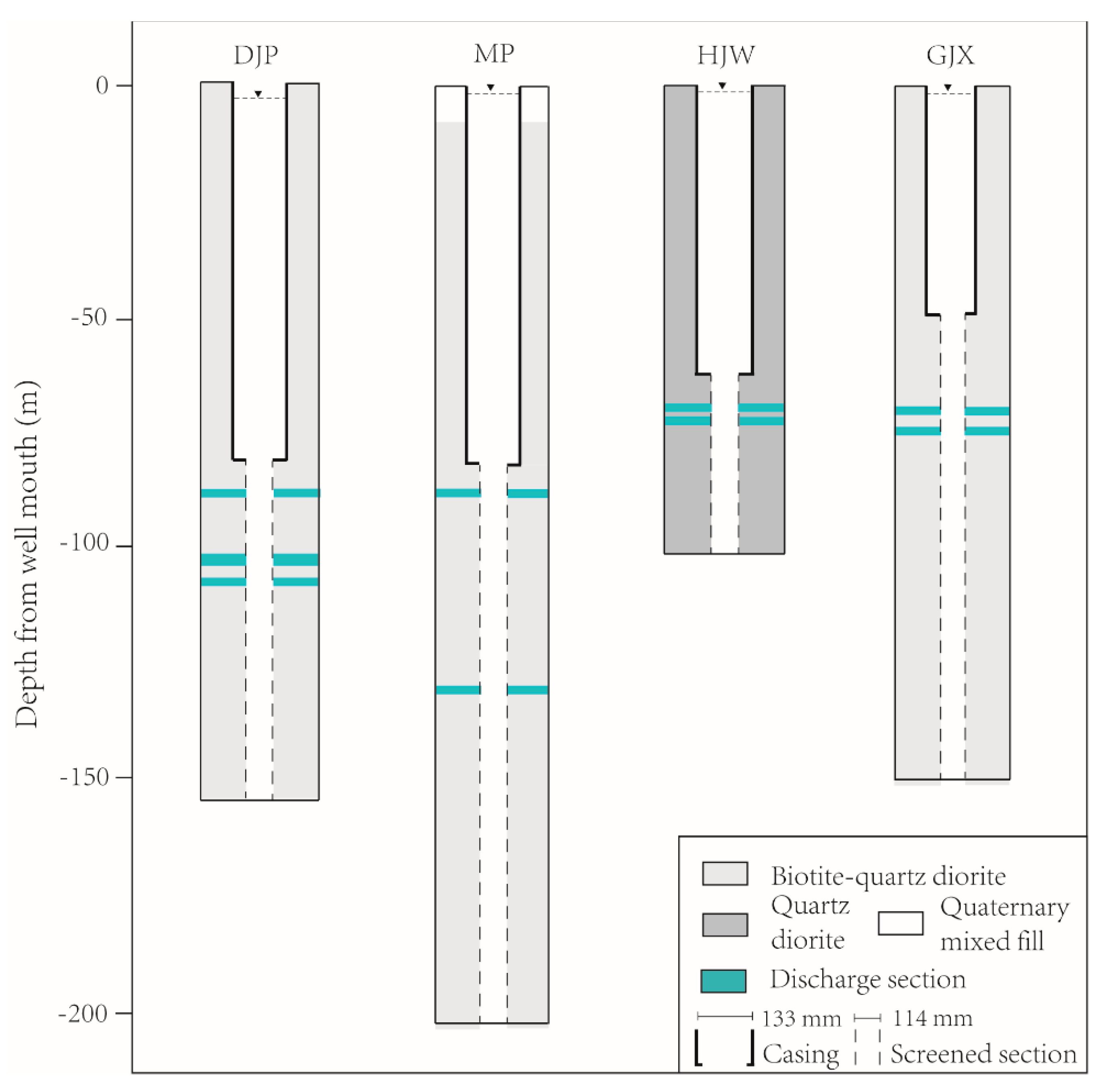
The selected four wells, Dingjiaping (DJP), Maoping (MP), Hanjiawan (HJW) and Gaojiaxi (GJX), are located around the Three Gorges Dam in Hubei Province. Three of the wells, DJP, MP and GJX, are located in Yichang County, and the MP well is located in Zigui County. The maximum distance between the four wells is about 11 km. These wells are part of the Three Gorges well network, which was built by the Institute of Geology, China Earthquake Administration for monitoring the reservoir-induced seismicity. The geological setting and location of the four wells are provided in Figure 1. Both the DJP and HJW wells are located on the north side of the Three Gorges Dam, which is on the west side of a small ditch in the hilly area of the north bank of the Yangtze River. The MP and GJX wells are located on the south side of the Three Gorges Dam, which is on the first terrace of the Yangtze River. The aquifer lithology of the four wells is the intrusive quartz diorite (Figure 2). In detail, the lithology of the DJP well is grey biotite quartz diorite () between 0–153.1 m; the lithology of the MP well is greyish-green and pink biotite quartz diorite () between 10–200.5 m; the lithology of the HJW well is grey quartz diorite () between 0–100.5 m; the lithology of the GJX well is grey biotite quartz diorite () between 0–150 m. The lithology outside the well area is mainly Ediacaran metamorphic rocks (E), Paleozoic sedimentary rocks (Pz) and granite ().
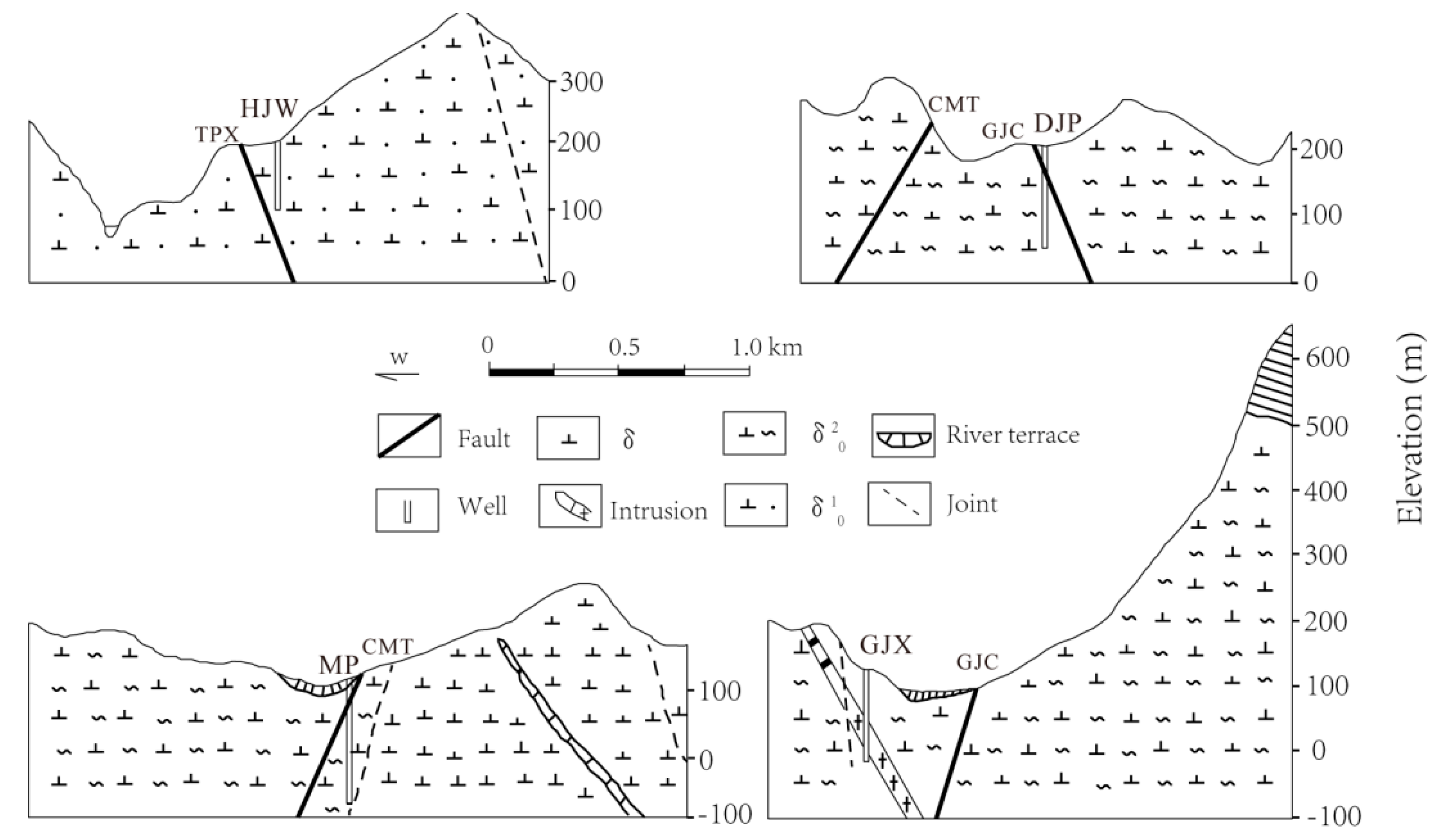
There are three faults adjacent to the four wells: the Gaojiachong (GJC) fault, the Changmutuo (CMT) fault and the Taipingxi (TPX) fault. The GJC fault is an NNW-trending compressive fault and, it dips from N60° E to N85° E. Its general width is 16~23 m. Inner the fault, the mylonite is 0.3~1.05 m wide; in some places, there are 0.5 m wide breccia and 0.5~1.3 m wide phyllite with a wavy extension; there are several veins filled in the fault. The CMT fault is a 20~25 m wide extensional fault. Its trending is NNE in the north section, SN in the middle section and NNW in the south section. The fault dips from N70° E to N83° E. The fault is zigzag extending. The mylonite in the fault zone is 0.5~1 m wide and the breccia is 5~15 m thick. The TPX fault is an NNW-trending compressive fault and it dips from N60° E to about N80° E. Its general width is 30~40 m. Inner the fault, the mylonite is 0.1~0.8 m wide and it was well cemented and silicified; the fractured rock is 5~12 m wide; the block rock is 18~40 m wide and it has a 1~4 m wide muddy belt in it [30].
The spatial relationship between the three faults and the four wells is displayed in Figure 3, which is based on a 1:50,000 geological map, a field investigation and a geochemical exploration (gaseous Hg) [29]. Figure 3 shows that the DJP well and the MP well penetrate the GJC fault and the CMT fault, respectively. The HJW well and the GJX well are adjacent to the TPX fault and the GJC fault, respectively.
The four wells were drilled between 1998 and 1999 by the Hebei Geological Engineering Exploration Institute with the same method: the inner diameter of the casing section is 133 mm and the inner diameter of the naked section is 114 mm. Some basic information of the four wells is shown in Table 1. All of these wells penetrate a confined aquifer, and their depths of screened section are approximately the same. The water chemistry and isotope measurement results of the four wells are shown in Table 2. The hydrochemical type of the groundwater sampled from these wells is HCO3-Ca, which is the same as the water sampled from the adjacent rivers and some of the springs. The stable hydrogen isotope () and stable oxygen isotope () of the four wells have similar values: −36.9~−59.6 for and −5.84~−8.30 for . The ratio of and is consistent with the standard equation of the global meteoric water line, indicating that the groundwater in the four wells is the cause of infiltration of atmospheric precipitation.
Continuous water level measurements in the four wells have been conducted since 2001. The water levels are measured every minute by a DSW-1 digital recorder which was developed by the Hubei Earthquake Administration. The recorder is a pressure-based transducer with a precision of 1 mm. The transducers of the four wells, DJP, MP, HJW and GJX, were placed at 4.47 m, 9.88 m, 11.86 m and 11.97 m below their well mouths, respectively. The water level recorded refers to the distance between the water table and the transducer. All of the wells are open and can record apparent Earth tides.
3. Earthquake-Induced Water Level Changes
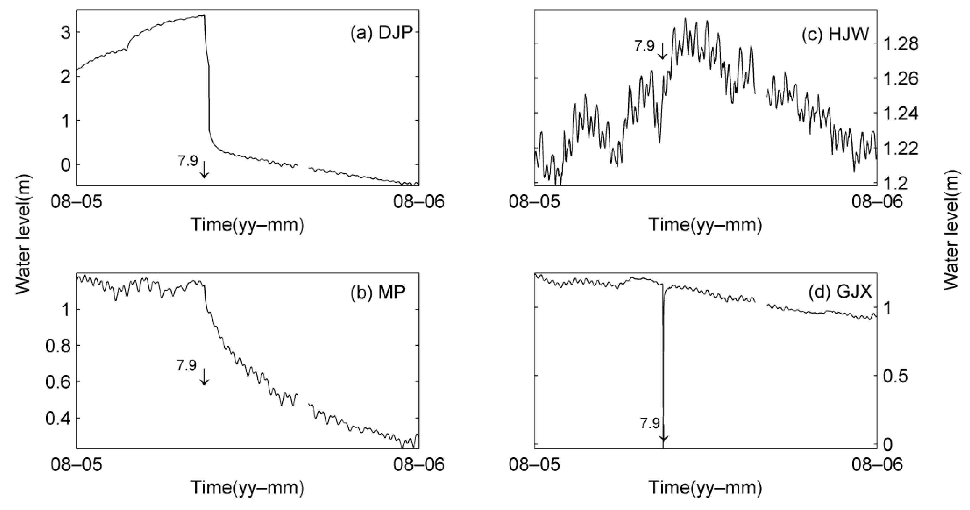
The 2008 Wenchuan MW 7.9 earthquake, an intraplate thrust devastating earthquake, induced significant water level changes in the four wells from the Three Gorges well network. The earthquake is about 720 km away from the four wells. The hydrographs of the water level changes after the earthquake are shown in Figure 4.
Based on the characteristics of the water level changes induced by the Wenchuan earthquake, there are two types of water level changes: the sustained water level changes which were recorded in the DJP and MP wells, and the transient water level changes which were recorded in the HJW and GJX wells. In detail, the DJP well recorded a rapid drop with a magnitude of 2.3 m in the first 8 h and a 0.76 m drop in the following 15 days. The MP well slowly dropped 1.13 m in 19 days after the earthquake. The HJW well recorded a water level drop with a magnitude of 0.067 m and recovered to the pre-earthquake level in less than an hour after the passage of the seismic waves. The GJX well recorded a rapid drop with a magnitude of 1.16 m in the first hour and recovered to the pre-earthquake level in two hours (Table 3 and Figure 4).
4. Method
In order to further analyze the water level changes induced by the Wenchuan earthquake, we analyzed the four wells’ hydraulic properties, because the hydraulic properties can be changed following an earthquake, which is one plausible explanation for the hydrologic changes induced by earthquakes [5,19,31]. The hydraulic properties can be obtained by using the results of the tidal behavior of water level, on the basis that the phase shift and tidal factor obtained from the tidal behavior can be mapped into the permeability and storage coefficient, respectively.
4.1. Analysis of Tidal Behavior
The purpose of analysis of tidal behavior is to obtain the phase shift and tidal factor. The phase shift is the time difference of the water level oscillations relative to the Earth tides, negative means the water level lags behind the Earth tides and positive means the water level is ahead of the Earth tides. The tidal factor is the amplitude ratio of water level over Earth tides. The phase shift and tidal factor were extracted by the program VAV [32]. The VAV program is based on a harmonic analysis method, which can give the most prominent 1-day tidal bands (O1, S1, K1, M1, Q1, J1, etc.) and half-day tidal bands (M2, S2, K2, N2, L2, etc.). The equation of harmonic analysis in the VAV program is:
where y(T) is the observation data, a(T)x is the tidal part, p(T)z(T) is the drift part, and ε(T) is the noise of the observation.
y(T) = a(T)x + p(T)z(T) + ε(T)
Before doing harmonic analysis, some large steps and spikes caused by the instrument malfunction or anthropogenic influence were removed. The data was divided into segments with each segment of 30 days. The sliding length of 3 days was used to get a continuous phase shift and tidal factor. The results of the M2 wave were used due to its greater amplitude and less contamination. In order to compare the changes before and after the earthquake more easily, we removed the results containing the co-seismic changes which can increase the errors of the harmonic analysis.
4.2. Estimation of the Hydraulic Properties
There are two models available for estimating hydraulic properties: a horizontal flow model for the well with a negative phase shift [6,33] and a vertical flow model for the well with a positive phase shift [34,35]. The storage coefficient and the transmissivity can be estimated by the measured phase shift and tidal factor. The transmissivity T can be converted to the permeability K by:
where μ is the fluid dynamic viscosity, ρ is the fluid density, g is the gravitational acceleration, and d is the well’s open interval.
The phase shift of the DJP, MP and HJW wells is negative, so the horizontal flow model was used; the vertical flow model was applied to the GJX well since its phase shift is positive. Based on these models, we estimated the hydraulic properties using the results of the tidal behavior and the well geometries.
5. Results
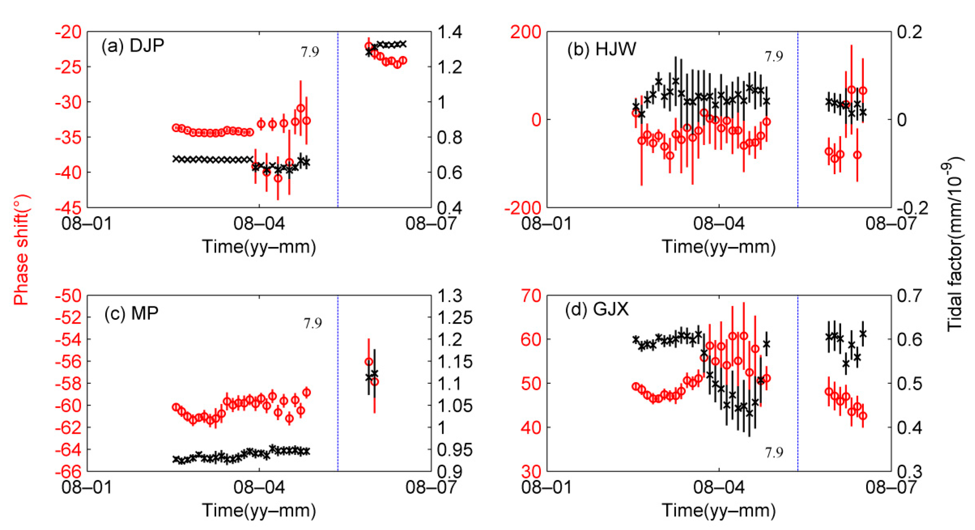
The results of the water level tidal behavior in the four wells are displayed in Table 3 and Figure 5. It shows that the tidal behavior experienced obvious changes after the Wenchuan MW 7.9 earthquake in both the DJP and MP wells. The DJP well had a negative phase shift of about −33° and a tidal factor of about 0.63 mm/10−9 before the Wenchuan earthquake. The phase shift and tidal factor increased by 33% and 94% after the earthquake, respectively. The MP well had a phase shift of about −59° and a large tidal factor of about 0.91 mm/10−9 before the earthquake. After the earthquake, the root-mean-square error of the water level tides increased and the phase shift and tidal factor increased by approximately 6% and 19%, respectively. While the tidal behavior did not occur any obvious change before and after the Wenchuan earthquake in both the HJW and GJX wells. In the HJW well, phase shift (−55°) and tidal factor (0.06 mm/10−9) maintained the same level before and after the earthquake. The GJX well had a positive phase shift of about 51° and a tidal factor of about 0.57 mm/10−9 before and after the earthquake.
The hydraulic properties of the DJP, MP and GJX wells are provided in Table 3. The hydraulic properties of the HJW well were not obtained because its tidal factor (0.06 mm/10−9) is too low. The results of the DJP and MP wells are consistent with the results of Shi et al. [36] and Zhang et al. [37], who used the same method as our study. Table 3 shows that the permeability ranged from 10−13 to 10−16 m2 and the storage coefficient is in the order of 10−5 before the Wenchuan MW 7.9 earthquake. After the earthquake, the permeability and the storage coefficient changed in the DJP and MP wells, while unchanged in the GJX well. The permeability of the DJP well and the MP well increased by 67% and 24%, respectively, and the storage coefficient decreased by 45% and 5%, respectively.
6. Discussion
We analyzed the earthquake-induced hydrologic changes in four wells around the Three Gorges Dam. The results show that two of the wells that penetrate the fault damage zones showed similar changes in the water level, tidal behavior and hydraulic properties following the Wenchuan MW 7.9 earthquake, while the changes are similar for the other two wells that do not penetrate any fault damage zone. The analysis provides a basis for discussing the relationship between earthquake-induced hydrologic changes and faults, as well as the possible mechanism.
The four wells studied are 720 km apart from the epicentre of the Wenchuan earthquake. The earthquake-induced water level changes in these wells should be caused by the dynamic strain because the static strain (1.4 × 10⁻⁸) is too low to account for the water level changes [38]. The static strain was calculated by the Coulomb program [39]. The four wells are close to each other, so their differences in the changes of water level, tidal behavior and hydraulic properties following the Wenchuan earthquake should have little to do with the seismic input. It should be attributed to the differences between wells or differences in local hydrogeological settings. The four wells have little differences in the borehole logging, aquifer lithology and water chemistry type. Their main differences are in the hydrogeological settings. Based on the hydrogeological settings of the four wells, the wells can be divided into two groups. Firstly, both the DJP and HJW wells are on the north side of the Three Gorges Dam, and both wells are on the west of a small ditch in the hilly area of the north bank of the Yangtze River. Secondly, both the MP and GJX wells are on the south bank of the Three Gorges Dam, and both wells are on the first terrace of the Yangtze River (Figure 1 and Figure 3). However, these wells with similar hydrogeological settings showed different changes in the water level, tidal behavior and hydraulic properties following the Wenchuan earthquake (Table 3, Figure 4 and Figure 5), which suggested that the earthquake-induced water level, tidal behavior and hydraulic properties changes in the four wells may not have much to do with the hydrogeological settings.
It is worth noting that both the DJP and MP wells penetrate faults, while both the HJW and GJX wells do not penetrate any faults according to the borehole logging (Figure 3). Both the wells penetrating the faults, DJP and MP, recorded sustained water level changes and had changes in the tidal behavior and hydraulic properties following the Wenchuan earthquake, while the wells not penetrating any fault, HJW and GJX, recorded transient water level changes and had no change in the tidal behavior and hydraulic properties after the earthquake (Table 3, Figure 4 and Figure 5). Thus, we suggested that the changes in the water level, tidal behavior and hydraulic properties induced by the Wenchuan earthquake in the four wells may be related to the faults.
Why are earthquake-induced hydrologic changes related to faults? We believe that it may be because the rocks in fault damage zones are more fractured, and the detrital components are more easily removed by seismic waves. Brodsky et al. [5] proposed a mechanism for earthquake-induced hydrologic changes in the far-field, in which the aquifer permeability increased because a temporary barrier can be removed by more rapid groundwater flow caused by the seismic waves. The mechanism was supported by many observations and experiments [6,33,40,41,42]. In this study, the two wells which penetrate faults showed phase shift increases and permeability enhancement following the Wenchuan earthquake. This result is consistent with our interpretation of why the earthquake-induced hydrologic changes are related to faults. The permeability is an essential parameter of a fault zone. Both the work of Yan et al. (2016), and our work, indicate that the permeability of a fault zone is more sensitive to the dynamic strain than that away from the fault zone. If this understanding is supported by more observations, a continuous water level monitoring in a fault zone may be useful for monitoring its permeability and stress state.
7. Conclusions
Using the data of four wells that have similar borehole logging, aquifer lithology and water chemistry type around the Three Gorges Dam, we examined the relationship between earthquake-induced hydrologic changes and faults. The results indicate that two of the wells that penetrate the fault damage zones recorded sustained water level changes and experienced changes in tidal response and hydraulic properties following the Wenchuan MW 7.9 earthquake, while the other two wells not, penetrating any fault damage zones, recorded transient water level changes and had no change in the tidal response and hydraulic properties after the earthquake. Based on the results, we suggested that faults may play an important controlling role on earthquake-induced hydrologic changes.
Author Contributions
Conceptualization, R.Y., Y.M. and G.W.; methodology, Y.M.; software, Y.M. and B.W.; validation, C.Y. (Chen Yu), C.Y. (Chong Yue) and Y.W.; formal analysis, H.Y.; writing—original draft preparation, Y.M.; writing—review and editing, Y.M. and R.Y.; visualization, R.Y.; funding acquisition, H.Y., R.Y. and Y.M. All authors have read and agreed to the published version of the manuscript.
Funding
This research work was supported by the National Natural Science Foundation of China (U2039205), the National Key R&D Program of China (2018YFC1503305) and the Spark Program of Earthquake Science of China (XH21046Y).
Institutional Review Board Statement
Not applicable.
Informed Consent Statement
Not applicable.
Data Availability Statement
All data can be obtained from the corresponding author by request.
Acknowledgments
We are grateful to Zheming Shi and Yongtai Che for providing the basic data of the Three Gorges well network. We are grateful to anonymous reviewers for their helpful comments and suggestions.
Conflicts of Interest
The authors declare that they have no conflict of interest.
References
- Cooper, H.H.; Bredehoeft, J.D.; Papadopulos, I.S.; Bennett, R.R. The response of well-aquifer systems to seismic waves. J. Geophys. Res. Space Phys. 1965, 70, 3915–3926. [Google Scholar] [CrossRef]
- Liu, L.-B.; Roeloffs, E.; Zheng, X.-Y. Seismically induced water level fluctuations in the Wali Well, Beijing, China. J. Geophys. Res. Space Phys. 1989, 94, 9453–9462. [Google Scholar] [CrossRef]
- Roeloffs, E.A. Persistent water level changes in a well near Parkfield, California, due to local and distant earthquakes. J. Geophys. Res. Space Phys. 1998, 103, 869–889. [Google Scholar] [CrossRef]
- Wang, C.Y.; Cheng, L.H.; Chin, C.V.; Yu, S.B. Coseismic hydrologic response of an alluvial fan to the 1999 Chi-Chi earthquake, Taiwan. Geology 2001, 29, 831–834. [Google Scholar] [CrossRef]
- Brodsky, E.E.; Roeloffs, E.; Woodcock, D.; Gall, I.; Manga, M. A mechanism for sustained groundwater pressure changes induced by distant earthquakes. J. Geophys. Res. Space Phys. 2003, 108, 2390. [Google Scholar] [CrossRef] [Green Version]
- ElKhoury, J.E.; Brodsky, E.E.; Agnew, D.C. Seismic waves increase permeability. Nature 2006, 441, 1135–1138. [Google Scholar] [CrossRef] [PubMed]
- Wakita, H. Water Wells as Possible Indicators of Tectonic Strain. Science. 1975, 189, 553–555. [Google Scholar] [CrossRef] [PubMed]
- Muir-Wood, R.; King, G.C.P. Hydrological signatures of earthquake strain. J. Geophys. Res. Space Phys. 1993, 98, 22035–22068. [Google Scholar] [CrossRef]
- Quilty, E.G.; Roeloffs, E.A. Water-level changes in response to the 20 December 1994 earthquake near Parkfield, California. Bull. Seism. Soc. Am. 1997, 87, 310–317. [Google Scholar] [CrossRef]
- Zhang, Y.; Huang, F.Q. Mechanism of different coseismic water-level changes in wells with similar epicentral distances of intermediate field. Bull. Seismol. Soc. Am. 2011, 101, 1531–1541. [Google Scholar] [CrossRef]
- Shi, Z.; Wang, G.; Liu, C. Co-Seismic Groundwater Level Changes Induced by the May 12, 2008 Wenchuan Earthquake in the Near Field. Pure Appl. Geophys. Pageoph. 2013, 170, 1773–1783. [Google Scholar] [CrossRef]
- Lai, G.; Jiang, C.; Han, L.; Sheng, S.; Ma, Y. Co-seismic water level changes in response to multiple large earthquakes at the LGH well in Sichuan, China. Tectonophysics 2016, 679, 211–217. [Google Scholar] [CrossRef]
- Yang, Z.-Z.; Deng, Z.-H.; Zhao, Y.-X.; Zhu, P.-Y. Preliminary study on coseismic step-like changes of water-level in the Dazhai well, Simao city, Yunnan Province. Acta Seism. Sin. 2005, 18, 611–617. [Google Scholar] [CrossRef]
- Wang, C.; Manga, M. Hydrologic responses to earthquakes and a general metric. Geofluids 2010, 10, 206–216. [Google Scholar] [CrossRef] [Green Version]
- Cox, S.; Rutter, H.; Sims, A.; Manga, M.; Weir, J.; Ezzy, T.; White, P.; Horton, T.; Scott, D. Hydrological effects of the M W 7.1 Darfield (Canterbury) earthquake, 4 September 2010, New Zealand. N. Z. J. Geol. Geophys. 2012, 55, 231–247. [Google Scholar] [CrossRef] [Green Version]
- Yan, R.; Woith, H.; Wang, R. Groundwater level changes induced by the 2011 Tohoku earthquake in China mainland. Geophys. J. Int. 2014, 199, 533–548. [Google Scholar] [CrossRef] [Green Version]
- Ma, Y.; Huang, F. Coseismic water level changes induced by two distant earthquakes in multiple wells of the Chinese mainland. Tectonophysics 2017, 694, 57–68. [Google Scholar] [CrossRef]
- Luca, G.D.; Carlo, G.D.; Tallini, M. A record of changes in the Gran Sasso groundwater before, during and after the 2016 Amatrice earthquake, central Italy. Sci. Rep. 2018, 8, 15982. [Google Scholar] [CrossRef] [PubMed]
- Shi, Z.M.; Zhang, S.C.; Yan, R.; Wang, G.C. Fault zone permeability decrease following large earthquakes in a hy-drothermal system. Geophys. Res. Lett. 2018, 453, 1387–1394. [Google Scholar] [CrossRef]
- He, A.; Singh, R.P. Groundwater level response to the Wenchuan earthquake of May 2008. Geomat. Nat. Hazards Risk 2018, 10, 336–352. [Google Scholar] [CrossRef] [Green Version]
- Huang, F.-Q.; Jian, C.-L.; Tang, Y.; Xu, G.-M.; Deng, Z.-H.; Chi, G.-C. Response changes of some wells in the mainland subsurface fluid monitoring network of China, due to the September 21, 1999, Ms7.6 Chi-Chi Earthquake. Tectonophysics 2004, 390, 217–234. [Google Scholar] [CrossRef]
- Shi, Z.; Wang, G.; Manga, M.; Wang, C.-Y. Continental-scale water-level response to a large earthquake. Geofluids 2014, 15, 310–320. [Google Scholar] [CrossRef]
- Yan, R.; Wang, G.; Shi, Z. Sensitivity of hydraulic properties to dynamic strain within a fault damage zone. J. Hydrol. 2016, 543, 721–728. [Google Scholar] [CrossRef]
- Xue, L.; Brodsky, E.E.; Erskine, J.; Fulton, P.M.; Carter, R. A permeability and compliance contrast measured hydrogeologically on the San Andreas Fault. Geochem. Geophys. Geosystems 2016, 17, 858–871. [Google Scholar] [CrossRef] [Green Version]
- Brodsky, E.E.; van der Elst, N.J. The uses of dynamic earthquake triggering. Annu. Rev. Earth Planet. Sci. 2014, 42, 317–339. [Google Scholar] [CrossRef]
- Zhang, L.; Yang, D.; Liu, Y.; Che, Y.; Qin, D. Impact of impoundment on groundwater seepage in the Three Gorges Dam in China based on CFCs and stable isotopes. Environ. Earth Sci. 2014, 72, 4491–4500. [Google Scholar] [CrossRef]
- Zhang, L.; Yang, D.; Zhu, D. Denudation rates of crystalline rock in the Huangling anticline of the Three Gorges of the Yangtze River in China since the Eocene. Sci. China Ser. D Earth Sci. 2003, 46, 928–940. [Google Scholar] [CrossRef]
- Che, Y.T.; Chen, J.H.; Zhang, L.F.; Yu, J.Z.; Liu, C.L.; Zhang, W.H. Study of the reservoir-induced Hujiaping MS 4.1 earthquake in the Three Gorges Dam area. Earthquake 2009, 29, 1–13. (In Chinese) [Google Scholar]
- Che, Y.T. Three Gorges Groundwater Monitoring Well Network; Institute of Geology, China Earthquake Administration: Harbin, China, 2001; pp. 1–156. (In Chinese) [Google Scholar]
- Liu, C.L. Research on Precursory Anomalies and Co-Seismic Response of Groundwater Associated with Wenchuan Earthquake. Ph.D. Thesis, China University of Geosciences, Wuhan, China, 2012; pp. 27–33. [Google Scholar]
- Rojstaczer, S.; Wolf, S.; Michel, R. Permeability enhancement in the shallow crust as a cause of earthquake-induced hydrological changes. Nat. Cell Biol. 1995, 373, 237–239. [Google Scholar] [CrossRef]
- Venedikov, A.P.; Arnoso, J.; Vieira, R. VAV: A program for tidal data processing. Comput. Geosci. 2003, 29, 487–502. [Google Scholar] [CrossRef]
- Hsieh, P.A.; Bredehoeft, J.D.; Farr, J.M. Determination of aquifer transmissivity from Earth tide analysis. Water Resour. Res. 1987, 23, 1824–1832. [Google Scholar] [CrossRef]
- Wang, H.F. Theory of Linear; Princeton University Press: Princeton, NJ, USA, 2000. [Google Scholar]
- Xue, L.; Li, H.-B.; Brodsky, E.E.; Xu, Z.-Q.; Kano, Y.; Wang, H.; Mori, J.J.; Si, J.-L.; Pei, J.-L.; Zhang, W.; et al. Continuous Permeability Measurements Record Healing Inside the Wenchuan Earthquake Fault Zone. Science 2013, 340, 1555–1559. [Google Scholar] [CrossRef] [PubMed]
- Shi, Z.; Wang, G.; Liu, C.; Mei, J.; Wang, J.; Fang, H. Coseismic response of groundwater level in the Three Gorges well network and its relationship to aquifer parameters. Chin. Sci. Bull. 2013, 58, 3080–3087. [Google Scholar] [CrossRef] [Green Version]
- Zhang, S.; Shi, Z.; Wang, G. Comparison of aquifer parameters inferred from water level changes induced by slug test, earth tide and earthquake—A case study in the three Gorges area. J. Hydrol. 2019, 579, 124169. [Google Scholar] [CrossRef]
- Manga, M.; Brodsky, E. Seismic Triggering of Eruptions in The Far Field: Volcanoes and Geysers. Annu. Rev. Earth Planet. Sci. 2006, 34, 263–291. [Google Scholar] [CrossRef] [Green Version]
- Okada, Y. Internal deformation due to shear and tensile faults in a half-space. Bull. Seism. Soc. Am. 1992, 82, 1018–1040. [Google Scholar] [CrossRef]
- Matsumoto, N.; Roeloffs, E.A. Hydrological response to earthquakes in the Haibara well, central Japan—II. Possible mechanism inferred from time-varying hydraulic properties. Geophys. J. Int. 2003, 155, 899–913. [Google Scholar] [CrossRef] [Green Version]
- Manga, M.; Beresnev, I.; Brodsky, E.E.; Elkhoury, J.E.; Elsworth, D.; Ingebritsen, S.E.; Wang, C.Y. Changes in per-meability caused by transient stresses: Field observations, experiments, and mechanisms. Rev. Geophys. 2012, 50. [Google Scholar] [CrossRef]
- Wang, B.; Liu, Y.W.; Sun, X.L.; Ma, Y.C.; Zhang, L.; Ren, H.W.; Fang, Z. Hydrogeological and geochemical obser-vations for earthquake prediction research in China: A brief overview. Pure Appl. Geophys. 2018, 175, 2541–2555. [Google Scholar] [CrossRef]
Figure 1.
Geological setting and location of the four wells around the Three Gorges Dam. The inset is an enlargement of the study area. The abbreviation W.E. in the inset represents the Wenchuan earthquake. The figure was adapted from Zhang et al. [26].
Figure 1.
Geological setting and location of the four wells around the Three Gorges Dam. The inset is an enlargement of the study area. The abbreviation W.E. in the inset represents the Wenchuan earthquake. The figure was adapted from Zhang et al. [26].

Figure 2.
Structure and lithologic log of the four wells. The figure was adapted from Che [29].
Figure 2.
Structure and lithologic log of the four wells. The figure was adapted from Che [29].

Figure 3.
Relationship between the four wells and faults. The figure was adapted from Che [29].
Figure 3.
Relationship between the four wells and faults. The figure was adapted from Che [29].

Figure 4.
Water level changes induced by the 12 May 2008, Wenchuan MW 7.9 earthquake. The arrow represents the origin time of the earthquake.
Figure 4.
Water level changes induced by the 12 May 2008, Wenchuan MW 7.9 earthquake. The arrow represents the origin time of the earthquake.

Figure 5.
Tidal responses before and after the Wenchuan earthquake. The dotted line represents the origin time of the earthquake.
Figure 5.
Tidal responses before and after the Wenchuan earthquake. The dotted line represents the origin time of the earthquake.


Table 1.
Basic information regarding the four wells around the Three Gorges Dam.
| Well Name | Depth (m) | Casing Length (m) | Screened Section (m) | Discharge Section (m) | Aquifer Lithology | Relationship with Fault |
|---|---|---|---|---|---|---|
| DJP | 153.1 | 0–80 | 80–153.1 | 86, 103–106, 116 | Biotite-quartz diorite | PenetrateGJC fault |
| MP | 200.5 | 0–80 | 80–200.5 | 85, 130 | Biotite-quartz diorite | Penetrate CMT fault |
| HJW | 100.5 | 0–60 | 60–100.5 | 69.4, 70–72 | Quartz diorite | Near TPX fault |
| GJX | 150 | 0–50 | 50–150 | 69.3, 75 | Biotite-quartz diorite | Near GJC fault |
Table 2.
Water chemistry and isotope measurement results in the studied four wells.
| Well Name | Anion (mg/L) | Cation (mg/L) | Salinity (ng/L) | Isotope (‰) | ||||||
|---|---|---|---|---|---|---|---|---|---|---|
| HCO3− | SO42− | Cl− | K+ | Na+ | Ca2+ | Mg2+ | δD | δ18O | ||
| DJP | 90.8 | 32.6 | 22.8 | 3.77 | 15.2 | 26.57 | 4.63 | 0.1573 | −36.9 | −5.84 |
| MP | 140 | 4.15 | 17.5 | 2.89 | 17.9 | 24.5 | 2.63 | 0.7965 | −59.6 | −8.3 |
| HJW | 192 | 12.4 | 17.9 | 4.78 | 11.12 | 43.32 | 9.45 | 0.2114 | −51.2 | −6.77 |
| GJX | 60.3 | 21.3 | 12. | 1.68 | 10.1 | 17.13 | 4.81 | 0.1202 | −47.2 | −7.0 |
Note: the data comes from Che [29].
Table 3.
Water level, tidal behavior and hydraulic properties before and after the Wenchuan MW 7.9 earthquake.
Table 3.
Water level, tidal behavior and hydraulic properties before and after the Wenchuan MW 7.9 earthquake.
| Well Name | WL (m) | ΔWL (m) | Phase (°) | ΔPhase (°) | TF (mm/) 10−9 | ΔTF (mm/) 10−9) | K (m2) | S | ||
|---|---|---|---|---|---|---|---|---|---|---|
| DJP | 3.38 | −3.06 | −32.53 | 10.88 | 0.63 | 0.59 | 3.3 × 10⁻¹⁵ | 0.67 | 8.9 × 10⁻⁵ | −0.45 |
| MP | 1.13 | −1.13 | −59 | 3.42 | 0.91 | 0.17 | 6.2 × 10⁻¹⁶ | 0.24 | 5.0 × 10⁻⁵ | −0.05 |
| HJW | 1.24 | −0.067 | −55.00 | 0.06 | ||||||
| GJX | 1.17 | −1.16 | 51.29 | 0.57 | 2.6 × 10⁻¹³ | 1.8 × 10⁻⁵ |
Note: WL, Phase, TF, K, and S represent water level, phase shift, tidal factor, permeability and storage coefficient before the Wenchuan earthquake, respectively. The symbol Δ represents the value of the post-earthquake minus the value of the pre-earthquake. The symbol represents the rate of change. The Δ and δ that unchanged were left blank in the table. The TF of the HJW well is too low to estimate its K and S, which were also left blank.
Publisher’s Note: MDPI stays neutral with regard to jurisdictional claims in published maps and institutional affiliations. |
© 2021 by the authors. Licensee MDPI, Basel, Switzerland. This article is an open access article distributed under the terms and conditions of the Creative Commons Attribution (CC BY) license (https://creativecommons.org/licenses/by/4.0/).
Share and Cite
MDPI and ACS Style
Ma, Y.; Wang, G.; Yan, R.; Wang, B.; Yu, H.; Yu, C.; Yue, C.; Wang, Y. Relationship between Earthquake-Induced Hydrologic Changes and Faults. Water 2021, 13, 2795. https://0-doi-org.brum.beds.ac.uk/10.3390/w13192795
AMA Style
Ma Y, Wang G, Yan R, Wang B, Yu H, Yu C, Yue C, Wang Y. Relationship between Earthquake-Induced Hydrologic Changes and Faults. Water. 2021; 13(19):2795. https://0-doi-org.brum.beds.ac.uk/10.3390/w13192795
Chicago/Turabian StyleMa, Yuchuan, Guangcai Wang, Rui Yan, Bo Wang, Huaizhong Yu, Chen Yu, Chong Yue, and Yali Wang. 2021. "Relationship between Earthquake-Induced Hydrologic Changes and Faults" Water 13, no. 19: 2795. https://0-doi-org.brum.beds.ac.uk/10.3390/w13192795
Note that from the first issue of 2016, this journal uses article numbers instead of page numbers. See further details here.