
Migration of 238U and 226Ra Radionuclides in Technogenic Permafrost Taiga Landscapes of Southern Yakutia, Russia


Abstract
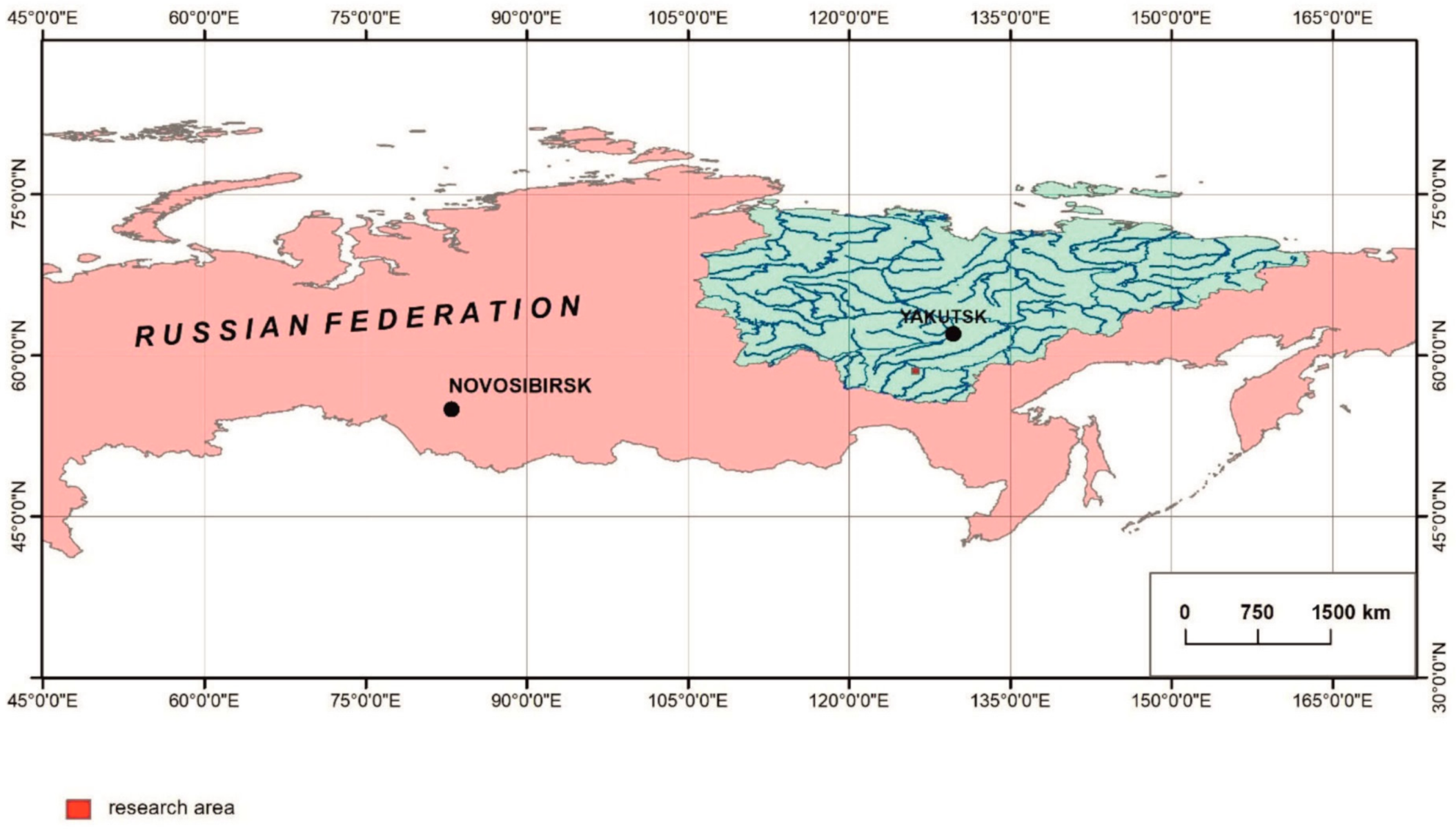
:1. Introduction
2. Materials and Methods
3. Results and Discussion
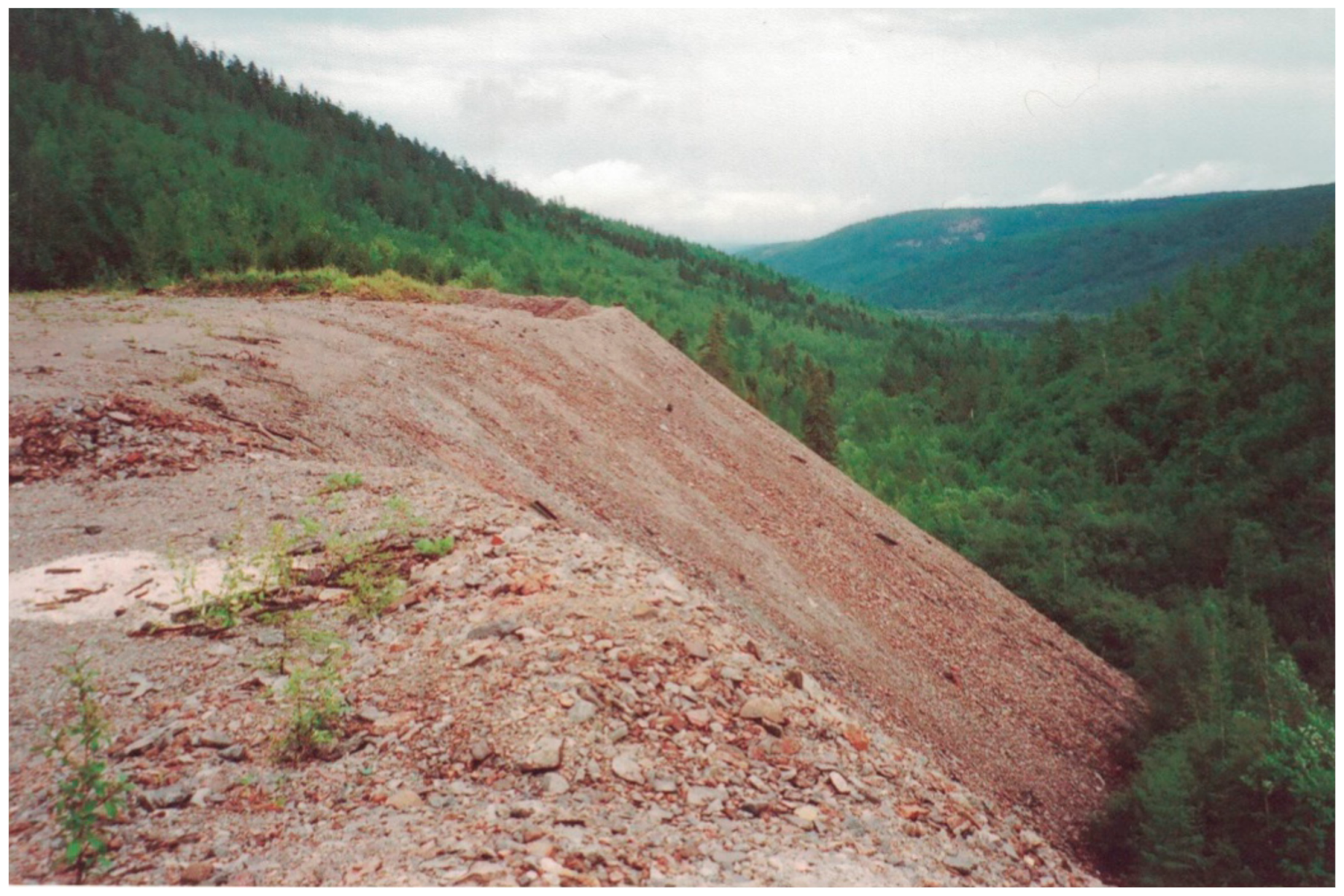
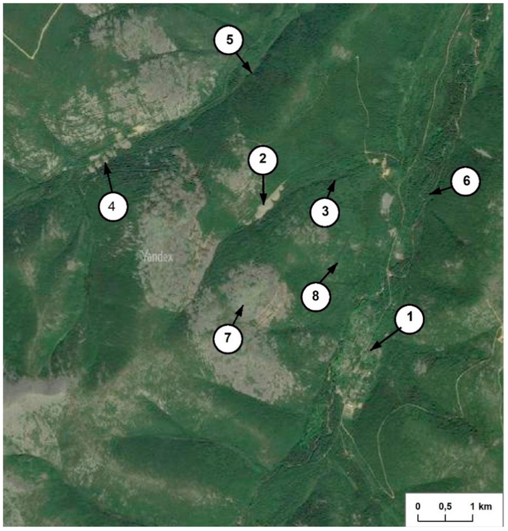
3.1. Dumps of Radioactive Rock
3.2. Surface Waters
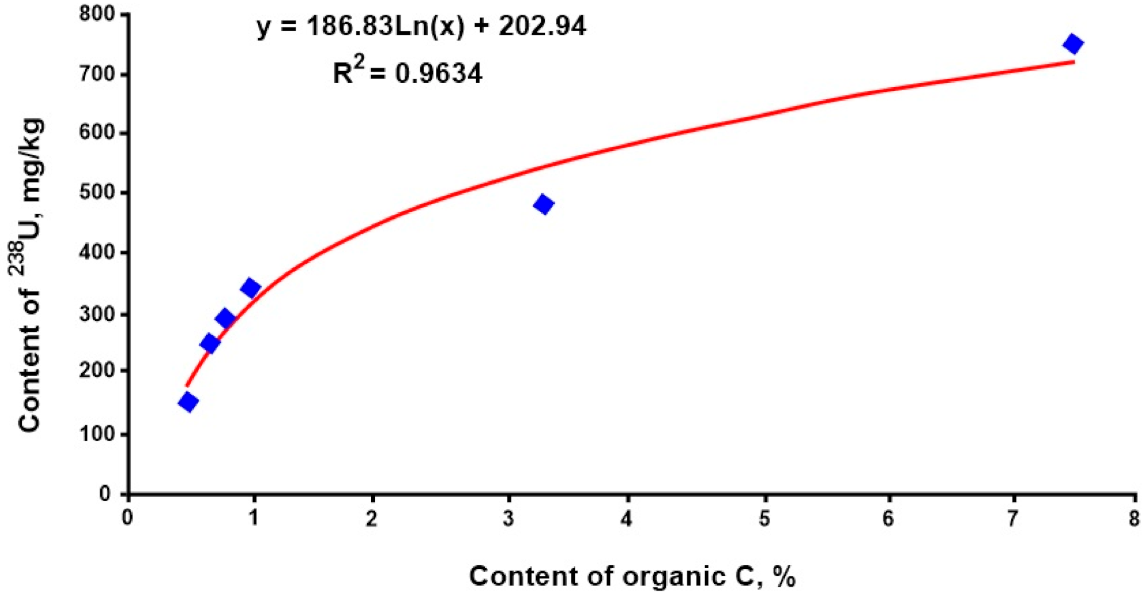
3.3. Soil
3.4. Plants
4. Conclusions
Author Contributions
Funding
Institutional Review Board Statement
Informed Consent Statement
Data Availability Statement
Conflicts of Interest
References
- Glazovskaya, M.A. Landscape-Geochemical Systems and Their Resistance to Technogenesis. Biogeochemical Cycles in the Biosphere; Nauka: Moscow, Russia, 1976; pp. 99–119. [Google Scholar]
- Titaeva, N.A.; Maslov, V.I.; Taskaev, A.I.; Aleksakhin, R.M. Radioactive Elements in Technogenic Environmental Pollution. Problems of Radiogeology; Nauka: Moscow, Russia, 1983; pp. 224–237. [Google Scholar]
- Mosinets, V.N. Radioactive waste of uranium mining enterprises and their impact on the environment. Atom. Energy 1991, 70, 282–288. [Google Scholar]
- Kornilov, A.N.; Ryabchikov, S.G. Waste of the Uranium Mining Industry (Radiation and Hygienic Aspects); Energoatomizdat: Moscow, Russia, 1992; 162p. [Google Scholar]
- Vinogradova, А.P. (Ed.) The Main Features of the Geochemistry of Uranium; Publishing House of the USSR Academy of Sciences: Moscow, Russia, 1963; 352p. [Google Scholar]
- Perelman, A.I. Geochemistry; Vysshaya Shkola: Moscow, Russia, 1989; 528p. [Google Scholar]
- Rachkova, N.G.; Shuktomova, I.I.; Taskaev, A.I. The State of Natural Radionuclides of Uranium, Radium and Thorium in Soils (review). Eurasian Soil Sci. 2010, 43, 651–658. [Google Scholar] [CrossRef]
- Evseeva, L.S.; Perelman, A.I.; Ivanov, K.E. Geochemistry of Uranium in the Hypergenesis Zone; Nauka: Moscow, Russia, 1974; 280p. [Google Scholar]
- Smyslov, A.A. Uranium and Thorium in the Earth’s Crust; Nedra: Leningrad, Russia, 1974; 232p. [Google Scholar]
- Gudzenko, V.V.; Dubinchuk, V.T. Radium and Radon Isotopes in Natural Waters; Nauka: Moscow, Russia, 1987; 156p. [Google Scholar]
- Bunzl, K.; Kretner, R.; Schramel, P.; Szeles, M.; Winklier, R. Speciation of 238U, 226Ra, 210Pb, 228Ra, and stable Pb in the soil near an exhaust ventilating shaft of uranium mine. Geoderma 1995, 67, 45–53. [Google Scholar] [CrossRef]
- Zielinski, R.A.; Chafin, D.T.; Banta, E.R.; Szabo, B.J. Use of 234U and 238U isotopes to evaluate contamination of near-surface ground water with uranium-mill effluent: A case study in south-central Colorado, U.S.A. Environ. Geol. 1997, 32, 124–136. [Google Scholar] [CrossRef]
- Nitzsche, O.; Merkel, B. Reactive transport modeling of uranium 238 and radium 226 in ground water of the Konigstein uranium mine, Germany. Hydrogeol. J. 1999, 7, 423–430. [Google Scholar] [CrossRef]
- Pozolotina, V.N.; Sobakin, P.I.; Molchanova, I.V.; Karavaeva, E.N.; Mikhailovskaya, L.N. Migration and biological effect of natural heavy radionuclides on plants. Ecology 2000, 31, 14–19. [Google Scholar] [CrossRef]
- Tsikritzis, L.I. Chemometry of the distribution and origin of 226Ra, 228Ra, 40K and 137Cs in the soil near the lignite fired plants of West Macedonia (Greece). J. Radioanal. Nuclear Chem. 2004, 261, 215–220. [Google Scholar] [CrossRef]
- Yermilov, A.; Yermilova, Y. Environmental and human dimensions of radioecological situation in Kazakhstan. Arid Ecosyst. 2005, 11, 39–48. [Google Scholar]
- Gedeonov, A.D.; Kolchin, I.V.; Maliskin, A.I.; Andreev, G.S. Uranium-234, uranium-235, uranium-238 in soils near Siberian chemical enterprises (Tomsk-7, Seversk). Radioprotection 2009, 44, 151–153. [Google Scholar] [CrossRef]
- Vodyanitsky, Y.N. Chemical aspects of the behavior of uranium in soils (review of literature). Eurasian Soil Sci. 2011, 44, 862–873. [Google Scholar] [CrossRef]
- Jeenbaev, B.M.; Kaldybayev, B.K.; Zholdybayev, B.T. Problems of radioecology and radiation safety of the former uranium production in Kyrgyzstan. Radiation biology. Radioecology 2013, 53, 428–431. [Google Scholar]
- Tserenpil, S.; Liu, O.C.; Maclov, O.D.; Fillipov, M.F.; Belov, A.G.; Norov, H.; Theng, B.К.G. Chemical and mineralogical composition of the Mongolian rural soils and their uranium sorption behavior. J. Environ. Radioact. 2013, 118, 105–112. [Google Scholar] [CrossRef] [PubMed]
- Sanzharova, N.I.; Ratnikov, A.N.; Fesenko, S.V.; Sviridenco, D.G. Review on uranium in soil: Levels, migration. Dokuchaev Soil Bull. 2019, 100, 117–132. [Google Scholar] [CrossRef]
- Chevychelov, A.P.; Sobakin, P.I. Content, Distribution and Forms of Migration of 238U in the Soils of Natural and Technogenic Landscapes of Southern Yakutia. Eurasian Soil Sci. 2020, 53, 117–125. [Google Scholar] [CrossRef]
- Moiseev, A.A.; Ivanov, V.I. Handbook of Dosimetry and Radiation Hygiene; Energoatomizdat: Moscow, Russia, 1984; 296p. [Google Scholar]
- Semenov, A.D. Manual on Chemical Analysis of Surface Waters of the Land; Hydrometeoizdat: Leningrad, Russia, 1977; 542p. [Google Scholar]
- Rode, A.A. System of Research Methods in Soil Science; Nauka: Novosibirsk, Russia, 1971; 92p. [Google Scholar]
- Rozanov, B.G. Morphology of Soils; Moscow State University: Moscow, Russia, 1983; 320p. [Google Scholar]
- Gagina, N.V.; Fedortsova, T.A. Methods of Geoecological Research: A Course of Lectures; Belarusian State University: Minsk, Belarus, 2002; 98p. [Google Scholar]
- Arinushkina, E.V. Manual on the Chemical Analysis of Soils; Moscow State University: Moscow, Russia, 1970; 488p. [Google Scholar]
- Yakubovich, A.P.; Zaitsev, E.I.; Prizhiyalgovsky, S.M. Nuclear Physics Methods of Rock Analysis; Energoatomizdat: Moscow, Russia, 1982; 242p. [Google Scholar]
- Ostroumov, G.V. (Ed.) Determination of Rare and Radioactive Elements in Mineral Raw Materials; Nedra: Moscow, Russia, 1983; 252p. [Google Scholar]
- Method of Measuring the Activity of Radionuclides using a Scintillation Gamma-Ray Spectrometer with the Software “Progress”; Center of Metrology: Moscow, Russia, 2003; 16p.
- Determination of Uranium by X-ray Spectral Method; Ministry of Geology of the USSR: Moscow, Russia, 1983; 10p.
- Naumov, S.S.; Shumilin, M.V. Uranium deposits of Aldan. Otechestvennaya Geol. 1994, 11/12, 20–23. [Google Scholar]
- Mashkovtsev, G.A.; Konstantinov, A.K.; Miguta, A.K.; Shumilin, M.V.; Tsvetochkin, V.N. Uranium of Russian Mineral Resources; VIMS: Moscow, Russia, 2010; 850p. [Google Scholar]
- Parfenov, L.M.; Kuzmin, M.I. (Eds.) Tectonics, Geodynamics and Metallogeny of the Territory of the Republic of Sakha (Yakutia); MAIK “Nauka/Interperiodika”: Moscow, Russia, 2001; 571p. [Google Scholar]
- Chevychelov, A.P.; Sobakin, P.I. Sources of Radioactive Contamination of Frozen Taiga Landscapes in Southern Yakutia. Radioactive Waste: Sources, Types and Management; Satoshi, Y., Wenxu, H., Eds.; Nova Science Publishers, Inc.: New York, NY, USA, 2012; pp. 127–145. [Google Scholar]
- Chevychelov, A.P.; Sobakin, P.I.; Kuznetsova, L.I. Natural Radionuclides 238U, 226Ra, and 222Rn in Surface Waters of the El’konskii Uranium Ore Region, Southern Yakutia. Water Resour. 2019, 46, 952–958. [Google Scholar] [CrossRef]
- Perelman, A.I. Geochemistry of Natural Waters; Nauka: Moscow, Russia, 1982; 152p. [Google Scholar]
- Nikitina, I.B. Geochemistry of Ultrapressure Waters of Permafrost Landscapes; Nauka: Moscow, Russia, 1977; 148p. [Google Scholar]
- Titaeva, N.A.; Taskaev, A.I. Migration of Heavy Natural Radionuclides in the Conditions of the Humid Zone; Nauka: Moscow, Russia, 1984; 232p. [Google Scholar]
- Chevychelov, A.P.; Sobakin, P.I. Radioactive Contamination of Alluvial Soils in the Taiga Landscapes of Yakutia 137Cs, 226Ra and 238U. Eurasian Soil Sci. 2017, 50, 1535–1544. [Google Scholar] [CrossRef]
- Aleksakhin, R.M. Radioactive Contamination of Soils as a Type of their Degradation. Eurasian Soil Sci. 2009, 42, 1386–1396. [Google Scholar] [CrossRef]
- Sobakin, P.I. Accumulation of natural heavy radionuclides by mosses of South Yakutia. Sib. Ecol. J. 2002, 1, 29–34. [Google Scholar]


| Dump No | Exposure Rate, µSv/h | 238U | 226Ra | 226Ra: 238U | ||
|---|---|---|---|---|---|---|
| Bq/kg | mg/kg | Bq/kg | n × 10−7 mg/kg | |||
| 1 | 16.7 | 19926 | 1620 | 19926 | 5508 | 1.0 |
| 10.1 | 11870 | 965 | 11870 | 3281 | 1.0 | |
| 8.6 | 10049 | 817 | 10049 | 2961 | 1.0 | |
| 2 | 7.26 | 8376 | 681 | 8376 | 2315 | 1.0 |
| 4.74 | 5277 | 429 | 5277 | 1459 | 1.0 | |
| 2.23 | 2189 | 178 | 2189 | 605 | 1.0 | |
| 3 | 3.91 | 4256 | 346 | 4256 | 1176 | 1.0 |
| 2.62 | 3223 | 217 | 3223 | 738 | 1.0 | |
| 1.71 | 1550 | 126 | 1550 | 428 | 1.0 | |
| Dump No | Exposure Rate, µSv/h | 238U | 226Ra | 226Ra: 238U | ||
|---|---|---|---|---|---|---|
| Bq/kg | mg/kg | Bq/kg | n × 10−7 mg/kg | |||
| 1 | 12 | 9397 | 882 | 10,849 | 2999 | 1.15 |
| 1 | 7 | 5313 | 432 | 5936 | 1641 | 1.12 |
| 2 | 4 | 3677 | 299 | 4044 | 1117 | 1.10 |
| 3 | 2.5 | 2664 | 179 | 3183 | 729 | 1.19 |
| # | Sampling Site | рН | Ions, mg/L/% eq | Total Ions, mg/L | ||||||
|---|---|---|---|---|---|---|---|---|---|---|
| Ca+2 | Mg+2 | Na+ | K+ | HCO3– | SO4−2 | Cl– | ||||
| Technogenic landscapes | ||||||||||
| 1 | Propadayushiy Creek, beginning of dumps | 7.7 | 5.8 22.3 | 1.9 12.3 | 4.0 13.4 | 1.0 2.0 | 12.8 16.2 | 20.7 33.1 | 0.3 0.7 | 46.5 |
| 2 | 500 m downstream the dumps | 6.9 | 9.4 23.7 | 3.9 16.2 | 4.0 8.8 | 1.0 1.3 | 15.3 12.6 | 35.1 36.9 | 0.3 0.5 | 69.0 |
| 3 | 1000 m downstream the dumps | 6.7 | 8.2 24.2 | 3.4 16.6 | 3.0 7.7 | 1.0 1.5 | 14.6 14.2 | 28.7 35.3 | 0.3 0.5 | 59.0 |
| 4 | 1500 m downstream the dumps | 6.7 | 7.6 22.7 | 3.7 17.9 | 3.0 7.8 | 1.0 1.6 | 14.0 13.7 | 28.7 35.7 | 0.3 0.6 | 58.3 |
| 5 | Kurung River, upstream the mouth of Propadayushiy Creek | 6.7 | 9.6 25.7 | 3.4 15.0 | 4.0 9.3 | trace | 21.9 19.3 | 26.7 29.7 | 0.7 1.0 | 66.3 |
| Natural landscapes | ||||||||||
| 6 | Middle Kurung River | 7.4 | 7.8 27.5 | 2.8 16.2 | 2.0 6.3 | trace | 20.7 23.9 | 13.4 20.1 | 3.0 6.0 | 49.7 |
| 7 | Lower Elkon River | 7.8 | 16.2 26.8 | 6.6 17.9 | 3.0 4.3 | 1.0 1.0 | 51.9 28.2 | 27.6 19.0 | 3.0 2.8 | 109.3 |
| 8 | Aldan River, Town of Tommot | 7.4 | 20.4 25.8 | 8.1 16.9 | 6.0 6.6 | 1.0 0.7 | 86.6 35.8 | 23.7 12.5 | 2.3 1.7 | 148.1 |
| # | Sampling Site | U, n × 10−4 mg/L | Ra, n × 10−9 mg/L | Ra:U |
|---|---|---|---|---|
| Technogenic landscapes | ||||
| 1 | Propadayushiy Creek, beginning of dumps | 140 78 | 2.2 4.4 | 1.6 × 10⁻⁷ |
| 2 | 500 m downstream the dumps | 180 100 | 2.6 5.2 | 1.4 × 10⁻⁷ |
| 3 | 1000 m downstream the dumps | 93 52 | 4.7 9.4 | 5.0 × 10⁻⁷ |
| 4 | 1500 m downstream the dumps | 20 11 | 2.5 5.0 | 12.5 × 10⁻⁷ |
| Natural landscapes | ||||
| 5 | Propadayushiy Creek, 500 m upstream the beginning of dumps | 1.8 | 2.0 | 111 × 10−7 |
| 6 | Middle Kurung River | 3.3 | 0.7 | 21.2 × 10⁻⁷ |
| 7 | Lower Elkon River | 2.3 | 0.6 | 26.1 × 10⁻⁷ |
| 8 | Aldan River, Town of Tommot | 4.6 | 0.6 | 13.0 × 10⁻⁷ |
| Horizon | Depth, cm | pHн2o | Humus, % | Exchangeable Cations, mol (eq)/kg of Soil | Fraction, % | |||
|---|---|---|---|---|---|---|---|---|
| Ca+2 | Mg+2 | H+ | <0.001 mm | <0.01 mm | ||||
| Podzolized podbur, pit 4EG-02 | ||||||||
| O | 0–2 | 4.0 | 80.5 * | - | - | - | - | - |
| A0A1 | 2–5 | 4.0 | 56.2 * | 2.0 | 0.5 | 7.7 | 2.5 | 5.4 |
| A1A2 | 5–8 | 4.0 | 11.5 | 2.2 | 0.5 | 7.3 | 2.2 | 7.4 |
| B | 8–14 | 4.1 | 5.7 | 2.0 | 0.7 | 3.1 | 10.7 | 17.2 |
| BC | 14–19 | 4.2 | 6.7 | 5.0 | 1.0 | 2.8 | 6.6 | 14.4 |
| CD | 25–35 | 4.2 | 3.6 | 3.7 | 1.5 | 2.9 | 12.7 | 28.2 |
| Alluvial dark-humus soil, pit 5EG-02 | ||||||||
| A0A1 | 1–2 | 4.8 | 56.0 * | 39.2 | 13.5 | 3.9 | - | - |
| A1 | 2–18 | 4.4 | 9.9 | 8.8 | 7.8 | 2.4 | 6.4 | 13.9 |
| B | 18–24 | 4.5 | 4.8 | 4.6 | 8.3 | 1.2 | 5.2 | 10.6 |
| C | 30–40 | 5.0 | 0.6 | 3.8 | 7.5 | 0.6 | 5.3 | 10.3 |
| [AC] | 47–57 | 5.4 | 8.8 | 25.9 | 11.6 | 5.7 | 10.9 | 23.0 |
| Horizon | Depth, cm | 238U | 226Ra | 226Ra: 238U | ||
|---|---|---|---|---|---|---|
| Bq/kg | mg/kg | Bq/kg | n × 10−7 mg/kg | |||
| Podzolized podbur, pit 4EG-02 | ||||||
| О | 0–1 | 85 | 6.9 | 163 | 45 | 1.92 |
| О | 1–2 | 546 | 44.3 | 652 | 180 | 1.19 |
| А0А1 | 2–5 | 190 | 15.4 | 163 | 45 | 0.86 |
| А1А2 | 5–8 | 58 | 4.7 | 50 | 14 | 0.86 |
| В | 8–14 | 44 | 3.6 | 45 | 12 | 1.02 |
| ВС | 14–19 | 47 | 3.8 | 39 | 11 | 0.83 |
| СD | 19–37 | 40 | 3.3 | 43 | 12 | 1.07 |
| D | 37–42 | 15 | 1.2 | 16 | 4 | 1.07 |
| Average * | 63 | 5.3 | 65 | 18.2 | 1.05 | |
| Kex | 5.3 | 4.5 | ||||
| Alluvial dark-humus soil, pit 5EG-02 | ||||||
| О | 0–1 | 381 | 31 | 541 | 150 | 1.42 |
| А0А1 | 1–2 | 1279 | 104 | 996 | 275 | 0.78 |
| А1 | 2–4 | 1931 | 157 | 1722 | 476 | 0.89 |
| А1 | 4–6 | 2583 | 210 | 1784 | 493 | 0.69 |
| А1 | 6–8 | 725 | 59 | 455 | 126 | 0.63 |
| А1 | 8–10 | 1341 | 109 | 996 | 275 | 0.74 |
| А1 | 10–12 | 1501 | 122 | 1488 | 411 | 0.99 |
| А1 | 12–18 | 258 | 21 | 135 | 37 | 0.52 |
| В | 18–24 | 49 | 4 | 36 | 10 | 0.73 |
| ВС | 24–36 | 25 | 2 | 25 | 7 | 1.00 |
| С | 36–39 | 86 | 7 | 25 | 7 | 0.29 |
| С | 39–45 | 308 | 25 | 25 | 7 | 0.08 |
| (АС) | 45–58 | 541 | 44 | 37 | 10 | 0.07 |
| Average * | 503 | 41 | 284 | 78 | 0.56 | |
| Kex | 13.7 | 19.5 | ||||
| River/Creek | Distance to the Dumps, km | 238U, mg/kg | 226Ra, n × 10−7mg/kg | 226Ra *: 238U |
|---|---|---|---|---|
| Propadayushiy Creek | 0.3 | 69.0 ± 20.0 ** | 157.7 ± 23 | 0.74 |
| Propadayushiy Creek | 0.9 | 136.1 ± 52.0 | 105.4 ± 34 | 0.22 |
| Kurung River | 2.0 | 5.1 ± 3.0 | 7.2 ± 2.5 | 0.41 |
| Kurung River | 13.0 | 7.7 ± 2.7 | 11.2 ± 2.1 | 0.42 |
| Elkon River | 34.0 | 3.8 ± 1.2 | 10.8 ± 4.2 | 0.83 |
| Aldan River | 43.6 | 2.4 ± 0.3 | 7.9 ± 0.4 | 0.96 |
| Plant Species | Plant Organ | 238U | 226Ra | 226Ra: 238U |
|---|---|---|---|---|
| Cajander larch | Needles | 23.3 | 144.7 | 6.2 |
| (Larix cajanderi) | Twigs | 30.7 | 180.8 | 5.9 |
| Trunk | 36.9 | 267.7 | 7.2 | |
| Narrow-leaf willow | Leaves | 36.9 | 774.1 | 21.0 |
| (Salix schwerinii) | Twigs | 52.9 | 1240.8 | 23.5 |
| Siberian mountain ash | Leaves | 36.9 | 3548.9 | 96.2 |
| (Sorbus sibiricus) | Twigs | 49.2 | 7669.4 | 155.9 |
| Trunk | 73.8 | 12,238.5 | 165.8 | |
| Fireweed | Aerial part | 57.8 | 1,121.4 | 19.4 |
| (Chamaeherion angustifolium) |
| Type of Moss by Habitat | Species | 238U | 226Ra | 226Ra: 238U |
|---|---|---|---|---|
| Terrestrial green mosses | Rhytidium rugorum | 762 | 350 | 0.46 |
| Pleurozium shreberi | 492 | 323 | 0.66 | |
| Aquatic mosses | Sphagnum teres | 221,400 | 8992 | 0.04 |
| Calliergon sarmentosum | 263,220 | 9420 | 0.03 |
Publisher’s Note: MDPI stays neutral with regard to jurisdictional claims in published maps and institutional affiliations. |
© 2021 by the authors. Licensee MDPI, Basel, Switzerland. This article is an open access article distributed under the terms and conditions of the Creative Commons Attribution (CC BY) license (https://creativecommons.org/licenses/by/4.0/).
Share and Cite
Chevychelov, A.; Sobakin, P.; Gorokhov, A.; Kuznetsova, L.; Alekseev, A. Migration of 238U and 226Ra Radionuclides in Technogenic Permafrost Taiga Landscapes of Southern Yakutia, Russia. Water 2021, 13, 966. https://0-doi-org.brum.beds.ac.uk/10.3390/w13070966
Chevychelov A, Sobakin P, Gorokhov A, Kuznetsova L, Alekseev A. Migration of 238U and 226Ra Radionuclides in Technogenic Permafrost Taiga Landscapes of Southern Yakutia, Russia. Water. 2021; 13(7):966. https://0-doi-org.brum.beds.ac.uk/10.3390/w13070966
Chicago/Turabian StyleChevychelov, Aleksandr, Petr Sobakin, Aleksey Gorokhov, Lubov Kuznetsova, and Aleksey Alekseev. 2021. "Migration of 238U and 226Ra Radionuclides in Technogenic Permafrost Taiga Landscapes of Southern Yakutia, Russia" Water 13, no. 7: 966. https://0-doi-org.brum.beds.ac.uk/10.3390/w13070966