1. Introduction
There are large areas of carbonate strata in northern China. The karst water resources are abundant [
1], while the karst water is mostly discharged centrally in the form of large springs [
2]. The groundwater basin collecting spring water is called the spring area. The Jinan karst spring area is one of the important historical heritages in China. It has been famous for hundreds of years. Jinan is known as the “spring city”. The karstic springs in Jinan have the advantages of stable flow, excellent water quality and strong underground storage capacity, making them easy to develop and utilize. Thus, the karst spring has become the main source of local water supply. In addition, the springs have been of great significance in the history of Jinan’s development, enabling Jinan to accumulate a rich spring culture and gain rich social and economic benefits [
3,
4]. However, in recent years, with the rapid development of the economy and the increasing level of urbanization, industrial and urban water consumption has been increasing. The over-exploitation of karst groundwater has caused a regional imbalance of extraction and replenishment, which exceeds the capacity of water resources in the spring area and seriously endangers the hydrological system of springs. It has caused the groundwater level of karst springs to drop year by year, and many springs are already in danger of disappearing and drying up. Therefore, it is urgent to carry out research on the investigation of the Jinan springs and the protection of karst water resources.
There are many experiences to learn from concerning the management and protection of water resources in karst spring areas. Florida and Texas are the two states with the most abundant karst water resources in the United States [
5,
6]. In Florida, the local government has carried out a statewide survey and the protection of karst springs, and the spring protection areas have been delineated. In addition, the extent of spring recharge was determined through a hydrogeological survey and tracer tests, and three types of protected areas, including spring source areas, subsurface catchment areas and surface catchment areas, were delineated. Then, the causes of karst hydrogeological environment problems were identified, and a series of measures for karst water resources environmental protection were formulated. It involves groundwater exploitation and water quality protection, public education, land use planning and other aspects [
6,
7,
8,
9]. The Edwards karst area in Central Texas forms thousands of square kilometers of the Barton Springs area. To protect the water resources of the springs, the government has divided the Barton Springs area into three functional areas and has protected them accordingly. These three areas include: the spring discharge area (downstream pressure area), the runoff collection area (midstream area) and the recharge area (including the upstream area). In the spring discharge area and pressure area, it is prohibited to drill wells to ensure the spring self-flow state and prevent spring flow reduction, damage to the landscape and the pollution of water quality. The runoff catchment area is the exploitation area, with hundreds of deep wells reasonably distributed to supply water to farms and military bases in cities such as Austin. The recharge area is a water protection area, where reservoirs are built and water forests are planted on a large scale to prevent soil erosion [
10,
11]. In addition, in order to carry out research on karst water resources protection, the United States has also established a non-profit government-supported research institute—the National Cave and Karst Research Institute (NCKRI, Carlsbad, NM, USA). Its goals are to conduct, support and promote cave and karst research, education, environmental management and data collection and sharing programs. Similar to the United States, the management and protection of karst groundwater in Europe are generally carried out by dividing different levels of protection areas centered on springs or water sources and formulating corresponding protection contents within each protection area [
12,
13], such as the five protected areas delineated in the Dinaric karst area in Croatia. In recent years, in response to the vulnerability of karst groundwater, the European Science and Technology Collaboration has carried out several water resources protection projects. These projects include hydrogeological studies on groundwater protection in karst areas, vulnerability mapping for karst aquifers, optimal development and utilization programs for karst groundwater and studies on the protected areas of karst and their management [
12,
14,
15,
16].
In general, international research on the management and protection of karst springs has been carried out in a more systematic manner with the principle of protecting the natural state of karst springs and maintaining the balance of water harvesting and replenishment. However, due to the lack of systematic assessment and investigation at this stage, the management and protection of water resources in karst springs in many regions of China varied considerably [
2]. For example, due to the lack of integrated planning and scientific management in Jinan, the massive development of karst water has had different degrees of negative effects. Meanwhile, with the accelerated urbanization of Jinan, the scale of Jinan city has been expanding. In order to relieve the tension of above-ground resources and traffic congestion, Jinan City started to develop urban underground space resources and urban rail transit construction, but there are many hidden dangers for the ecological environment and spring protection of the Jinan karst spring area. Without a comprehensive geological survey [
17], scientific design [
18], construction [
19] or estimate of the deterioration of the spring water environment, rashly carrying out urban rail transit construction will possibly deteriorate Jinan’s underground water environment, which will affect the spring gushing and urban water supply. Therefore, it is very essential to carry out a comprehensive survey of Jinan springs and to conduct research on the protection of karst water resources.
In this study, the geological conditions and hydrological conditions of Jinan are introduced in detail, and the geological causes of the Jinan springs are revealed. Based on the investigation of the current situation of the Jinan springs, the flow dynamics of the Jinan springs are investigated, and the reason for the decay of the springs is analyzed. Subsequently, the spring protection issues involved in the process of urban rail transit construction are systematically introduced, and corresponding measures and suggestions for spring protection are proposed to reduce the impact of urban rail transit construction on the Jinan springs. Thus, it provides practical experiences for the protection of the Jinan springs and water resources and for similar projects of urban rail transit construction in karst areas.
2. Conditions of the Jinan Karst Spring Area
2.1. Study Area
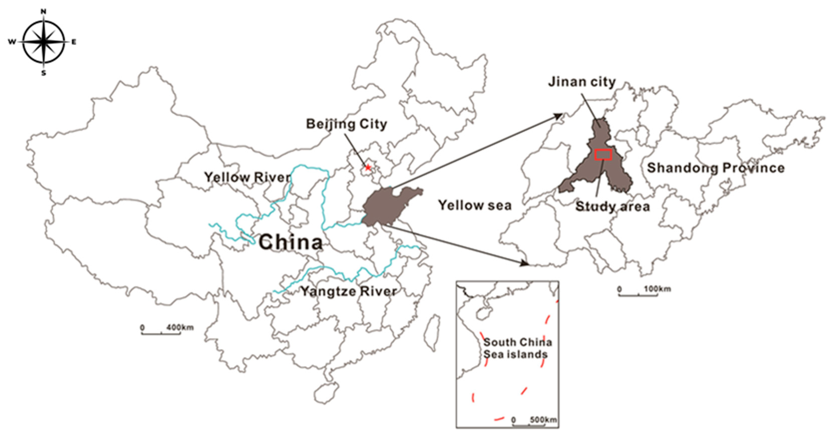
The Jinan karst spring area is located in the west-central part of Shandong Province, China, at a longitude of 116°40′–117°14′ E and a latitude of 36°14′–36°46′ N, which covers an area of about 1500 square kilometers (
Figure 1). Regarding the topography and geomorphology, the Jinan spring area is located in the conjunction of the Lunan low mountain hills and the Lubei alluvial flood plain. The southern part of the study area is Mount Tai, with the mountain range running east-west. The southern part of the study area is an inclined plain in front of the mountain, with the terrain high in the south and low in the north and with relative height differences over 500 m. From south to north, there are hills, hollows, pre-hill plains and yellow flood plains, in that order. Therefore, the basic path of the spring is laid down by these special topographical and geomorphological features.
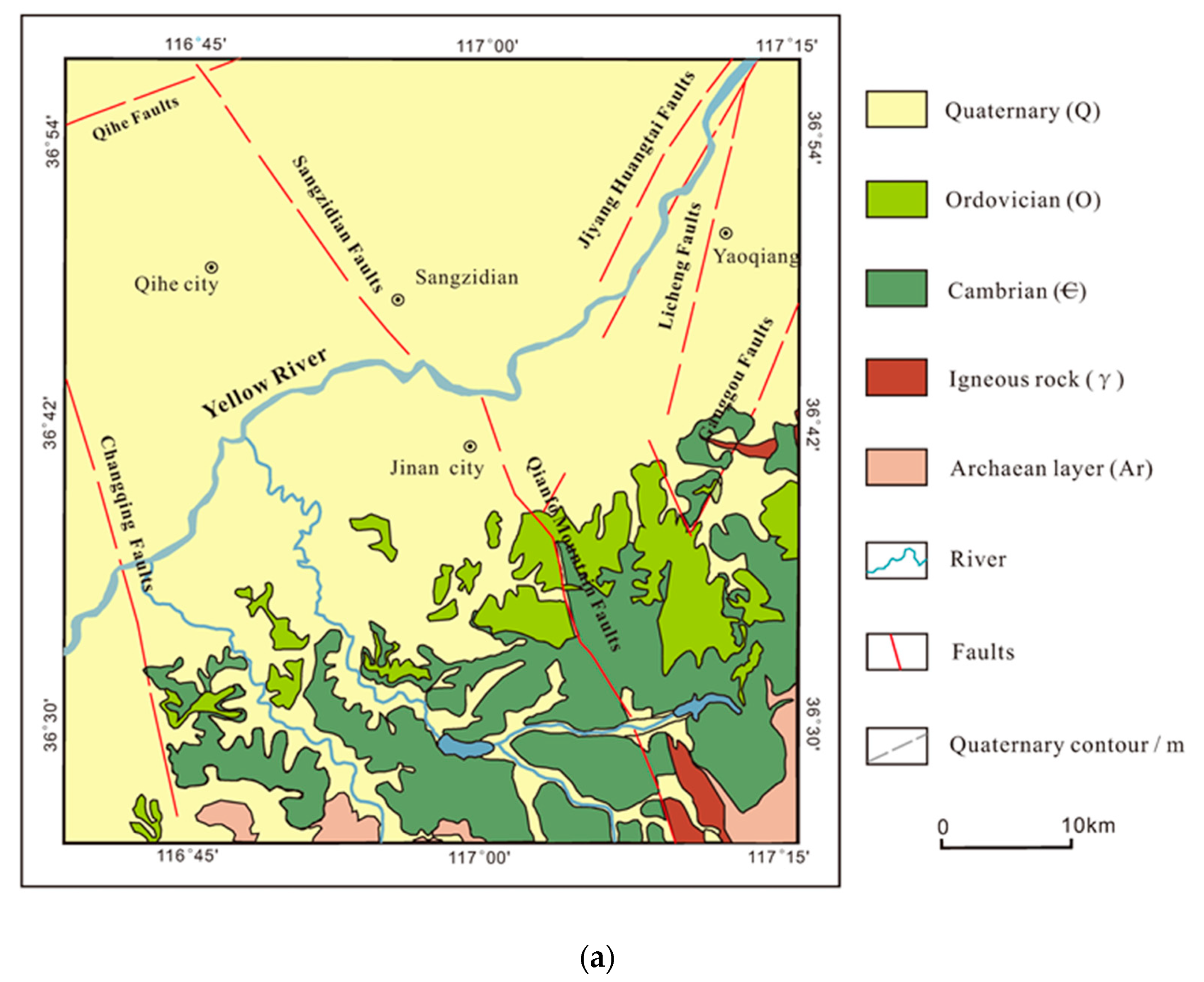
According to the characteristics of stratum lithology, water-bearing medium, groundwater movement and storage, the groundwater water-bearing rock group of the study area can be divided into the loose rock pore water-bearing rock group, carbonate rock fissure-karst water-bearing rock group, clastic rock with carbonate rock karst-fracture water-bearing rock group, metamorphic rock and magmatic rock-fracture water-bearing rock group (
Figure 2a). Among them, limestone karst is well developed and water-rich, which is the carrier of spring water infiltration, runoff and discharge [
20,
21].
Fracture structures are developed in this region. There are mainly two groups of north-northwest and north-northeast trending fractures. One is the north-northwest trending Qianfo Mountain Fault, Changqing Fault and Sangzidian Fault. The other is the north-northwest-trending Ganggou Fault and Licheng Fault (
Figure 2b) [
21]. The faults in the region are of hydraulic conductivity. The basement structures formed by the Qianfo Mountain Fault and the Culture Bridge Fault are the key to the formation of the four major spring clusters, as they create the conditions for spring gushing.
Jinan belongs to the zone of the warm temperate continental climate. The annual precipitation varies greatly in the spring area, with the maximum at 1164 mm (year 1964) and the minimum at 340 mm (year 1989). There is the Yufu River, Beisha River and Xiaoqing River within the spring area, among which the Yufu River is one of the important recharge sources of karst water [
22]. There is the Wohushan Reservoir, Jinxiuchuan Reservoir and Yuqinghu Reservoir, which play an important role in the water supply and farmland irrigation in Jinan City. At the same time, it is also of great significance for weakening flood, regulating runoff and recharging groundwater [
23].
The source of groundwater recharge in the Jinan spring area is mostly atmospheric precipitation. The direction of runoff is generally from south to north, controlled by topography. The main drainage methods of karst groundwater are artificial exploitation, spring drainage and karst water supply to Quaternary pores.
2.2. Causes of Spring Water
The springs in Jinan originate from the southern mountainous region, which is the result of the combination of topography, geomorphology, geological structure and meteorological conditions [
24]. The reasons for the formation of the karst spring areas in Jinan can be divided into the following four points:
The tendency of the strata is consistent with the inclination of the terrain, which is the geological and geomorphological basis for the formation of springs. The southern part of Jinan is a monoclinic tectonic area, and the rock strata tilt from south to north at an angle of 3 to 15 degrees. The monoclinic tectonics and the south high north low terrain are consistent, which lays a good geomorphological foundation for the movement of groundwater from south to north.
The southern mountainous area is densely planted, which can contain water and reserve a large amount of water.
The karst fissures of the huge thick limestone stratum are developed, which provide a good place and passage for the recharge, storage and transportation of karst groundwater.
The huge impermeable magmatic rocks in the north blocked the way of groundwater, and it is also crucial to the formation of Jinan spring water.
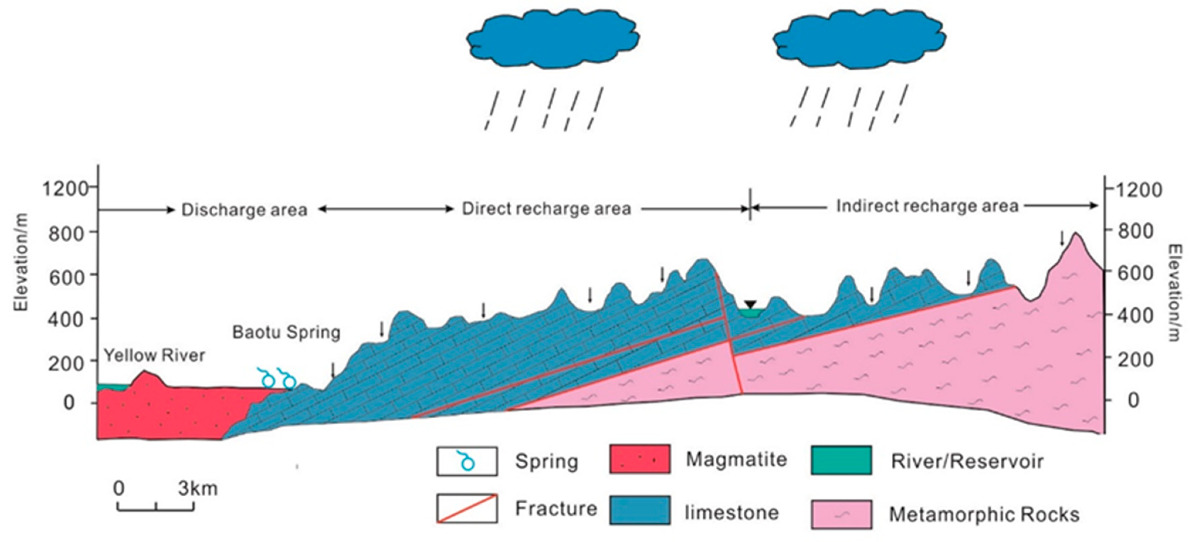
Specifically, as the recharge area of the Jinan spring, the tuff outcrops and fissure karst development in the southern mountainous area collect a large amount of atmospheric precipitation and surface runoff. Then, it infiltrates into the ground to form rich fissure karst water, but such fissure karst water cannot continuously infiltrate downward because of the blockage of the Archeaneon metamorphic rocks. The karst water moves horizontally from south to north along the inclination of the rock formation, forming an underground flow. The karst water moves horizontally from south to north along with the tendency of the rock formations, forming underground submerged flow. Due to the blockage of diorite and fault, a large amount of groundwater converges in the urban area. Then, the water flow moves vertically upward instead of horizontally, and the karst is extremely developed, which contributes to the rise of the groundwater level. Under the strong hydrostatic pressure, groundwater flows out of the surface through karst fissures and forms natural springs in the contact zone between the limestone and intrusive rock mass and the weak Quaternary sedimentary layer. For that reason, and as a matter of causes, the springs in Jinan City belong to the contact springs of igneous rock. In short, Jinan spring water mainly comes from the southern mountains, where atmospheric precipitation seeps underground and the terrain is high in the south and low in the north. Stored in the limestone of the southern mountains, karst water is blocked by impermeable magmatic rocks in the urban areas during runoff to the north. The confined groundwater is exposed to the surface and forms springs [
24,
25]. The cause of the Jinan springs is shown in
Figure 3.
3. Dynamic Survey and Analysis of Spring Water in Jinan
3.1. Dynamics of Spring Flow
Jinan is a water shortage city, and the ecological environment of the region is relatively fragile. Water resources are unevenly exploited, with surface water being less exploited but groundwater being more exploited. Since the 1980s and 1990s, a large number of groundwater resources have been exploited in the city and surrounding areas. The over-exploitation and utilization of groundwater have changed the original hydrodynamic field of groundwater and formed a regional groundwater level funnel. In addition, it also changes the recharge and discharge relationship between groundwater and surface water, leading to a series of environmental problems, such as the continuous decline of the regional groundwater level, the deterioration of water quality and the decay of spring flow.
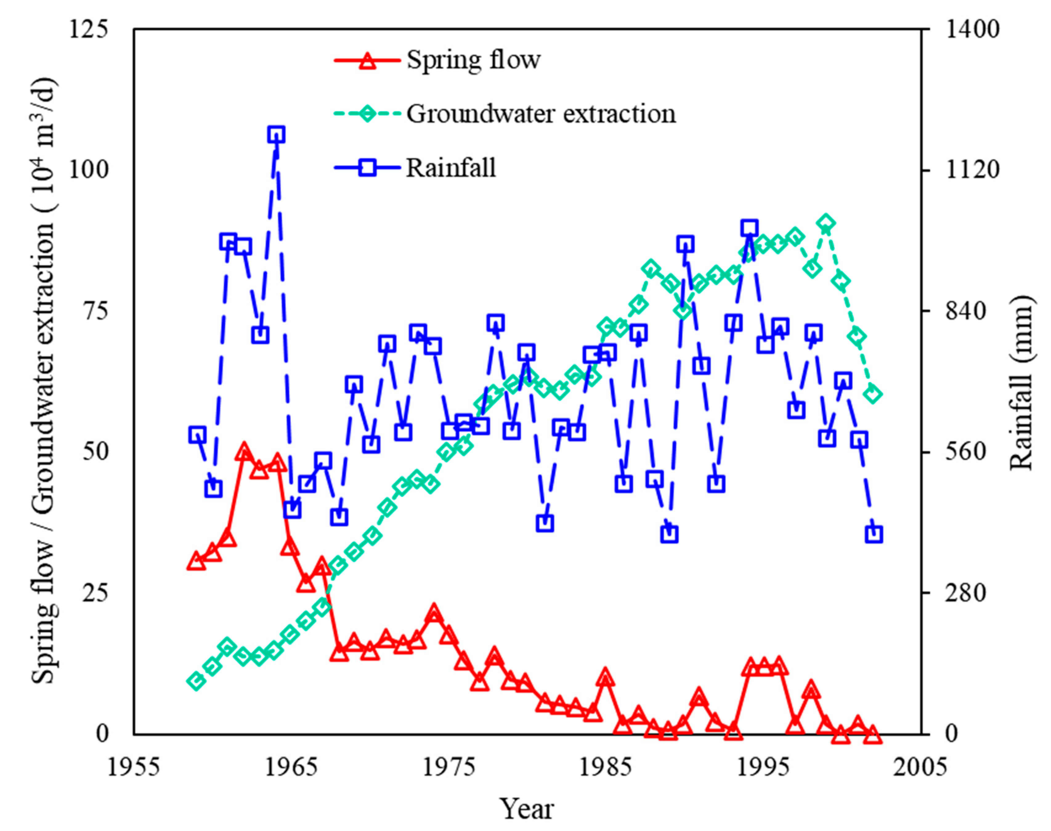
Figure 4 shows the spring flow, precipitation and groundwater extraction in the Jinan spring area during the period 1955–2005 [
25]. It can be found that the spring flow was kept at a high level during the period 1959–1967. The groundwater extraction in the Jinan spring area was low, and the rainfall was abundant; thus, the groundwater level was high and the springs gushed year-round. Especially in 1961–1964, the annual precipitation was more than 1000 mm. However, groundwater extraction has exceeded spring water flow since 1968. Since then, groundwater extraction has become the most important output item of Jinan’s karst water system. During 1968–1974, the groundwater level in the Jinan spring area was high, and the annual precipitation was stable between 550 and 750 mm. However, at the same time, groundwater extraction gradually expanded to 350,000–500,000 m
3/d, and the groundwater level in the urban area began to decline. The spring water flow decreased significantly compared with that before 1968, and even the Baotu spring dried up for the first time in June 1972.
After 1975, the impact of human activities on spring water and groundwater exploitation was increasing, while spring water flow was declining. During 1975–1999, although rainfall did not decrease significantly, groundwater exploitation amounted to 500,000–800,000 m3/d, resulting in medium-low groundwater levels in Jinan, with the annual average spring flow below 80,000 m3. The spring water has a seasonal or even long-term cutoff, sometimes lasting for as long as 3–8 months.
Since 2000, the Jinan government has restricted groundwater extraction by carrying out a series of measures to preserve the springs and has planted vegetation in the southern mountainous areas to contain the water. Jinan spring water gushed out again in 2003, but with the increasing demand for industrialization in recent years, the conflict between groundwater resource extraction and recharge has become increasingly prominent. The amount of groundwater extraction often breaks the balance. According to statistical analysis, the available groundwater extraction is about 98.55 million m
3 per year under the condition of maintaining normal and continuous gushing of springs, while the actual groundwater extraction exceeds this limit [
26]. For example, from 2012 to 2014, the three-year average extraction amount was about 119.33 million m
3, exceeding the limit by about 21%. Long-term overexploitation of groundwater deteriorates the fragile spring ecology; once the atmospheric precipitation decreases, the springs sustain gushing. During this period, the minimum groundwater level of the Baotu Spring was below 28.15 m (yellow alert level) and even below 27.6 m (red alert level) many times.
At the same time, the contradiction between the deteriorating groundwater quality and the optimal use of water is becoming more and more prominent. Due to the discharge of industrial wastewater and domestic sewage, the open dumping of garbage and the massive use of fertilizers and pesticides, the city’s annual wastewater discharge reaches 2.92 × 10⁸ m3. The surface water and groundwater are seriously polluted. The water quality of most reservoirs levels up from level II to level III, which indicates that the water quality has been slightly polluted. It should be noted that no reservoirs reach the standards of level I (good water quality), indicating that the quality of spring water is getting worse.
3.2. Reasons for and Analysis of Water Decay
The flow attenuation and water pollution of the Jinan spring are the results of the combined action of natural and human factors. The main natural factors are the infiltration of atmospheric precipitation. The human factors include the over-exploitation of groundwater, the construction of traffic projects that affect groundwater recharge and seepage and the development of southern mountainous areas that destroy water sources [
25,
27]. The specific reasons are as follows.
With the development of urbanization, the population and urban scale of Jinan are expanding, and the water demand has increased greatly. Compared with the surface water and Yellow River water, the groundwater in Jinan has excellent quality and a low treatment cost, so the water supply department prefers to exploit groundwater in the spring area to relieve the water supply tension. In recent years, the amount of groundwater extraction is shown in
Figure 4, which has led to the serious over-exploitation of groundwater in the downstream urban area of Jinan for several years, and the groundwater level continues to decline. With the Quancheng Square as the center, a huge groundwater over-exploitation leakage area has been formed. The unreasonable exploitation has destroyed the original groundwater flow field, and the decline in the groundwater level directly affects the spring gushing.
The development in the southern mountainous region has caused soil erosion and ecological damage of the upstream. The source is destroyed, and the capacity to contain water is decreased. The spring area in the southern mountainous area is about 1500 square kilometers, of which the key groundwater recharge area is nearly 200 square kilometers. In recent years, the forest vegetation in the southern mountainous region has been destroyed, which has significantly reduced the ability to store atmospheric precipitation and water conservation in the recharge area and has caused great damage to the water environment from the source. Various developments and construction activities are becoming more and more frequent in the southern mountainous areas, especially the construction of a large number of roads, resulting in a high degree of hardening of the ground surface, increasing the impermeable area and reducing the infiltration capacity of rainwater, which ultimately causes the discharge of a large amount of rainwater by surface runoff. In this condition, rainfall cannot smoothly infiltrate and recharge groundwater, seriously affecting groundwater recharge. The water cycle is disrupted, and groundwater is not effectively recharged.
In recent years, Jinan’s meteorological and hydrological conditions have changed dramatically. The climate is dry and the rainfall is reduced. Atmospheric precipitation infiltration is one of the important recharge sources of karst groundwater. Precipitation plays a controlling role in the total amount of water resources in karst springs. The main recharge of karst groundwater in Jinan comes from the atmospheric precipitation in the southern mountainous region. The decrease in precipitation directly affects the reduction in spring flow.
With the accelerated urbanization of Jinan, groundwater recharge is affected by the large number of projects built. In the process of urbanization, the new city in the east of Jinan has risen, and many commercial residential buildings, high-grade office buildings and other high-rise buildings have been built. For example, the 303-m Jinan Greenland Pulley Center, the 339-m Hanyu Golden Valley Main Building and the 259-m China Resources Center Main Building. The foundations of the tall buildings are deeply rooted in the ground, blocking the flow of underground springs and affecting the groundwater circulation to a certain extent.
4. Necessity and Progress of Jinan Rail Transit Construction
4.1. Traffic Congestion and the Necessity of Rail Transit Construction
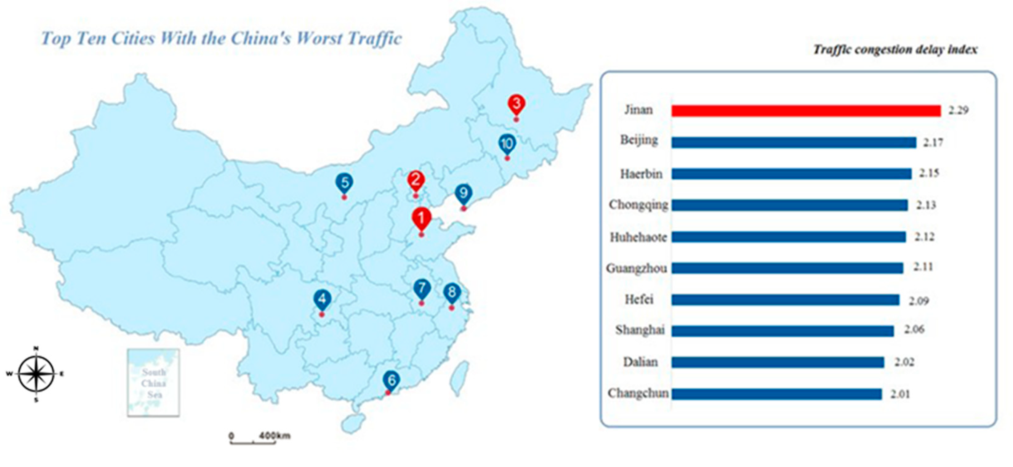
In recent years, the number of motor vehicles and drivers in Jinan has been growing rapidly. Traffic congestion has become one of the major problems affecting the image of the city and the life quality of residents and plaguing the development of the city. The congestion delay index is employed here to describe the degree of traffic congestion in Jinan. The congestion delay index equals the ratio of the time spent traveling during periods of traffic congestion to the time spent traveling when the traffic is clear. According to the 2017 Annual Traffic Analysis Report of Major Cities in China [
28] released by the Gaode Map Traffic Big Data Platform (GMTBDP), Jinan’s average commuter peak speed is 21.12 km/h, and Jinan’s peak congestion delay index reaches 2.29, ranking first in China (
Figure 5). In other words, the commuting time during congestion is about two times longer than the time when traffic is clear.
It can be found that the development of urban roads in Jinan seriously lags behind the growth of vehicles and traffic demand. In addition, due to automobile traffic congestion, it is necessary to develop urban rail transit construction. Thus, the city administration has decided to utilize subsurface transportation routes.
4.2. Progress of Rail Transit Construction
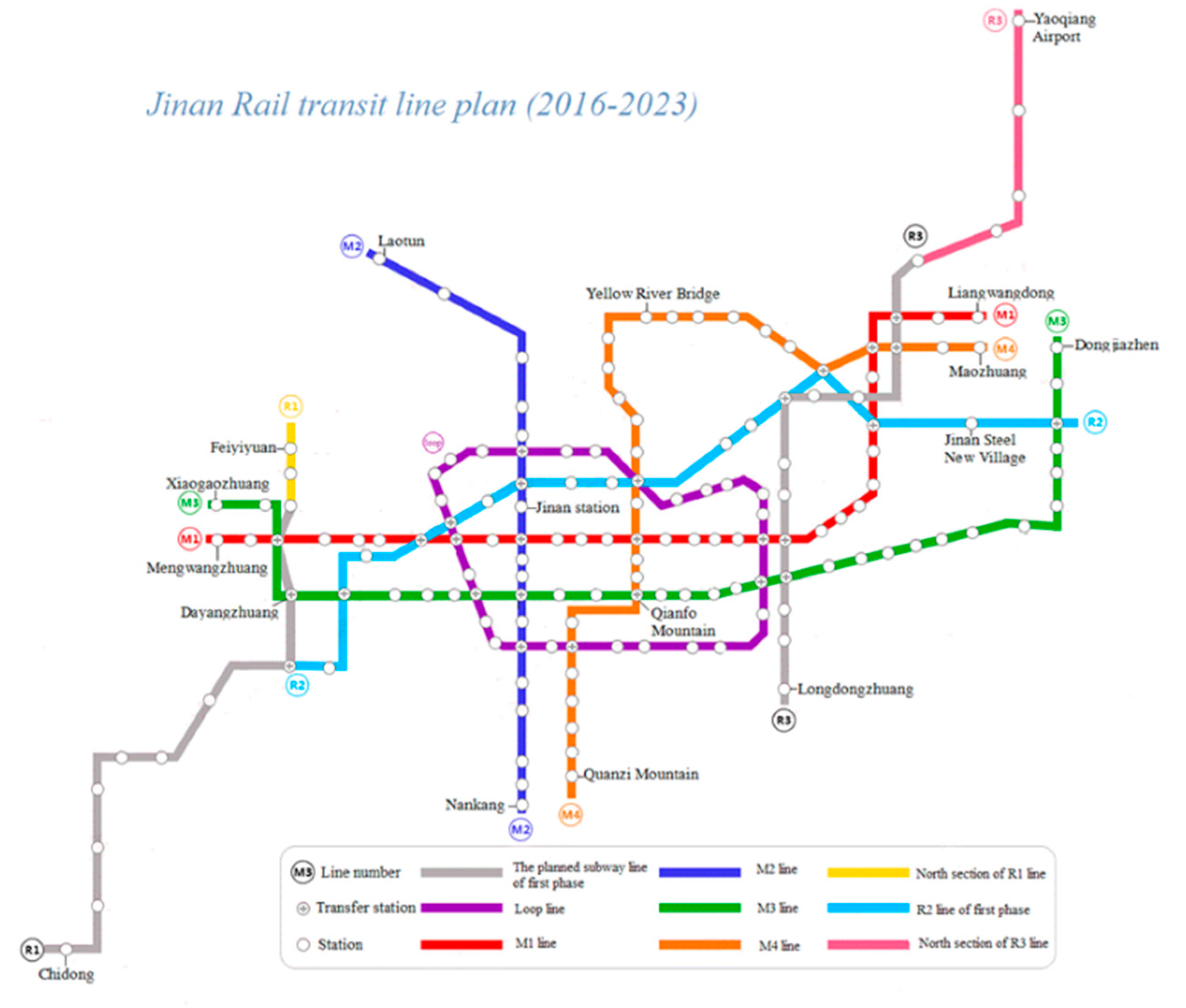
Since 2013, relevant traffic regulations have been introduced in Jinan one after another, and the recent construction plan of rail transit was made, which is shown in
Figure 6 [
29]. New urban rapid rail transit lines will be built. Specifically, the Jinan rapid rail transit line will be constructed in two phases, and the rail transit line network is divided into two levels: the urban rapid line and the urban ordinary line.
The first line, R1, was opened in April 2019, making Jinan the second city in Shandong Province to open a rail transit. With the construction of Jinan’s rail transit, the structure of the city road network will be optimized, the existing road traffic capacity and traffic travel structure will be improved and the traffic congestion will be relieved.
5. Potential Spring Damage Risks during Construction
There are various hidden dangers for the ecological environment and spring water protection of the karst spring area behind the vigorous development of the Jinan rail transit lines. It can be speculated that the construction of rail transit may threaten the spring ecology and change the groundwater hydrodynamic and hydrochemical conditions based on the studies of engineering geological surveys, hydrogeological surveys and geophysical surveys conducted in Jinan over the years. This will inevitably have an impact on the spring flow [
30,
31]. Based on the analysis of the geological and hydrogeological conditions and spring formation mechanisms in the Jinan area, the factor that has the greatest impact on spring outflow is whether the rail transit crosses the source channel of the spring, i.e., the karst aquifer. Due to the wide range of the study area, the different stratigraphic structures and geological formations traversed, the closeness of the spring connection in different regions and the influence of the rail transit line on the springs differ greatly.
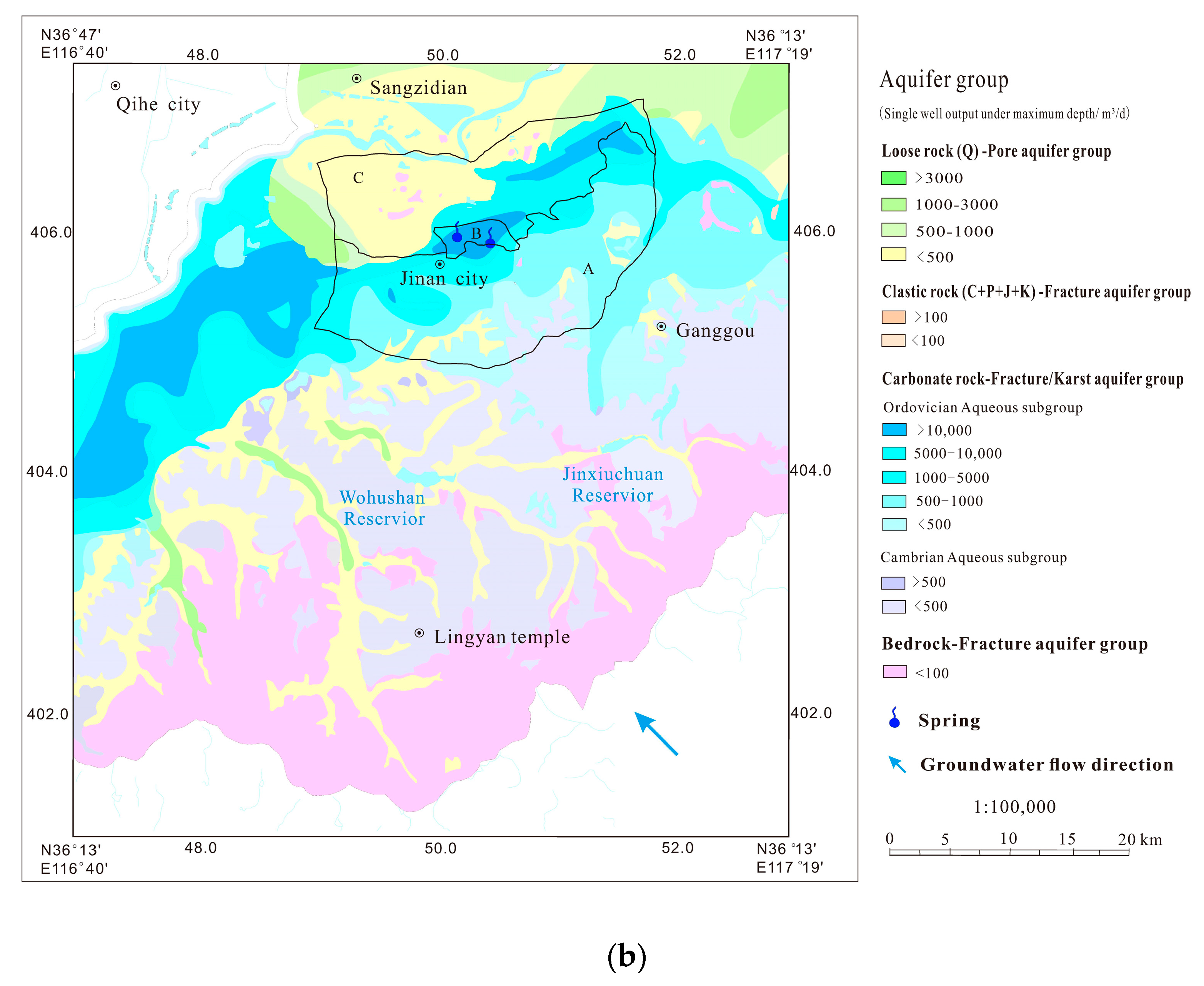
According to the different stratigraphic structure, limestone roof depth and karst water head depth, the Jinan spring area is divided into the shallow limestone area (Area A), concentrated spring water area (Area B) and deep limestone area (Area C) along the groundwater runoff direction in this paper (
Figure 2b). The shallow limestone area (Area A) in the southern mountainous region, located on the south of the concentrated outcrop area of the four major spring groups, is the direct recharge and runoff area of the springs. A large amount of atmospheric precipitation and surface runoff is collected in this area, and the groundwater infiltration forms rich fissure karst water. The stratigraphic structure of the shallow limestone area is limestone and the combination of limestone and Quaternary strata. Building a subway in this area will occupy part of the karst channel, which will affect the flow of spring water to a certain extent. However, due to the large depth to the karst water table in this area, the depth to the rail transit floor is higher than the karst water level. Considering that the depth of the underground structure in the rail transit is about 15 m, which is higher than the karst water level in the southern mountainous area during the abundant water period, the stable underground karst water source will not be touched by most underground construction works, and the karst spring gushing and spring ecosystem will not be affected.
It also can be found in
Figure 2b that Area B is a concentrated spring outcrop area, which is a sensitive area for spring protection. The geological structure of the area is highly variable and complex. The Quaternary strata, gabbro and limestone are distributed within 50 m underground. The karst water is buried at an extremely shallow depth, and the level in some areas is higher than the surface, with high head pressure, fissure karst development and strong water-richness. Therefore, the influence radius of engineering precipitation during the construction of the rail transit project may be greater. In addition, in the construction of underground projects of rail transit, karst water may be exposed by the subgrade of underground projects and tunnel leakage, and sudden water disasters may occur. New karst water discharge points will be formed, which may affect the spring gushing in serious cases. In the downstream of the runoff, Area C is mainly distributed as a deep limestone area, away from the spring concentrated discharge area. The top depth to limestone table in this area is generally greater than 50 m, and the shallow stratum is dominated by the combination of the Quaternary and magmatic rocks. Groundwater is dominated by shallow pore water, with a high karst water head. Most limestone buried depth in this area is lower than the average buried depth of the underground structure. Therefore, the possibility of encountering karst water is very small in the construction process. The recharge and runoff of spring water and spring water ecosystems are usually not affected.
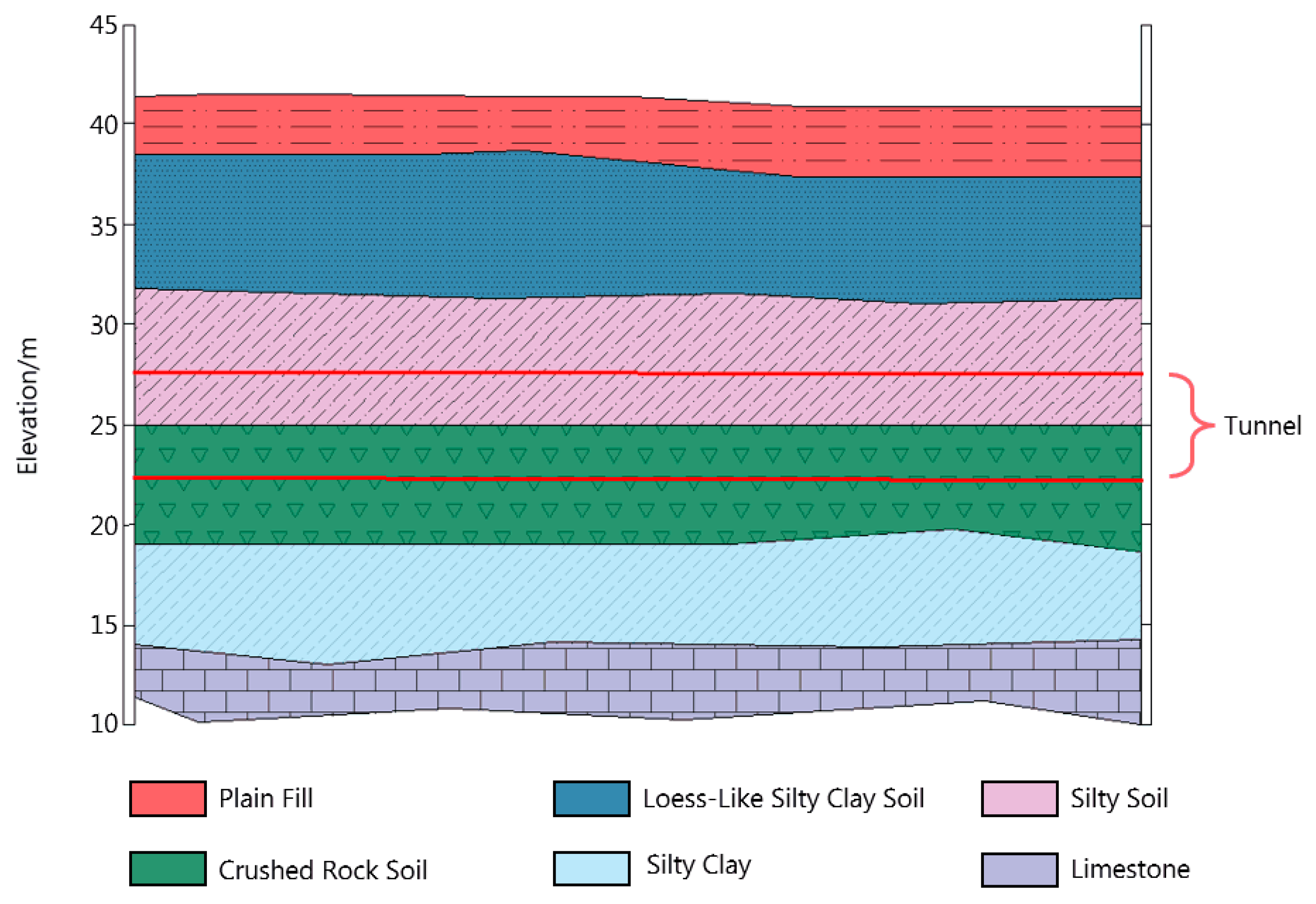
A typical example of a reasonable selection of buried depth of the underground structure can be seen in
Figure 7. It is noted that the floor of the subway tunnel should be higher than the limestone stratum. Under the guidance of this design criteria, the potential risks of water inrush [
32,
33] and tunnel boring machine jamming [
34] can be reduced. In addition, benefiting from the reasonable selection of burial depth shown in
Figure 7, the impact of construction on spring water will be reduced.
The quantitative estimation of the of spring flow rate affected by subway construction is an interesting point. The numerical simulation is an efficient approach to further explain how the subway construction affects the spring flows [
1]. A typical example of the impact of subway construction on the reduction of spring flow rate in Jinan can be found in Shu’s contribution [
19]. Their research object is the planned subway Line M1. The two different construction scenarios, including pumping and pumping with artificial recharge, were simulated in order to estimate the reduction in the flow rate of the Baiquan spring group (BSG) caused by subway construction. Their simulation-based results show that the simultaneous construction of several stations has the relatively greater impact on the spring flow, and the maximum attenuation is 5.48%. It is found that pumping construction with artificial recharge can effectively mitigate spring flow attenuation. The quantitative results obtained from the numerical simulations confirmed that the spring ecosystem can be harmonized with rail transit construction in Jinan city. In addition, it is recommended that the construction of underground structures should be reasonably sequenced to reduce the impacts of construction on spring flow.
In rail transit construction, large area artificial measures of lowering groundwater are often carried out to ensure the stability of the excavation face [
17,
35,
36]. This easily causes the groundwater ‘funnel’ water level to decline, thus changing the groundwater dynamic field and chemical field. Changes in some chemical components and microbial contents in groundwater lead to increased groundwater pollution and the deterioration of water quality. At the same time, chemical grouting reinforcement is often used in underground tunnel construction to improve the anti-seepage performance and increase the strength of the soil [
37,
38,
39]. However, the traditional grouting materials may lead to the deterioration of water quality. Thus, it is recommended to use the sustainable materials to avoid influencing groundwater quality in the spring areas. Moreover, groundwater quality will be affected by sewage and domestic sewage in rail transit construction. At the same time, chemical reactions may occur between groundwater and the track structures of underground railways during operation. In other words, groundwater erodes concrete structures and thus affects groundwater pollution.
6. Recommendations and Countermeasures
The conservation of karst springs is a complex system project involving many fields. It is difficult to solve the problem in a short period of time by taking only one measure. The core conflict of “spring protection” is between the rapid development of urbanization and the natural ecology of springs [
26]. In order to achieve sustainable spring gushing in Jinan, this paper proposes the following measures to protect the springs based on the previous analysis.
First of all, the key to spring conservation is to increase the amount of spring recharge and reduce the amount of spring discharge. On the one hand, in order to maintain the normal gushing of springs, the amount of groundwater extraction shall be reduced. On the other hand, in order to ensure healthy, sustainable and high-speed socio-economic development, it is necessary to continuously increase the amount of water supply. So, the contradiction between the two needs to be solved urgently. On the one hand, new Yellow River water sources must be opened up to replace groundwater. At the same time, artificial recharge and artificial rainfall are adopted as the emergency plan when the spring water is depleted. On the other hand, the amount of groundwater extraction should be reasonable and strictly controlled. The measures that can be taken at this stage include: optimizing the groundwater exploitation plan in Jinan city and its suburbs, changing the centralized exploitation to decentralized exploitation, adopting various water conservation measures, using water efficiently, advocating for water conservation, building water conservation projects and dredging rivers. This would be to transform the existing water supply network in Jinan, separate the operation of the residential water network from the urban and industrial water network and realize a separate water supply.
Moreover, the protection of the karst spring area should be further strengthened. The southern mountainous area of Jinan is the recharge area of the groundwater of the spring area. Therefore, it is necessary to strengthen ecological environmental protection and enhance the ability to contain water in this area. The construction of greening and soil conservation, the reinforcement of reservoirs and comprehensive river basin management are adopted to conserve groundwater sources and increase the recharge of spring sources. Further, to monitor the groundwater level, flow and water quality and to understand the dynamic changes of springs, a real-time dynamic monitoring system of groundwater in the spring area should be established. The groundwater resource evaluation of the spring area should be performed. In addition, a comprehensive “spring protection” law and regulations should be established to regulate water use, and a long-term management mechanism is suggested to be gradually established to strongly ensure the spring’s year-round gushing. A team of geologists, hydrogeologists and other professionals should be formed to answer questions and provide advice on the process of spring conservation.
Regarding Jinan rail transit construction, “spring protection takes precedence over subway construction” should be observed in the process of subway construction. In order to avoid the main spring seepage recharge channel and ensure that the rail transit structure is higher than the highest water level in 30 years, when encountering spring sensitive areas, the “bypass and lift” approach is taken. Moreover, in shallow karst water level areas, line lifting and shallow underground burial were adopted. According to the radius of the project precipitation impact, field recharge measures should be taken timely. In order to increase the recharge path, recharge tests were conducted to explore new techniques of artificial recharge. During the construction of rail transit, groundwater quality, water level and flow rate are monitored and evaluated in real time by the system, and dynamic hydrogeological data information is obtained so as to propose corresponding adjustment measures.
7. Conclusions
Behind the booming development of rail transportation in Jinan, various potential problems of spring ecology and spring protection have been revealed. In this paper, a comprehensive survey of the springs was carried out for the karst springs in Jinan. Based on the engineering geological and hydrogeological conditions in Jinan, the geological causes of springs were analyzed. Due to the high topography in the south and low topography in the north, the karst water that is stored and collected in the southern mountainous area is blocked by impermeable rock layers in the process of runoff to the north and exposed to the surface, thus forming springs. Combined with the dynamic survey of Jinan spring flow, the groundwater resources in the Jinan karst area are highly developed. Due to the combined effect of natural and human factors, the groundwater level in recent years is medium and low, and the decay of spring flow affects the continuous gushing of spring water.
To elaborate on the potential damage to spring water in the construction of underground engineering of rail transit, according to the different stratigraphic structure, limestone roof depth and karst water head depth, the Jinan spring area is divided into the shallow limestone area, concentrated spring water area and deep limestone area along the groundwater runoff direction. The shallow limestone area in the south provides the main supply of spring water. If the subway is built in this area, part of the karst channels will be squeezed and affect the spring flow to some extent. Considering that the burial depth of the rail transit floor is higher than the karst water level during the abundant water period, the impact on the spring ecosystem is relatively slight. The concentrated spring outcrop area in the city center is a sensitive area for spring protection where the density of underground pipelines is large and the depth of karst water is shallow. Because the groundwater level is higher than the surface in some areas and the radius of influence of the project precipitation is large, the construction pipeline floor is likely to expose karst water to form new karst water drainage points. The depth of the shallow limestone area is generally lower than the average depth of the underground structure of the track, so the possibility of exposing karst water is very small, with little impact on the recharge of springs and runoff and on spring ecosystems.
In order to protect Jinan’s urban karst water resources and keep Jinan’s spring water continuously gushing all year round, in addition to strengthening the protection of water sources in the southern mountainous areas and reducing groundwater exploitation, this study suggests that “spring protection takes precedence over subway construction“. The design of the line network should bypass the spring-sensitive areas and avoid the seepage recharge channel. Combined with the project precipitation leakage, field recharge measures should be taken in time to increase the recharge pathway. Real-time monitoring of the groundwater quality, water level and flow during the construction period is suggested to be further carried out, and dynamic hydrogeological data information should be grasped to properly assess the groundwater resources in the spring area.
Author Contributions
Data curation, W.W., K.L. and J.K.; Funding acquisition, X.W.; Investigation, W.W.; Methodology, W.W. and Y.F.; Validation, K.L., X.W. and J.K.; Writing—original draft, W.W. and Y.F.; Writing—review & editing, K.L. All authors have read and agreed to the published version of the manuscript.
Funding
This research is funded by the National Natural Science Foundation of China (Grant No.: 51879153).
Data Availability Statement
Data are contained within the article.
Acknowledgments
We would like to acknowledge the financial support from the National Natural Science Foundation of China (Grant No.: 51879153).
Conflicts of Interest
The authors declare that they have no known competing financial interest or personal relationship that could have appeared to influence the work reported in this paper.
References
- Xu, Z.; Pan, D.; Lin, P.; Zhang, Q.; Li, H.; Zhang, Y. Numerical investigation of flow control technology for grouting and blocking of flowing water in karst conduits. Int. J. Numer. Anal. Methods Geomech. 2021, 45, 1712–1738. [Google Scholar] [CrossRef]
- Jiang, G.; Guo, F.; Polk, J.S.; Kang, Z.; Wu, J. Delineating vulnerability of karst aquifers using hydrochemical tracers in Southwestern China. Environ. Earth Sci. 2015, 74, 1015–1027. [Google Scholar] [CrossRef]
- Zhang, Z.; Wang, W.; Qu, S.; Huang, Q.; Liu, S.; Xu, Q.; Ni, L. A new perspective to explore the hydraulic connectivity of karst aquifer system in Jinan spring catchment, china. Water 2018, 10, 1368–1389. [Google Scholar] [CrossRef] [Green Version]
- Zhou, Y.; Gao, Z. Groundwater Quality Monitoring Network for Jinan Karst Spring Catchment, China; International Symposium on Water Resource & Environmental Protection: Xi’an, China, 2011; pp. 44–47. [Google Scholar] [CrossRef]
- Spellman, P.; Gulley, J.; Martin, J.B.; Loucks, J. The role of antecedent groundwater heads in controlling transient aquifer storage and flood peak attenuation in karst watersheds. Earth Surf. Process. Landf. 2019, 44, 77–87. [Google Scholar] [CrossRef] [Green Version]
- Bittner, L.; England, S.; Murray, C.; Mirecki, J.; Richardson, E.; Brown, C.; Kaiman, B. Development of a new model tool for evaluating groundwater resources within the Floridan Aquifer System in Southern Florida, USA. Environ. Earth Sci. 2017, 76, 1–15. [Google Scholar] [CrossRef]
- Martin, J.B.; Dean, R.W. Exchange of water between conduits and matrix in the Floridan aquifer. Chem. Geol. 2001, 179, 145–165. [Google Scholar] [CrossRef]
- Perrin, J.; Pochon, A.; Jeannin, P.Y.; Zwahlen, F. Vulnerability assessment in karstic areas: Validation by field experiments. Environ. Geol. 2004, 46, 237–245. [Google Scholar] [CrossRef] [Green Version]
- Screaton, E.; Martin, J.B.; Ginn, B.; Smith, L. Conduit properties and karstification in the unconfined Floridan Aquifer. Ground Water 2004, 42, 338–346. [Google Scholar] [CrossRef]
- Chakraborty, J.; Varonka, M.; Orem, W.; Finkelman, R.B.; Manton, W. Geogenic organic contaminants in the low-rank coal-bearing Carrizo-Wilcox aquifer of East Texas, USA. Hydrogeol. J. 2017, 25, 1219–1228. [Google Scholar] [CrossRef] [Green Version]
- Hudak, P.F. Nitrate Concentration Patterns over Space and Time in a Regionally Sloping Sedimentary Aquifer, Texas, USA. Bull. Environ. Contam. Toxicol. 2018, 100, 416–420. [Google Scholar] [CrossRef]
- Biondic, B.; Biondic, R.; Dukaric, F. Protection of karst aquifers in the Dinarides in Croatia. Environ. Geol. 1998, 34, 309–319. [Google Scholar] [CrossRef]
- Matiaki, M.C.; Siarkos, I.; Katsifarakis, K.L. Numerical modeling of groundwater flow to delineate spring protection zones. The case of Krokos aquifer, Greece. Desalination Water Treat. 2016, 57, 11572–11581. [Google Scholar] [CrossRef]
- Goldscheider, N. Karst groundwater vulnerability mapping: Application of a new method in the Swabian Alb, Germany. Hydrogeol. J. 2005, 13, 555–564. [Google Scholar] [CrossRef]
- Goldscheider, N.; Klute, M.; Sturm, S.; Hotzl, H. The PI method—A GIS-based approach to mapping groundwater vulnerability with special consideration of karst aquifers. Z. Angew. Geol. 2011, 46, 157–166. [Google Scholar]
- Perez, J.J.; Sanz, E. Hydrodynamic characteristics and sustainable use of a karst aquifer of high environmental value in the Cabrejas range (Soria, Spain). Environ. Earth Sci. 2011, 62, 467–479. [Google Scholar] [CrossRef]
- Pan, D.; Li, S.; Xu, Z.; Zhang, Y.; Lin, P.; Li, H. A deterministic-stochastic identification and modelling method of discrete fracture networks using laser scanning: Development and case study. Eng. Geol. 2019, 262, 105310. [Google Scholar] [CrossRef]
- Wang, Q.; Gao, H.; Jiang, B.; Li, S.; He, M.; Qin, Q. In-situ test and bolt-grouting design evaluation method of underground engineering based on digital drilling. Int. J. Rock Mech. Min. Sci. 2021, 138, 104575. [Google Scholar] [CrossRef]
- Shu, L.; Wang, X.; Li, H.; Ni, H.; Li, G.; Yu, Y.; Wang, X.; Zhang, M. Impact of subway construction on flow of Baiquan Spring Group in Jinan. J. Jilin Univ. (Earth Sci. Ed.) 2021, 51, 192–200. [Google Scholar]
- Qian, J.; Zhan, H.; Wu, Y.; Li, F.; Wang, J. Fractured-karst spring-flow protections: A case study in Jinan, China. Hydrogeol. J. 2006, 14, 1192–1205. [Google Scholar] [CrossRef]
- Wang, X.; Yang, W.; Xu, Z.; Hu, J.; Xue, Y.; Lin, P. A Normal Cloud Model-Based Method for Water Quality Assessment of Springs and Its Application in Jinan. Sustainability 2019, 11, 2248. [Google Scholar] [CrossRef] [Green Version]
- Zhang, Z.; Liu, Y.; Zhang, F.; Zhang, L. Study on dynamic relationship of spring water in Jinan spring area based on gray relational analysis. In Proceedings of the 3rd International Conference on Energy Equipment Science and Engineering (ICEESE), Beijing, China, 28–31 December 2018. [Google Scholar]
- Zhou, J.; Xing, L.; Zhang, F.; Han, Z.; Peng, T.; Xu, M.; Yang, Y. Chemical Characteristics Research on Karst Water in Jinan Spring Area. Adv. Mater. Res. 2015, 1092, 593–596. [Google Scholar] [CrossRef]
- Liu, L.; Song, S.; Cui, C. Research on the genesis of Jinan spring water and countermeasures for spring protection. Shandong Water Conserv. 2013, 5, 17–18. [Google Scholar]
- Wang, M.; Shu, L.; Ji, Y.; Tao, Y.; Dong, G.; Liu, L. Cause analysis and dynamic simulation of water flow attenuation in Jinan karst spring. Carsologica Sin. 2008, 27, 19–23. [Google Scholar]
- Liu, L. Summary and Research on Technical Measures and Management Measures of Spring Protection in Jinan Spring Area. Master’s Thesis, Shandong University, Jinan, China, 2011. [Google Scholar]
- Zheng, L. Research on Evaluation Index System of Water Resources Management and Protection in Karst Springs. Master’s Thesis, China University of Geosciences (Beijing), Beijing, China, 2011. [Google Scholar]
- Gaode Map Traffic Big Data Platform (GMTBDP). Traffic Analysis Report of China Major City in 2017. Available online: https://report.amap.com/ (accessed on 17 April 2018).
- Jinan Rail Transit Group Co., Ltd. The Construction Plan for Jinan City Urban Rail Transit Project. Available online: https://www.jngdjt.cn/ (accessed on 13 April 2016).
- Jin, H.; Huang, F.; Liu, Y.; Pang, W.; Feng, K. The Impact of Jinan Rail Transit Construction on Spring Water Ecosystem. Urban Rapid Transit. 2010, 23, 31–35. [Google Scholar]
- Yang, L.; Han, W.; Yan, Z.; Liu, C.; Shang, H. Study on the impact of major engineering construction on Jinan spring water. Eng. Investig. 2012, 40, 42–48. [Google Scholar]
- Xu, Z.H.; Wang, W.Y.; Lin, P.; Nie, L.C.; Wu, J.; Li, Z.M. Hard-rock TBM jamming subject to adverse geological conditions: Influencing factor, hazard mode and a case study of Gaoligongshan Tunnel. Tunnel. Undergr. Space Technol. 2021, 108, 103683. [Google Scholar] [CrossRef]
- Xu, Z.; Pan, D.; Li, S.; Zhang, Y.; Bu, Z.; Liu, J. A grouting simulation method for quick-setting slurry in karst conduit: The sequential flow and solidification method. J. Rock Mech. Geotech. Eng. 2022, 14, 423–435. [Google Scholar] [CrossRef]
- Lin, P.; Yu, T.; Xu, Z.; Shao, R.; Wang, W. Geochemical, mineralogical, and microstructural characteristics of fault rocks and their impact on TBM jamming: A case study. Bull. Eng. Geol. Environ. 2022, 81, 1–9. [Google Scholar] [CrossRef]
- Li, S.; Pan, D.; Xu, Z.; Lin, P.; Zhang, Y. Numerical simulation of dynamic water grouting using quick-setting slurry in rock fracture: The Sequential Diffusion and Solidification (SDS) method. Comput. Geotech. 2020, 122, 103497. [Google Scholar] [CrossRef]
- Pan, D.; Xu, Z.; Lu, X.; Zhou, L.; Li, H. 3D scene and geological modeling using integrated multi-source spatial data: Methodology, challenges, and suggestions. Tunnel. Undergr. Space Technol. 2020, 100, 103393. [Google Scholar] [CrossRef]
- Wang, G.F.; Lyu, H.M.; Shen, J.S.; Lu, L.H.; Li, G.; Arulrajah, A. Evaluation of environmental risk due to metro system construction in Jinan, China. Int. J. Environ. Res. Public Health 2017, 14, 1114. [Google Scholar] [CrossRef] [PubMed] [Green Version]
- Mu, W.; Wang, D.; Li, L.; Yang, T.; Feng, Q.; Wang, S.; Xiao, F. Cement flow in interaction rock fractures and its corresponding new construction process in slope engineering. Constr. Build. Mater. 2021, 303, 124533. [Google Scholar] [CrossRef]
- Xu, Z.; Lin, P.; Xing, H.; Pan, D.; Huang, X. Hydro-mechanical Coupling Response Behaviors in Tunnel Subjected to a Water-Filled Karst Cave. Rock. Mech. Rock. Eng. 2021, 54, 3737–3756. [Google Scholar] [CrossRef]
| Publisher’s Note: MDPI stays neutral with regard to jurisdictional claims in published maps and institutional affiliations. |
© 2022 by the authors. Licensee MDPI, Basel, Switzerland. This article is an open access article distributed under the terms and conditions of the Creative Commons Attribution (CC BY) license (https://creativecommons.org/licenses/by/4.0/).


