The Evolving Structure of Rural Construction Land in Urbanizing China: Case Study of Tai’an Prefecture


1
School of Geography, Faculty of Geographical Science, Beijing Normal University, Beijing 100875, China
2
College of Urban and Environmental Sciences, Peking University, Beijing 100871, China
3
Center for Urban Future Research, Peking University, Beijing 100871, China
*
Author to whom correspondence should be addressed.
Land 2021, 10(1), 65; https://0-doi-org.brum.beds.ac.uk/10.3390/land10010065
Submission received: 27 November 2020
/
Revised: 7 January 2021
/
Accepted: 11 January 2021
/
Published: 13 January 2021
(This article belongs to the Section Land Socio-Economic and Political Issues)
Abstract
:With a rapid surge in urbanization, rural functions and the structure of rural construction land are undergoing profound change. Using the village-level units of Tai’an Prefecture in the North China Plain as the research object, this study employs the land use survey data in 2019, selecting the diversity index, concentration index, land use type, and location index to analyze the spatial pattern of rural construction land structure. Thereafter, a multiple linear regression model is developed to identify the driving factors of spatial differentiation in rural construction land structure. The results show that (1) there are remarkable spatial differences in all indices representing the structure of construction land in Tai’an and the landscape varies across the indices, and (2) the most important factors affecting the spatial differentiation of construction land use structure are the location, socioeconomic development, and policy, while the effects of natural conditions are limited. The worse the location conditions and the more regressed the economic and social development level, the lower the diversity of construction land and the more unitary the structure. The results of this case study demonstrate the crucial role of the changing urban–rural relation under rapid urbanization in shaping the geography of rural land use, which is expected to have reference significance for researchers and policy makers dealing with rural transformation in developing countries.
1. Introduction
With the rapid surge in urbanization, rural areas are globally in decline. Rural recession is manifested in the loss of rural farmland, population decline, economic depression, and many other phenomena [1,2,3]. In contrast to the city, the countryside is not only a guaranteed space for urban food supply but also an important open space for many rural residents to live in traditional agricultural and cultural reservations while maintaining urban and rural ecological security [4]. Faced with the widespread problem of rural recession, the demand for rural revival, rebirth, or reconstruction is getting stronger [5,6]. Since 1990, rural areas worldwide have been undergoing economic, social, and environmental transformations involving land, population, and industries [7]. Meanwhile, the function of rural areas has shifted from traditional agricultural production, and the residential function of the rural population has diversified into non-agricultural roles [8]. The diversification of rural functions has gradually become a new trend in rural development worldwide. However, in the process of rural functional diversification, there are obvious spatial differences in the degree of economic and social development and the extent of diversification transformation because of regional differences in rural development conditions [9]. Due to the influence of economic radiation and social development of the city, rural areas around big cities experience rapid urbanization and economic and social transformation, and the rural economy undergoes rapid growth. However, remote rural areas, far from big cities, face population loss, economic recession, and economic and social marginalization [10,11]. Discussions around the existing problems and influencing factors of rural development in different regions and how to advance targeted rural governance policies have become important issues of concern for governments and researchers in many countries [12,13].
Since its market economy reforms, China has also experienced rapid urbanization. The urbanization rate has increased from 36% in 2000 to 60% in 2019. Many people have migrated from rural to urban areas. Rapid urbanization leads not only to the rapid expansion of cities but also to the loss of rural populations and the decline of the rural economy and society, resulting in a series of “rural diseases” such as “desertion,” “empty waste,” and “scattered and disorderly village construction” [14]. The development of rural areas faces a series of challenges such as industrial structural adjustment, economic transformation, social reconstruction, and landscape reshaping [15]. Although some villages are constantly enriching their functions in the process of transformation, and have a good development trend, more of them have been continuously experiencing the outflow of population and resources in the process of urbanization. The mainstream of rural change is declining and the dominant trend of the urban–rural relation is divergence. This is also the main reason why the central government put forward the strategy of rural revitalization which aimed at facilitating economic, societal, cultural, and governance improvement in rural areas, promoting urban–rural coordinated development, and narrowing the urban–rural gaps. Rural construction land is the container of rural non-agricultural function development, and its use structure reflects regional social and economic development. It is the core manifestation of the spatial distribution of regional functional elements such as rural residence, service, and transportation [15]. It is also the most visual part of the rural functional transformation [8]. Therefore, we selected a rapidly urbanizing prefecture in the North China Plain as the research area, analyzing the spatial distribution characteristics of the construction land structure of villages in different locations and the influencing factors of this spatial differentiation. This study is of great significance to achieving a deeper understanding of the impact of urbanization on rural economic and social transformation, functional reconstruction, rural revitalization, and rural sustainable development.
Research on rural land use structure and its changes can be of two types. For one, many studies have explored the impact of urban development on rural land use and cover changes. These studies have examined the encroachment of agricultural and ecological land on surrounding rural areas through urban expansion, the impact of urbanization on rural land use patterns, and the changes in rural agricultural and ecological land changes and their influencing factors, among other aspects [8,15,16,17]. These studies mainly used remote sensing images of different resolutions from varying regional scales, including country, region, province, city, and county levels, or used transects to study land use cover changes in rural areas [16,18,19,20]. The research reflects the spatial characteristics of changes in land use and cover in rural areas, during the process of urbanization, and deepens our understanding of rural land use changes. However, these studies neglected the structural changes of rural construction land within rural settlements when discussing land use changes, despite rural settlements being central to residents’ economic and social activities [21]. The spatial differences and changes in rural construction land structure within rural settlements reflect the spatial difference of rural functions and their transformation and reconstruction. Therefore, studying rural land use changes simply from the perspective of land cover cannot truly reflect the spatial distribution characteristics and differences in rural function and the economic and social transformations during rapid urbanization. For that, it is necessary to further explore the spatial differences and changes in the construction land structure of rural settlements.
To counter these shortcomings in rural land use structure research, many studies chose the second type of research, the case study method, using typical villages as their research objects [21,22,23]. They analyzed the spatial distribution characteristics and changes in construction land structure from a micro perspective, attempting to outline the influencing factors of rural land changes in the process of rural function transformation and reconstruction. The village is considered the basic unit of social and economic activity in China’s rural areas. Only by analyzing the construction land structure, with the village as a unit, can the essential characteristics of the rural function transformation be discovered [24]. This type of research offers many empirical examples of the transformation of rural functions and changes in land use structure, which can help us identify the micro-development and transformation patterns of land use in specific types of villages [9]. Despite these advantages, the case study method is limited by the conditions of the selected research area; a theoretical consensus is still elusive [25]. Thus, it is difficult to expound comprehensively and systematically on the spatial differences in the impact of cities on villages located at different distances. Whether the selected cases of this type of research are typical is also debatable [25], raising questions such as, what is the structure of construction land use in villages at various distances from the city? What are the spatial differentiation laws of the construction land structure in different villages? Are rural construction lands, with better location conditions and a higher degree of non-agriculturalization, structurally more balanced and diverse? These issues must be discussed in depth.
Given the shortcomings of both types of research, this study selected a prefecture-level city in the North China Plain—Tai’an Prefecture—as the research area and used more than 3495 villages in the region as the research object. Data from the latest land use survey were combined with the social and economic statistical data of each village. The village serves as a research unit to explore the spatial distribution characteristics and influencing factors of the construction land structure within rural settlements in China during the rapid urbanization phase. The following two issues are discussed. First, with villages as the research unit, the 2019 land use survey data are used to analyze the spatial distribution characteristics and spatial differences of the construction land structure within rural settlements by selecting multiple indicators such as diversity, concentration, and location quotient. Second, an analysis is conducted on the factors influencing spatial differences in the construction land structure within rural settlements. By analyzing spatial differences in the Tai’an Prefecture, this study reveals the influencing mechanism of rural construction land structure change against the background of rapid urbanization in China and provides important theoretical and practical reference for the regulation and management of rural land development in other Chinese regions and developing countries.
This article is organized as follows: Section 2 discusses the background of China’s rural transformation and the analysis framework for the paper; Section 3 reviews the elaboration of the research area, data, and methods; Section 4 presents the research results; and Section 5 provides the research conclusions and discussion.
2. Background and Analysis Framework
2.1. Research Background
As the main paths to economic and social modernization, industrialization and urbanization have brought unprecedented change to rural areas, changing the composition of the rural population, industrial structure, and rural production and lifestyle [26,27]. In traditional agricultural societies, agricultural production and rural living play a vital role, and the main function of the village is to provide space for rural agricultural production and human life [28,29]. As the city spreads, the countryside is gradually shaped by urban expansion. This impact is reflected not only in the expansion of land but also in the transfer of urban functions [8,30]. Rural areas have undergone drastic reconstruction and functional transformation. The diversity of rural functions and transformation as a result of industrialization and urbanization occurs in developed as well as developing countries [31,32]. Many studies have discussed the migration of rural populations, urban suburbanization, counter-urbanization, rural transformation, and rural function changes in the process of rural revitalization [33,34,35,36]. These studies have important reference values for rural transformation and development in China.
Similar to developed, industrialized, and urbanized countries, China’s rural areas are undergoing drastic transformation due to China’s rapid industrialization and urbanization. China has a large population, weak rural foundation, poor agricultural foundation, and large urban–rural gap. The dual system of urban–rural separation and the strategy of prioritizing urban development have led to the accumulation of many production factors such as labor, land, and capital in cities, restricting the sustainable development of rural areas and causing increasingly severe “rural diseases” [37]. Since its market economy reforms, China has experienced rapid economic development. In response to the problems in the countryside, China planned a series of macro-development strategies for urban and rural development, new rural construction, urban–rural integration, and new urbanization [17,37,38,39]. However, the long-term strategic path of “focusing on cities over townships” and the resulting “urban progress and village decline” remain unchanged; the overall effect of the implementation of the policy is still not clear, and some contradictions and problems remain [38,39]. To solve the increasingly serious rural dysfunction, the 19th National Congress of the Communist Party of China (CPC) in 2017 proposed the implementation of a rural revitalization strategy. The CPC Central Committee and the State Council issued “Opinions on the Implementation of the Rural Revitalization Strategy”. A “National Rural Revitalization Strategic Plan (2018–2022)” was proposed to adopt different methods for different types of villages in accordance with the village’s conditions, public opinion, scientific planning, focus on quality, and steady promotion of rural revitalization [39]. Overall, current rural revitalization planning research is still being explored in depth and there are few systematic research results and cases that can meet the actual needs of the vigorous rural revitalization plan.
The differences in regional development conditions and processes, the diversification of regional development goals, the diversity of social needs, and the versatility of land use lead to multiple functional types of villages and significant differences among regional spaces [40]. To promote the healthy development of these rural spaces and the orderly development and transformation of regional rural areas, targeted implementation of spatial control, guidance, and regulation is critical. This makes an in-depth study on the heterogeneity of rural spatial patterns and the division of rural spatial function types in the process of rural transformation important [41]. With the transformation of rural society and economy, the function and structure of rural construction land have undergone tremendous change. Changes in rural construction land is one of the most intuitive expressions of rural functional transformation. In recent years, changes in the quantity and structure of rural land due to urbanization and industrialization have received extensive attention [31,42].
2.2. Analysis Framework
Rural development and transformation are jointly influenced by external and endogenous factors, including natural conditions, location, economic, and social factors. There are different rural development modes and construction land use modes, driven by internal and external factors.
The influence of the natural environment on the region is often a slow process of accumulation but a fundamental constraint factor as well. Unlike cities, rural development is constricted by natural conditions, including topographic conditions, temperature, precipitation, farmland quality, and the ecological environment [43]. China’s traditional rural society is based on agriculture and allied activities, and is self-sufficient in daily life, work, and social facilities; the majority of the villagers are farmers. Since public facilities such as kindergartens, supermarkets, and factories, common in cities, are rare in rural areas, rural construction land is dominated by residential buildings with low functional diversity; land use, too, is dominated by housing [28,29,44]. The better the natural conditions, the more favorable the rural areas are for agricultural production, and the more people the land can feed. The agglomeration of a population often leads to the improvement and enrichment of rural functions, resulting a more complex structure of rural construction land.
However, with the development of the social economy, especially the advancement of urbanization and industrialization, social and economic factors are playing an increasingly important role, and the roles of relevant factors in the transformation and differentiation of rural functions have significantly strengthened [45]. Cities and villages have established a close relationship through the interdependence of space and function [46]. Therefore, urban expansion, which influences the functions of rural areas on the urban fringe, should be a basic factor in the transformation of rural functions [8].
The local conditions of the countryside are the main factors influencing the effects of urban radiation. The urban space of most cities in China is expanding in a “big pie” manner, and the urbanization gradient is widespread [47,48,49]. Therefore, the degree of rural transformation may differ depending on the level of urbanization. Rural areas located in suburban areas or transportation hubs and arterial areas are experiencing the most rapid development and can quickly adapt to the changes of the new economic and political environment and receive economic and functional radiation from the city [50]. Areas with better peripheral location conditions are preferred for the migration of urban industries and functions. In urban fringe areas with better geographical conditions, township enterprises and rural diversified operations have developed rapidly. The rural economy has completely eliminated single agricultural production. The level of rural non-agricultural activity has risen rapidly, the economic structure has undergone significant changes, and the industrial structure has begun to diversify. However, marginal rural areas are disadvantaged in benefitting from the city’s economic and functional radiation because of the lack of convenient interaction and material and information exchanges with the city. This is one of the most important factors which has led to the differentiation of rural function. Meanwhile, in recent years, multi-center network organization has become the main feature of the internal spatial relationship of urban areas [49,51]. As the most basic administrative unit, villages are affected by multi-level administrative governance and receive radiation from multi-level governments. Therefore, when considering villages’ functional transformation, we should also consider their interaction with multiple levels of government.
Economic factors also have an important impact on rural development and transformation. With urbanization, traditional rural economic factors (i.e., labor force, land) have been shifting to cities. Simultaneously, the constant reform and upgrading of the urban industrial structure promotes rapid economic development and expansion, spatially manifesting in the replacement and upgrading of leading industries. Urban populations, industry, employment, housing, and corresponding service facilities too are shifting to the suburbs [52]. Rural areas are undergoing industrial transformation, providing alternative livelihoods to agriculture, and their economic structures, production, and lifestyles are diversifying to meet the needs of local residents. Rural functions have also undergone significant change [53].
Social factors are more related to the endogenous factors of rural functional transformation. As their living conditions improved, rural residents needed more private and professional services such as improved medical services, education, and commercial leisure services. Servicing these needs allows businesses and service facilities to flourish. Cheap products and services in rural areas meet local needs and even attract customers from other areas [54]. However, the rural land use structure should first meet the production and living needs of its residents. As the active subjects of the evolution of rural function, rural residents’ residential preferences, employment choices, consumption patterns, and lifestyle can directly affect the construction land use pattern and structure of rural areas.
In recent years, a series of policies were put forward, such as the basic farmland protection policy [55], the plan for major function-oriented zones, etc. [56] These policies aimed at coping with the disordered construction land expansion in urbanization and protecting the cultivated land and ecological land. They are expected to largely affect the volume and structure of rural land development as well.
3. Research, Data, and Methods
3.1. Research Area
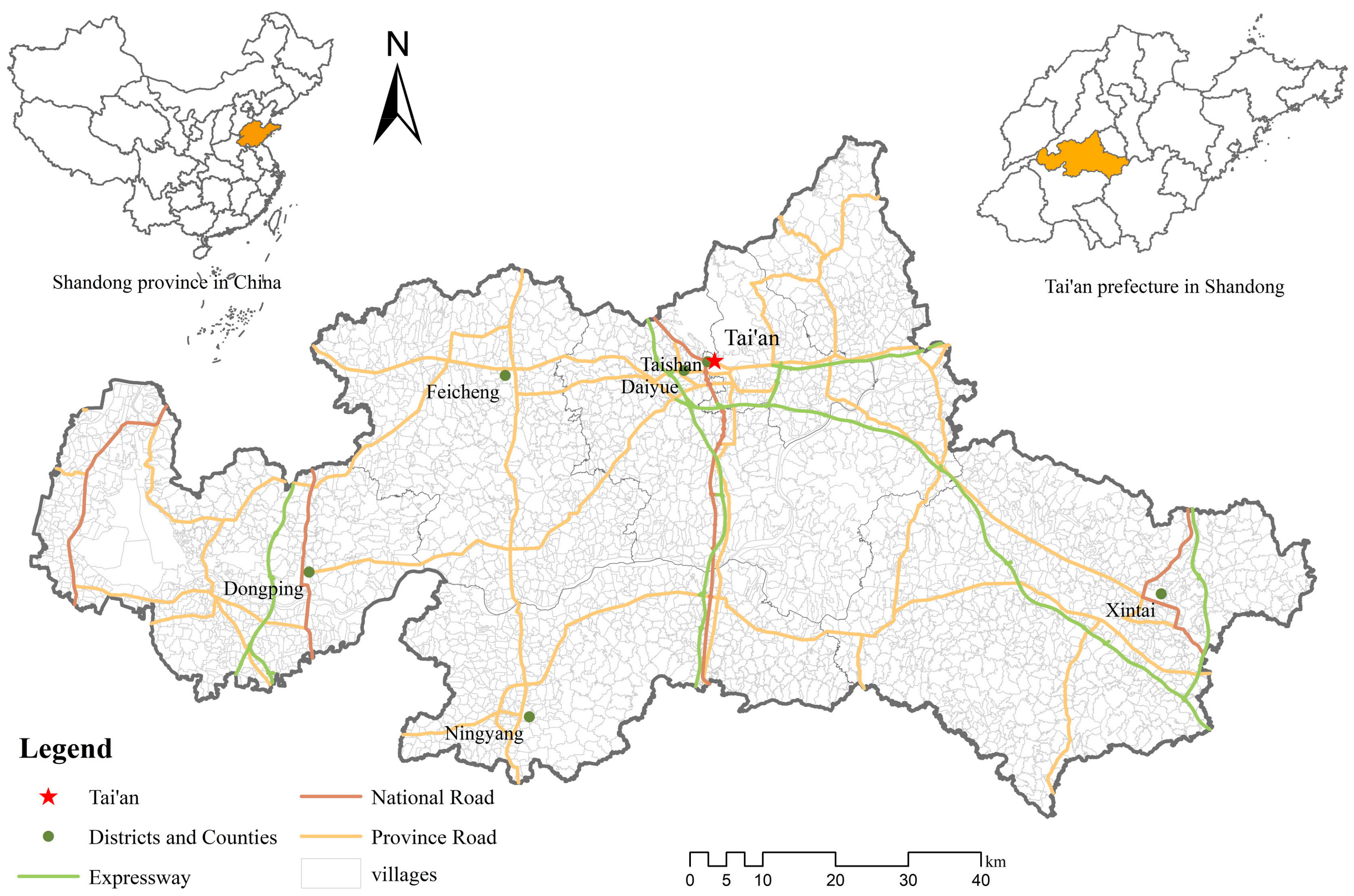
The prefecture-level city of Tai’an is located in the North China Plain, an important agricultural region in northern China (Figure 1). It is a prefecture-level administrative unit of central Shandong Province. Tai’an has a terrain sloping from northeast to southwest, with a varied topography including mountains, hills, plains, depressions, and lakes. Mountainous areas, concentrated in the north and east of the city, account for 18.3% of the city’s total land area. The altitude generally varies between 400 m and 800 m. Tai’an City has jurisdiction over six county-level administrative units, including two municipal districts, Taihsan and Daiyue, two county-level cities, Feicheng and Xintai, and two counties, Ningyang and Dongping. In 2015, the city’s total population was 5.60 million, 3.20 million urban and 2.40 million rural. The urbanization level was 57%.
Similar to other cities in China, Tai’an is experiencing rapid economic urbanization and expansion of construction land. The level of urbanization has exceeded 50% and the proportion of construction land is increasing annually. This study uses Tai’an as the research area to study the spatial distribution characteristics of rural construction land structure and their influencing factors in the rapid urbanization stage, with good typicality.
3.2. Data
3.2.1. Data Sources
The land use data of Tai’an City were derived from the data of the third land use survey of Tai’an City. According to the classification standard of the third land use survey regulation [57], rural construction land of Tai’an is divided into 18 types, including land for mining, roads, urban residential land, etc.
The administrative zoning map of the Tai’an village-level administrative unit used in this paper is derived from the village-level administrative boundary map in Tai’an’s third land use survey database. Since the research object of this paper is Tai’an’s villages, urban communities, state-owned agricultural farms, and forestry farms were excluded from selection. In addition, some villages were excluded from the study due to missing data, and 2585 village administrative units in the city were selected as research samples.
The social and economic statistics of the village-level administrative units in Tai’an used in this article are from the village-level social and economic statistics database of the Tai’an Statistics Bureau. These include the following primary statistical indicators: population, rural electricity consumption, land transfer area, and rural non-agricultural population. The road network data are derived from the Baidu map and the DEM (Digital Elevation Model) data from the Geospatial Data Cloud. The various data sources are shown in Table 1.
3.2.2. Data Processing
The distance between villages and the main road network and administrative centers at all levels was used in this study. ArcGIS software was used to extract the centroid and coordinates of villages for calculating various distance elements.
The distance from villages to the national road and provincial road was calculated using the NEAR tool in ArcGIS software, and the straight-line distance between each village’s center of mass point and the nearest national road and provincial road was obtained. The distance from villages to the highway toll station was calculated by the coordinates of each village’s center of mass and the high-speed toll station site.
The distance to the resident sites of governments at all levels was calculated through the center of mass point of each village and the coordinates of government resident sites.
The calculation formula of distance is as follows:
where d is the distance between the two places, and (x1, y1) and (x2, y2) are the coordinates of the two places, respectively.
The average elevation and average slope of each village were calculated using ArcGIS with 30 × 30 DEM data.
3.3. Methods
The main tasks of this study are as follows. First, we analyze the rural construction land structure’s spatial distribution characteristics at the village-level administrative unit in Tai’an City. Second, we discuss the factors influencing spatial distribution differences of the rural construction land structure in Tai’an.
3.3.1. Spatial Pattern Identification
For the analysis of rural construction land structure, the quantitative analysis method of landscape ecology is used to quantitatively describe and analyze the internal land use structure of rural residential areas in the study area, mainly through the diversity index and the concentration index.
- (1)
- Diversity index
This model was used to measure the diversity degree of land use structure, which has a certain guiding significance for its adjustment. When the area of land use structure is equal, the diversity index reaches maximum value in theory. The larger the diversity index, the greater the balance degree of land use. The calculation method was as follows:
where GM is the diversification index, Xi is the area of each type of construction land use, and n is the number of regional construction land types. The larger the GM value, the more diverse the construction land types and the more complex the land use structure.
- (2)
- Concentration index
This method was used to analyze the concentration of land use structure in rural residential areas; the larger the index, the more concentrated the land structure. This also means that the centralization degree of the data distribution is lower (more balanced). The calculation method was as follows:
where I is the regional land concentration index; A is the sum of the cumulative percentages of various types of regional land; M is the sum of the maximum cumulative percentages, assuming that the land is concentrated in a certain type; and R is the sum of the cumulative percentages of various types of regional land at the level of Tai’an.
- (3)
- Location quotient
The location quotient indicates the regional dominance of a certain type of construction land in the area, calculated using the ratio of the area of such construction land in the village to the total area of the village construction land and the ratio of the area of this type of construction land at the Tai’an City level to the total construction land area of Tai’an. The ratio of the two is expressed below with the following calculation method:
where N1 is the area of a certain type of construction land in a village, A1 is the total area of the village for construction land, N0 is the total area of this type of construction land for Tai’an, and A0 is the total area of construction land for Tai’an.
- (4)
- Local indicators of spatial association (LISA)
To better reflect the differentiation trend of rural construction land, local spatial autocorrelation analysis was adopted using the GIS spatial analysis method to analyze the above results and the LISA agglomeration map was drawn to describe its agglomeration and differentiation characteristics. The LISA agglomeration map can show whether the research object has agglomerated in space and where agglomeration occurs [58]. The following calculation was used:
where N and n represent the number of spatial units, Xi represents the observation value (i = 1, 2,…, n), represents the average value of Xi, and Wij represents the connection matrix between spatial units i and j.
In the LISA diagram, agglomeration is divided into four patterns, each of which identifies an area and its relationship with its neighboring areas. High-High is the area of high value aggregation, Low-Low is the area of low value aggregation, High-Low indicates that there is a low value cluster near the high value, while Low-High indicates the opposite.
3.3.2. Influencing Factors
- (1)
- Model selection
A multiple linear regression method was selected to analyze the factors influencing spatial differences in rural construction land structure. The formula is as follows:
where Y is the dependent variable, is the constant term, , , , and are independent variables, and … represent the regression coefficient of the independent variable, represents the random error, and multiple linear regression is estimated by the least squares method.
- (2)
- Independent variable selection
Based on the above analysis framework, four aspects were selected—terrain, location, economic factors, and social factors—to analyze the influence of each on the spatial distribution of rural construction land structure. Topographic conditions are the main natural factors of the rural construction land structure. Altitude and slope can affect the degree of development difficulty in the area. Regional natural conditions also include the farmland quality and ecological environment. We calculate the average grade of cultivated land and the average values of ecological importance and sensitivity for each village. The farmland grade represents the suitability of the land for cultivation; the higher the value, the more suitable the land for farming. The ecological importance refers to the importance of the land for the stability and service of local ecosystems; the higher the value, the more important the land for local ecosystem function. The ecological sensitivity refers to the sensitivity of the ecosystem to various external pressures and shocks such as climate changes and human activities, that is, the probability of ecological problems. The higher the value, the more prone the ecosystem is to ecological problems. For areas of high ecological importance and sensitivity, they are usually designated as ecological protection areas in spatial planning, where the development and utilization of construction land is severely restricted or completely prohibited.
Location factors include the distance from government resident sites, at all levels, and road accessibility. As government resident sites at all levels of Tai’an City are the political, economic, and cultural centers of the region, they play a decisive role in the development of the whole region under all levels of government. Generally, regional development extends to the periphery around the existing center, pushing existing cities to develop to the outskirts in a circular pattern and making the rural construction land structure of different locations appear different. Road accessibility affects the ease of information, labor force, and material exchange between the villages and the outside world, transforming rural functions and the structure of construction land use.
In terms of economic factors, the development of non-agricultural industries in rural areas directly reflects the functional transformation of traditional rural settlements and constantly changes the use structure of rural construction land.
In terms of social factors, population factors are among the most intuitive factors that affect land use mode. Population growth will inevitably lead to an increase in expenditures on eating, clothing, housing, transportation, etc., as well as increased demand for production and daily necessities. Rural land should meet production and living needs, and the consumption pattern and lifestyle of rural residents can directly affect the use mode and structure of rural construction land. The dependency ratio represents the working population’s dependency pressure. The higher the value, the greater the dependency pressure of the employed population in the village.
In terms of policy factors, we selected the share of basic farmland in total farmland of a village. The basic farmland protection policy is a basic state policy that delimits boundaries for high-quality cultivated land. The farmland within the boundary is termed as basic farmland that is strictly protected for national food security [55]. The strictest restriction on the development and non-agricultural utilization of basic farmland may affect the structure of rural construction land by limiting development for unnecessary purposes like industrial development.
Based on the above analysis of influencing factors, 12 such factors, as shown in Table 2, were selected to analyze spatial differentiation in the Tai’an rural construction land structure.
In order to weaken the effect of the heteroscedasticity of data in the model on the regression results, the natural logarithm of the data was considered.
4. Results
4.1. Spatial Patterns of Rural Construction Land Structure in Tai’an
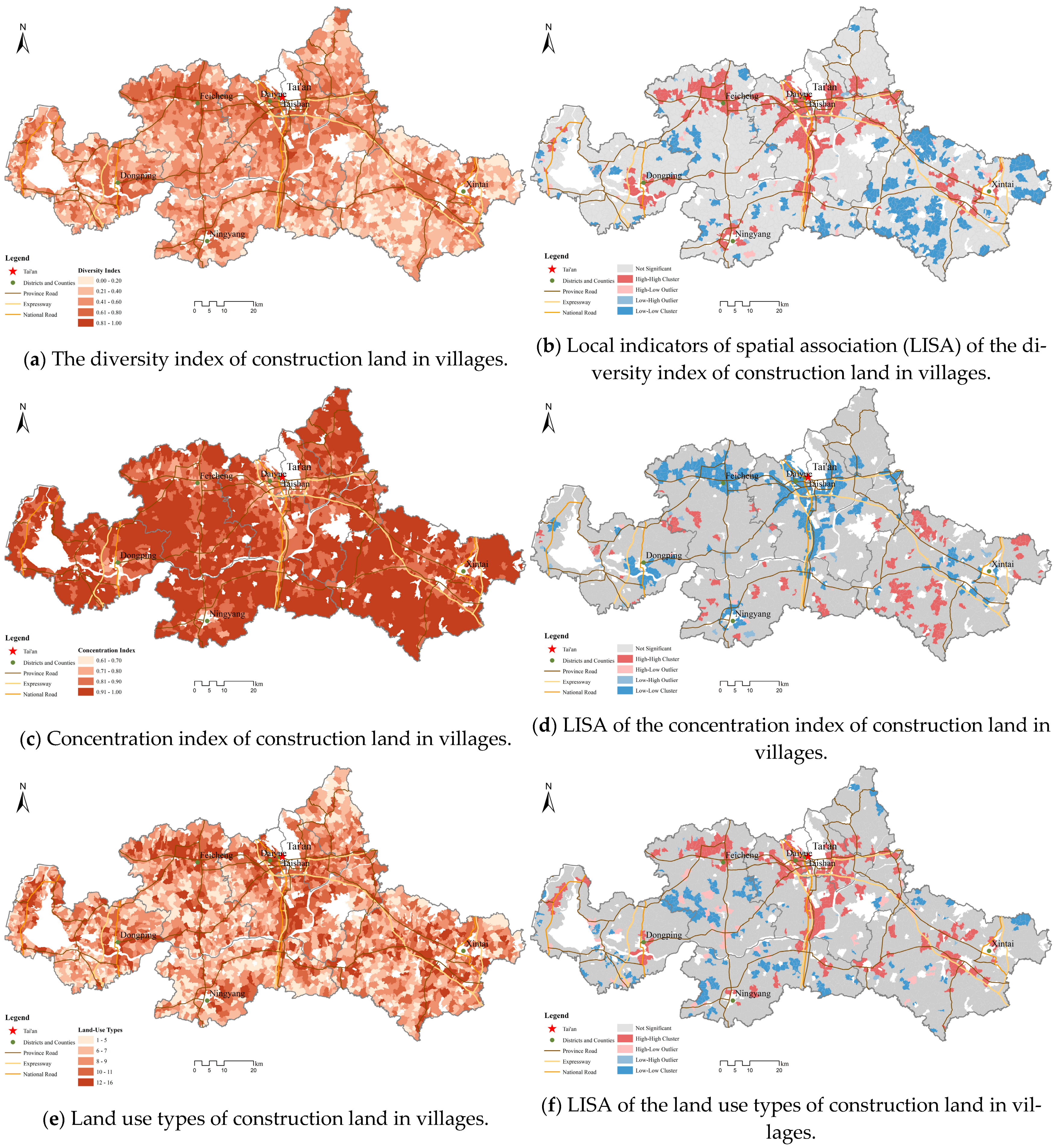
Rural construction land structure in Tai’an showed remarkable spatial differences. The diversity and concentration indexes of construction land in Tai’an’s villages were calculated, and the results are shown in Table 3. They show that the average land type of Tai’an’s villages is 7.52, the average diversity index is 0.44, and the average concentration index is 0.93. The overall degree of diversification is low, and construction land is mostly concentrated in some specific land types.
Among the six counties, Taishan (0.56) and Daiyue (0.51) had the highest diversity index of village construction land, and their concentration index was also the lowest. These two regions are the closest to the Tai’an City government and their urbanization process is the highest among all counties in Tai’an.
With changes in locations, the rural construction land structure is also changing across villages. As distance from governments at all levels and traffic access increased, the diversity index of rural settlements’ land structure showed a decreasing trend (Figure 2a), with high values clustered around Tai’an governments, all levels of district and county governments, and traffic arteries (Figure 2b). However, the concentration degree of land structure in rural residential areas shows the opposite tendency (Figure 2c,d), and the law of regional differentiation is obvious.
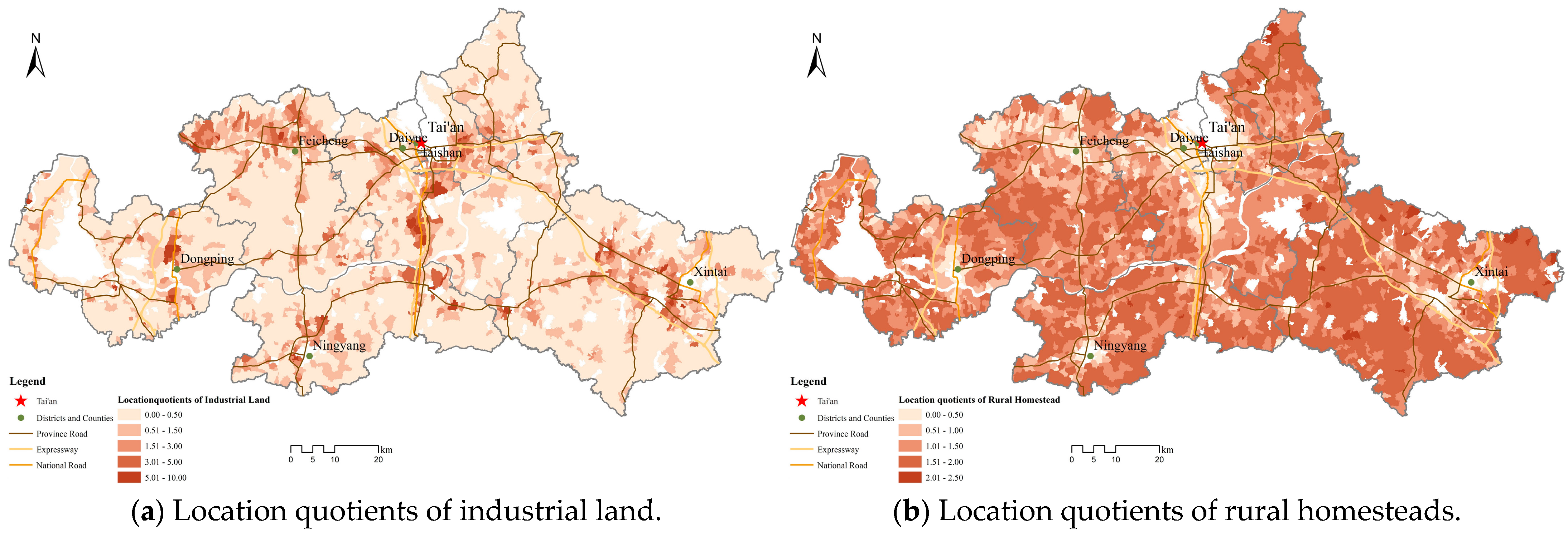
As two types of construction land occupying the largest proportions, rural industrial land and rural homestead, respectively, reflect the traditional residential function and industrial production function in the process of rural transformation. The distribution of the rural homestead location quotient and industrial location quotient show opposite tendencies (Figure 3a,b). In the spatial conversion process of the villages’ internal land structure, the interaction between homestead and industrial land has become the main feature. A typical village is a settlement area where people, whose main industrial activity is agriculture, live and work on land that is mainly homesteads and includes service facilities. The expansion of cities has led to continuous optimization and upgrading of rural industries in urban fringe areas with better geographical conditions, including the rapid development of rural diversified operations and the rural economy’s gradual departure from sole reliance on agricultural production. The structure has undergone significant changes, and the industrial structure has begun to diversify. Therefore, the better the location conditions, the higher the location quotients of rural industrial land (Figure 3a), that is, the higher the degree of dominance.
4.2. The Driving Forces for Spatial Differentiation of Rural Construction Land Structure in Tai’an
There are clear spatial differentiation rules in the rural construction land structure of each village in Tai’an. To further study the influencing factors of such spatial differentiation, multiple linear regression was performed on the selected independent variables, diversification index, concentration index, and land types. The regression results are shown in Table 4.
The regression results show that location, economic, social, and policy factors all significantly affect the spatial differentiation of rural construction land structure in villages of Tai’an.
Regarding rural construction land use structure, topography has a more obvious impact. The influence of altitude on the diversification index of rural construction land is negative (Beta = −0.136, p < 0.01). The influence of slope is also negative (Beta = −0.086, p < 0.01). This means that the higher the average altitude and the greater the slope of the village area, the worse the terrain conditions, and the simpler the construction land structure within the village area. This is mainly because the development and use of construction land is restricted by topographical conditions. The natural grade of cultivated land has no apparent influence on the diversity of rural construction land use (Beta = −0.000, p > 0.1). This may indicate the decoupling between local agricultural development and construction land use. The latter is influenced more by external forces than local agricultural sectors. The ecological environment has a significant impact on the diversity of construction land. The higher the ecological importance (Beta = −0.052, p < 0.01) and sensitivity (Beta = −0.056, p < 0.01), the lower the diversity of construction land. This is because the ecologically important and fragile areas will restrict the development and utilization of construction land.
Location factors have a significant impact on the structure of rural construction land. The regression results (Table 4) show that each location factor negatively impacts the diversity of construction land and its number of types, while the opposite impact is seen on the concentration of construction land.
Hence, the more distant the villages are from governments at all levels and the worse the traffic conditions—that is, the worse the location conditions—the lower the diversity degree, the higher the concentration degree, and the simpler the structure of the construction land of the villages.
Because urban industrial structures are constantly being transformed and upgraded, the rapid development and expansion of the economy is promoted, manifested in the replacement and upgrading of leading industries. Because the urban space of most cities in China is expanding in the “central–periphery” mode, the urbanization gradient is clear. Therefore, the degree of transformation differs depending on the level of urbanization. Areas with better location conditions in the periphery of the city are preferred for urban industry relocation. The better the location conditions, the stronger the radiation that accepts the growth pole and the higher the demand for industrial activities and the greater the intensity. Hence, the villages assume diverse functions as they must provide more land options for people’s economic activities, leading to the diversification of the structure of the land in use.
Regarding economic conditions, the rural per capita electricity consumption (Beta = 0.063, p < 0.01; Beta = 0.002, p > 0.1), the proportion of the rural non-agricultural population (Beta = 0.071, p < 0.01; Beta = 0.142, p < 0.01), and the area of land transfer (Beta = 0.095, p < 0.01; Beta = 0.134, p < 0.01) have positive effects on the diversification of rural construction land and its type. This further indicates that better social and economic development conditions lead to a greater number of villages with higher non-agricultural levels, which will have stronger resident demands for various services in their daily life. In addition to satisfying residents’ daily production and life needs, villages also derive various specialized rural services, such as leisure, catering, and tourism. The provision of services to these markets has resulted in the flourishing of commercial and service facilities. The richness of the villages’ internal functions led to the diversification of its construction land structure.
Regarding the conditions of social development, the regression results show that the higher the population density, the lower the diversification of construction land and the more unitary the land structure. This is because some very densely populated, community-style immigration resettlement villages have concentrated populations of rural residents. The construction land use form consists of rural homesteads, which mainly provide residential functions. The relevant infrastructure and business service facilities have yet to satisfy residents. The diversification rate of construction land use is extremely low.
Besides, policy factors also have significant effects on the diversification of rural construction land (Beta = −0.362, p < 0.01). The higher the proportion of basic farmland, the lower the diversification level of construction land, indicating the success of this farmland protection policy in restricting the development of farmland for construction uses.
5. Discussion and Conclusions
With the continuous advancement of urbanization, the rural function has also changed under the influence of urban expansion and its own endogenous development. The traditional functions of residence and agricultural production have diversified. As the driver of rural non-agricultural function development, diversified rural functions are directly reflected in the use structure of rural construction land. However, differences in the impact of urban expansion and rural economic and social development conditions also result in significant differences in the degree of functional transformation and the structure of construction land use in various villages. Taking the village-level units of Tai’an in Shandong Province as the research object, this study uses data from the third land survey to study the spatial differentiation of the rural construction land use structure in Tai’an. The regularity of the spatial differences in Tai’an’s rural construction land structure is summarized, and the relevant statistical model attempts to explain it.
The research results show that the construction land use structure in Tai’an has obvious spatial differentiation rules. Among the many factors, the villages’ location conditions, policy restriction, and their own economic and social development conditions are the most important factors affecting the spatial differentiation of the construction land use structure. The topographical conditions are not significant. With the extrapolation of rural location conditions and the deterioration of economic and social development, the diversification index of the construction land use structure and the types of land use in rural areas gradually decreased, the concentration increased, and land use structure became more unitary.
The rural regional system is multi-scale, multi-level, and multi-type. Rural revitalization is a systematic process of rural transformation and development, spatial reconstruction, and function upgrading in a certain region. Its core attributes follow the law of urban and rural development transformation in realizing overall rural system revitalization [59]. This requires analyzing and identifying the regional, legal, and phase characteristics of rural transformation and development. In response, we should adopt a differentiated perspective, divide and classify, advance more targeted development policies for different types of rural areas, and propose various rural construction land use adjustment modes.
With the extrapolation of location conditions, the spatial transfer of urban economic industries and services gradually weakens. The rural urbanization level in this region is relatively low, and the rural economy and social landscape have not completely disengaged from the traditional rural development model, which means the agricultural sector continues to be important in the socioeconomic development of many villages. Compared with the urban fringe areas, homestead location index land has gradually increased in area. This type of village should accelerate the construction of a regional living environment and cultivate the emergence of industrial growth poles.
In rural areas with poor location conditions, non-agricultural industries develop slowly. Their economic structure still maintains the typical characteristics of an agricultural economy, the rural landscape is typical too, and residential land has absolute advantage. Because of the lack of a radiation-driving effect in cities and towns, this type of village cannot enjoy the external effect of urban infrastructure, so the demand for service facilities and other facilities largely solves itself. These regions should, based on regional reality, choose their own industrial development path, and the intensive and economical use of construction land, to provide strong support for increasing local farmers’ incomes, agricultural efficiency, and healthy rural development. The development of rural infrastructure, science, education, culture, and health should continue to be promoted to further improve the lives of local residents.
As mentioned in the “National Rural Revitalization Strategic Plan: 2018–2022,” it is necessary to follow the development law and evolution trend of villages and promote rural revitalization according to the development status, location conditions, and resource endowment of different villages. These necessities have been proven by our empirical results that showed the heterogeneous paths of development and various patterns of spatial restructuring in different villages within a prefecture. The spillover of urban industries has stimulated the industrialization of villages in the suburbs where the land use structure is complex and diverse, indicating more opportunities for peasants therein to earn income from non-agricultural sectors. However, their quality of life is not necessarily higher than that of people living in remote areas because more factories scattered in the villages may also cause more severe pollution and a worse living environment. In contrast, residents in villages far from cities can hardly improve their quality of life without access to more and better job opportunities. In this sense, the urban–rural disparity in economic development may be reduced in the suburb; however, it remains in the remote area. Moreover, the disparity in living environment may be worsened in the future without proper measures being adopted to deal with new problems caused by rural industrialization. Therefore, we suggest that differentiated development policies should be adopted for different villages to help them pursue more suitable and effective paths of transformation and development and, by doing so, the development gap between urban and rural areas can be narrowed and peasants in different villages will be able to share the benefit of urbanization.
The transformation of rural functions and the structural evolution of construction land are long-term results, driven by both natural and human factors. This paper only analyzes the differentiation of construction land use structure and its influencing factors in the selected research area. In future studies, multi-period land use data should be used to analyze the development and changes of rural construction land use structure, and the law of spatial differentiation, on a certain time scale, and to explore the driving factors of such spatial differentiation. Such research will help us better identify the standard characteristics of rural development and transformation.
Author Contributions
Conceptualization, D.H. and T.L.; methodology, D.H., T.L. and Y.L.; software, Y.L.; validation, D.H. and Y.L.; formal analysis, Y.L.; resources, T.L. and D.H.; data curation, D.H. and Y.L.; writing—original draft preparation, D.H. and Y.L.; writing—review and editing, T.L. and D.H.; visualization, Y.L.; supervision, D.H. and T.L.; project administration, D.H.; funding acquisition, T.L. All authors have read and agreed to the published version of the manuscript.
Funding
This research was funded by the National Key Research and Development Program of China (2018YFD1100803).
Institutional Review Board Statement
Not applicable.
Informed Consent Statement
Not applicable.
Data Availability Statement
Data used in the paper were obtained from local land management authority and are not publicly available.
Conflicts of Interest
The authors declare no conflict of interest.
References
- Markey, S.; Halseth, G.; Manson, D. Challenging the inevitability of rural decline: Advancing the policy of place in Northern British Columbia. J. Rural Stud. 2008, 24, 409–421. [Google Scholar]
- Hedlund, M.; Lundholm, E. Restructuring of rural Sweden—Employment transition and out-migration of three cohorts born 1945–1980. J. Rural Stud. 2015, 42, 123–132. [Google Scholar]
- Liu, Y.; Li, Y. Revitalize the world’s countryside. Nature 2017, 548, 275–277. [Google Scholar] [PubMed]
- Wilson, G.A. The spatiality of multifunctional agriculture: A human geography perspective. Geoforum 2009, 40, 269–280. [Google Scholar]
- Allison, H.E.; Hobbs, R.J. Resilience, adaptive capacity, and the “lock-in trap” of the Western Australian agricultural region. Ecol. Soc. 2004, 9, 3. [Google Scholar]
- Gleeson, B. Critical commentary. Waking from the dream: An Australian perspective on urban resilience. Urban Stud. 2008, 45, 2653–2668. [Google Scholar]
- Elshof, H.; Haartsen, T.; van Wissen, L.J.G.; Mulder, C.H. The influence of village attractiveness on flows of movers in a declining rural region. J. Rural Stud. 2017, 56, 39–52. [Google Scholar]
- Zhu, F.; Zhang, F.; Li, C.; Zhu, T. Functional transition of the rural settlement: Analysis of land-use differentiation in a transect of Beijing, China. Habitat Int. 2014, 41, 262–271. [Google Scholar]
- Sikorski, D.; Latocha, A.; Szmytkie, R.; Kajdanek, K.; Miodonska, P.; Tomczak, P. Functional changes in peripheral mountainous areas in East Central Europe between 2004 and 2016 as an aspect of rural revival? Klodzko county case study. Appl. Geogr. 2020, 122, 102223. [Google Scholar]
- Paniagua, A. Farmers in remote rural areas: The worth of permanence in the place. Land Use Policy 2013, 35, 1–7. [Google Scholar]
- Knickel, K.; Redman, M.; Darnhofer, I.; Ashkenazy, A.; Chebach, T.C.; Sumane, S.; Tisenkopfs, T.; Zemeckis, R.; Atkociuniene, V.; Rivera, M.; et al. Between aspirations and reality: Making farming, food systems and rural areas more resilient, sustainable and equitable. J. Rural Stud. 2018, 59, 197–210. [Google Scholar] [CrossRef] [Green Version]
- Ruben, R.; Pender, J. Rural diversity and heterogeneity in less-favoured areas: The quest for policy targeting. Food Policy 2004, 29, 303–320. [Google Scholar] [CrossRef]
- Van Berkel, D.B.; Verburg, P.H. Sensitising rural policy: Assessing spatial variation in rural development options for Europe. Land Use Policy 2011, 28, 447–459. [Google Scholar] [CrossRef]
- Liu, Y.; Zhou, Y.; Li, Y. Rural regional system and rural revitalization strategy in China. Acta Geogr. Sin. 2019, 74, 2511–2528. [Google Scholar]
- Liu, Y.; Yang, Y.; Li, Y.; Li, J. Conversion from rural settlements and arable land under rapid urbanization in Beijing during 1985–2010. J. Rural Stud. 2017, 51, 141–150. [Google Scholar] [CrossRef]
- Hara, Y.; Takeuchi, K.; Okubo, S. Urbanization linked with past agricultural landuse patterns in the urban fringe of a deltaic Asian mega-city: A case study in Bangkok. Landsc. Urban Plan. 2005, 73, 16–28. [Google Scholar] [CrossRef]
- Ma, W.; Jiang, G.; Wang, D.; Li, W.; Guo, H.; Zheng, Q. Rural settlements transition (rst) in a suburban area of metropolis: Internal structure perspectives. Sci. Total Environ. 2018, 615, 672–680. [Google Scholar] [CrossRef]
- Wasilewski, A.; Krukowski, K. Land conversion for suburban housing: A study of urbanization around Warsaw and Olsztyn, Poland. Environ. Manag. 2004, 34, 291–303. [Google Scholar] [CrossRef] [Green Version]
- Hansen, A.J.; Brown, D.G. Land-use change in rural america: Rates, drivers, and consequences. Ecol. Appl. 2005, 15, 1849–1850. [Google Scholar] [CrossRef] [Green Version]
- Long, H.; Hellig, G.K.; Li, X.; Zhang, M. Socio-economic development and land-use change: Analysis of rural housing land transition in the transect of the Yangtse river, China. Land Use Policy 2007, 24, 141–153. [Google Scholar] [CrossRef]
- Huang, D.; Huang, J.; Liu, T. Delimiting urban growth boundaries using the clue-s model with village administrative boundaries. Land Use Policy 2019, 82, 422–435. [Google Scholar] [CrossRef]
- Po, L. Property rights reforms and changing grassroots governance in China’s urban-rural peripheries: The case of Changping district in Beijing. Urban Stud. 2011, 48, 509–528. [Google Scholar] [CrossRef]
- Po, L. Asymmetrical integration: Public finance deprivation in China’s urbanized villages. Environ. Plan. A 2012, 44, 2834–2851. [Google Scholar] [CrossRef]
- Li, Y.; Liu, Y.; Long, H.; Guo, Y. Village transformation development, resources and environment effects and their optimal regulation in the metropolitan suburbs: The case of beicun in shunyi district, beijing. Acta Geogr. Sin. 2013, 68, 825–838. [Google Scholar]
- Ustaoglu, E.; Williams, B. Determinants of urban expansion and agricultural land conversion in 25 eu countries. Environ. Manag. 2017, 60, 717–746. [Google Scholar] [CrossRef]
- Korten, D.C. Community organization and rural development: A learning process approach. Public Adm. Rev. 1980, 40, 480–511. [Google Scholar] [CrossRef] [Green Version]
- Siciliano, G. Urbanization strategies, rural development and land use changes in china: A multiple-level integrated assessment. Land Use Policy 2012, 29, 165–178. [Google Scholar] [CrossRef]
- Skinner, G.W. Marketing and social structure in rural China. J. Asian Stud. 1965, 24, 195–228. [Google Scholar] [CrossRef]
- Satsangi, M. Land tenure change and rural housing in Scotland. Scott. Geogr. J. 2007, 123, 33–47. [Google Scholar] [CrossRef]
- Linard, C.; Tatem, A.J.; Gilbert, M. Modelling spatial patterns of urban growth in Africa. Appl. Geogr. 2013, 44, 23–32. [Google Scholar] [CrossRef]
- Dumreicher, H. Chinese Villages and Their Sustainable Future: The European Union-China-Research Project “Success”. J. Environ. Manag. 2008, 87, 204–215. [Google Scholar] [CrossRef] [PubMed]
- Holmes, J.; Argent, N. Rural transitions in the nambucca valley: Socio-demographic change in a disadvantaged rural locale. J. Rural Stud. 2016, 48, 129–142. [Google Scholar] [CrossRef]
- Kiss, E. Rural restructuring in hungary in the period of socio-economic transition. Geojournal 2000, 51, 221–233. [Google Scholar] [CrossRef]
- Acreage, U.R. Rural Residential Land Use: Residential Land Use Is Growing Faster in Rural than in Urban Areas; USDA: Washington, DC, USA, 2002. [Google Scholar]
- Bittner, C.; Sofer, M. Land use changes in the rural–urban fringe: An Israeli case study. Land Use Policy 2013, 33, 11–19. [Google Scholar] [CrossRef]
- Champion, A.G. Urbanization and Counterurbanization. 1999. Available online: https://books.google.co.uk/books?hl=zh-TW&lr=&id=JGHicJThKuoC&oi=fnd&pg=PA347&dq=Urbanization+and+counterurbanization&ots=-8G81OC8Pk&sig=aVWgbznc8KwfsZWYlLzicy9J6VU#v=onepage&q&f=false (accessed on 30 November 2020).
- Liu, Y. Research on the urban-rural integration and rural revitalization in the new era in China. Acta Geogr. Sin. 2018, 73, 637–650. [Google Scholar]
- Long, H.; Liu, Y.; Li, X.; Chen, Y. Building new countryside in china: A geographical perspective. Land Use Policy 2010, 27, 457–470. [Google Scholar] [CrossRef]
- CPC. The CPC Central Committee and the State Council, National Rural Revitalization Strategic Plan (2018–2022). 2018. Available online: http://www.Gov.Cn/zhengce/2018-09/26/content_5325534.Htm (accessed on 30 November 2020).
- Long, H.; Li, Y.; Liu, Y.; Woods, M.; Zou, J. Accelerated restructuring in rural china fueled by ‘increasing vs. Decreasing balance’land-use policy for dealing with hollowed villages. Land Use Policy 2012, 29, 11–22. [Google Scholar] [CrossRef]
- Van Eupen, M.; Metzger, M.J.; Perez-Soba, M.; Verburg, P.N.; van Doorn, A.; Bunce, R.G.H. A rural typology for strategic European policies. Land Use Policy 2012, 29, 473–482. [Google Scholar] [CrossRef]
- Tian, Y.; Liu, Y.; Liu, X.; Kong, X.; Liu, G. Restructuring rural settlements based on subjective well-being (swb): A case study in Hubei province, central China. Land Use Policy 2017, 63, 255–265. [Google Scholar] [CrossRef]
- Zhou, G.; He, Y.; Tang, C.; Yu, T.; Xiao, G.; Zhong, T. Dynamic mechanism and present situation of rural settlement evolution in China. J. Geogr. Sci. 2013, 23, 513–524. [Google Scholar] [CrossRef]
- Gude, P.H.; Hansen, A.J.; Rasker, R.; Maxwell, B. Rates and drivers of rural residential development in the Greater Yellowstone. Landsc. Urban Plan. 2006, 77, 131–151. [Google Scholar] [CrossRef]
- Chisholm, M. Rural Settlement and Land Use; Hutchinson: London, UK, 1962. [Google Scholar]
- Li, Y.; Westlund, H.; Liu, Y. Why some rural areas decline while some others not: An overview of rural evolution in the world. J. Rural Stud. 2019, 68, 135–143. [Google Scholar] [CrossRef]
- Zhao, P. Sustainable urban expansion and transportation in a growing megacity: Consequences of urban sprawl for mobility on the urban fringe of Beijing. Habitat Int. 2010, 34, 236–243. [Google Scholar] [CrossRef]
- Huang, D.; Liu, Z.; Zhao, X. Monocentric or polycentric? The urban spatial structure of employment in Beijing. Sustainability 2015, 7, 11632–11656. [Google Scholar] [CrossRef] [Green Version]
- Huang, D.; Liu, Z.; Zhao, X.; Zhao, P. Emerging polycentric megacity in China: An examination of employment subcenters and their influence on population distribution in Beijing. Cities 2017, 69, 36–45. [Google Scholar] [CrossRef]
- Huang, D.; Jin, H.; Zhao, X.; Liu, S. Factors influencing the conversion of arable land to urban use and policy implications in Beijing, China. Sustainability 2015, 7, 180–194. [Google Scholar] [CrossRef] [Green Version]
- Huang, D.; Tan, X.; Liu, T.L.; Chu, E.; Kong, F. Effects of hierarchical city centers on the intensity and direction of urban land expansion: A case study of Beijing. Land 2020, 9, 312. [Google Scholar] [CrossRef]
- Nelson, P.B.; Oberg, A.; Nelson, L. Rural gentrification and linked migration in the United States. J. Rural Stud. 2010, 26, 343–352. [Google Scholar] [CrossRef]
- Yang, R.; Liu, Y.; Long, H.; Qiao, L. Spatio-temporal characteristics of rural settlements and land use in the Bohai Rim of China. J. Geogr. Sci. 2015, 25, 559–572. [Google Scholar] [CrossRef] [Green Version]
- Hao, P.; Geertman, S.; Hooimeijer, P.; Sliuzas, R. The land-use diversity in urban villages in Shenzhen. Environ. Plan. A 2012, 44, 2742–2764. [Google Scholar] [CrossRef]
- Zhong, T.; Huang, X.; Zhang, X.; Scott, S.; Wang, K. The effects of basic arable land protection planning in Fuyang county, Zhejiang province, China. Appl. Geogr. 2012, 35, 422–438. [Google Scholar] [CrossRef]
- Liu, J.; Liu, W.; Kuang, W.; Ning, J. Remote sensing-based analysis of the spatiotemporal characteristics of built-up area across China based on the plan for major function-oriented zones. Acta Geogr. Sin. 2016, 71, 355–369. [Google Scholar]
- MLR. Ministry of Land and Resources, National Standard Land Use Status Classification gb/t 21010-2017; China Standards Press: Beijing, China, 2017.
- Anselin, L. Local indicators of spatial association—Lisa. Geogr. Anal. 1995, 27, 93–115. [Google Scholar] [CrossRef]
- Liu, Y. Research on the geography of rural revitalization in the new era. Geogr. Res. 2019, 38, 461–466. [Google Scholar]
Figure 1.
Overview of the study area.

Figure 2.
Structural indices of rural construction land structure in Tai’an.

Figure 3.
Location quotients of different types of rural construction land.


Table 1.
Research variables and data sources.
| Factor | Variable | Unit | Meaning of Variable | Data Source |
|---|---|---|---|---|
| Terrain factors | Altitude | m | Average altitude of village | 30 × 30 dem data (geospatial data cloud http://www.gscloud.cn) |
| Slope | Average slope of village | 30 × 30 dem data (geospatial data cloud http://www.gscloud.cn) | ||
| Farmland grade | Average grade of cultivated land in village | Tai’an agricultural land grading data | ||
| Importance | Average ecological importance value of land in village | Tai’an ecological evaluation data | ||
| Sensitivity | Average ecological sensitivity value of land in village | Tai’an ecological evaluation data | ||
| Locational factors | DProad | km | Distance from village to the provincial road | National road vector data |
| DNroad | km | Distance from village to the national road | National road vector data | |
| DToll | km | Distance from village to expressway toll station | National road vector data, National POI (Point of Interest) data | |
| DCity | km | Distance from village to Tai’an municipal government | Map location coordinate query data (https://maplocation.sjfkai.com) | |
| DCounty | km | Distance from village to its county government | Map location coordinate query data (https://maplocation.sjfkai.com) | |
| DTown | km | Distance from village to its township government | Map location coordinate query data (https://maplocation.sjfkai.com) | |
| Economic factors | Non-agricultural | % | Proportion of rural non-agricultural population of each village | Tai’an Statistics Bureau |
| Electricity | kw·h | Per capita annual rural electricity consumption of village | Tai’an Statistics Bureau | |
| Land transfer | ha | Land transfer area of each village | Tai’an Statistics Bureau | |
| Social factor | Density | Person /km2 | Rural population density of each village | Tai’an Statistics Bureau |
| Dependency ratio | The ratio of the elderly and children to the employed population | Tai’an Statistics Bureau | ||
| Policy factor | Basic farmland | % | The proportion of basic farmland area in village | Tai’an basic farmland vector data |
Table 2.
Independent variables comprising the statistical table.
| Independent Variables | Average | Variance | Minimum | Maximum |
|---|---|---|---|---|
| Altitude (m) | 103.99 | 5100.05 | 24.06 | 623.67 |
| Slope (°) | 3.64 | 7.23 | 0.90 | 18.85 |
| Farmland grade | 7.16 | 1.16 | 5.00 | 10.00 |
| Importance | 3.21 | 0.12 | 0.00 | 4.00 |
| Sensitivity | 2.57 | 0.73 | 0.00 | 5.00 |
| DProad (km) | 2.93 | 5.69 | 0.00 | 13.67 |
| DNroad (km) | 13.68 | 72.33 | 0.01 | 35.76 |
| DToll (km) | 9.76 | 40.47 | 0.15 | 29.88 |
| DCity (km) | 43.72 | 520.41 | 2.26 | 97.56 |
| DCounty (km) | 18.82 | 93.27 | 0.51 | 43.32 |
| DTown (km) | 4.45 | 5.67 | 0.10 | 24.83 |
| Non-agricultural (%) | 0.65 | 0.03 | 0.00 | 1.00 |
| Electricity (kw·h) | 266.82 | 211,712.49 | 0.00 | 14,276.28 |
| Land transfer (ha) | 283.89 | 154,728.74 | 0.00 | 5080.00 |
| Density (person/km2) | 885.28 | 5,770,209.32 | 28.25 | 73,664.74 |
| Dependency ratio | 0.90 | 0.23 | 0.02 | 7.39 |
| Basic farmland (%) | 0.51 | 0.07 | 0.00 | 0.94 |
Table 3.
Description of rural construction land structure.
| Diversity Index | Concentration Index | Land Use Types | |
|---|---|---|---|
| Taishan | 0.56 | 0.89 | 9.45 |
| Daiyue | 0.51 | 0.91 | 8.12 |
| Xintai | 0.37 | 0.94 | 7.73 |
| Feicheng | 0.46 | 0.92 | 7.26 |
| Ningyang | 0.41 | 0.93 | 6.77 |
| Dongping | 0.42 | 0.93 | 7.13 |
| Tai’an Average | 0.44 | 0.93 | 7.52 |
Table 4.
Regression results.
| Dependent Variable | Diversity Index | Concentration Index | Land Use Types |
|---|---|---|---|
| Independent variable | Standardized coefficient (Beta) | Standardized coefficient (Beta) | Standardized coefficient (Beta) |
| Altitude | −0.136 *** (−3.364) | 0.034 (0.087) | 0.002 (0.057) |
| Slope | −0.086 *** (−3.444) | 0.117 *** (4.856) | −0.094 *** (−3.520) |
| Farmland grade | 0.000 (0.020) | −0.007 (−0.409) | 0.008 (0.431) |
| Importance | −0.052 *** (−2.946) | 0.048 *** (2.837) | −0.077 *** (−4.160) |
| Sensitivity | −0.056 ** (−2.436) | 0.065 *** (2.933) | −0.048 ** (−1.981) |
| DProad | −0.185 *** (−10.485) | 0.187 *** (11.024) | −0.146 *** (−7.818) |
| DNroad | 0.018 (0.862) | 0.011 (0.580) | −0.076 *** (−3.495) |
| DToll | −0.090 *** (−4.423) | 0.061 *** (3.143) | −0.050 ** (−2.351) |
| DCity | −0.164 *** (−5.079) | 0.108 *** (3.468) | −0.080 ** (−2.343) |
| DCounty | −0.066 *** (−3.379) | 0.108 *** (5.683) | −0.046 ** (−2.186) |
| DTown | −0.143 *** (−7.934) | 0.200 *** (11.507) | −0.178 *** (−9.309) |
| Non-agricultural | 0.056 *** (3.187) | −0.066 *** (−3.849) | 0.096 *** (5.151) |
| Electricity | 0.038 *** (2.194) | −0.035 ** (−2.069) | 0.018 (0.989) |
| Land transfer | 0.119 *** (6.752) | −0.115 *** (−6.771) | 0.153 *** (8.178) |
| Density | −0.269 *** (−12.641) | 0.214 *** (10.441) | −0.191 *** (−8.481) |
| Dependency ratio | 0.009 (0.527) | −0.016 (0.987) | 0.008 (0.464) |
| Basic farmland | −0.362 *** −17.034) | 0.363 *** (17.774) | −0.260 *** (−11.566) |
| N | 2585 | 2585 | 2585 |
| Adjusted R2 | 0.334 | 0.384 | 0.254 |
| F | 75.594 | 93.627 | 51.679 |
Note: **, and *** indicate significance at the 0.05, and 0.01 levels, respectively.
Publisher’s Note: MDPI stays neutral with regard to jurisdictional claims in published maps and institutional affiliations. |
© 2021 by the authors. Licensee MDPI, Basel, Switzerland. This article is an open access article distributed under the terms and conditions of the Creative Commons Attribution (CC BY) license (http://creativecommons.org/licenses/by/4.0/).
Share and Cite
MDPI and ACS Style
Huang, D.; Lang, Y.; Liu, T. The Evolving Structure of Rural Construction Land in Urbanizing China: Case Study of Tai’an Prefecture. Land 2021, 10, 65. https://0-doi-org.brum.beds.ac.uk/10.3390/land10010065
AMA Style
Huang D, Lang Y, Liu T. The Evolving Structure of Rural Construction Land in Urbanizing China: Case Study of Tai’an Prefecture. Land. 2021; 10(1):65. https://0-doi-org.brum.beds.ac.uk/10.3390/land10010065
Chicago/Turabian StyleHuang, Daquan, Yue Lang, and Tao Liu. 2021. "The Evolving Structure of Rural Construction Land in Urbanizing China: Case Study of Tai’an Prefecture" Land 10, no. 1: 65. https://0-doi-org.brum.beds.ac.uk/10.3390/land10010065
Note that from the first issue of 2016, this journal uses article numbers instead of page numbers. See further details here.