Morphogenesis of Emerging Settlements: Mapping Incremental Urbanism


1
School of Geography and Planning, Cardiff University, Cardiff CF10 3WA, UK
2
Faculty of Architecture, Near East University, Nicosia, TRNC 99138, Turkey
*
Author to whom correspondence should be addressed.
Land 2021, 10(1), 89; https://0-doi-org.brum.beds.ac.uk/10.3390/land10010089
Submission received: 16 November 2020
/
Revised: 8 January 2021
/
Accepted: 14 January 2021
/
Published: 19 January 2021
Abstract
:Informal urbanism has become a widespread form of urbanisation, particularly in the context of the global South. While there is an emerging body of knowledge focusing on the morphologies of informal settlements, the incremental transformations of emerging settlements have remained underexplored. Drawing on a case study of an emerging settlement in Nigeria, we map the emergence and incremental transformation of access networks and buildings. This is an exploratory study focusing on the morphogenesis of emerging settlements to explore how the incremental production of space works. We adopt urban mapping and typology as key methods. Following the analysis of emerging access networks, this paper identifies three primary types of change, namely add, alter, and remove, and further develops a typology of emerging junctions by specifying four types of T, Y, X, and Mixed shape junctions. The incremental transformations of buildings primarily incorporate practices of addition and removal, among others. We also identify three forms of relation between the emerging access networks and buildings: access network first, building first, and co-production. We argue that moving towards developing adaptive design interventions relies on a sophisticated understanding of the process of morphogenesis in emerging settlements.
1. Introduction
Informal urbanism has become a widespread form of urbanisation, particularly in the context of the global South. The urban future lies in cities of the global South and can most effectively be explored by closely looking at how they work [1] (p. 9). Forms of informality incorporate a range of tactical activities including what Bayat [2] calls ‘the quiet encroachment of the ordinary’ and what Tonkiss [3] calls ‘informality from above’ as tactical practices of the powerful. Our focus in this paper is on the former in the context of emerging ordinary built environments in the global South, where many people find shelter through informal processes [4] (p. 203). Urban informality is a multifaceted, complex and multidimensional concept, which hardly lends itself to accurate and concise definitions. It has been referred to as a way of life [1], a mode of space production and regulation [5], and more of a practice than a labour categorisation [6] with a capacity to enable activities and people to interact beyond regulatory frameworks [7]. Urban informality is also characterised by flexibility, decentralisation, and micro-scale entrepreneurial activities [8]. We begin with the view that informal urbanism is an open multiplicity working in relation to formality across different scales and contexts.
Accommodating about 881 million urban residents [9] (p. 48), informal settlements are among the primary forms of informal urbanism that have largely emerged outside of state control in terms of urban design, planning, architecture, construction, and codes. At stake is to seek a nuanced understanding of how these settlements work as the built environment professions can no longer ignore the task of designing, maintaining, or transforming the ordinary across scales [4]. Terminology can be challenging as informal settlements have also been referred to as unplanned, unauthorised, spontaneous, squatter, self-made, irregular, and slum, among others. While terms such as ‘informal’ and ‘squatter’ may interchangeably be used, squatter settlements refer to how freehold or state land can be occupied illegally [10]. The term ‘slum’ with enduring connotations of overcrowding and disease indicates a condition rather than a housing type [11]. The dynamics of both process and product of spontaneous settlements can also be explored using the frameworks developed to enable a sophisticated understanding of vernacular environments [12]. Exploring the critical role of users in housing design, management, and construction has been integral to the articulation of ‘housing as a verb’ by Turner [13]. Incremental change often comes with forms of improvisation and spontaneity [14]. We adopt emerging settlement broadly as a generative mode of planning, urban design, and architecture to analyse the emergence and incremental transformation of ordinary built environments.
While informal settlements may share some similarities across different contexts, there are different typologies and morphologies of informal settlement [15,16]. Most literature on informal urbanism engages with the dynamics of governance, political economy, or socio-economic processes, among others [2,17,18,19,20]. Yet, little is known about the micro-scale morphologies and morphogenesis of ordinary built environments. This study builds upon the emerging body of knowledge exploring the morphologies, typologies, and morphogenesis of informal settlements [21,22,23,24,25,26,27,28]. Analysing the growth of the road network over about two centuries in a study area in Milan, Strano et al. [29] showed quantitatively the two processes of ‘densification’ and ‘exploration’ that govern the evolution of the network. Iovene et al. [30] identified patterns of change in a settlement in Lima by analysing the urban form over about 70 years based on the notion that, while informal settlements often change at a fast rate, there are similarities between how informal settlements and pre-modern cities change. Porta et al. [31] found similar patterns in informal and historic street networks suggesting that informal settlements can be considered as contemporary examples illustrating the logic of self-organisation in historic cities. In a recent study by Geddes [32], a diachronic analysis was conducted to explore the mechanisms of growth in the case of Limassol. While the questions of visibility and image cannot be simply ignored [33], our focus in this paper is primarily on the ways in which the morphogenesis of emerging settlements work. Our aim here is by no means to focus on the aesthetics of the physical form.
Urban morphology plays a key role in urban design [34,35,36] and contributes to our understanding of the built environment by exploring human settlements, their forms, structures, and formation/transformation processes [37] (p. 9). Gauthier and Gilliland [38] mapped a range of contributions to the field of urban morphology by making distinctions between internalist/externalist approaches and cognitive/normative studies. Urban morphologists engage with the tangible outcomes of economic and social dynamics as they take place on the ground [39] (p. 3). It has been argued that poor understanding of urban morphology can lead to poor design interventions [34]. Berghauser Pont [40] argued for adopting an analytical approach with a focus on measuring urban form. Araldi and Fusco [41] put forward the Multiple Fabric Assessment method as a technique to analyse and classify urban fabrics. Exploring access networks has become a key area of urban design research as street patterns have the capacity to set a spatial framework for a range of other urban design aspects [42] (p. 251). The spatial layout of informal settlements and their locations in relation to the urban network can play a critical role in the extent to which they become consolidated [43]. Fekade [44] argued that the process of pre-urban informal development follows three stages: starting, boom, and saturation. While exploring the morphologies of emerging settlements relies on the analysis of the built environment at a given time, investigating the morphogenesis of settlement relies on the extent to which emerging spatial patterns, incremental transformations, and codes can be analysed by working backwards.
Exploring complexity, self-organisation, and urban evolution has also become a key theme in urban design and planning [45,46,47,48]. The seminal works of Jacobs [49] and Alexander [50] on how cities work are among the early key contributions here. While many urban thinkers including Patrick Geddes, Lewis Mumford, and Ebenezer Howard evoked the concept of the city as organism, the idea of cities as organisms potentially leads to confusion regarding the ways in which the built environment professions can engage with designing cities [51] (p. 25). Even though urban planning has often been associated with reducing complexity, the challenging task is to plan for generating and/or sustaining urban complexity [52]. Harnessing the productive capacities of urban complexity relies on a nuanced understanding of how self-organised environments such as emerging settlements work. Alexander and others have engaged with the challenge of understanding and developing generative processes [53,54,55]. Generative codes have also been explored further in the context of traditional settlements [56,57,58,59]. There is also emerging research using a shape grammar approach to explore self-organisation in informal settlements [60,61]. Much can be learnt from how incremental transformations work in emerging settlements as they have often been materialised through generative processes of adaptation and self-organisation. Our focus in this paper is on the process of morphogenesis to explore how the incremental production of space works by mapping the emerging access networks and buildings.
This study is among the early contributions to the evolving research theme exploring the morphogenesis of emerging settlements. Mapping the emergence and incremental transformations of access networks and buildings in this study enables us to address the following questions. What are the increments of change in terms of access networks and buildings? How do junctions emerge and change over time? What are the impacts of pre-existing conditions, such as pathways, on emergent access networks and buildings? How do incremental transformations work in emerging settlements? What are the relations between emerging access networks and buildings? It is important to note that this is not a study of the underlying social, cultural, political, and tenure conditions. This paper is structured into four interrelated sections, including methods, analysis and results, discussion, and conclusion. Following a concise description of research methods and case study, we outline the results of the analysis in terms of emerging access networks, junctions, and buildings, respectively. This paper concludes by discussing the key findings and further exploring the relations between the emerging access networks and buildings.
2. Methods
This is an exploratory study focusing on a single case to investigate how the process of self-organisation works, particularly in relation to emerging access networks and buildings. We adopt an inductive approach to identify emerging types and an abductive approach working backwards to analyse the process of morphogenesis. This is a morphogenesis study in nature, which explores the formation and transformation processes of the built environment [62] (p. 342). We use typology as a primary tool in urban analysis [63] (p. 6) and urban mapping as a way of producing spatial knowledge [64]. Typology and urban mapping have been previously used as key methods in emerging studies on forms of urban informality [15,21,24,25,26,33,65,66]. Type can be conceptualised at the intersection of social practices and the material realm [67] (p. 91). We used form types due to their capacity to describe and analyse physical configurations in the built environment [63] (p. 5). In this study, manual urban mapping has been adopted using Google Earth satellite imagery, Google Maps, and web searches as the primary data source to analyse the emerging access networks, junctions, and buildings in the selected case study. Several layers of mapping have been overlapped using the QGIS software to analyse the ways in which access networks and buildings have changed over time.
The emergence and consolidation of access networks and buildings have been chronologically mapped to trace the process of change with a focus on emergent morphologies and their incremental transformations. Mapping has been undertaken manually based on a database of multiple aerial photos (a total of seven aerial photos) of consistent intervals (every two years since 2007), which were downloaded from Google Earth and further superimposed. We kept a two-year interval between each layer of mapping to ensure consistency regarding the duration of each increment. The coordinate reference system WGS84/UTM Zone 32N (EPSG: 32632) was used for mapping. The selected case study has been mapped at the same scale (an area of about 1.9 Square Kilometres) from 2007 to 2019. Mapping of the access network shows how and where different laneways and roads have emerged and incrementally transformed over time. Several studies have also focused on the analysis of access network, including Strano et al. [29], Porta et al. [31], and Marshall [42], among others. Mapping of the buildings reveals the ways in which building footprints and coverage have changed during the same period. Incremental adaptations are integral to the fluidity of space and the ways in which improvisation works in emerging settlements [68]. While a range of design and construction increments, such as extend, attach, replace, divide, connect, and infill, can be identified [26], it is beyond the scope of this paper to analyse the micro-scale increments of construction as our analysis here is primarily at the settlement scale.
We have identified the following limitations, which are broadly related to case study selection and research methods. Google Earth archives often incorporate multiple satellite images from 2000 onwards. Many settlements that emerged and consolidated earlier than 2000 have been excluded as potential case studies with available data for chronological mapping. Small sites, inner-city settlements, dense areas, emerging settlements with linear morphology, and sites with a limited number or quality of satellite imagery have also been excluded. Mapping emerging access networks at the micro scale can become challenging depending on the extent to which narrow laneways and emergent pathways can be manually traced on satellite imagery. Google Street View has not been available at the time of data collection and analysis for the selected case study. Limited data availability on the local context has been a critical challenge and our web search has yielded very little knowledge in this regard. Exploring the underlying social, cultural, political, and tenure conditions has been a key limitation of the study and remains a task for future research.
Case Study Selection
Nigeria has faced rapid urbanisation associated with urban centres enabling rural-urban migration [69,70]. Challenges of land use management persist even though there are policies regarding land management and urban development in Nigeria [71] (p. 2). The challenge of planning in Nigeria was also discussed by Schatz [72] in relation to development and economic growth. While the master plan of Abuja, the planned capital of Nigeria, involved modern urban development, unplanned settlements have proliferated, forming most places outside the city boundaries including some pre-existing settlements as well [73] (p. 87). Adebanwi [74] critically reflected on the establishment of the centrally located Abuja Federal Capital Territory succeeding Lagos. Most informal workers and the urban poor live in peripheries and satellite settlements with long commutes to work [75] (p.17). The Federal Capital Territory has an area of about 8000 square kilometres with potentials for accessibility to other parts of the country [76] (p. 364). Land is subject to forms of speculation in Abuja although the land within the territory belongs to the government, which can put erected structures on informally purchased land at the risk of demolition [73] (pp. 84–85). As a fast growing city in Africa with the growth rate of 8.32% per year [77,78], Abuja has become a laboratory of emerging settlements that can be explored through different lenses.
The availability of satellite imagery with regular intervals provides an opportunity for exploring the process of morphogenesis starting with actual physical traces illustrating the step-by-step evolution of the access network and buildings. A range of emerging settlements was scouted for case study selection. Availability of multiple aerial images with reasonable quality has been one of the key case study selection criteria. Our attempt has been to minimise the impacts of some influential factors, such as proximity to the main road, proximity to large urban settlements, and steep topography. Limited physical proximity to the formal city at the settlement level has also been a key criterion for case study selection to possibly minimise the impacts of the adjacent formal morphology on the emerging settlement. We only considered places where a clear and consistent interval of historical satellite imagery was available via Google Earth dating back to the initial core of the settlement. It must be noted that investigating the socio-cultural and/or socio-economic contexts is beyond the scope of this paper and can be explored in future studies.
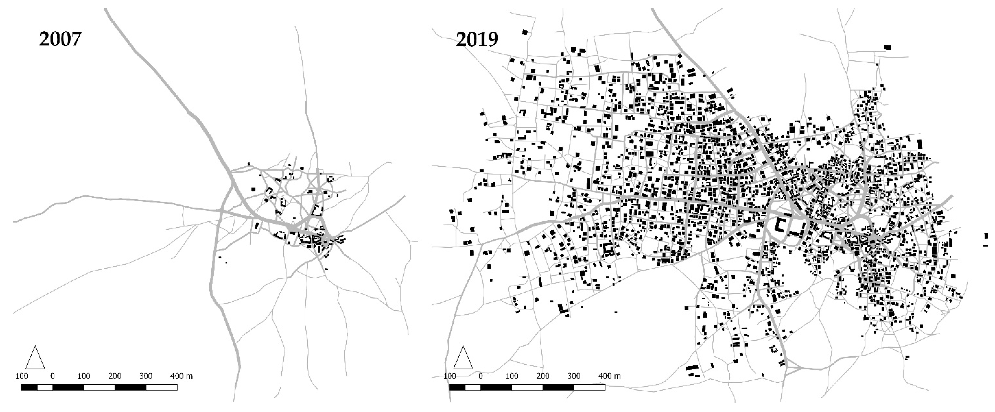
Among numerous explored settlements, Gbessa (8°55′49.57′′ N, 7°15′19.36′′ E) was selected as a case study to analyse the process of morphogenesis. The settlement is fairly flat and relatively far from the first joint with the main road (about 3.3 Kilometres) and other large urban settlements (about 6 Kilometres from Kuje). Figure 1 shows how the settlement has evolved rapidly from 2007 to 2019. It is critical to avoid conceptualising informal/formal as apposing dichotomies with some clear boundaries and binary distinctions since urbanism embodies a mix of informality and formality [79]. A more nuanced and complex approach is required to explore cities in Africa as informalisation/formalisation processes work together to produce urban forms and economies [80] (pp. 8–9). The informal/formal conceptual field developed by Dovey and Kamalipour [15] has enabled us to locate the selected case study based on the informality/formality of the access network and buildings. Our case study selection rationale is primarily morphological, and the conditions of tenure, living, or legality have not been among the case study selection criteria. The focus of this paper is on a single case study and there is no claim here for generalisability to other settlements in the context of the global South and beyond.
3. Analysis and Results
In this section, we present the case study analysis and point to a range of key findings. The analysis of emerging access network is followed by exploring different types of junctions in the process of morphogenesis to provide a better understanding of the emergence and incremental transformations of access network. The morphogenesis of buildings is then illustrated based on the analysis of the emerging building footprints to explore how the incremental production of buildings plays out in relation to the emerging access network. Certain spatial types in terms of emerging access network, junctions, and buildings are further identified as well.
3.1. Emerging Access Network
Figure 2 shows the analysis of the emerging access network and the related increments of change in the selected case study. We identified three types of spatial transformation, namely add, alter, and remove. The underlying agencies of the outlined types are reflected in the ways in which they are characterised as verbs. The identified types of incremental change have been mapped using red, green, and blue in Figure 2 to illustrate those parts of the access network that have been added, altered, or removed, respectively. The existing parts of the emerging access networks at a given time in each increment are also illustrated in Figure 2 using a black colour. The key attributes of the outlined increments of change are addressed in the following sections.
3.1.1. Add
Add is the most prevalent increment of change. Figure 2 shows how the existing access network became expanded over time through a number of additions in each increment from 2007 to 2019. The extent of the spatial evolution through expansion is not necessarily the same across different increments. Nevertheless, the overall spatial expansion of the access network is more towards the West than the East side of the emerging settlement due to some pre-existing features in the East, including a major road and waterway. While such features may enable a range of possibilities at the macro scale, they can constrain spatial expansion towards certain directions at the settlement scale. Pre-existing features at the settlement scale seem to play a crucial role in the ways in which new segments have been added to the existing access network in each increment. The emerging segments of the access network often follow the trajectory of some existing pathways and physical traces of linear movement on the ground. Certain patterns of informal movement leave physical traces, which can then be picked up to guide the evolution of the emerging access network in process of self-organisation. The impact of the pre-existing pathways on the emergence of access networks has been previously outlined by Ribeiro [27]. Pre-existing features have the capacity to guide the formation of an emerging access network. Yet, parts of the access network do not necessarily follow the existing traces of physical movement on the ground (Figure 2). A key characteristic of the addition type lies in its capacity to enhance spatial connectivity. The evolvement of the access network is geared to the provision of physical access to emerging buildings, and the emergence of new pathways in each increment often corresponds with the addition of new buildings. The relations between the emerging access network and buildings will be addressed later.
3.1.2. Alter
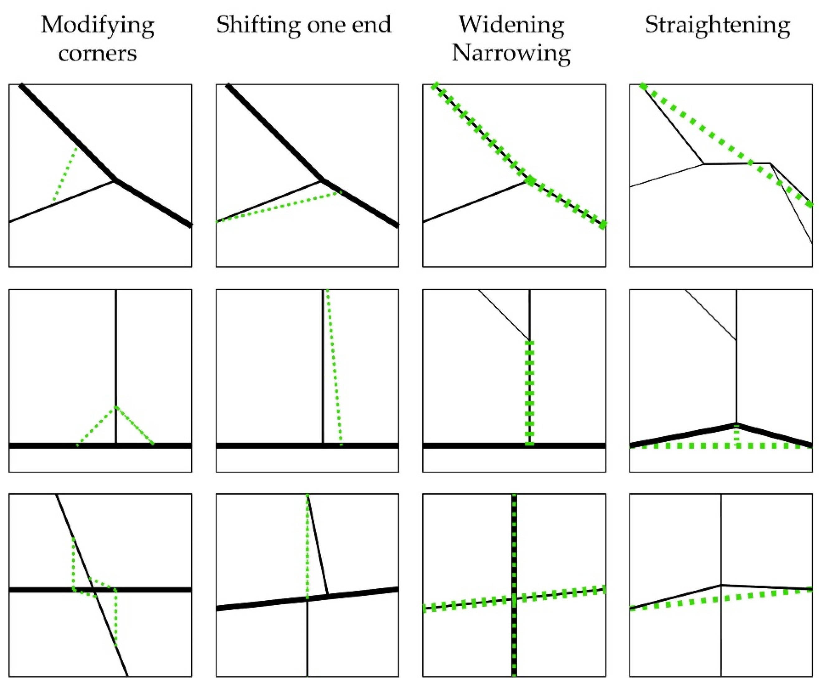
Alter is another common increment of change where elements of the access network adapt in response to the changing condition often to facilitate the emerging patterns of movement. Alteration incorporates a range of incremental adaptations. Following the analysis of the emerging access network in Figure 2, we identified different alteration types, namely modifying corners, shifting one end, widening/narrowing, and straightening. The identified forms of alteration are further illustrated in Figure 3 to show how each type plays out. As a form of alteration, corner modification takes place to smoothen the transition between intersecting segments of the access network often to enhance the flows of movement. Shifting one end is another form of alteration where changing one end of certain segments becomes a typical adaptation within the access network. This includes minor adjustments of the emergent parts of the access network in each increment. There are a few examples of this form of alteration (Figure 3). This type often takes place in relation to emerging flows of movement. Another key type of alteration is about forms of widening or narrowing some existing parts of the access network. Widening often takes place where the trajectory of movement remains relatively unchanged along certain parts of the access network, which often accommodate movement flows and stay put over time. It seems that choice and likelihood of use play a key role here as the network becomes expanded over time. Those parts of the access network, which have been used more frequently, are likely to become wider and maintain their trajectory over time. Widening is then a form of spatial stabilisation. There have also been only a few instances of narrowing over time. Straightening the trajectory of movement is one of the primary forms of alteration, which often takes place along some windy parts of the access network. Straightening the movement trajectory can become particularly important in the process of expanding the access network to enhance the continuity of movement flows.
3.1.3. Remove
Remove is a specific type of change where a part of the emerging access network gets removed over time. The significance of this type lies in its capacity to unravel how the process of self-organisation works in response to changing circumstances by revising its incremental development. Self-organisation is about incremental elimination as well as adaptation and addition. Certain parts of the access network have often been eliminated where there has been limited scope for adaptation to emerging conditions. Removal often takes place where certain parts of the existing access network overlap with emerging buildings. While formal interventions and regulatory frameworks prescribed in certain planning regimes may also lead to the elimination of self-organised parts of the access network, it is beyond our scope here to explore how formal planning can enforce or facilitate the process of elimination. In the later stages of network expansion, elimination occurs to remove those windy parts of the access network to pave the way for the formation of a regular grid or straighten the trajectory of movement.
3.2. Emerging Junctions
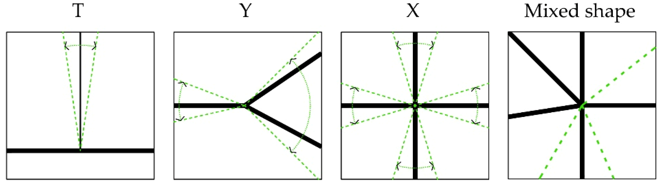
The emerging junctions are integral to the evolution of the access network. The incremental production of the access network gives rise to the emergence of multiple forms of junctions. Some of these junctions become consolidated over time. Following the analysis of the emerging access network, we identified four primary types of junctions, namely T, Y, X, and Mixed shape, by exploring how different movement trajectories intersect. This typology is primarily morphological with a focus on the spatial patterns of emerging junctions. The outlined types are illustrated in Figure 4, and their key characteristics are explored in the following sections.
3.2.1. T Shape
The T shape junctions emerge where a perpendicular pathway becomes connected to a continuous route. A 30-degree variation threshold was accounted for. Beyond that, it would be classified as a Y-shape junction. The distinction between the T and Y junctions is critical as they correspond to different morphogenesis processes. The T-shape junctions often appear in the rapidly developing parts of the access network and represent a geometrical order, whereas the Y-junctions seem to correspond to natural pedestrian flows in emerging access networks. The T-shape junctions can transform into the X-shape when a new intersecting pathway is introduced.
3.2.2. Y Shape
The Y-shape junctions emerge where a pathway branches out into two or a secondary pathway branches out of an ongoing main route. The Y-shape junctions are among the most prevailing types in the early stages of the access network formation. The natural pedestrian movement has a tendency to form paths that minimise the angular changes [81]. In this study, if two out of three pathways originating from a junction show a 120-degree angle or more, the junction is classified as a Y-shape. It seems that the Y-shape junctions frequently appear in the early stages of development as shortcuts to reduce the travel distance between different parts of the emerging access network.
3.2.3. X Shape
The X-shape junctions emerge where four pathways intersect or originate from a point. The most common instance of this type takes place when two continuous pathways cross each other. It also emerges where two pathways originate from a single point on a pathway, or just four independent pathways sharing a junction. The X-shape junctions often take place along the main pathways and are less frequent in inner parts of the network. The prime 90-degree angled X-shape junctions are not frequent in the initial form of the access network. The initial X-shape junctions tend to form angles that are in favour of a direction. The nature of this direction seems to be related to the hierarchy of movement in the network.
3.2.4. Mixed Shape
The mixed shape junctions are among the critical features of the initial access network incorporating multiple intersecting pathways. This type is rare compared to the others, but it often emerges in the central part of the emerging access network where many primary pathways tend to originate from a few central points. The mixed shape junctions are often stable and resilient, showing little to no change as the access network evolves. New mixed shape junctions may also occur where the X-shape junctions are joined with emerging pathways as the access network grows.
3.3. Emerging Buildings
Figure 5 shows the analysis of the emerging building footprints and their incremental transformations in the selected case study. We broadly identified two types of incremental change: add and remove. The identified types of spatial transformation have been mapped using red and blue in Figure 5 to illustrate the added or removed building footprints, respectively. The existing building footprints at a given time in each increment are also illustrated in Figure 5 using a black colour. Adding seems to be the most prevalent type of incremental change here. The extent and direction of spatial dispersal are not necessarily the same across different increments, even though the overall spatial expansion of the emerging building footprints is more towards the West than the East side of the settlement. The early development process is an exception as the spatial dispersal of the emerging building footprints can be observed in different directions (Figure 5). The relations between the emerging buildings and access network are further explored in the discussion section.
4. Discussion
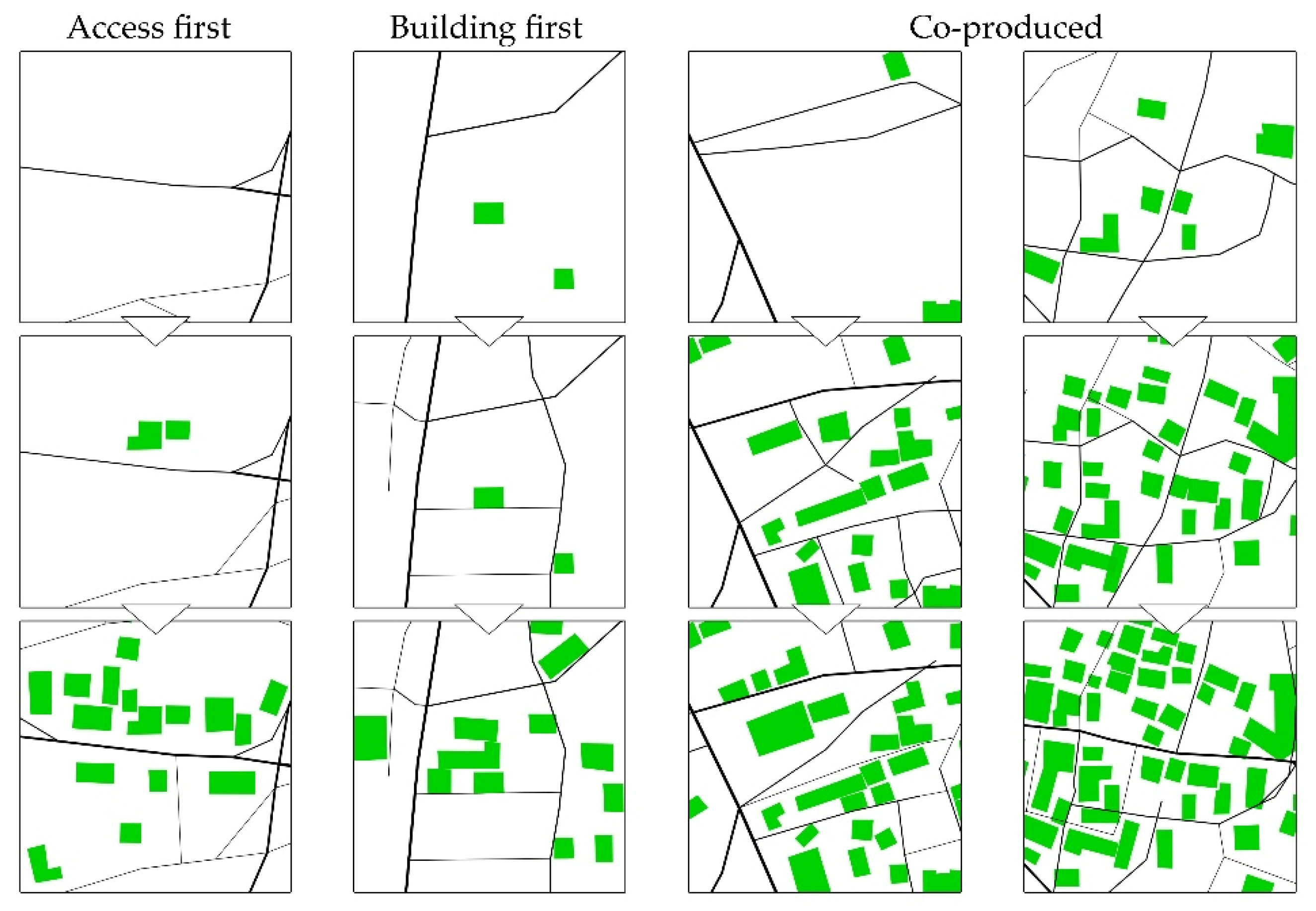
Following the analysis of the emerging access network (Figure 2) and building footprints (Figure 5), we identified three forms of relation: access first, building first, and co-production. Figure 6 illustrates the relations between the emerging access network and buildings. Access first is a primary form of incremental development. The initial stages of development show many footpaths that would later become integrated elements of the access network. These elements are often outgoing pathways formed over time, connecting to external resources, such as waterways, roads, nearby settlements, or farmlands. The building footprints emerge around these elements after being established as a part of the access network. Observations indicate that the most significant access network elements have emerged in relation to external destinations prior to building footprints. Building first is another key form of incremental development. In some cases, new structures encourage the formation of new access network elements. Generally, a new building cannot be constructed without an initial link to the existing access network. Nevertheless, these new buildings often become connected to the access network via more than their initial construction link. The new buildings, in this case, are often emerging destinations that influence the future development of the access network. Observations indicate that the new buildings often tend to reach the existing access network via the shortest available line. Hence, the emerging pathways in this process are more likely to form T-shape junctions. Co-production is a prevailing form of incremental development where access network and buildings co-evolve in emerging settlements. Most changes in the internal spatial structure of the settlement have come about through adaptive processes of co-production, enabling an ongoing interaction as the access network elements and building footprints evolve. The co-produced spatial structure is the result of many incremental steps linking the emerging access network and buildings. The analysis shows new buildings that remove an existing shortcut, and, simultaneously, influence the formation of new access network elements. The new buildings may also impact the previously mentioned altering processes of modifying corners, shifting one end, widening, or straightening.
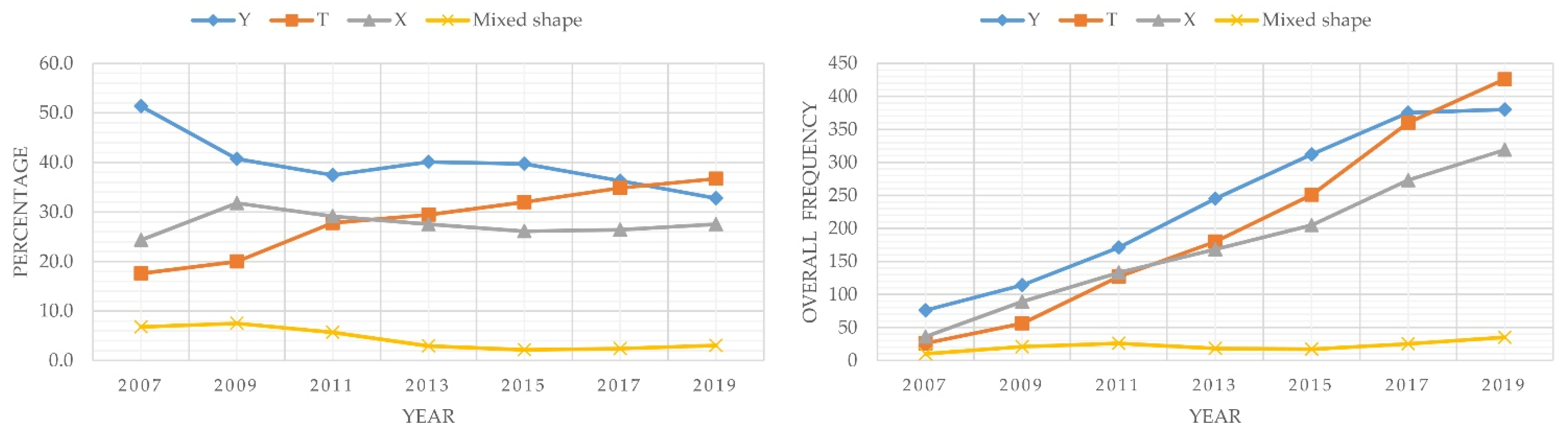
Earlier in this paper, we analysed the emergence of different junctions and categorised them into the T-shape, Y-shape, X-shape, and Mixed shape junctions based on their morphological types. In what follows, we discuss how certain types of junction emerge more frequently than others and how the percentages of different types also change over time. Figure 7 shows how the frequency and percentage of each junction type changed over time. The frequencies and percentages of different types have been analysed over time by counting the number of each junction type from 2007 to 2019. While the percentage of the X-shape junctions remains relatively unchanged, particularly after the early development process, the percentages of the T-shape and Y-shape junctions have considerably changed over time. We found two significant trends of change in the percentages of specific types, mainly the T-shape and Y-shape junctions. The emergence of the Y-shape and T-shape junctions has also been observed by Ribeiro [27] in Vila Paranoa where the formation of the Y-shape junctions was associated with diverging/converging patterns of movement in the initial stage of development. The emergence of the T-shape junctions was then associated with how the primary network of pathways met the secondary network of pathways in the subsequent development stage [27] (pp. 295–296). This is a significant finding in the context of emergent morphologies since the outlined types of junction incorporate different patterns of movement, as shown by Ribeiro [27] (pp. 296–297). Figure 7 shows how the percentage of the Y-shape junctions drops as that of the T-shape junctions rises from 2007 to 2019.
The previously mentioned patterns of change can be explored further in relation to the ways in which settlements emerge and become consolidated over time. The observed T-shape junctions seem to be related to certain geometrical properties of land ownership, planning, and infrastructure that come along with the rapid process of development. The adaptation processes that form the Y-shape junctions are often the result of preferred pathways that form gradually as emerging footpaths evolve to become more dominant routes. This seems to be flexible in the initial stages of development where there are limited spatial restrictions. Furthermore, the rapid development often comes with new infrastructure favouring planned junctions with clear geometries. Accordingly, as the access network evolves, the T-shape junctions become more abundant than the Y-types. While the Y-shape junctions are associated with natural movement, which often works with less angular change when moving towards the centre, the T-shape junctions seem to correspond to the neat separations of land. As the analysis indicates, many Y-shape junctions were transformed into other types. This is most visible in the eastern part of the settlement where many Y-shape junctions were formed in the initial stages of development, but the adaptation processes reshaped them into the T-shape junctions in the later stages of incremental transformation. This transformation process may also indicate the formalisation of the access network as well.
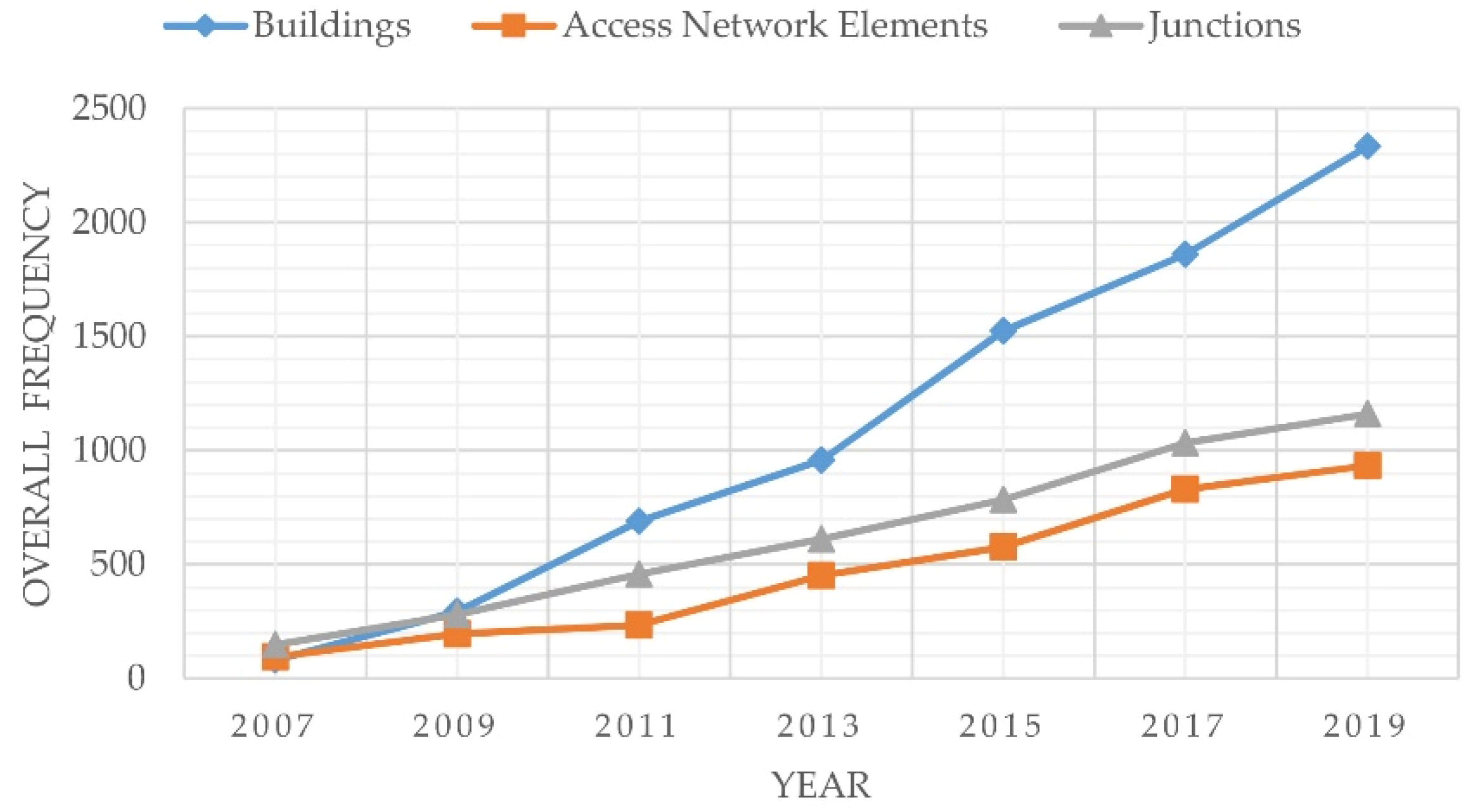
A key finding of our study is about the relations between the emergence and consolidation processes in the context of morphogenesis. Figure 8 shows how the incremental productions of the access network, junctions, and buildings have changed in relation to each other from 2007 to 2019. While the production of the access network and buildings was more or less close to each other in terms of frequency in the early stage of development, the production of buildings became considerably more than that of the access network in the later stages of incremental transformation. Making a distinction between the emergence and consolidation processes can play a key role here. Emergence can be considered as the initial process of development where territorial claims are being made. Consolidation is often a subsequent process of densification. The production of the access network seems to become significantly less than that of buildings in the consolidation process (Figure 8). Our finding here sheds light on the importance of the access network in the overall layout of emerging settlements. The scope for substantial change in access network seems to become limited once emerging settlements enter the consolidation phase. In other words, certain parts of the emergent access network become stratified as emerging settlements become consolidated. The infill process can then become the primary form of development. Building density can also become higher, particularly in terms of coverage. The production of buildings in the process of densification has been mostly horizontal and low-rise in the selected case study. The analysis shows how emerging settlements can reach a plateau in terms of the production of the access network and how the production of buildings can become noticeably more than that of the access network as settlements become consolidated. Further examination of the relations between emergence and consolidation remains a task for future research.
5. Conclusions
Cities are being made and remade by many, including the ordinary individuals. Our focus in this paper has been on exploring how the process of morphogenesis works in relation to the incremental production of access network and buildings. We analysed the emergence and incremental transformations of the access network and buildings in an emerging settlement to provide a better understanding of the dynamics of self-organisation and adaptation. Following the analysis of emerging access network, we identified three primary types of change: add, alter, and remove. A typology of emerging junctions has also been developed by specifying four morphological types, including the T, Y, X, and Mixed shape junctions. We also mapped the incremental production of buildings and observed that the incremental transformation of buildings primarily incorporated practices of addition and removal, among others. While we analysed the incremental production of the access network and buildings in turn, it is critical to note that they cannot be simply addressed in isolation from each other. Observations indicate that, while buildings can be influential in the process of altering the emerging access network, they seldom are the generators of the access network. They often seem to have impacts on the emerging access network by modifying individual elements.
Additions and alterations are often considered as typical increments of change in adaptive processes of self-organisation. Yet, removal is arguably the most intriguing increment of change, particularly in the context of emerging access networks. Alexander et al. [82] (p. 77) elaborated on how incremental changes can be considered as repairs in the urban fabric and how repairing is integral to incremental change with a realistic view that mistakes are, by and large, inevitable. Increments of change, including remove, can work as forms of repair adapting to a range of emerging needs and desires. The reflective capacities of adaptation play a key role here in correcting possible mistakes over time. Aligned with what Schön [83] called ‘reflection-in-action’ in relation to professional knowledge, we argue that such adaptive processes in the context of the built environment cannot be simply considered as random practices of trial and error since they often incorporate an underlying logic regarding how on-spot reflections on possible consequences of different increments can effectively inform forthcoming transformative actions.
Exploring the morphogenesis of emerging settlements is an evolving field of research and this study is among the early contributions. Following the analysis of emerging access network, junctions, and buildings, we explored the relations between the incremental production of the access network and buildings and identified several spatial types. It is important to note that the types we outlined in this paper are by no means archetypes, prototypes, or ideal types. While we have identified a range of typical processes and forms of adaptation in this study, there is no claim that the specified types are generalisable in a global context. Types emerge and unfold over time. Undertaking further empirical research using typology and chronological mapping across different case studies remains a key task for future research. It is also critical to develop relevant theoretical frameworks and examine the generalisability of the identified types. Adopting an essentialist approach to articulate the ways in which morphogenesis works in emerging settlements can be problematic, as we are not necessarily dealing with the production of some pre-existing images, rigid outcomes, or fixed entities in emerging settlements. What might be considered as a whole in this context is an emergent place in the process of becoming. Moving towards developing effective and adaptive design interventions relies on a sophisticated understanding of how the process of morphogenesis works in emerging settlements.
Author Contributions
Conceptualization, H.K. Methodology, H.K., and A.I. Validation, A.I. Formal analysis, A.I. Investigation, A.I., and H.K. Data curation, A.I. Writing—original draft preparation, H.K., and A.I. Writing—review and editing, H.K., and A.I. Visualization, A.I. Project administration, H.K., and A.I. All authors have read and agreed to the published version of the manuscript.
Funding
This research received no external funding.
Institutional Review Board Statement
Not applicable.
Informed Consent Statement
Not applicable.
Data Availability Statement
The data is primarily contained within the article. Any other relevant data is available from the authors upon request.
Conflicts of Interest
The authors declare no conflict of interest.
References
- AlSayyad, N. Urban Informality as a “New” Way of Life. In Urban Informality: Transnational Perspectives from the Middle East, Latin America, and South Asia; Roy, A., AlSayyad, N., Eds.; Lexington: Lanham, MD, USA, 2004; pp. 7–30. [Google Scholar]
- Bayat, A. Street Politics: Poor People’s Movements in Iran; Columbia University Press: New York, NY, USA, 1997. [Google Scholar]
- Tonkiss, F. Cities by Design: The Social Life of Urban Form; Polity: Cambridge, UK, 2013. [Google Scholar]
- Habraken, N.J. The Structure of the Ordinary: Form and Control in the Built Environment; Teicher, J., Ed.; MIT Press: Cambridge, MA, USA, 1998. [Google Scholar]
- Roy, A. Urban Informality: The Production and Regulation of Space. In International Encyclopedia of the Social & Behavioral Sciences; Wright, J.D., Ed.; Elsevier: Amsterdam, The Netherlands, 2015; Volume 24, pp. 818–822. [Google Scholar] [CrossRef]
- McFarlane, C. Rethinking Informality: Politics, Crisis, and the City. Plan. Theory Pract. 2012, 13, 89–108. [Google Scholar] [CrossRef]
- Simone, A. City Life from Jakarta to Dakar: Movements at the Crossroads; Routledge: New York, NY, USA, 2009. [Google Scholar]
- Bhatt, V.; Rybczynski, W. How the other half builds. In Time-Saver Standards in Urban Design; Watson, D., Plattus, A.J., Shibley, R.G., Eds.; McGraw-Hill: New York, NY, USA, 2003; pp. 1.3.1–1.3.12. [Google Scholar]
- UN-HABITAT. World Cities Report 2016: Urbanization and Development–Emerging Futures; UN-HABITAT: Nairobi, Kenya, 2016. [Google Scholar]
- Jones, P. Searching for a Little Bit of Utopia—Understanding the Growth of Squatter and Informal Settlements in Pacific Towns and Cities. Aust. Plan. 2012, 49, 327–338. [Google Scholar] [CrossRef]
- Huchzermeyer, M. Troubling Continuities: Use and utility of the term “slum”. In The Routledge Handbook on Cities of the Global South; Parnell, S., Oldfield, S., Eds.; Routledge: New York, NY, USA, 2014; pp. 86–97. [Google Scholar]
- Kellett, P.; Napier, M. Squatter Architecture? A Critical Examination of Vernacular Theory and Spontaneous Settlement with Reference to South America and South Africa. Tradit. Dwell. Settl. Rev. 1995, 6, 7–24. [Google Scholar]
- Turner, J.F.C. Housing as a verb. In Freedom to Build: Dweller Control of the Housing Process; Turner, J.F.C., Fichter, R., Eds.; Macmillan: New York, NY, USA, 1972; pp. 148–175. [Google Scholar]
- Hamdi, N. Small Change: About the Art of Practice and the Limits of Planning in Cities; Earthscan: London, UK, 2004. [Google Scholar]
- Dovey, K.; Kamalipour, H. Informal/Formal Morphologies. In Mapping Urbanities: Morphologies, Flows, Possibilities; Dovey, K., Pafka, E., Ristic, M., Eds.; Routledge: New York, NY, USA, 2018; pp. 223–248. [Google Scholar] [CrossRef]
- Dovey, K.; King, R. Forms of Informality: Morphology and Visibility of Informal Settlements. Built Environ. 2011, 37, 11–29. [Google Scholar] [CrossRef] [Green Version]
- Davis, M. Planet of Slums; Verso: New York, NY, USA, 2006. [Google Scholar]
- McFarlane, C.; Waibel, M. (Eds.) Urban Informalities: Reflections on the Formal and Informal; Ashgate: Farnham, UK, 2012. [Google Scholar]
- Neuwirth, R. Shadow Cities: A Billion Squatters, a New Urban World; Routledge: New York, NY, USA, 2005. [Google Scholar]
- Roy, A.; AlSayyad, N. (Eds.) Urban Informality: Transnational Perspectives from the Middle East, Latin America, and South Asia; Lexington: Lanham, MD, USA, 2004. [Google Scholar]
- Dovey, K.; van Oostrum, M.; Chatterjee, I.; Shafique, T. Towards a Morphogenesis of Informal Settlements. Habitat Int. 2020, 104, 102240. [Google Scholar] [CrossRef]
- Jones, P. The Shaping of Form and Structure in Informal Settlements: A Case Study of Order and Rules in Lebak Siliwangi, Bandung, Indonesia. J. Reg. City Plan. 2019, 30, 43–61. [Google Scholar] [CrossRef]
- Jones, P. Distance and Proximity Matters: Understanding Housing Transformation through Micro-Morphology in Informal Settlements. Int. J. Hous. Policy 2020. [Google Scholar] [CrossRef]
- Kamalipour, H. Forms of Informality and Adaptations in Informal Settlements. Int. J. Archit. Res. 2016, 10, 60–75. [Google Scholar] [CrossRef]
- Kamalipour, H.; Dovey, K. Incremental Urbanisms. In Mapping Urbanities: Morphologies, Flows, Possibilities; Dovey, K., Pafka, E., Ristic, M., Eds.; Routledge: New York, NY, USA, 2018; pp. 249–267. [Google Scholar] [CrossRef]
- Kamalipour, H.; Dovey, K. Incremental Production of Urban Space: A Typology of Informal Design. Habitat Int. 2020, 98, 102133. [Google Scholar] [CrossRef]
- Ribeiro, G. An Ecological Approach to the Study of Urban Spaces: The Case of a Shantytown in Brasilia. J. Archit. Plan. Res. 1997, 14, 289–300. [Google Scholar]
- Mottelson, J.; Venerandi, A. A Fine-Grain Multi-Indicator Analysis of the Urban Form of Five Informal Settlements in East Africa. Urban Sci. 2020, 4, 31. [Google Scholar] [CrossRef]
- Strano, E.; Nicosia, V.; Latora, V.; Porta, S.; Barthélemy, M. Elementary Processes Governing the Evolution of Road Networks. Sci. Rep. 2012, 2, 296. [Google Scholar] [CrossRef] [PubMed] [Green Version]
- Iovene, M.; De Córdova, G.F.; Romice, O.; Porta, S. Towards Informal Planning: Mapping the Evolution of Spontaneous Settlements in Time. In Proceedings of the 24th ISUF 2017-City and Territory in the Globalization Age; Universitat Politècnica de València, Valencia, Spain, 27–29 September 2017. [Google Scholar]
- Porta, S.; Romice, O.; Maxwell, J.A.; Russell, P.; Baird, D. Alterations in Scale: Patterns of Change in Main Street Networks across Time and Space. Urban Stud. 2014, 51, 3383–3400. [Google Scholar] [CrossRef] [Green Version]
- Geddes, I. Understanding the Mechanisms and Impact of Growth on the Urban Form and Functioning of Cities: An Application to the Case of Limassol. Athens J. Mediterr. Stud. 2020, 6, 39–66. [Google Scholar] [CrossRef]
- Kamalipour, H.; Dovey, K. Mapping the Visibility of Informal Settlements. Habitat Int. 2019, 85, 63–75. [Google Scholar] [CrossRef]
- Marshall, S.; Çalişkan, O. A Joint Framework for Urban Morphology and Design. Built Environ. 2011, 37, 409–426. [Google Scholar] [CrossRef]
- Scheer, B.C. The Master Plan Is Dead: Long Live Urban Morphology. Urban Morphol. 2013, 17, 48–50. [Google Scholar]
- Talen, E. Urban Design as Urban Morphology. Urban Morphol. 2014, 18, 69–70. [Google Scholar]
- Kropf, K. The Handbook of Urban Morphology; John Wiley & Sons: Chichester, UK, 2017. [Google Scholar]
- Gauthier, P.; Gilliland, J. Mapping Urban Morphology: A Classification Scheme for Interpreting Contributions to the Study of Urban Form. Urban Morphol. 2006, 10, 41–50. [Google Scholar]
- Moudon, A.V. Urban Morphology as an Emerging Interdisciplinary Field. Urban Morphol. 1997, 1, 3–10. [Google Scholar]
- Berghauser Pont, M. An Analytical Approach to Urban Form. In Teaching Urban Morphology; Oliveira, V., Ed.; Springer International Publishing: Cham, Switzerland, 2018; pp. 101–119. [Google Scholar] [CrossRef]
- Araldi, A.; Fusco, G. From the Street to the Metropolitan Region: Pedestrian Perspective in Urban Fabric Analysis. Environ. Plan. B Urban Anal. City Sci. 2019, 46, 1243–1263. [Google Scholar] [CrossRef]
- Marshall, S. Streets and Patterns; Spon Press: Oxon, UK, 2005. [Google Scholar]
- Hillier, B.; Greene, M.; Desyllas, J. Self-Generated Neighbourhoods: The Role of Urban Form in the Consolidation of Informal Settlements. Urban Des. Int. 2000, 5, 61–96. [Google Scholar] [CrossRef]
- Fekade, W. Deficits of Formal Urban Land Management and Informal Responses under Rapid Urban Growth, an International Perspective. Habitat Int. 2000, 24, 127–150. [Google Scholar] [CrossRef]
- Batty, M. Cities and Complexity: Understanding Cities with Cellular Automata, Agent-Based Models, and Fractals; MIT Press: Cambridge, MA, USA, 2005. [Google Scholar]
- Marshall, S. Cities, Design & Evolution; Routledge: New York, NY, USA, 2009. [Google Scholar]
- Portugali, J. Self-Organization and the City; Springer: New York, NY, USA, 2000. [Google Scholar]
- Portugali, J.; Meyer, H.; Stolk, E.; Tan, E. (Eds.) Complexity Theories of Cities Have Come of Age: An Overview with Implications to Urban Planning and Design; Springer: New York, NY, USA, 2012. [Google Scholar]
- Jacobs, J. The Death and Life of Great American Cities; Random House: New York, NY, USA, 1961. [Google Scholar]
- Alexander, C. A City Is Not a Tree. Archit. Forum 1965, 122, 58–61. [Google Scholar]
- Batty, M.; Marshall, S. The Origins of Complexity Theory in Cities and Planning. In Complexity Theories of Cities Have Come of Age: An Overview with Implications to Urban Planning and Design; Portugali, J., Meyer, H., Stolk, E., Tan, E., Eds.; Springer: New York, NY, USA, 2012; pp. 21–45. [Google Scholar] [CrossRef]
- Marshall, S. Planning, Design and the Complexity of Cities. In Complexity Theories of Cities Have Come of Age: An Overview with Implications to Urban Planning and Design; Portugali, J., Meyer, H., Stolk, E., Tan, E., Eds.; Springer: New York, NY, USA, 2012; pp. 191–205. [Google Scholar] [CrossRef]
- Alexander, C.; Ishikawa, S.; Silverstein, M.; Jacobson, M.; Fiksdahl-King, I.; Angel, S. A Pattern Language: Towns, Buildings, Construction; Oxford University Press: New York, NY, USA, 1977. [Google Scholar]
- Alexander, C.; Neis, H.; Anninou, A.; King, I. A New Theory of Urban Design; Oxford University Press: New York, NY, USA, 1987. [Google Scholar]
- Alexander, C.; Schmidt, R.; Hanson, B.; Alexander, M.M.; Mehaffy, M. Generative codes: The path to building welcoming, beautiful, sustainable neighborhoods. In New Urbanism and Beyond: Designing Cities for the Future; Haas, T., Ed.; Rizzoli: New York, NY, UK, 2008; pp. 14–29. [Google Scholar]
- Davis, H. The Culture of Building; Oxford University Press: New York, NY, USA, 2006. [Google Scholar]
- Hakim, B.S. Generative Processes for Revitalizing Historic Towns or Heritage Districts. Urban Design Int. 2007, 12, 87–99. [Google Scholar] [CrossRef]
- Hakim, B.S. The Generative Nature of Islamic Rules for the Built Environment. Int. J. Archit. Res. 2010, 4, 208–212. [Google Scholar]
- Hakim, B.S. Mediterranean Urbanism: Historic Urban/Building Rules and Processes; Springer: New York, NY, USA, 2014. [Google Scholar]
- Dias, M.A. Informal Settlements: A Shape Grammar Approach. J. Civ. Eng. Archit. 2014, 8, 1389–1395. [Google Scholar] [CrossRef]
- Verniz, D.; Duarte, J.P. Santa Marta Urban Grammar: Unraveling the Spontaneous Occupation of Brazilian Informal Settlements. Environ. Plan. B Urban Anal. City Sci. 2020. [Google Scholar] [CrossRef]
- Moudon, A.V. A Catholic Approach to Organizing What Urban Designers Should Know. J. Plan. Lit. 1992, 6, 331–349. [Google Scholar] [CrossRef]
- Scheer, B.C. The Evolution of Urban Form: Typology for Planners and Architects; Routledge: New York, NY, USA, 2017. [Google Scholar]
- Dovey, K.; Pafka, E.; Ristic, M. (Eds.) Mapping Urbanities: Morphologies, Flows, Possibilities; Routledge: New York, NY, USA, 2018. [Google Scholar]
- Kamalipour, H. Mapping Urban Interfaces: A Typology of Public/Private Interfaces in Informal Settlements. Spaces Flows Int. J. Urban Extra Urban Stud. 2017, 8, 1–12. [Google Scholar] [CrossRef]
- Kamalipour, H.; Peimani, N. Negotiating Space and Visibility: Forms of Informality in Public Space. Sustainability 2019, 11, 4807. [Google Scholar] [CrossRef] [Green Version]
- Gauthier, P. Conceptualizing the Social Construction of Urban and Architectural Form through the Typological Process. Urban Morphol. 2005, 9, 83–93. [Google Scholar]
- Kamalipour, H. Improvising Places: The Fluidity of Space in Informal Settlements. Sustainability 2020, 12, 2293. [Google Scholar] [CrossRef] [Green Version]
- Obi-Ani, N.A.; Isiani, M.C. Urbanization in Nigeria: The Onitsha Experience. Cities 2020, 104, 102744. [Google Scholar] [CrossRef]
- Oyeleye, O.I. Challenges of Urbanization and Urban Growth in Nigeria. Am. J. Sustain. Cities Soc. 2013, 2, 79–95. [Google Scholar]
- Aribigbola, A. Imroving Urban Land Use Planning and Management in Nigeria: The Case of Akure. Cercetǎri Pract. Si Teoretice în Managementul Urban 2008, 3, 1–14. [Google Scholar]
- Schatz, S.P. The Influence of Planning on Development: The Nigerian Experience. Soc. Res. 1960, 27, 451–468. [Google Scholar]
- Abubakar, I.R. Abuja City Profile. Cities 2014, 41, 81–91. [Google Scholar] [CrossRef]
- Adebanwi, W. Abuja. In Capital Cities in Africa: Power and Powerlessness; Bekker, S., Theron, G., Eds.; HSRC Press: Cape Town, South Africa, 2012; pp. 83–102. [Google Scholar]
- Adama, O. Abuja Is Not for the Poor: Street Vending and the Politics of Public Space. Geoforum 2020, 109, 14–23. [Google Scholar] [CrossRef]
- Nwafor, J.C. The Relocation of Nigeria’s Federal Capital: A Device for Greater Territorial Integration and National Unity. GeoJournal 1980, 4, 359–366. [Google Scholar] [CrossRef]
- UN-HABITAT. The State of African Cities: A Framework for Addressing Urban Challenges in Africa; UN-HABITAT: Nairobi, Kenya, 2008. [Google Scholar]
- Myers, G. African Cities: Alternative Visions of Urban Theory and Practice; Zed Books Ltd.: New York, NY, USA, 2011. [Google Scholar]
- Kamalipour, H.; Peimani, N. Informal Urbanism in the State of Uncertainty: Forms of Informality and Urban Health Emergencies. Urban Des. Int. 2020. [Google Scholar] [CrossRef]
- Mbembe, A.; Nuttall, S. Introduction: Afropolis. In Johannesburg: The Elusive Metropolis; Nuttall, S., Mbembe, A., Eds.; Duke University Press: Durham, NC, USA, 2008; pp. 1–36. [Google Scholar] [CrossRef]
- Dalton, R.C. The Secret Is to Follow Your Nose: Route Path Selection and Angularity. Environ. Behav. 2003, 35, 107–131. [Google Scholar] [CrossRef] [Green Version]
- Alexander, C.; Silverstein, M.; Angel, S.; Ishikawa, S.; Abrams, D. The Oregon Experiment; Oxford University Press: New York, NY, USA, 1975. [Google Scholar]
- Schön, D.A. The Crisis of Professional Knowledge and the Pursuit of an Epistemology of Practice. J. Interprof. Care 1992, 6, 49–63. [Google Scholar] [CrossRef]
Figure 1.
Selected case study 2007–2019.

Figure 2.
Mapping the emerging access network.

Figure 3.
Instances of the alteration types.

Figure 4.
Types of the emerging junctions.

Figure 5.
Mapping the emerging building footprints.

Figure 6.
The relations between the emerging access network and buildings.

Figure 7.
The percentage and frequency of different junction types 2007–2019.

Figure 8.
The frequencies of the access network elements, junctions, and building footprints 2007–2019.
Figure 8.
The frequencies of the access network elements, junctions, and building footprints 2007–2019.

Publisher’s Note: MDPI stays neutral with regard to jurisdictional claims in published maps and institutional affiliations. |
© 2021 by the authors. Licensee MDPI, Basel, Switzerland. This article is an open access article distributed under the terms and conditions of the Creative Commons Attribution (CC BY) license (http://creativecommons.org/licenses/by/4.0/).
Share and Cite
MDPI and ACS Style
Kamalipour, H.; Iranmanesh, A. Morphogenesis of Emerging Settlements: Mapping Incremental Urbanism. Land 2021, 10, 89. https://0-doi-org.brum.beds.ac.uk/10.3390/land10010089
AMA Style
Kamalipour H, Iranmanesh A. Morphogenesis of Emerging Settlements: Mapping Incremental Urbanism. Land. 2021; 10(1):89. https://0-doi-org.brum.beds.ac.uk/10.3390/land10010089
Chicago/Turabian StyleKamalipour, Hesam, and Aminreza Iranmanesh. 2021. "Morphogenesis of Emerging Settlements: Mapping Incremental Urbanism" Land 10, no. 1: 89. https://0-doi-org.brum.beds.ac.uk/10.3390/land10010089
Note that from the first issue of 2016, this journal uses article numbers instead of page numbers. See further details here.