
Mining, Urban Growth, and Agrarian Changes in the Atacama Desert: The Case of the Calama Oasis in Northern Chile

 , , ,
, , , 
Abstract
:1. Introduction
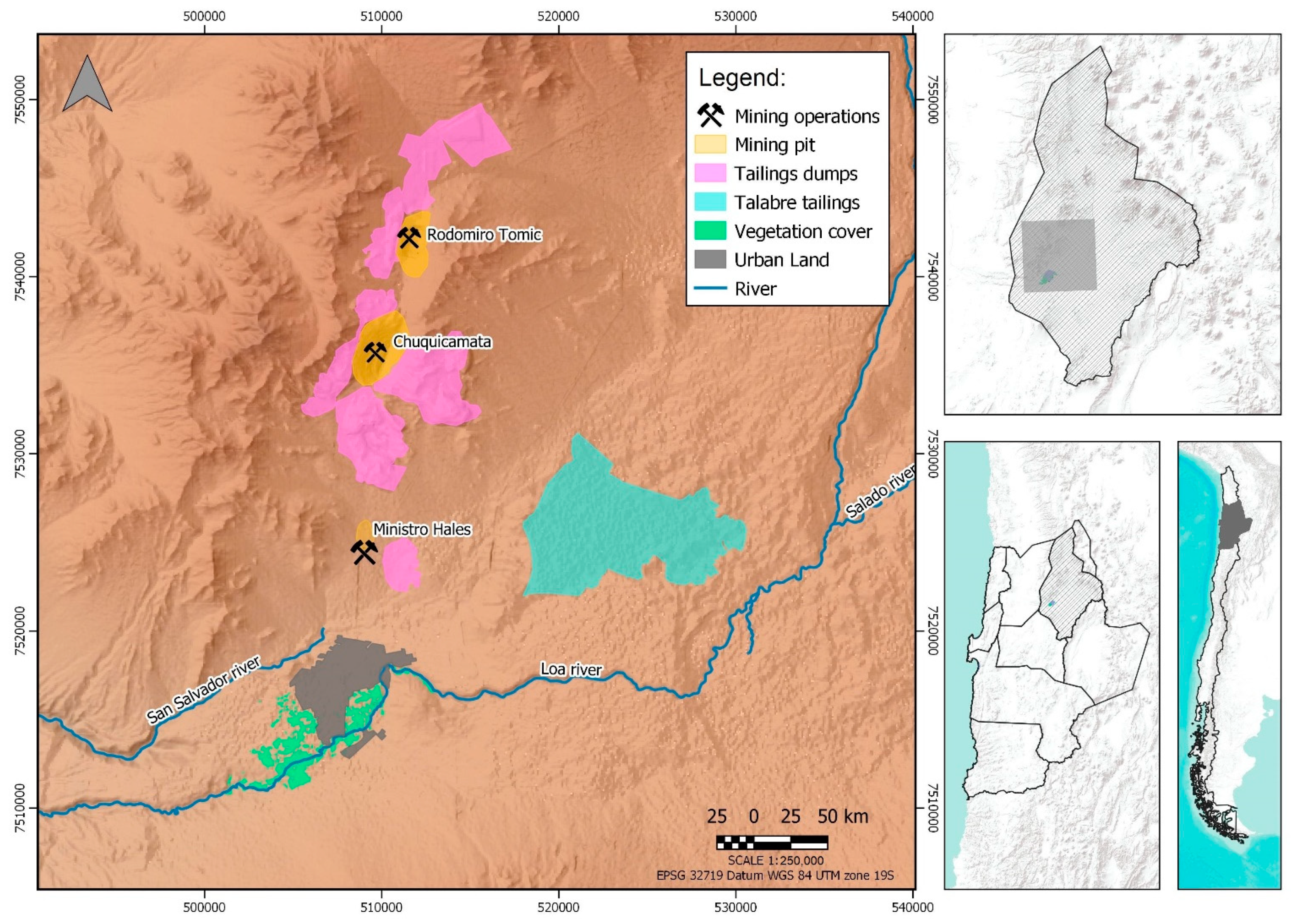
2. Case Study
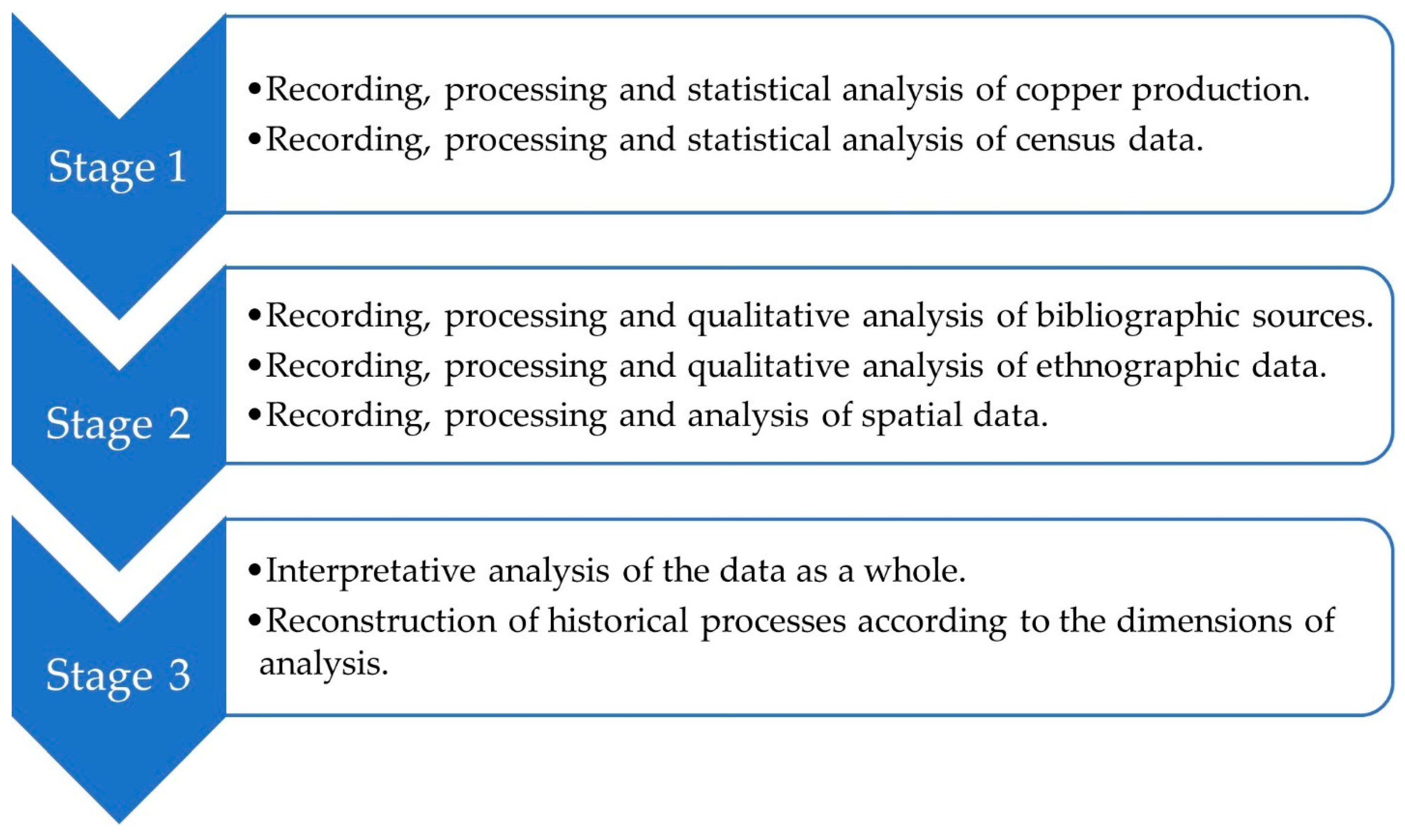
3. Methods
4. The Expansion of Large-Scale Copper Mining, Urban Growth, and Access to Water Resources
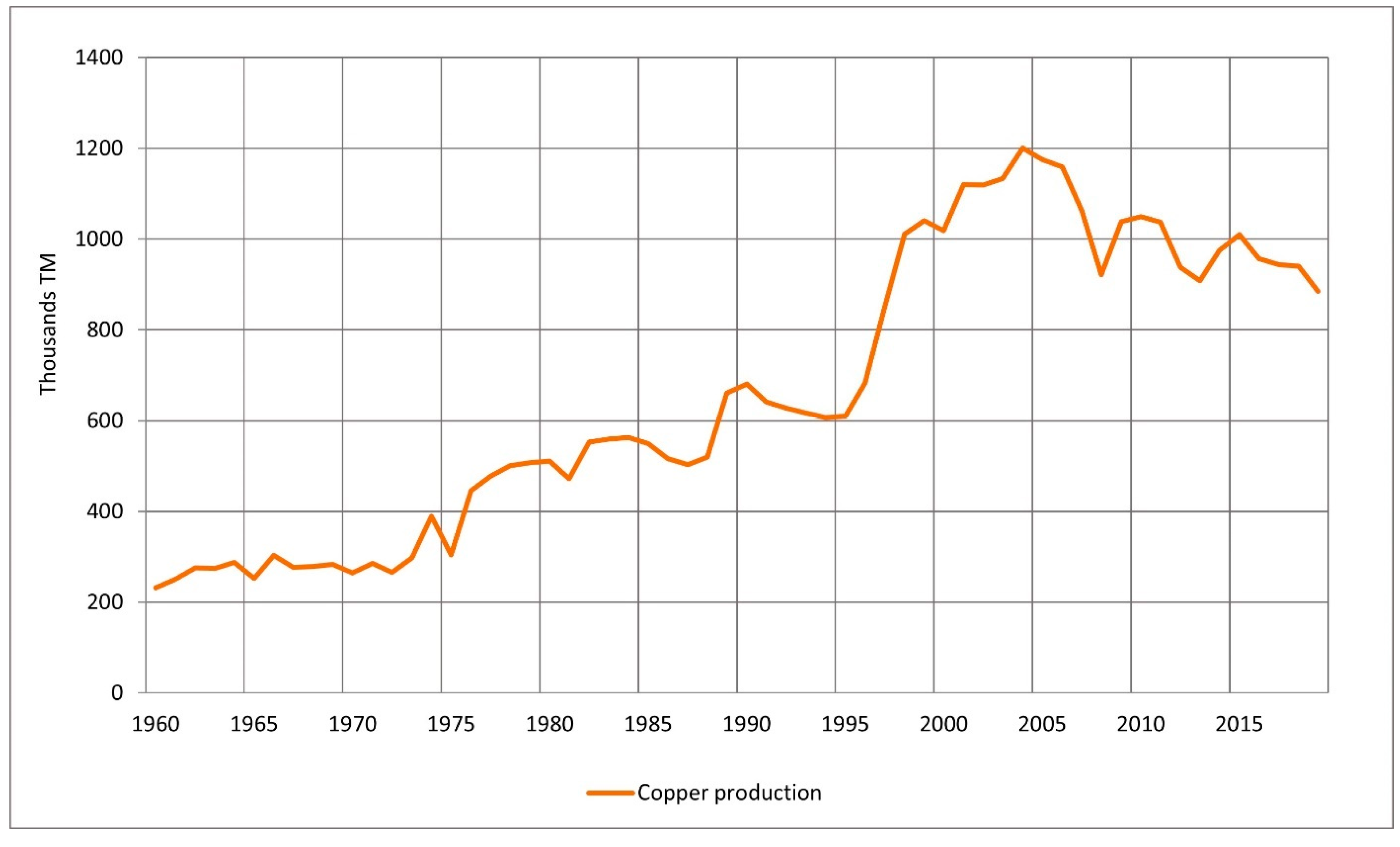
4.1. Development of Large-Scale Copper Mining
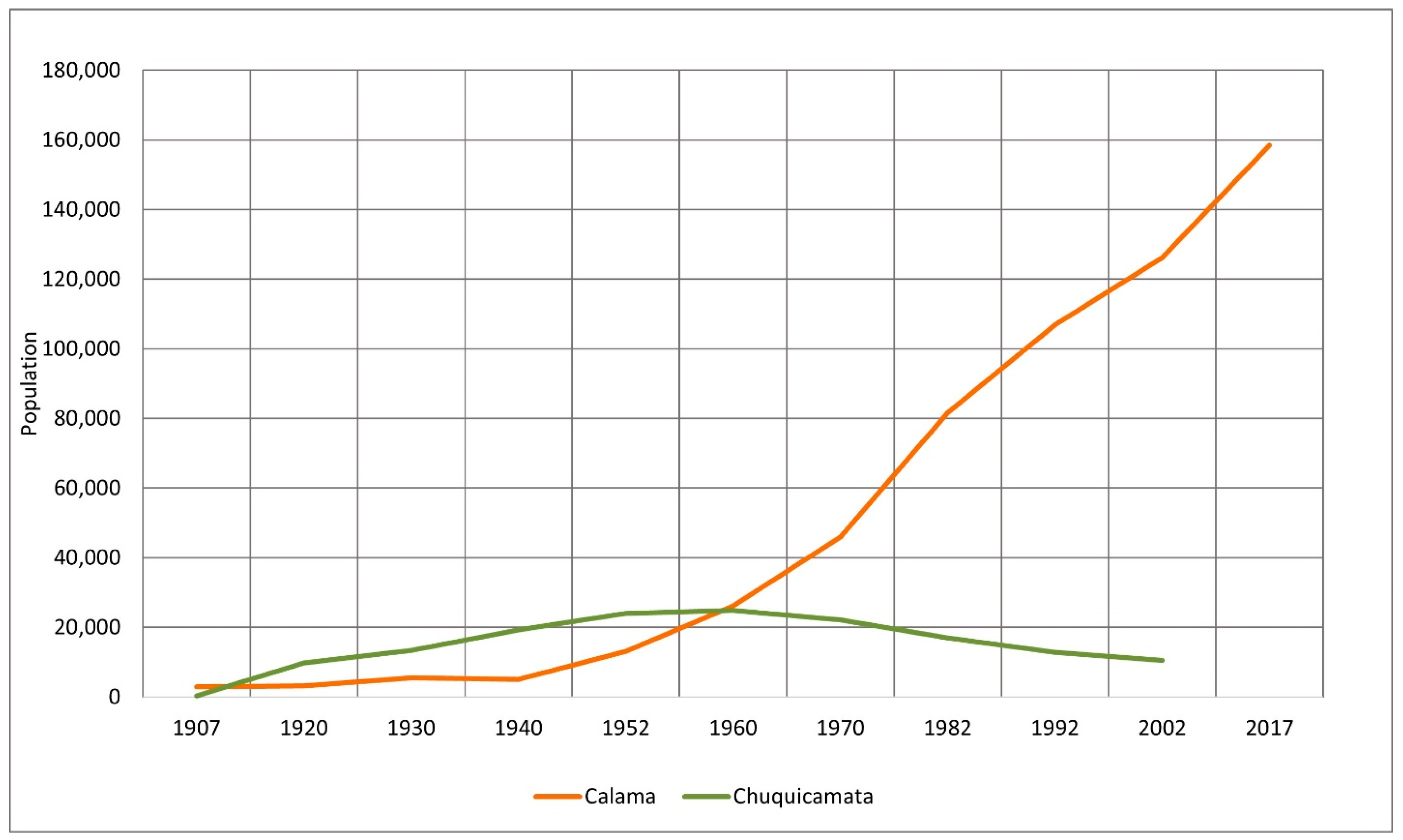
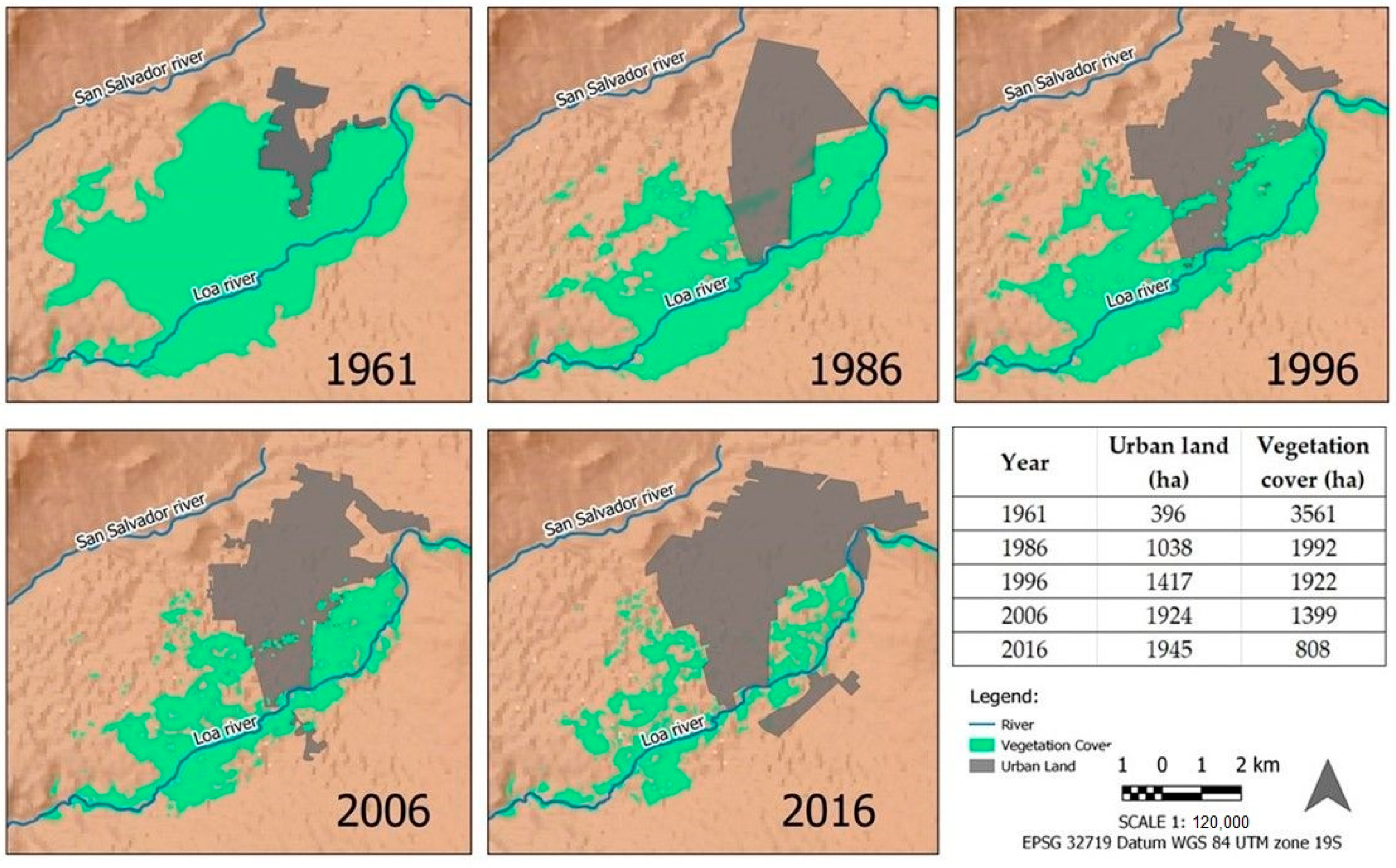
4.2. Urban Growth
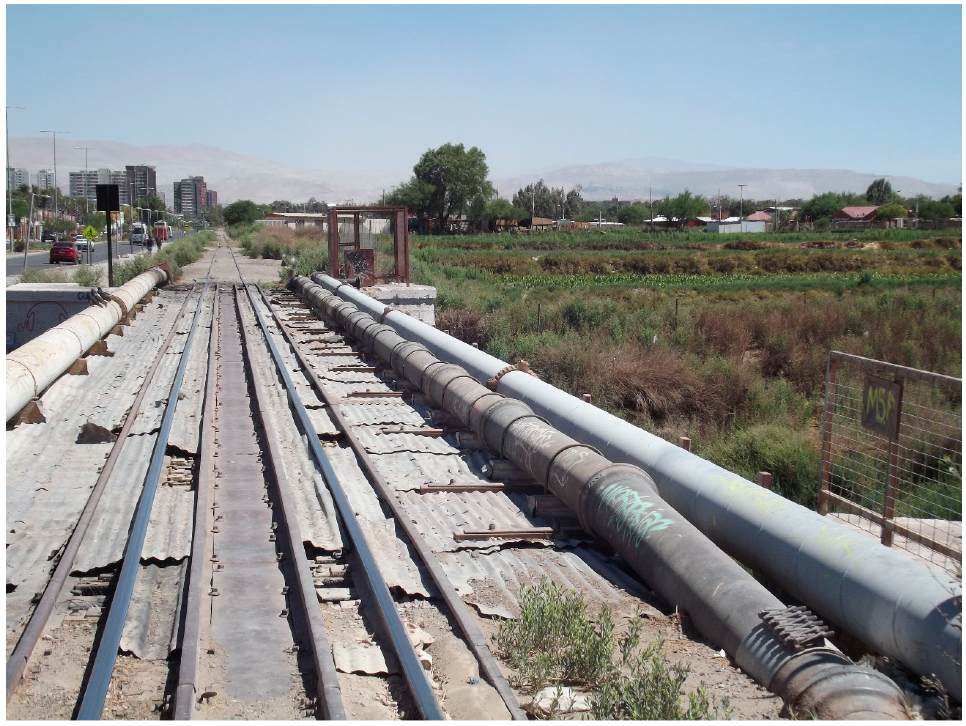
4.3. The Access to Water Resources
5. Agrarian Change and Deagrarianization
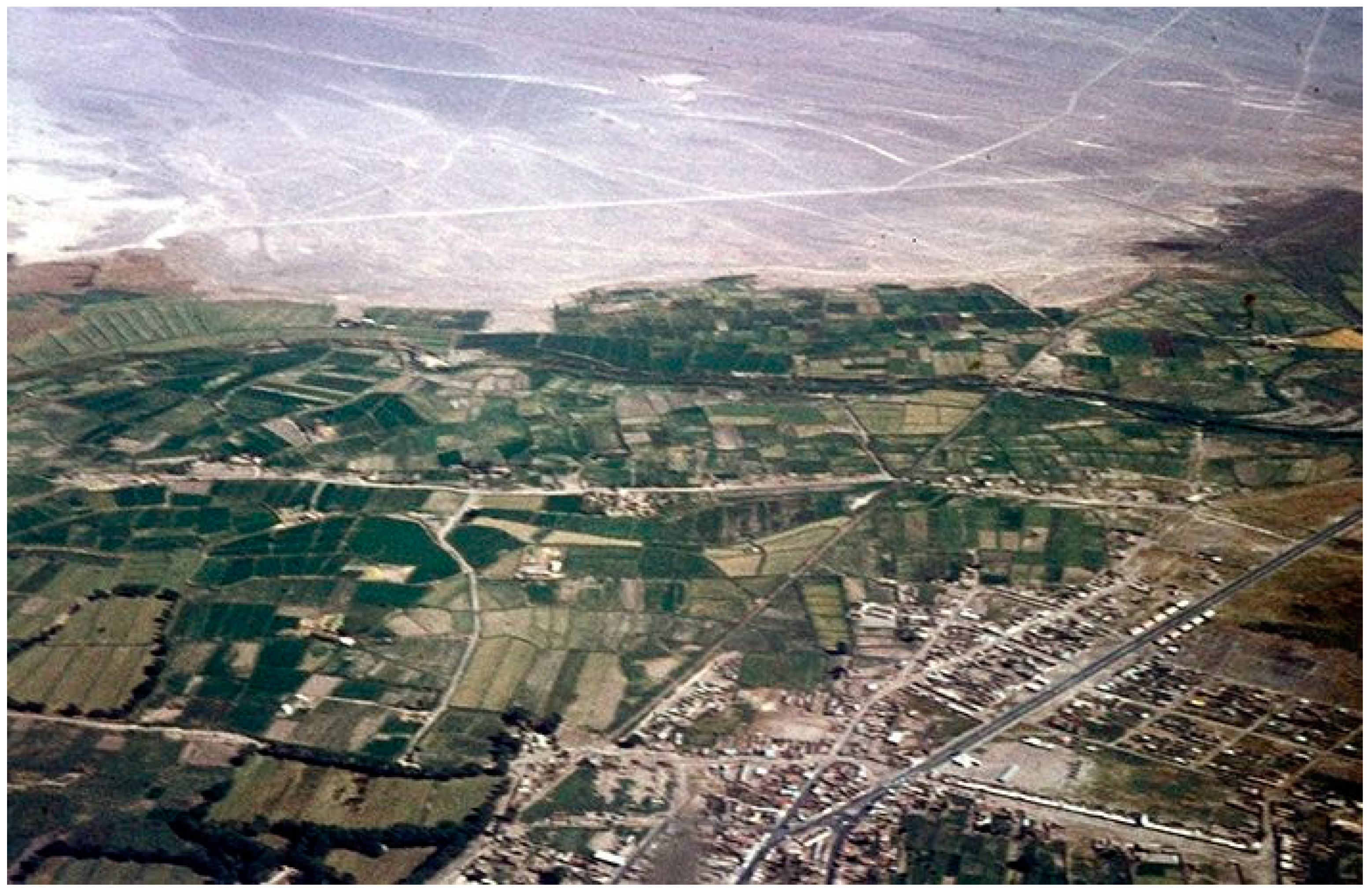
5.1. Agricultural and Livestock Activities before the Development of Large-Scale Copper Mining
5.2. The First Half of the 20th Century: Urban-Extractive Food Markets and Agricultural and Livestock Dynamism
5.3. The Second Half of the 20th Century to the Present: Changes in the Agricultural and Livestock System and the Deagrarianization
- Urban sprawl into farmlands and vegas, as well as non-agricultural use of rural spaces, the latter by longstanding property owners who have stopped practicing agriculture and new owners who purchased their properties for other purposes (e.g., auto-mechanic shops, parking, tourism).
- Fragmentation of agricultural lands through inheritance, which makes it difficult to practice certain activities because of the extremely small plots.
- The younger generation’s relative lack of interest in farming and raising livestock, as they can obtain higher income from salaried employment or as independent workers in the city, in industry, or the mines. At the same time, family operations cannot afford to hire outside help.
- Lower quality and quantity of water resources owing to urban expansion and mining growth, which drives higher water extraction, causes water pollution, and concentrates water rights outside of the agricultural sector.
- Little regulation or state control of mining, water use, land use planning, and urban growth, in parallel with inadequate support for peasant agriculture.
6. Discussion and Conclusions
Supplementary Materials
Author Contributions
Funding
Institutional Review Board Statement
Informed Consent Statement
Data Availability Statement
Acknowledgments
Conflicts of Interest
References
- Akram-Lodhi, A.H.; Kay, C. Surveying the agrarian question (part 2): Current debates and beyond. J. Peasant Stud. 2010, 37, 255–284. [Google Scholar] [CrossRef]
- Hebinck, P. De-/re-agrarianisation: Global perspectives. J. Rural Stud. 2018, 61, 227–235. [Google Scholar] [CrossRef]
- Hommes, L.; Boelens, R.; Harris, L.M.; Veldwisch, G.J. Rural–urban water struggles: Urbanizing hydrosocial territories and evolving connections, discourses and identities. Water Int. 2019, 44, 81–94. [Google Scholar] [CrossRef] [Green Version]
- Levien, M.; Watts, M.; Yan, H. Agrarian Marxism. J. Peasant Stud. 2018, 45, 853–883. [Google Scholar] [CrossRef]
- Bendini, M.; Barbosa, J.; Murmis, M.; Tsakoumagkos, P. (Eds.) El Campo en la Sociología Actual: Una Perspectiva Latinoamericana; La Colmena: Buenos Aires, Argentina, 2003; p. 383. [Google Scholar]
- Bengoa, J. (Ed.) Territorios rurales. Movimientos Sociales y Desarrollo Territorial Rural en América Latina; Catalonia: Santiago, Chile, 2007; p. 613. [Google Scholar]
- Giarraca, N. (Ed.) ¿Una nueva ruralidad en América Latina? CLACSO: Buenos Aires, Argentina, 2001; p. 382. [Google Scholar]
- Hommes, L.; Boelens, R.; Bleeker, S.; Duarte-Abadía, B.; Stoltenborg, D.; Vos, J. Water governmentalities: The shaping of hydrosocial territories, water transfers and rural–urban subjects in Latin America. Environ. Plan. E Nat. Space 2020, 3, 399–422. [Google Scholar] [CrossRef] [Green Version]
- Kay, C. The agrarian question and the neoliberal rural transformation in Latin America. Eur. Rev. Lat. Am. Caribb. Stud. 2015, 100, 73–83. [Google Scholar] [CrossRef] [Green Version]
- Ruiz, N.; Delgado, J. Territorio y nuevas ruralidades: Un recorrido teórico sobre las transformaciones de la relación campo-ciudad. Eure 2008, 34, 77–95. [Google Scholar]
- Bebbington, A.; Bury, J. (Eds.) Subterranean Struggles: New Dynamics of Mining, Oil, and Gas in Latin America; University of Texas Press: Austin, TX, USA, 2013; p. 343. [Google Scholar]
- Burchardt, H.-J.; Dietz, K. (Neo-)extractivism—A new challenge for development theory from Latin America. Third World Q. 2014, 35, 468–486. [Google Scholar] [CrossRef]
- Gudynas, E. Extracciones, extractivismos y extrahecciones. Un marco conceptual sobre la apropiación de recursos naturales. Observatorio del Desarrollo CLAES 2013, 18, 18. [Google Scholar]
- Machado, H. Crítica de la razón progresista. Una mirada marxista sobre el extractivismo/colonialismo del siglo XXI. Actuel. Marx. Interv. 2015, 19, 137–173. [Google Scholar]
- Martín, F. Reimagining Extractivism: Insights from Spatial Theory. In Contested Extractivism, Society and the State; Engels, B., Dietz, K., Eds.; Palgrave Macmillan: Londres, UK, 2017; pp. 21–44. [Google Scholar]
- Perreault, T. Energy, extractivism and hydrocarbon geographies in contemporary Latin America. J. Lat. Am. Geogr. 2018, 17, 235–252. [Google Scholar] [CrossRef]
- Svampa, M. Extractivismo, desarrollo y buen vivir: Visiones en pugna. Actuel. Marx. Interv. 2016, 20, 181–203. [Google Scholar]
- Wallerstein, I. El Capitalismo Histórico; Siglo XXI: México D.F., México, 2003; p. 101. [Google Scholar]
- Amín, S. Capitalismo y sistema-mundo. In Los Desafíos de la Mundialización; Siglo XXI: México D.F., México; Ceiich-Unam: México D.F., México, 1997; pp. 58–94. [Google Scholar]
- Marini, R.M. Dialéctica de la dependencia. In América Latina, Dependencia y Globalización; Siglo XXI: México D.F., México; Clacso: Buenos Aires, Argentina, 2015; pp. 107–149. [Google Scholar]
- Foster, J.; Clark, B. Imperialismo ecológico: La maldición del capitalismo. In Socialist Register; Panitch, L., Leys, C., Eds.; Clacso: San Pablo, Brazil, 2006; pp. 231–250. [Google Scholar]
- Wolf, E. Europa y la Gente Sin Historia; FCE: Buenos Aires, Argentina, 2000; p. 462. [Google Scholar]
- Kay, C.; Vergara-Camus, L. (Eds.) La Cuestión Agraria y los Gobiernos de Izquierda en América Latina; Clacso: Buenos Aires, Argentina, 2018; p. 399. [Google Scholar]
- McKay, B.M.; Alonso-Fradejas, A.; Ezquerro-Cañete, A. (Eds.) Agrarian Extractivism in Latin America; Routledge: New York, NY, USA, 2021; p. 226. [Google Scholar]
- Veltmeyer, H. Resistance, class struggle and social movements in Latin America: Contemporary dynamics. J. Peasant Stud. 2019, 46, 1264–1285. [Google Scholar] [CrossRef]
- Yacoub, C.; Duarte, B.; Boelens, R. (Eds.) Agua y Ecología Política: El Extractivismo en la Agroexportación, la Minería y las Hidroeléctricas en Latinoamérica; Abya-Yala: Quito, Ecuador; Justicia Hídrica: Quito, Ecuador, 2015; p. 312. [Google Scholar]
- Bebbington, A. The New Extraction: Rewriting the Political Ecology of the Andes? NACLA Rep. Am. 2009, 42, 12–20. [Google Scholar] [CrossRef]
- Bebbington, A. (Ed.) Social Conflict, Economic Development and Extractive Industry: Evidence from South America; Routledge: New York, NY, USA, 2012; p. 256. [Google Scholar]
- Bebbington, A. (Ed.) Minería, Movimientos Sociales y Respuestas Campesinas: Una Ecología Política de Transformaciones Territoriales; IEP: Lima, Peru; Cepes: Lima, Peru, 2007; p. 349. [Google Scholar]
- Bebbington, A.; Bebbington, D.; Bury, J.; Lingan, J.; Muñoz, J.; Scurrah, M. Mining and Social Movements: Struggles Over Livelihood and Rural Territorial Development in the Andes. World Dev. 2008, 36, 2888–2905. [Google Scholar] [CrossRef]
- Alimonda, H. (Ed.) La Naturaleza Colonizada. Ecología Política y Minería en América Latina; CICCUS: Buenos Aires, Argentina; Clacso: Buenos Aires, Argentina, 2011; p. 331. [Google Scholar]
- Assadourian, S.; Bonilla, H.; Mitre, A.; Platt, T. Minería y Espacio Económico en Los Andes. Siglos XVI-XX; Instituto de Estudios Peruanos: Lima, Peru, 1980; p. 103. [Google Scholar]
- Budds, J.; Hinojosa, L. Restructuring and rescaling water governance in mining contexts: The co-production of waterscapes in Peru. Water Altern. 2012, 5, 119–137. [Google Scholar]
- Delgado-Ramos, G. (Ed.) Ecología Política de la Minería en América Latina; Universidad Nacional Autónoma de México: México D.F., México, 2010; p. 520. [Google Scholar]
- Göbel, B.; Ulloa, A. (Eds.) Extractivismo Minero en Colombia y América Latina; Universidad Nacional de Colombia: Bogota, Colombia; Berlin Ibero-Amerikanisches Institut: Berlin, Germany, 2014; p. 518. [Google Scholar]
- Perreault, T. Mining and development in Latin America. In The Routledge Handbook of Latin American Development; Cupples, J., Palomino-Schalscha, M., Prieto, M., Eds.; Routledge: London, UK, 2018; pp. 421–431. [Google Scholar]
- Bury, J.; Kolff, A. Livelihoods, mining and peasant protests in the Peruvian Andes. J. Lat. Am. Geogr. 2002, 1, 3–16. [Google Scholar] [CrossRef] [Green Version]
- Perreault, T. Dispossession by accumulation? Mining, water and the nature of enclosure on the Bolivian Altiplano. Antipode 2013, 45, 1050–1069. [Google Scholar] [CrossRef]
- Perreault, T. (Ed.) Minería, Agua y Justicia Social en Los Andes. Experiencias Comparativas de Perú y Bolivia; Justicia Hídrica: Lima, Peru; Fundación Pieb: La Paz, Bolivia, 2014; p. 235. [Google Scholar]
- Contreras, C. Mineros y Campesinos en Los Andes. Mercado Laboral y Economía Campesina en la Sierra Central. Siglo XIX; IEP: Lima, Peru, 1988; p. 155. [Google Scholar]
- Long, N.; Roberts, B. Miners, Peasants and Entrepreneurs. Regional Development in the Central Highlands of Peru; Cambridge University Press: New York, NY, USA, 1984; p. 288. [Google Scholar]
- Parodi, M.; Benedetti, A. Minería, descampesinización y desocupación. Trayectorias de movilidad de cuatro mineros de el aguilar (Jujuy, Argentina, Década de 1940 a 2010). Estud. Atacamenos 2016, 52, 25–48. [Google Scholar] [CrossRef] [Green Version]
- Comisión Chilena del Cobre. Anuario de Estadísticas Del Cobre y Otros Minerales 2000–2019; Comisión Chilena del Cobre: Santiago, Chile, 2020; p. 161. [Google Scholar]
- Sutulov, A. Antecedentes históricos de la producción de cobre en Chile. In El Cobre Chileno; Codelco, Ed.; Universitaria: Santiago, Chile, 1975; pp. 1–61. [Google Scholar]
- Servicio Nacional de Geología y Minería. In Anuario de la Minería de Chile 2019; Servicio Nacional de Geología y Minería: Santiago, Chile, 2020; p. 283.
- Millán, A. La Minería Metálica en Chile en el Siglo XX; Universitaria: Santiago, Chile, 2006; p. 178. [Google Scholar]
- Arriaza, B.; Galaz-Mandakovic, D. Expansión minera, déficit hídrico y crisis sanitaria. La potabilización del río Toconce y el impacto del arsenicismo en la población de la provincia de Antofagasta (1915–1971). Hist. 396 2020, 10, 71–112. [Google Scholar]
- Rudolph, W. The Rio Loa of Northern Chile. Geogr. Rev. 1927, 17, 553–585. [Google Scholar] [CrossRef]
- Rudolph, W. Chuquicamata Twenty Years Later. Geogr. Rev. 1951, 41, 88–113. [Google Scholar] [CrossRef]
- Yáñez, N.; Molina, R. Las Aguas Indígenas en Chile; LOM: Santiago, Chile, 2011; p. 275. [Google Scholar]
- Calderón, M.; Prieto, M. La Cuestión agraria y el cobre en la Provincia de El Loa (1929/30–2006/07). Andes centro-sur, norte de Chile. Estud. Atacamenos 2020, 66, 387–417. [Google Scholar] [CrossRef]
- Carrasco, A. A Biography of Water in Atacama, Chile: Two Indigenous Community Responses to the Extractive Encroachments of Mining. J. Lat. Am. Caribb. Anthropol. 2016, 21, 130–150. [Google Scholar] [CrossRef]
- Castro, V.; Martinez, J. Poblaciones indígenas de Atacama. In Culturas de Chile. Etnografía Sociedades Indígenas Contemporáneas y su Ideología; Hidalgo, J., Schiappacasse, V., Niemeyer, H., Aldunate, C., Mege, P., Eds.; Andrés Bello: Santiago, Chile, 1996; pp. 69–109. [Google Scholar]
- Prieto, M.; Salazar, D.; Valenzuela, M. The dispossession of the San Pedro de Inacaliri river: Political Ecology, extractivism and archaeology. Extr. Ind. Soc. 2019, 6, 562–572. [Google Scholar] [CrossRef]
- Villagrán, C.; Castro, V. Etnobotánica y manejo ganadero de las vegas, bofedales y quebradas en el Loa Superior, Andes de Antofagasta, Segunda Región, Chile. Chungara 1997, 29, 275–304. [Google Scholar]
- Navarro-Gonzalez, R.; Rainey, F.; Molina, P.; Bagaley, D.; Hollen, B.; de la Rosa, J.; Small, A.M.; Quinn, R.C.; Grunthaner, F.J.; Cáceres, L.; et al. Mars-Like Soils in the Atacama Desert, Chile, and the Dry Limit of Microbial Life. Science 2003, 302, 1018–1021. [Google Scholar] [CrossRef] [Green Version]
- Romero, H.; Smith, P.; Mendoca, M.; Méndez, M. Macro y mesoclimas del altiplano andino y desierto de Atacama: Desafíos y estrategias de adaptación social ante su variabilidad. Rev. Geogr. Norte Gd. 2013, 55, 19–41. [Google Scholar] [CrossRef] [Green Version]
- Sarricolea, P.; Herrera-Ossandon, M.; Meseguer-Ruiz, O. Climatic regionalisation of continental Chile. J. Maps 2017, 13, 66–73. [Google Scholar] [CrossRef]
- Marquet, P.; Bozinovic, F.; Bradshaw, G.; Cornelius, C.; Gonzalez, H.; Gutierrez, J.R.; Hajek, E.R.; Lagos, J.A.; Lopez-Cortes, F.; Nuñez, L.; et al. Los ecosistemas del desierto de Atacama y área andina adyacente en el norte de Chile. Rev. Chil. Hist. Nat. 1998, 71, 593–617. [Google Scholar]
- Aldunate, C.; Berenguer, J.; Castro, V.; Cornejo, L.; Martínez, J.; Sinclaire, C. Sobre la cronología del Loa superior. Chungara 1986, 16–17, 333–346. [Google Scholar]
- Gundermann, H. Pastoralismo andino y transformaciones sociales en el norte de Chile. Estud. Atacamenos 1998, 16, 293–319. [Google Scholar] [CrossRef] [Green Version]
- Instituto Nacional de Estadísticas. Censo de Población y Vivienda 2017. Available online: https://www.ine.cl/estadisticas/sociales/censos-de-poblacion-y-vivienda/poblacion-y-vivienda (accessed on 19 January 2018).
- García, M. Socioestadística. Introducción a la Estadística en Sociología; Alianza: Madrid, Spain, 1985; p. 491. [Google Scholar]
- Araya, L. Los Derechos de Uso de Agua de los Agricultores de Calama ¿son Efectivos? Master’s Thesis, Pontificia Universidad Católica de Chile, Santiago, Chile, 2006. [Google Scholar]
- Orellana, L. La lucha de los mineros contra las leyes: Chuquicamata (1900–1915). Hist. Santiago 2004, 1, 169–206. [Google Scholar]
- Departamento del cobre. In El cobre en Chile; Editorial Universitaria: Santiago, Chile, 1959; p. 63.
- Vergara, A. Conflicto y Modernización en la Gran Minería del Cobre (1950–1970). Hist. Santiago 2004, 37, 419–436. [Google Scholar]
- El Mercurio de Calama. Chuquicamata, Piedra Angular en la Nacionalización Del Cobre; El Mercurio de Calama: Calama, Chile, 18 July 1971; p. 10. [Google Scholar]
- El Mercurio de Calama. Chuquicamata Depende Ahora de la Conciencia de Los Trabajadores; El Mercurio de Calama: Calama, Chile, 19 July 1971; p. 2. [Google Scholar]
- Gaudichaud, F. Las Fisuras Del Neoliberalismo Chileno. Trabajo, Crisis de la “Democracia Tutelada” y Conflictos de Clases; Quimantú: Santiago, Chile; Tiempo Robado: Santiago, Chile, 2015; p. 132. [Google Scholar]
- González, R. Tres décadas de un nuevo orden económico, Chile: 1973–2003. Eur. Rev. Lat. Am. Caribb. Stud. 2004, 77, 61–77. [Google Scholar] [CrossRef]
- Harvey, D. Breve Historia Del Neoliberalismo; Akal: Madrid, Spain, 2007; p. 245. [Google Scholar]
- Guajardo, J. La Agenda Minera en Chile: Revisión y Perspectivas; CEPAL: Santiago, Chile, 2007; p. 60. [Google Scholar]
- Yáñez, N.; Molina, R. La Gran Minería y Los Derechos Indígenas en el Norte de Chile; LOM: Santiago, Chile, 2008; p. 264. [Google Scholar]
- Comisión Chilena del Cobre. Bases de Datos. Available online: https://www.cochilco.cl/Paginas/Estadisticas/BasesdeDatos/Bases-de-Datos.aspx (accessed on 7 September 2020).
- El Mercurio de Calama. Ola de Récords se Logra en el Mineral; El Mercurio de Calama: Calama, Chile, 1971; p. 10. [Google Scholar]
- El Mercurio de Calama. Cobrechuqui Alcanza Los Índices de Producción Más Altos de su Historia; El Mercurio de Calama: Calama, Chile, 1973; p. 9. [Google Scholar]
- O’Ryan, F. Tras 104 años de Operación Continua a RAJO abierto, Chuquicamata es Inaugurada Oficialmente Como Mina Subterránea. Tercera 2019. Available online: https://www.latercera.com/pulso/noticia/tras-104-anos-operacion-continua-rajo-abierto-chuquicamata-inaugurada-oficialmente-mina-subterranea/782721/ (accessed on 8 October 2021).
- Galaz-Mandakovic, D.; Rivera, F. Bolivianos y bolivianas en Chuquicamata. Caracterización de los flujos migratorios desde el período de la minería artesanal a la era industrial (1881–1942). Rev. Hist. 2021, 28, 146–185. [Google Scholar] [CrossRef]
- Figueroa, O.; Contreras, Y. El proceso de metropolización en la ciudad de Antofagasta. In Chile: Del País Urbano al País Metropolitano; Hidalgo, R., de Mattos, C., Arenas, F., Eds.; Pontificia Universidad Católica de Chile: Santiago, Chile, 2009; pp. 133–148. [Google Scholar]
- Garcés, E.; O’Brien, J.; Cooper, M. Del asentamiento minero al espacio continental chuquicamata (Chile) y la contribución de la minería a la configuración del territorio y el desarrollo social y económico de la Región de Antofagasta durante el siglo XX. Eure 2010, 36, 93–108. [Google Scholar]
- El Mercurio de Calama. Modernas Viviendas Para Personal de Chuquicamata Construirán de Calama; El Mercurio de Calama: Calama, Chile, 1968; pp. 1, 7. [Google Scholar]
- El Mercurio de Calama. Anaconda Proyecta Construir Más de 5 Mil Casas en la Zona Norte; El Mercurio de Calama: Calama, Chile, 1969; p. 7. [Google Scholar]
- El Mercurio de Calama. Nuevas Poblaciones se Construyen en Calama; El Mercurio de Calama: Calama, Chile, 1970; p. 16. [Google Scholar]
- Bahr, J. Agriculture, copper mining, and migration in the Andean Cordillera of northern Chile. Mt. Res. Dev. 1985, 5, 279–290. [Google Scholar] [CrossRef]
- Calderón, M.; Miranda, F. Análisis de la variación de la superficie de campamentos (2011–2017), caracterización y transformación del paisaje en las comunas de Antofagasta, Calama, Copiapó y Viña del Mar. Sustain. Agri Food Environ. Res. 2018, 6, 55–73. [Google Scholar] [CrossRef]
- El Mercurio de Calama. Creciente Auge Experimenta Autoconstrucción en Calama; El Mercurio de Calama: Calama, Chile, 1970; p. 2. [Google Scholar]
- Rasheed, K.B.S. Depopulation of the Oases in Northern Chile. Rev. Geográfica 1971, 74, 101–113. [Google Scholar]
- El Mercurio de Calama. Solucionarán Problemas de Las Poblaciones Marginales; El Mercurio de Calama: Calama, Chile, 1968; p. 10. [Google Scholar]
- Mondaca, C.; Ogalde, J.P. Historia y Memoria de la Comunidad Atacameña de La Banda. Calama, Norte de Chile, Siglos XIX y XX; CNCA: Calama, Chile, 2012; p. 180. [Google Scholar]
- Pérez, G.; Pavez, C.; Jiménez, J. Ordenamiento territorial y sustentabilidad de un oasis. El caso del seccional Topater en Calama. Urbano 2008, 11, 7–14. [Google Scholar]
- Vergara, F. ¿Hacia un nuevo Modelo de Gobernanza en Chile? Análisis Territorial y Relacional de los Planes Maestros PRES Constitución y Calama Plus. Bachelor’s Thesis, Universidad de Chile, Santiago, Chile, 2018. [Google Scholar]
- Penaglia, F.; Valenzuela, E. Rebeldía en Calama: Desafío al orden centralista chileno en un contexto de boom minero. Rev. Mex. Cienc. Políticas Soc. 2014, 59, 161–186. [Google Scholar]
- El Mercurio de Calama. La Ley de “Loteos Brujos” Analiza el MINVU en Calama; El Mercurio de Calama: Calama, Chile, 1969; p. 7. [Google Scholar]
- El Mercurio de Calama. Gobernador Pidió al Ministerio de Agricultura Intervención de CORA; El Mercurio de Calama: Calama, Chile, 1970; p. 2. [Google Scholar]
- El Mercurio de Calama. Construyen Viviendas en los Predios Agrícolas Calama; El Mercurio de Calama: Calama, Chile, 1971; p. 6. [Google Scholar]
- El Mercurio de Calama. Anuncian Defensa Para los Agricultores de Cerro Negro; El Mercurio de Calama: Calama, Chile, 1969; p. 1. [Google Scholar]
- El Mercurio de Calama. Diputado Soto Pide: Que no se Destinen Áreas Cultivables de Calama a los Grupos Habitacionales; El Mercurio de Calama: Calama, Chile, 1971; p. 2. [Google Scholar]
- Carrasco, A.; Fernández, E. Estrategias de resistencia indígena frente al desarrollo minero. La comunidad de likantatay ante un posible traslado forzoso. Estud. Atacamenos 2009, 38, 75–92. [Google Scholar] [CrossRef]
- Blázquez, P. El agua del Loa Superior; 1888–1920. Administración Estatal de un Recurso Escaso o Sobre Cómo y por Qué Razón Buena Parte del Agua que Daba Vida a Unos Cuantos Indios fue a Parar a los Calderos de las Mineras y a los Caños de las Ciudades. Bachelor’s Thesis, Pontificia Universidad Católica de Chile, Santiago, Chile, 1999. [Google Scholar]
- Figueiredo Ferraz Consultoría e Ingeniería de Proyecto Ltda. Análisis de la Oferta y Demanda de Recursos Hídricos en Cuencas Críticas de Loa, Rapel y Mataquito. Volúmen I. Cuenca Del Río Loa; Dirección General de Aguas: Santiago, Chile, 1996; p. 217. [Google Scholar]
- Lira, G. Aguas del río Loa; Instituto Científico e Industrial del Salitre: Santiago, Chile, 1921; p. 30. [Google Scholar]
- Cuadra, M. Teoría y práctica de los derechos ancestrales de agua de las comunidades atacameñas. Estud. Atacamenos 2000, 19, 93–112. [Google Scholar] [CrossRef] [Green Version]
- Prieto, M.; Calderón, M.; Fragkou, M.C.; Fuster, R. The (Not-so-Free) Chilean Water Model. The Case of the Antofagasta Region, Atacama Desert, Chile. Extr. Ind. Soc. 2021. manuscript submitted. [Google Scholar]
- Bauer, C. Contra la Corriente. Privatización, Mercados de Agua y el Estado en Chile; LOM: Santiago, Chile, 2002; p. 207. [Google Scholar]
- El Mercurio de Calama. Escasez de Agua para Regadío Pone en Peligro a Oasis de Calama y Quillagua; El Mercurio de Calama: Calama, Chile, 1970; p. 2. [Google Scholar]
- Bauer, C. Canto de Sirenas. El Derecho de Aguas Chileno Como Modelo Para Reformas Internacionales; Ediciones El Desconcierto.cl: Santiago, Chile, 2015; p. 319. [Google Scholar]
- Prieto, M. La Ecología (a)Política del modelo de aguas chileno. In Ecología Política en Chile Naturaleza, Propiedad, Conocimiento y Poder; Bustos, B., Prieto, M., Barton, J., Eds.; Universitaria: Santiago, Chile, 2015; pp. 143–164. [Google Scholar]
- Prieto, M. El Riego que el Mercado no Quiere Ver: Historia del Despojo Hídrico en las Comunidades de Lasana y Chiu-Chiu (Desierto de Atacama, Chile). J. Lat. Am. Geogr. 2017, 16, 69–91. [Google Scholar] [CrossRef]
- Niemeyer, H. Estudio de Racionalización Del Área de Riego Del Río Loa. II Región de Chile; Dirección General de Aguas: Santiago, Chile, 1979; p. 245. [Google Scholar]
- Verzijl, A.; Quispe, S.G. The System Nobody Sees: Irrigated Wetland Management and Alpaca Herding in the Peruvian Andes. Mt. Res. Dev. 2013, 33, 280–293. [Google Scholar] [CrossRef]
- Prieto, M. Transando el agua, produciendo territorios e identidades indígenas: El modelo de aguas chileno y los atacameños de Calama. Rev. Estud. Soc. 2016, 55, 88–103. [Google Scholar] [CrossRef]
- Dirección General de Aguas. Declara Agotamiento Del Río Loa y Sus Afluentes. II Región (Res.Ex. 197, 2000). Available online: https://dga.mop.gob.cl/administracionrecursoshidricos/asuperficiales/Documents/Resolucionloa.pdf (accessed on 5 February 2021).
- Gutiérrez, E.; Figueroa, M. Chuquicamata, su Grandeza y Sus Dolores; Imprenta Cervantes: Santiago, Chile, 1920; p. 199. [Google Scholar]
- Barros, A. Identidades y propiedades: Transiciones territoriales en el siglo XIX atacameño. Estud. Atacamenos 2008, 35, 119–139. [Google Scholar] [CrossRef]
- Sanhueza, C.; Gundermann, H. Estado, expansión capitalista y sujetos sociales en Atacama (1879–1928). Estud. Atacamenos 2007, 34, 113–136. [Google Scholar] [CrossRef]
- Risopatrón, L. El problema del Salado en la hoya del Loa. An. Del Inst. Ing. Chile 1905, V, 1–22. [Google Scholar]
- Bowman, I. Los Senderos Del Desierto de Atacama; Sociedad Chilena de Historia y Geografía: Santiago, Chile, 1942; p. 421. [Google Scholar]
- Rivera, F.; González, P.; Lorca, R.; Faundes, W. Assessing the industrial past in the highlands of northern Chile. J. Community Archaeol. Herit. 2021, 8, 26–42. [Google Scholar] [CrossRef]
- González, S. “Normalización” de la crisis y posición estratégica empresarial durante la expansión de la economía del salitre. Polis 2015, 14, 397–419. [Google Scholar] [CrossRef] [Green Version]
- Consecol Ltda. Diagnóstico Agrícola Provincia de El Loa, II Región. Informe Final (2 Tomos); Consecol: Santiago, Chile, 1988; p. 267. [Google Scholar]
- El Mercurio de Calama. Grave Problema Crea a Agricultores la Falta de Mercado Para la Alfalfa; El Mercurio de Calama: Calama, Chile, 1970; p. 1. [Google Scholar]
- El Mercurio de Calama. Creación de Estaciones Agrícolas en Chiu-Chiu, Calama y Lasana, Estudia Intendente; El Mercurio de Calama: Calama, Chile, 1969; p. 2. [Google Scholar]
- Chonchol, J. Sistemas Agrarios en América Latina. De la Etapa Prehispánica a la Modernización Conservadora; FCE: Santiago, Chile, 1996; p. 445. [Google Scholar]
- El Mercurio de Calama. Solucionarán Problemas de Sector de Chunchuri; El Mercurio de Calama: Calama, Chile, 1968; p. 1. [Google Scholar]
- El Mercurio de Calama. Mañana Finalizarán Los Seminarios Sobre Capacitación de Campesinos; El Mercurio de Calama: Calama, Chile, 1968; p. 2. [Google Scholar]
- El Mercurio de Calama. Pronto Estarán Terminadas Las Faenas de Canalización; El Mercurio de Calama: Calama, Chile, 1969; p. 1. [Google Scholar]
- El Mercurio de Calama. El Sábado se Formará en CALAMA el Sindicato Campesino de El Loa; El Mercurio de Calama: Calama, Chile, 1970; p. 2. [Google Scholar]
- El Mercurio de Calama. Títulos de Dominio Para Agricultores Del Sector Chunchuri; El Mercurio de Calama: Calama, Chile, 1972; p. 10. [Google Scholar]
- El Mercurio de Calama. Embalse de Conchi Aumentará Caudal de Agua Para Riego; El Mercurio de Calama: Calama, Chile, 1973; p. 7. [Google Scholar]
- El Mercurio de Calama. La CORA Expropió 8 Fincas en Calama; El Mercurio de Calama: Calama, Chile, 1971; p. 2. [Google Scholar]
- El Mercurio de Calama. Posible Sesión en Calama del Consejo de la CORA; El Mercurio de Calama: Calama, Chile, 1971; p. 1. [Google Scholar]
- Gómez, S.; Echeñique, J. La Agricultura Chilena. Las dos Caras de la Modernización; FLACSO/Agraria: Santiago, Chile, 1988; p. 304. [Google Scholar]
- El Mercurio de Calama. Entregaran Títulos de Dominio a Campesinos de Los Asentamientos; El Mercurio de Calama: Calama, Chile, 1973; p. 10. [Google Scholar]
- Castaño Gea, J. Estudio Básico. Diagnóstico recursos Hídricos en Riego Sustentable Cuenca Loa y Salado. Informe Final; Comisión Nacional de Riego: Santiago, Chile, 2017; p. 784. [Google Scholar]
- Valenzuela, A. Atacameños de Calama. Diversidad, Transitoriedad y fragmentación en las Organizaciones Atacameñas Urbanas y su Relación con el Estado Chileno. Master’s Thesis, Centro de Investigaciones y Estudios Superiores en Antropología Social, Guadalajara, México, 2006. [Google Scholar]
- Correa, F. Asentamientos Extractivos en América Del Sur. Un Urbanismo Más Allá de la Ciudad; Editorial Reverté: Barcelona, Spain, 2018; p. 196. [Google Scholar]
- Calderón, J.; Vega, P. La cuestión urbana en Perú: Balance y perspectivas para el siglo XXI. In La Cuestión Urbana en la Región Andina: Miradas Sobre la Investigación y la Formación; Metzger, P., Rebotier, J., Robert, J., Urquieta, P., Vega, P., Eds.; Pontificia Universidad Católica del Ecuador: Quito, Ecuador, 2016; pp. 175–221. [Google Scholar]
- Urquieta, P. Avances y desafíos de la investigación y la formación en temas urbanos en Bolivia. In La Cuestión Urbana en la Región Andina: Miradas Sobre la Investigación y la Formación; Metzger, P., Rebotier, J., Robert, J., Urquieta, P., Vega, P., Eds.; Pontificia Universidad Católica del Ecuador: Quito, Ecuador, 2016; pp. 21–75. [Google Scholar]


Publisher’s Note: MDPI stays neutral with regard to jurisdictional claims in published maps and institutional affiliations. |
© 2021 by the authors. Licensee MDPI, Basel, Switzerland. This article is an open access article distributed under the terms and conditions of the Creative Commons Attribution (CC BY) license (https://creativecommons.org/licenses/by/4.0/).
Share and Cite
Calderón-Seguel, M.; Prieto, M.; Meseguer-Ruiz, O.; Viñales, F.; Hidalgo, P.; Esper, E. Mining, Urban Growth, and Agrarian Changes in the Atacama Desert: The Case of the Calama Oasis in Northern Chile. Land 2021, 10, 1262. https://0-doi-org.brum.beds.ac.uk/10.3390/land10111262
Calderón-Seguel M, Prieto M, Meseguer-Ruiz O, Viñales F, Hidalgo P, Esper E. Mining, Urban Growth, and Agrarian Changes in the Atacama Desert: The Case of the Calama Oasis in Northern Chile. Land. 2021; 10(11):1262. https://0-doi-org.brum.beds.ac.uk/10.3390/land10111262
Chicago/Turabian StyleCalderón-Seguel, Matías, Manuel Prieto, Oliver Meseguer-Ruiz, Freddy Viñales, Paulina Hidalgo, and Elías Esper. 2021. "Mining, Urban Growth, and Agrarian Changes in the Atacama Desert: The Case of the Calama Oasis in Northern Chile" Land 10, no. 11: 1262. https://0-doi-org.brum.beds.ac.uk/10.3390/land10111262