Article

User VR Experience and Motivation Study in an Immersive 3D Geovisualization Environment Using a Game Engine for Landscape Design Teaching

by
Carlos Carbonell-Carrera
1,*,
Jose Luis Saorin
2 and
Dámari Melián Díaz
2
1
Department of Techniques and Projects in Engineering and Architecture, Area of Cartographic, Geodetic and Photogrammetry Engineering, Universidad de La Laguna, 38200 San Cristóbal de La Laguna, Santa Cruz de Tenerife, Spain
2
Department of Techniques and Projects in Engineering and Architecture, Area of Engineering Graphics, Universidad de La Laguna, 38200 San Cristóbal de La Laguna, Santa Cruz de Tenerife, Spain
*
Author to whom correspondence should be addressed.
Submission received: 17 April 2021 / Revised: 29 April 2021 / Accepted: 2 May 2021 / Published: 6 May 2021
(This article belongs to the Special Issue 3D Geovisualization in Landscape Design)

Abstract

:
Realistic 3D geovisualization is necessary to facilitate the perception of a landscape designer in relation to the environment, which is a determining factor in decision-making in landscape planning and management. In the field of landscape design teaching learning environments, game engines can offer an immersive 3D geovisualization mode through Virtual Reality technology, which, in addition, can be motivating for the student. Game engines allow designing the scenarios where videogames take place, but game engines can also be used for geovisualization tasks in landscape design teaching environments. In this article, we present the landscape workshop, using a Unity 3D game engine. Twenty-five architect students performed landscape design tasks and worked with an interactive 3D geovisualization low-immersive desktop screen environment. The perception of the 3D environment during geovisualization was analyzed through the Questionnaire on User eXperience in Immersive Virtual Environments, and the motivational factor with the Intrinsic Motivation Inventory. Results showed a high perception of the 3D environment during geovisualization in the nine subcategories (sense of presence, engagement, immersion, flow, usability, emotion, judgment, experience consequence, and technology adoption) analyzed. The game engine-based teaching approach carried out has been motivating for students, with values over 5 (in a 1–7 Likert scale) in the five subscales considered.

1. Introduction

Landscape planning and landscape design/architecture tasks require geospatial information from the environment, which has traditionally been represented through 2D topographic maps, the most common of cartographic products [1]. For 3D terrain representation, maps use different cartographic techniques, which are abstract geographic representations such as contour lines, shading, or hypsometric inks, among others. In this way, topographic maps provide an abstract geographic representation of the Earth’s surface [2]. The inventory of landforms and surface structures provided by maps has been used as a research tool for landscape analysis and design [3].
When visualizing a map, it is necessary for the landscape designer to know how to interpret these cartographic techniques to perceive, in the two-dimensional environment in which a map develops, the three-dimensional reality of the topographic relief. Punia and Kundu affirmed “not everybody can read maps or reconstruct mentally a 3D landscape from a 2D-map image” [4]. However, there are also other challenges for the landscape professional. The maps can also combine the geospatial information through multiple views (profile views, elevations, thematic data, etc.) that simultaneously show multivariate geospatial data in separate but dynamically linked views. This cartographic representation of geographic information, although it is a widely used way to represent the geographic environment [5], requires an added effort for its interpretation [6].
These circumstances pose an added difficulty in teaching–learning environments, since the effort in geospatial visualization (geovisualization) can cause frustration among students, reducing their motivation. New 3D rendering technologies can facilitate the tasks of visualizing the landscape environment. Technologies such as Virtual Reality (VR) can help the landscape design teacher to plan strategies that stimulate the 3D visualization of the terrain. Three-dimensional geographic representations through VR can offer a 3D terrain visualization environment that does not require multiple views, by being able to view plan, elevation, and even geospatial information simultaneously. In addition, they do not require the interpretation of any cartographic technique for the visualization of the landforms. Virtual reality offers a geographic 3D representation of the environment that can be easier for the user to perceive and be motivating for the landscape design student. Research in the teaching field highlights the potential of Virtual Reality environments in teaching–learning processes [7,8]. Evaluations of VR from the educational point of view have been focused on factors such as interaction, the sense of immersion (immersive virtual environments, iVE) and motivation, among others [9]. An immersive virtual environment is “an interactive smart computer-based system that provides a three-dimensional virtual world” [10]. However, although immersive virtual learning environments (iVLE) are considered a powerful educational tool [11,12], numerous authors think there is a need for more research in this field [11,13,14,15,16,17].
In landscape design/architecture, the three-dimensional visualization consists of a realistic 3D terrain visualization of the geographical environment, which is known as 3D geovisualization that is, 3D geographic visualization. The term geovisualization integrates, in addition to the realistic visualization of the geographic environment, the representation of geospatial information, spatial data, and/or thematic information. This geospatial information can have a complex structure that, in addition to involving geographic information (positioning), contains temporal and thematic attributes of the data. An example of an interactive 3D geovisualization of spatial data is the work of Balla et al. [18], who used a new approach that allowed the user to manipulate temporal and spatial environmental data.
The present research focuses exclusively on the realistic 3D geovisualization of the geographic environment, that is, the 3D geographic representation and visualization of terrain using Virtual Reality.
The use of 3D geovisualization tools is standing out in the tasks of understanding landforms and environmental processes [19]. Technologies such as virtual reality offer great opportunities for 3D geovisualization, offering not only a realistic 3D geovisualization scenario but also providing immersion and interaction possibilities. These possibilities provide an intuitive 3D geovisualization and interaction scenario, which allows different stakeholders, with different backgrounds, experience, and training, to work together around a landscape design project. Realistic and immersive 3D geovisualizations are powerful tools to landscape planning and constitute, in turn, a platform for participatory planning of territorial management [19,20,21,22]. Recent works [23] affirm that it is necessary to deep the research on the perception of 3D geovisualizations in the field of landscape and urban planning.
Strategies of collaborative work platforms between different stakeholders in 3D visualization scenarios have been carried out, such as the VirCA (Virtual Collaboration Arena) [24,25,26,27]. This platform allows the design and implementation of collaborative 3D visualization scenarios in which 3D content is actively shared and manipulated in a collaborative and synchronized way. The VirCA system has been used in fields such as neuroscience research and industrial engineering, among others, and it is an example of an interactive collaborative 3D work environment that could be applied to landscape design.
In this context of intuitive, immersive with a sense of presence, and realistic 3D geovisualization, it is necessary to highlight the role that games can play. Many games are played in landscapes, both in virtual mode in 3D games played in a VR scenario and in real mode with location based games. Game engines allow designing the scenarios where videogames take place. Computer game technology, used for serious purposes, is being applied in landscape planning [19]. It is in landscape design teaching–learning environments where game engines can offer an interactive and immersive 3D geovisualization mode in a Virtual Reality environment, which can be motivating for students.
Therefore, it is interesting to study how students perceive the 3D environment during 3D geovisualization using game engines in landscape-design educational environments. The present study can be framed within what authors such as Baryani, Csapo, and Sallai [27] call CogInfoCom, which is an interdisciplinary research field that has emerged as a synergy between info-communications and the cognitive sciences. In this article, we present the landscape workshop, carried out with 25 architect students. In the workshop, designed with Unity 3D (www.unity3d.com, accessed on 5 May 2021) game engine, the participants performed landscape-design tasks and worked with an interactive 3D geovisualization environment. Unity 3D can generate applications in virtual reality (VR) environments in conventional 2D computer screens (low-immersive desktop screen environments) as well as using HDM (head-mounted displays) devices (Figure 1). The present research was carried out in a low-immersive 2D desktop screen environment (Figure 1a). Authors such as Jaalama et al. [23] highlighted the need to research the perception and understanding of reality-based 3D geovisualizations using a 3D geovisualization approach based on a 2D screen.
The perception of the 3D environment during geovisualization was analyzed through the Questionnaire on User eXperience in Immersive Virtual Environments (QUXiVE) [10,28]. The impact of this technology as a motivating element among students was also considered, since it plays a fundamental role in the teaching–learning processes. Keller and Litchfield [29], from the educational approach, defined motivation as the “student’s desire to engage in a learning environment”. The motivational factor was measured with the Intrinsic Motivation Inventory (IMI) [30].

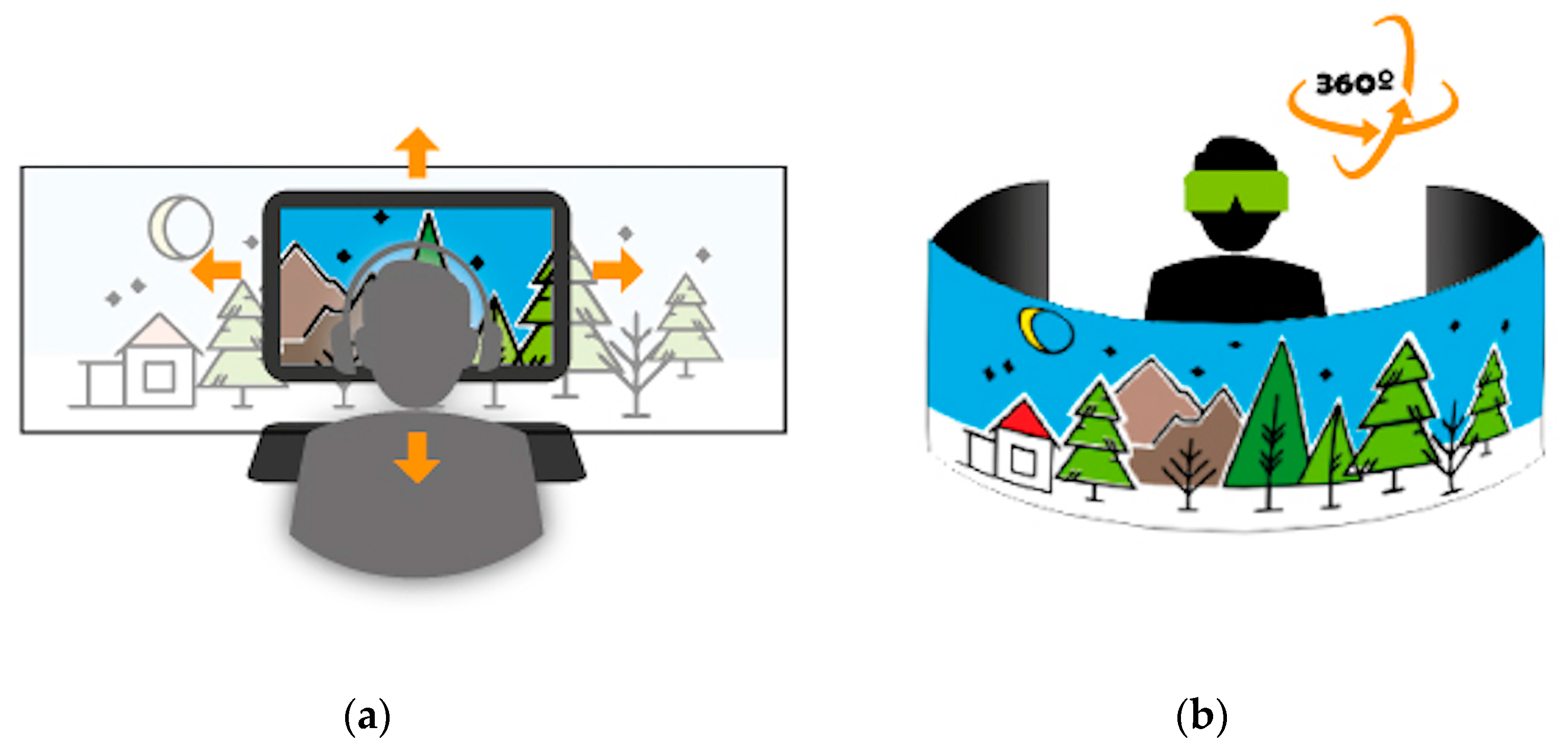
2. The Role of Game Engines in Landscape 3D Geovisualization

In landscape and urban planning, the visualization of the information plays nowadays a decisive role in the decision-making processes [31,32,33,34]. Landscape and environments are a crucial part of the geovisualization [4]. The representation of geospatial information, either in 2D or 3D, is called geospatial data visualization or geovisualization (geographic visualization). Geovisualization integrates scientific visualization [35], information visualization [36], and virtual environments [37]. Therefore, the term geovisualization integrates the geographic representation and visualization of topographic information and geospatial data information. Topographic information plays a fundamental role in geovisualization [3]. This research focuses, within the term geovisualization, on the geographic representation and 3D visualization of the landscape environment, that is, 3D terrain geovisualization. Aspects such as thematic geospatial data information display are not considered in our study.
The realistic 3D geovisualization is necessary to facilitate the perception of people in relation to their environment, which is a determining factor in decision-making in landscape planning and management [38]. Research in technological tools for 3D landscape geovisualization and modeling has increased in the last years [39,40,41,42,43,44,45,46,47,48]. For these purposes, 3D Geographic Information Systems/Computer-Aided-Design (GIS/CAD) systems has been used, although authors such as Purnia and Kundu [4] consider these visualization techniques requires expensive software and specific training, and highlighted the need for a faster and easier method. This is where game engine technology can be an interesting alternative tool, as they are inexpensive and easy to use. A game engine is “a computer game’s software that contains good 3D graphical rendering and representations of physical laws. And last, but by no means least of their advantages for supporting VR simulation, game engines are relatively inexpensive.” [49]. Game engines are made up of a set of tools that allow designing the scenarios where videogames take place, facilitating their operation in a VR display. For educational purposes, there are several free-use games engines such as Unity 3D (https://unity.com/es (accessed on 5 May 2021), which is the one used in the present research), Unreal Engine (https://www.unrealengine.com/en-US/) (accessed on 5 May 2021), Godot Engine (https://godotengine.org/) (accessed on 5 May 2021), or Roblox Studio (https://www.roblox.com/create), to cite the more popular.
The components that determine the visual appearances of a landscape are, among others, the terrain, vegetation, human beings, water, light, and built structures [50], which can be created using game engines. For the realistic geographical representation of the landscape environment, the technologies that support games that are played in 3D landscapes can also serve more serious purposes such as research and decision-making in landscape planning. Williams [51] highlighted the need to measure realism in video game environments.
Recent research has considered game engines as alternatives for interactive 3D geovisualization [52]. Specifically, the use of game engines for the development of geospatial applications has also been an active field of research [53,54,55,56,57]. Shiratuddin and Thabet [58] highlighted the great potentialities offered by game engines in factors such as real-time rendering, simulation of different day-lighting conditions, real-time rendering with sense of presence, interaction, rain creation, and collision detection, among others. In turn, they highlighted the multiple participation function, which constitutes a 3D geovisualization environment that supports different stakeholders in working around a collaborative landscape-planning project [59].
Realistic 3D terrain visualization with game engines offers the user the sensation of immersing themselves in the represented landscape scenarios, [60], which can be explored through dynamic spatial movement, in a more intuitive visualization [61]. Immersion is a technological characteristic of a virtual reality system (iVR) that expresses an illusion of inclusive and immersive reality. Authors such as Freina and Ott [62] or Shin [63] wrote of spatial immersion, that is, the feeling of being physically present in a non-physical environment. Conventional 2D computer screens can be used to create an immersive environment. They are the systems called “low-immersion desktop environments”, in which the user can have access to the virtual environment represented in VR in 360°, moving the world to apprehend it through navigation interfaces such as keyboard, mouse, or joystick [64] (Figure 1a). In this viewing environment, the user moves through the virtual environment without moving the body or turning the head. Other iVR systems, such as those using HDM devices (head-mounted displays) with external tracking sensors to enable motion tracking, are closer to a more natural perception of spatial information. In the field of geovisualization, authors such as Hurby, Ressl, and de la Borbolla [65] call these environments geovisualization immersive virtual environments (GeoIVE), placing them as a subcategory of immersive virtual environments (IVE). The user can see the virtual environment moving their bodies or turning their heads, in a similar manner to what they would do while in a physical environment (Figure 1b).
Immersive 3D geovisualization VR environments using games engines can also generate animations such as floods, the effects of which can be viewed from different perspectives. The results obtained by Philips et al. [67] in their research highlighted the benefits of immersive 3D geovisualization in higher education environments.
The possibility of interaction is an important factor in 3D geovisualization processes. Authors such as Dykes, MacEachren, and Kraak [68]; Jiang and Li [37]; and Kraak [69] stated that interactivity is the characteristic that most differentiates geovisualization from traditional cartographic representation. Phillips et al. [67] stated, “Interaction is as important for learning as immersive 3D geovisualization”. The Unity game engine offers great interaction-during-exploration possibilities through its display commands.
Another important factor in 3D geovisualization is the ability to support perception, that is, the sense of presence. Sense of presence has been researched, in the field of Virtual Reality, as the subjective perception of being in a certain place [23,70,71]. The sense of presence is influenced by factors such as the ability to move freely and the ability to interact with objects [72,73]. In the present research, students interact with objects in the 3D landscape scenario that they have created using the Unity 3D game engine. The sense of presence can be studied in VR environments that use external 3D glasses or head-mounted displays (HMDs), but also 2D screen approach (desktop virtual environments) could be studied [64], as used in the present research. Research in the field of teaching–learning using Virtual Reality environments concluded that these approaches have a positive impact in the sense of presence of the learners, motivational factor, and learning achievements [74,75,76]. In teaching–learning environments where virtual reality (VR-based instruction) is used, game engine technology is a powerful tool.
Therefore, it is a challenge for teachers in the field of landscape design to create a learning instructional design from an appropriate approach adapted to the interactive and immersive environment offered by games engines, in order to achieve a motivating, attractive learning environment and effective. In today’s highly interactive digital world, the role of the student goes from being a player to being a game designer, and in the field of landscape planning, a landscape environment designer. In this field, game engines offer great possibilities in the processes of creation and application of the acquired knowledge [77,78].

3. Materials and Methods

In the present research, we have used the Unity 3D game engine for the landscape workshop in a low-immersive 2D screen desktop environment. The height map used in the workshop has been obtained from the Geoportal of the National Geographic Institute of Spain. The tool to measure User eXperience in an Immersive Virtual Environment is the Questionnaire on User eXperience in Immersive Virtual Environments (QUXiVE) [10,28], in a 10-point Likert-type scale. To measure the impact of the workshop on the students on the motivational factor, we have used the standardized Intrinsic Motivation Inventory questionnaire [30] in a 7-point Likert-type scale.

3.1. Unity 3D Game Engine

In the present research, Unity 3D with free student license has been used. Unity3D is a multiplatform (Windows, Mac, and Linux) game engine for building 2D and 3D games, but it can also be used for other purposes such as simulations, landscape design, and landscape assessing and planning [79,80]. The fact that different users with different operating systems can use the application is a great advantage when designing activities in which the student uses their own device, as in the workshop carried out in this research. This trend is called BYOD (Bring Your Own Device), in the Higher Education New Media Consortium Horizon Report [81]. Unity 3D offers the possibility to generate applications for technologies such as such as virtual reality and/or augmented reality in multiplatform mode (consoles, desktop, or smartphones) [52].
Unity 3D is able to graphically represent landscapes in real time, thanks to its powerful rendering engines, offering a first-person perspective view that favors the feeling of tele-presence, that is, similar to being there. In Unity 3D, this is called FPS (First-Person Controller). The user “visits” the terrain by geovisualizing it in 3D going forward, backward, up, and down as she or he moves forward or backward. Unity 3D also allows the incorporation of different sunlight conditions, different landscape textures, vegetation, trees, rivers, lake, etc., as well as phenomena such as rain or wind, to name a few. All these functions result in a representation of a landscape environment in a very realistic way.
The system requirements are Windows 7 SP1+, 8, 10, 64-bit versions only; macOS 10.12+ and Linux fixed at Ubuntu 16.04, 18.04 and CentOS 7. Regarding the GPU (graphic processing unit): graphics card with DX10 (shader model 4.0) capabilities, the students used their own computers to carry out the workshop, after verification by the instructor that they met the system requirements. If any computer did not meet the requirements, the instructor provided a university computer to the student, although this did not occur in this case.

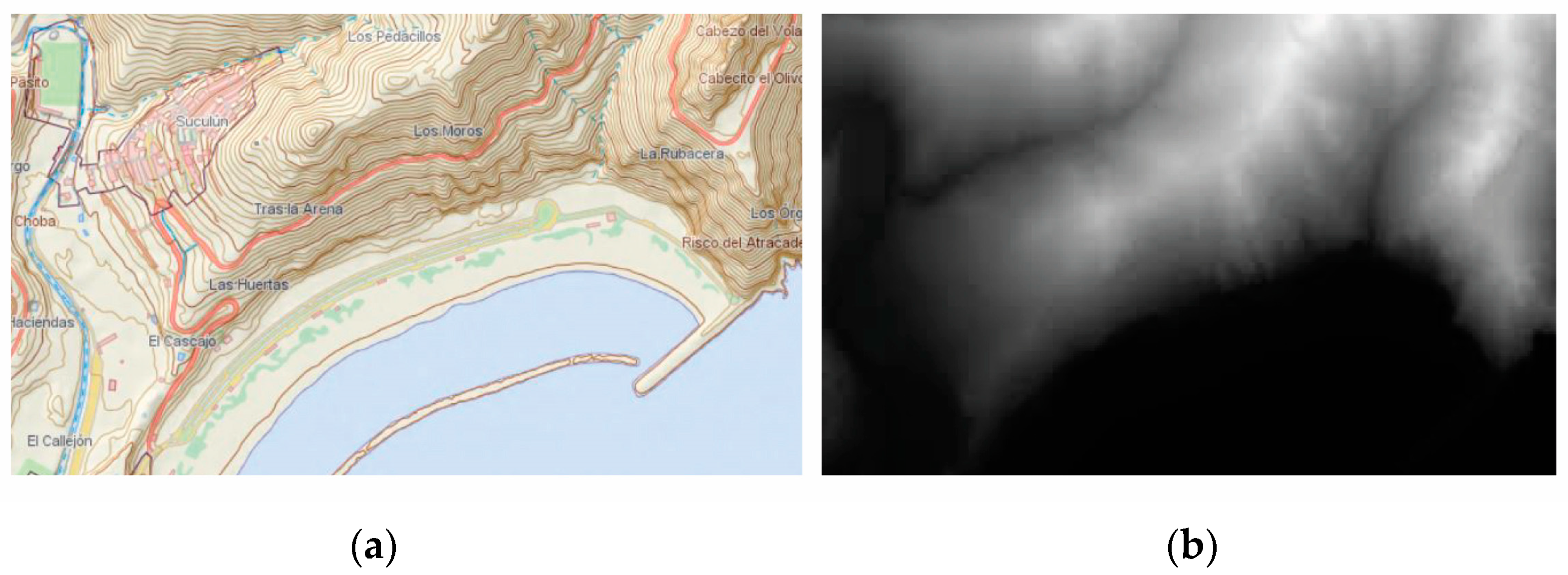
3.2. Geoportal of National Geographic Information Center

The landscape workshop was held at the University of La Laguna, in Tenerife, Spain; for this reason, the Geoportal of the National Geographic Information Center of Spain was used to obtain topographic information (height map). (http://centrodedescargas.cnig.es/CentroDescargas/locale?request_locale=en (accessed on 5 May 2021)). In this resource, height maps of the terrain with a 5-m mesh can be downloaded for further processing with Unity 3D. The geographic reference system is REGCAN95 (Canary Islands), compatible with WGS84.

3.3. Questionnaire on User eXperience in Immersive Virtual Environments

The tool to measure User eXperience in an Immersive Virtual Environment is the Questionnaire on User eXperience in Immersive Virtual Environments (QUXiVE). The User eXperience (UX) definition by the ISO 9241-210 norm is “The user’s perceptions and responses resulting from the use of a system or a service”. The Questionnaire on User eXperience in Immersive Virtual Environments is a standardized questionnaire validated by Tcha-Tokey et al. [10,28] that includes 10 components/subscales such as presence, engagement, immersion, flow, skill, emotion, usability, technology adoption, judgment and, finally, experience consequence. The Questionnaire on User eXperience in Immersive Virtual Environments is made up of a selection of items from different existing standardized tests that measure each of the ten items considered. The authors of this questionnaire indicate that it should be adapted to each research practice. For this research, we have worked with nine of the 10 subscales of the original Questionnaire on User eXperience in Immersive Virtual Environments (Table 1).
Therefore, our adapted Questionnaire on User eXperience in Immersive Virtual Environments is made up of 72 items on a 10-Likert-type Scale and also contains three open questions in which the user is asked about their experience in the virtual environment.

3.4. Intrinsic Motivation Inventory (IMI)

The Intrinsic Motivation Inventory (IMI) has been developed by the Rochester Motivation Research Group [30]. It is a tool for measuring the subjective experience of the user in relation to a specific target activity in laboratory experiments. The five subscales of the IMI considered in the present research are Interest/enjoyment, Perceived competence, Effort/importance, Pressure/tension, and Value/usefulness. It is composed of 15 items that cover the five subscales in a 7-point Likert-type scale (Table 2).

3.5. Methodology: The Landscape Workshop

The landscape workshop is a training activity included within the curriculum of the activities to be carried out in the Bachelor in Architecture degree, at La Laguna University.

3.5.1. Participants

A total of 25 second-year students of the Bachelor in Architecture degree of La Laguna University carried out the landscape workshop (gender: 10 female, 15 female; mean age: 20.64 with standard deviation (s.d.) of 1.69). Participants were asked if they had any previous experience with immersive technologies. None of the students had prior experience with these types of 3D viewing environments.

3.5.2. Procedure

At first, the workshop was planned with HDM-based (head-mounted displays) iVR devices. With the appearance of COVID-19, it was extremely difficult to carry out the workshop with HDM, since the virtual reality glasses had to be shared due to not having a sufficient number, with the consequent risk of contagion. Therefore, the workshop was conducted with low-immersion desktop environments (Figure 1a), in which each participant used their own personal computer.
The workshop was structured in three phases:
Phase 1: Instruction. 2 h. In this phase, participants were instructed in the use of Unity 3D, including its main functions for landscape design, as well as the operation of the FPS controller’s movement. Regarding landscape design with Unity 3D, participants were instructed on the basic options for terrain creation and editing. They received introductory training on the terrain options, as well as the use of standard assets and the Unity Asset Store to incorporate landscape design elements. In turn, the participants learned how to import cartographies using the settings of the terrain menu.
Unity 3D allows the creation of terrains through the “terrain” menu, with which the user can start from basic geometric shapes and raise or lower terrain, paint texture, set height, smooth height, and stamp terrain, among other options. However, in landscape design, it is common to work with a real terrain existing in a specific geographical environment that is cartographically represented. The Unity 3D terrain import menu allows the import of height maps. There are open source websites such as https://terrain.party/ (accessed on 5 May 2021) or https://tangrams.github.io/heightmapper/ (accessed on 5 May 2021) where these height maps can be downloaded in PNG format, although with low resolution. To solve this problem, we started from the download site of the Spanish National Geographic Information Center, where it is possible to download height maps with a better resolution (5-m mesh) with ASC extension. With the free web applications such as “Height map creator” or QGIS, we convert the ASC format of the height map to RAW format for import from Unity 3D.
In relation to the possibilities of movement in the environment, the FPS Controller’s movement possibilities are as follows: A key to go left, W key to move forward, D key to go right, S key to go back, and space bar to jump. Combining the shift key with any of the movement keys increases speed. With the mouse, the user can move the display up/down and left/right in order to obtain a 360° image of the environment.
Phase 2: Geovisualization tasks. 3 h. In order for all participants to work in the same geovisualization environment, the instructor previously created a virtual landscape environment, which is located in Las Teresitas beach, Tenerife, Spain, using Unity 3D. It is a coastal area with great relief and different landscape elements such as sand, water, dikes, and architectural components such as lifeguard houses. The height map of this area was imported from the Spanish National Geographic Information Center (Figure 2).
Once the terrain file of Las Teresitas beach has been imported in Unity 3D, through the “paint texture” editing option, the user can assign different textures to the terrain. Through the “Standard Assets” menu, the user has a variety of textures and elements typical of landscape design such as different types of vegetation, soils (sandy, rocky, etc.), trees, shrubs, etc. Should more items be needed, they can be obtained from the Asset Store. Using these Unity 3D editing options for the selected area, the instructor created a virtual landscape environment to be viewed by the students (Figure 2). To add a fun touch to the workshop and at the same time try to increase the feeling of immersion in the environment, a policeman has been introduced who chases the user at all times. This virtual landscape environment is free available at http://playa.joseluissaorin.com (accessed on 3 May 2021) (Figure 3).
Once inside the landscape environment, the students had to take a tour of specific points in it where they were consulted on characteristic elements of the landscape. For this objective, seven geovisualization tasks were proposed to the participants:
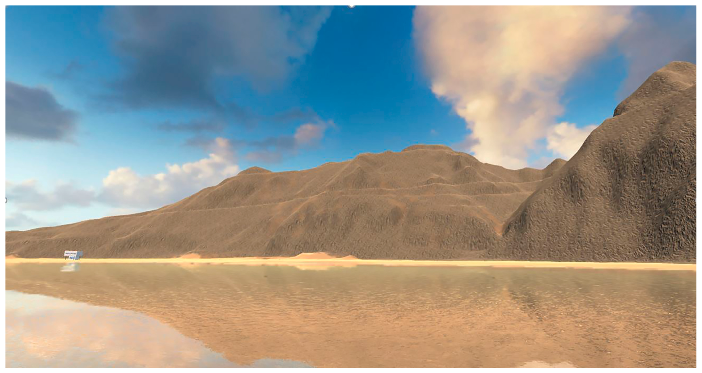
  • Geovisualization task 1: Move the character’s head and enjoy the 360° views of Las Teresitas Beach. Look for the policeman who is chasing you and try to move before he reaches your position.
  • Geovisualization task 2: Walk until you are at the end of the jetty and turn your body to look at the mountains. How many lifeguard houses can you see from there?
  • Geovisualization task 3: Walk toward the mountains and climb them until you reach the top (the space bar allows you to jump to climb the steepest slopes). On the way up, we can see areas of the land that are flat that correspond to the road that leads to Playa de Las Gaviotas. Once we go up to the top, go over the top of the mountains and turn your body to see the beach from above. Can you locate the policeman who is looking for you?
  • Geovisualization task 4: Go down the mountain and walk to one of the lifeguard houses on the beach. Enter the ground floor and look out the window towards the beach. Exit the booth, go up the stairs, and enter the first floor of the lifeguard house. What object is on the table? Look out the window again at the beach.
  • Geovisualization task 5: Walk to the edge of the beach and turn around, looking toward the lifeguard houses. Can they be seen reflected in the water? Can you see the effect of refraction? Are the mountains refracted in the water also appreciated?
  • Geovisualization task 6: Since you are on the shore of the beach, dive into the water a bit. The cop is chasing you. Does the policeman’s body submerge in the water as he moves toward you?
  • Geovisualization task 7: As a landscape designer, you have to project an intervention Las Teresitas beach: you can plant trees, cover slopes with different types of textures, plant hedges, install wastebaskets, paths for bathers, showers, etc., and all those landscape design elements of the environment that you consider. Take a walk through the new environment you have created and see the result from different points of view.
Phase 3: Questionnaires 1 h 30 min. Students responded to the Questionnaire on User eXperience in Immersive Virtual Environments [10,28] as well as the Intrinsic Motivation Inventory [30]. These questionnaires were answered within the virtual teaching environment (virtual classroom) of the second year of the architecture degree of the University of La Laguna.

4. Results

The results obtained in the Questionnaire on User eXperience in Immersive Virtual Environments [10,28] are presented as well as the effect that the workshop has had from the point of view of motivation on students, which was obtained through Intrinsic Motivation Inventory [30].

4.1. Results of the Questionnaire on User eXperience in Immersive Virtual Environments

The reliability of the Questionnaire on User eXperience in Immersive Virtual Environments has been verified with Cronbach’s alpha. The scale for the interpretation of Cronbach’s alpha values, according to George and Mallery [89] are: > 0.9 excellent; > 0.8 good; 0.7 acceptable; 0.6 questionable; and > 0.5 poor. The reliability of the result obtained in the present research is excellent (0.952) according with this scale.
The results of each of the nine subscales considered in the Questionnaire on User eXperience in Immersive Virtual Environments are displayed for each subscale.
Subscale Presence: “The user’s ‘sense of being there’ in the virtual environment”. The average value obtained in a 10-point Likert-type scale is 7.47 (SD = 1.45) (Table 3).
Subscale Engagement: “The energy in action, the connection between a person and its activity consisting of a behavioral, emotional, and cognitive form”. The average value obtained in this subscale is 7.47 (SD = 1.45), Table 4.
Subscale Immersion: “the illusion that the virtual environment technology replaces the user’s sensory stimuli by the virtual sensory stimuli” (Table 5).
Subscale Flow: “a pleasant psychological state of sense of control, fun and joy” that the user feels when interacting with the virtual environment (Table 6).
Subscale Usability: “The ease of learning (learnability and memorizing) and the ease of using (efficiency, effectiveness, and satisfaction) the virtual environment (Table 7).
Subscale Emotion: “The feelings (of joy, pleasure, satisfaction, frustration, disappointment, anxiety, etc.) of the user in the virtual environment” (Table 8).
Subscale Judgment: “The overall judgment of the experience in the virtual environment” (Table 9).
Subscale Experience Consequence: “The symptoms (e.g., the “simulator sickness”, stress, dizziness, headache, etc.) the user can experience in the virtual environment” (Table 10).
Subscale Technology Adoption: “The actions and decisions taken by the user for future use or intention to use the virtual environment” (Table 11).
The last questions of the Questionnaire on User eXperience in Immersive Virtual Environments are three open questions about the opinion of the students about their experience working in the virtual environment. Here are some of the answers:
Free Question 1: In your opinion, what were the positive points about your experience? “I found it to be a different, original and above all [a] very interactive activity”. “It was a different task from the ones we usually do, curious and with which many types of landscape design work can be done by adapting the virtual environment”. “To be able to visualize the environment 360° and walk it virtually”. “It is a good idea to carry out tasks and practices for the subject”. “The environment allowed observing different objects from very different points of view (coast–mountain)”.
Free Question 2: In your opinion, what were the negative points about your experience? “The virtual environment was a bit slow”. “The way up the mountain seemed somewhat false to me”. “Footstep sounds were smooth and hard, not beach/sand”. “It is a pity that it does not allow a view under the water”. “I suffered some kind of dizziness or anxiety while in the virtual environment”.
Free Question 3: Do you have suggestions to improve this virtual reality environment? “Improve the quality and sound in the virtual environment”. “Add more characters, more objects and a higher level of interaction with objects and the environment”. “Improve the synchronization of sound with movements.”

4.2. Results of the Intrinsic Motivation Inventory (IMI).

The reliability of the Intrinsic Motivation Inventory has been verified with Cronbach’s alpha. The value obtained on the reliability of the results obtained in this research is high: 0.88.
The results are shown for each of the five subscales considered. We recall that the Intrinsic Motivation Inventory questionnaire was posed on a 7-point Likert scale, unlike the previous one, the Questionnaire on User experience in Immersive Virtual Environments, which was posed on a 10-point Likert scale (Table 12).
The results obtained for all subscales are greater than 5 points, with the exception of the pressure/tension subscale, which has a value of 1.76. A low score on this subscale means that the student has not felt tension or anxiety doing the workshop, which is in favor of its motivating effect. In this case, according to IMI instructions, this score must be reversed, subtracting 8 from the answer. Therefore, for the purposes of global scoring in relation to the rest of the subscales, the average value of Pressure/Tension subscale will be 6.24 points.

5. Discussion

In the present research, twenty-five architect students have performed a workshop in which geovisualization and landscape design tasks were carried out in a realistic 3D-VR geovisualization of the terrain using Unity 3D game engine in a low-immersive desktop screen environment. The perception of the 3D environment during geovisualization has been measured as well as the impact that the workshop has had on the motivation of the students regarding this teaching–learning approach.

5.1. The Perception of the 3D Environment during Geovisualization

Presence. This subscale is also known as “Sense of Presence” [23]. Authors such as Jaalama et al. [23] affirmed that the sense of presence is a determining factor in evaluating the effectiveness of a 3D geovisualization. Findings in previous research on the sense of presence such as those carried out by Chang and Clear [74]; Chang, Hou, Bowser, Sung, and Pan [75]; and Bowser et al. [76] suggested that approaches based on virtual environments favor the sense of presence, learning motivation, and learning achievements among students. In the Questionnaire on User eXperience in Immersive Virtual Environments, the “presence” factor has 12 items. Of these 12 items, there are seven above the mean (7.47) and five below. Of those that are above the average, for example, the one corresponding to the response of the virtual environment to the user’s actions stands out (8.8, SD = 1.04). We also highlight the high perception of the environment in geovisualization tasks (8.6, SD = 1.29), the possibility of observing objects from multiple viewpoints (8.76, SD = 1.54), and the perception of being able to move and interact fluidly in the virtual environment. On the other hand, values below the mean also offer relevant information. Users appreciated with an average value of 6.84 (SD = 2.13) the naturalness with which they interacted (up, down, scroll) with the virtual environment, as well as the device used to control movement, in this case mouse and keyboard, with an average value of 6.88 (SD = 2.09). The subscale presence has been researched in virtual environments in order to examine the realism perceived by the user, the sensation of presence or the subjective perception of being in a certain place, caused by the sensation of immersion [70,71,82], although these researchers were focused on virtual reality environments with HDM displays. In this sense, it is to be expected that with HDM (head-mounted displays) devices, the perception of naturalness in movements will increase, as movements occur in a more natural way by moving and tilting the head. Therefore, it is necessary to conduct future research of this topic in the field of landscape design environments with HMD devices, although our findings on this topic with low-immersive environments show good results with an average value = 7.47, SD = 1.45.
The engagement subscale has three items. Users perceived with an average value of 6.96 (SD = 2.19) that the visual aspects of the virtual environment involved them. They also felt involved in the virtual environment experience (7.6, SD = 2.12). In this subscale, we highlight the item, “The sense of moving around inside the virtual environment was compelling”, for which the result has been 7.40, SD = 1.87. In landscape design teaching, when planning learning activities in virtual environments, it is interesting to create a convincing geovisualization environment that focuses the student’s attention on the task itself and not on the verisimilitude of what is represented.
The immersion subscale is made up of seven items. Authors such as Philips et al. [67] have already highlighted the need to research the impact of immersive 3D geovisualizations in higher education, as well as the benefits of immersive 3D geovisualization for research and research-based learning. Regarding the results obtained in this subscale, we highlight values such as feeling stimulated, and physically fit in the virtual environment (6.72, SD = 2.26 and 5.6, SD = 2.69 respectively). To the item, “I become so involved in the virtual environment that I was not aware of things happening around me”, participants responded with an average value of 5.4 (SD = 2.66). Another item that expresses the phenomenon of immersion is, “I become so involved in the virtual environment that I lose all track of time”, to which participants responded with an average value of 5.2 (SD = 2.75). The police presence did not scare them (4.12, SD = 2.79). It should be noted that the average values obtained in this subscale are between 6.72 (SD = 2.26) and 4.12 (SD = 2.79), which we find unsatisfactory. In the immersion subscale, the device used plays an important role, and with HDM (head-mounted displays), the immersion sensation would increase in what authors such as Halik [90] call a “fully immersive experience”. In the field of geovisualization, future research is needed on this topic using geovisualization immersive virtual environments (GeoIVE) [65].
The flow subscale constitutes “a pleasant psychological state of sense of control, fun and joy” that the user feels when interacting with the virtual environment. The flow subscale is made up of 11 items. The participants felt that they controlled the situation (8.44, SD = 1.39), that they were experiencing an exciting time (5.44, SD = 2.55), and that they felt that they could perfectly control their actions within the virtual environment (7.28, SD = 2.09). The perception that users had that time seemed to flow differently than usual is curious (6.28, SD = 2.48). Authors such as Williams [51] highlighted in previous research the importance of flow measurement in the field of Virtual Reality, proposing future research on this topic. In this sense, the present research provides relevant data on flow topic.
Usability. The participants considered that the interaction devices (in this case, the mouse and keyboard keys) were easy to use with an average value of 7.36 (SD = 2.53). In this sense, it is possible that the use of a joystick would have raised this value. In relation to interacting devices, future research is needed in the field of geovisualization using external tracking sensors to enable motion tracking in an iVR system with an HDM device. Regarding the usability subscale, within the Questionnaire on User eXperience in Immersive Virtual Environments, we understand that it would need more items to perform a more complete measurement of usability in terms of effectiveness, efficiency, and user satisfaction, following the recommendations for the evaluation of usability described in R3UEMs (Review, Report, and Refine Usability Evaluation Methods) [91]. Previous research has been carried out following the R3UEMs using iVR with HDD devices in urban virtual environments [92] and using Augmented Reality technology for landscape geovisualization [29].
The emotion subscale is made up of 15 items, and most of the results obtained are below 5. However, this value is due to the nature of some of the items—for example, if they felt tense in the virtual environment, they responded with an average value of 3.4 (SD = 2.66), or for example, the item about whether they felt nervous in the virtual environment (3.08, SD = 2.31). Obtaining low scores on these items reflects a good user response in the virtual environment. High values (6.8, SD = 2.68) such as those obtained in the item of whether the students enjoyed being in the virtual environment help to understand the feedback of the students regarding this subscale.
The judgment subscale measures “the overall judgment of the experience in the virtual environment”. In this subscale, the average value of 8.16 (SD = 0 1.70) stands out in the item, “Personally, I would say that the virtual environment is practical”, as well as the average value of 7.52 in the item “Personally, I would say the virtual environment is clear (not confusing)”. We find also values such as 6.04 in the item, “I found this virtual environment gaudy (1)/classy (10)” and 6.64 (SD = 2.29) in the item, “I found that this virtual environment is discouraging (1)/motivating (10)”. It is interesting to know that students value positively (with scores above 5.0) this 3D geovisualization environment in low-immersive desktop environments as a practical, clear, manageable, original, motivating, and even exciting learning environment. Although, on the other hand, they value it closer to the amateur field than to the professional one. In this regard, it would be necessary to research whether better results are obtained with virtual reality technology with HDM devices (head-mounted displays) and external tracking sensors to enable motion tracking.
Regarding the experience consequence subscale, previous research has already highlighted the need to measure the impact that VR technology has on user health [92]. In the educational field, factors such as motion sickness and the consequences of the use of VR for educational applications are also usually studied [9,13]. Fortunately, very low values (below 2.84) have been obtained for all the items on this subscale. For the items on whether they suffered fatigue, headache, eyestrain, increased sweating, nausea, dizziness with eyes open, or vertigo during the interaction with the virtual environment, the average values were, respectively: 2.44 (SD = 2.18), 2.00 (SD = 1.73), 2.2 (SD = 1.71), 1.52 (SD = 1.16), 1.72 (SD = 1.84), 1.64 (SD = 1.29), and finally, 1.8 (SD = 2.00). These values could presumably increase in a virtual environment with HDM (head-mounted display) devices. In the present research, a game engine has been used in a low-immersive desktop screen environment. In the field of video games, traditional low-immersive desktop-based games use a combination of mouse, key combinations, and/or joystick, causing milder simulator sickness effects than high iVR systems.
The technology adoption subscale is interesting, as it shows the appreciation that students have of this tool for future applications. This subscale is made up of nine items. Students considered that, “Learning to operate the virtual environment would be easy for me” (8.08, sd = 1.55), and “It would be easy for me to become skillful at using the virtual environment” (7.52, SD = 2.35). Regarding interaction devices, participants responded that, “The interaction devices (Oculus headset, gamepad, and/or keyboard) would make work more interesting” (8.04, SD = 1.95) and “I would like working with the interaction devices (Oculus headset, gamepad, and/or keyboard)” (7.88, SD = 2.22). In the present research, the students used a keyboard and mouse. It would be interesting to know the possibilities of devices such as HDM devices (head-mounted displays) and external tracking sensors for geovisualization.

5.2. The Effect in the Motivation of Students

In the educational field, the motivational factor for using VR for educational applications is usually studied [9,13]. In the present research, it has been analyzed considering five subscales.
Interest/Enjoyment Subscale. Items (1-3). This subscale considers the self-report measure of intrinsic motivation. It is only the one subscale that assesses intrinsic motivation, per se. The average value obtained in this subscale has been high (5.75, SD = 0.31). It is a very positive result since it indicates that the workshop, in addition to being fun (5.40, SD = 2.32), enjoyable (6.00, SD = 1.76), and interesting (5.84, SD = 2.93) has motivated the students.
Perceived Competence Subscale. Items (4-6). The perceived competence concepts are theorized to be positive predictors of both self-report and behavioral measures of intrinsic motivation. In this subscale, the average value obtained is also high (5.34, SD = 1.05). It gives us an idea about the perception that students have about having acquired competencies and skills related to the contents that have been worked on in the workshop. Participants feel that they were quite good at doing the workshop (5.56, SD = 1.37), and they were satisfied with their performance at the workshop (6.08, SD = 1.83). After working in the shop, they felt pretty competent (4.60, SD = 2.48).
Effort/Importance Subscale. Items (7-8). It measures both the effort in carrying out a certain activity due to its difficulty and the importance that the user gives to their participation in that activity. The average value was 5.40, SD = 0.91. In other words, they took their participation in the workshop seriously and made an effort to solve the tasks. The students struggled to work in the workshop (4.76, SD = 2.98). It was important for them to carry out the tasks of the workshop (6.04, SD = 0.99).
Pressure/Tension Subscale. Items (9-10). For this subscale, it is desirable to obtain a value as low as possible, which means that the student has not felt pressured or stressed doing the workshop. The average value obtained is low (1.76, SD = 0.28), which is positive regarding the students’ perception of the workshop. Accounting for its inverse value (6.24) turns out to be the best considered subscale.
Value/Usefulness Subscale. Items (11-15). This subscale analyzes whether the activities carried out have value and whether they are useful to the participants. The items on this subscale, in addition to providing data on the motivation of the workshop participants, provide valuable data on the student’s perception of aspects related to landscape design in virtual environments (see Table 12). The average value obtained in this subscale has been high (5.95, SD = 0.18).
The mean values obtained in the five motivation subscales analyzed are all above the 5.34 in a 7-point Likert-type scale. We have used a video game environment with game engine and virtual reality, which are technologies that separately have been shown to be motivating in educational contexts in previous research. On the one hand, these learning environments motivate students and involve them in the learning process [93,94]. On the other hand, immersive 3D geovisualization using VR has also been shown to be motivating both for students [29,67,92] and for the participative landscape planning [95].

6. Conclusions

A workshop using an interactive 3D geovisualization environment based on a low-immersive 2D desktop screen environment has carried out. The Unity 3D game engine has been used for the creation of the VR environment, in which students performed tasks related with geovisualization and landscape design. The perception of the 3D environment during geovisualization was analyzed through the Questionnaire on User eXperience in Immersive Virtual Environments (QUXiVE) [9,23], and the impact of this technology as a motivating element among students was also measured with the Intrinsic Motivation Inventory.
The sense of presence is considered such a determining factor in evaluating the effectiveness of a 3D geovisualization. Although our findings on this topic with low-immersive environments shows good results, it would be necessary to conduct future research on this topic in the field of landscape design environments with HMD (head-mounted displays) devices. In addition, these devices can increase the sensation of immersion, although on the other hand, they also increase dizziness and motion sickness. This is an important factor to consider both for the planning of teaching–learning strategies and for its use as a professional tool in landscape planning. In this sense, geovisualization environments based on a low-immersive 2D desktop screen environment, such as those used in the present research, have proven to be an interesting option to avoid this problem.
From the point of view of the usability of the low-immersive 2D desktop screen environment as a geovisualization tool, although the data obtained with the Questionnaire on User eXperience in Immersive Virtual Environments are positive, a more exhaustive study would be necessary.
The free responses of the participants about the landscape workshop were very interesting and positive. They positively value the originality of the teaching approach, within the framework of geovisualization activities in landscape design. Although it is necessary to improve factors such as interactive sound, and despite the fact that this type of environment can generate some dizziness or fatigue, the opinions of the participants invite us to think that we are on the right track.
The game engine-based teaching approach carried out has been motivating for students, which is in line with previous research. Motivation plays a fundamental role in teaching–learning processes, and especially in those in which the visualization of geospatial information is necessary.
Regarding the design elements and characteristics that allowed the positive perspective of using immersive VR, we highlight that the participants were able to use their own computers and their own mouse without the need to install any software. In addition, these types of teaching strategies based on 3D visualization continue to be novel for students.
An immersive 3D geovisualization environment using a game engine for landscape design teaching and research through low-immersive desktop screen environments is an alternative to iVR with HDM devices in situations such as COVID-19, in which device sharing (HDM) could mean risk of contagion. Regardless of the health emergency environment, the planning of teaching–learning or research strategies in which HDM is needed may be limited by the need to have these devices, which are not always available or not in sufficient number.
Future research:
In order to provide an intuitive 3D geovisualization and interaction scenario, which allows different stakeholders, with different backgrounds, experience, and training, to work together around a landscape design project, initiatives such as the aforementioned VirCa system could be useful. It would be interesting, as future research, to analyze the possibilities of this type of interactive and collaborative 3D visualization platforms in the field of landscape design.
For the interaction with the virtual environment, we have used the keyboard and the mouse, and the participants have positively valued these devices in their geovisualization tasks. In this sense, we think that iVR environments as HDM devices with external tracking sensors could offer great possibilities. It is necessary to study this topic in future research.
The present research focuses exclusively on the realistic 3D geovisualization of the geographic environment, that is, the 3D geographic representation and visualization of terrain using Virtual Reality. It would be interesting to analyze these geovisualization environments in which geographic data were also represented.
Limitations:
To carry out this research, we have had some limitations. The number of participants, although we understand enough, was low. It was research carried out in the middle of the COVID pandemic, with the consequent decrease in the number of students as the disease affected some. In turn, it would have been desirable for all students to carry out the workshop with the same computers, monitors, and mouse, although we understand that this factor should not be decisive. Another limitation has been not being able to use HDM devices with external tracking sensors due to the risks of contagion, since it would have been necessary to share the devices among the participants. A future workshop with these devices could provide comparative data that would help landscape design teachers to adopt one or another technology in their teaching planning, depending on the task to be carried out.

Author Contributions

Conceptualization, C.C.-C., D.M.D. and J.L.S.; methodology, C.C.-C. and J.L.S.; software, D.M.D. and J.L.S.; validation, C.C.-C., D.M.D. and J.L.S.; formal analysis, C.C.-C.; Investigation, C.C.-C.; resources, D.M.D. and J.L.S.; data curation, C.C.-C. and J.L.S.; writing—original draft preparation, C.C.-C.; writing—review and editing, C.C.-C., D.M.D. and J.L.S.; visualization, D.M.D. and J.L.S.; supervision, C.C.-C., D.M.D. and J.L.S.; project administration, C.C.-C., D.M.D. and J.L.S.; All authors have read and agreed to the published version of the manuscript.

Funding

The University of La Laguna has partially supported this work: Innovate Educational Project for the academic year 2020/2021 “Geospatial Thinking Predictive Analysis”.

Conflicts of Interest

The authors declare no conflict of interest.

References

  1. Kent, A. Topographic Maps: Methodological Approaches for Analyzing Cartographic Style. J. Map Geogr. Libr. 2009, 5, 131–156. [Google Scholar] [CrossRef]
  2. Hopfstock, A. A Common Design for Topographic Maps in Europe? In Proceedings of the XXII International Cartographic Conference, La Coruña, Spain, 11–16 July 2005. [Google Scholar]
  3. Smith, M.J.; Hillier, J.K.; Otto, J.-C.; Geilhausen, M. Geovisualization. In Treatise on Geomorphology Remote Sensing and GIScience in Geomorphology; Shroder, J., Bishop, M.P., Eds.; Academic Press: San Diego, CA, USA, 2013; Volume 3, pp. 299–325. [Google Scholar]
  4. Punia, M.; Kundu, A. Three dimensional modelling and rural landscape geo-visualization using geo-spatial science and technology. Neo Geogr. 2014, 3, 1–19. [Google Scholar]
  5. Koua, E.L.; MacEachren, A.; Kraak, M.-J. Evaluating the usability of visualization methods in an exploratory geovisualization environment. Int. J. Geogr. Inf. Sci. 2006, 20, 425–448. [Google Scholar] [CrossRef]
  6. Golebiowska, I.; Opach, T.; Rød, J.K. Breaking the Eyes: How Do Users Get Started with a Coordinated and Multiple View Geovisualization Tool? Cartogr. J. 2020, 57, 235–248. [Google Scholar] [CrossRef] [Green Version]
  7. Bailenson, J.N.; Yee, N.; Blascovich, J.; Beall, A.C.; Lundblad, N.; Jin, M. The Use of Dimmersive Virtual Reality in the Learning Sciences: Digital Transformations of Teachers, Students, and Social Context. J. Learn. Sci. 2008, 17, 102–141. [Google Scholar] [CrossRef] [Green Version]
  8. Bowman, D.A.; Sowndararajan, A.; Ragan, E.D.; Kopper, R. Higher levels of immersion improve procedure memorization performance. Presented at the Joint Virtual Reality Conference of EGVE–ICAT–EuroVR, Lyon, France, 7–9 December 2009. [Google Scholar]
  9. Jia, D.; Bhatti, A.; Nahavandi, S. The impact of self-efficacy and perceived system efficacy on effectiveness of virtual training systems. Behav. Inf. Technol. 2012, 33, 16–35. [Google Scholar] [CrossRef]
  10. Tcha-Tokey, K.; Loup-Escande, E.; Christmann, O.; Richir, S. A questionnaire to measure the user experience in immersive virtual environments. In Proceedings of the 2016 Virtual Reality International Conference, Laval, France, 1–5 March 2016. [Google Scholar]
  11. Dede, C. Immersive Interfaces for Engagement and Learning. Science 2009, 323, 66–69. [Google Scholar] [CrossRef] [PubMed] [Green Version]
  12. Mikropoulos, T.A.; Natsis, A. Educational virtual environments: A ten-year review of empirical research (1999–2009). Comput. Educ. 2011, 56, 769–780. [Google Scholar] [CrossRef]
  13. Webster, R. Declarative knowledge acquisition in immersive virtual learning environments. Interact. Learn. Environ. 2014, 24, 1319–1333. [Google Scholar] [CrossRef]
  14. Lee, E.A.-L.; Wong, K.W. A Review of Using Virtual Reality for Learning. In Transactions on Edutainment I; Springer: Berlin, Germany, 2008; pp. 231–241. [Google Scholar]
  15. Mikropoulos, T.A. Presence: A unique characteristic in educational virtual environments. Virtual Real. 2006, 10, 197–206. [Google Scholar] [CrossRef]
  16. Ragan, E.D.; Bowman, D.A.; Huber, K. Supporting cognitive processing with spatial information presentations in virtual environments. Virtual Real. 2012, 16, 301–314. [Google Scholar] [CrossRef]
  17. Roussou, M.; Oliver, M.; Slater, M. The virtual playground: An educational virtual reality environment for evaluating inter-activity and conceptual learning. Virtual Real. 2006, 10, 227–240. [Google Scholar] [CrossRef]
  18. Balla, D.; Zichar, M.; Tóth, R.; Kiss, E.; Karancsi, G.; Mester, T. Geovisualization Techniques of Spatial Environmental Data Using Different Visualization Tools. Appl. Sci. 2020, 10, 6701. [Google Scholar] [CrossRef]
  19. Bishop, I.D. Landscape planning is not a game: Should it be? Landsc. Urban Plan. 2011, 100, 390–392. [Google Scholar] [CrossRef]
  20. Newell, R.; Canessa, R.; Sharma, T. Visualizing Our Options for Coastal Places: Exploring Realistic Immersive Geovisualizations as Tools for Inclusive Approaches to Coastal Planning and Management. Front. Mar. Sci. 2017, 4, 290. [Google Scholar] [CrossRef]
  21. Sheppard, S.R. Guidance for crystal ball gazers: Developing a code of ethics for landscape visualization. Landsc. Urban Plan. 2001, 54, 183–199. [Google Scholar] [CrossRef]
  22. Newell, R.; Canessa, R. Seeing, believing, and feeling: The relationship between sense of place and geovisualization research. Spaces Flows 2015, 6, 15–30. [Google Scholar] [CrossRef]
  23. Jaalama, K.; Fagerholm, N.; Julin, A.; Virtanen, J.-P.; Maksimainen, M.; Hyyppä, H. Sense of presence and sense of place in perceiving a 3D geovisualization for communication in urban planning–Differences introduced by prior familiarity with the place. Landsc. Urban Plan. 2021, 207, 103996. [Google Scholar] [CrossRef]
  24. Galambos, P.; Csapó, Á.; Zentay, P.; Fülöp, I.M.; Haidegger, T.; Baranyi, P.; Rudas, I.J. Design, programming and orchestra-tion of heterogeneous manufacturing systems through VR-powered remote collaboration. Robot. Comput. Integr. Manuf. 2015, 33, 68–77. [Google Scholar] [CrossRef]
  25. Galambos, P.; Weidig, C.; Zentay, P.; Csapó, A.; Baranyi, P.; Aurich, J.C.; Hamann, B.; Kreylos, O. VirCA NET: A collabora-tive use case scenario on factory layout planning. Communication 2012, 9, 67–83. [Google Scholar]
  26. Galambos, P.; Baranyi, P. VirCA as Virtual Intelligent Space for RT-Middleware. In Proceedings of the 2011 IEEE/ASME International Conference on Advanced Intelligent Mechatronics (AIM), Budapest, Hungary, 4–6 July 2011; IEEE: New York, NY, USA, 2011; pp. 140–145. [Google Scholar]
  27. Baranyi, P.; Csapo, A.; Sallai, G. Cognitive Infocommunications (CogInfoCom); Springer: Berlin, Germany, 2015; pp. 52–78. [Google Scholar]
  28. Tcha-Tokey, K.; Christmann, O.; Loup-Escande, E.; Richir, S. Proposition and Validation of a Questionnaire to Measure the User Experience in Immersive Virtual Environments. Int. J. Virtual Real. 2016, 16, 33–48. [Google Scholar] [CrossRef]
  29. Keller, J.M.; Litchfield, B.C. Motivation and Performance; Reiser, R.A., Dempsey, J.V., Eds.; Merrill Prentice Hall: Hoboken, NJ, USA, 2002. [Google Scholar]
  30. Ryan, R.M.; Deci, E.L. Self-determination theory and the facilitation of intrinsic motivation, social development, and well being. Am. Psychol. 2000, 55, 68–78. [Google Scholar] [CrossRef] [PubMed]
  31. Sheppard, S.R.; Shaw, A.; Flanders, D.; Burch, S.; Wiek, A.; Carmichael, J.; Robinson, J.; Cohen, S. Future visioning of local climate change: A framework for community engagement and planning with scenarios and visualisation. Futures 2011, 43, 400–412. [Google Scholar] [CrossRef]
  32. Bishop, I.D.; Pettit, C.J.; Sheth, F.; Sharma, S. Evaluation of Data Visualization Options for Land-Use Policy and Decision Making in Response to Climate Change. Environ. Plan. B Plan. Des. 2013, 40, 213–233. [Google Scholar] [CrossRef]
  33. Herbert, G.; Chen, X. A comparison of usefulness of 2D and 3D representations of urban planning. Cartogr. Geogr. Inf. Sci. 2014, 42, 22–32. [Google Scholar] [CrossRef]
  34. Billger, M.; Thuvander, L.; Wästberg, B.S. In search of visualization challenges: The development and implementation of visualization tools for supporting dialogue in urban planning processes. Environ. Plan. B Urban Anal. City Sci. 2016, 44, 1012–1035. [Google Scholar] [CrossRef]
  35. McCormick, B.H.; DeFanti, T.A.; Brown, M.D. Visualization in Scientific Computing. Comput. Graph. 1987, 10, 15–21. [Google Scholar] [CrossRef]
  36. Card, S.K.; Mackinlay, J.D.; Shneiderman, B. Readings in Information Visualization: Using Vision to Think. Morgan Kaufmann; Academic Press: San Francisco, CA, USA, 1999. [Google Scholar]
  37. Jiang, B.; Li, Z. Geovisualization: Design, Enhanced Visual Tools and Applications. Cartogr. J. 2005, 42, 3–4. [Google Scholar] [CrossRef] [Green Version]
  38. Bishop, I.D.; Lange, E. Visualization in Landscape and Environmental Planning. Technology and Applications; Taylor & Francis: Abingdon, UK, 2005; p. 296. [Google Scholar]
  39. Herwig, A.; Paar, P. Game engines: Tools for landscape visualization and planning. Trends GIS Virtualiz. Environ. Plan. Des. 2002, 161, 172. [Google Scholar]
  40. Lange, E. Digital representation of landscape change in Central Switzerland. Proc. Resour. Technol. 1994, 94, 26–30. [Google Scholar]
  41. Lange, E.; Schroth, O.; Wissen, U.; Schmid, W.A. Anforderungen an Visualisierungstools zur Partizipation der Öffentlichkeit bei der Bewertung der Landschaftsentwicklung; CORP: Wien, Austria, 2003. [Google Scholar]
  42. Lovett, A.; Kennaway, R.; Sünnenberg, G.; Cobb, D.; Dolman, P.; O‘Riordan, T. Visualizing sustainable agricultural landscapes. In Virtual Reality in Geography; Unwin, D., Fisher, P., Eds.; Routledge: London, UK, 2001; pp. 102–130. [Google Scholar]
  43. Orland, B. Visualization techniques for incorporation in forest planning geographic information systems. Landsc. Urban Plan. 1994, 30, 83–97. [Google Scholar] [CrossRef]
  44. Orland, B.; Budthimedhee, K.; Uusitalo, J. Considering virtual worlds as representations of landscape realities and as tools for landscape planning. Landsc. Urban Plan. 2001, 54, 139–148. [Google Scholar] [CrossRef]
  45. Snyder, K. Tools for Community Design and Decision-making. In Planning Support Systems in Practice; Geertman, S., Stillwell, J., Eds.; Springer: Heidelberg, Germany, 2003; pp. 99–120. [Google Scholar]
  46. Dockerty, T.; Lovett, A.; Sünnenberg, G.; Appleton, K.; Parry, M. Visualising the potential impacts of climate change on rural landscapes. Comput. Environ. Urban Syst. 2005, 29, 297–320. [Google Scholar] [CrossRef]
  47. Paar, P.; Clasen, M. Earth, Landscape, Biotope, Plant. Interactive Visualisation with Biosphere3D; CORP: Wien, Austria, 2007. [Google Scholar]
  48. Lange, E.; Hehl-Lange, S.; Brewer, M.J. Scenario-visualization for the assessment of perceived green space qualities at the urban–rural fringe. J. Environ. Manag. 2008, 89, 245–256. [Google Scholar] [CrossRef] [PubMed]
  49. Mól, A.C.A.; Jorge, C.A.F.; Couto, P.M. Using a Game Engine for VR Simulations in Evacuation Planning. IEEE Eng. Med. Boil. Mag. 2008, 28, 6–12. [Google Scholar]
  50. Ervin, S.M. Digital landscape modeling and visualization: A research agenda. Landsc. Urban Plan. 2001, 54, 49–62. [Google Scholar] [CrossRef]
  51. Williams, K.D. The effects of dissociation, game controllers, and 3D versus 2D on presence and enjoyment. Comput. Hum. Behav. 2014, 38, 142–150. [Google Scholar] [CrossRef]
  52. Laksono, D.; Aditya, T. Utilizing A Game Engine for Interactive 3D Topographic Data Visualization. ISPRS Int. J. Geo-Inf. 2019, 8, 361. [Google Scholar] [CrossRef] [Green Version]
  53. Indraprastha, A.; Shinozaki, M. The Investigation on Using Unity3D Game Engine in Urban Design Study. ITB J. Inf. Commun. Technol. 2009, 3, 1–18. [Google Scholar] [CrossRef] [Green Version]
  54. Tsai, Y.T.; Jhu, W.Y.; Chen, C.C.; Kao, C.H.; Chen, C.Y. Unity game engine: Interactive software design using digital glove for virtual reality baseball pitch training. Microsyst. Technol. 2019, 9, 1–17. [Google Scholar] [CrossRef]
  55. Alatalo, T.; Pouke, M.; Koskela, T.; Hurskainen, T.; Florea, C.; Ojala, T. Two real-world case studies on 3D web applications for participatory urban planning. In Proceedings of the 22nd International Conference on 3DWeb Technology, Brisbane, Australia, 5–7 June 2017. [Google Scholar]
  56. Lee, W.-L.; Tsai, M.-H.; Yang, C.-H.; Juang, J.-R.; Su, J.-Y. V3DM+: BIM interactive collaboration system for facility management. Vis. Eng. 2016, 4, 5. [Google Scholar] [CrossRef] [Green Version]
  57. Dutton, C. Correctly and accurately combining normal maps in 3D engines. Comput. Games J. 2013, 2, 41–54. [Google Scholar] [CrossRef]
  58. Shiratuddin, M.F.; Thabet, W. Utilizing a 3D game engine to develop a virtual design review system. Electron. J. Inf. Technol. Constr. 2011, 16, 39–68. [Google Scholar]
  59. Sharma, S.; Pettit, C.; Bishop, I.; Chan, P.; Sheth, F. An online landscape object library to support interactive landscape plan-ning. Future Internet. 2011, 3, 319–343. [Google Scholar] [CrossRef]
  60. Shin, I.-S.; Beirami, M.; Cho, S.-J.; Yu, Y.-H. Development of 3D Terrain Visualization for Navigation Simulation using a Unity 3D Development Tool. J. Korean Soc. Mar. Eng. 2015, 39, 570–576. [Google Scholar] [CrossRef]
  61. Navarro, A.; Pradilla, J.V.; Rios, O. Open Source 3D Game Engines for Serious Games Modeling. Model. Simul. Eng. 2012, 82, 143–158. [Google Scholar]
  62. Freina, L.; Ott, M. A literature review on immersive virtual reality in education: State of the art and perspectives. In eLearning and Software for Education (eLSE); Else: Bucharest, Romania, 2015. [Google Scholar]
  63. Shin, D.-H. The role of affordance in the experience of virtual reality learning: Technological and affective affordances in virtual reality. Telemat. Inform. 2017, 34, 1826–1836. [Google Scholar] [CrossRef]
  64. Zhao, J.; Sensibaugh, T.; Bodenheimer, B.; McNamara, T.P.; Nazareth, A.; Newcombe, N.; Klippel, A. Desktop versus im-mersive virtual environments: Effects on spatial learning. Spat. Cogn. Comput. 2020, 20, 328–363. [Google Scholar] [CrossRef]
  65. Hruby, F.; Ressl, R.; de la Borbolla Del Valle, G. Geovisualization with immersive virtual environments in theory and prac-tice. Int. J. Digit. Earth 2019, 12, 123–136. [Google Scholar] [CrossRef] [Green Version]
  66. Klippel, A.; Zhao, J.; Oprean, D.; Wallgrün, J.O.; Stubbs, C.; La Femina, P.; Jackson, K.L. The value of being there: Toward a science of immersive virtual field trips. Virtual Real. 2019, 24, 1–18. [Google Scholar] [CrossRef]
  67. Philips, A.; Walz, A.; Bergner, A.; Graeff, T.; Heistermann, M.; Kienzler, S.; Zeilinger, G. Immersive 3D geovisualization in higher education. J. Geogr. High. Educ. 2015, 39, 437–449. [Google Scholar] [CrossRef]
  68. Dykes, J.A.; MacEachren, A.M.; Kraak, M.-J. Exploring Geovisualization; Elsevier Ltd.: Amsterdam, The Netherlands, 2005. [Google Scholar]
  69. Kraak, M.-J. Geovisualization illustrated. ISPRS J. Photogramm. Remote. Sens. 2003, 57, 390–399. [Google Scholar] [CrossRef]
  70. Slater, M. Measuring Presence: A Response to the Witmer and Singer Presence Questionnaire. Presence 1999, 8, 560–565. [Google Scholar] [CrossRef]
  71. Lessiter, J.; Freeman, J.; Keogh, E.; Davidoff, J.B. A Cross-Media Presence Questionnaire: The ITC-Sense of Presence Inventory. Presence Teleoperators Virtual Environ. 2001, 10, 282–297. [Google Scholar] [CrossRef] [Green Version]
  72. Cummings, J.J.; Bailenson, J.N. How Immersive Is Enough? A Meta-Analysis of the Effect of Immersive Technology on User Immersive 3D geovisualization in higher education presence. Media Psychol. 2016, 19, 272–309. [Google Scholar] [CrossRef]
  73. Lindquist, M.; Lange, E.; Kang, J. From 3D landscape visualization to environmental simulation: The contribution of sound to the perception of virtual environments. Landsc. Urban Plan. 2016, 148, 216–231. [Google Scholar] [CrossRef] [Green Version]
  74. Chang, D.; Clear, T. Shaping behaviours through space and place in gamified virtual learning environments. In Gamification in Education and Business; Reiners, T., Wood, L.C., Eds.; Springer: Cham, Switzerland, 2015; pp. 331–354. [Google Scholar]
  75. Bowser, Y.L.; Hou, H.T.; Pan, C.Y.; Sung, Y.T.; Chang, K.E. Apply an augmented reality in a mobile guidance to increase sense of place for heritage places. J. Educ. Technol. Soc. 2015, 18, 166–178. [Google Scholar]
  76. Bowser, A.; Hansen, D.; He, Y.; Boston, C.; Reid, M.; Gunnell, L.; Preece, J. Using gamification to inspire new citizen science volunteers. In Proceedings of the First International Conference on Gameful Design, Research, and Applications, Toronto, ON, Canada, 2–4 October 2013; pp. 18–25. [Google Scholar]
  77. Cheok, Z.P.A.D.; Chang, W.M.M.; Zhang, M. Transactions on Edutainment VIII; Springer: Berlin, Germany, 2012. [Google Scholar]
  78. Shi, J.; Xiang, X.; Cheng, L. Status Quo and Countermeasure of Higher Education Informatization in Zhejiang Province. China Educ. Technol. 2010, 4, 32–35. [Google Scholar]
  79. Petridis, P.; Dunwell, I.; Panzoli, D.; Arnab, S.; Protopsaltis, A.; Hendrix, M.; Freitas, S.; De Freitas, S. Game Engines Selection Framework for High-Fidelity Serious Applications. Int. J. Interact. Worlds 2012, 2012, 1–19. [Google Scholar] [CrossRef]
  80. Carbonell-Carrera, C.; Gunalp, P.; Saorin, J.L.; Hess-Medler, S. Think Spatially With Game Engine. ISPRS Int. J. Geo-Inf. 2020, 9, 159. [Google Scholar] [CrossRef] [Green Version]
  81. Johnson, L.; Adams Becker, S.; Estrada, V.; Freeman, A. NMC Horizon Report: 2014; The New Media Consortium: Austin, TX, USA, 2014. [Google Scholar]
  82. Witmer, B.G.; Singer, M.J. Measuring Presence in Virtual Environments: A Presence Questionnaire. Presence Teleoperators Virtual Environ. 1998, 7, 225–240. [Google Scholar] [CrossRef]
  83. Heutte, J. La Part Du Collectif Dans La Motivation Et Son Impact Sur Le Bien-Être Comme Médiateur De La Réussite Des Étudiants: Complémentarités Et Contributions Entre L’autodétermination, L’auto-Efficacité Et L’autotélisme. Ph.D. Thesis, Univer-sité de Nanterre-Paris X, Nanterre, France, 2011. [Google Scholar]
  84. Pekrun, R.; Goetz, T.; Frenzel, A.C.; Barchfeld, P.; Perry, R.P. Measuring emotions in students’ learning and performance: The Achievement Emotions Questionnaire (AEQ). Contemp. Educ. Psychol. 2011, 36, 36–48. [Google Scholar] [CrossRef] [Green Version]
  85. Brooke, J. SUS: A ’Quick and Dirty’ Usability Scale. Usability Eval. Ind. 1996, 189, 4–7. [Google Scholar]
  86. Venkatesh, V.; Morris, M.G.; Davis, G.B.; Davis, F.D. User acceptance of information technology: Toward a unified view. MIS Q. 2003, 27, 425–478. [Google Scholar] [CrossRef] [Green Version]
  87. Hassenzahl, M.; Burmester, M.; Koller, F. Attrak Diff: Ein Fragebogen zur Messung Wahrgenommener Hedonischer und Pragmatischer Qualität [AttracDiff: A Questionnaire to Measure Perceived Hedonic and Pragmatic Quality]. In Mensch & Computer 2003. Interaktion in Bewegung; Ziegler, J., Szwillus, G., Eds.; Springer: Berlin, Germany, 2003; pp. 187–196. [Google Scholar]
  88. Kennedy, R.S.; Lane, N.E.; Berbaum, K.S.; Lilienthal, M.G. Simulator sickness questionnaire: An enhanced method for quan-tifying simulator sickness. Int. J. Aviat. Psychol. 1993, 3, 203–220. [Google Scholar] [CrossRef]
  89. George, D.; Mallery, M. SPSS for Windows Step by Step: A Simple Guide and Reference; Allyn & Bacon: Boston, MA, USA, 2003. [Google Scholar]
  90. Halik, Ł. Challenges in Converting the Polish Topographic Database of Built-Up Areas into 3D Virtual Reality Geovisualization. Cartogr. J. 2018, 55, 391–399. [Google Scholar] [CrossRef]
  91. Christou, G. Review of CPM-GOMS. In R3UEMs: Review, report and refine usability evaluation methods. In Proceedings of the 3rd International Workshop of COST294-MAUSE, Athens, Greece, 5 March 2007; pp. 20–54. [Google Scholar]
  92. Carbonell-Carrera, C.; Saorín, J.L. Geospatial Google Street View with Virtual Reality: A Motivational Approach for Spatial Training Education. ISPRS Int. J. Geo-Inf. 2017, 6, 261. [Google Scholar] [CrossRef] [Green Version]
  93. Zhang, N.; Zhu, J. The Discussion of Mobile Information Construction in University. Comput. Knowl. Technol. 2009, 5, 7263–7265. [Google Scholar]
  94. Meier, C.; Saorín, J.L.; De León, A.B.; Cobos, A.G. Using the Roblox Video Game Engine for Creating Virtual tours and Learning about the Sculptural Heritage. Int. J. Emerg. Technol. Learn. (iJET) 2020, 15, 268–280. [Google Scholar] [CrossRef]
  95. Wissen Hayek, U.; Greˆt-Regamey, A. Virtuelle landschaften zur partizipativen Planung der Landschaftsentwicklung–Einsatz und Nutzen von 3D Landschaftsvisualisierungen in Planungsworkshops [Virtual landscapes for participative plan-ning of landscape development–Application and value of 3D landscape visualisations in planning workshops]. In Forum fur Wissen 2010: Landschaftsqualita t. Konzepte, Indikatoren und Daten-Grundlagen; Eidgenossische Forschungsanstalt WSL: Birmensdorf, Switzerland, 2010. [Google Scholar]
Figure 1. Low-immersive desktop environment (a) and iVR with HDM devices (b). Adapted from [64] and [66].
Land 10 00492 g001
Figure 2. Original contour lines map of Las Teresitas beach (a) and height map (b).
Land 10 00492 g002
Figure 3. Las Teresitas Beach Landscape environment created with Unity 3D. http://playa.joseluissaorin.com, accessed on 3 May 2021.
Land 10 00492 g003
Table 1. Items of the Questionnaire on User eXperience in Immersive Virtual Environments considered in the present research.
SubscaleIs Defined as…Origin Questionnaire
Presence“The user’s ‘sense of being there’ in the virtual environment”The Presence Questionnaire [82]
The Immersive Tendency Questionnaire (ITQ)
[82]
Engagement“The energy in action, the connection between a person and its activity consisting of a behavioral, emotional and cognitive form”
ImmersionThe “illusion” that “the virtual environment technology replaces the user’s sensory stimuli by the virtual sensory stimuli”
Flow“A pleasant psychological state of sense of control, fun and joy” that the user feels when interacting with the virtual environment.Flow 4D16 [83]
Emotion“The feelings (of joy, pleasure, satisfaction, frustration, disappointment, anxiety, etc.) of the user in the virtual environment”Achievement Emotions Questionnaire (AEQ)
[84]
Usability“The ease of learning (learnability and memorizing) and the ease of using (efficiency, effectiveness and satisfaction) the virtual environment”System Usability Scale (SUS) [85]
Technology adoption“The actions and decisions taken by the user for a future use or intention to use the virtual environment”Unified Technology Acceptance and Use of Technology (UTAUT) [86]
Judgment“The overall judgment of the experience in the virtual environment”AttracDiff 2 questionnaire
[87]
Experience consequence“The symptoms (e.g., the “simulator sickness”, stress, dizziness, headache, etc.) the user can experience in the virtual environment”Simulator Sickness Questionnaire (SSQ) [88]
Table 2. Intrinsic motivation inventory subscales [25].
Intrinsic Motivation Inventory
Interest/enjoyment“Is considered the self-report measure of intrinsic motivation. It is the only subscale that assesses intrinsic motivation, per se”
Perceived competence“The perceived competence concepts are theorized to be positive predictors of both self-report and behavioral measures of intrinsic motivation”
Effort/importance“It measures both the effort in carrying out a certain activity due to its difficulty and the importance that the user gives to their participation in that activity”
Pressure/tension “Anxiety level during the activity. Pressure/tension is theorized to be a negative predictor of intrinsic motivation”
Value/usefulness“This subscale analyzes whether the activities carried out have value, whether they are useful to the participants”
Table 3. Questionnaire on User eXperience in Immersive Virtual Environments: Presence subscale.
Questionnaire on User eXperience in Immersive Virtual Environments: Presence Subscale
ItemScore (1–10) (s.d.)
1. “The virtual environment was responsive to actions that I initiated”8.80 (1.26)
2. “My interactions with the virtual environment seemed natural”6.84 (2.13)
3. “The devices (gamepad or keyboard), which controlled my movement in the virtual environment, seemed natural”6.88 (2.09)
4. “I was able to actively survey the virtual environment using vision”8.60 (1.29)
5. “I was able to examine objects closely”8.44 (1.66)
6. “I could examine objects from multiple viewpoints”8.76 (1.54)
7. “I felt proficient in moving and interacting with the virtual environment at the end of the experience”8.72 (1.10)
8 “The visual display quality distracted me from performing assigned tasks”4.76 (2.91)
9. “The devices (gamepad or keyboard), which controlled my movement, distract me from performing assigned tasks”4.72 (2.48)
10. “I could concentrate on the assigned tasks rather than on the devices (gamepad or keyboard)”8.08 (1.87)
11. “I correctly identified sounds produced by the virtual environment”7.64 (2.34)
12. “I correctly localized sounds produced by the virtual environment”7.40 (2.53)
Table 4. Questionnaire on User eXperience in Immersive Virtual Environments: Engagement subscale.
Questionnaire on User eXperience in Immersive Virtual Environments: Engagement Subscale
ItemScore (1–10) (s.d.)
1. “The visual aspects of the virtual environment involved me”6.96 (2.19)
2. “The sense of moving around inside the virtual environment was compelling”7.40 (1.87)
3. “I was involved in the virtual environment experience” 7.60 (2.12)
Table 5. Questionnaire on User eXperience in Immersive Virtual Environments: Immersion subscale.
Questionnaire on User eXperience in Immersive Virtual Environments: Immersion Subscale
ItemScore (1–10) (s.d.)
1. “I felt stimulated by the virtual environment”6.72 (2.26)
2. “I become so involved in the virtual environment that I was not aware of things happening around me”5.40 (2.66)
3. “I identified to the character I played in the virtual environment”6.04 (2.86)
4. “I become so involved in the virtual environment that it is if I was inside the game rather than manipulating a gamepad and watching a screen”5.56 (2.72)
5. “I felt physically fit in the virtual environment”5.60 (2.69)
6. “I got scared by something happening in the virtual environment”4.12 (2.79)
7. “I become so involved in the virtual environment that I lose all track of time”5.20 (2.75)
Table 6. Questionnaire on User eXperience in Immersive Virtual Environments: Flow subscale.
Questionnaire on User eXperience in Immersive Virtual Environments: Flow Subscale
ItemScore (1–10) (s.d.)
1. “I felt I could perfectly control my actions”8.80 (1.26)
2. “At each step, I knew what to do”6.84 (2.13)
3. “I felt I controlled the situation”6.88 (2.09)
4. “Time seemed to flow differently than usual”8.60 (1.29)
5. “Time seemed to speed up”8.44 (1.66)
6. “I was losing the sense of time”8.76 (1.54)
7. “I was not worried about other people’s judgment”8.72 (1.10)
8 “I was not worried about what other people’s judgment”4.76 (2.91)
9. “I was not worried about what other people would think of me”4.72 (2.48)
10. “I felt I was experiencing an exciting moment”8.08 (1.87)
11. “This experience was giving me a great sense of well-being”7.64 (2.34)
12. “When I mention the experience in the virtual environment, I feel emotions I would like to share”7.40 (2.53)
Table 7. Questionnaire on User eXperience in Immersive Virtual Environments: Usability subscale.
Questionnaire on User eXperience in Immersive Virtual Environments: Usability Subscale
ItemScore (1–10) (s.d.)
1. “I thought the interaction devices (Oculus headset, gamepad, and/or keyboard) was easy to use”7.36 (2.53)
2. “I thought there was too much inconsistency in the virtual environment”4.92/Inverse 5.08 (2.34)
3. “I found the interaction devices (Oculus headset, gamepad, and/or keyboard) very cumbersome to use”3.12/Inverse 6.88 (2.33)
Table 8. Questionnaire on User eXperience in Immersive Virtual Environments: Emotion subscale.
Questionnaire on User eXperience in Immersive Virtual Environments: Emotion Subscale
ItemScore (1–10) (s.d.)
1. “I enjoyed being in this virtual environment”6.80 (2.68)
2. “I got tense in the virtual environment”3.40 (2.66)
3. “It was so exciting that I could stay in the virtual environment for hours”4.16 (2.70)
4. “I enjoyed the experience so much that I feel energized”4.68 (2.41)
5. “I felt nervous in the virtual environment”3.08 (2.31)
6. “I got scared that I might do something wrong”3.36 (2.75)
7. “I worried whether I was able to cope with all the instructions that was given to me”3.80 (2.78)
8 “I felt like distracting myself in order to reduce my anxiety”5.08 (3.43)
9. “I found my mind wandering while I was in the virtual environment”5.48 (2.50)
10. “The interaction devices (Oculus headset, gamepad, and/or keyboard) bored me to death”3.52 (2.82)
11. “When my actions were going well, it gave me a rush”4.68 (2.12)
12. “While using the interaction devices (Oculus headset, gamepad, and/or keyboard), I felt like time was dragging”5.04 (2.57)
13. “I enjoyed the challenge of learning the virtual reality interaction devices (Oculus headset, gamepad, and/or keyboard)6.16 (2.06)
14. “The virtual environment scared me since I do not fully understand it”2.80 (1.98)
15. “I enjoyed dealing with the interaction devices (Oculus headset, gamepad, and/or keyboard)”6.16 (1.75)
Table 9. Questionnaire on User eXperience in Immersive Virtual Environments: Judgment subscale.
Questionnaire on User eXperience in Immersive Virtual Environments: Judgment subscale
ItemScore (1–10) (s.d.)
1. “Personally, I would say the virtual environment is practical”8.16 (1.70)
2. “Personally, I would say the virtual environment is clear (no confusing)”7.52 (2.54)
3. “Personally, I would say the virtual environment is manageable”8.24 (1.96)
4. “I found that this virtual environment was original”7.20 (2.55)
5. “I found that this virtual environment was lame/exciting”6.36 (2.94)
6. “I found that this virtual environment was easy (1)/challenging (10)”4.00 (3.06)
7. “I found this virtual environment amateurish (1)/professional (10)”4.88 (2.59)
8 “I found this virtual environment gaudy (1)/classy (10)”6.04 (2.35)
9. “I found this virtual environment unpresentable (1)/presentable (10”7.28 (2.48)
10. “I found that this virtual environment is ugly (1)/beautiful (10)”6.24 (2.49)
11. “I found that this virtual environment is disagreeable (1)/likeable (10)”7.00 (2.16)
12. “I found that this virtual environment is discouraging (1)/motivating (10)” 6.64 (2.29)
Table 10. Questionnaire on User eXperience in Immersive Virtual Environments: Experience Consequence subscale.
Questionnaire on User eXperience in Immersive Virtual Environments: Experience Consequence Subscale
ItemScore (1–10) (s.d.)
1. “I suffered from fatigue during my interaction with the virtual environment”2.44 (2.18)
2. “I suffered from headache during my interaction with the virtual environment”2.00 (1.73)
3. “I suffered from eyestrain during my interaction with the virtual environment”2.20 (1.71)
4. “I felt an increase of my salivation during my interaction with the virtual environment”2.04 (2.03)
5. “I felt an increase of my sweat during my interaction with the virtual environment”1.52 (1.16)
6. “I suffered from nausea during my interaction with the virtual environment”1.72 (1.84)
7. “I suffered from ‘fullness of the head’ during my interaction with the virtual environment”2.84 (2.67)
8 “I suffered from dizziness with eye open during my interaction with the virtual environment”1.64 (1.29)
9. “I suffered from vertigo during my interaction with the virtual environment”1.80 (2.00)
Table 11. Questionnaire on User eXperience in Immersive Virtual Environments: Technology/Adoption subscale.
Questionnaire on User eXperience in Immersive Virtual Environments: Technology/Adoption Subscale
ItemScore (1–10) (s.d.)
1. “If I use again the same virtual environment, my interaction with the environment would be clear and understandable for me”7.08 (2.66)
2. “It would be easy for me to become skillful at using the virtual environment”7.52 (2.35)
3. “Learning to operate the virtual environment would be easy for me”8.08 (1.55)
4. “Using the interaction devices (Oculus headset, gamepad, and/or keyboard) is a bad idea”2.56 (1.61)
5. “The interaction devices (Oculus headset, gamepad, and/or keyboard) would make work more interesting”8.04 (1.95)
6. “I would like working with the interaction devices (Oculus headset, gamepad, and/or keyboard)”7.88 (2.22)
7. “I have the resources necessary to use the interaction devices (Oculus headset, gamepad, and/or keyboard)”6.28 (3.12)
8 “I have the knowledge necessary to use the interaction devices (Oculus headset, gamepad, and/or keyboard)”7.00 (2.08)
9. “The interaction devices (Oculus headset, gamepad, and/or keyboard) are not compatible with other technologies I use”4.36 (2.48)
Table 12. Intrinsic Motivation Inventory results (s.d. standard deviation).
Intrinsic Motivation Inventory
SubscaleAverage (s.d.)ItemScore (1–7)
(s.d.)
Interest/
Enjoyment
5.75 (0.31)1. This activity was fun to do5.40 (1.55)
2. I would describe this activity as very interesting5.84 (1.75)
3. I thought this activity was quite enjoyable6.00 (1.35)
Perceived
Competence
5.34 (1.05)4. I think I am pretty good at this activity5.56 (1.19)
5. After working at this activity for awhile, I felt pretty competent4.60 (1.61)
6. I am satisfied with my performance at this task6.08 (1.38)
Effort/
Importance
5.40 (0.91)7. I put a lot of effort into this4.76 (1.76)
8. It was important to me to do well at this task6.04 (1.02)
Pressure/Tension1.76 (0.28)
Reverse 6.24
9. I felt very tense while doing this activity1.65 (1.00)
10. I was anxious while working on this task1.96 (1.59)
Value/
Usefulness
5.95 (0.18)11. I believe this activity could be of some value to me in landscape design5.72 (1.65)
12. I think that doing this activity is useful for landscape design6.20 (1.12)
13. I think this is important to do because it can improve my skills in landscape design5.84 (1.70)
14. I think doing this activity could help me to improve the perception of the environment in a landscape architecture project5.96 (1.43)
15. I believe doing this activity could be beneficial to me6.04 (1.59)
Publisher’s Note: MDPI stays neutral with regard to jurisdictional claims in published maps and institutional affiliations.

