1. Introduction
Like many developing countries, Uganda is faced with challenges of making the best use of its land and natural resources to support a large proportion of the population living in rural areas. It is estimated that 77% of Uganda’s population lives in rural areas practicing subsistence agriculture as the major source of livelihood [
1]. Uganda aspires to transform the agriculture sector from subsistence farming to commercial agriculture in order to make agriculture profitable, competitive and sustainable, so as to provide food and income security to the people [
2], p. 45. Uganda, therefore, aspires to adjudicate and document land rights, and issue legal documents as means to provide security of tenure to the land rights holders.
Land tenure is the relationship, whether legally or customarily defined, among people, as individuals or groups, with respect to land [
3]. The concept of tenure security has largely evolved in response to clarify investment incentives for property holders [
4,
5]. Security of tenure is the certainty that a person’s rights to land will be recognized by others and protected in cases of specific challenges [
3]. People with insecure tenure face the risk that their rights to land will be threatened by competing claims, and even lost as a result of eviction. Without security of tenure, households are significantly impaired in their ability to secure sufficient food and to enjoy and improve sustainable rural and urban livelihoods. Research effort to link land registration and tenure security is not very conclusive [
6,
7], but there is international recognition that issuance of legal land rights documents such as land titles enhances land tenure security, investment and environmental management [
8,
9]. In Uganda, recent research [
10] has identified that tenure security is a pre-requisite for introducing successful commercial agriculture programs. It is along the same lines that Uganda’s land policy (2013) prioritized issuance of legal documents to land owners as a means to secure their land rights [
11]. However, Uganda’s effort to provide tenure security for all land rights holders has been hampered by the complex, costly and sporadic procedures for land registration. As a result, less than 20% of land is registered under three formal land tenure systems (freehold, leasehold and a quasi-form of freehold, termed Mailo, that allows for lawful and bona fide occupants to co-exist with registered owners). The bulk of the land, which falls under the customary tenure (about 80%) is not registered, although the tenure system has been formalized since the promulgation of the 1995 constitution. There is evidence that the most occurring types of land disputes with potential to erupt into social strife are either boundary related (30%) and/or encroachment based (26%) [
12]. Uganda’s delayed response to critical land administration issues is evidenced by socio-economic problems, including land fragmentation, low agricultural productivity, land disputes, loss of forest cover and environmental degradation [
13].
Uganda recognized that a feasible approach for achieving 100% coverage of land registration in a reasonable time and at affordable cost is adopting a FFP approach to land administration in the spatial, legal and institutional terms. Indeed, the country has had more than 10 years of piloting FFPLA through scattered pilot projects across the country, and is now ready to upscale it to the national level. However, a FFPLA approach requires an implementation strategy, if it is to be up-scaled from site-specific projects to a national level [
14]. Such a strategy should define the interventions, time and cost required to transform the existing formal (western type) land administration system into an administration system that is based on FFPLA principles [
15]. Without planning for such a country implementation strategy, there is limited guarantee that all the tenure security issues in the country will be addressed in a contextualized, consistent, cost-effective and timely manner.
The term “fit-For-purpose” means applying the spatial, legal, and institutional frameworks that are most fit for the purpose of providing secure tenure for all [
16]. This approach will enable the building of national land administration systems within a reasonable time and at affordable cost. The systems can then be incrementally improved over time [
15]. The concept includes guiding principles for building the three frameworks in a flexible and participatory way, that is responsive to the country context. Flexibility is a key component in terms of using aerial imagery and visible boundary rather than complying with costly and high accuracy regulations [
17], and by including both legal and legitimate tenure forms rather than just ownership titles. By introducing participatory processes of land recordation at community level, the implementation can be carried out in parallel throughout the country and the system can be maintained by decentralized institutions.
This paper, reviews three case studies to investigate how lessons from pilot projects informed a FFPLA country implementation strategy in Uganda. The country context in terms of land tenure systems is presented in
Section 3. This is followed by a review of the evolution of the land administration concept and the nature of customary tenure system in Uganda, where most of the FFLA pilots have taken place. A description of the three case studies is provided under
Section 4, while the lessons learnt from the case studies are analyzed in
Section 5 in relation to building the spatial, legal and institutional frameworks, representing the key component of the FFPLA concept. This provides the basis for developing a FFPLA national strategy as presented in
Section 6, followed by discussions and conclusions in
Section 7 and
Section 8, respectively.
2. Material and Methods
The National Government in Uganda recognizes the overall lack of secure land rights as a major problem in relation to economic growth and social and environment sustainability. This paper explores ways and means for addressing this problem. The paper starts by presenting the three types of customary tenure and the attempts by the Government to enable tenure security through certificates of customary ownership (CCO). The paper uses a qualitative case study approach and qualitative analyses for addressing the problem of tenure insecurity in Uganda. This methodology as described in [
18] enables investigation of the boundaries between the phenomenon (the FFP approach) and the environment (the land tenure situation in Uganda).
The review is based on data collected during the development of the FFPLA strategy in which the authors directly participated. The data collection methods included document review, and interviews with purposively selected respondents from the institutions that had piloted FFPLA in Uganda. The visited institutions with FFPLA experience included Mityana District Land Office, which was being prepared to become a Ministry Zonal Office (MZO), Mbarara Ministry Zonal Office and Kabale District Land Office. In Mbarara MZO, the Government was piloting FFPLA for conversion of customary tenure to Freehold under a World Bank funded project, while in Kabale district, the Government was implementing a UN Habitat funded project to register CCOs. The authors also visited the project for documenting occupancy rights on Mailo land being funded and implemented by GIZ (German Development Agency) in Mityana and Mubende districts. The project had by then, documented more than 20,000 parcels using FFPLA techniques. Key data captured during field visits included:
- (i)
How each project contextualized the FFPLA generic principles,
- (ii)
How the existing legal framework supported or constrained the process,
- (iii)
How the existing land institutions (formal and informal) were involved and roles of each institution,
- (iv)
Mechanisms for dispute resolution,
- (v)
The recordation tools used, including their inputs and output data and formats,
- (vi)
The field team composition,
- (vii)
Issues that were encountered during the process of mapping and documentation of land rights,
- (viii)
Stakeholders that were engaged,
- (ix)
Average cost of mapping and recordation per parcel,
- (x)
Number of parcels registered,
- (xi)
Experiences and lessons learnt, and
- (xii)
How to ensure that the solutions are scalable.
The review was further informed by regional experiences borrowed from Rwanda and Ethiopia. Rwanda had implemented a country-wide project and issued titles for about 10.4 million parcels within a period of less than four years at a cost of six to eight dollars per parcel [
17] while Ethiopia had used Fit for Purpose Land Administration approach to implement land tenure security projects for some parts of the country [
19]. The international experience was derived from review of published material about success stories on FFPLA implementation in many countries. Further literature was derived from academic and professional documents published by GLTN, FIG and the World Bank.
3. Land Tenure Concepts and FFPLA Pilot Projects in Uganda
3.1. Evolution of the Land Administration Concept
Land administration is not a new discipline but has evolved out of the cadastre and land registration areas providing information systems with specific focus on security of land rights ([
19,
20]). A couple of decades ago, land administration was referred to as “the processes of determining, recording, and disseminating information about ownership, value, and use of land when implementing land management policies” [
21]. This focus on information is still present, but within recent years, the type and quality of information needed has changed and pushes the design of land administration systems (LAS) towards an enabling infrastructure for implementing land policies in support of sustainable development.
LAS designed this way, enables the management of four key functions including land tenure (securing and transferring rights in land and natural resources); land value (valuation and taxation of land and properties); land use (planning and control of the use of land and natural resources); and land development (implementing housing schemes, infrastructures, and construction works). These four functions ensure proper management of rights, restrictions, and responsibilities in relation to property, land and natural resources. LAS designed this way will enable the implementation of land policies to fulfil political and social objectives and to achieve sustainable development [
20]. However, the basis or the backbone of such systems is the land tenure component establishing the relation between people and land [
3].
From this global perspective, LAS act within adopted land policies that define the legal regulatory pattern for dealing with land issues. LAS also act within a country’s specific institutional framework that imposes mandates and responsibilities on the various agencies and organizations. LAS should service the needs of individuals, businesses and the community at large, as they contribute to delivering detailed information and reliable administration of land from the basic level of individual land parcels to the national level of policy implementation [
20].
In most developed countries, security of tenure is taken for granted. Over centuries, these countries developed mature land institutions and laws that protect the people to land relationship and provide the services needed for supporting an efficient land market and effective land use management. However, an educated estimate indicates that for 70 per cent of the world’s population, this is not the case [
22]. In most developing countries, people cannot register and safeguard their land rights, or it may be too costly. The majority of these people are the poor and the most vulnerable in society.
Over recent years, LAS has developed to also capture and include more informal and social types of tenure. This is enforced through development of concepts such as the continuum of land rights [
20], the social tenure domain model [
21], and the aspects of responsible governance of tenure ([
22,
23]). Eventually, these efforts were conceptualised into the FFPLA approach designed to meet the challenges of providing secure land rights at scale [
15]. The concept includes three interrelated frameworks that work together to deliver the FFP approach: the spatial, legal and institutional framework. The spatial framework supports the way land is occupied and used. The scale and accuracy of this representation are not determined by rigid regulations, but by the demand for meeting the purpose of securing the various kinds of legal rights and tenure forms recognised through the legal framework. The institutional framework is designed to manage these rights and the use of land and natural resources and to deliver inclusive and accessible services. The approach is flexible, affordable, and participatory, and the outcome is upgradeable over time [
16].
3.2. Overview of Tenure Types in Uganda
The constitution of the Republic of Uganda allows for four land tenure systems, namely: freehold, leasehold, Mailo and customary tenure [
23]. However, it leaves out informal occupants on registered land and gazetted forests and wetlands, who are regarded as squatters and at a risk of eviction.
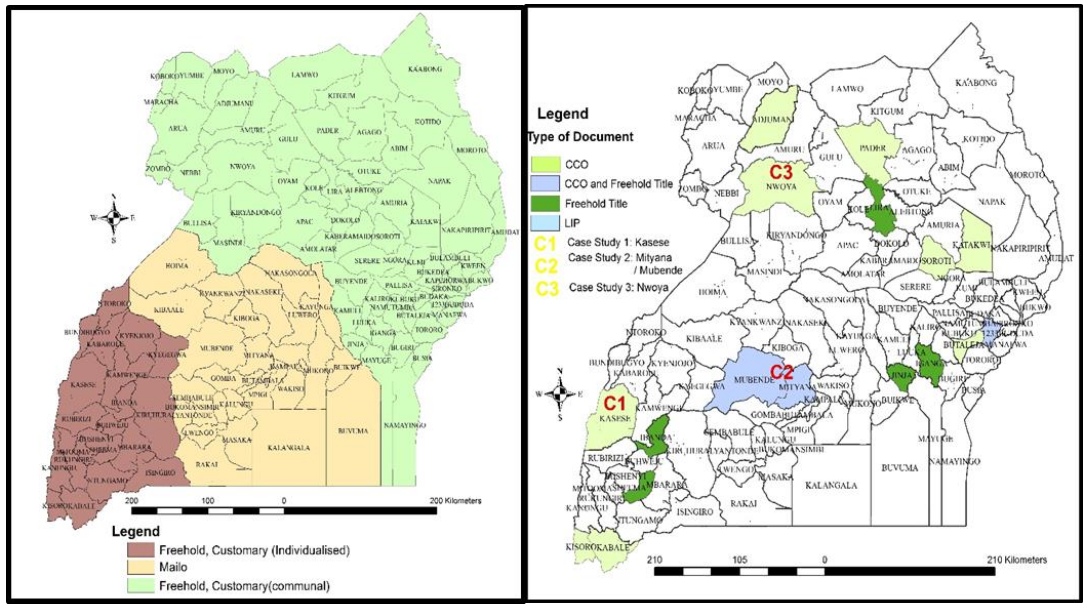
Figure 1 (left) shows the spatial location of the tenure systems in Uganda.
- (1)
Freehold is the common term for perpetual ownership of real property, or land, and all immovable structures attached to such land.
- (2)
Leasehold is the right to use property granted by the owner (lessor) to the user (lessee) for a specified period, under agreed terms and conditions. The property and immovable structures return to the lessor at the expiry of the lease. In Uganda, leases offered by the Government range from 49–99 years. Leases can be created on any of the other tenure types (freehold, mailo and customary).
- (3)
Mailo tenure is a form of freehold specific to Uganda, but introduced by the British colonialists in 1900, and predominant in Central Uganda. Under Mailo tenure, ownership is in perpetuity, but is subject to the rights of lawful and bona fide occupants. Ownership rights are possessed by a registered owner who holds a Mailo land title. The occupant can transfer user rights to a descendant (heir) but requires permission from the registered owner in order to transfer user rights to a non-family member. Mailo tenure presents one of the major land issues in Uganda [
24].
- (4)
Customary tenure, was first recognized as a formal system in the 1995 constitution. Customary tenure systems are inherently unique to the localities in which they operate and are thus difficult to characterize by generalities [
25]. Mindful of such limitations, an attempt to characterize customary tenure regimes in Uganda may yield two generic forms as explained below.
Customary tenure, predominantly individualized: Land is held customarily through inheritance (mainly) but individuals or small family units have full autonomy to decide on its use and may mortgage it or transfer their rights to community or non-community members, without consulting community leaders. The role of community leaders is limited to dispute resolution in case there are disagreements on land rights between members of the family, or between families or individuals. This type is an example of the new customary tenure systems that are emerging across sub-Saharan Africa [
26]. It has many features of freehold tenure except for the fact that land rights are not documented, boundaries are not clearly demarcated and most of the dealings on the land remain informal. This type is predominant in western Uganda.
Customary tenure, predominantly communal: Under this regime, land is owned by the community comprised of people with a common identity such as a clan. Community leaders such as clan heads, elders and family heads are responsible for allocating land use rights to the members of the community. Each family is responsible for a specific portion of the community land but is not permitted to transfer use rights to non- family or non-community members without approval of the clan leaders. This type of customary tenure is predominant in the Eastern and Northern parts of Uganda.
3.3. Evolution of FFPLA in Uganda
Uganda’s Land Act, 1998 recognized the need to document customary land rights and issue legal documents, which would serve as conclusive evidence of customary rights to land. By documenting customary land and bringing it to a formal register, this would not only secure the tenure of customary land rights holders but would enable the Government to understand the dynamics on customary land, so as to plan better for its contribution to national development. Given that most customary land owners and rights holders are peasants or small-holder farmers who could not afford the lengthy and costly procedure for obtaining certificates of title, the solution was to simplify procedures and requirements for obtaining certificates of customary ownership (CCO). Regardless of the simplified requirements and procedures, the intention was to give the CCO a legal value comparable to a freehold title. Under S.8(2) of the Land Act 1998, a holder of a CCO is permitted to: lease land or part of it; permit a person to hold usufructuary rights; mortgage or pledge all or part of the land; subdivide the land; create an easement on the land; sell the land or part of it; or dispose of the land by will.
Whereas, the law gives full rights to a holder of a CCO to transact in land as indicated above, it may be unlikely that the customary rights holders would be able to enjoy these rights in real terms [
27]. This seems to make sense given that transactions on customary land are subject to undocumented customs and traditions, more especially on customary land that is communally owned. Indeed, some studies undertaken in Uganda, for example [
28], have identified that beneficiaries of CCOS that were issued around the year 2010 were worried about the acceptability of the documents by financial institutions as collateral for loans. On the other hand, experience from other pilot areas for CCO registration in Uganda (e.g., Kasese District) undertaken around the years 2015–2016 indicate that some financial institutions had gone ahead to accept CCOs as collateral for loans. It is expected that with time, most of the limitations imposed by customs and traditions will give way to full transaction on customary land by individuals or small family units.
In Uganda, the simplification in the CCO registration procedures and requirements introduced by the Land Act 1998 included:
- (i)
Adjudication to be undertaken by a land committee located at the parish level as opposed to district level. No academic qualifications are required for one to be appointed to the committee, as long as one has extensive knowledge of land issues in the area.
- (ii)
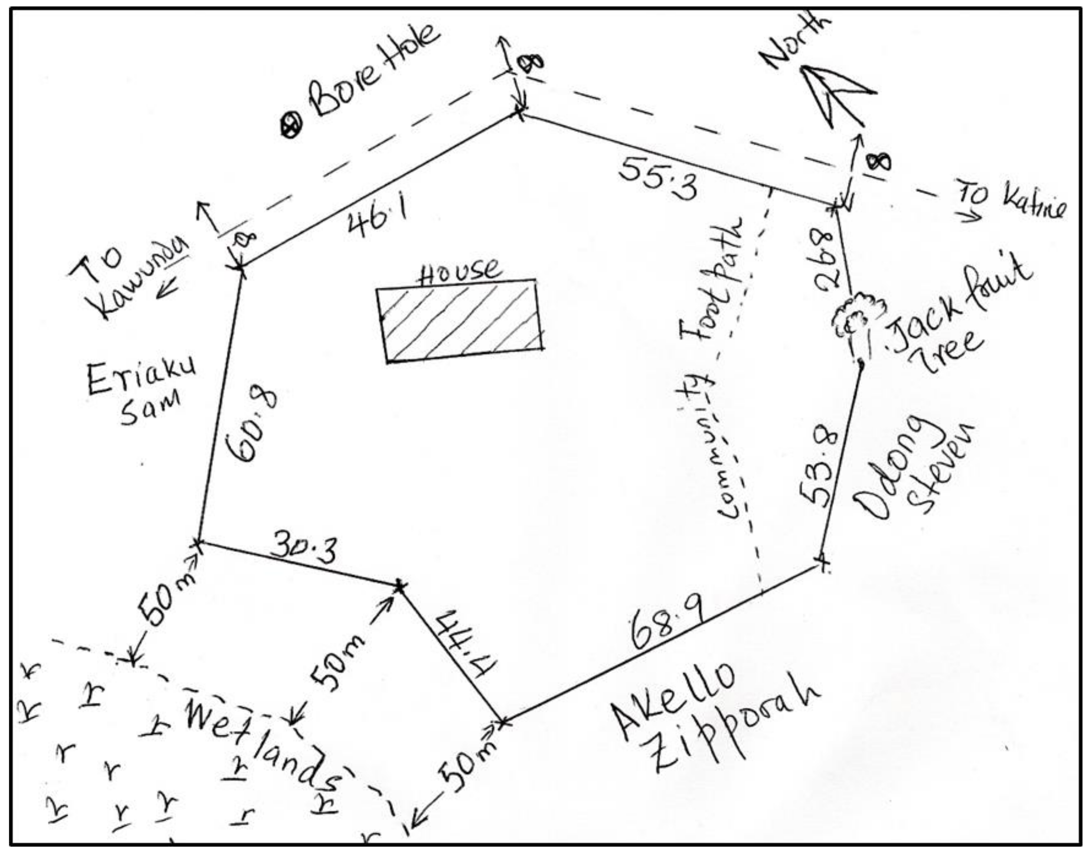
Measurement and mapping to be undertaken by the land committees, using eye judgement, pacing or measuring tape. A sketch map drawn by hand (see
Figure 2) was sufficient to issue a CCO [
29].
- (iii)
The previous legal requirement for measurement by a qualified land surveyor was removed for the purpose of registering customary land.
- (iv)
Issuance of a certificate was charged with a recorder located at the subcounty level, as opposed to a registrar at the ministry headquarters.
- (v)
The Land Registry (for both first registration and subsequent transactions) was placed at the subcounty level, down from the ministry headquarters.
The simplified procedures and requirements were not immediately implemented because of a number of technical and operational challenges. It appears that the Government had under-estimated the cost of establishing and facilitating the new lower-level land institutions across the entire country. Eventually, when the new office bearers such as members of district land boards, members of the area land committees and recorders were recruited in a few districts, they were not trained to handle the new functions assigned to them. They also lacked logistics and tools to use in their new offices. In response to this capacity gap, an amendment to the Land Act in 2004 elevated the land committees, one administrative step higher, from the parish to the subcounty level, and they were renamed, area land committees. Another constraint in the implementation was that professionals such as land surveyors were skeptical about the usability of a sketch as a replacement for a cadastral plan. Whereas as a cadastral plan drawn to scale using surveyed/measured boundaries would facilitate re-tracing of boundaries in case of disputes, the land surveyors wondered how this would be achieved with the use of a hand drawn, not to scale sketch map.
Overall, implementation of the simplified procedures therefore hit a setback essentially because of lack of capacity to implement at the local government level and lack of capacity to supervise at the central government level. Because of these and many more challenges, CCOs were not registered anywhere in the country, until 2010 when Kasese district in South Western Uganda made some initial attempts. The area land committees in the district used a combination of measuring tapes, pacing and eye judgement to produce sketch parcel maps, which would be attached to applications for the district land board to approve issuance of CCOs. However, because of default on many legal procedures and standards, the process was halted by the Ministry of Lands, Housing and Urban Development.
Another effort for CCO registration is traced back to the same period and attributed to the District Livelihood Support Program in Uganda supported by the International Fund for Agricultural Development (IFAD). The project’s land management component aimed at processing CCOs and freehold titles for customary land rights holders in 13 districts scattered across the country [
28]. Although some few manual CCOs were processed in APAC district, the process was halted in Masindi district because of the need to standardize procedures for CCO registration across the country. No CCOS were processed in the remaining districts.
The first version of modern FFPLA was introduced by FAO in 2015 under a project to operationalize the Voluntary Guidelines on the Responsible Governance of Tenure (VGGTs). Under the project, more than 4000 CCOs were registered on customary land using Sola Open Tenure, a fit for purpose tool for documenting land rights. The experience from the FAO-supported project led to a multiplicity of other small-scale projects for registering customary land rights and formalization of tenure for occupants on registered mailo land using recordation tools. As of today, more than 150,000 parcels have been documented through such pilot project using FFPLA tools in various parts of Uganda (see
Figure 1, right).
4. Description of Case Studies for FFPLA in Uganda
FFPLA pilot projects in Uganda number more than ten. However, in this paper, only three case studies have been reviewed to provide lessons for developing a country implementation strategy for FFPLA. To provide a balanced review, the first case study was selected from a region of predominantly communal customary tenure (Nwoya in Northern Uganda), the second case study was selected from a region of predominantly individualized customary tenure (Kasese in Western Uganda) and the last case study was selected from a region of customary tenants on registered mailo tenure (Mityana/Mubende in Central Uganda.
4.1. Case Study C1—Registration of CCOs in Nwoya District, Northern Uganda
Nwoya district is part of Acholi sub-region in Northern Uganda. The district is a center of attraction for the numerous natural resources that it has, such as the Murchison falls on the River Nile, Murchison Falls National Game Park, Lake Albert and the oil rich Western Rift Valley—the Albertine Graben. All in all, 91.1% of the total population in Nwoya district is engaged in subsistence crop farming, making land a very vital asset, crucial for livelihood [
30].
In March 2015, ZOA, a civil society organization based in Uganda received funding from a private foundation in the Netherlands to support a community-led land dispute mediation and customary land tenure registration. The project had two specific objectives, namely: (1) more farmer-households to feel secure about their land rights for investing in agriculture and intensify production; (2) government institutions, civil society and community leaders take steps to ensure that customary tenure registration contributes to productive land use and does so in an inclusive and equitable manner. Subsequently, ZOA signed a memorandum of understanding with the Makerere University School of the Built Environment to provide technical assistance in the implementation of the project. Makerere University used its experience from implementation of a similar project in Kasese District to guide the processes for adjudication, demarcation, mapping and issuance of CCOs.
Parcel demarcation was based on a participatory approach [
16,
31], while taking into consideration the legal requirements for adjudication of rural land in Uganda. It was undertaken by area land committee members (formal local land institutions), Rwot Kweri’s (local chiefs with knowledge of family land boundaries), elders (community representation), local councils (government village committees), ZOA field staff (back up trainers and a group of young educated persons from the district (volunteers) who supported the above institutions in the fieldwork and use of technology. (Note that Makerere University trained locally recruited volunteers and ZOA staff, who later become trainers for area land committees during fieldwork). Demarcation work would start after payment of a nominal fee of 10,000 Uganda shillings (2.5 US cents) and filling an application form. Data capture was planned to follow simple field procedures, borrowing from regional and international experiences [
17,
31,
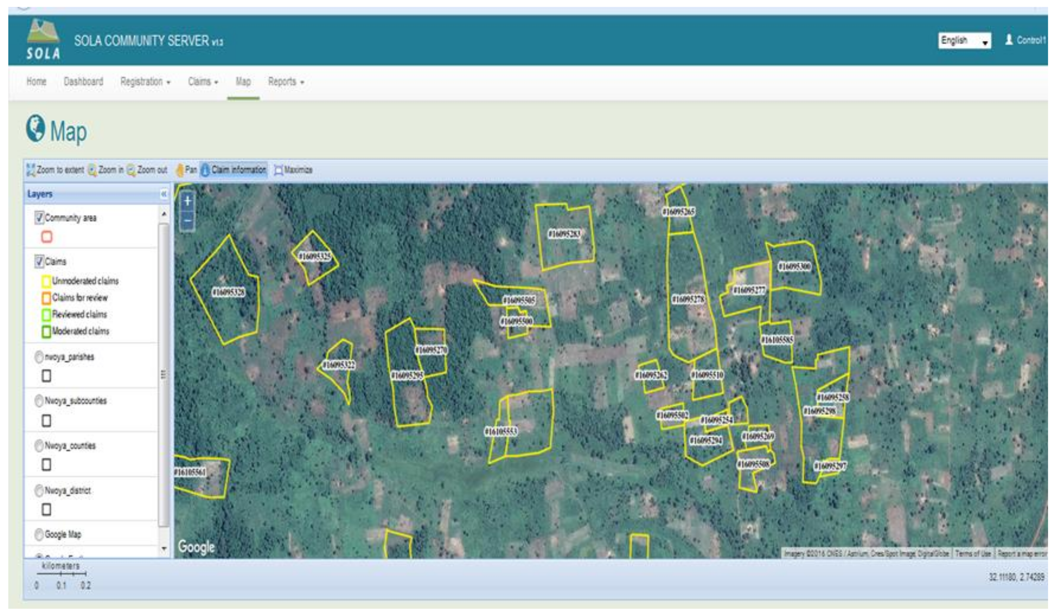
32]. The project used SOLA Open Tenure (see
Figure 3), previously customized for a similar project in Kasese district. More than 1000 CCOs were generated and issued to the beneficiaries. Dispute resolution was based on tested alternative dispute resolution mechanisms [
33,
34] to avoid the costly and lengthy option of litigation. It was accomplished, through mediation by the Acholi Religious Leaders Peace Initiative, previously formed to deal with war conflicts between the Government and the Lord’s Resistance Army of Joseph Kony [
35].
The success of FFPLA tools in securing tenure rights of customary land rights holders in Nwoya was instrumental in opening up land tenure regularization projects in Northern Uganda. Apart from scattered freehold titles which had been issued to privileged individuals in the region, there had not been any effort to issue any other legal documents on customary land rights in Northern Uganda. Given that northern Uganda was a post-conflict zone, having been affected by a civil way for more than two decades, land disputes involving returning citizens were widespread. The war had disorganized family structures, some members had fled the country, while others had relocated. There was a thinking among some local civil society organizations that registration of land tenure rights and issuance of legal documents should delay for another 50 years to allow for the families to re-organize. These sentiments were shared in the Northern Region Land Platform meeting that took place in Lira in 2016. There was also fear among potential actors in land regularization that Northern Uganda was a no-go zone for any land regularization program. The project therefore opened gates to many subsequent fit for purpose land administration projects, which have greatly improved land tenure security of customary land rights holders in Northern Uganda.
4.2. Case Study C2—Registration of CCOs in Kasese District, Western Uganda
Kasese district is situated in western Uganda next to DRC between the Kazinga Channel, Lake George and Lake Edward. Agriculture is the primary economic activity in Kasese District and employs over 69% of the total population with the majority of farmers (65%) in the district practicing small scale subsistence agriculture [
30]. Land in Kasese was traditionally held in trust for the community by ridge leaders referred to in the local vernacular as “Mukulu wa Bulhambo”. The most common form of land ownership today is by individual families (usually the nuclear family) with a few cases of land being jointly owned by groups siblings (the extended family) and referred to as “Clan Land”.
Kasese District Local Government took advantage of the provisions in the Land Act 1998 and Local Government Act 1997 to embark on CCO registration independent of the Central Government, as provided for under the law. Given that the Ministry of Lands, Housing and Urban Development had not extended capacity building support to the district, the district lacked skills to independently register CCOs. Therefore, the Ministry of Lands, Housing and Urban Development, using its supervision and monitoring role under the Local Governments Act [
36] S 97, halted the procedure in order to review and ascertain that the generated CCOs conformed to the required standards. The FAO supported project, therefore, came in at the request of the Ministry of Lands, Housing and Urban Development to improve the existing process of CCO registration, by substituting crude methods of generating a sketch map with IT-based tools built in SOLA open tenure land rights documentation tool. Furthermore, the FOA supported project aimed at raising awareness on VGGTS [
37] and capacity development of local land administration institutions at subcounty and district level for CCO registration.
In partnership with Makerere University School of the Built Environment, the project trained members of the area land committees, members of dispute resolution committees, the recorders and locally recruited volunteers in CCO registration, using a customized version of SOLA open tenure. Essentially, the project replicated the methodology explained under
Section 4.1 above. SOLA open tenure [
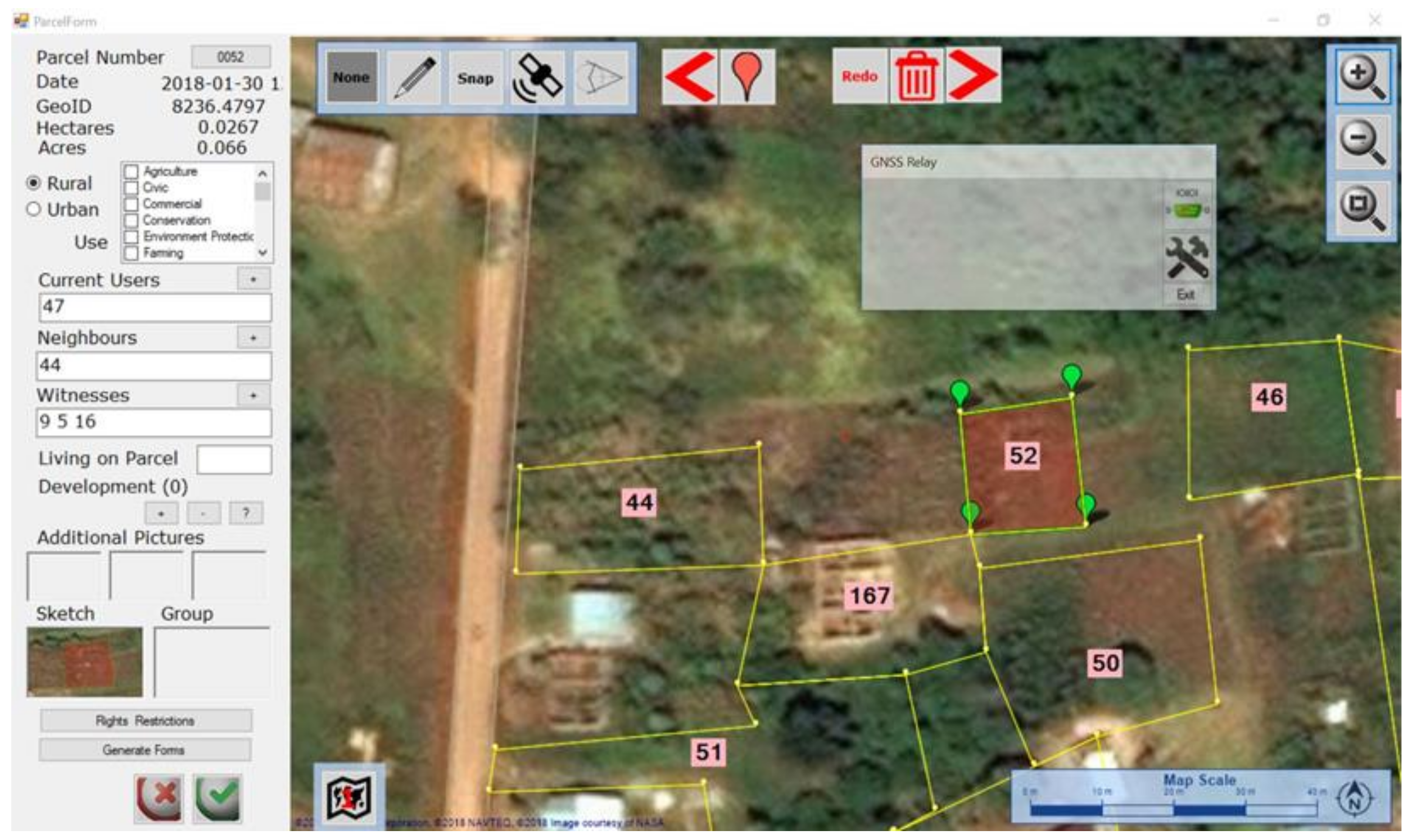
38] incorporated many fit for purpose land administration tools such as ability to use a tablet and satellite image to map parcels and record land rights data by low skilled persons (see
Figure 4).
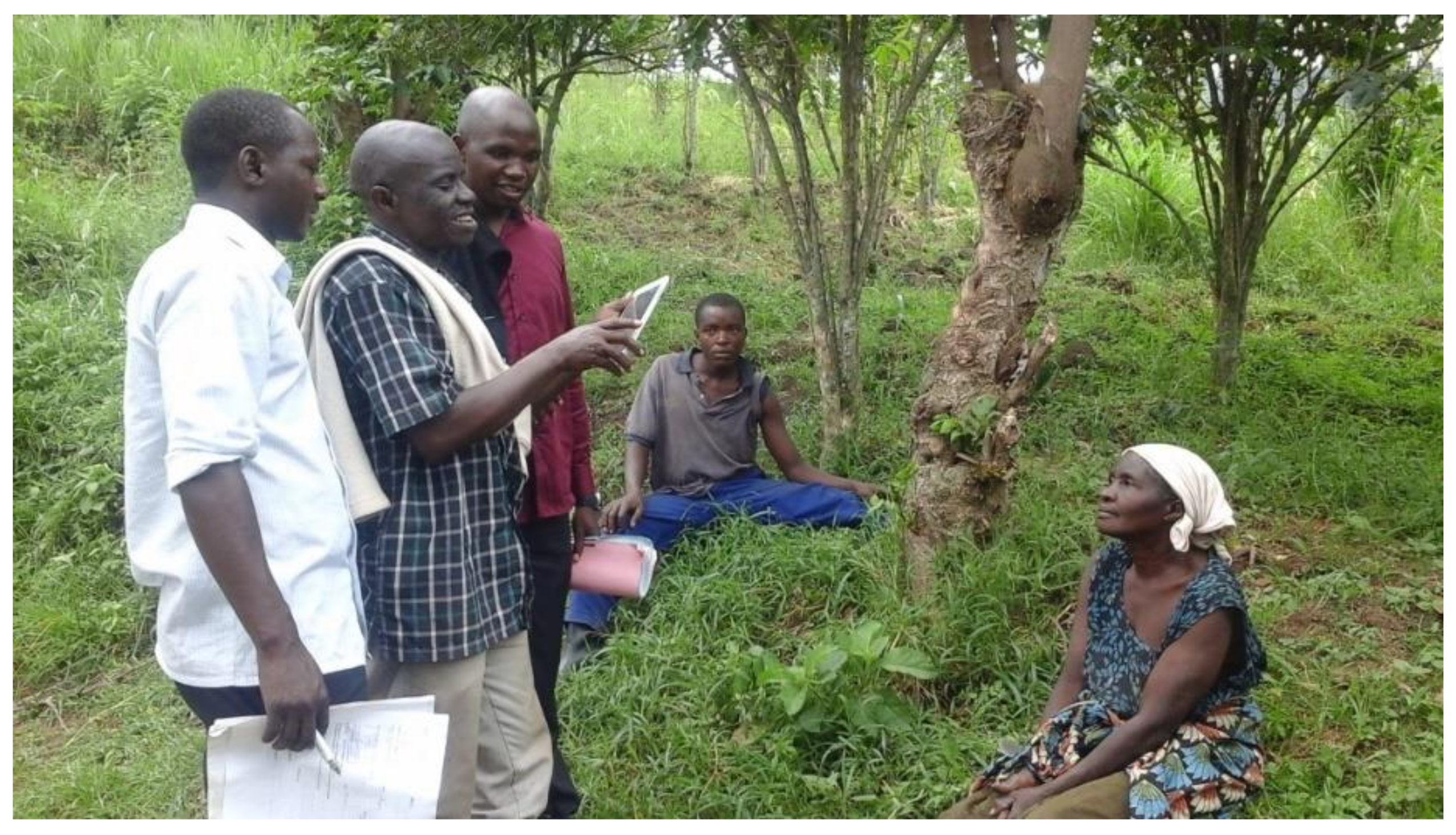
Each field team responsible for data collection comprised of a member of the area land committee (government representative), a student surveyor from Makerere University (technology transfer trainer) and a locally recruited volunteer (back up trainer). The volunteer was necessary, given that members of the area land committee who are mandated by the law, to undertake adjudication were in many cases, illiterate or too old to withstand the harsh field conditions. The data generated was subjected to quality checks by Makerere University, Ministry of Lands, Housing and Urban Development and the District Land Office staff, before submission to the District Land Board and subcounty for issuance of CCOs.
Through this project, more than 4000 CCOs were processed and issued to the beneficiaries. The project did not cover the entire district because of financial scope although the demand for land tenure security was very high among the land owners. The project was instrumental in demonstrating that fit for purpose tools could be used to improve the sketch map hence producing parcel maps to support CCO registration. The project also demonstrated that generic FFPLA tools could be customized to align with a country’s legal requirements for land administration.
4.3. Case study C3—Land Inventory Protocol (LIP) in Mityana and Mubende Districts, Central Uganda
Since colonial times, and after independence, the most intractable policy issue facing the Government of Uganda was undoubtedly the future of Mailo land [
14]. Whereas the Land Reform Decree of 1975 took a radical approach to address the mailo tenure issue, the Land Act (1998) acknowledged the legal and practical difficulties of pursuing a similar trend. The Land Act (1998) recognized the lawful and bona fide tenants while the Uganda National Land Policy (2013) further provided for rights and responsibilities for both the tenants and landlords on the Mailo land Tenure system to ensure an amicable relationship on the dual ownership of land use rights. The land policy further provided a basis for various options to unravel the complexity of dual rights over the same land. These options include: buying out, sharing, leasing and registration of occupancy (bona fide or lawful). Unfortunately, very few Ugandans living on mailo land are knowledgeable about the available provisions in the National Land Policy of 2013, the most un-informed being women and vulnerable groups in the rural areas. Since the Land Act was formulated in 1998, many interventions had been made by government in partnership with development partners to secure land rights across the different tenure types. However, no interventions had been conducted on private mailo land tenure and yet it hosts most of the complicated overlapping land rights.
GIZ (German International Development Agency) with support from EU and the German Federal Ministry of Economic Cooperation and Development (BMZ) under the Special Initiative “One World, No Hunger” [
39] implemented a project to improve land governance in Uganda. Project activities were implemented in partnership with Makerere University School of the Built Environment, Ministry of Lands, Housing and Urban Development and the respective local governments. The project was implemented in Mityana and Mubende districts in central Uganda, with plans to extend it to more districts.
The land inventory was undertaken by field teams comprised of University students (as trainers), area land committee members (local land institution), members of local councils (government village councils), locally trained land administration assistants (technical assistants), and locally trained paralegals (for dispute resolution) [
24]. Mobilization and sensitization of communities was undertaken by a local civil society organization while overall monitoring and policy support was provided by the Ministry of Lands, Housing and Urban Development. GIZ provided overall technical and management support. Land rights documentation was accomplished using a land rights documentation and mapping software tool named CRISP, developed by GIZ but customized to the land administration system in Uganda. CRISP, which is an acronym for Cadaster and Rights Inventory Saving Paper, has both social and spatial data collection components. The social components of the tool conform to the concept of continuum of land rights [
40]. They were used to collect information on tenants and parcels which included: the tenants’ biodata, land use, and number of people living on the parcel. The tool also captured the name of the landlord, the nature of tenant’s occupancy and encumbrances on the parcel, (if any). CRISP spatial components in conjunction with the Global Navigation Satellite System (GNSS) receivers (EMLID type) were used to draw parcel boundaries and to input additional information such as the village, parish, subcounty, county and district to which the mapped parcel belonged. CRISP also offered provisions for generating the final land inventory documents—the LIP and a geo report.
Figure 5 demonstrates the CRISP graphical screen for generating parcels in the pilot project undertaken in the Mityana District, in Central Uganda.
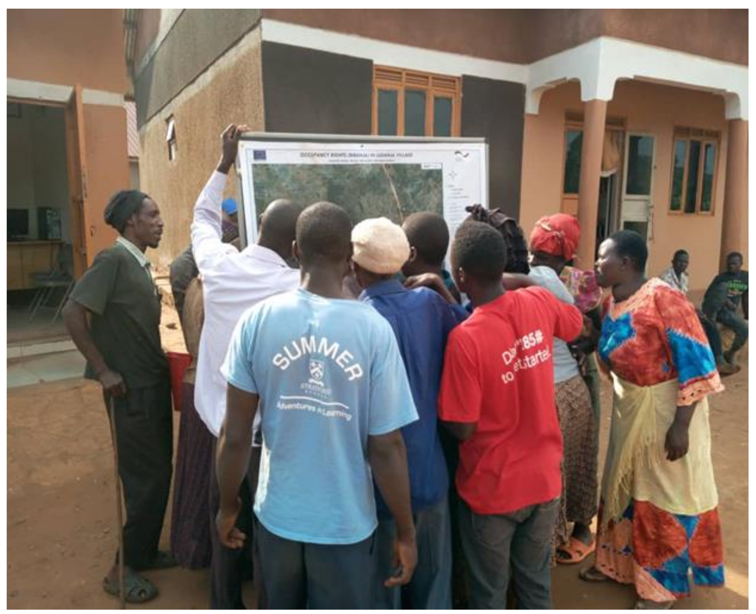
Once parcels for all consenting tenants in a village were mapped, and disputes resolved through mediation by the locally recruited and trained paralegal, a village map would be generated, displayed on village noticeboards and verified by all the occupants and interested parties. This would be followed by issuance of social documents named land inventory protocols (LIPs) to occupants upon paying Uganda shillings 10,000 (2.5 US Cents) per LIP/parcel.
Figure 6 shows one of the village maps being verified by occupants in the Mityana District, central Uganda. It should be noted that the use of paralegals for mediation replaced the need for professional lawyers and fitted well within the Principles of FFPLA [
15,
16].
The project documented more than 30,000 parcels, which resulted into improved relationships between landlords and tenants; because of this exercise, landlords got to know who their tenants were and vice versa. The benefits and detailed evaluation of the inventory approach for land rights recordation are well document, for example see [
24].
5. Lessons Learnt from Pilot Projects in Uganda
5.1. Lessons Learnt for Building the Spatial Framework
The approach is easy to implement: One of the international lessons from implementation of FFPLA as documented in [
14] is that the approach should be easy to implement. The experience from the case studies in Uganda, has also revealed that the approach for generating the spatial framework is not only very easy to implement, but also easily understood by local communities. In all the three case studies, it has been established that locally recruited land administration assistants (within subcounties), with high school education, can be trained in a period of five days to generate parcel maps and land rights descriptive information using FFPLA data collection equipment and software. The easy-to-use FFPLA graphical tools such as those built in, Sola Open Tenure and CRISP recordation software provide an opportunity for low-skilled persons to draw and view parcels as vector overlays on high resolution satellite images or ortho-rectified aerial images while in the field. Additionally, some of the recordation tools allow for drawing of parcels on hardcopy images while in the field and later digitizing them in the office. The possibility of displaying parcel maps and enabling community members to view the shapes and location of their parcels while in the field, makes it easy to obtain community buy-in.
Opportunity to cover the entire country within a few years at a low cost: The FFPLA approach has enabled mapping and capturing land rights information in a rapid manner. In Kasese and Mityana/Mubende case studies, where parcel sizes are smaller (2 acres on average), each field team was able to map and capture land rights information for 15–30 parcels per day. However, in Nwoya case study where parcel sizes are larger (50–200 acres) due to communal ownership, each field team was able to capture land rights information for 5–15 parcels per day. The variation in daily outputs can be explained by variations in the terrain, size of parcels and weather conditions.
There is potential to increase the daily output, if a systematic procedure of documenting all the parcels in an administrative unit, is adopted. Under a systematic approach, a field team builds a spatial framework by starting from one location and follows an orderly schedule, documenting all the adjoining parcels in a universal manner, before moving to another administration unit [
41], p. 690. However, in the reviewed case studies, the pace was affected by the legal requirement for consent by individuals/communities before documenting their parcels [
42]. Such endorsements require extensive public information and a communication campaign which slowed down the pace of field teams.
It was also established that despite the extensive sensitization through radios, community meetings, mobile loud speakers and house to house mobilization, a few land owners were still reluctant to participate. Such land owners would be skipped and left to decide as the teams moved ahead to document parcels for consenting land owners in the same village. This eventually made the process semi-systematic, hence falling short of some of the key benefits of a systematic approach to land titling [
43]. In each of the three pilot areas, five teams were deployed to work concurrently and a supervisor (either a land surveying student or graduate land surveyor) was recruited to monitor the quality of the generated spatial framework. Despite the limitations with a semi-systematic procedure, the daily output for the five teams in each pilot area was 50–150 parcels, and 150–300 across all the three pilot areas. This compares with daily outputs in other countries where FFPLA has been piloted [
16]. These results demonstrate that using a national approach, it will be possible to work in parallel throughout the country and hence complete the entire a country in a short time.
Multiplicity of various recordation tools: Many innovative tools have been developed for recordation of land rights worldwide [
44]. This presents both opportunities and challenges. For the three case studies reviewed in this paper, two recordation tools, namely Sola Open Tenure and CRISP were identified. Both tools can run on tablets, hence presenting advantages of directly entering land rights data into the database [
45], p. 16. These two tools have variations in the data formats and outputs, which makes it cumbersome to eventually collate and generate a consistent spatial framework. Variations were observed in data input requirements, data types and data output formats and products. For a country like Uganda, which has already invested in establishing a national land information system, generating parcels without following a uniform and consistent standard defeats the purpose for the heavy investment in system development. The ongoing efforts to establish a CCO working group in the Ministry of Lands, Housing and Urban Development is considered to be a good step towards building a consistent spatial framework that is hinged on FFPLA principles
New spatial framework comparable to the National Cadastral Database: The spatial framework generated under the three case studies was based on simplified FFPLA techniques. In all the three cases, either geo-referenced satellite images or ortho-rectified aerial images were used to digitize the parcels. Such images are highly recommended for generating a spatial framework because of the low lost [
45]. When compared with the existing cadastral maps with their constraints [
46], the new spatial framework presents better accuracy in adjacency although the absolute accuracy is still lower, but could be upgraded over time. Incremental upgrade is indeed a key principle of the FFPLA approach [
15], implying that, at a later date, this framework may be improved to support many other functions, should need arise. The framework in its current form may support functions such as rapid physical planning, land use planning, environmental planning/management and preliminary infrastructure planning. Furthermore, given that land owners or rights holders visually verified the shapes and location of their parcels during village display, the acceptability of the framework is much higher than the current cadastral database.
5.2. Lessons Learnt for Building the Legal Framework
Improved possibilities under the existing legal framework: The implementation of pilot projects on FFPLA in Uganda benefited from relatively recent laws that were enacted after the 1995 constitution. Such laws include the Land Act (1998), the Local Government Act (1998) and the Local Council Courts Act of 2006. These laws incorporated some aspects that favored FFPLA implementation, though not comprehensively. The laws provided for: registration of CCOs using FFPLA-like simplified procedures; establishment of customary land registries at subcounties (2004 amendment) which are closer to the people; dispute resolution on customary land to be handled by a village local council as the first court of instance; and land management to be a responsibility of decentralized and semi-autonomous local governments. On the other hand, some laws such as the Survey Act 1939, though old, included flexible provisions that gave powers to the Commissioner of Surveys and Mapping to decide on procedures and standards for measurement and documentation of parcels. Such provisions made it possible to use FFPLA tools to generate spatial frameworks for other land tenure systems such as freehold, which are not well covered under the land Act 1998. However, the laws will require revision, if they are to support full realization of the benefits of a fit for purpose approach to land administration.
A systematic approach is a must: As mentioned in the paragraph above, pilot projects on FFPLA are largely implemented within the framework of existing laws. Both the Land Act 1998 and the Registration of Titles Act 1965 prescribe a sporadic approach to land registration. The major assumption under the two laws, and their respective regulations, is that one applicant is handled at a time from land inspection up to the production of the final certificate. This approach is not only inconsistent with FFPLA principles [
15] but is slow, expensive, discriminatory and does not help to cover the country in a short time. In all the three case studies under review, the implementers suffered delays resulting from absence of laws that prescribed a systematic approach to land adjudication. The field teams were able to cover many parcels in a day, but the approval procedure required preparation of individual files for each parcel, ensuring that all the necessary legal attachments were included, and separately processing each application up to final approval by the District Land Board. Such duplications can be avoided if a new law that provides for mass data collection, mass processing and mass approval is put in place.
Handling of existing and new land disputes: In Uganda, the legal framework for land dispute resolution includes formal courts, local councils and informal institutions such as traditional leaders [
33]. In all the three case studies under review, disputes were resolved through mediation, which is the preferred alternative dispute resolution (ADR) mechanism under the Ugandan legal framework. The more complicated long-standing disputes and those where parties could not reach an agreement were referred to the court for settlement. Furthermore, in each of the pilot projects, dispute resolution committees were formed at the commencement of the project. In the Kasese case study, the dispute resolution committees comprised of members of the local councils and respected persons selected from the communities. In Nwoya case study, the committees comprised of elders, traditional chiefs (Rwot Kweris) and members of the Acholi Religious Leaders Peace Initiative (ARLPI). ARLPI is an umbrella organization for the major religious denominations in Northern Uganda. Its goal was to pursue peaceful conflict resolution with the Lord’s Resistance Army. While in Mityana/Mubende, the committee comprised of local councils, locally recruited and trained paralegals, and staff from a local civil society organization. The effectiveness of ADR was manifested in the escalation of disputes at the beginning of the project and substantial reduction towards the end. For example, in Kasese district, 33 disputes were reported in 2015 at the commencement of the project, 39 disputes were reported in 2016 mid-way the project and only six disputes were reported in 2017, towards the end of the pilot phase [
47].
5.3. Lessons Learnt for Building the Institutional Framework
Decentralisation of land services: The institutional framework for land adminstration in Uganda includes national institutions, local institutions and informal but legitimate institutions. Having a mix of formal and informal (but legitimate) institutions in a land administration system promotes flexibility and good land governance rather than bureaucratic barriers [
48], hence conforming to the principles of a FFPLA approach. In each of the three case studies, the success of the pilot project was hinged on the availability of land institutions at the subcounty level and the district level. The subcounty level institutions included the area land committee and the recorder. The area land committees were responsible for receiving applications, land inspection and compiling information that would help the district land board to make a decision on whether to grant a CCO or not. The information compiled by the committees included a duely filled and signed application form (The form is filled by the applicant and endorsed by area land committee members. The committee may help applicants who are illiterate); recommendation and minutes by the area land committee; an inspection report; and a sketch plan of the land which was the subject of the application. The law requires that at least three of the five members must inspect the land before compiling a report. This would imply that only one adjudication team should be deployed in one subcounty to carry out land inspection at any one given time. Meeting this legal requirement became cumbersome given that under the pilot projects, outputs were required in a very short time. Eventually, in total disgard of the legal provisions, and in consultation with the Ministry of Lands, Housing and Urban Develoment, five teams were deployed to work concurrently, in each subcounty, with a representation of only one member of the area land committee on each team. For purposes of future systematic registration projects, it will be necessary to review the provision that requires all committee members to be present during inspection. In any case, the level of transparency under the systematic approach is adequate to prevent any likely corrupt or fraudurent tendecies that the law intended to mitigate.
The recorder is resposnsible for registration and issuance of the final CCO. The subcounty chief (Senior Assistant Administrator) is the Head of Civil Service in a subcounty but was assigned the recorder role under the Land Act of 1998. The recorder is the equivalent of a Registrar of Titles under the Registration of Tiles Act. The recorder manages land records at the subcounty including generating the first registration records and managing subsequent transactions such as subdivisions, transfers, mortgages, and caveats, etc. The benefit of assigning recordation roles to a government officer at the subcounty is the easy accessibility to land services by the local people. However, the biggest limitation is the enormous investment required in training recorders and establishing/equipping functional land registries at the subcounty level. As of 2006, there were 943 subcounties in Uganda and this translates to 943 recorders and 4715 (5 × 943) members of area land committees to be trained.
Another critical issue encountered in the case studies was lack of legal provision for the age limit and qualifications of the members of area land committees. Whereas one needed to be an adult with a wide knowledge of land issues in the subcounty to serve on the committee, there was no requirement for age limit. Indeed, most members of the area land committees were elderly and either illiterate or semi-illiterate. It was not possible for the elderly to walk for long distances under harsh terrain and weather conditions, to adjudicate land rights and generate the daily targets of 10–30 parcels. Furthermore, the illiterate committee members required support to review and validate what the applicants had filled in the application forms. It is because of such limitations that the pilot projects solicited additional support from locally trained young persons capable of taking on the load to meet the daily targets. For the future systematic registration projects, there will be a great need to legalise the involvement of such young localy recruited persons in the institutional framework for CCO registration.
Requirement for strong political will as well as the support of key senior civil servants: The FFP approach is a national, top-down approach and requires strong political will and the support of key senior civil servants [
14]. Indeed in all the three case studies, the initial permission to work in the project area was granted by the Ministry of Lands, Housing and Urban Development Political Head (Cabinet Minister) and the Technical Head (Permanent Secretary). The role of the top political and senior civil servants was to ensure that the project goals and deriverables fitted into the national development goals and government policy frameworks. At the distrcit local government level, support was sought from the District Political Head (LCV Chairperson), the Head of Civil Service in the District (Chief Administrative Officer—CAO) and the Central Government Representative in the District (Resident District Commissioner—RDC). In addition to the above, consent was sought from the respective members of parliament who would in turn build the trust of the local communities, by explaining the benefits of the CCO registration project. At the subcounty local government level, consultations were made with the Political Head (LC III Chairperson) and the Head of Civil Service (Subcounty Chief).
The project structure in each of the three case studies included a monitoring committee comprised of senior officials from the ministry headquarters, officers from the land office and the district and academicians from Makerere University, who provided technical back-stopping/support. The monitoring committee would visit the project site once a month. Another lower level committee included techncail officers from the district land offices and resident project coordinators (land surveyors) who provided direct support to the field teams, once a week. The role of the implementing a partner such as a civil society organisation or development partner organisation, was to provide financial support, build capacity and provide technical support to enable government institutions run the process in accordance with the legal provisions.
Ensuring sustainability of the fit for purpose approach to land administration: The longevity of projects will best be achieved through planning for sustainability from the start, including planning for long-term financial health, e.g., assessing total cost of ownership [
49], p. 76. The need for ensuring that maintenance/updating takes place from day one is a lesson that informed the country implementation strategy. In the three case studies, sustainability was a factor put into consideration, the usual limitations of a project-based approach notwithstanding. All the case studies included components of training as a means of empowering land institutions to handle all the processes at the expiry of the pilot projects. In addition, the projects levied nominal charges for land services, which funds would be paid directly to the local governments. Indeed, applicants were required to pay mandatory application fees and issuance fees [
42] totalling to Uganda shillings 20,000 (US 5 cents) per application/parcel. The pilot projects had however, not developed any guidelines for handling post registration transactions, which are considered necessary for keeping the registry updated. This omission became a lesson to consider while developing the FFPLA country implementation strategy.
6. Developing a FFPLA Strategy for Country Implementation
The development process for the country strategy for implementing FFPLA in Uganda was informed by the lessons learnt from the pilot phases and followed the phases below.
6.1. Identification of the Stakeholders
It became clear from the case studies that without involvement of key stakeholders, any efforts to implement FFPLA would be futile. Therefore, the first step in developing the Uganda implementation strategy for FFPLA was to identify stakeholder institutions and their anticipated roles in implementing the strategy. The roles were determined based on the provisions in the existing land laws and the experiences from the accomplished or ongoing FFPLA pilot projects. Stakeholders are required for financial mobilization, granting political approvals; collecting baseline information; mobilizing district and subcounty local support; training of stakeholders; community sensitization and mobilization; adjudication; dispute resolution; undertaking field measurements; quality control of data, processes and products; approving applications; and final processing and issuance of CCOs or other legal land tenure security documents to beneficiaries.
The identified stakeholders included politicians, ministries (Lands, Housing and Urban Development, Finance and Economic Planning, and local government), development partners and donors, professional bodies (e.g., the Uganda Institution of Surveyors), universities and training institutions, civil society organizations, district level government, the district land board and land office, area land committees, and traditional/religious institutions. The above-mentioned stakeholders played an important role during the pilot phase and were, therefore, considered essential for the implementation at national level.
6.2. Designing the Guiding Principles
The guiding principles serve as the basic foundation for making decisions on the provisions for the spatial legal and institutional components of the strategy. The international guidelines [
15] provide a good basis for defining the national guiding principles. However, when combined with experience from specific pilots undertaken in the country, this provides more practical tested guidelines for the strategy. In the case of Uganda, the pilot projects had already tested the most acceptable methods for generating the spatial framework, the acceptable dispute resolution mechanism and composition of ADR committees, the gaps in the legal framework, and the necessary adjustments to institutional framework in order to support FFPLA. Most of the included guiding principles had been previously discussed with the major stakeholders during workshops organized by the implementers of the pilot projects. The role of the framers of the strategy was to confirm acceptance of the principles during the final phases of presenting the draft strategy.
6.3. Deciding on key Actions in the Strategy
Key actions of the strategy are those interventions necessary to transform the existing spatial, legal and institutional framework to comply with FFPLA principles. The actions, therefore, depend on the extent to which the current frameworks deviate from the FFPLA principles. In Uganda, the pilot projects had, to a large extent defined the desired standards for the spatial framework, including which technologies were feasible, what data would be collected on each parcel, how parcels would be represented graphically and so on. It was, therefore, easy to identify which actions were necessary to achieve those standards.
Furthermore, the pilot projects had revealed gaps in the legal framework that would affect the implementation of a FFPLA approach. During the pilot phase, the existing laws made processes such as systematic adjudication, mass processing of CCOs, and dispute resolution very slow and more cumbersome. The proposed actions under the legal framework component were therefore about reviewing the current laws to support the functioning of the spatial and institutional framework under FFPLA principles. On the other hand, the institutional framework was largely compliant with the FFPLA principles. No major proposals were made to change the setup of the existing land institutions, except formalizing the role of locally trained land administration assistants and providing for more inter-institutional collaboration. Most of the actions were aimed at building the capacity of the institutions so as to make them more efficient, effective and sustainable.
6.4. Deciding on Phasing and Costing of the Strategy
Decisions for phasing and costing of the country implementation strategy were primarily based on the country experience, while taking into consideration the best practices from international experience. The full implementation was organized into four phases, in order to facilitate learning, reflection, monitoring, and evaluation. An initial phase of one year focused on getting started, providing the infrastructure and technologies, revision of laws and regulations, testing various processes and recordation of about three million parcels. Phases Two and Three of three years each, were planned as the production phases aiming at covering about 18 million parcels in total. The fourth phase was planned for completion and sustaining the systems for future operations.
Regarding the costing of each parcel, the international experience has shown that amounts are usually in the range from US
$1 as in the case of Ethiopia [
50,
51], US
$6–8 as in the case of Rwanda [
51], US
$7 in general [
45] but should not exceed US
$20–30 [
52]. In Uganda, experience from the pilot projects point to a range of costs from US
$10–US
$25 depending on the size of the parcel, its location and the technology used for measurement. However, by streamlining the processes of mapping and recordation, the costs are estimated as
$10 USD per parcel, equivalent to around
$230 million USD for covering 23 million parcels.
Experience from the pilot projects has also identified the need to establish basic infrastructure at the sub-counties in order to support and manage the records generated from the registration exercise. The infrastructure includes strong rooms and filing cabinets for storing manual records, electricity and computers for digital processing of data. Further costing relates to capacity building activities, awareness campaigns, and various managerial issues related to drafting of manuals, guidelines, supervision, monitoring and evaluation. These additional support costs are estimated at US $270 million. The full implementation is then designed in four phases over a 10-year period for a total cost of $500 million USD.
6.5. Soliciting Stakeholder Input and Endorsement
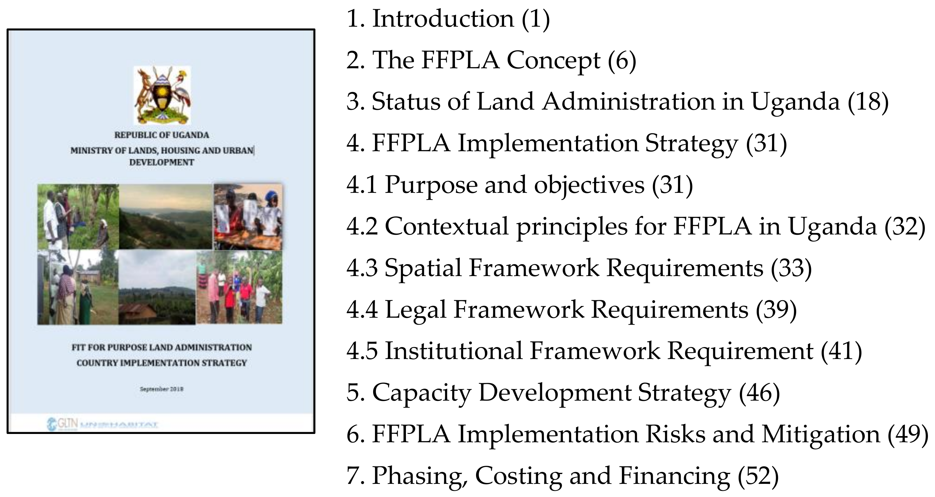
The final process in the development of the strategy was stakeholder input and endorsement. The identified stakeholders were invited for a workshop in which the draft strategy was presented. Some of the stakeholders had participated in previous workshops separately organized by implementers of the pilot projects. In addition, some of the stakeholders had participated in the pilot projects under various roles as data collectors, supervisors, quality controllers or respondents during baseline data collection. The strategy drafting team therefore took less effort to obtain stakeholder endorsement. For special stakeholders such as land surveyors, two separate workshops were organized targeting the institution of surveyors of Uganda and government surveyors, respectively. In both workshops, the major issues advanced by the surveyors were on quality of data generated and the role of surveyors under the new strategy. Given that land surveyors were the major drivers of the pilot projects, it was easy to build their confidence about their continued involvement and leadership under the new strategy, although the actual field work would be carried out by local teams as under the pilot projects. The cover page and summary outline of the strategy is demonstrated in
Figure 7.
6.6. Strategy Approval and Implementation
The draft strategy has to go through various stages before it is gazetted as a national strategy for FFPLA implementation. Initially, the strategy has to be reviewed by a technical committee comprised of government surveyors at the ministry and in the ministry zonal offices, and this has already been accomplished. Thereafter, the draft should be presented to the top management team of the ministry, chaired by the Permanent Secretary, Ministry of Lands, Housing and Urban Development. Finally, other stakeholders including Ministry of Justice and Constitutional Affairs, Ministry of Local Government, and professional bodies will provide input before the Minister of Lands, Housing and Urban Development signs it off as a national strategy.
7. Discussions on Developing a Country Strategy for Implementing a Fit for Purpose Approach to Land Administration in Uganda
Discussions on the Provisions for a Spatial Framework: The spatial framework is the basic, large-scale map showing the way land is divided into spatial units [
15]. It accounts for the largest portion of the initial costs for building a land administration system. In Uganda, the FFPLA country strategy comes at a time when there is no updated law that comprehensively guides the compilation of a spatial framework. The Survey Act of 1939 and its subsidiary law, the survey regulations are out of touch with modern techniques have already been put aside [
55], implying that survey observation, checking and plotting are not fully guided by the law. The current spatial framework is, therefore, full of errors such as overlaps in parcel boundaries. On the other hand, the FFP approach for generating a spatial framework in which visual, as opposed to measured boundaries have been advocated [
56] and proven to be pro poor [
14,
31]. In Uganda, the FFP approach for generating a spatial framework is, to a small extent, embedded in the Uganda Land Act of 1998, but is restricted to regularization of customary tenure and lawful or bona fide occupancy rights on registered land. This approach has already been improved through the various FFPLA pilot projects in Uganda.
The three case studies reviewed in this paper have demonstrated that it is easy to generate a spatial framework for the entire country within a period of 10 years, targeting 23 million parcels. This is possible at low cost given that Uganda has already invested in a country-wide base map of high resolution ortho-rectified images, with spatial resolution of 30 cm in the rural areas, and 20 cm in the Urban areas. In addition, a geodetic reference frame consisting of more than 400 passive benchmarks and 12 CORS has been constructed. Such a network is important for the continued upgrade of the spatial framework depending on need. The generation of a FFPLA consistent spatial framework in Uganda is guided by the standards set by the land regulations of 2004 [
42] which provide standardized application forms and formats of CCOs and other legal documents. Indeed, all the generic land rights recordation tools have had to be customized to comply with these standards. Furthermore, the National Land Information System, based on the land administration data model [
57] has set additional requirements for a standard data model and exchange format which all the recordation tools must comply with in order to compile a consistent national spatial framework.
Discussions on the Provisions for a Legal Framework: The legal framework aims to provide security of tenure through recognition of legitimate rights and recording the corresponding evidence of rights on a national register that is publicly accessible [
15]. In Uganda, customary and occupancy rights were not recognized and hence could not find their way to the national register. However, the Land Act of 1998, which is considered to the most important piece of legislation since the Land Reform Decree of 1975 [
58], recognized the customary tenure, occupancy rights, gender rights and hence paved way for their inclusion in the national register. In line with FFPLA principles, the Land Act 1998 located customary land registration registers at the subcounty level to enable accessibility by the people. By locating the registers at the subcounty, this did not only reduce the bureaucratic procedures associated with registration of land rights in a national register, but also reduced the cost of registration. In principle, the Land Act closely conforms to design elements of the pro-poor land recordation system [
59].
From the three cases studies reviewed, it became evident that registers based at subcounties were easily accessible by the local people, although this put additional demands on capacity development and financing. Furthermore, the preference for addressing land disputes through alternative dispute resolution mechanisms (ADR), with involvement of local traditional institutions and individuals, as in the case of Nwoya (Case Study 1) and Mityana (Case Study 3) improved access to justice and led to settlement of the cases in a short time. It should be noted that though court annexed mediation is now a requirement before litigation in commercial courts in Uganda [
33], the process has been frustrated by some stakeholders such as advocates who prefer to pursue litigation [
60]. Other limitations to the implementation of the FFP systematic approach are the provision in the Land Act 1998 and the Land Sector Strategic Plan [
13] respectively, that require individual submission and processing of application for registration of CCOs and those that make the process demand driven. Strict adherence to these provisions creates duplications in processes and paperwork. Likewise, lack of compulsion for enforcing systematic land adjudication (or at least for the purposes of data collection) as advocated for in the international best practice [
21] increases the cost and time to obtain consent by all land owners in order to implement a systematic approach.
Finally, it was clear from the case studies that the approach has been to exploit any avenues in the current legal framework to implement FFPLA at pilot level. This approach created duplications in procedures and unnecessary documentation. In some of the complicated situations such as representation of at least three members of area land committees during land inspection, there was total default on the law to enable achievement of the daily targets of adjudicated and mapped parcels and households. The pilot projects have been implemented under a rigid legal framework but have helped to identify the gaps in the law; they have demonstrated the need to address the legal framework in order to make the FFP approach yield the desired outcomes of flexibility, reduced cost and time for securing tenure rights for all. These lessons are important for informing the contextualized principles and actions while developing Uganda’s country implementation strategy.
Discussions on the Provisions for an Institutional Framework: The institutional framework in support of the FFP approach relates to good land governance, policy frameworks, institutional arrangements, organizational structures, deploying resources locally, partnerships, distribution of responsibilities, and establishing efficient, accountable government workflows for making the systems operational [
15]. As previously mentioned, most of the above requirements have been included in the Uganda Land Act, Land Policy and the Land Sector Strategic Plan 2013–2023. Furthermore, two studies on capacity assessment undertaken in Uganda [
61,
62], have identified glaring gaps in the capacity of the current land institutions to implement the land policy and the land act. The challenges range from lack of funding, through inefficient structures, skills deficiency, to staff motivation. These challenges have been observed in the case studies where the institutions lack basic facilitation and skills to perform their basic roles. The donor funding associated with the pilot areas was instrumental in bridging some of the capacity gaps, but could not address some of the longstanding issues such as staff motivation and institutional development. These require a long term approach coordinated at national level. The FFPLA country implementation strategy therefore included provisions for addressing institutional capacity gaps in order to develop a sustainable environment for FFPLA implementation. Finally, the strategy included provisions for engaging all key stakeholders that are key in the implementation of the strategy. These include politicians, senior government civil servants, professionals (such as land surveyors and advocates), country leaders and the general public.
8. Conclusions
A review of the three case studies in Uganda has revealed the benefits of implementing a fit for purpose approach to land administration as a means to secure tenure rights in a fast, cheap, universal and non-discriminatory manner. The review has demonstrated that pilot projects are beneficial in identifying gaps in the legal and institutional frameworks and testing approaches and technologies, but are also avenues for explaining benefits to obtain the necessary political, community and stakeholder support.
On the other hand, the review has identified that uncoordinated pilot projects are potential sources of inconsistencies in data and products, which may be cumbersome to harmonize at a national level. In order to implement a fit for purpose approach at a national level, it is necessary to consolidate the lessons leant from pilots into a unified country implementation strategy for a fit for purpose approach to land administration.
A country implementation strategy for fit for purpose land administration builds both, on the benefits of the new approach and limitations of the existing approach to develop guiding principles, interventions, timelines and costs for transforming the spatial, legal and institutional components to align them with FFPLA principles. Such a process requires support of all stakeholders in government, the private sector, professional associations and the communities.
Finally, there is now considerable literature and country success stories that demonstrate the benefits of fit for purpose land administration as a new approach for securing land tenure rights in a rapid, cost effective and comprehensive manner. Incorporating FFPLA principles in national policies, laws and regulations is a guaranteed way of advancing the innovation across the developing world. Whereas a project-based approach helps to translate the generic FFPLA principles in a given county context, it does not guarantee adoption of FFPLA as means for national level implementation. A country implementation strategy, if developed as a result of a national dialogue and consensus between all stakeholders is a promising way of advancing the FFPLA concept.


