
Mapping of Sicilian Pocket Beaches Land Use/Land Cover with Sentinel-2 Imagery: A Case Study of Messina Province


Abstract
:1. Introduction
2. Materials and Methods
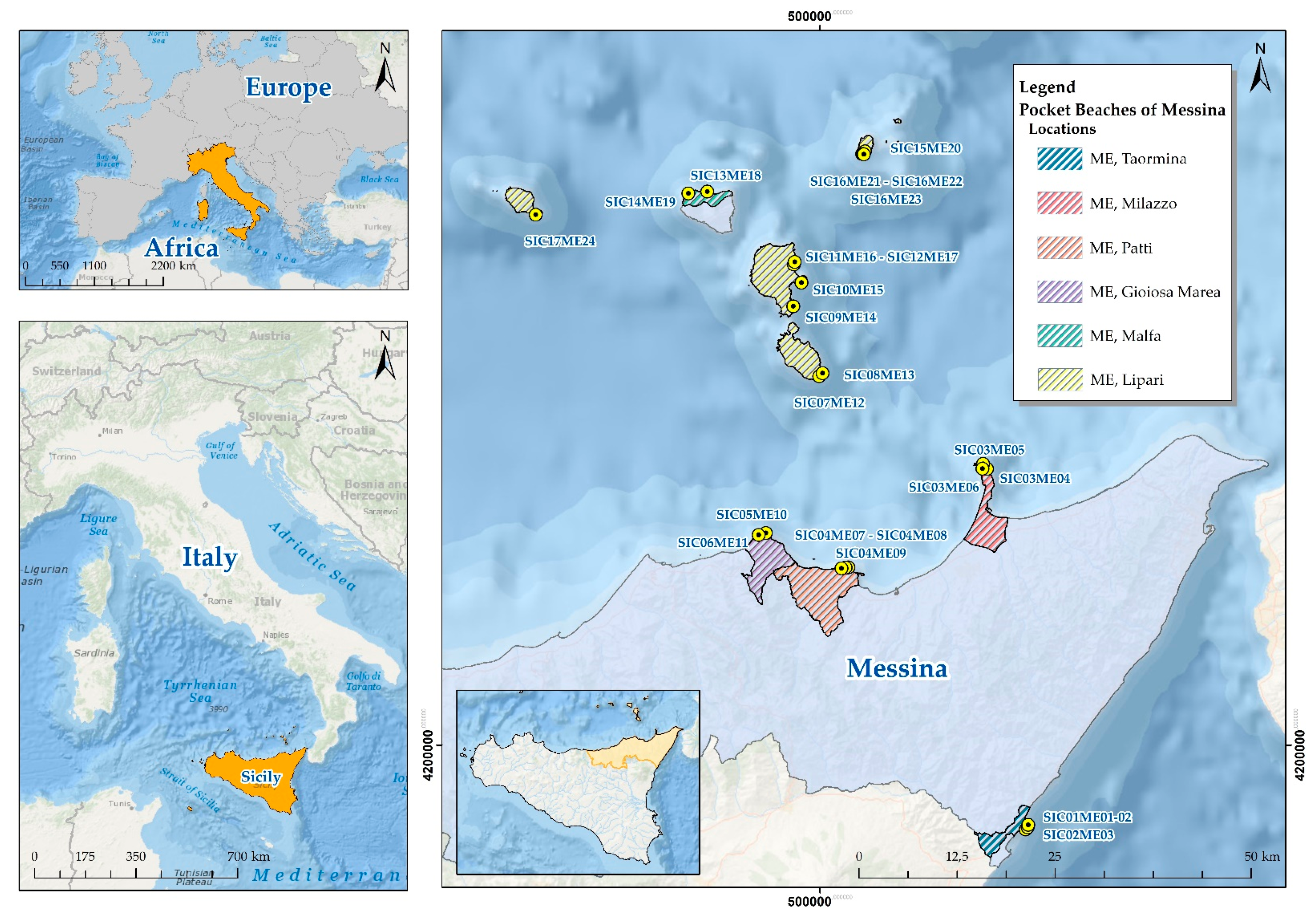
2.1. Area of Study
2.2. Data
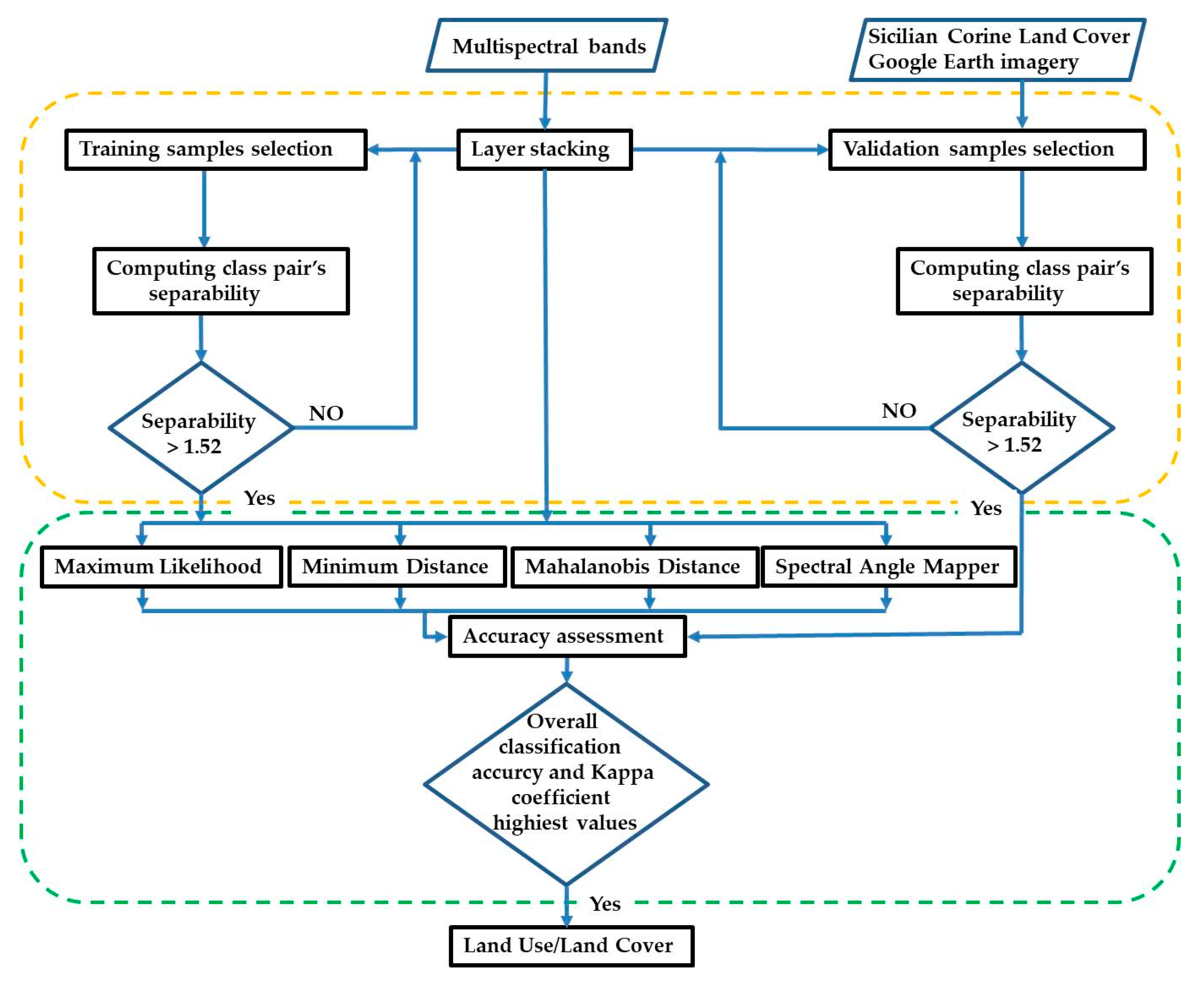
2.3. Methodology for Data Processing
2.4. Training and Validation Samples Collection
2.5. Class Pair Separability (Jeffries–Matusita or Transformed Divergence)
2.6. Brief Description of the Proposed Image Classification Algorithms
2.6.1. Maximum Likelihood Classification
2.6.2. Minimum Distance Classification
2.6.3. Mahalanobis Distance
2.6.4. Spectral Angle Mapper
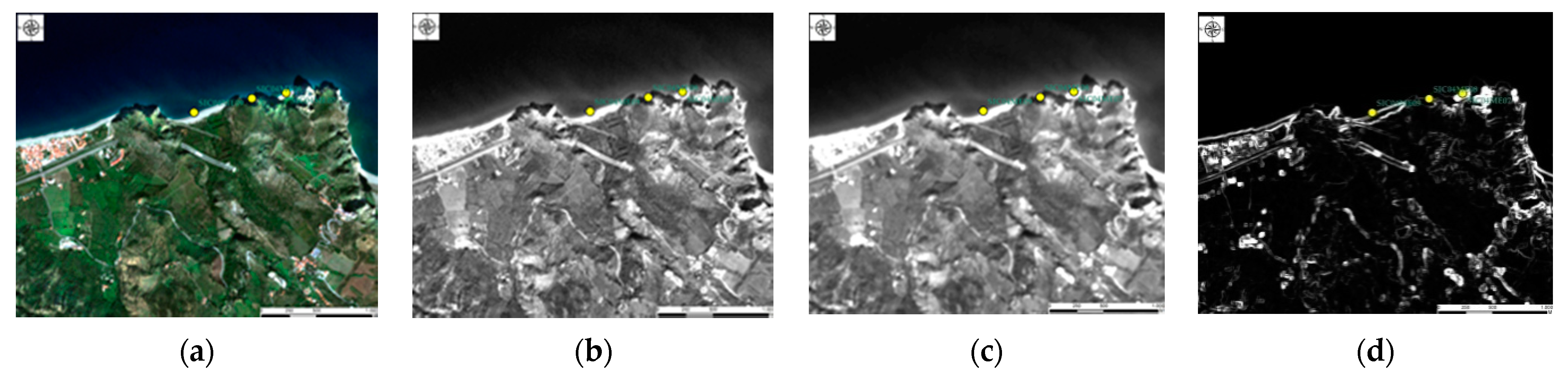
2.7. Occurrence-Based Filtering
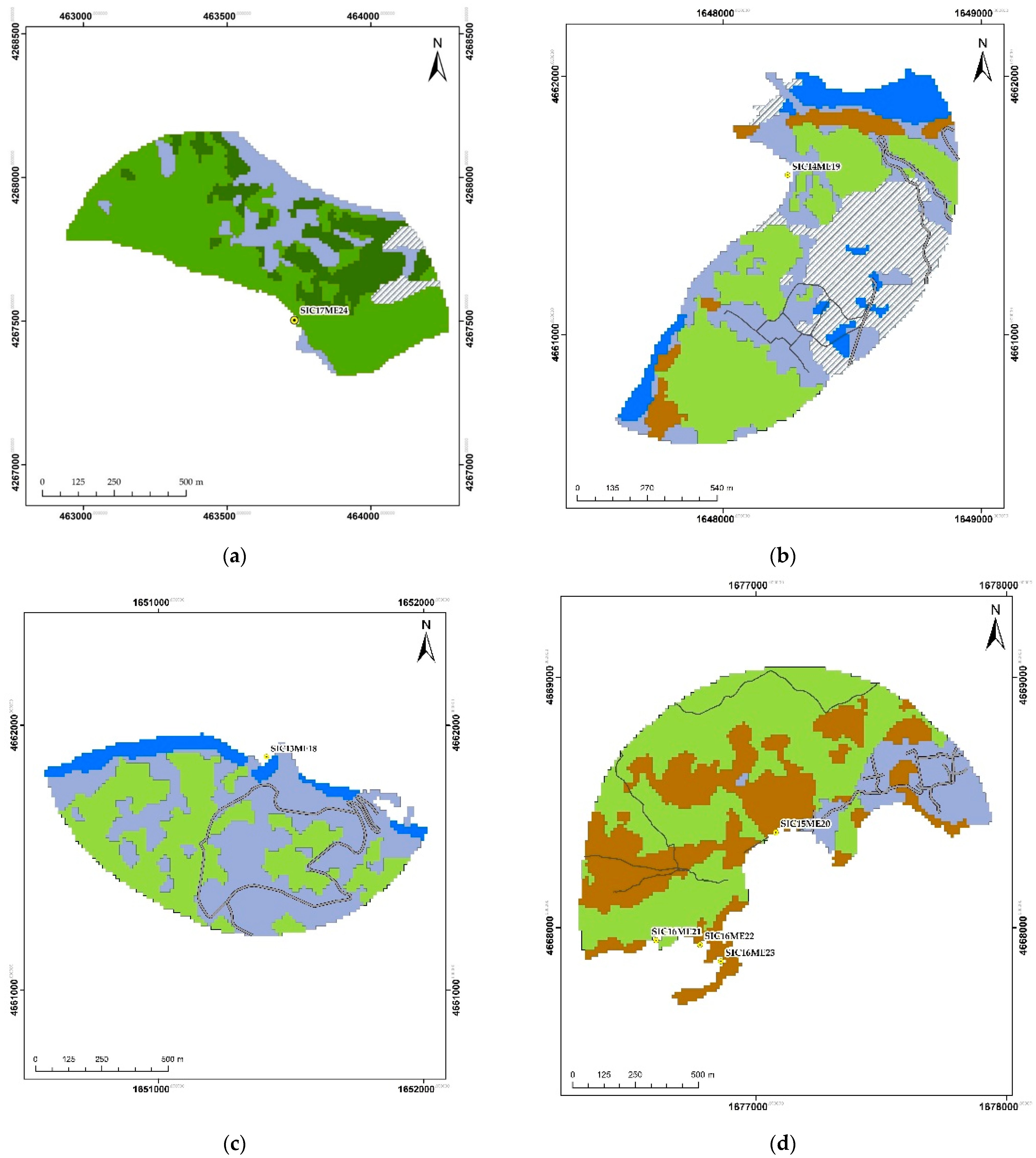
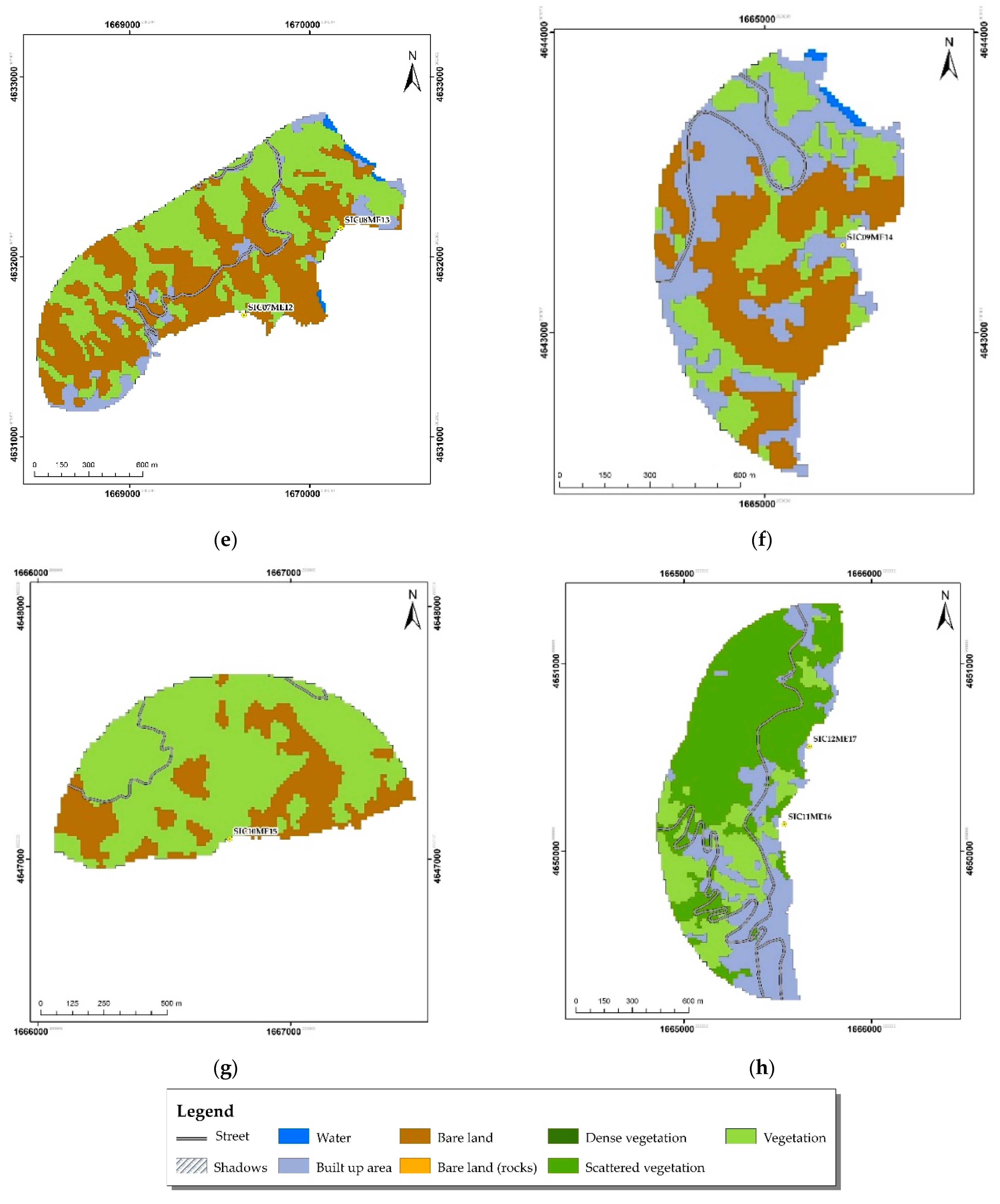
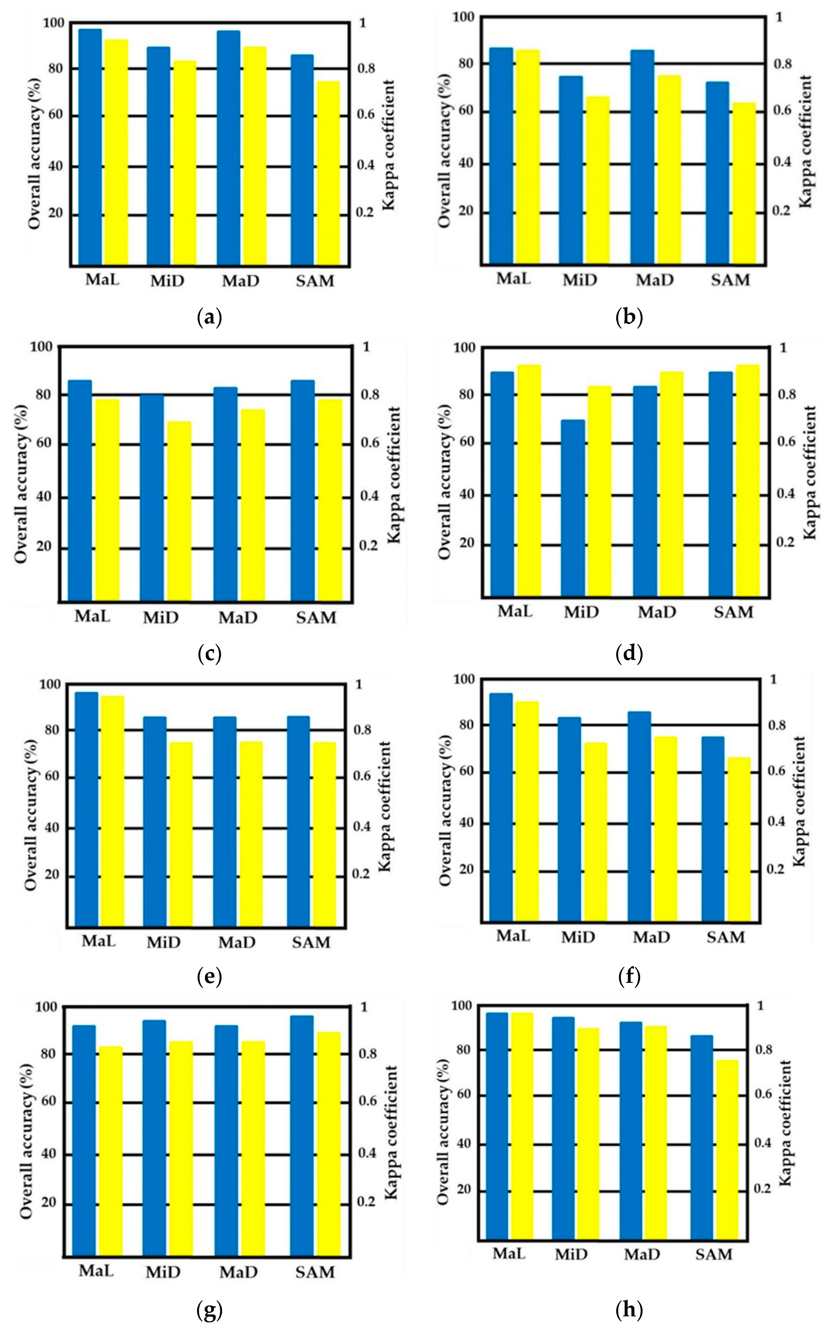
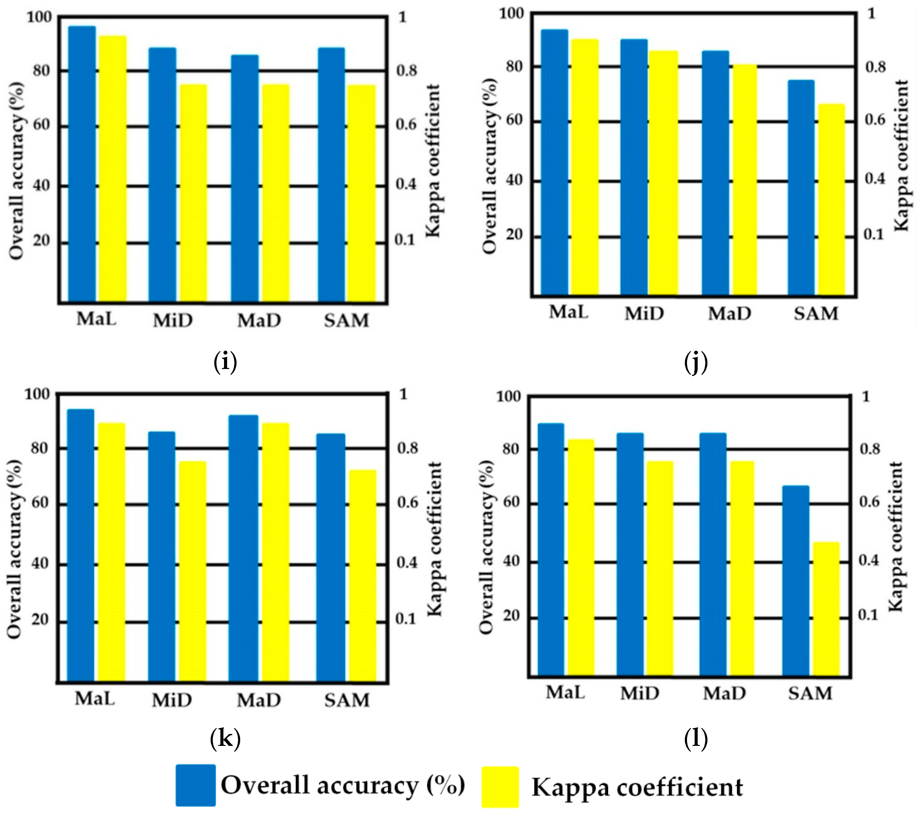
3. Results
4. Discussion
4.1. Effect of Class Combination and Topography on Classification Accuracy and Precision
4.2. Limitation and Suitability of Conducting Supervised Classification Procedures
5. Conclusions
Supplementary Materials
Author Contributions
Funding
Data Availability Statement
Conflicts of Interest
References
- Dehouck, A.; Dupuis, H.; Sénéchal, N. Pocket beach hydrodynamics: The example of four macrotidal beaches, Brittany, France. Mar. Geol. 2009, 266, 1–17. [Google Scholar] [CrossRef]
- Pranzini, E.; Rosas, V.; Jackson, N.L.; Nordstrom, K.F. Beach changes from sediment delivered by streams to pocket beaches during a major flood. Geomorphology 2013, 199, 36–47. [Google Scholar] [CrossRef]
- Pocket Beach Management and Remote Surveillance System (BESS). Available online: http://bess.pa.ingv.it/?lang=it (accessed on 7 August 2020).
- Pranzini, E.; Rosas, V. Pocket beach response to high magnitude–low frequency floods (Elba Island, Italy). J. Coast. Res. 2009, 50, 969–977. [Google Scholar]
- Randazzo, G.; Lanza, S. Regional Plan against Coastal Erosion: A Conceptual Model for Sicily. Land 2020, 9, 307. [Google Scholar] [CrossRef]
- Petrişor, A.-I.; Hamma, W.; Nguyen, H.; Randazzo, G.; Muzirafuti, A.; Stan, M.-I.; Tran, V.; Aştefănoaiei, R.; Bui, Q.-T.; Vintilă, D.-F.; et al. Degradation of Coastlines under the Pressure of Urbanization and Tourism: Evidence on the Change of Land Systems from Europe, Asia and Africa. Land 2020, 9, 275. [Google Scholar] [CrossRef]
- Costa, H.; Benevides, P.; Marcelino, F.; Caetano, M. Introducing Automatic Satellite Image Processing into Land Cover Mapping by Photo-Interpretation of Airborne Data. ISPRS Arch. 2020, XLII-3/W11, 29–34. [Google Scholar] [CrossRef] [Green Version]
- Risandi, J.; Hansen, J.E.; Lowe, R.; Rijnsdorp, D.P. Shoreline Variability at a Reef-Fringed Pocket Beach. Front. Mar. Sci. 2020, 7, 7. [Google Scholar] [CrossRef]
- Risandi, J.; Rijnsdorp, D.P.; Hansen, J.E.; Lowe, R.J. Hydrodynamic Modeling of a Reef-Fringed Pocket Beach Using a Phase-Resolved Non-Hydrostatic Model. J. Mar. Sci. Eng. 2020, 8, 877. [Google Scholar] [CrossRef]
- Colaço, G.; Violante-Carvalho, N.; Arruda, W.Z.; D’Avila, V.; Vilhena, H.; Filippo, A.; Candella, R. Mid-long term characterisation and short term modelling of a semi-protected pocket sandy beach in the Southern Coast of Brazil. Reg. Stud. Mar. Sci. 2021, 41, 101593. [Google Scholar] [CrossRef]
- Bowman, D.; Guillen, J.; López, L.; Pellegrino, V. Planview Geometry and morphological characteristics of pocket beaches on the Catalan coast (Spain). Geomorphology 2009, 108, 191–199. [Google Scholar] [CrossRef]
- Bowman, D.; Rosas, V.; Pranzini, E. Pocket beaches of Elba Island (Italy)—Planview geometry, Depth of closure and sediment dispersal. Estuar. Coast. Shelf Sci. 2014, 138, 37–46. [Google Scholar] [CrossRef]
- Hsu, J.R.-C.; Benedet, L.; Klein, A.H.F.; Raabe, A.L.A.; Tsai, C.-P.; Hsu, T.-W. Appreciation of Static Bay Beach Concept for Coastal Management and Protection. J. Coast. Res. 2008, 24, 198–215. [Google Scholar] [CrossRef]
- Cipriani, L.E.; Pranzini, E.; Rosas, V.; Wetzel, L. Landuse changes and erosion of pocket beaches in Elba Island (Tuscany, Italy). J. Coast. Res. 2011, SI64, 1774–1778. [Google Scholar]
- Del Grosso, G.; Pranzini, E. Pocket beach erosion: Golfo di Procchio (Isola d’Elba). Medcoast 2003, 64, 1559–1570. [Google Scholar]
- Mannori, S.; Pranzini, E. From agriculture to tourism: A cause of beach erosion. In Proceedings of the 1st International Conference on the Management of Coastal Recreational Resources (Malta), Valletta, Malta, 20–23 October 2004; Micallef, A., Vassallo, A., Eds.; University of Malta: Valletta, Malta, 2004; pp. 79–85. [Google Scholar]
- Mateo-Pérez, V.; Corral-Bobadilla, M.; Ortega-Fernández, F.; Vergara-González, E. Port Bathymetry Mapping Using Support Vector Machine Technique and Sentinel-2 Satellite Imagery. Remote. Sens. 2020, 12, 2069. [Google Scholar] [CrossRef]
- Randazzo, G.; Barreca, G.; Cascio, M.; Crupi, A.; Fontana, M.; Gregorio, F.; Lanza, S.; Muzirafuti, A. Analysis of Very High Spatial Resolution Images for Automatic Shoreline Extraction and Satellite-Derived Bathymetry Mapping. Geosciences 2020, 10, 172. [Google Scholar] [CrossRef]
- Mugo, R.; Waswa, R.; Nyaga, J.; Ndubi, A.; Adams, E.; Flores-Anderson, A. Quantifying Land Use Land Cover Changes in the Lake Victoria Basin Using Satellite Remote Sensing: The Trends and Drivers between 1985 and 2014. Remote Sens. 2020, 12, 2829. [Google Scholar] [CrossRef]
- Politi, E.; Paterson, S.K.; Scarrott, R.; Tuohy, E.; O’Mahony, C.; Cámaro-García, W.C. Earth observation applications for coastal sustainability: Potential and challenges for implementation. Anthr. Coasts 2019, 2, 306–329. [Google Scholar] [CrossRef] [Green Version]
- Zhang, A.; Sun, G.; Ma, P.; Jia, X.; Ren, J.; Huang, H.; Zhang, X. Coastal Wetland Mapping with Sentinel-2 MSI Imagery Based on Gravitational Optimized Multilayer Perceptron and Morphological Attribute Profiles. Remote Sens. 2019, 11, 952. [Google Scholar] [CrossRef] [Green Version]
- Feng, Q.; Yang, J.; Zhu, D.; Liu, J.; Guo, H.; Bayartungalag, B.; Li, B. Integrating Multitemporal Sentinel-1/2 Data for Coastal Land Cover Classification Using a Multibranch Convolutional Neural Network: A Case of the Yellow River Delta. Remote Sens. 2019, 11, 1006. [Google Scholar] [CrossRef] [Green Version]
- Forkuor, G.; Ullmann, T.; Griesbeck, M. Mapping and Monitoring Small-Scale Mining Activities in Ghana using Sentinel-1 Time Series (2015–2019). Remote. Sens. 2020, 12, 911. [Google Scholar] [CrossRef] [Green Version]
- Metcalfe, K.; Bréheret, N.; Chauvet, E.; Collins, T.; Curran, B.K.; Parnell, R.J.; Turner, R.A.; Witt, M.J.; Godley, B.J. Using satellite AIS to improve our understanding of shipping and fill gaps in ocean observation data to support marine spatial planning. J. Appl. Ecol. 2018, 55, 1834–1845. [Google Scholar] [CrossRef]
- Xi, Y.; Ji, L.; Geng, X. Pen Culture Detection Using Filter Tensor Analysis with Multi-Temporal Landsat Imagery. Remote. Sens. 2020, 12, 1018. [Google Scholar] [CrossRef] [Green Version]
- Stiller, D.; Ottinger, M.; Leinenkugel, P. Spatio-Temporal Patterns of Coastal Aquaculture Derived from Sentinel-1 Time Series Data and the Full Landsat Archive. Remote. Sens. 2019, 11, 1707. [Google Scholar] [CrossRef] [Green Version]
- Saitoh, S.-I.; Mugo, R.; Radiarta, I.N.; Asaga, S.; Takahashi, F.; Hirawake, T.; Ishikawa, Y.; Awaji, T.; In, T.; Shima, S. Some operational uses of satellite remote sensing and marine GIS for sustainable fisheries and aquaculture. ICES J. Mar. Sci. 2011, 68, 687–695. [Google Scholar] [CrossRef] [Green Version]
- Santamaria, C.; Alvarez, M.; Greidanus, H.; Syrris, V.; Soille, P.; Argentieri, P. Mass Processing of Sentinel-1 Images for Maritime Surveillance. Remote. Sens. 2017, 9, 678. [Google Scholar] [CrossRef] [Green Version]
- De Sherbinin, A.; Levy, M.; Adamo, S.; MacManus, K.; Yetman, G.; Mara, V.; Razafindrazay, L.; Goodrich, B.; Srebotnjak, T.; Aichele, C. Migration and risk: Net migration in marginal ecosystems and hazardous areas. Environ. Res. Lett. 2012, 7, 045602. [Google Scholar] [CrossRef] [Green Version]
- Abdullah, A.Y.M.; Masrur, A.; Adnan, M.S.G.; Al Baky, A.; Hassan, Q.K.; Dewan, A. Spatio-temporal Patterns of Land Use/Land Cover Change in the Heterogeneous Coastal Region of Bangladesh between 1990 and 2017. Remote. Sens. 2019, 11, 790. [Google Scholar] [CrossRef] [Green Version]
- Islam, M.R.; Miah, M.G.; Inoue, Y. Analysis of Land use and Land Cover Changes in the Coastal Area of Bangladesh using Landsat Imagery. Land Degrad. Dev. 2016, 27, 899–909. [Google Scholar] [CrossRef]
- ENVI Maximum Likelihood Classification Method Descriptions. Available online: https://www.l3harrisgeospatial.com/docs/MaximumLikelihood.html (accessed on 29 January 2021).
- ENVI Minimum Distance Classification Method Descriptions. Available online: https://www.l3harrisgeospatial.com/docs/minimumdistance.html (accessed on 29 January 2021).
- ENVI Mahalanobis Distance Classification Method Descriptions. Available online: https://www.l3harrisgeospatial.com/docs/Mahalanobis.html (accessed on 29 January 2021).
- ENVI Spectral Angle Mapper Classification Method Descriptions. Available online: https://www.l3harrisgeospatial.com/docs/SpectralAngleMapper.html (accessed on 29 January 2021).
- Regione Siciliana—SITR. Digital Orthophotos, with Pixels of 25 cm. The Data Is Published Using a Cache System in Web Mercator Coordinates. Available online: http://www.sitr.regione.sicilia.it/geoportale/it/Metadata/Details/120 (accessed on 30 June 2020).
- BESS WebGIS Designed for Monitoring and Maintenance of the Pocket Beaches of Sicily and Malta. Available online: http://51.38.247.246/mylizmap/lizmap/www/index.php/view/map/?repository=bess&project=bess (accessed on 29 March 2021).
- Sicilian Population Density. Available online: https://ugeo.urbistat.com/AdminStat/en/it/demografia/dati-sintesi/sicilia/19/2 (accessed on 1 November 2020).
- Increasing Number of Tourists in Sicily. Available online: https://qds.it/in-sicilia-cresce-il-numero-di-turisti-stranieri-22/ (accessed on 1 November 2020).
- National Demographic Data 2020 Obtained from the National Institute of Statistics. Available online: http://www.regioni.it/newsletter/n-3880/del-13-07-2020/istat-diminuiscono-le-nascite-e-anche-gli-stranieri-21451/ (accessed on 9 November 2020).
- Arsanjani, J.J.; Mooney, P.; Zipf, A.; Schauss, A. Quality Assessment of the Contributed Land Use Information from OpenStreetMap Versus Authoritative Datasets. In Lecture Notes in Geoinformation and Cartography; Springer Science and Business Media LLC: Heidelberg/Berlin, Germany, 2015; pp. 37–58. [Google Scholar]
- Viana, C.M.; Encalada, L.; Rocha, J. The value of OpenStreetMap Historical Contributions as a Source of Sampling Data for Multi-temporal Land Use/Cover Maps. ISPRS Int. J. Geo-Inf. 2019, 8, 116. [Google Scholar] [CrossRef] [Green Version]
- ENVI Software 5.5 Release Notes. Available online: https://www.l3harrisgeospatial.com/Support/Self-Help-Tools/Help-Articles/Help-Articles-Detail/ArtMID/10220/ArticleID/22334/ENVI-55-Release-Notes (accessed on 29 January 2021).
- ENVI Occurrence-Based Filtering Tools Descriptions. Available online: https://www.l3harrisgeospatial.com/docs/texturefilters.html (accessed on 29 January 2021).
- Sicilian Land Use Map According to Corine Land Cover. Available online: http://www.sitr.regione.sicilia.it/geoportale/it/Metadata/Details/337 (accessed on 30 June 2020).
- Hütt, C.; Koppe, W.; Miao, Y.; Bareth, G. Best Accuracy Land Use/Land Cover (LULC) Classification to Derive Crop Types Using Multitemporal, Multisensor, and Multi-Polarization SAR Satellite Images. Remote Sens. 2016, 8, 684. [Google Scholar] [CrossRef] [Green Version]
- Alonso-Sarria, F.; Valdivieso-Ros, C.; Gomariz-Castillo, F. Isolation Forests to Evaluate Class Separability and the Representativeness of Training and Validation Areas in Land Cover Classification. Remote Sens. 2019, 11, 3000. [Google Scholar] [CrossRef] [Green Version]
- Zhang, D.; Fang, S.; She, B.; Zhang, H.; Jin, N.; Xia, H.; Yang, Y.; Ding, Y. Winter Wheat Mapping Based on Sentinel-2 Data in Heterogeneous Planting Conditions. Remote Sens. 2019, 11, 2647. [Google Scholar] [CrossRef] [Green Version]
- Mohajane, M.; Essahlaoui, A.; Oudija, F.; El Hafyani, M.; El Hmaidi, A.; El Ouali, A.; Randazzo, G.; Teodoro, A.C. Land Use/Land Cover (LULC) Using Landsat Data Series (MSS, TM, ETM+ and OLI) in Azrou Forest, in the Central Middle Atlas of Morocco. Environments 2018, 5, 131. [Google Scholar] [CrossRef] [Green Version]
- Topaloğlu, H.R.; Sertel, E.; Musaoğlu, N. Assessment of classification accuracies of SENTINEL-2 and LANDSAT-8 data for land cover/use mapping. In International Archives of the Photogrammetry, Remote Sensing and Spatial Information Sciences; ISPRS: Prague, Czech Republic, 2016; Volume XLI-B8, pp. 1055–1059. [Google Scholar]
- Ahmad, A.; Quegan, S. Analysis of maximum likelihood classification on multispectral data. Appl. Math. Sci. 2012, 6, 6425–6436. [Google Scholar]
- Eskandari, S.; Jaafari, M.R.; Oliva, P.; Ghorbanzadeh, O.; Blaschke, T. Mapping Land Cover and Tree Canopy Cover in Zagros Forests of Iran: Application of Sentinel-2, Google Earth, and Field Data. Remote Sens. 2020, 12, 1912. [Google Scholar] [CrossRef]
- Chuvieco, E. Fundamentals of Satellite Remote Sensing: An Environmental Approach, 2nd ed.; CRC Press, Taylor & Francis Group: Boca Raton, FL, USA, 2016; 468p. [Google Scholar]
- Petropoulos, G.P.; Vadrevu, K.P.; Xanthopoulos, G.; Karantounias, G.; Scholze, M. A Comparison of Spectral Angle Mapper and Artificial Neural Network Classifiers Combined with Landsat TM Imagery Analysis for Obtaining Burnt Area Mapping. Sensors 2010, 10, 1967–1985. [Google Scholar] [CrossRef] [Green Version]
- Talukdar, S.; Singha, P.; Mahato, S.; Shahfahad; Pal, S.; Liou, Y.-A.; Rahman, A. Land-Use Land-Cover Classification by Machine Learning Classifiers for Satellite Observations—A Review. Remote Sens. 2020, 12, 1135. [Google Scholar] [CrossRef] [Green Version]
- Warner, T. Kernel-based texture in remote sensing image classification. Geogr. Compass 2011, 5, 781–798. [Google Scholar] [CrossRef]
- Haralick, R.M.; Shanmugan, K.; Dinstein, I. Texture features for image classification. IEEE Trans. Syst. Man Cybern. 1973, 3, 610–621. [Google Scholar] [CrossRef] [Green Version]
- Phiri, D.; Simwanda, M.; Salekin, S.; Nyirenda, V.R.; Murayama, Y.; Ranagalage, M. Sentinel-2 Data for Land Cover/Use Mapping: A Review. Remote Sens. 2020, 12, 2291. [Google Scholar] [CrossRef]
- Xu, R.; Liu, J.; Xu, J. Extraction of High-Precision Urban Impervious Surfaces from Sentinel-2 Multispectral Imagery via Modified Linear Spectral Mixture Analysis. Sensors 2018, 18, 2873. [Google Scholar] [CrossRef] [Green Version]


| Municipalities | Population in 2001 | Population in 2006 | Population in 2010 | Population in 2013 | Population in 2016 | Population in 2019 | Area (km2) |
|---|---|---|---|---|---|---|---|
| Gioiosa Marea | 7229 | 7198 | 7209 | 7198 | 7014 | 6880 | 26.48 |
| Taormina | 10,778 | 11,026 | 11,076 | 11,050 | 10,909 | 10,844 | 13.13 |
| Milazzo | 32,083 | 32,590 | 32,601 | 31,882 | 31,473 | 30,860 | 24.7 |
| Lipari | 10,556 | 10,894 | 11,386 | 12,500 | 12,753 | 12,836 | 89.71 |
| Malfa | 847 | 872 | 943 | 996 | 956 | 987 | 8.73 |
| Patti | 13,108 | 13,391 | 13,611 | 13,420 | 13,347 | 13,066 | 50.07 |
| Municipalities | Sentinel-2 Tiling Grid ID | Cloud Cover (%) |
|---|---|---|
| Gioiosa Marea, Lipari, Patti, Malfa | 33SVC | 0.43 |
| Taormina | 33SWB | 1.65 |
| Milazzo | 33SWC | 1.88 |
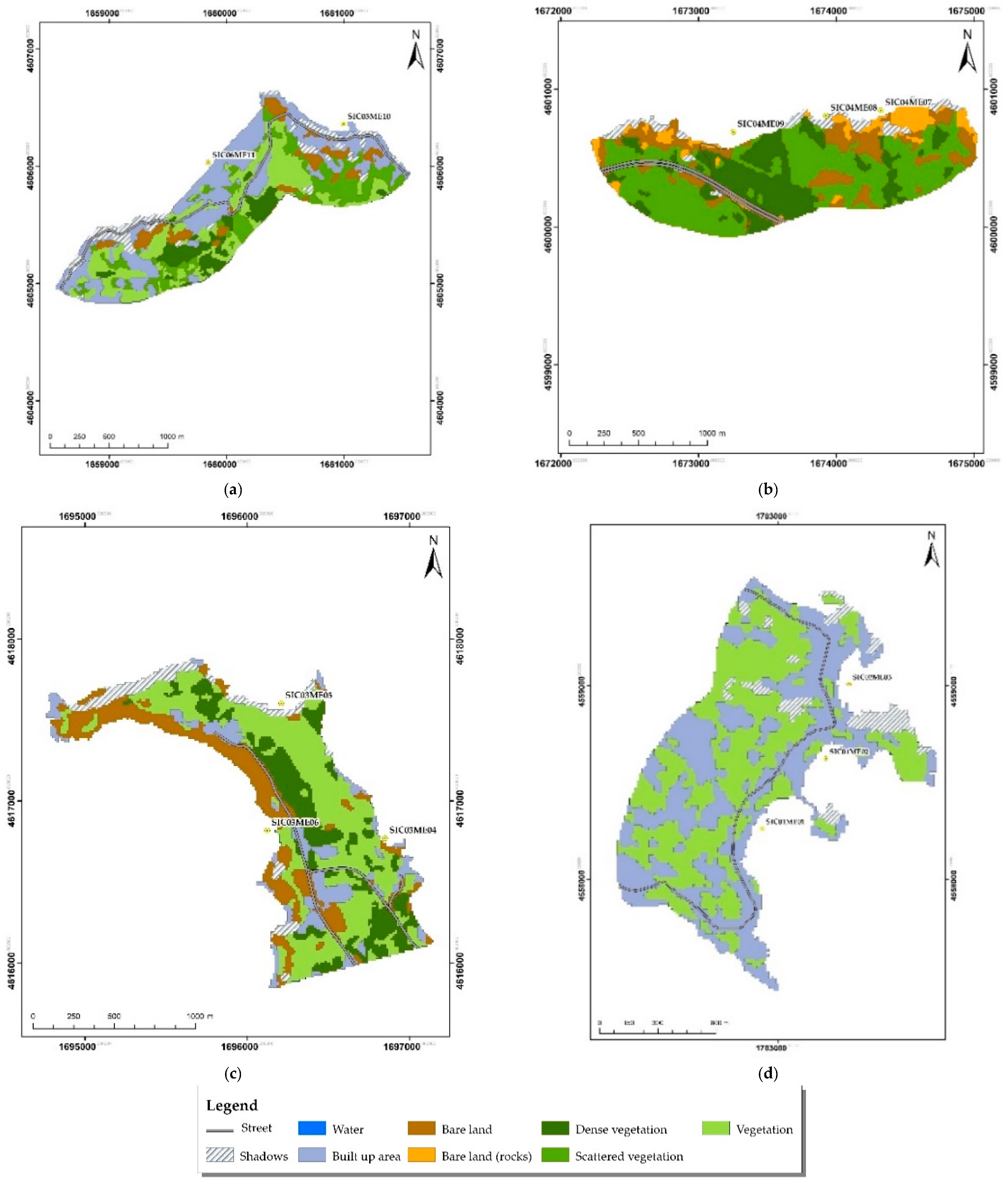
| Classes | Description |
|---|---|
| Shadows | Missing data |
| Built-up | Residential buildings and asphalt surfaces |
| Scattered vegetation | Sparse vegetation with 50% grassland covering surface |
| Vegetation | Vegetated arable lands or heterogeneous agricultural areas |
| Dense vegetation | Permanent crops, plantation trees, natural or semi-natural forest |
| Bare land | Nonvegetated agricultural and nonagricultural areas |
| Bare land (rocks) | Rocky outcroppings |
| Water | Seawater and swimming pools |
| Name of the Beaches | Municipality/Island | Codes of the Beaches | Coordinates (Decimal Degrees) | |
|---|---|---|---|---|
| Latitudes | Longitudes | |||
| South Isola Bella | Taormina | SIC01ME01 | 37.850035 | 15.297601 |
| North Isola Bella | Taormina | SIC01ME02 | 37.852593 | 15.300546 |
| Mazzarò | Taormina | SIC02ME03 | 37.855315 | 15.301613 |
| East Milazzo | Milazzo | SIC03ME04 | 38.263882 | 15.243056 |
| North Milazzo | Milazzo | SIC03ME05 | 38.269745 | 15.237303 |
| West Milazzo | Milazzo | SIC03ME06 | 38.264215 | 15.236534 |
| East Tindari | Patti | SIC04ME07 | 38.151473 | 15.040707 |
| Central Tindari | Patti | SIC04ME08 | 38.151205 | 15.037139 |
| West Tindari | Patti | SIC04ME09 | 38.150371 | 15.03108 |
| East Capo Calavà | Gioiosa Marea | SIC05ME10 | 38.190424 | 14.920996 |
| West Capo Calavà | Gioiosa Marea | SIC06ME11 | 38.188102 | 14.910634 |
| Punta dell’Asino | Lipari/Vulcano | SIC07ME12 | 38.370453 | 14.998676 |
| Punta Bandiera | Lipari/Vulcano | SIC08ME13 | 38.373471 | 15.003052 |
| La Forbice | Lipari/Lipari | SIC09ME14 | 38.450786 | 14.960705 |
| Pignataro di Fuori | Lipari/Lipari | SIC10ME15 | 38.477989 | 14.972756 |
| Sabbie Bianche | Lipari/Lipari | SIC11ME16 | 38.498898 | 14.961744 |
| Lido Blu | Lipari/Lipari | SIC12ME17 | 38.501816 | 14.962953 |
| Punta Scario | Malfa/Salina | SIC13ME18 | 38.582392 | 14.834378 |
| Pollara | Malfa/Salina | SIC14ME19 | 38.580203 | 14.807179 |
| Zimmaro | Lipari/Panarea | SIC15ME20 | 38.628785 | 15.065786 |
| West Preistorico | Lipari/Panarea | SIC16ME21 | 38.625762 | 15.061491 |
| Central Preistorico | Lipari/Panarea | SIC16ME22 | 38.62564 | 15.063061 |
| East Preistorico | Lipari/Panarea | SIC16ME23 | 38.625176 | 15.063807 |
| Le Punte | Lipari/Filicudi | SIC17ME24 | 38.555222 | 14.58378 |
| Codes of the PBs | Classes | Area | Producer’s Accuracy (%) | User’s Accuracy (%) | Overall Classification Accuracy (%) | Kappa Coefficient | |
|---|---|---|---|---|---|---|---|
| m2 | (%) | ||||||
| SIC01ME01, SIC01ME02, SIC02ME03 | Shadows | 53,700 | 6.05 | 100 | 27.78 | 96.98 | 0.93 |
| Built-up | 426,100 | 48 | 100 | 98.62 | |||
| Vegetation | 407,800 | 45.94 | 95.70 | 100 | |||
| SIC03ME04, SIC03ME05, SIC03ME06 | Shadows | 61,500 | 6.27 | 100 | 76.47 | 89.07 | 0.85 |
| Built-up | 119,600 | 12.21 | 86.36 | 96.94 | |||
| Vegetation | 399,700 | 40.8 | 96.35 | 84.62 | |||
| Dense vegetation | 189,400 | 19.33 | 81.48 | 97.06 | |||
| Bare land | 209,300 | 21.36 | 95.12 | 75.00 | |||
| SIC04ME07, SIC04ME08, SIC04ME09 | Shadows | 59,600 | 5.45 | 56.1 | 96.72 | 87.06 | 0.79 |
| Scattered vegetation | 496,200 | 45.42 | 91.01 | 93.08 | |||
| Dense vegetation | 256,600 | 23.49 | 99.32 | 82.21 | |||
| Bare land | 184,500 | 16.89 | 68.25 | 89.84 | |||
| Bare land (rocks) | 95,400 | 8.73 | 83.56 | 46.56 | |||
| SIC05ME10, SIC06ME11 | Shadows | 94,100 | 7.37 | 98.08 | 100 | 89.63 | 0.86 |
| Built-up | 428,800 | 33.62 | 92.24 | 99.55 | |||
| Scattered vegetation | 214,200 | 16.79 | 74.71 | 65.33 | |||
| Vegetation | 322,000 | 25.24 | 88.10 | 81.70 | |||
| Dense vegetation | 112,700 | 8.83 | 89.39 | 100 | |||
| Bare land | 103,500 | 8.11 | 100 | 98.54 | |||
| SIC09ME14 | Built-up | 167,100 | 36.64 | 92.83 | 89.80 | 92.63 | 0.89 |
| Vegetation | 111,600 | 24.47 | 95.73 | 94.58 | |||
| Bare land | 173,500 | 38.04 | 94.32 | 93.79 | |||
| Water | 3800 | 0.83 | 67.65 | 100 | |||
| SIC10ME15 | Vegetation | 333,800 | 71.93 | 100 | 83.55 | 94.81 | 0.87 |
| Bare land | 130,200 | 28.06 | 92.96 | 100 | |||
| SIC11ME16, SIC12ME17 | Built-up | 7088 | 26.77 | 97.74 | 98.30 | 98.76 | 0.97 |
| Scattered vegetation | 424,400 | 53.44 | 99.15 | 99.09 | |||
| Vegetation | 157,100 | 19.78 | 100 | 97.17 | |||
| SIC07ME12, SIC08ME1 | Built-up | 82,400 | 8.58 | 82.83 | 93.18 | 96.08 | 0.93 |
| Vegetation | 421,900 | 43.93 | 97.51 | 99.49 | |||
| Bare land | 448,400 | 46.69 | 100 | 94.67 | |||
| Water | 7600 | 0.79 | 66.67 | 100 | |||
| SIC15ME20, SIC16ME21, SIC16ME22 | Built-up | 83,500 | 12.44 | 98.42 | 95.04 | 92.80 | 0.88 |
| Vegetation | 350,200 | 52.21 | 98.31 | 84.30 | |||
| Bare land | 237,000 | 35.33 | 86.44 | 99.14 | |||
| SIC17ME24 | Shadows | 19,800 | 3.47 | 98.63 | 100 | 90.45 | 0.82 |
| Built-up | 99,000 | 17.35 | 94.59 | 100 | |||
| Scattered vegetation | 338,600 | 59.35 | 87.84 | 98.26 | |||
| Dense vegetation | 113,100 | 19.82 | 95.06 | 70 | |||
| SIC13ME18 | Built-up | 226,800 | 51.53 | 96.99 | 99.56 | 97.76 | 0.95 |
| Vegetation | 176,900 | 40.19 | 100 | 92 | |||
| Water | 36,400 | 8.27 | 97.97 | 99.32 | |||
| SIC14ME19 | Shadows | 153,400 | 23.92 | 97.40 | 100 | 94.89 | 0.92 |
| Built-up | 158,500 | 24.71 | 92.48 | 72.32 | |||
| Vegetation | 223,400 | 34.84 | 99.08 | 98.19 | |||
| Bare land | 38,700 | 6.03 | 63.43 | 96.52 | |||
| Water | 67,200 | 10.48 | 100 | 95.63 | |||
Publisher’s Note: MDPI stays neutral with regard to jurisdictional claims in published maps and institutional affiliations. |
© 2021 by the authors. Licensee MDPI, Basel, Switzerland. This article is an open access article distributed under the terms and conditions of the Creative Commons Attribution (CC BY) license (https://creativecommons.org/licenses/by/4.0/).
Share and Cite
Randazzo, G.; Cascio, M.; Fontana, M.; Gregorio, F.; Lanza, S.; Muzirafuti, A. Mapping of Sicilian Pocket Beaches Land Use/Land Cover with Sentinel-2 Imagery: A Case Study of Messina Province. Land 2021, 10, 678. https://0-doi-org.brum.beds.ac.uk/10.3390/land10070678
Randazzo G, Cascio M, Fontana M, Gregorio F, Lanza S, Muzirafuti A. Mapping of Sicilian Pocket Beaches Land Use/Land Cover with Sentinel-2 Imagery: A Case Study of Messina Province. Land. 2021; 10(7):678. https://0-doi-org.brum.beds.ac.uk/10.3390/land10070678
Chicago/Turabian StyleRandazzo, Giovanni, Maria Cascio, Marco Fontana, Francesco Gregorio, Stefania Lanza, and Anselme Muzirafuti. 2021. "Mapping of Sicilian Pocket Beaches Land Use/Land Cover with Sentinel-2 Imagery: A Case Study of Messina Province" Land 10, no. 7: 678. https://0-doi-org.brum.beds.ac.uk/10.3390/land10070678