
Exploring Spatio-Temporal Patterns of Urban Village Redevelopment: The Case of Shenzhen, China

1
Department of Construction Management and Real Estate, Shenzhen University, Shenzhen 518052, China
2
School of Civil Engineering, Nanjing Forestry University, Nanjing 210037, China
*
Author to whom correspondence should be addressed.
Land 2021, 10(9), 976; https://0-doi-org.brum.beds.ac.uk/10.3390/land10090976
Submission received: 16 August 2021
/
Revised: 5 September 2021
/
Accepted: 14 September 2021
/
Published: 16 September 2021
(This article belongs to the Section Land Planning and Landscape Architecture)
Abstract
:The redevelopment of urban villages is a prominent part of urban renewal in China, which has attracted much attention from the academic community. However, the understanding of when and where the redevelopment of urban villages occurs is still limited partly because of the lack of empirical analysis. Through exploratory spatial data and overlay analyses, this study examines the spatio-temporal distribution characteristics based on data from 277 urban village redevelopment projects in Shenzhen, China, between 2010 and 2018. Results demonstrate that the redevelopment of urban villages occurs in central and suburban areas but rarely occurs in the periphery of the city. The overall spatial distribution is spatially clustered, having become increasingly significant from 2010 to 2018. In the beginning, the redevelopment of urban villages was dispersed in diverse areas and partly expanded into adjacent neighbourhoods. A majority of redevelopment took place in areas near the planning urban centres and the planning subway stations, which are almost in Density Zones I–III. The findings of this study contribute to new spatio-temporal perspectives in the global process mechanism of urban village redevelopment and call for special attention to the significant influences of state intervention, which is an informative reference for future sustainable urban development.
1. Introduction
China’s rapid urbanisation has limited the sustainable development of some cities because of the increasing scarcity of free developable land (renamed ‘greenfields’), particularly in densely populated megacities. According to the seventh national census, the national population reached 1,411,778,724 by 2020, among which the urban population was over 900 million. China’s urbanization rate has reached 63.89%. According to UN [1], this rate will continue to increase in the coming years and reach 70% by 2030. In the process of rapid urbanisation, most of the formal land has developed into new urban areas. A large area of urban land is controlled by local village collectives and has undergone informal development located in a variety of areas in the city, or so-called urban villages. The presence of urban villages has caused a variety of negative outcomes, such as inefficient land use [2], suboptimal surroundings [3,4,5], and limited land property rights [6]. Against this background, demolishing and rebuilding urban villages has become more common in past decades, which is one of the effective ways to solve these problems. By reshaping the intra-urban space of cities, the redevelopment of urban villages makes a great contribution to improve the living environment for urban migrants [7,8], provide more developable land for sustainable urban development [9], and attract further investment to sustain economic growth [10]. Therefore, as a unique regeneration pattern of urban renewal in China, the redevelopment of urban villages has greatly attracted the attention of society and academia.
Each urban village is unique in its locational attributes, and the redevelopment process will significantly impact neighbourhoods and their residents. Urban villages do not exist independently, but rather, they exist in a certain geographical location and time because of the interconnections between their location and social and ecological development [11]. Similarly, the redevelopment of the urban village is a product of the vagaries of space and time. The developers’ preference for the location selection of redeveloped projects allows the land redevelopment to have certain commonality and regularity in spatial distribution characteristics and form a unique spatial pattern [12]. The spatio-temporal properties of urban village redevelopment reflect the actual development characteristics. Such a spatial reshaping process has a wide range of impacts on the urban environment and numerous people, such as a large scale displacement of migrants [13,14] and negative impacts on various social groups [15,16]. Local policymakers and citizens should better determine the spatial issues in the urban village redevelopment process and prepare themselves to address problems.
Furthermore, although the redevelopment of urban villages can dramatically increase the development potentials of neighbourhoods, the multiplicity of these sites requires considerable efforts to complete their redevelopment projects. In addition, the proper selection of good sites is a prerequisite to allocate the limited financial resources efficiently. The exploration and analysis of the spatio-temporal pattern and potential determinants for urban village redevelopment can help investors and decision-makers select the most advantageous sites for successful redevelopment. Therefore, the urban village redevelopment should be analysed in its spatio-temporal context. As a land redevelopment activity, the spatial distribution and temporal change of urban village redevelopment need further study.
Over the past two decades, studies on urban village redevelopment evaluated the role and relations of different stakeholders [17,18], investigated dissimilar types of governance modes [17,19], examined the socio-economic outcomes of urban village redevelopment [15,20], and proposed strategies for better redevelopment [21,22]. Previous studies have laid a solid basis for a better understanding of the process of individual redevelopment cases. However, few studies conducted a rigorous spatial-statistical analysis of comprehensive data to explore the process of urban village redevelopment within a metropolitan area. Where and when urban village redevelopment has taken place or is about to undergo an urban village redevelopment process is still unclear. Therefore, this study aims to examine the spatio-temporal characteristics of the urban village redevelopment based on scientific and systematic spatial methods. This study also explores the influencing factors of the spatial pattern from the perspective of government intervention on the basis of quantitative analysis of the spatial pattern of urban village redevelopment. The innovation of this study is that it explores the process of urban village redevelopment in a spatio-temporal perspective on the basis of a citywide empirical study. The results of this research are critical to a deeper understanding of when and where the urban village redevelopment occurs at the city level, providing a reference for city decision-makers to issue renewal policies and city planning to guide land redevelopment activities. The redevelopment experience in Shenzhen, which is a pioneer city in the promulgation of urban renewal legislation, can provide more informative references in policies and practices for other Chinese cities. From a broader international perspective, the study of urban village redevelopment can provide richer local experience and contributions to global land redevelopment research.
The remainder of this paper is organised as follows: Section 2 reviews research on land redevelopment in a spatio-temporal context. Section 3 introduces the background of Shenzhen and discusses the relevant state intervention that likely affects the location choice of redevelopment projects. Section 4 presents the data and research methods. Section 5 provides the empirical results. Finally, Section 6 provides a conclusion of all findings and discussion for future studies.
2. Literature Review
In addition to the complex processes involving urban space rebuilding [2], land ownership transformation [9], land value increment [23], and space benefits redistribution [17], urban village redevelopment is an essential urban land redevelopment activity. Marxist geographer Neil Smith [24] presented the rent gap theory to explain the process of market-led land redevelopment. The land rent gap refers to the difference between a site’s actual value and its potential value at ‘best use’. This theory is a fundamental concept in rich studies on land redevelopment processes. According to the rent gap theory, land with better economic development near the city centre, commercial centre, and CBD is more likely to experience redevelopment because of the large rent gap [25,26]. Actually, the driving process of land redevelopment is complex, which is related to the local development context, the land system, and the social and economic conditions. Previous studies verified that the redevelopment potential of urban areas is highly related to their geographical location, which simultaneously reflects its policy, and economic and geographical conditions [27,28]. Hu [29] pointed out that the rent gap, representing the urban capital accumulation, is an essential factor in determining whether urban plots can be redeveloped. Redevelopment occurs when the land rent gap becomes large enough to provide ideal economic returns. Arguably, the redevelopment of urban villages is more likely to occur in areas with a large rent gap. However, in addition to geographical factors, property rights and urban planning parameters also have a significant impact on the redevelopment of urban villages [30].
Regarding the importance of location, numerous western studies on redevelopment focused on the spatial pattern and the influencing factor of teardowns (housing redevelopment) or brownfield redevelopment. A rich body of empirical research found that specific determinants influence land redevelopments, such as geographic location [31], structural attributes [32], social-economic characteristics [33], prior redevelopment activity, and demographic factors [31,32,33,34]. In terms of housing redevelopment, Helms [31] argued that housing redevelopment is faster in proximity to central business districts or transportation hubs. Based on the data from the Chicago suburbs, being located in high-quality school zones increases the chances of being redeveloped [26]. Housing that is smaller and older and close to public transportation and traditional village centres is more likely to be selected for major demolition [32,35]. With regard to brownfield redevelopment, urban sites located near airports, and at the centre or the inner part of municipalities and cities, are often better positioned for potential redevelopment [31,36].
Spatial patterns of land redevelopment at the urban level have not been adequately explored, except for [37], who examined the spatial clustering of teardowns in Chicago. McMillen [35] focused on eight Chicago suburbs within similarly high rates of redevelopment activity and socio-economic characteristics. Furthermore, Charles [26] provided a further understanding of the spatial pattern of teardowns in Chicago through a larger and more socio-economically varied research area. In analysing the location and scope of clusters, the socio-economic and demographic characteristics of the area determine the location of redevelopment clusters. In a study on housing redevelopment in suburban Chicago, Frantál et al. [37] found that redevelopment tends to begin in areas with high property values. Moreover, as housing prices rise rapidly, redevelopment expands to neighbouring areas with fewer properties, retracting again at decade’s end. Exploring the spatio-temporal patterns of redevelopment activities can provide a better understanding on urban change.
The role of state and district governments in land redevelopment has become increasingly important in recent decades. Specifically, the local governments intervene in the location selection of redevelopment projects by planning regulations, regional strategies, and political power distribution. Frantál et al. [37] proposed that redevelopment is related to local development potential, local occupiers’ demand for specific utilities, and planning regulations through ANOVA models, such as distance from main roads, the rate of local business activity, and the quality of local infrastructure. Based on the National Land Use Database of the UK, Longo and Campbell [38] argued that locally tailored policies have a greater impact on promoting brownfield redevelopment than regional or national strategies. Tureckova et al. [39] presented that brownfield ownership, size, and the distance between brownfield sites and cities of extended power are all relevant. The local governments play a crucial role in the process of land redevelopment. From a spatial and temporal perspective, studies of land redevelopment not only included an analysis of site-specific attributes but also addressed the contextual factors influencing at additional levels.
With a tremendous change from the planned economy to the market-led redevelopment of urban villages in China, urban capital accumulation and developers have made extraordinary contributions to redevelopment processes. Meanwhile, the Chinese government still plays an important role in stimulating and regulating the process [40]. With the development of the market economy and the reform of the urban land system, a prosperous land market has been formed in China [41]. The presence of the land rent gap has gradually become the main driving force of land redevelopment in the form of real estate development [29,30]. On the one hand, land redevelopment in China has gradually turned into a real estate development activity in which the market players independently participate in the pursuit of spatial benefits [18,42,43]. Areas with a large land rent gap are more likely to be redeveloped in a profit-oriented process of capital accumulation. On the other hand, in the intertwined planned and market economies, the national and local states also lead to the selection of redevelopment projects by regulating the approval system and setting urban planning targets [40,44,45]. When the market-oriented real estate development becomes the main form of land redevelopment, the role of governments gradually changes from ‘absolute control’ to ‘guidance and regulation’. Local governments affect the location selection of redevelopment projects through administrative tools, such as urban spatial planning, thereby influencing the spatial distribution [43,46]. As a particular form of land redevelopment in China, whether or not urban villages are chosen as redevelopment candidates also greatly depends on the developers and the local governments.
To date, studies on determinants of the redevelopment of urban villages have largely been qualitative, which are based on case studies with specific local contexts [47,48] and stakeholder surveys [49,50]. In recent years, several scholars started to explore the processes of urban land redevelopment based on quantitative methods [30,51]. For example, the spatial distribution and influencing factors in 44 industrial urban villages located in the Nanshan district of Shenzhen were analysed in a previous study [52]. Existing studies did not address how the redevelopment of the urban village changes spatially and temporally nor consider the proximity of redevelopments to one another in terms of spatial clustering. Wu et al. [53] suggested that informal land governance in urban villages originates from urban centres and then expands to the periphery. Thus, urban village redevelopment is more likely to be realised in a particular geographical location. However, few studies provided quantitative examinations. Moreover, in several previous studies on urban redevelopment in western countries, statistically significant spatial clustering has generally been observed, revealing that the redevelopment activities are more likely to take place in areas where renewal has already occurred [26,37,54]. Whether redevelopment of urban villages in China has a similar spatio-temporal pattern has not been systematically investigated.
3. Data and Methods
3.1. Study Area
Shenzhen is one of the most concerning special economic zones in southern China adjacent to Hong Kong (Figure 1). Belonging to the prime geographical location of the Pearl River Delta and the Guangdong–Hong Kong–Macao Greater Bay Area, Shenzhen has rapidly developed from a small fishing village to a first-tier city with strong social and economic productivity since the reform and opening up as well as the establishment of the Special Economic Zone. Particularly, Shenzhen comprises two different areas from the beginning of the urban development period, namely, the central and suburban areas. Luohu, Nanshan, Futian, and Yantian District are located in the central area. The other six districts (Bao’an, Guangming, Longhua, Longgang, Pingshan, and Dapeng New District) are concluded by the suburban area. However, the area of Shenzhen is only 1997.47 km² (Shenzhen Statistical Yearbook 2020), and of which, the buildable land is only 1004 km2, which is not conducive to maintaining such rapid growth. The city is meeting the challenge of sustainable urban development and economic growth. Against such background, urban renewal has become an imperative approach to supply developable land for sustainable development and economic growth since 2004.
Shenzhen has rich experience in urban renewal practice and tends to explore new institutional arrangements, which is of great research significance. The Shenzhen government made many attempts and explorations in urban renewal before 2010. The top–down institutional arrangements governed a majority of redevelopment projects at that time. However, the implementation efficiency of early urban renewal projects was undesirable because of the limitations of various factors. The possible reasons can be considered from two aspects. Firstly, several selected urban villages are not suitable for demolition and reconstruction in a short time. Secondly, the stage of promoting implementation has various limitations, such as cumbersome approval process [49], vague land rights [55,56], and unclear institutional norms [3]. The redevelopment in Shenzhen has entered a new period mainly characterised by the bottom-up and market-oriented pattern since 2010. To promote the process of urban renewal more efficiently, the local government introduced new policies and regulations in late 2009 and implemented them in early 2010. The urban renewal unit system has regulated the land redevelopment process in Shenzhen including several regulated stages, such as project planning, planning approval, and identification of implementation subjects and implementation stages. The new system follows the principle of ‘market operation and government guidance’ and readjusts the power relationship and responsibility assignment amongst different participants in the redevelopment process. This urban renewal framework grants market players more rights in the selection of renewal projects, making the establishment of urban renewal projects a bottom-up market-oriented behaviour. The urban redevelopment in Shenzhen has begun to move forward in the form of real estate development. Against this context, Shenzhen can be regarded as a pioneer city in the promulgation of land redevelopment legislation. The experience of land redevelopment in Shenzhen has brought about a critical influence on redevelopment implementation in other Chinese cities. Taking Shenzhen as a study area can present a wider understanding of land redevelopment in China, as well as provide rich empirical evidence for the theoretical study.
Developers play an important role in the redevelopment of urban villages, and local state intervention has a significant impact. To pursue the tremendous space benefits generated by large land rent gaps, the developers take on most of the hard works during redevelopment processes, such as investigating preliminary willingness, paying compensation, resettling the right holder, and obtaining the land transfer permits. The active participation of market forces promoted the redevelopment process and decided where the redevelopment candidate occurs to a great extent. Under the market-oriented context of urban renewal, the profitability of a redevelopment project concerned with the market subject is the main determinant of whether the urban village is chosen to be reconstructed. The construction volume ratio of the urban village redevelopment project is decided by urban policy and planning attributes, such as density zones, surrounding transportation facilities, land use type, and planning parameters. More specifically, the Planning Standards and Guidelines of Shenzhen divide the construction land into five density zones, which has a direct impact on the plot ratio of redevelopment projects in different areas. The 13th Five-Year Plan of Shenzhen Municipality has made comprehensive plans for urban construction and land use from 2016 to 2020, including planning rail routes, planning centres, and zoning of priority renewal areas. Based on the above attributes and regulations, the planning construction volume ratio for each redevelopment project can be calculated. Moreover, the difference in development plans and local conditions between the central and suburban areas in Shenzhen is also supposed to be considered [57].
3.2. Data
The data used in this study include all urban village redevelopment demolition and redevelopment projects approved in Shenzhen between 2010 and 2018. These data were obtained from the websites of the Municipal Bureau of Planning and Natural Resources of Shenzhen [58], and the City Renewal and Land Development Bureau of districts [59,60,61,62,63,64,65,66,67,68]. Under the institutional framework of the urban renewal unit system in Shenzhen, the spatial patterns of urban village redevelopment were investigated based on the approved urban renewal unit approvals of all urban village redevelopment projects.
For this study, the time period was initially identified according to the fact that it is a period of increasing urban redevelopment activity. Since 2010, relatively comprehensive information on redevelopment projects has become available to the public with the implementation of the urban renewal unit system. Since then, another redevelopment model called comprehensive improvement was utilised in existing urban villages in 2018. This model restricts a large-scale relocation but encourages the improvement of the existing environment through the construction of auxiliary facilities, change in building functions, and partial demolition. Moreover, this model is completely different from the existing redevelopment pattern and differs significantly in the selection of sites for redevelopment targets. Therefore, this study does not include projects accepted after 2018.
Parcel-level approval permit data of urban village redevelopment projects are used in this research, whose information on the location and extent and area of demolition were confirmed and publicised between 1 January 2010 and 31 December 2018. Other auxiliary data, including the geographic boundary of Shenzhen and administrative districts, were collected from Street Map, whereas the data of ecological control areas are from the Shenzhen Planning and Natural Resources Bureau. In addition, we obtained the data of subway lines and planning centres from the 13th Five-Year Plan of Shenzhen Municipality. The data for planning density zoning maps were obtained from the Planning Standards and Guidelines of Shenzhen. Through the geographic registration tool in ArcGIS and ArcScan tool, we added and visualised the spatial attributes in the original data, which turn the JPG or CAD data into a Shape form. Combining the multivariate information, the datasets in a Shape file and an Excel file are provided for the following analyses. After the above data processing, a total of 277 urban village redevelopment projects in 3402.4 ha areas were approved from 2010 to 2018 in Shenzhen. The data of existing/planning subway lines, planning urban centres, and density zones were turned into a Shape file, which can support the visualised and overlay analysis in ArcGIS.
3.3. Methods
This study examined the location and scope of spatial clustering of urban village redevelopment using the Exploratory Spatial Data Analytical (ESDA) technique, a king of data-driven analysis approaches based on spatial data amongst different geo-localised variables [69]. The ESDA has been applied in multiple studies in many fields, especially in the social sciences [70,71,72]. According to previous explorations, ESDA is a collection of methods that describe and visualize spatial effects, including spatial dependence and spatial heterogeneity [73]. This technique can help us better understand the spatial locations and interrelationships with other spatial units when the observations present spatial heterogeneity or are spatially autocorrelated. In conjunction with ArcGIS, ESDA can well reveal the spatio-temporal pattern through visual maps. This technique can help explore and visualise spatial distributions; identify atypical locations or spatial outliers, examine spatial association, clusters, or hot spots; and present a spatial pattern or another type of spatial heterogeneity [69,74,75].
Firstly, the visual exploratory data analysis technique was used to present the spatial distribution based on distribution maps, statistics, and tables. The distribution pattern of redevelopment sites in urban villages was analysed with two different levels, including a community level and a grid level (grid of 0.5 km × 0.5 km).
Secondly, the spatial autocorrelation was examined through Moran’s I and Getis-Ord , including the global and local spatial autocorrelations. The spatial autocorrelation reflects the degree to which a geographical phenomenon in a regional unit is related to the same phenomenon or attribute value in a neighbouring area. The global spatial autocorrelation describes the degree of correlation amongst spatial objects within the study area to indicate whether a significant spatial distribution pattern exists. The Global Moran’s I was applied to assess the degree and sign of global spatial autocorrelation. The Moran’ I index measures the clustering of data across the space based on the global mean of data points [76]. This approach considers spatial weights and therefore gives more reliable results from a spatial perspective. Amongst different spatial statistics approaches, the Global Moran’s I was commonly used in previous studies [26,37,77].
Global Moran’s I is calculated as follows:
where indicates the spatial weight between features i and j; and refer to the attribute value of locations i and j, respectively; means the average value; and n is the number of features in the dataset.
The Global Moran’s I values can range from −1 to +1. When the spatial correlation is positive, the spatial clusters of high/low values are clustered in the same area. When the spatial correlation is negative, the sites with high values are close to those with low values (and vice versa). If the result is 0, then no spatial autocorrelation exists.
Thirdly, the local indicators of spatial association (LISA) and the Getis-Ord index were measured to explore local spatial autocorrelation. LISA statistics include Local Moran’s I, Moran scatter plot, and cluster map [78]. The local Moran’s I is calculated to examine whether the spatial clustering is significant in local areas. The Moran scatter plot is provided to explore where the autocorrelation clustering occurs and to provide spatial agglomeration maps.
Local Moran’s I is calculated as follows:
The results for the local indicators of spatial autocorrelation are provided in the tables, showing High–High, Low–Low, Low–High, and High–Low clustering patterns. In addition, a map indicates the significance levels of the identified spatial clusters (i.e., 0.05, 0.01 and 0.001). This map provides a reliable source to identify local clusters reflecting positive or negative spatial autocorrelation and spatial outliers.
Getis-Ord measures the dissimilarities between juxtaposition data points based on the differences between neighbouring data points, reflecting the relative size of the value of different neighbourhoods. The local distribution of variables in cold and hot spots can be reflected. Hot spots occur in areas where statistics are more concentrated than surrounding areas.
Getis-Ord is calculated as follows:
If the value of is more than 0, then this site gets high values. The higher the value, the tighter the high-value clustering of the analysed attributes (i.e., the hot spot). If the value of is less than 0, then this site gets low values. The smaller the index, the tighter the low-value clustering of the analysed attributes (i.e., the cold spot).
In addition, as a kind of geometric analysis approach, overlay analysis is utilised to find the correlation between the urban village redevelopment and government intervention factors. Overlay analysis is a spatial method that reveals the inner connection of various phenomena and their development patterns. More specifically, geographic element layers of different attributes are superimposed to form a new data layer under the unified spatial reference system. The result of overlay analysis reflects the relationship between the spatial features and exclusive attributes of different geographical objects that are related to some extent in spatial distribution. Identifying the characteristics of differences, connections, and changes between multiple data and providing further analysis and evaluation of the spatial relations amongst different geographical elements are helpful.
4. Empirical Results
4.1. Location and Extent of Urban Village Redevelopment
Firstly, we examine the location and extent of urban village redevelopment, demonstrating that the redevelopment of urban villages is spatially uneven within Shenzhen (Figure 2 and Table 1). Figure 2 shows that the redevelopment is mainly located in the north-eastern and south-western areas of Shenzhen, with respect to the city periphery. In sum, the concentrated areas include the central district and the suburban Longgang district. In the central area, the redevelopment occurs in socio-economically diverse neighbourhoods, including Nanshan, Futian, Luohu, and Yantian District. In the suburban area, redevelopments are mainly distributed in the neighbourhoods of Longhua, Longgang, and Ping Shan District. In relative terms, redevelopments are distributed less in Bao’an and Guangming District and Dapeng New District. From the figure, the ecological control line occupies a larger area and geographically blocks the links between these areas, contributing to the uneven distribution. Moreover, with the special area and outline of Shenzhen, the area to the west and the east of Shenzhen are the edges of the city, where suboptimal redevelopment conditions exist.
Then, the distribution of urban village redevelopment is discussed based on the specific data. Significant differences exist in the number and the area between the central and suburban areas, including amongst distinct administrative districts. Table 1 shows the quantity and area of redevelopment projects distribution in different administrative districts. A total of 277 redevelopment plots are observed in Shenzhen, and of which, 74 are located in the central area and 203 in the suburbs. In the central area, Nanshan District has the most redevelopment projects, followed by Luohu District, Yantian District, and Futian District. The disparity in the number of redevelopment projects in the central area is not significant. By contrast, the quantity distribution varies greatly amongst the six administrative districts located in the suburbs. Longgang District has 87 projects, and Guangming District only has four projects.
With regard to the area of redevelopment projects, the total land area of urban village redevelopment plots is 3402.4 ha, with 834.94 ha in the central area and 2567.46 ha in the suburbs. Over 70% of redevelopment plots are located in the suburban area, whereas approximately 20% are in the central area. Nanshan District has the largest area of redevelopment projects (302.55 ha) in the central area, whereas Longgang is in the first place amongst suburban administrative districts (1489.77 ha). Within the central area, the opportunities for renewal are relatively balanced across the districts, whereas in the suburbs, they vary considerably.
Furthermore, the average area of urban village redevelopment located in the suburbs can be tentatively judged to be larger than that of projects in the central area. Figure 3a illustrates the proportional distribution of urban village redevelopment in each administrative district, and Figure 3b presents the area of proportional distribution. These results show similar distribution characteristics in general. Combining Table 1 and Figure 3, a comparative analysis of the changes in the number and area share of the central and suburban areas was presented. The quantity ratio (26.71%) in the central area is lower than the proportion of area (24.54%). By contrast, the opposite is true for the suburban area, indicating that the average size of redevelopment projects in the suburban area is larger than that in the central area. The highest concentration and the largest area of urban village redevelopments are within the Longgang district in the suburban area. The redevelopment located within the zone of Longgang district represents 31.41% of the total number and approximately 44% of the total area. Comparing the variations by administrative districts, the average area of urban village redevelopment projects located in Longgang, Futian, and Pingshan districts is larger, whereas the average area of projects located in Longhua, Baoan, Dapeng, and Yantian districts is smaller.
Considering the impact of a dissimilar area of administrative districts, Table 2 presents the results of the proportional calculations. In this sense, a significant difference is observed in reconstruction probabilities of redevelopment between the central and suburban areas. The differences in redevelopment probabilities may be embodied at a smaller geographic level. To exclude the impact of the dissimilar size of different administrative districts, we calculated the proportion of the area of redevelopment plots and the area of buildable land in each administrative district (Table 2). Interestingly, the proportion in the central area (18.91%) was observed to slightly exceed the suburbs (17.82%). In other words, when the impact of dissimilar areas is excluded, the distribution of redevelopment in the two morphogenetic zones shows few differences. This outcome illustrates that whether the urban village is located in the central area may not be a key factor in the possibility of redevelopment. This notion can be attributed to the fact that Shenzhen is committed to promoting balanced development in both areas. The development potential of land in Shenzhen suburbs has been highly valued in past decades.
4.2. Spatial Attributes of Urban Village Redevelopment
The spatial distribution of the proportion of urban village redevelopment project area and the spatial autocorrelation analysis are provided in this section. We found that a smaller analysis level provides more helpful results, and the redevelopment of urban villages shows a significant spatial correlation.
Presenting spatial results at different levels of analysis based on data processing and image visualisation helps to further obtain additional comprehensive information and provide clearer conclusions. The percentages of urban village redevelopment projects were then shown at the community and grid levels (Figure 4). Figure 4a shows that redevelopment activities were more active in the central area than in other areas. The result demonstrates that high-density urban village redevelopments occurred in the central areas of Dachong, Xintang, Shahejie, and Xinxing Community. In the suburban area, high-density redevelopments are concentrated in Jixiang, Xinlian, and Longgangxu Community. Several redevelopments occur in most communities, whereas several communities in Bao’an District have not experienced urban village redevelopment at all.
Then, Figure 4b shows the percentage of approval redevelopment projects in each grid with 0.5 km × 0.5 km units. Again, the density of urban redevelopment projects in the central area remains high at the grid-scale, including Yuehai and Shahe Street. Unusually, many high-density neighbourhoods exist in the suburbs, mainly in Longcheng, Longgang, Yuanshan, Henggang, Baolong, and Pingshan streets. The diversity of spatial distribution may be caused by the high proportion of redevelopment activities present in only parts of a few neighbourhoods. Each community has a different area and thus cannot reflect the same results at the grid-scale. The grid-scale data could identify more specific communities where redevelopment occurred, which is more reflective of the spatial distribution. Therefore, in further studies, we used a grid unit of 0.5 km × 0.5 km.
From another perspective, the result of the analysis illustrates the spatial autocorrelation of urban village redevelopment, which is a significant spatial clustering in global analysis but shows multivariate clustering types in local sides. The global and local spatial autocorrelation is used to examine the spatial dependence of 277 redevelopment projects in Shenzhen. When we used Moran’s I to determine whether grids with high values are geographically clustered, the result (Moran’s I: 0.28426; p < 0.001) showed that urban village redevelopments in Shenzhen are significantly spatially clustered. This finding may explain the uneven distribution to some extent.
Afterwards, statistically significant presentations based on the global spatial autocorrelation were made by global Moran’s I and Getis-Ord . According to the results of Getis-Ord , the urban core has scattered urban village redevelopments, whereas the northeastern suburbs of the city have four hotspots (Figure 5). A clearer and more intuitive map based on the results of Shenzhen’s 5214 grids shows that the distribution of redevelopment activities is uneven and are mainly confined to the northeast, west, and southwest of Shenzhen. We cannot find evident hotspots in the central areas, showing a scattered distribution of redevelopment activities in four districts (Nanshan, Futian, Luohu and Yantian districts). Figure 5 shows that the hotspots of redevelopment projects are located in the Longhua and Pingshan districts. Both belong to the suburban area, in which they have three and one hotspot, respectively. These four hotspots are located in Longgang, Yuanshan, Henggang, and Pingshan streets, which are the northeast of the city.
Table 3 shows the types of local autocorrelation clusters for the selected data, and Figure 6 provides the LISA clustering map for the spatial clustering of urban village redevelopment projects. The map and data show that the clustering type mainly consists of High–High, Low–High and Low–Low. In other words, the areas with high/low redevelopment rates are close to other parallel areas, but 284 Low–High clusterings with different distribution characteristics also exist.
The distribution of specific types of urban village redevelopments reflects the uneven historical development of urban development within different areas. In addition to the hotspots shown in Figure 5, Figure 6 reveals other areas with a high value and low–low characteristics, such as Dongxiao, Dongmen and Qingshuihe Streets in Luohu District, Yantian Street in Yantian District, and Xin’an and Xixiang Streets in Bao’an District. Although these results were ignored in the previous studies, some urban village renovation activities are proven to be underway in these clusters and their surrounding areas.
4.3. Dynamic Spatial Pattern of Urban Village Redevelopment
Urban village redevelopment occurs in geographic locations that encompass relatively diverse areas, and the dynamic spatial patterns are still unclear. We provided incremental changes in the spatial location and scope of urban village redevelopment projects according to four periods, namely, 2010, 2010–2013, 2010–2015, and 2010–2018. To explore the dynamic spatial pattern of the urban village redevelopment, the annual cumulative statistically significant spatial statistics and distributions were provided between 2010 and 2018 (Figure 7, Figure 8 and Figure 9).
In general, the increase of redevelopment plots in suburban areas was significantly more than that in central areas. From 2010 to 2018, the number of urban village redevelopments increased in each period, whereas new redevelopment projects in each period were not concentrated in specific neighbourhoods. Figure 10 illustrates that the expansion of urban village redevelopment in 2010–2018 is evident. The trend of expansion at each stage has been discussed separately in the following analyses.
The results presented show that the urban village redevelopment initially identified in 2010 is widely concentrated in the central city and part of suburban areas. During the same period, redevelopment plots in the central district were distributed in four administrative districts, with relatively few projects in Luohu District. In the suburban area, most of the redevelopment plots were located in the Longhua and Longgang District. The reason is that many urban village projects in these districts could not be successfully redeveloped before the implementation of the Shenzhen Renewal Measures in 2010. These projects were carried over to 2010 and then incorporated into formal redevelopment projects of the urban renewal unit system.
During 2010–2013, the new plots in the central area were mainly distributed in Luohu District, whereas the new projects in the suburban area were mainly distributed in Longgang District. Notably, most of the new projects are located near existing redevelopment projects of urban villages, whereas a few projects appeared in areas without redevelopment activity. Examples of such projects include the Zhuyuan project at Guangming Street in Guangming District, Hubei in Guiyuan Street and Caiwuwei projects at Dongmen Street in Luohu District, and Shichangcun project at Kuichong Street in Dapeng New District. The distribution of existing projects had a major influence on the location choices of new projects during this period.
From the distribution map of 2010–2015, we found that the number of new redevelopment projects in the central area was lower than the suburbs and that almost all were located in the Nanshan District. Longgang District in the suburbs still has numerous new redevelopment projects. At this stage, the project increments and areas of PingShan and Dapeng New District had increased markedly, and most of them are concentrated in the same area. Bao’an and Longhua districts also see scattered redevelopment sites, mostly on different streets throughout the district.
Compared with the previous phase, the number of urban villages in the central district has increased significantly from 2010 to 2018, mainly concentrated in Luohu and Yantian districts. In this stage, except for Longgang District, the number of urban villages in Longhua District grew more significantly, followed by Bao’an and Dapeng New District. Only four projects were approved in Guangming District from 2010 to 2018. The reason may be that Guangming District is located on the edge of Shenzhen, where the development started later than other districts, and still has enough formal land for development.
Furthermore, the distribution of new projects in each period shows that most projects are located in redeveloped areas, and in areas where the redevelopment was in place, reflecting the aggregation characteristic. However, some projects were also observed in unexpected areas because they had never experienced redevelopment. In addition to agglomeration effects, other factors also influence the location selection of urban village redevelopment. Other key factors driving this process need to be further explored.
Although the scale of redevelopment has been increasing for the past 8 years, the overall clustering of urban village redevelopment has been increasing in each period. Figure 11 presents that the Moran’s I index increased from 0.184 in 2010 to 0.218 in 2018, indicating the positive spatial autocorrelation of urban village transformation in 2010–2018. This result indicates that the agglomeration of urban village redevelopment during 2010–2018 is becoming increasingly evident to a certain extent. In other words, with the increase of redevelopment projects, urban village redevelopment is more likely to occur near the area where redevelopment activities have already occurred, as in Group 1 in Figure 12. Additional projects have occurred around the original projects during 2010–2013, 2013–2015, and 2015–2018 in Longgang Street in Longgang District. Most of the additional redevelopment parcels show such clustering throughout the city limits. However, exceptions also exist. As shown in cluster 2 of Figure 12, Guanyun, Zhongxing, and Dingshanhe projects appeared in Pingdi Street in 2013–2018. Moreover, these additional projects did not occur in the vicinity of existing redevelopment projects. Similarly, some similar situations exist in other districts.
4.4. Explaining the Spatial Clustering of Urban Village Redevelopment
The findings of overlay research suggest that the current and the planning subway line, the planning urban centre, and the planning density zoning map affect the spatial distribution of urban village redevelopment (Figure 10, Figure 11 and Figure 12). The redevelopment of urban villages is distributed almost along the metro lines, and the clustering characteristics are more evident around the planned metro line or metro stations under construction. Figure 10 presents the distribution of the geometric centre point of urban village redevelopment along with the current and the planning metro lines. We can see that most redevelopment plots are along the current/planning metro lines and stations. This finding shows that the metro stations may be one of the crucial factors affecting the location choice of urban village redevelopment projects. Notably, the agglomeration effect of redevelopment plots is more evident compared with the status quo. Furthermore, this characteristic is more pronounced in suburban areas, such as Longgang, Longhua, and Bao’an District.
These results have two possible explanations. On the one hand, the metro line has become the vital economic line of urban development, effectively raising the land value of areas along the lines by integrating economic factors at different levels. On the other hand, although the planning metro lines have not yet greatly increased the existing land value, the potential land values of urban villages adjacent to the planning subway stations have been significantly enhanced. Spatial interest drives the redevelopment activities of the land around the metro stations. The planning of metro lines effectively affects the spatial layout of most urban village redevelopments. Thus, we can assume that urban villages located near planned subway stations may be more likely to be selected for demolition and reconstruction. However, some redevelopment projects far away from the subway station also exist, such as the two clusters in Pingshan District and Dapeng New District, which may be caused by other factors.
Next, we found that the location distribution of most of the urban village redevelopment projects is highly consistent with the planning centres, but there are also existing several exceptions (Figure 11). Generally, the concentration of redevelopment projects is particularly evident in several planning centres, including the main centres (Qianhai and Futian-Luohu centres), sub-centres (Longgang and Pingshan centres), and agglomeration centres (Guanlan, Pinghu, Guicheng and Songgang centres). The reason may be that the construction of urban centres requires more land, which needs to be achieved through urban village redevelopment. More importantly, higher quality and more abundant resources are clustered around the urban planning centre, increasing the potential return from redevelopment activities in these areas. According to the distribution result in Pingshan and Dapeng New District, redevelopment projects are almost concentrated near the planning centre, wherein these areas are not covered by subway lines temporarily. However, a large number of redevelopment plots are also not distributed near the planning urban centre, forming other clusters in Henggang street, Yuanshan street, and others. This result indicates that the influence of the planning urban centre on the distribution of urban village redevelopment is relatively limited, and the influencing mechanism needs to be further studied.
Figure 12 depicts the result of the correlation between urban village redevelopment and density zones. Overall, the majority of redevelopment projects are located in Density Zones I–III, which is evident in each administrative district. Notably, the redevelopment plots located in the central area are more concentrated in Density Zones I and II, whereas approximately half of the projects located in the suburban area are distributed in Density Zone III. Only a few redevelopment plots are located in Kuichong Street in Dapeng new district and Meisha Street in the Yantian district. According to the Shenzhen Urban Renewal Regulations, the reasons can be reasonably inferred as follows: being located in high-density areas is conducive to increase the volume ratio of redevelopment projects after redevelopment processes, making these projects more profitable for developers. Accordingly, we can reasonably assume that areas with high density are more prone to urban village redevelopment activities. The result provides important insights into the influence of density zones on urban village redevelopment.
5. Discussions
Although the redevelopment activity begins in the central area [53], experiments found evidence that redevelopment projects are also occurring in the suburban area simultaneously. Overall, the increment of the number and area of urban village redevelopment projects is significantly more and larger in the central and north-eastern areas than that in the fringe of Shenzhen. We found that redevelopment clusters are mostly located in the urban core and the suburban area of Longgang, Pingshan, and Longhua District, for two reasons. In terms of the city context of Shenzhen, with the growing focus of urban master plans on balanced development within central and suburban areas, the line between the central and suburban areas is becoming increasingly blurred. The development between the central and suburban areas is becoming more balanced. With regard to the research methodology, previous studies mainly utilised case studies and qualitative analysis. The viewpoint that redevelopments begin in central areas is consistent with the development pattern in some areas but not within the entire city area.
With the results presented in terms of the spatio-temporal and overlay analysis, we found a significant difference between the central area and the suburbs. This finding is similar to those of [30,79]. Therefore, we can conclude that land redevelopment of urban villages has greatly changed the spatial structure of urban function development, which will mainly be located in the central and north-eastern areas of Shenzhen in the future. We found that redevelopment activities continued apace and even accelerated in some specific neighbourhoods, such as the central area and Longgang, Longhua, and Bao’an Districts. The spatial aggregation of urban village redevelopment is more obvious in the suburban area than in the central area. The large-scale urban village redevelopment in the suburbs can contribute a large amount of new buildable land, realise the overall planning of the area, and provide additional public facilities to protect public interests, such as affordable housing, public hospitals, and public schools. This development makes a great contribution to the optimisation of the urban functional structure and balances the development of the central area and the suburbs.
The finding of the correlation and overlay analysis indicates that previous projects and planning regulations contribute to the location selection of a new urban village redevelopment unit, leading to a contagion effect. The outcome of spatial autocorrelation analysis shows that the distribution of urban villages is significantly and spatially dependent and spatially clustered within Shenzhen. The finding shows that urban village redevelopment has the same spatial characteristics as other land redevelopment patterns, such as housing redevelopments in suburban Chicago [26] and brownfields redevelopment in the Czech Republic [37,39]. Urban village redevelopment within an area increases the possibility that neighbourhoods will also undertake redevelopment in another village. Such an aggregation effect can be explained from the following aspects. Firstly, these areas, in which urban village redevelopment was active in the early years, tend to have undertaken a relatively rapid development. Such areas occupy an excellent location and have an important influence on urban development, such as the central area, including Nanshan, Futian, Luohu, and Yantian District. Secondly, the development of suburban built-up areas has received much attention, and thus a large number of redevelopments have occurred in areas such as Longhua and Longgang District. Thirdly, realising the redevelopment projects located on the same site is easier for developers since developers are already familiar with the conditions in the area that better drive nearby projects.
However, some redevelopments also occurred in areas that have never undergone redevelopment, failing to follow the agglomeration pattern. Several redevelopment projects occurred in new neighbourhoods without any other urban village redevelopment projects. Moreover, the results of local autocorrelation analysis of urban village redevelopments show to be quite different from the brownfield redevelopment in Shenzhen [45], suggesting that the spatial distribution of urban village redevelopment is affected by different determinants. Aside from the location and the state intervention, it is important to consider other factors from economic, society, and urban development. For example, fetility [80], migration [3], and natural urban growth [81] are proved to affect urbanization as well. More specifically, the annexation of neighbouring villages by cities seems to reduce the redevelopment possibility of those urban villages in the periphery of the city [82]. The diverse surrounding housing prices and population of an urban village also affect the selection of redevelopment sites. It has been found that land property rights and land use status are crucial factors in the urban village redevelopment process [2,6,30]. Therefore, the land redevelopment pattern of Shenzhen needs to be further explored.
Theoretical and empirical studies substantiate the intervention of the local states as an important determinant for urban village redevelopment [30,46]. From an international perspective, this finding was also reported by Tureckova’s research on brownfield redevelopments in England [38] and Longo’s study in the Czech Republic [39]. On the other hand, this study differs from previous ones because it makes it possible to understand the policy consequences through spatial methods [83,84]. Based on the spatial results of the overlay analysis, this study presents more specific and interesting conclusions. For instance, urban spatial planning can directly and indirectly distinguish the spatial benefits generated by the redevelopment of urban villages in different areas to guide market forces to make appropriate location selections. The neighbourhoods in which urban village redevelopment projects occur are somewhat conditionally diverse, including the central and suburban areas. However, they are mostly not diverse in terms of traffic facilities and planning conditions. For example, the urban village redevelopment plot tends to occur in neighbourhoods around the subway line and station with a high population density and economic activity. The planning subway station increases the possibility for surrounding urban villages to undergo redevelopment processes. This finding can be a general and informative reference for other cities in urban planning. Similarly, redevelopment always occurs in the neighbourhoods near the planning centres, and these neighbourhoods are mostly located in high-density zones (Density Zones I–III). This finding suggests that the density zoning map, as a localized policy, has brought profound impacts on the spatial distribution of urban village redevelopment in Shenzhen. These neighbourhoods are usually the areas with a high population density or large population mobility, gathering better urban supporting facilities and resources. Urban villages in these areas have a strong driving force for redevelopment in demand for an improved living environment and the pursuit of high spatial interests.
In summary, when the location conditions increase the potential value of the land and enlarge the construction area of these projects, thereby making the urban village redevelopment activities profitable for market players, redevelopment occurs. According to our study, the making of urban renewal policies should consider the spatial perspective to better guide redevelopment activities. It is worth noting that the results merely reflect the state intervention outcomes and market responses in an initiating stage. Whether the policy implications in accordance with the urban village redevelopment make a difference in the other stage of redevelopments should be further studied.
6. Conclusions
Urban village redevelopment is a hot topic of rich research interest in a large range of fields. However, when and where redevelopment occurs is unclear, including the relationship with the local state intervention. This study provides a visual analysis of the spatial distribution and spatio-temporal development of the urban village redevelopment. In addition, an overlay analysis is provided to examine the relationship between urban village redevelopment and the state intervention, including the planning subway line, the planning urban centre, and the planning density zoning map. Based on data of urban village redevelopment projects in Shenzhen from 2010 to 2018, we explored the spatial distribution, spatial attributes, dynamic spatial development, and the state intervention impacts of urban village redevelopment. The findings reveal that the urban village redevelopment is spatially uneven. The spatial distribution of urban village redevelopments in Shenzhen can be regarded as a global clustering integrated with the local dispersed spatial pattern. Over the past 9 years, the urban village redevelopment became more spatially clustered, whereas some projects became more geographically diverse. We found that urban village redevelopments are likely to occur in the area near the previous projects, existing or planning subway stations, planning urban centres, and high-level density zones. On the one hand, the results of empirical analysis in this study provide an important complement to the research on the influence mechanism of urban village redevelopment. Although the rent gap theory provides a reliable perspective for explaining the determinants of land redevelopment, some supplement is necessary with regard to the discussion of the urban village redevelopment. We should consider that the local government plays a crucial role in urban village redevelopment in China. On the other hand, this research of spatio-temporal patterns enriches the existing studies on land redevelopment through dynamic analysis and overlay examination. The study quantifies the spatial impact of government intervention and provides a new empirical basis for its influence mechanism.
This study has three main contributions to the existing literature on urban redevelopment. Firstly, this research is the first attempt to conduct a citywide empirical analysis on the redevelopment of urban villages in China. It examines the processes and mechanisms of the redevelopment of urban villages from the perspective of space and time, as well as presents the spatial outcomes of local state intervention. Secondly, this study enriches the application of the rent gap theory through a systematic empirical analysis of the urban village redevelopment in China. Thirdly, this study provides a valuable reference for connecting state intervention with the spatio-temporal pattern of urban redevelopment. The research methods used in this study can be extended to some other land redevelopment studies. From the perspective of practice, policymakers can benefit from understanding the spatio-temporal pattern of the redevelopments and develop effective facilitating strategies and policies for the urban village redevelopments of Shenzhen. Based on the outcomes of the spatial distribution of the redevelopment projects, policymakers and developers can determine the possibility of redevelopment in different areas with multiple geographic conditions. Therefore, special attention and priority can be given to suitable projects. This paper also provided reference to other cities to learn from Shenzhen in the promulgation of urban renewal legislation.
However, some problems in understanding the spatial distribution of urban village redevelopments still exist. For example, some redevelopments are located in specific areas or excluded in existing spatial clustering, which have also brought significant impacts on the spatial distribution of urban village redevelopments. However, no clear understanding or explanation of the particular distribution of these redevelopment plots is available. What specific determinants and how they affect the spatial process of urban village redevelopments should be considered in the future. The limitation of this research is that it only investigates the spatio-temporal pattern of urban village redevelopment and makes a limited contribution to the exploration of influencing factors. However, this study does raise questions of how government intervention factors affect the location distribution of urban village redevelopment. We found that prioritising urban villages for redevelopment in real estate can contribute to more suitable urban governance and land management. The developers of real estate and local governments are challenged to allocate their limited resources to the redevelopment of the most critical or promising urban plots, considering time and cost-efficiency. Urban village management needs further studies to formulate long-term and comprehensive redevelopment schemes whilst considering pluralistic redevelopment pattern and organic integration into urban functional space. Additional research could provide more comprehensive and systematic research on exploring how various parameters affect the location-choosing behaviour of market actors, in addition to identifying the influencing factors affecting the urban village redevelopment process.
Author Contributions
Conceptualization, Y.L. and L.J.; methodology, Y.L. and L.J.; software, L.J.; validation, Y.L. and X.X.; formal analysis, X.X. and L.J.; investigation, Y.L.; resources, Y.L.; data curation, L.J.; writing—original draft preparation, X.X. and L.J.; writing—review and editing, Y.L. and X.X.; visualization, L.J.; supervision, Y.L. and X.X.; project administration, Y.L.; funding acquisition, Y.L. All authors have read and agreed to the published version of the manuscript.
Funding
This research was funded by the National Natural Science Foundation of China (74804113 and 72174122) and Shenzhen Science and Technology Plan (20200813170728001).
Data Availability Statement
Publicly available datasets were analyzed in this study. This data can be found here: http://pnr.sz.gov.cn/.
Acknowledgments
We thank the National Natural Science Foundation of China and Shenzhen Science and Technology Plan for funding this study. We would also like to thank four anonymous reviewers for their constructive comments.
Conflicts of Interest
The authors declare no conflict of interest.
References
- United Nations in China. Available online: https://www.un.org/zh (accessed on 10 January 2019).
- Tian, L. The Chengzhongcun land market in China: Boon or bane?—A perspective on property rights. Int. J. Urban Reg. Res. 2008, 32, 282–304. [Google Scholar] [CrossRef]
- Liu, Y.; He, S.; Wu, F.; Webster, C. Urban villages under China’s rapid urbanization: Unregulated assets and transitional neighbourhoods. Habitat Int. 2010, 34, 135–144. [Google Scholar] [CrossRef]
- Hao, P.; Geertman, S.; Hooimeijer, P.; Sliuzas, R. Spatial Analyses of the Urban Village Development Process in Shenzhen, China. Int. J. Urban Reg. Res. 2013, 37, 2177–2197. [Google Scholar] [CrossRef]
- Po, L.C. Asymmetrical integration: Public finance deprivation in China’s urbanized villages. Environ. Plan. A 2012, 44, 2834–2851. [Google Scholar] [CrossRef]
- Choy, L.H.T.; Lai, Y.; Lok, W. Economic performance of industrial development on collective land in the urbanization process in China: Empirical evidence from Shenzhen. Habitat Int. 2013, 40, 184–193. [Google Scholar] [CrossRef]
- Sun, Y.; Lin, J.; Chan, R.C.K. Pseudo use value and output legitimacy of local growth coalitions in China: A case study of the Liede redevelopment project in Guangzhou. Cities 2017, 61, 9–16. [Google Scholar] [CrossRef]
- Lang, W.; Chen, T.T.; Li, X. A new style of urbanization in China: Transformation of urban rural communities. Habitat Int. 2016, 55, 1–9. [Google Scholar] [CrossRef]
- Shi, C.; Tang, B.S. Institutional change and diversity in the transfer of land development rights in China: The case of Chengdu. Urban Stud. 2020, 57, 473–489. [Google Scholar] [CrossRef]
- Wu, F.L. The state acts through the market: ‘State entrepreneurialism’ beyond varieties of urban entrepreneurialism. Dialogues Hum. Geogr. 2020, 10, 326–329. [Google Scholar] [CrossRef]
- Hao, P.; Hooimeijer, P.; Sliuzas, R.; Geertman, S. What Drives the Spatial Development of Urban Villages in China? Urban Stud. 2013, 50, 3394–3411. [Google Scholar] [CrossRef]
- Liu, Y.S.; Fang, F.; Li, Y.H. Key issues of land use in China and implications for policy making. Land Use Policy 2014, 40, 6–12. [Google Scholar] [CrossRef]
- He, S.J.; Liu, Y.T.; Wu, F.L.; Webster, C. Social Groups and Housing Differentiation in China’s Urban Villages: An Institutional Interpretation. Hous. Stud. 2010, 25, 671–691. [Google Scholar] [CrossRef]
- Lin, Y.L.; De Meulder, B.; Cai, X.X.; Hu, H.D.; Lai, Y.N. Linking social housing provision for rural migrants with the redevelopment of ‘villages in the city’: A case study of Beijing. Cities 2014, 40, 111–119. [Google Scholar] [CrossRef]
- Wong, S.W.; Tang, B.S.; Liu, J.L. Village Redevelopment and Desegregation as a Strategy for Metropolitan Development: Some Lessons from Guangzhou City. Int. J. Urban Reg. Res. 2018, 42, 1064–1079. [Google Scholar] [CrossRef]
- Zeng, H.; Yu, X.; Zhang, J. Urban village demolition, migrant workers’ rental costs and housing choices: Evidence from Hangzhou, China. Cities 2019, 94, 70–79. [Google Scholar] [CrossRef]
- Zhou, Z.H. Towards collaborative approach? Investigating the regeneration of urban village in Guangzhou, China. Habitat Int. 2014, 44, 297–305. [Google Scholar] [CrossRef]
- Guo, Y.L.; Zhang, C.G.; Wang, Y.P.; Li, X. (De-)Activating the growth machine for redevelopment: The case of Liede urban village in Guangzhou. Urban Stud. 2018, 55, 1420–1438. [Google Scholar] [CrossRef]
- Liu, R.; Wong, T.C. Urban village redevelopment in Beijing: The state-dominated formalization of informal housing. Cities 2018, 72, 160–172. [Google Scholar] [CrossRef]
- Li, M.; Xiong, Y.H. Demolition of Chengzhongcun and social mobility of Migrant youth: A case study in Beijing. Eurasian Geogr. Econ. 2018, 59, 204–223. [Google Scholar] [CrossRef]
- Lin, Y.L.; De Meulder, B. A conceptual framework for the strategic urban project approach for the sustainable redevelopment of “villages in the city” in Guangzhou. Habitat Int. 2012, 36, 380–387. [Google Scholar] [CrossRef]
- Li, W.B.; Wang, D.Y.; Li, H.; Wang, J.G.; Zhu, Y.L.; Yang, Y.W. Quantifying the spatial arrangement of underutilized land in a rapidly urbanized rust belt city: The case of Changchun City. Land Use Policy 2019, 83, 113–123. [Google Scholar] [CrossRef]
- Wu, W.J.; Wang, J.H. Gentrification effects of China’s urban village renewals. Urban Stud. 2017, 54, 214–229. [Google Scholar] [CrossRef]
- Smith, N. Gentrification and the Rent Gap. Ann. Assoc. Am. Geogr. 1987, 77, 462–465. [Google Scholar] [CrossRef]
- Liu, Y.; Van Oort, F.; Geertman, S.; Lin, Y.L. Institutional determinants of brownfield formation in Chinese cities and urban villages. Habitat Int. 2014, 44, 72–78. [Google Scholar] [CrossRef]
- Charles, S.L. The spatio-temporal pattern of housing redevelopment in suburban Chicago, 2000–2010. Urban Stud. 2014, 51, 2646–2664. [Google Scholar] [CrossRef]
- Hong, S.; Hu, Z. Time and Space Difference of Capital Shifts: The Analysis of Urban Spatial Disequilibrium Based on Rent Gap Theory. Urban Stud. 2019, 26, 114–121. [Google Scholar]
- Krejci, T.; Dostal, I.; Havlicek, M.; Martinat, S. Exploring the hidden potential of sugar beet industry brownfields (case study of the Czech Republic). Transp. Res. Part D Transp. Environ. 2016, 46, 284–297. [Google Scholar] [CrossRef]
- Hu, F.Z.Y. Industrial capitalisation and spatial transformation in Chinese cities: Strategic repositioning, state-owned enterprise capitalisation, and the reproduction of urban space in Beijing. Urban Stud. 2015, 52, 2799–2821. [Google Scholar] [CrossRef]
- Lai, Y.; Tang, B.; Chen, X.; Zheng, X. Spatial determinants of land redevelopment in the urban renewal processes in Shenzhen, China. Land Use Policy 2021, 103, 105330. [Google Scholar] [CrossRef]
- Helms, A.C. Understanding gentrification: An empirical analysis of the determinants of urban housing renovation. J. Urban Econ. 2003, 54, 474–498. [Google Scholar] [CrossRef]
- Weber, R.; Doussard, M.; Bhatta, S.D.; Mcgrath, D. Tearing the city down: Understanding demolition activity in gentrifying neighborhoods. J. Urban Aff. 2006, 28, 19–41. [Google Scholar] [CrossRef] [Green Version]
- Munneke, H.J.; Womack, K.S. Neighborhood renewal: The decision to renovate or tear down. Reg. Sci. Urban Econ. 2015, 54, 99–115. [Google Scholar] [CrossRef]
- Szeligova, N.; Teichmann, M.; Kuda, F. Research of the Disparities in the Process of Revitalization of Brownfields in Small Towns and Cities. Sustainability 2021, 13, 1232. [Google Scholar] [CrossRef]
- Dye, R.F.; Mcmillen, D.P. Teardowns and land values in the Chicago metropolitan area. J. Urban Econ. 2007, 61, 45–63. [Google Scholar] [CrossRef]
- Skrabal, J. What can we learn from brownfield databases? Exploring specifics of the location of brownfields in the Czech Republic. Geogr. Tech. 2020, 15, 191–201. [Google Scholar] [CrossRef]
- Frantál, B.; Greer-Wootten, B.; Klusáček, P.; Krejčí, T.; Kunc, J.; Martinát, S. Exploring spatial patterns of urban brownfields regeneration: The case of Brno, Czech Republic. Cities 2015, 44, 9–18. [Google Scholar] [CrossRef]
- Longo, A.; Campbell, D. The Determinants of Brownfields Redevelopment in England. Environ. Resour. Econ. 2017, 67, 261–283. [Google Scholar] [CrossRef] [Green Version]
- Tureckova, K.; Nevima, J.; Skrabal, J.; Martinat, S. Uncovering Patterns of Location of Brownfields to Facilitate Their Regeneration: Some Remarks from the Czech Republic. Sustainability 2018, 10, 1984. [Google Scholar] [CrossRef] [Green Version]
- Wang, B.Y.; Li, T.; Yao, Z.H. Institutional uncertainty, fragmented urbanization and spatial lock-in of the pen-urban area of China: A case of industrial land redevelopment in Panyu. Land Use Policy 2018, 72, 241–249. [Google Scholar] [CrossRef]
- He, S.J.; Wu, F.L. Property-led redevelopment in post-reform China: A case study of Xintiandi redevelopment project in Shanghai. J. Urban Aff. 2005, 27, 1–23. [Google Scholar] [CrossRef]
- Yang, Y.C.; Liu, Q.; Wang, M.M. Comparing the Residential Sustainability of Two Transformation Models for Chinese Urban Villages: Demolition/Relocation Market-Oriented and New Rural Construction. Sustainability 2019, 11, 4123. [Google Scholar] [CrossRef] [Green Version]
- Lin, Y.L.; De Meulder, B.; Wang, S.F. The interplay of state, market and society in the socio-spatial transformation of “villages in the city” in Guangzhou. Environ. Urban 2012, 24, 325–343. [Google Scholar] [CrossRef]
- Huang, L.Y.; Shahtahmassebi, A.; Gan, M.Y.; Deng, J.S.; Wang, J.H.; Wang, K. Characterizing spatial patterns and driving forces of expansion and regeneration of industrial regions in the Hangzhou megacity, China. J. Clean. Prod. 2020, 253, 119959. [Google Scholar] [CrossRef]
- Lai, Y.N.; Chen, K.; Zhang, J.M.; Liu, F.H. Transformation of Industrial Land in Urban Renewal in Shenzhen, China. Land 2020, 9, 371. [Google Scholar] [CrossRef]
- Wu, F.L. Planning centrality, market instruments: Governing Chinese urban transformation under state entrepreneurialism. Urban Stud. 2018, 55, 1383–1399. [Google Scholar] [CrossRef] [Green Version]
- Li, L.H.; Lin, J.; Li, X.; Wu, F. Redevelopment of urban village in China—A step towards an effective urban policy? A case study of Liede village in Guangzhou. Habitat Int. 2014, 43, 299–308. [Google Scholar] [CrossRef]
- Yang, J.K.; Hui, E.C.M.; Lang, W.; Li, X. Land Ownership, Rent-Seeking, and Rural Gentrification: Reconstructing Villages for Sustainable Urbanization in China. Sustainability 2018, 10, 1997. [Google Scholar] [CrossRef] [Green Version]
- Lin, Y.L.; Zhang, X.L.; Geertman, S. Toward smart governance and social sustainability for Chinese migrant communities. J. Clean. Prod. 2015, 107, 389–399. [Google Scholar] [CrossRef]
- Jiang, Y.P.; Mohabir, N.; Ma, R.F.; Wu, L.C.; Chen, M.X. Whose village? Stakeholder interests in the urban renewal of Hubei old village in Shenzhen. Land Use Policy 2020, 91, 104411. [Google Scholar] [CrossRef]
- Gao, J.L.; Chen, W. Spatial restructuring and the logic of industrial land redevelopment in urban China: III. A case study of the redevelopment of a central state-owned enterprise in Nanjing. Cities 2020, 96, 102460. [Google Scholar] [CrossRef]
- Lai, Y.; Zhang, X. Redevelopment of industrial sites in the Chinese ‘villages in the city’: An empirical study of Shenzhen. J. Clean. Prod. 2016, 134, 70–77. [Google Scholar] [CrossRef]
- Wu, F.L.; Zhang, F.Z.; Webster, C. Informality and the Development and Demolition of Urban Villages in the Chinese Peri-urban Area. Urban Stud. 2013, 50, 1919–1934. [Google Scholar] [CrossRef]
- Charles, S.L. Understanding the Determinants of Single-family Residential Redevelopment in the Inner-ring Suburbs of Chicago. Urban Stud. 2012, 50, 1505–1522. [Google Scholar] [CrossRef]
- Lin, Y.L.; Hao, P.; Geertman, S. A conceptual framework on modes of governance for the regeneration of Chinese ‘villages in the city’. Urban Stud. 2015, 52, 1774–1790. [Google Scholar] [CrossRef]
- Tong, D.; Wang, X.G.; Wu, L.J.; Zhao, N.Q. Land ownership and the likelihood of land development at the urban fringe: The case of Shenzhen, China. Habitat Int. 2018, 73, 43–52. [Google Scholar] [CrossRef]
- Hao, P.; Geertman, S.; Hooimeijer, P.; Sliuzas, R. The land-use diversity in urban villages in Shenzhen. Environ. Plan. A 2012, 44, 2742–2764. [Google Scholar] [CrossRef]
- Municipal Bureau of Planning and Natural Resources of Shenzhen. Available online: http://pnr.sz.gov.cn/ (accessed on 10 January 2019).
- City Renewal and Land Development Bureau of Nanshan Districts. Available online: http://www.szns.gov.cn/nsqcsgxj/gkmlpt/index (accessed on 10 January 2019).
- City Renewal and Land Development Bureau of Futian Districts. Available online: http://www.szft.gov.cn/bmxx/qcsgxj/ (accessed on 10 January 2019).
- City Renewal and Land Development Bureau of Luohu Districts. Available online: http://www.szlh.gov.cn/lhcsgxj/gkmlpt/index (accessed on 10 January 2019).
- City Renewal and Land Development Bureau of Yantian Districts. Available online: http://www.yantian.gov.cn/icatalog/bm/csgxhtdzbj/csgx/ (accessed on 10 January 2019).
- City Renewal and Land Development Bureau of Baoan Districts. Available online: http://www.baoan.gov.cn/csgxj/ (accessed on 10 January 2019).
- City Renewal and Land Development Bureau of Longgang Districts. Available online: http://www.lg.gov.cn/bmzz/csgxj/ (accessed on 10 January 2019).
- City Renewal and Land Development Bureau of Longhua Districts. Available online: http://www.szlhq.gov.cn/bmxxgk/csgxj/ (accessed on 10 January 2019).
- City Renewal and Land Development Bureau of Guangming Districts. Available online: http://www.szgm.gov.cn/gmtdzbj/gkmlpt/guide (accessed on 10 January 2019).
- City Renewal and Land Development Bureau of Pingshan Districts. Available online: http://www.szpsq.gov.cn/cn/ (accessed on 10 January 2019).
- City Renewal and Land Development Bureau of Dapeng Districts. Available online: http://www.dpxq.gov.cn/dpcsgxtdzbj/gkmlpt/index (accessed on 10 January 2019).
- Haining, R.; Wise, S.; Ma, J.S. Exploratory spatial data analysis in a geographic information system environment. J. R. Stat. Soc. Ser. D Stat. 1998, 47, 457–469. [Google Scholar] [CrossRef]
- Guillain, R.; Le Gallo, J. Agglomeration and dispersion of economic activities in and around Paris: An exploratory spatial data analysis. Environ. Plan. B Plan. Des. 2010, 37, 961–981. [Google Scholar] [CrossRef]
- Celebioglu, F.; Dall’erba, S. Spatial disparities across the regions of Turkey: An exploratory spatial data analysis. Ann. Reg. Sci. 2010, 45, 379–400. [Google Scholar] [CrossRef]
- Scott, D.M.; Horner, M.W. The role of urban form in shaping access to opportunities: An exploratory spatial data analysis. J. Transp. Land Use 2008, 1, 89–119. [Google Scholar]
- Murray, A.T.; Estivill-Castro, V. Cluster discovery techniques for exploratory spatial data analysis. Int. J. Geogr. Inf. Sci. 1998, 12, 431–443. [Google Scholar] [CrossRef]
- Anselin, L.; Syabri, I.; Kho, Y. GeoDa: An introduction to spatial data analysis. Geogr. Anal. 2006, 38, 5–22. [Google Scholar] [CrossRef]
- Anselin, L.; Getis, A. Spatial statistical analysis and geographic information systems. Ann. Reg. Sci. 1992, 26, 19–33. [Google Scholar] [CrossRef]
- Pap, M. Notes on continuous stochastic phenomena. Biometrika 1950, 37, 17–23. [Google Scholar]
- Lee, J.; Irwin, N.; Irwin, E.; Miller, H.J. The Role of Distance-Dependent Versus Localized Amenities in Polarizing Urban Spatial Structure: A Spatio-Temporal Analysis of Residential Location Value in Columbus, Ohio, 2000–2015. Geogr. Anal. 2020, 53, 283–306. [Google Scholar] [CrossRef]
- Anselin, L. Local Indicators of Spatial Association—LISA. Geogr. Anal. 1995, 27, 93–115. [Google Scholar] [CrossRef]
- Hao, P.; Sliuzas, R.; Geertman, S. The development and redevelopment of urban villages in Shenzhen. Habitat Int. 2011, 35, 214–224. [Google Scholar] [CrossRef]
- Gries, T.; Grundmann, R. Fertility and modernization: The role of urbanization in developing countries. J. Int. Dev. 2018, 30, 493–506. [Google Scholar] [CrossRef]
- Wang, Z.F.; Li, D.; Cheng, H.J.; Luo, T. Multifaceted Influences of Urbanization on Sense of Place in the Rural-Urban Fringes of China: Growing, Dissolving, and Transitioning. J. Urban Plan. Dev. 2020, 146, 04019026. [Google Scholar] [CrossRef]
- Lin, G.C.S. Peri-urbanism in globalizing China: A study of new urbanism in Dongguan. Eurasian Geogr. Econ. 2006, 47, 28–53. [Google Scholar] [CrossRef]
- Yang, T.; Jin, Y.; Yan, L.; Pei, P. Aspirations and realities of polycentric development: Insights from multi-source data into the emerging urban form of Shanghai. Environ. Plan. B Urban Anal. City Sci. 2019, 46, 1264–1280. [Google Scholar] [CrossRef]
- Forouhar, A.; Hasankhani, M. Urban Renewal Mega Projects and Residents’ Quality of Life: Evidence from Historical Religious Center of Mashhad Metropolis. J. Urban Health 2018, 95, 232–244. [Google Scholar] [CrossRef] [PubMed]
Figure 1.
Location of Shenzhen in China.

Figure 2.
Spatial distribution of urban village redevelopment.

Figure 3.
(a) Quantity and (b) area proportion distribution of urban village redevelopment.

Figure 4.
(a) Proportion of urban village redevelopment project area per community; (b) proportion of urban village redevelopment project area per 0.5 km × 0.5 km grid.
Figure 4.
(a) Proportion of urban village redevelopment project area per community; (b) proportion of urban village redevelopment project area per 0.5 km × 0.5 km grid.

Figure 5.
Getis-Ord analysis of urban village redevelopment.

Figure 6.
LISA cluster map of urban village redevelopment in Shenzhen.

Figure 7.
Annual cumulative statistically significant spatial clusters of urban village redevelopment, 2010–2018.
Figure 7.
Annual cumulative statistically significant spatial clusters of urban village redevelopment, 2010–2018.

Figure 8.
Annual cumulative statistically Moran’s I of urban village redevelopment, 2010–2018.

Figure 9.
Annual cumulative statistically significant local spatial clusters of urban village redevelopment, 2010–2018.
Figure 9.
Annual cumulative statistically significant local spatial clusters of urban village redevelopment, 2010–2018.


Figure 10.
Distribution of urban village redevelopment along the rail transit.

Figure 11.
Distribution of urban village redevelopment overlay planning centres.

Figure 12.
Distribution of urban village redevelopment overlay density zones.


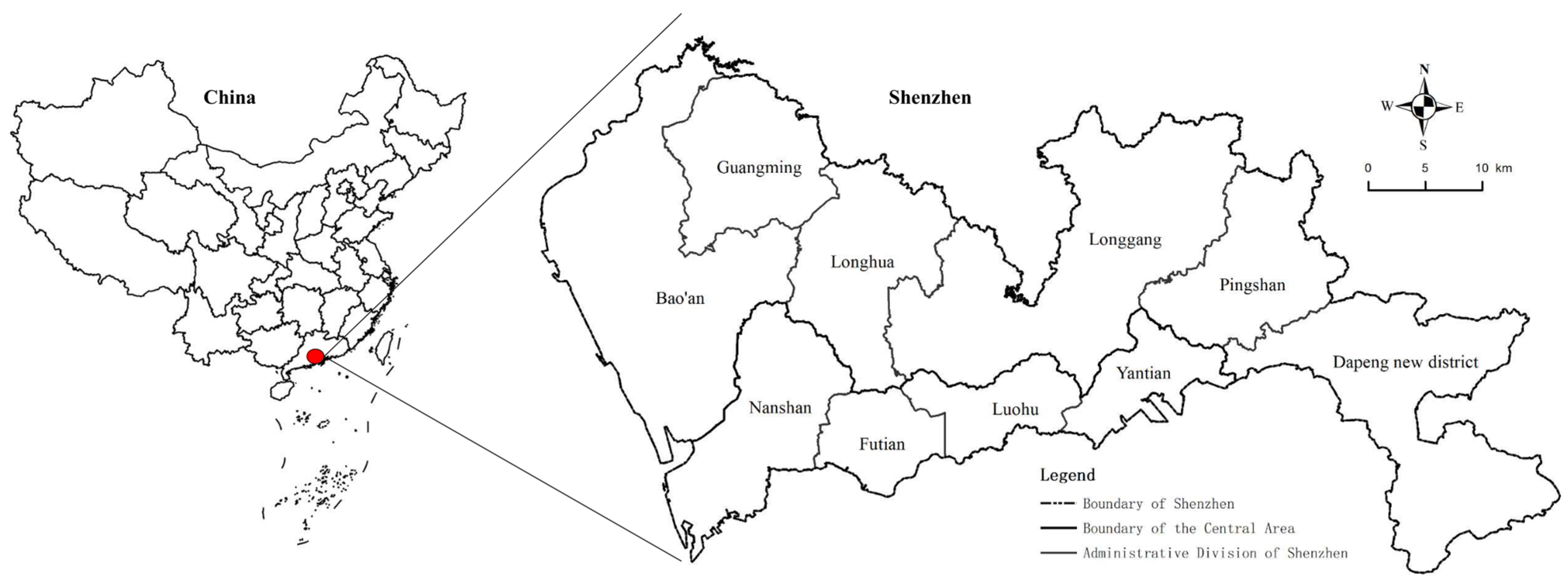
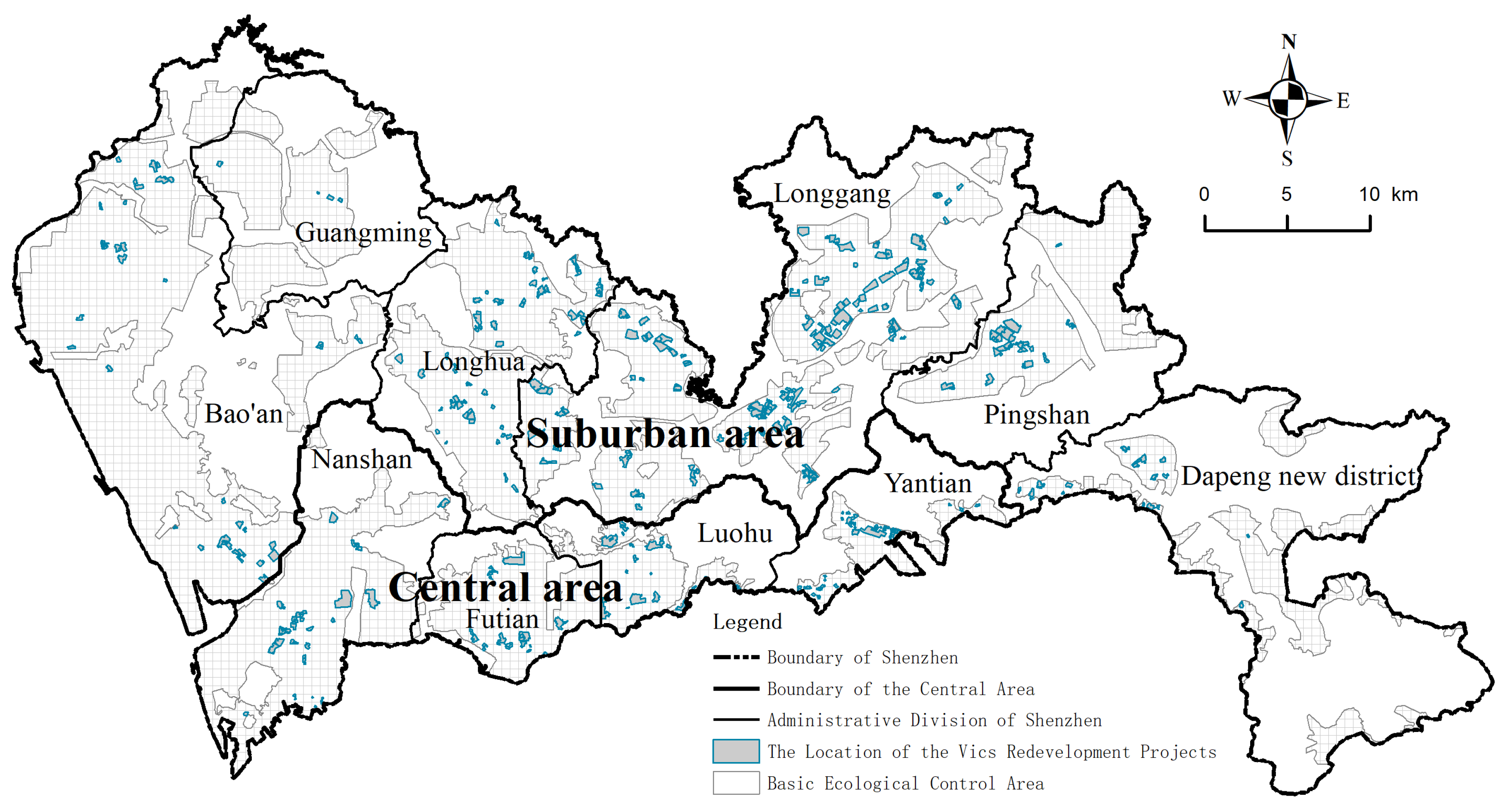
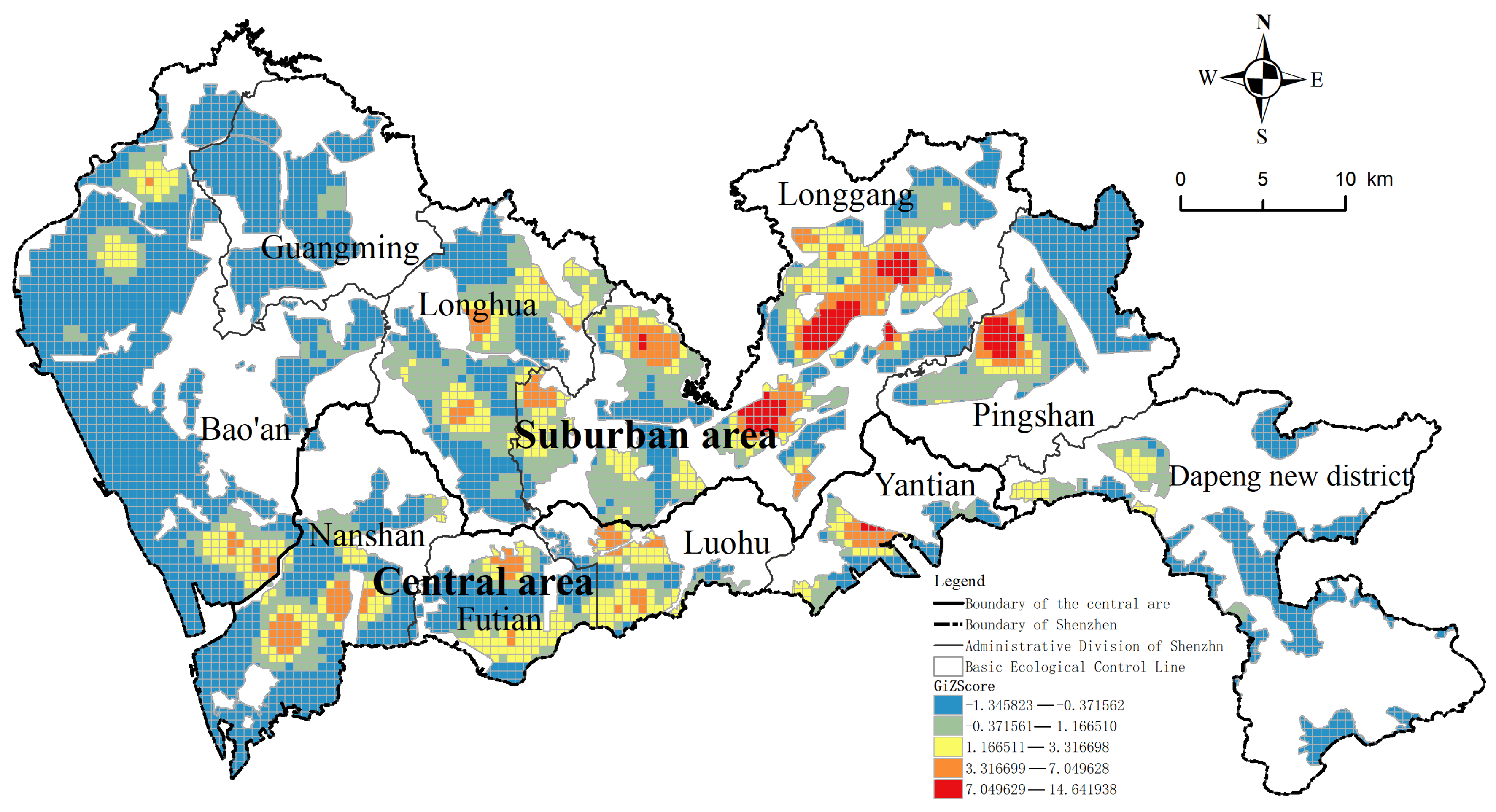
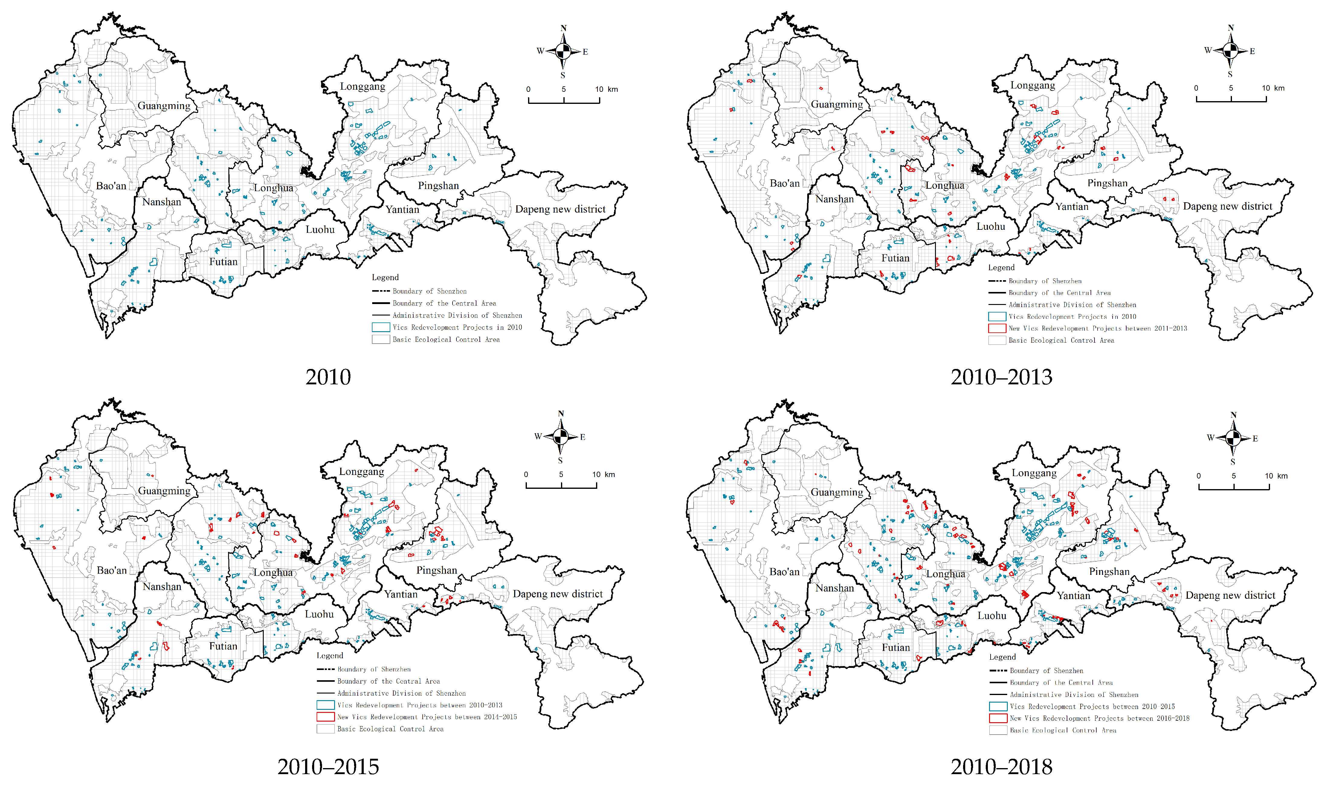
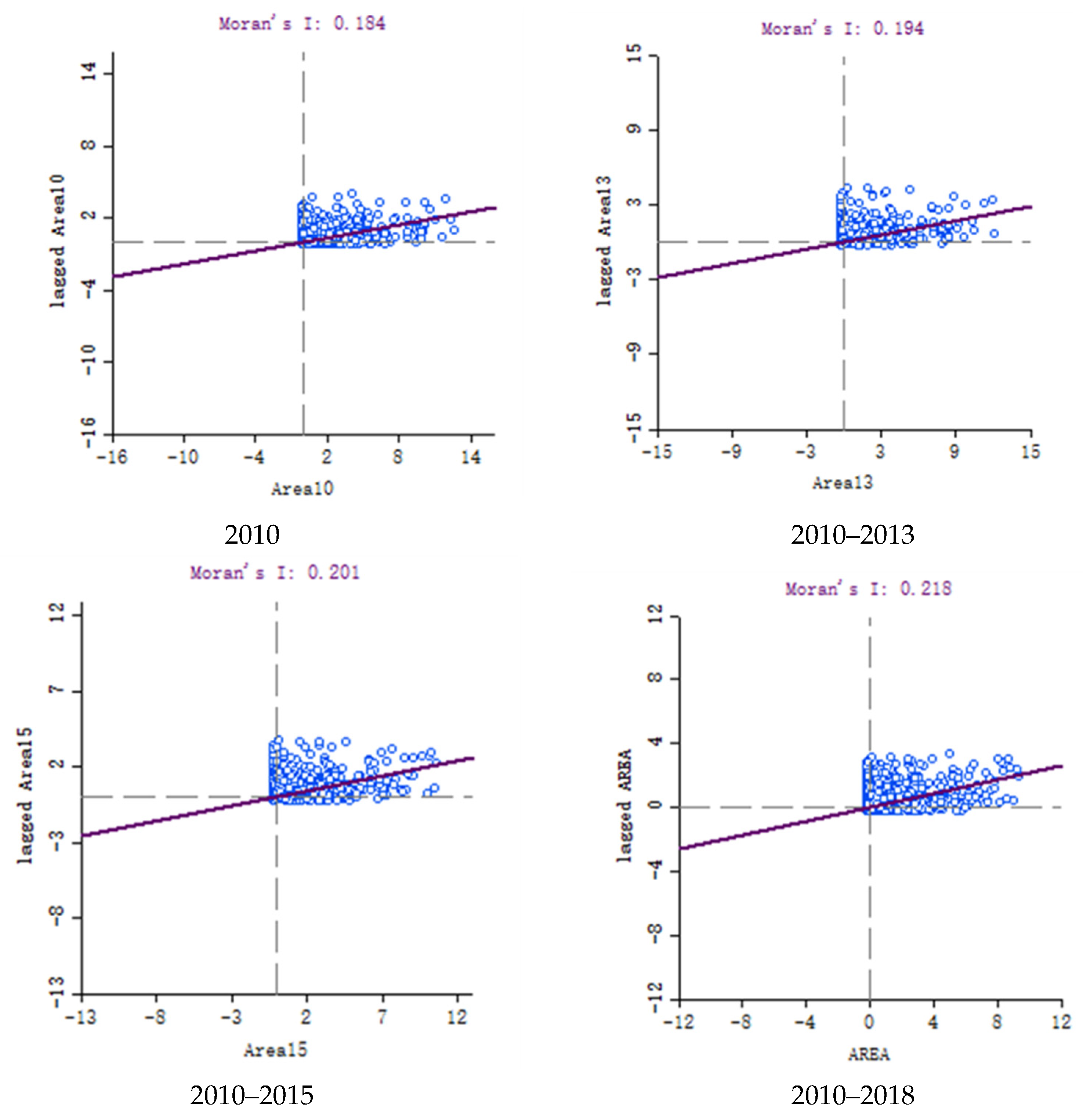
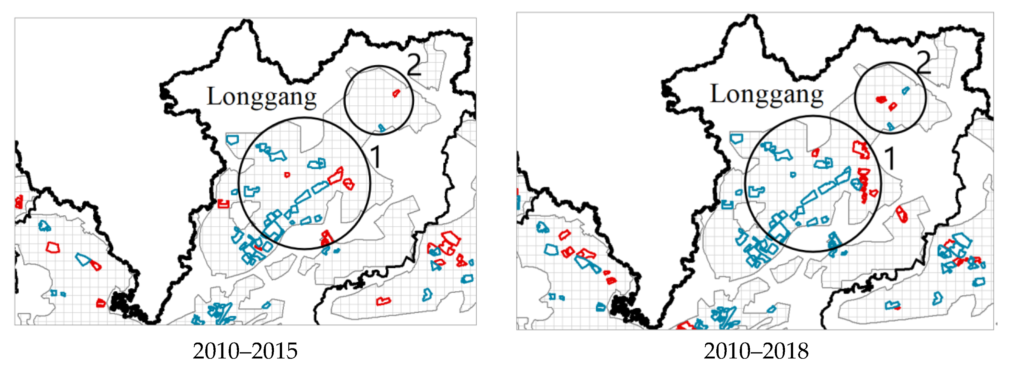
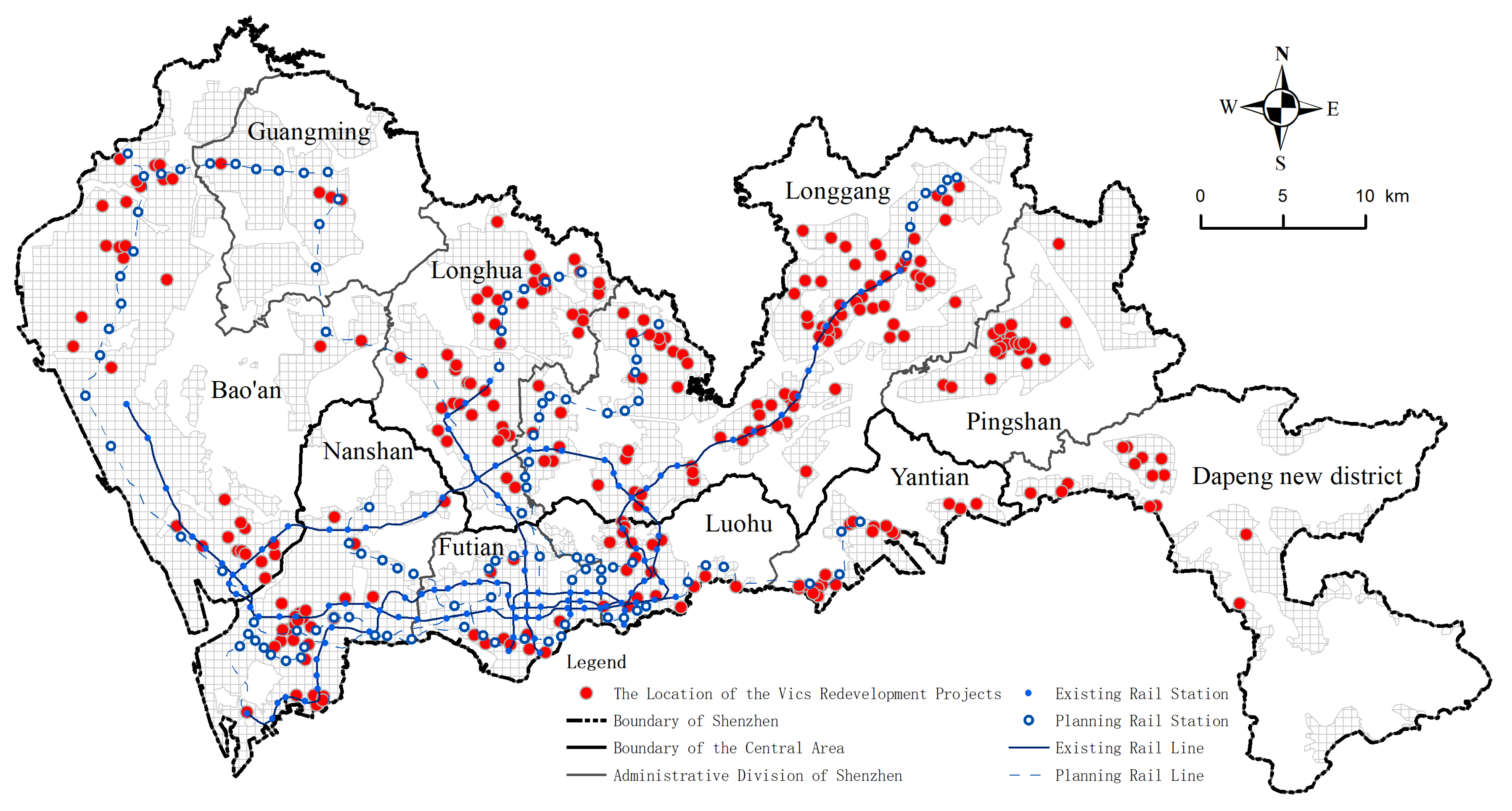
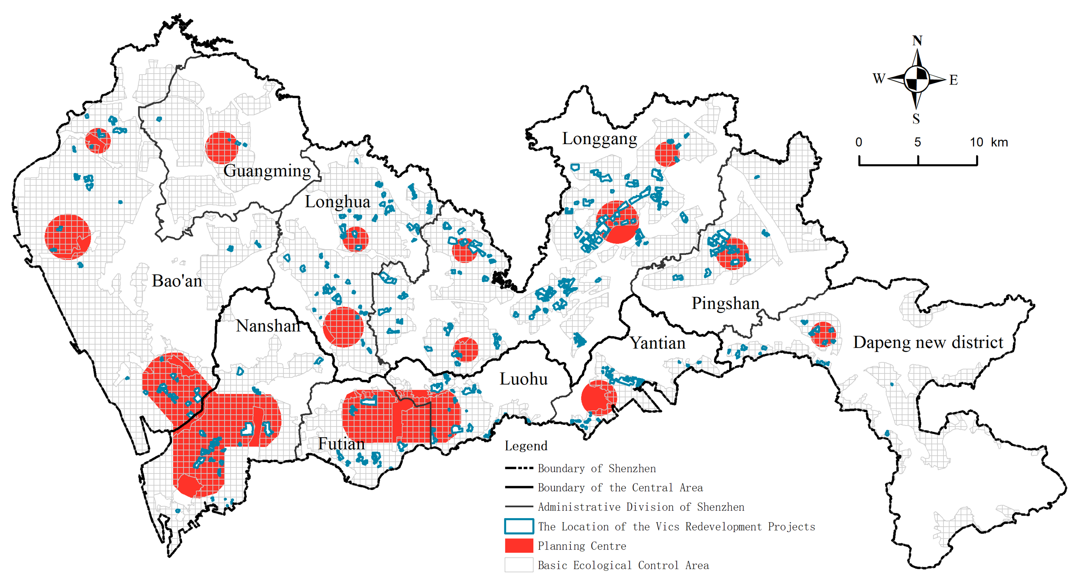
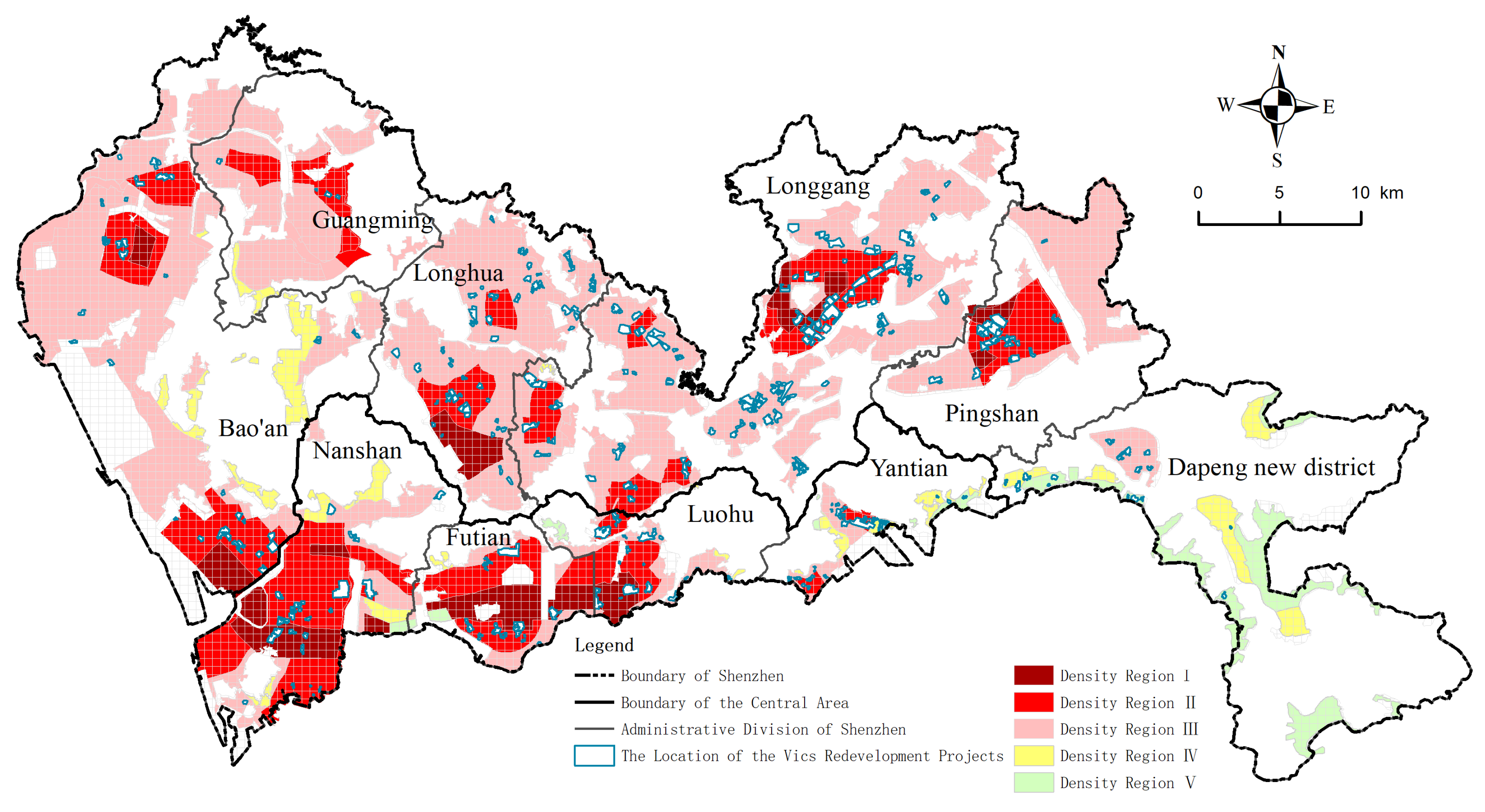
Table 1.
Quantity and area distribution of urban village redevelopment.
| Morphogenetic Zone | Administrative District | Number of Urban Village Plots (n) | % of Total Number | Land Area of Urban Village Plots (ha) | % of Total Area |
|---|---|---|---|---|---|
| Central area | Nanshan | 27 | 9.75 | 302.55 | 8.89 |
| Futian | 10 | 3.61 | 174.37 | 5.12 | |
| Luohu | 18 | 6.50 | 217.58 | 6.39 | |
| Yantian | 19 | 6.86 | 140.44 | 4.13 | |
| Sub-total | 74 | 26.71 | 834.94 | 24.54 | |
| Suburban area | Guangming | 4 | 1.44 | 18.48 | 0.54 |
| Pingshan | 22 | 7.94 | 278.11 | 8.17 | |
| Longgang | 87 | 31.41 | 1489.77 | 43.79 | |
| Longhua | 44 | 15.88 | 376.68 | 11.07 | |
| Bao’an | 32 | 11.55 | 302.79 | 8.90 | |
| Dapeng new district | 14 | 5.05 | 101.63 | 2.99 | |
| Sub-total | 203 | 73.29 | 2567.46 | 75.46 | |
| Total | 277 | 100 | 3402.40 | 100 | |
Table 2.
Proportion of urban village redevelopment in each administrative district.
| Morphogenetic Zone | Administrative District | Total Land Area of Administrative District S1 (ha) | Land Area of Buildable Plots S2 (ha) | Land Area of Urban Village Plots S3 (ha) | S3/S2 (%) |
|---|---|---|---|---|---|
| Central area | Nanshan | 18,753 | 10,415.48 | 302.55 | 2.90 |
| Futian | 7866 | 5241.24 | 174.37 | 3.33 | |
| Luohu | 7875 | 3201.21 | 217.58 | 6.80 | |
| Yantian | 7499 | 2389.00 | 140.44 | 5.88 | |
| Sub-total | 41,993 | 21,246.92 | 834.94 | 18.91 | |
| Suburban area | Guangming | 15,544 | 6673.26 | 18.48 | 0.28 |
| Pingshan | 16,631 | 7554.75 | 278.11 | 3.68 | |
| Longgang | 38,822 | 19,705.24 | 1489.77 | 7.56 | |
| Longhua | 17,558 | 10,853.01 | 376.68 | 3.47 | |
| Bao’an | 39,661 | 23,635.04 | 302.79 | 1.28 | |
| Dapeng new district | 29,538 | 6558.30 | 101.63 | 1.55 | |
| Sub-total | 157,754 | 74,979.61 | 2567.46 | 17.82 | |
| Total | 199,747 | 96,226.53 | 3402.40 | 36.73 | |
Table 3.
Results of Local Moran’s I.
| Name | Clustering Type | ||||
|---|---|---|---|---|---|
| H-H | L-H | H-L | L-L | Not Significant | |
| Urban village redevelopment projects | 347 | 284 | 4 | 544 | 4035 |
Publisher’s Note: MDPI stays neutral with regard to jurisdictional claims in published maps and institutional affiliations. |
© 2021 by the authors. Licensee MDPI, Basel, Switzerland. This article is an open access article distributed under the terms and conditions of the Creative Commons Attribution (CC BY) license (https://creativecommons.org/licenses/by/4.0/).
Share and Cite
MDPI and ACS Style
Lai, Y.; Jiang, L.; Xu, X. Exploring Spatio-Temporal Patterns of Urban Village Redevelopment: The Case of Shenzhen, China. Land 2021, 10, 976. https://0-doi-org.brum.beds.ac.uk/10.3390/land10090976
AMA Style
Lai Y, Jiang L, Xu X. Exploring Spatio-Temporal Patterns of Urban Village Redevelopment: The Case of Shenzhen, China. Land. 2021; 10(9):976. https://0-doi-org.brum.beds.ac.uk/10.3390/land10090976
Chicago/Turabian StyleLai, Yani, Lin Jiang, and Xiaoxiao Xu. 2021. "Exploring Spatio-Temporal Patterns of Urban Village Redevelopment: The Case of Shenzhen, China" Land 10, no. 9: 976. https://0-doi-org.brum.beds.ac.uk/10.3390/land10090976
Note that from the first issue of 2016, this journal uses article numbers instead of page numbers. See further details here.