Article

Historical Agricultural Landforms—Central European Bio-Cultural Heritage Worthy of Attention

1
Faculty of Environment, Jan Evangelista Purkyně University in Ústí nad Labem, Pasteurova 3632/15, 400 96 Ústí nad Labem, Czech Republic
2
Faculty of Science, Jan Evangelista Purkyně University in Ústí nad Labem, Pasteurova 3632/15, 400 96 Ústí nad Labem, Czech Republic
*
Author to whom correspondence should be addressed.
Submission received: 25 April 2022 / Revised: 10 June 2022 / Accepted: 18 June 2022 / Published: 23 June 2022

Abstract

:
Knowledge about past agricultural land management can bring solutions for future needs. One undervalued historical type of historical rural landscape in temperate Europe is termed plužiny. It consists of individual historical agricultural landforms framed by linear woody vegetation. Our multidisciplinary research quantified the distribution of plužiny in Czechia, utilizing archive materials, geographic information systems, and field surveys for verification. Several case studies give merit to the societal relevance of plužiny and justification for their protection and inclusion in landscape planning. We have assessed the contribution of plužiny to secondary geodiversity by describing the landforms morphometrically, using geophysical imaging of their inner structure, and assessing the possible downslope erosive segregation of soil particles. The results of these analyses prove the positive effect of these landscape features on secondary geodiversity and biodiversity at the species level through the process of induced landscape diversification. The results also document management changes during the last 170 years and provide a basis for assessing their present-day endangerment. Although plužiny are less known compared to bocage landscapes of Western Europe, they are similarly valuable. Landscape managers should better recognize the ecological, cultural, and aesthetic values of plužiny as historical agricultural landforms and protect them as a bio-cultural heritage.

1. Introduction

Depending on geographic and geomorphic suitability, humans began to interact with landscapes already in prehistory by selecting sites for settlements and later also for farming. Gradually, these early interactions developed into the deliberate anthropogenic alterations of landscapes to improve their suitability for human needs. The active role of man in these interactions is most obvious in riverine and wetland landscapes, where feedback of the fluvial system is induced by some obstacle to water flow. Sediment transfer is a particularly strong and straightforward manifestation of such feedback on anthropogenic activities and results in some of the most rapidly created anthropogenic imprints in landscapes [1,2]. In non-fluvial landscapes, anthropogenically altered topography is most obvious on steep terrain subjected to terracing as a measure for sustainable farming [2,3]. Since the middle of the 20th century, the development of European farming has growingly been dictated by advanced post-war technological possibilities and unprecedentedly high expectations of persistently growing quality of life; however, that has in recent decades been modified by a return of emphasis on agricultural sustainability and food production safety [3,4]. This paradigm change has brought recognition of more varied functions of land as essential for our future, and this, in turn, prompts for a better understanding of past agricultural solutions studied by archaeomorphology or landscape archaeology [2,3]. Their research can reveal both intended and unintended consequences of past farming and settlement activities for the actual future needs of man, which also include other than purely technological and commercial goals in landscape management, such as prevention of soil degradation and biodiversity decline [2,3,5]. A relevance of historical anthropogenic shape of landscapes for future needs can be demonstrated by historical agricultural landforms (HALs), which are inseparable parts of the plužiny phenomenon.
In Central Europe, there are regions with specific spatial arrangements of parcels that are considered historically and culturally valuable [6,7]. Most landscapes carry imprints of human activities that lasted for several centuries; these imprints are called landscape memory elements [8]. The spatial configuration of these landscapes is linked with the historical term plužina (singular) or plužiny (plural) in the Czech language, loosely translatable as “field system”; its German equivalent is die Flur. It is defined as a mosaic of agricultural parcels belonging to one community [9]. In Czech, the term is etymologically connected with the Czech word for “plough” and has been used in historical–geographic literature [10,11] as well as in recent scientific papers [12,13,14]. Plužiny, a distinct element of historical rural landscapes in Czechia and other regions of Central Europe [15], were established over several centuries. Therefore, Kuna et al. [16] described plužiny as the part of the chronological layer of the cultural landscape of the Middle Ages and the Early Modern Age. The colonization of Central Europe was a culturally, spatially, and temporally specific process. Plužiny, created mostly in a planned manner, reflect the terrain, soil conditions, and farming technologies of the time. The spatial pattern of rural landscapes in Czechia has been established at gradually higher elevations after the 13th century [17]. The strip-field pattern of plužiny is the best-preserved type of field system within rural landscapes in Czechia [18].
Changes in agriculture and society after World War II (WWII) noticeably influenced the Czech landscape pattern. Soon after WWII, the expulsion and transfer of the German-speaking population of former Czechoslovakia abruptly terminated traditional land management in border regions. In 1948, a communist regime took power in Czechoslovakia and enforced a switch to strictly planned agricultural production. The subsequent forceful change of land ownership (referred to as collectivization) aimed to increase crop production. The intensification of agricultural production in Czechoslovakia proceeded faster than in non-communist Central European countries. The intensity of collectivized farming varied across the country. Nevertheless, the traditional mosaic of small fields, meadows, pastures, and orchards was generally obliterated. Wherever feasible, fields were merged and drained on a large scale. Imprints of private ownership in the landscape, represented by parcel borders spatially marked by linear vegetation, stone walls, and baulks, as well as field margins, were purposefully but not fully effaced. The processes of collectivization and agrotechnological land adjustments completely changed the spatial arrangement of parcels, especially in agriculturally favourable fertile lowlands [19,20]. Traces of plužiny have been preserved as mementos of traditional agriculture, mostly in remote regions and highlands with conditions unfavourable for modern farming technologies [21].
Long-term land cultivation in rural landscapes has produced several types of anthropogenic landforms, including historical anthropogenic landforms (HALs) on which we focus in this study because they are substantial elements of plužiny. The two landforms of particular interest are agricultural stone walls and lynchets. They were built soon after the establishment of settlements as settlers removed stones from fields to farm the land. The stones were placed mostly along field margins [11], forming linear landscape elements of agricultural stone walls. Such stone accumulation extends in the downslope or horizontal direction, being almost symmetrical in the horizontal cross-section. Lynchets, also referred to as ploughed–on terraces, originate from the process of soil accumulation on parcel boundaries, accelerated by long-term farming activities on steep slopes, including tillage and stone removal from fields to their margins, oriented along terrain contours.
Various aspects of plužiny and HALs, their inseparable parts, have been studied by several authors [8,12,13,14,15,22,23,24,25,26,27,28]. Based on a literature survey, we can say that HALs and plužiny on a broader scale provide numerous benefits. Terraces reduce soil erosion and downslope sediment transport, causing persistent changes in morphology at a local scale [29]. These landforms thus support long-term soil conservation [30], reduce runoff by water retention [31,32,33], and improve topsoil retention [34]. However, the bedrock is a crucial factor in sustainable farming. A poorly cohesive bedrock can result in severe soil erosion, such as in the Stołowe Góry Mts in Poland, as documented by Latocha [35,36]. These aspects of HALs have been documented and studied in neighbouring Poland [8,37,38], Germany [29], and France [39,40].
HALs covered by vegetation act in the landscape similarly as hedgerows, but their origin and character are different. The importance of hedgerows in rural landscapes has already been well documented [41], especially their effect on biodiversity [42,43,44,45,46], microclimate [47], erosion rates and pesticide flow in the landscape [48,49]. By contrast, plužiny still await their recognition.
Plužiny represent parcel divisions with a specific spatial configuration, which has remained almost untouched during the last dynamic century. In some areas, this integral layer of Central European historical landscapes has been preserved in fragments. Elsewhere, it has been preserved, plentifully, depending on local landscape dynamics and heterogeneity. Historical cultural landscapes are considered worthy of protection by the European Landscape Convention [50], as they are usually ecologically more stable than modern anthropogenic landscapes [51]. They also provide information about the culture and history of our ancestors [52] and contribute to the creation of local cultures and identities [50,53]. There is a long tradition of research on traditional agricultural landscapes containing historical agricultural structures in Slovakia, which also applies to HALs in a broad sense of the term [25,54,55]. HALs are usually visually highlighted in the landscape by the presence of accompanying linear woody vegetation. Because of this, regions with high concentrations of HALs have been referred to by Sklenička et al. [14] as medieval hedgerow-defined field patterns. Regular arrays of lynchets or stone walls with their woody vegetation cover as linear landscape elements provide aesthetic, recreational, and heritage values [56]. HALs provide undisputable values with respect to landscape character [57]. This fact is reflected by the delimitation of semi-bocage and bocage landscape-type regions within Europe [58]. Probably due to the increasing number of studies on strip-field patterns in Czech landscapes, Montgomery et al. [36] mentioned Czechia as a country of bocage landscapes. The newer European agricultural landscape typology of van der Zanden et al. [59] distinguished these regions as enclosed landscapes of various land-use intensities typically found with high occurrence of linear elements (based on [60]), locally abundant in Great Britain, Ireland, Germany, and France [59]. Bocage landscape patterns were created for country-specific purposes, particularly to provide fences between parcels, so their history, structure, topography, and landscape functionality differ from those of Central European plužiny.
The plužiny as a system of HALs can be considered a bio-cultural heritage within the new paradigm of landscape conservation and planning [61], with more stress put on sustainability of land use and food production. HALs and the overall patterns of plužiny in hilly regions are currently threatened by land abandonment, which may lead to the overgrowth of crop land by woody vegetation from parcel boundaries [62,63]. Many sites with abandoned HALs are undergoing a spatially diverse process of succession under the influence of factors, some of them described by Latocha et al. [8] for Polish HALs, who documented their deterioration caused by the spread of woody vegetation.
Aspects of the problematic conservation of these landscape elements can be illustrated on the example of the Krušné Hory Mts, a mountain range running along the borders of Czechia and Germany (Saxony). Here HALs are still abundant, as has been recently documented by Walczak et al. [64]. In Saxony, such HALs are protected as a specific habitat (in German der Steinrücken) by the Saxon Nature Protection Act (No. 653-2/2, § 21 within the meaning of § 30), being on the Red List of German Habitats categorized as critically endangered and those endangered by collapsing [65]. Grunewald and Syrbe [66] reported 348 ha of such habitats in Saxony. By contrast, Czech nature protection law has no special category assigned to these landscape elements. An inconsistent approach to the delimitation of these habitats is evident from the results of the national habitat mapping [67]. That is probably caused by their anthropogenic origin reflected in the vegetation cover and high habitat diversity. Comparable HALs are not mapped or mapped mostly as a mosaic of mountain hay meadows and Nardus stricta swards, or even as just Nardus stricta swards. Habitat protection can be substituted by protection at the landscape level. For example, in the eastern part of the Krušné Hory Mts on the Czech side, a natural park, called Východní Krušné Hory, was established to preserve the local character of the landscape—HALs being one of the landscape elements which are explicitly protected.
Our work aims to bring a multidisciplinary view of the HALs, associated with plužiny phenomenon on the examples of Czech cultural landscapes to justify their relevance for 21st century society, and to evaluate the need for their protection and inclusion in landscape planning. We aim to specify the extent of plužiny presence at a national level of Czechia by use of geographic information systems (GIS), to verify these findings in field surveys, and to document changes in their management up to the present, utilizing archive cartographic materials. We assessed secondary geodiversity associated with the landforms, focusing on the morphometric surface of HALS, their inner diversity, and their influence on soil translocation along the slope gradient. Our other aim is to evaluate the effects of the existence of HALs on biodiversity indicated by plant diversity and woody vegetation persistence in the landscape. Data on the biodiversity of selected invertebrate groups in neighbouring habitats also provided information about the effect of HALs on biodiversity. Our transdisciplinary approach draws a complex image of the values inherent in plužiny in the landscape and documents them. We finally evaluate whether the landscape features are worthy of protection in light of the needs of the 21st century as a part of a bio-cultural heritage in rural landscapes.

2. Materials and Methods

This multidisciplinary study quantifies the spatial extent of HALs at a national level. Individual case studies summarize (unintended) benefits of the plužiny phenomenon, associated HALs, and accompanying vegetation for the 21st century.
We selected our study based on preliminary knowledge of their existence, utilizing geographic information system tools and the previous long-term work of the research team members. Their locations are shown in Figure 1 and Supplementary Material SA.

2.1. Terminology

In this study, we focus on two linear types of HALs: agricultural stone walls and lynchets (Figure 2), which are integral parts of the plužiny. We distinguish between two concave subtypes of agricultural stone walls (Figure 2a): those comprising loosely piled stones of various shapes and sizes, and those stacked from mostly flat or rectangular stones. Lynchets (Figure 2b) are described as terrace platforms with a steep slope riser. The upper terrace platform is separated from the riser by an upper edge and the lower terrace platform by a lower edge. Another term applicable to such HALs is “baulk”, which is used mainly for field margins and lynchets without woody vegetation. Based on the structure and the material of the riser, we differentiate three subtypes of lynchets (Figure 2b): (1) soil lynchets without stones on their surface or inside the riser, (2) lynchets with stones on the riser surface but not deep beneath the surface of it, and (3) lynchets with constructed stone walls. The local bedrock affects the shape and amount of stones. It is, therefore, a greatly important factor in determining morphometric characteristics such as the final height and width of the stone wall and riser, which vary considerably.

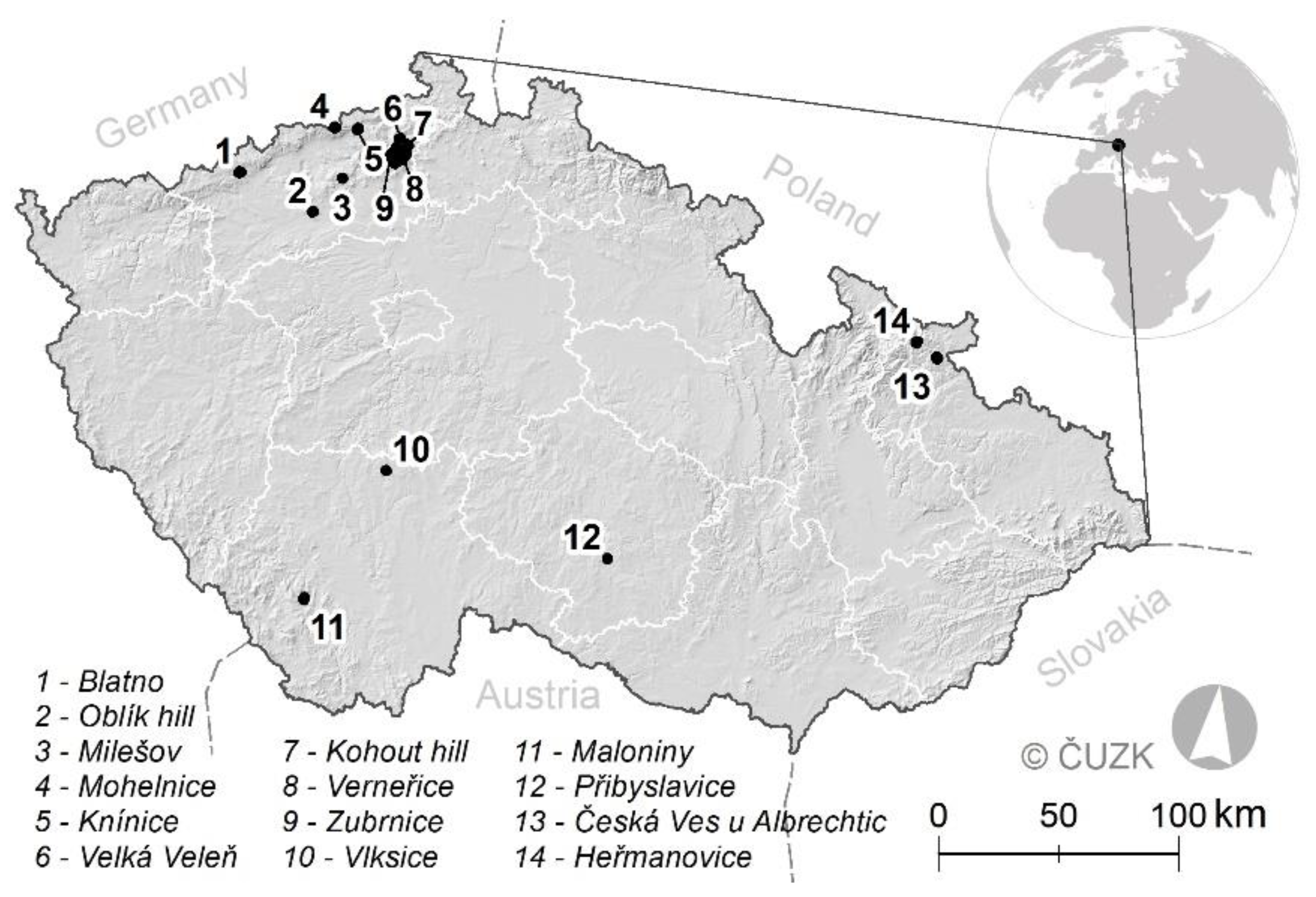
2.2. Spatial Distribution of HALs in Czechia

Mazáková [68] presented the first estimate of the distribution of HALs in open landscapes of Czechia based on the visual inspection of sharp terrain slope changes in a base map of Czechia at a scale of 1:10,000 and the presence of linear woody vegetation in an actual orthophotographic map of Czechia (both WMS layers; Czech State Administration of Land Surveying and Cadastre, hereinafter ČÚZK). Forested areas were not examined because the potential relevance of forested HALs for awarding protection status is low. The results were partially summarized in [68]. Examples of the interpretation of these input materials are provided in Supplementary Material SB. The same methodology was employed to create a national layer of HALs for the entire area of Czechia (78,866 km2). We performed field verification of selected sites, based on each point of HALs presence verification, to separate positively identified, falsely identified, and unrecorded HALs. The point layer was relativized by the features’ density expressed within a hexagonal grid of 5 km2. Data processing and analyses were performed using ArcGIS software (ESRI 2020, Redlands, CA, USA).

2.3. Management of HALs

The farming management of HALs varied over the course of history, which is reflected by archive cartographic and photographic materials. To document this variability, we used maps of the Second Military Survey in a scale of 1:28,800, created in the Austro-Hungarian Empire during the first half of the 19th century. Another source of detailed information (scale 1:2800) on parcel land use was the Franciscan Cadastre, a land registry produced for the Austro-Hungarian Empire in the first half of the 19th century (ČÚZK). The archive cartographic materials were georeferenced and processed on the basis of the methodology by Cajthaml et Pacina [69]. Archive aerial photographs taken in 1938, 1946 (Archive of Aerial Survey Images of the Military Geographical and Hydrometeorological Office—Czech Ministry of Defence, hereinafter CMD), and 1954 (Czech Environmental Information Agency) also served as sources of information for the identification of HALs, and the visualization of the spatial configuration of woody vegetation during periods when HALs were actively used. Several sites in Czechia were selected to illustrate the historical presence of these landforms and the variability of the land use of the parcels in the past.

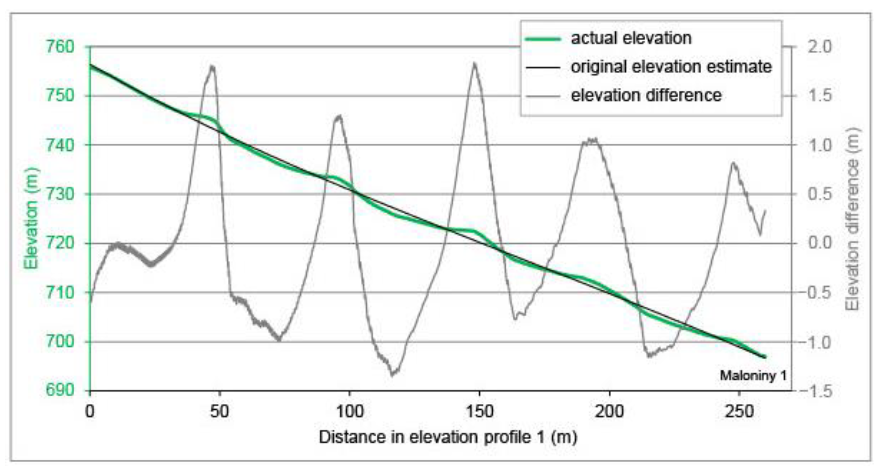
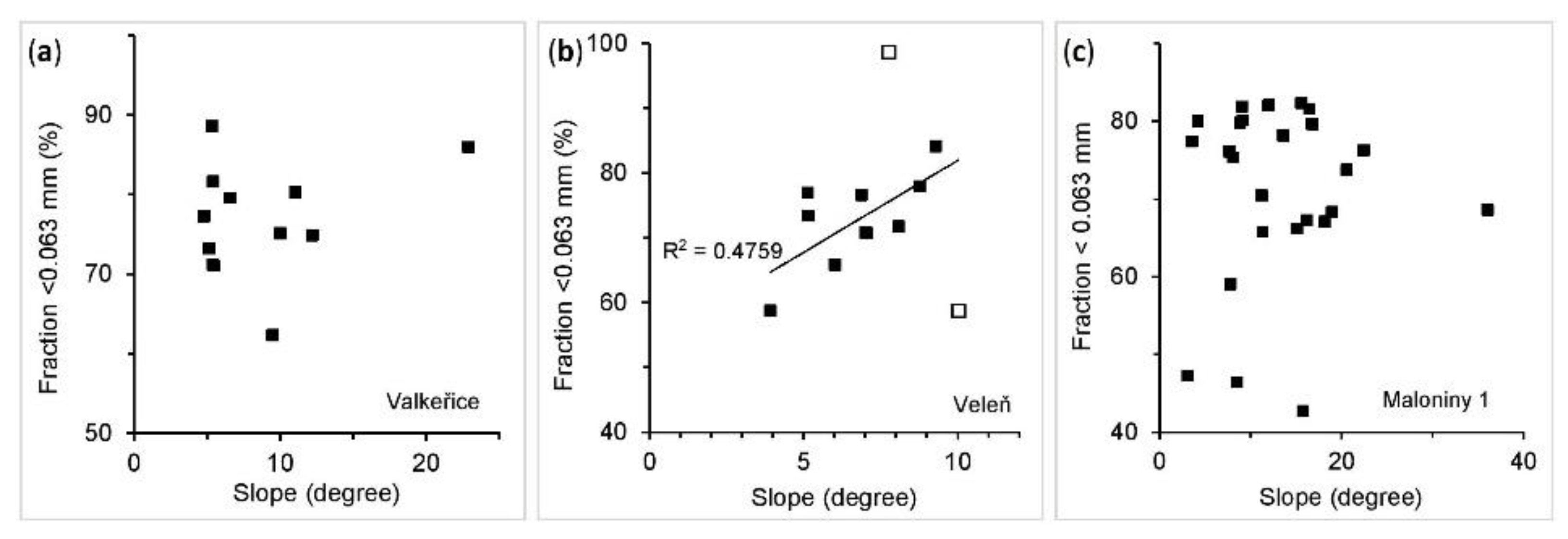
2.4. Geomorphic Diversity of HALs

The selected sites were thoroughly examined to describe the microrelief variability associated with HALs. LiDAR data and fifth-generation digital terrain model (DTM) datasets (DTM 5G, ČÚZK) for Czechia (the most detailed national digital relief model available) were used to identify and delimitate HALs in combination with field survey methods. Our LiDAR datasets for selected sites were acquired with a Riegl VUX1-LR scanner mounted on a small aircraft, with the following parameters: flight height of 300 m, scanning overlap of 50%, and stripe distance of 200 m. The resulting data (point density of approximately 20 per m2) were post-processed using PosPac software (Applanix, Richmond Hill, ON, Canada) and further processed in RiProcess (Riegl, Horn, Austria), resulting in a digital surface model. Vegetation was filtered out, and only “bare ground” was used for the field survey and identification of risers.
Relief transects were created to describe selected HALs with precise morphometric specifications based on geodetic GPS (South S82 GNSS Rover, vertical precision 15 mm, horizontal precision 8 mm) and LiDAR data. Information on the subsurface structure of risers was obtained by dipole electromagnetic profiling (DEMP), also referred to as electromagnetic imaging. DEMP is a contactless method for acquiring apparent (alternating, ionic) electric conductance via the induction of a secondary electromagnetic field in a shallow subsurface. The nominal depth of the equipment used was 2.3 m. Using the instrument CMD Mini Explorer 6 L (GF Instruments, Brno-Medlánky, Czechia), continuous measurements were taken along transects across the landforms of interest at three study sites. Differences in conductivity were assessed visually to distinguish the inner structure of each HAL. The data were processed by EM4Soil software (version 3.05, 2018; EMTOMO) to devise an inversion model of soil conductivity.
The transport of material, resulting from long-term soil cultivation and erosion was expected in the form of possible downslope movement of the finest soil fractions from steeper slopes to gentler or horizontal lower parts of terrace platforms. Grain-size analysis was therefore conducted for particles smaller than 2 mm to assess changes along with the slope profile at three study sites. The granulometric analysis was performed using an Analysette 22 NanoTec device (Fritsch, Idar-Oberstein, Germany) based on laser scattering. The measurement size range was 0.01–2000 mm. We relied on the disintegration of particle aggregates in a 40-kHz ultrasonic dispergator integrated in the granulometer.

2.5. Ecological Functions of HALs

Geodiversity is often related to the diversity of organisms. The spatial dynamics of woody vegetation accompanying HALs were evaluated based on archive aerial imagery (CMD; GEODIS BRNO, spol. s r.o., Brno, Czech Republic) in the context of land-use management, elevation, and slope in the Verneřice region (approximately 28 km2 in area). The bitemporal spatial analysis compared the extent of accompanying woody vegetation between 1938 and 2002.
The variability of habitats brought to the landscapes by HALs is reflected inter alia by the species assemblages of plant and insect communities present. The diversity of communities was assessed by comparing the composition of vascular plant species on the landforms and in surrounding grasslands and/or edge communities. Botanical surveys were conducted between 2017 and 2019, focusing on two study sites: Oblík Hill near Raná village and the base of Kohout Hill near Valkeřice village in the České Středohoří Mts. The compositions of species was summarized for the following local habitats: inner vegetation on the HALs, marginal habitat, and adjacent grassland. For the Kohout site, lists of species were compiled without including the transitional marginal habitat, as the site diversity on this site was generally lower, with prevailing mesophilic plant species. By contrast, the Oblík site is a highly diverse hotspot with specific natural conditions preferred by thermophilic plant species. Based on the lists of all species present, the Jaccard index was calculated to assess the similarity in species diversity between habitats sampled [70]. The characteristics of the sites and locations of the samplings are summarized in Supplementary Material SC.
The diversity if selected groups of invertebrates was studied. At the Milešov site (in the České Středohoří Mts), species of spiders (Araneae) and ground beetles (Coleoptera: Carabidae) were collected and compared among three types of habitat: within corridors of the HALs (linear vegetation on walls/risers), surrounding grassland, and adjacent woodland. In total, 37 conventional pitfall traps were placed and collected during the 2015 vegetation season. The Simpson diversity and Bray–Curtis indices were calculated to compare the diversity and similarity of invertebrate communities among habitats [71]. The characteristics of the sites and locations of the samplings are presented in Supplementary Material SD.

3. Results

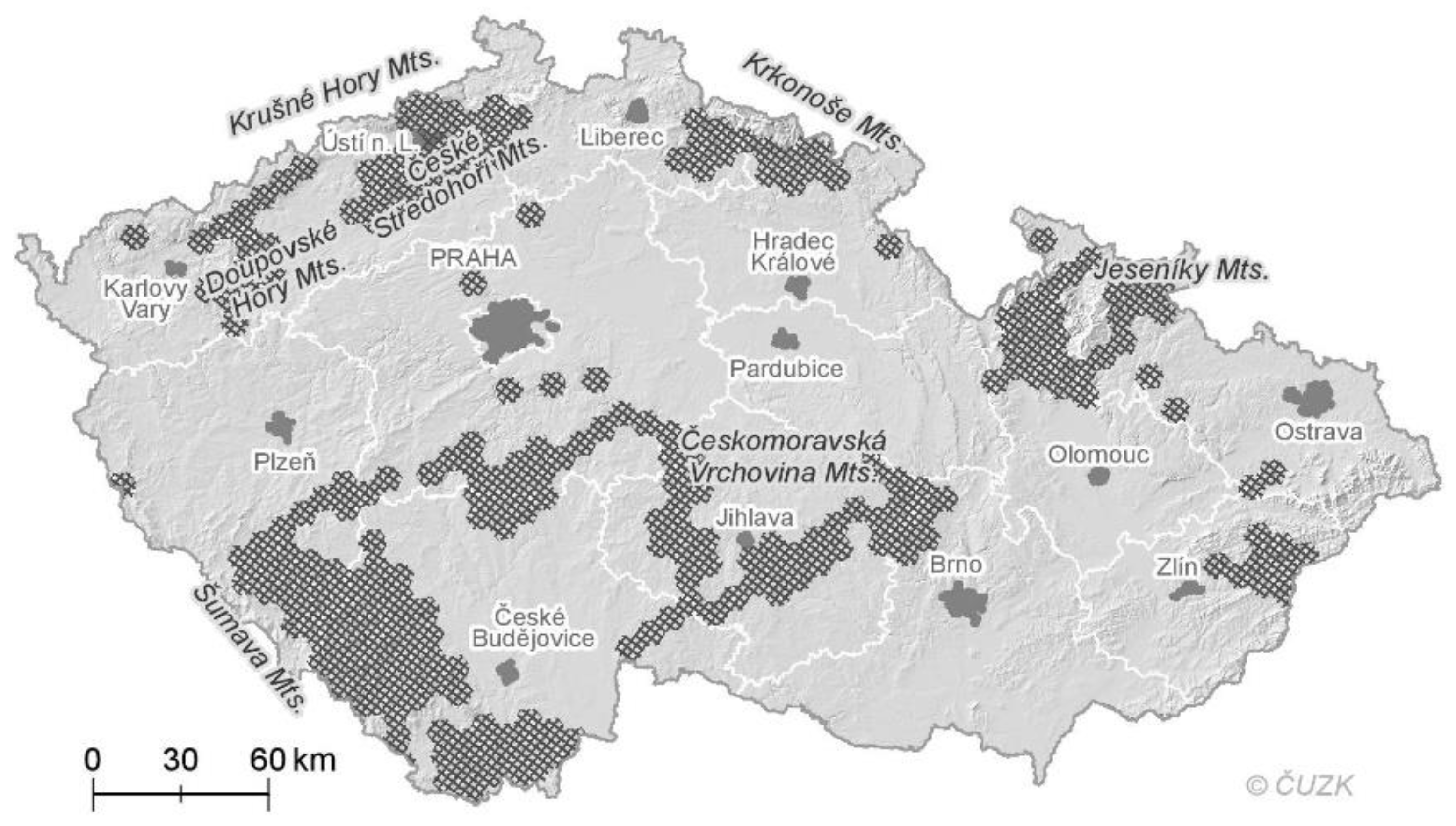
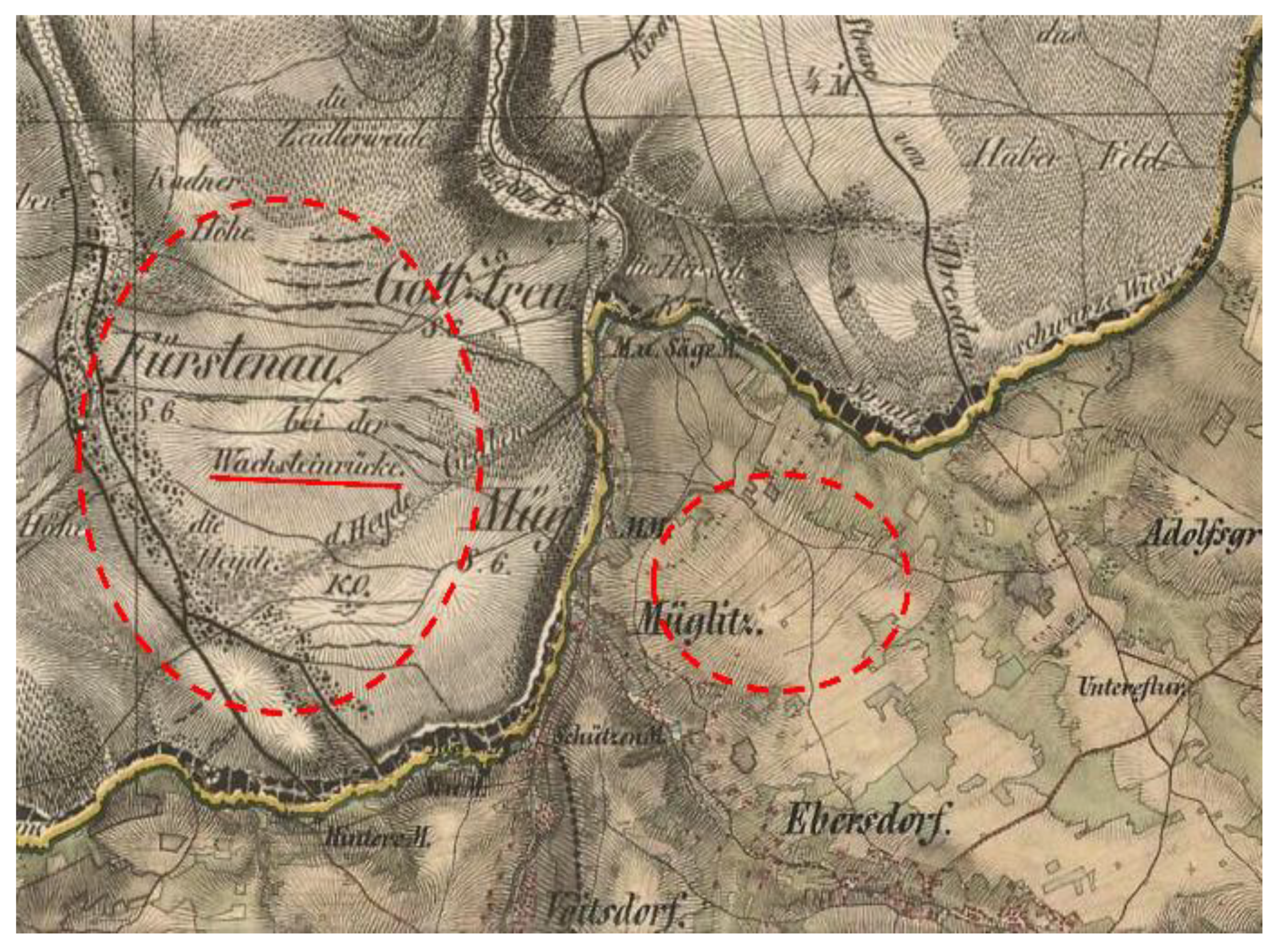
3.1. Distribution of HALs in Czechia

Manual interpretation of cartographic materials allowed to chart the spatial distribution of HALs (in density per km2) in Czechia (Figure 3). High concentrations of HALs are found in the Šumava Mts and in their foothills, in the České Středohoří Mts, Krušné Hory Mts, Doupovské Hory Mts, and parts of the Českomoravská Vrchovina Mts, in the region to the east of the town Zlín, in the Jeseníky Mts, and in the Krkonoše Hory Mts (Figure 3). Because the distribution is estimated rather coarsely, we verified it in the field. The results of our fieldwork show that our map-based evaluation slightly underestimated the extent of actually existing features. Almost three-quarters of the HALs were confirmed, only 4% of supposed HALs were falsely identified, and 25% of actual existing ones were missed. Based on these results, we can state that HALs are not rare elements in Czech rural landscapes. Nevertheless, they are mostly present at higher elevations. The possible role of other factors cannot be tested based on the data we analysed. For this reason, further digitization of HALs is ongoing within our research framework.
There is considerable variability in the spatial configuration of the landforms at the study sites. HALs can be found in parallel sequences of stone walls or lynchets on higher slopes, where the landforms are also present along the hillside. Wall shape varies along HALs, as documented for the Heřmanovice site in Figure 4a, where remnants of stacked stone walls, lynchets, and stone piles can be found locally. Parallel sequences of HALs were noted, especially in the regions of the Jeseníky, České Středohoří, and Krušné Hory Mts. Some HALs exceeded 1 km in length, for example, at Knínice in the Krušné Hory Mts (17 lynchets with lengths of 0.8–1 km; Figure 4b). The small-scale mosaic of parcels is framed by HALs, as shown in Figure 5a. Another aspect relevant to downslope elevation profiles is the presence of farm roads along parcel boundaries. These historical roads, some of them still noticeable in the field, are being used to access the cultivated land, mostly near and along stone walls or just along the lower edge of lynchets (Figure 4b and Figure 5b).

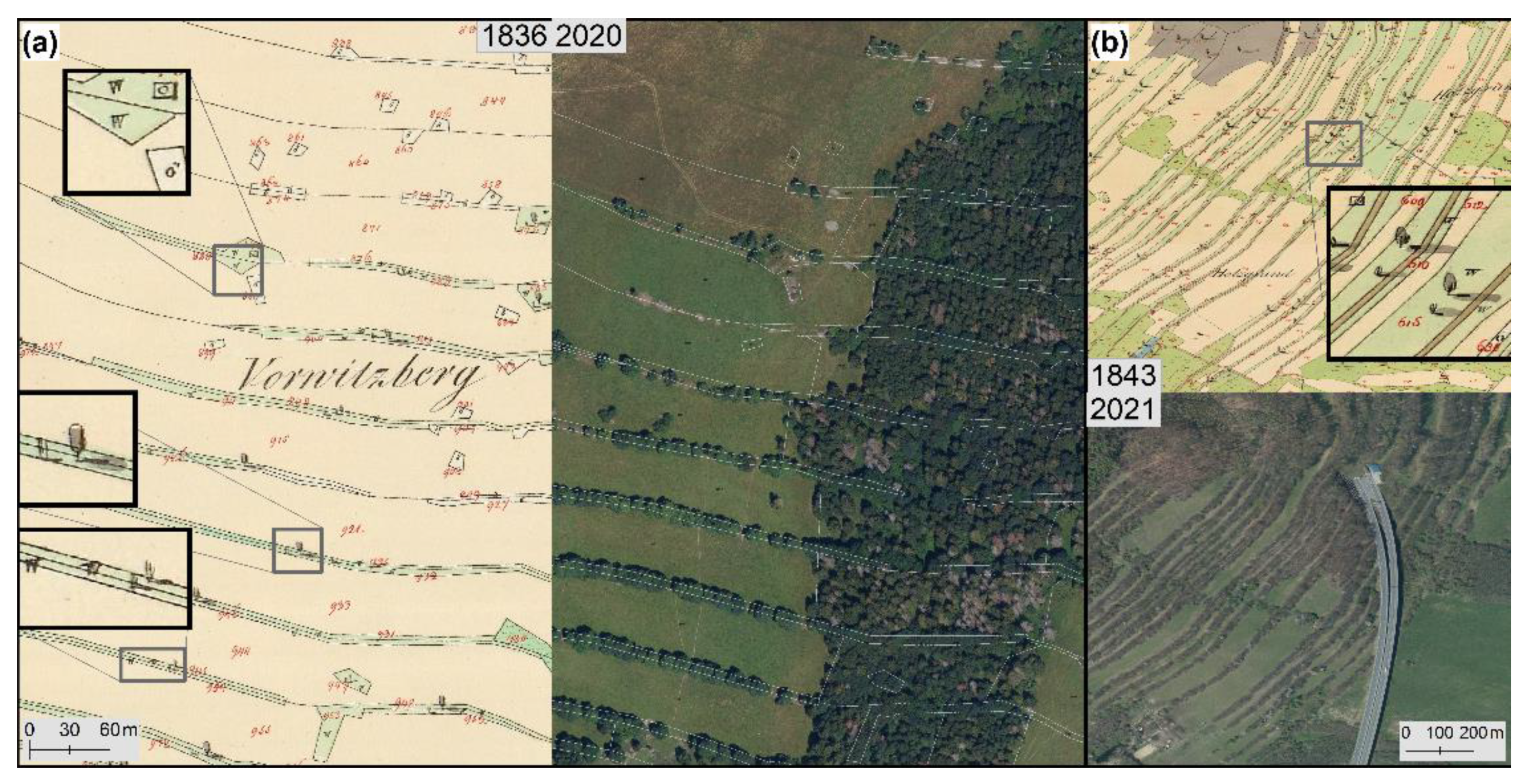
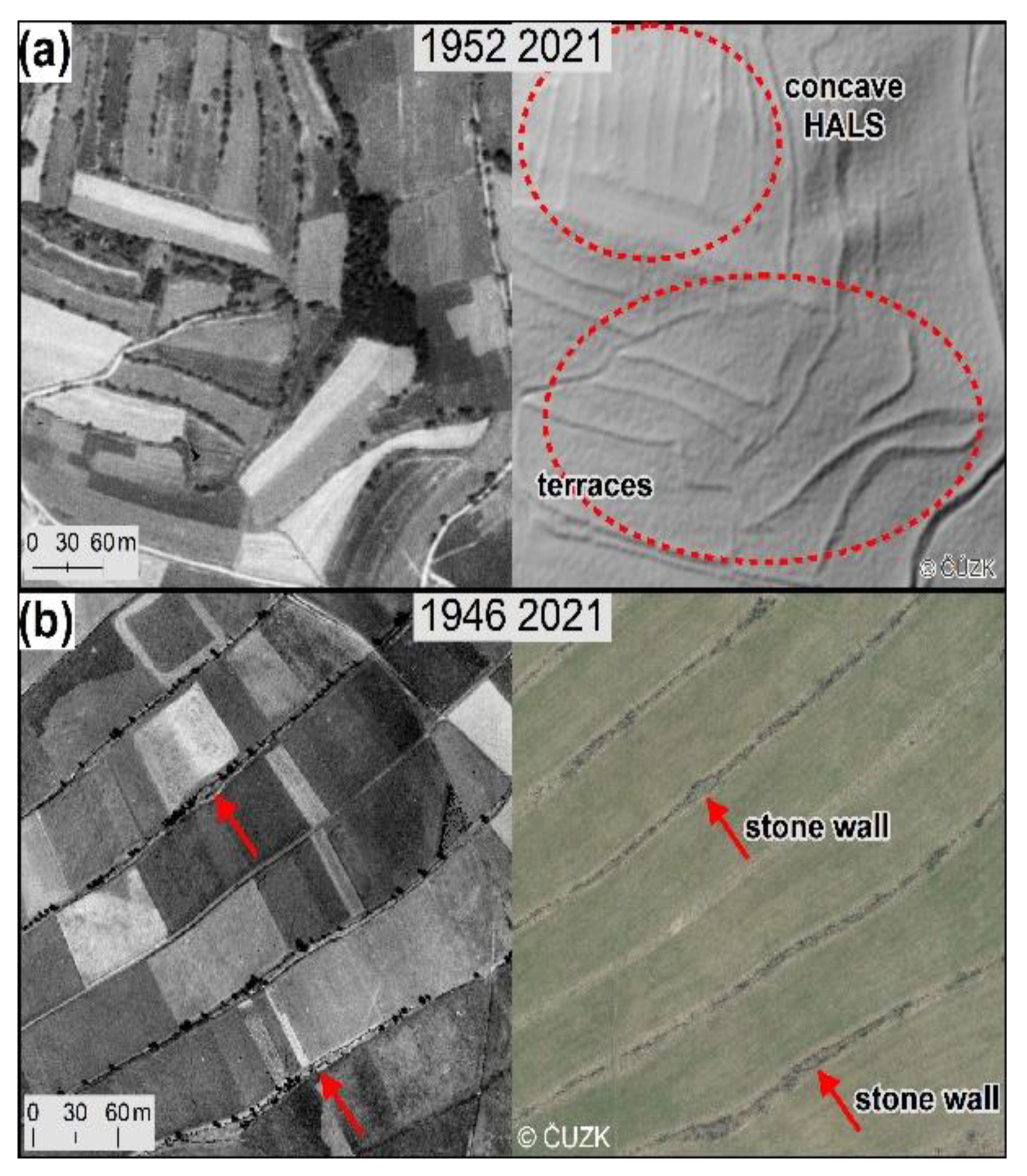
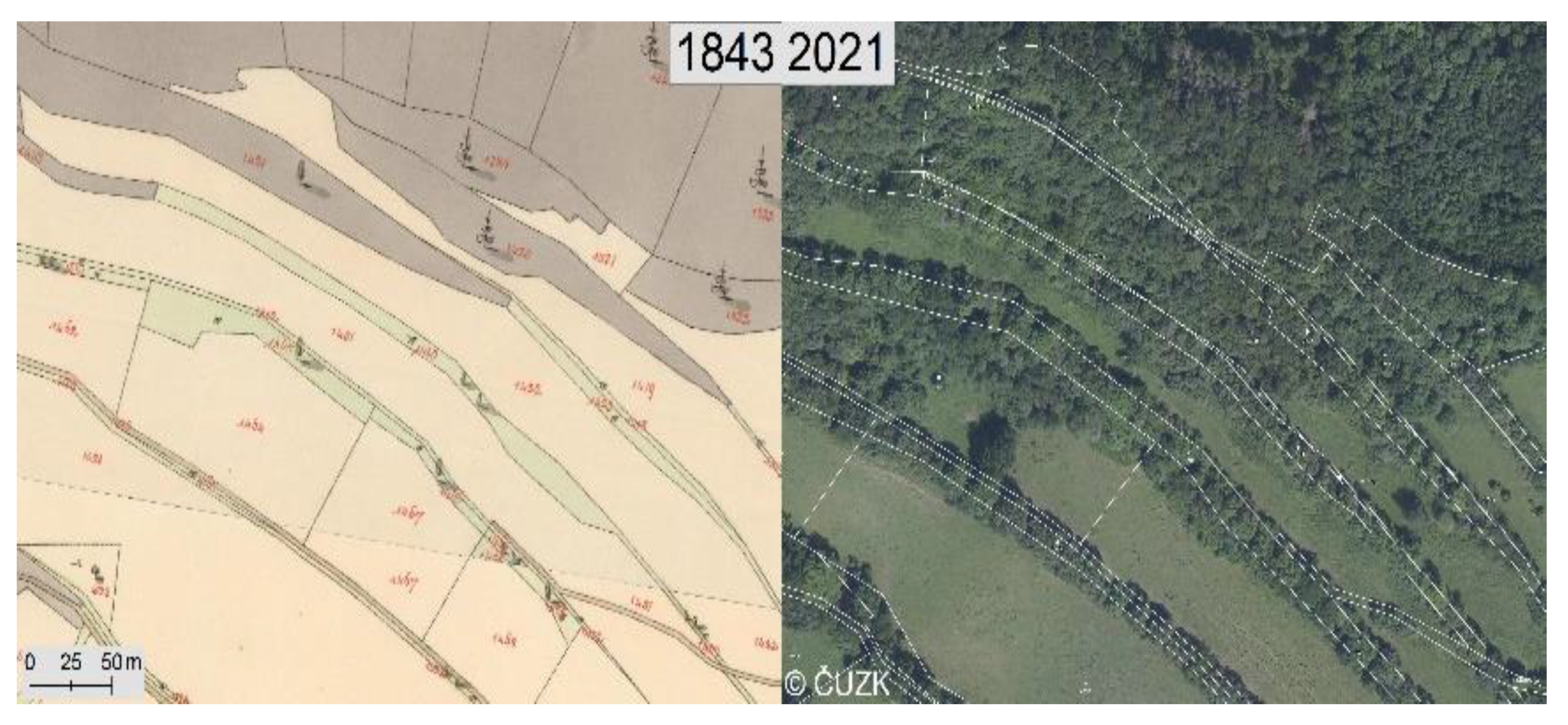
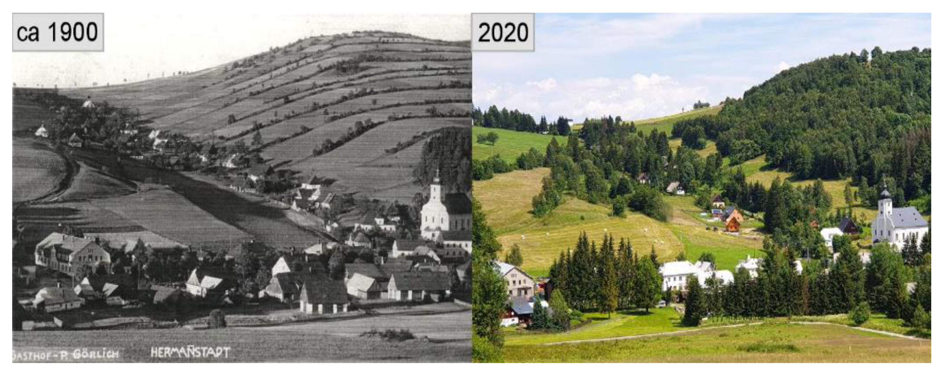
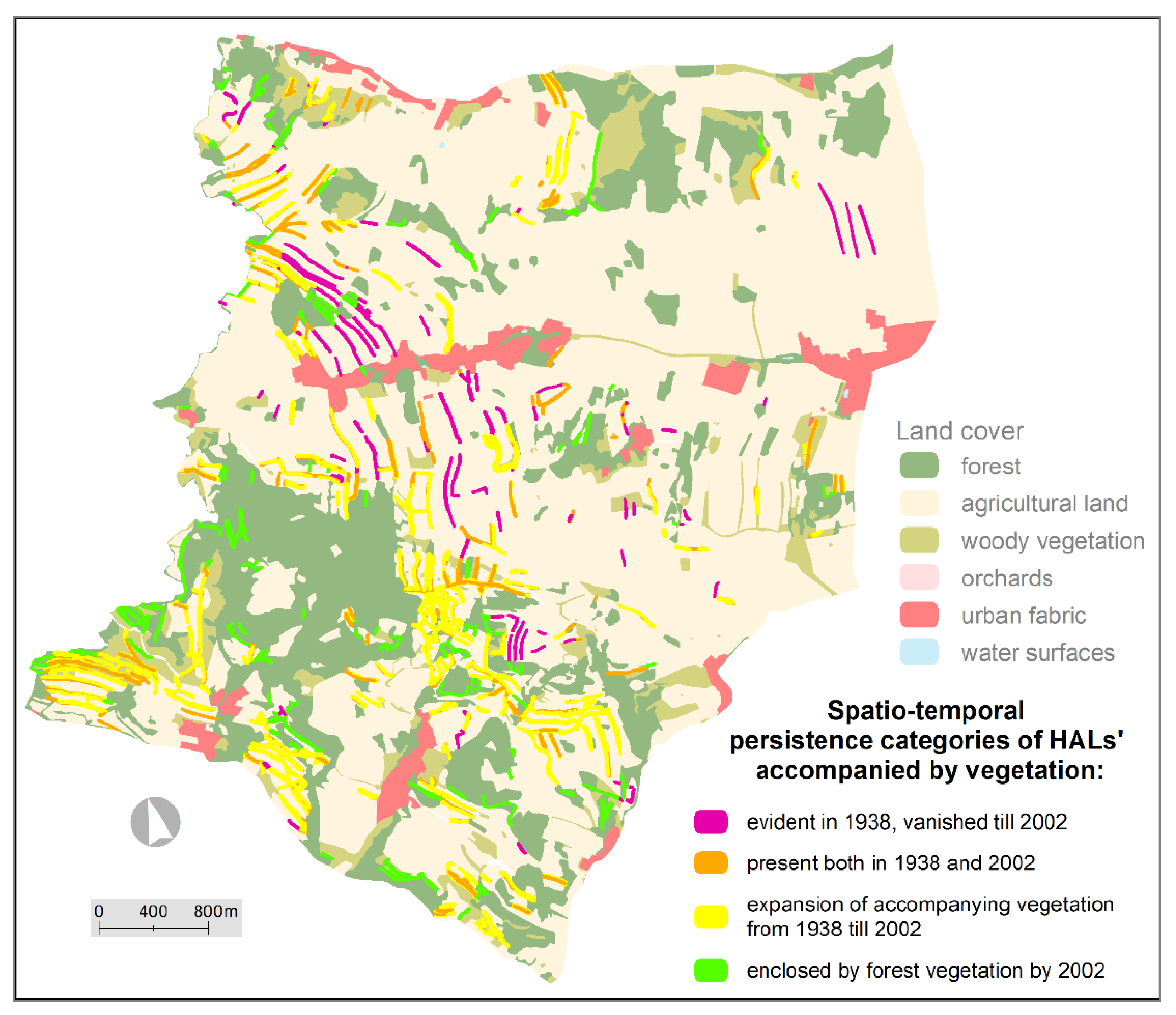
3.2. HALs Management Changes through Time

Maps of the Second Military Survey depict HALs as distinctly noticeable lines, as shown in Figure 6. Because the landforms are captured in the maps, their dimensions must have been visually significant in the landscape. Land-use of historical parcels in the first half of the 19th century varied, as is recorded in the Franciscan Cadastre. Parcels surrounding HALs were used as croplands, although the natural conditions at some sites could be considered harsh for farming. Parcels with HALs were recorded mostly as barren land, where stone accumulations limited farming, or as grasslands, with or without shrubs or trees (Figure 4 and Figure 7). The presence of signs of woody vegetation in maps is connected with coppicing, traditional practice of woodland management common until WWII.
A historical photograph of Heřmanovice village from the beginning of the 20th century (Figure 8) illustrates that stone walls and lynchets were partially covered by high-grown trees and shrubs. A hundred years ago, this woody linear vegetation visually dominated the scenery, and it was much more spatially distinctive than it is today. Forestry use of HAL parcels can also be noticed in old maps (Figure 7). The intensity of land-use varied regionally and was given, among the others, by natural conditions. The parcels’ spatial configuration is still preserved in some areas, although some HALs are already covered by natural woodland or forest plantation, due to either a lack of management or purposeful forestation (Figure 4 and Figure 7). The specific historical landscape pattern consisting of stone accumulations along field margins and risers with or without woody vegetation is noticeable in archive aerial imagery produced soon after WWII (Figure 5). At the former village of Mohelnice (Figure 5b), the linear stone accumulations apparent in the present-day orthophotograph can be tracked in historical imagery; in this case, the landforms were also accompanied by roads.

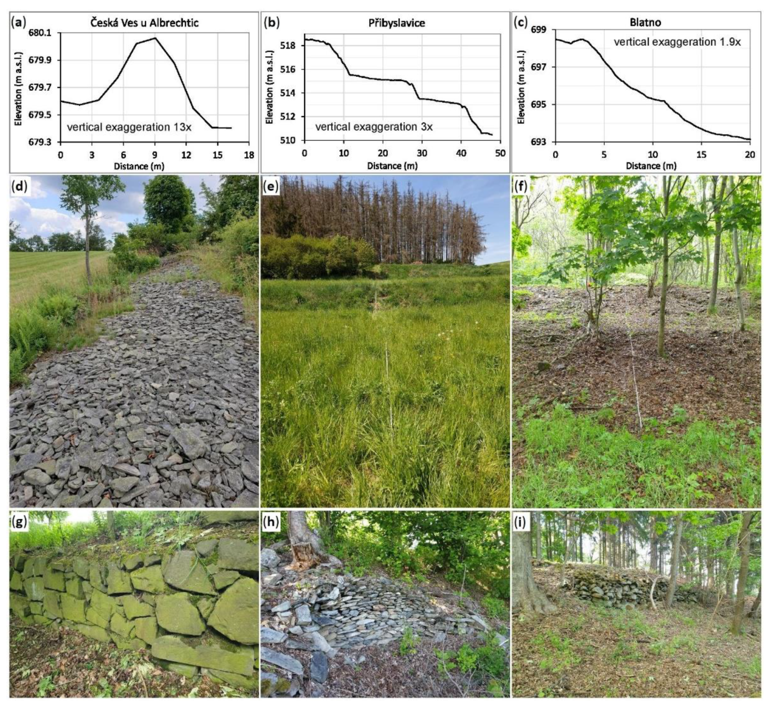
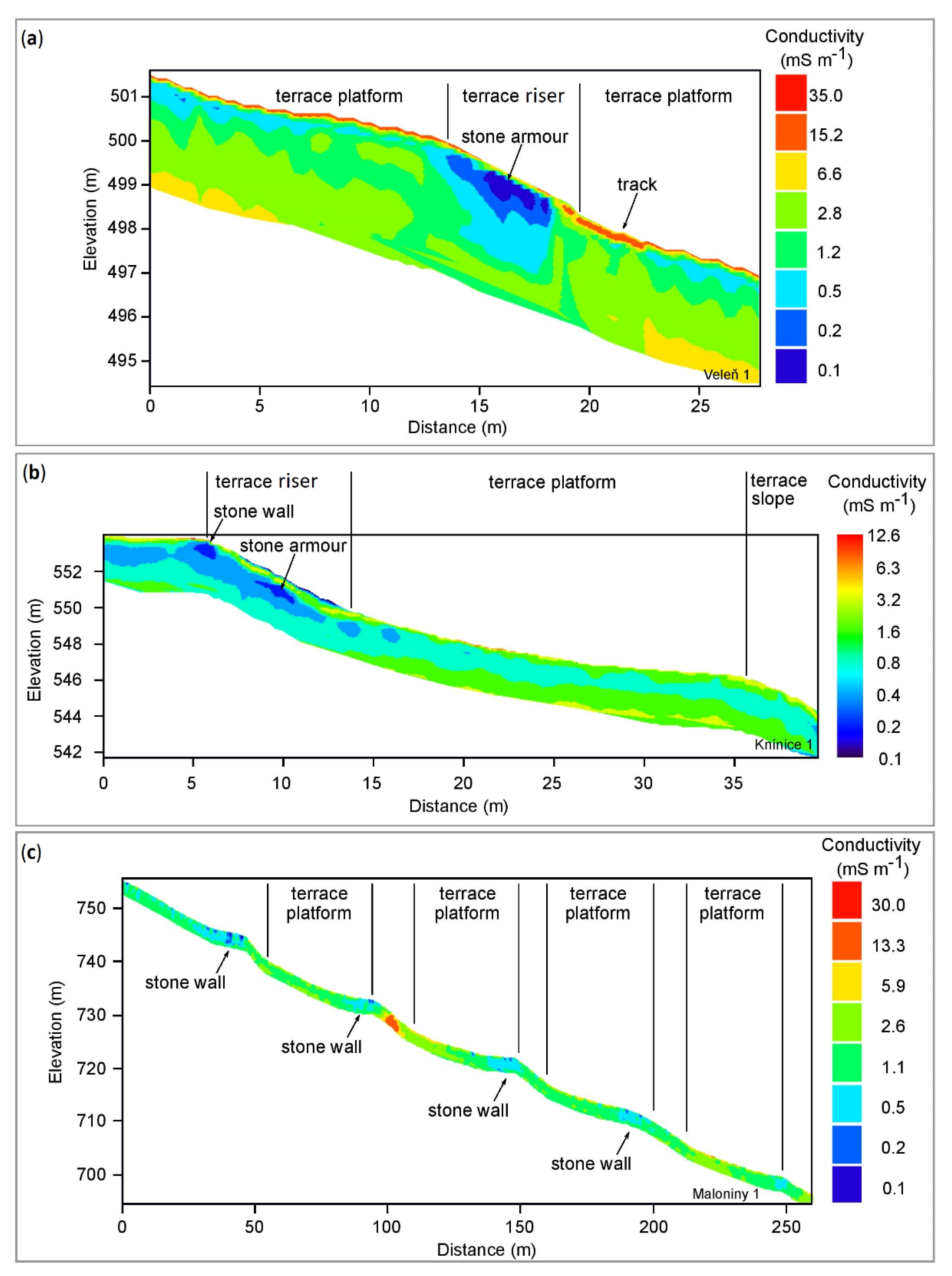
3.3. Effects of HALs on Secondary Geodiversity

We noted great variability of landforms during our field surveys. In some regions, piled or stacked stone walls were observed (Figure 9a,d), mostly at a higher elevation. The size and shape of stones in walls varied, among other things, depending on the local bedrock. These types of HALs were spotted generally in areas with a gentler slope, located not only along terrain contours, but also perpendicular to them. Besides walls, we focused on arrays of lynchets with diverse dimensions, depending on the inclination of the terrain. These HALs comprise soil lynchets (e.g., Figure 9b,e) and lynchets with stone accumulations on risers (Figure 9c,f). Historical roads can be noted in the exemplary cross-section of the Blatno site (Figure 9c). Additional stone walls (or their remnants) located on a farm road were also observed at other sites. Sections of preserved stacked stone walls were also found in some parts of risers (Figure 9g–i), with variable stone shapes. A stone wall at the study site Česká Ves u Města Albrechtic was 0.6 m high and 12 m wide (Figure 9a,d). At the Přibyslavice site, within an example of a lynchet array, the mean riser height is 2.2 m, while the mean width of the terrace platforms is 13 m (Figure 9b,e). The height of the riser with the farm road at the Blatno site is 5 m, and the width is 14 m (Figure 9c,f). The sites studied document variability in microtopography (see Figure 9). Long-term repeated tillage and water erosion resulted in soil translocation along the slope. A colluvium accumulates above the riser and gradually increases in height. Sites of lynchets with a considerable vertical difference in the riser were found during field surveys; for example, a 2.5 m high soil lynchet at Přibyslavice (Figure 9b) and a 3 m high lynchet with stones on the surface at Blatno (Figure 9c). Such steep downslope gradients were considerably decreased by the lynchets.
Soil translocation resulted in stepped slope gradients and long-term microrelief changes, which enabled farming on originally steep slopes. Figure 10 shows a typical elevation profile in the system of sub-parallel lynchets with field strips at the Maloniny site, with the parcels of terrace platforms oriented nearly perfectly along the contour lines. The difference between the actual and inferred original elevations is indicated by the grey line in Figure 10. The positive extremes of the elevation difference (~+1 m) show the positions of risers and stone walls, whereas the negative extremes (~−1 m) typically outline the middle parts of terraced platforms. The same pattern of elevation change in the downslope direction was observed in nearly all similarly examined plužiny. Lynchets considerably decreased the slope, in particular at the Maloniny site from ~10–15° to ~5–10°, the average slope on platforms decreased by 54%.
To document downslope soil transport, the grain-size distribution functions of topsoils (0–20 cm, fraction <2 mm) were examined at the three study sites. The fraction of particles <0.063 mm was generally large in the <2 mm portion at all three sites (60–90%, Figure 11). The expected results of long-term continuous tillage, including the downslope wash of the finest sand and finer material, which leaves coarser material (more sand) in the upper parts of the slope, were not observed irrespective of the considerable field slope. This can be interpreted as a lack of erosional transfer of the finest particles by a downslope wash. We did not find a smaller content of finer fractions on steeper slopes at any of the examined sites (Figure 11). Surprisingly, an opposite tendency was found at Velká Veleň after omitting two outlying samples (Figure 11b).
DEMP revealed high-resistivity subsurface domains (low conductivity, <1 mS m−1), which were composed mostly of stones on risers (Figure 12a,b), or in the lowermost part of terrace platforms (Figure 12c) or completely missing stones (the lower riser in Figure 12b). Terrace walls were commonly found at the former village of Maloniny (Figure 12c) and occasionally elsewhere (Figure 9g–i). The most conspicuous (steep and high) terrace walls were not subjected to DEMP because the presence of stones was obvious. In cases where the terrace walls were probably buried by pedosediment, DEMP was used to show the subsurface: vertically oriented domains with higher resistivity below the lower edges of the terrace platforms (Figure 12a,c) were indeed found as expected. Sub-horizontal, more resistive bodies were interpreted as stones covering the top of a rather common riser (Figure 12a) and stones in the upper part of the riser (Figure 12b). In some risers, the high-resistivity (stony) parts were practically missing. In places where the risers were cut by modern roads, we visually examined the materials of the riser in the field; a greater portion of the stone skeleton was indeed not found, as confirmed by our DEMP imaging. It is possible that their surface was stabilized only by vegetation.

3.4. Ecological Functions of HALs

Our analysis of the spatial variability of woody vegetation accompanying HALs within the region of Verneřice (Figure 13) showed that their presence is affected by certain favourable natural conditions. A decrease in land management intensity was noticed as woodlands spread spontaneously over HALs (15% of HALs was replaced by forestland after the depopulation of the region). Linear woody vegetation on stone walls and risers widened into strips overgrowing surrounding meadows in orthophotograph maps, accounting for 46% of the total area of the current woody vegetation patches. Only 8% of HALs persisted in the same shape, as in 1938, whereas 31% vanished completely. The amount of field boundaries with continuously present original vegetation and those apparently widened by vegetation spread is greater than the amount of those eliminated or replaced by forest. The persistence of woody vegetation on HALs for decades supports the substantial role of landscape elements. The local slope is an important factor for HALs as individual landscape elements. On gentler slopes, HALs were more likely to disappear as 7land was transformed into large agricultural parcels (see the northern part of the study region Figure 13). Conversely, land on steeper slopes was more likely to be abandoned, allowing the expansion of woody vegetation. The expansion of woody vegetation into former fields was noticed at many sites as farming pressure on the surrounding land decreased, so spontaneous succession proceeded rapidly (Figure 8 shows an example from Heřmanovice in the Jeseníky Mts).
The effect of HALs on species diversity was analysed on Oblík and Kohout hills by comparing the vascular plant communities of different habitats. At the Oblík and Kohout sites, 111 and 77 plant species were found, respectively (the full list of species from both sites can be found in Supplementary Material SC). At the Kohout site, only seven species were common to both the HALs and grasslands. In the case of Oblík Hill, nineteen species were common to both HALs and marginal habitats, sixteen were common to marginal and grassland habitats, and only four were common to HALs and adjacent grasslands. Based on the Jaccard similarity index, HAL and grassland habitats on Kohout Hill were only 22% similar. On Oblík Hill, the similarity in plant species composition between HALs and adjacent grassland was 10%, between HALs and marginal habitats, it was 38%, and between marginal and grassland habitats, it was 26%. For the detailed numbers of species in particular habitats, see Table 1. Oblík Hill has a high level of species diversity compared to Kohout Hill, which is mainly down to the warmer climate conditions of the former.
Two groups of invertebrate communities were selected as indicators of habitat diversity. Altogether, 91 species of spiders (1656 individuals) and 60 Carabidae species (709 individuals) were found at the Milešov site (full list in Supplementary Material SD). Based on the Bray–Curtis (dis)similarity index, we concluded that the Araneae species diversity was most similar between grasslands and HALs and differed more significantly between woodlands and grasslands or HALs. For Carabidae, the similarity was the highest between grasslands and HALs, whereas it was the lowest between forests and grasslands. The species diversity of spiders was highest in HAL habitats, whereas that of ground beetles was the highest in woodlands. The results are summarized in Table 1. Differences in the diversity of the two study groups of invertebrates can be attributed to variable behavior of species with respect to their movement through the landscape, variable habitat preferences, and/or stochastic errors in the sampling.

4. Discussion

Only local studies have been focused on the delimitation of HALs in Europe, for example [22,38,74]. Our study brings the first national map of stone walls and lynchets for a Central European country. The expert-based interpretation method applied can be assessed as quite reliable, with 75% of correctly interpreted landscape elements. Archive cartographic materials provide information on the persistence and management dynamics of HALs. These landscape elements can be considered stable in some areas, carrying landscape memory—legacy of our ancestors’ ability to sustainably farm their land. Evidence of coppicing, a traditional woodland management practice common until WWII, was found during our field surveys. Plužiny show some characteristics of European agroforestry systems with non-commercial but valuable roles, such as in increasing the fraction of semi-natural habitats, preventing of soil erosion, nutrient leaching and carbon sequestration associated with non-agroforestry landscapes [5,75].
Appropriate vegetation management on HALs could prevent the extinction of this phenomenon, which is a part of the natural and cultural heritage of the area [76].
The presence of the morphologically diverse HALs described above increases the local microtopographic diversity. As HALs have been created by long-term repeated tillage and water erosion, soil translocation along slopes was suspected at the Maloniny site (Figure 10). At the site the average slope on platforms decreased by 54% (the overall slope gradient being 0.24 m·m−1). The corresponding high variability of vertical differences within an array of lynchets was described in detail by [23] at a site in eastern Poland. Nyssen et al. [77] experimentally calculated the downward transport of soil at study sites in Ethiopia caused by non-mechanized tillage and applied their results to assess the age of lynchets in Belgium (Martelberg site). According to the calculations, the lynchets at the Martelberg site with platforms on average 45% less steep than the overall slope gradient (0.19 m·m−1) needed 217–585 years to be formed. When compared to the site of the Maloniny, studied here, the higher values of slope change correspond to a longer period of settlement. The Maloniny site was dated by Houfková et al. [12] to the end of the High Middle Ages (field margin organic material dated to the interval of 1154–1271 AD), allowing approximately 800 years for the lynchets to be formed. More archaeological studies dating HALs, such as Houfková et al. [12], would contribute to a better understanding of the origin of the plužina phenomenon.
A homogeneous content of fine sediment components of several terrace platforms, irrespective of the considerable slopes (Figure 11), does not necessarily mean a lack of downslope erosion. It could also result from soil management. In the 19th century and the first half of the 20th century, intentional manual upslope transfers of soils, after intense rainfalls with considerable downslope soil transport, were documented [78]. Such simple management could contribute considerably to farming sustainability on steep slopes. Although the phenomenon of downslope wash of finer soil material could not be observed at our study sites, the process of leaving behind coarse debris in the upper parts of severely degraded fields was documented by Latocha [35]. Klimek and Latocha [79] reported another example of fields belonging to former montane villages in the Polish Sudetes, mostly with highly erodible bedrock, where terrace walls were constructed several centuries after the foundation of the villages. Horák et al. [80] provided an example of a medieval village in Central Bohemia (Czechia), named Lovětín, which was reportedly deserted because of inadequate soil management. Nevertheless, dating HALs has shown that plužiny could provide sustainable farming in extremely marginal conditions with respect to modern requirements for agriculture [12]. Our findings show that sustainability was not limited to exceptional sites, but was quite widespread; modern lack of care endangers them actually more seriously than their past agricultural use.
Regarding the types of lynchets based on their characteristics, this research employed a simplified categorization of these landforms, as stones were not detectable right under the soil surface in all areas: soil lynchets, soil lynchets with stones on the riser, and stony lynchets. Špulerová et al. [81], using a different terminology based on the soil skeleton content, distinguished between soil terraces, soil terraces with stones, stony terraces with soil on the top, and stony terraces. Stony terraces with soil at the top can be distinguished by surveying the riser inner structure using geophysical imaging (Figure 12). To date, the DEMP method has not been applied for this purpose, but it is promising for the differentiation of soil lynchets and lynchets with stones on the riser, irrespective of whether they are buried. DEMP can be recommended for detailed studies of individual HALs to replace destructive investigation of the inner structure of these landforms, as practised by Houfková et al. [12] or Šitnerová et al. [27].
The facts presented above support the notion that HALs increase landscape geodiversity. Gray [82] recognized, inter alia, the functional value of geodiversity, stating that geodiversity creates biodiversity. The same idea is applicable to the secondary geodiversity induced in the landscape by people [83]. HALs are exemplary cases of valuable secondary geodiversity, providing increasingly important ecosystem services, as noted by Brown et al. [84].
Based on our study of the diversity of plants and invertebrates among habitats, we can state that the presence of HALs increases landscape, habitat, and species diversity. The small-scale mosaic of various HAL habitats with diversified vegetation acts as a local pool of biodiversity at the landscape level in contrast to unified landscapes of modern intensive agriculture or forestry. The same conclusion was reached by Špulerová et al. [81]. The diversity of plant and invertebrate species is greater in landscapes with HALs than in those without them. The diversity brought by HALs provides habitats for species that are threatened by agri- and silvicultural practices, which became predominant in the 20th century, such as production-oriented spruce forest planting and increasing crop yield even at the cost of soil degradation, involving the use of heavy machinery and agrochemicals.
Stone screes (disintegrated HALs) or vertical stone walls, shrubby vegetation formations and woody stands with enclosed shady interiors of linear vegetation can all be observed on HALs. Depending on the natural conditions, most HALs are accompanied by woody vegetation in the form of hedgerows, as outlined above. Linear woody vegetation along HALs mitigates the adverse effects of climate change through its ability to decrease evapotranspiration, moderate microclimate, and sequester carbon [41,75]. In addition, the high level of landscape heterogeneity and connectivity provided by linear landscape elements supports the stability, flow, and delivery of biodiversity-based ecosystem services [85], in general, supporting landscape functioning [47]. Hedgerows accompanying HALs can significantly contribute to these functions.
The major process of HAL vegetation cover disintegration is land abandonment accompanied by subsequent spontaneous succession (Figure 7 and Figure 13) and occasionally purposeful forestation. Natural succession has led to the spontaneous development of woody stands close to the climax state, with typical broad-leaved tree species. For example, during field observations in the Verneřice region, we found expected species such as the common hornbeam (Carpinus betulus), sessile oak (Quercus petraea), or common oak (Quercus robur). Latocha et al. [3] also noted that deciduous trees prevail in such structures. Thus, in present-day upland and highland landscapes, HALs can be observed as clearly discernible green islets within the “industrial” forests planted during the last few centuries during which the dominant species, European spruce (Picea abies), was repeatedly severely damaged by bark-beetle outbreaks throughout Czechia (e.g., Figure 9e and Figure 14) and elsewhere in Europe [86], the most recent of which has occurred in the last few years. In some areas during our fieldwork, the only living trees were actually the remaining broad-leaved vegetation on HALs. These landforms with their vegetation cover, therefore, fulfil many more functions in the landscape than foreseen by their creators, which makes them valuable also because a lack of local wood is expected in the upcoming years and decades.
On the other hand, landforms left to be overgrown by woody vegetation are destined for gradual destruction. Despite being replaced by woodland or affected by land cover/use change, remnants of original landforms persist on some sites; therefore, stone walls, piles, and lynchets can still be found even in forests (Figure 7 and Figure 13; [37]). Moreover, imprints of former HALs can remain in the soil at sites where they have been damaged [87]. The existence of past HALs may also be reflected by local vegetation communities, as described by Latocha et al. [8].
HALs have suffered damage by human activities because of a lack of awareness of their value. They are being destroyed during logging activities in the context of the recent bark-beetle outbreak and the removal of large amounts of dead wood from former plantations (common in the Jeseníky Mts). HALs are sometimes destroyed for the creation of new infrastructure. For example, a main road intersects an array of well-preserved lynchets near Knínice (in the Krušné Hory Mts, Figure 4b), and a ski slope runs through another array of lynchets near Vrbno pod Pradědem (Jeseníky Mts) with a water reservoir for snowmaking and a bobsleigh track placed on the lynchets (Figure 15). Sklenička et al. [14] found that the surrounding land-use type, land tenure security, and local legal restrictions have been important drivers behind the recent disappearance or persistence of plužiny. Certain agricultural subsidies can limit agricultural land abandonment and thus promote the persistence of plužiny [14,88]. The land use of adjacent parcels is, of course, an important factor in HALs conservation as well [23]. In border regions of Czechia with a high concentration of HALs, large-scale organic farming predominates (field observations and [89]). The surrounding parcels are managed by hay-making and grazing, which prevents successional overgrowth by shrubby vegetation. The positive effect of this kind of management on the landscape is indisputable. However, many HALs are located at the edges of or inside grazing complexes. Cattle cause damage to the vegetation structures on HALs, especially to herbaceous vegetation. Sometimes even the stone accumulations are disrupted by cattle. These effects of pasture proximity were documented by Weber [90] in Northern Germany, Riezner [91] in the Jeseníky Mts, and Machová [92] in the České Středohoří Mts.
Although HALs diversify landscape mosaics and increase secondary geodiversity, they do not have any explicit legal protection status in Czechia, so their future is threatened by human activities/passivity. In Saxony, Germany, a special habitat category for one type of HALs focuses on the specific flora linked to the landforms. Because of their anthropogenic origin, HALs are generally not considered valuable by local environmental groups. Only a small portion of protected areas treat HALs as objects of interest, although HALs fulfil the geomorphological, aesthetic, cultural, and ecological criteria needed to merit protection. As noted above, the effect of HALs on landscape character deserves to be acknowledged by including plužiny and individual HALs under areas protected by national law. In general, visually valuable landscapes under protection generally tend to attract tourism. Conservation efforts and the economic development of protected areas are promoted, but the sustainability of this approach to conservation is questionable [93]. Heritage-focussed planning mostly prioritizes tourism, as practised, for example, in Greece, which is regarded as insufficient for creating future sustainable landscapes [94].
Based on the information above, we opine that HALs are valuable and should be protected. Their conservation can be supported by their inclusion in protected areas, especially in regions with a high density of these landscape features. This corresponds with the European Biodiversity Strategy for 2030 [95], aimed to halt biodiversity decline and to establish protected areas on 30% of land in Europe during this decade. At the level of individual HALs, the best way to prevent their destruction and acknowledge their manifold beneficial roles in the landscape would be targeted support motivating farmers to register HALs with their vegetation cover as landscape features within ecological focus areas through the Common Agricultural Policy.

5. Conclusions

Plužiny and their components (HALs) have positive effects on present-day rural landscapes. Based on a literature review and our research, we conclude that HALs increase biodiversity. Mosaics with plenty of bio-corridors contribute to the ecological resilience of the landscape while still facilitating agriculture in marginal areas. Arrays of terraces provide numerous benefits for future landscapes threatened by expected seasonal extremes in precipitation in Europe, caused by climate change. Terraces limit soil erosion during heavy rain and improve water retention. Woody vegetation on landforms also plays an indispensable role in the microclimate, which is particularly relevant with respect to the ongoing decline of coniferous forests. HALs are a substantial part of the secondary geodiversity of historical landscapes. As elements of landscape memory, they carry a legacy of our ancestors and their centuries-long farming efforts, which have been imprinted into persistent and aesthetically valuable landforms (namely, the distinctive spatial configuration of plužiny parcels). Their heritage and archaeological value are yet to be fully acknowledged, as they are man-made landscape elements. This, however, does not diminish their value. The majority of Central European landscapes are altered by humans, and plužiny are examples of beneficial anthropogenic modifications which are valuable as a bio-cultural heritage. Although plužiny are still locally quite abundant (especially in the border mountain regions of Czechia), they will gradually disappear unless they are given a certain level of protection and targeted management. These landscape features should be included in new protected areas expected to be established by 2030, as their legacy of sustainability can provide valuable lessons for future landscape management.

Supplementary Materials

The following supporting information can be downloaded at: https://0-www-mdpi-com.brum.beds.ac.uk/article/10.3390/land11070963/s1, Supplementary Materials: SA—study sites of the research (KMZ file); SB—examples of the interpretation of input materials by Mazáková [68]; SC—species diversity of plants in the landscape with present historical agricultural landforms; SD—species diversity and quantity of invertebrate communities in landscapes with the presence of historical agricultural landforms.

Author Contributions

Conceptualization, J.Z., I.M. and T.M.G.; data curation, J.Z., J.E., I.M., J.P., J.Š. and T.M.G.; formal analysis, J.Z., J.E., D.H. and T.M.G.; funding acquisition, J.Z. and J.E.; investigation, J.Z., J.E., I.M., K.K., D.H., M.H. and T.M.G.; project administration, J.E.; supervision, J.E. and T.M.G.; validation, J.Z., J.E., I.M. and T.M.G.; visualization, J.Z., J.E. and T.M.G.; writing—original draft, J.Z., J.R. and T.M.G.; writing—review and editing, J.Z., J.R., J.E., I.M., K.K., D.H., M.H. and T.M.G. All authors have read and agreed to the published version of the manuscript.

Funding

This research was funded by the Internal Grant Agency of J. E. Purkyně University in Ústí nad Labem (UJEP), grant numbers UJEP-IGA-TC-2019-44-02-2 (data acquisition and processing) and UJEP-IGA-JR-2021-44-006-02 (research outputs finalization).

Institutional Review Board Statement

Not applicable.

Informed Consent Statement

Not applicable.

Data Availability Statement

The data presented in this study are available on request from the corresponding author.

Acknowledgments

The authors thank E. Mazáková for her primary input into HAL database as part of her Master’s thesis.

Conflicts of Interest

The authors declare no conflict of interest.

References

  1. Filippo, B.; Cremaschi, M.; Manuela, P. Estimating the Potential of Archaeo-historical Data in the Definition of Geomorphosites and Geo-educational Itineraries in the Central Po Plain (N Italy). Geoheritage 2019, 11, 1371–1396. [Google Scholar] [CrossRef]
  2. Fisher, C. Archaeology for Sustainable Agriculture. J. Archaeol. Res. 2020, 28, 393–441. [Google Scholar] [CrossRef]
  3. Turner, S.; Kinnaird, T.; Koparal, E.; Lekakis, S.; Sevara, C. Landscape archaeology, sustainability and the necessity of change. World Archaeol. 2020, 52, 589–606. [Google Scholar] [CrossRef]
  4. Montanarella, L.; Panagos, P. The relevance of sustainable soil management within the European Green Deal. Land Use Policy 2021, 100, 104950. [Google Scholar] [CrossRef]
  5. Kay, S.; Crous-Duran, J.; Ferreiro-Domínguez, N.; de Jalón, S.G.; Graves, A.; Moreno, G.; Mosquera-Losada, M.R.; Palma, J.H.N.; Roces-Díaz, J.V.; Santiago-Freijanes, J.J.; et al. Spatial similarities between European agroforestry systems and ecosystem services at the landscape scale. Agrofor. Syst. 2018, 92, 1075–1089. [Google Scholar] [CrossRef] [Green Version]
  6. Brabec, E.; Molnárová, K. Pluzina: The Issues of Documenting a Vernacular Landscape; Landscape Architecture & Regional Planning Faculty Publication Series; 2010; Volume 61. Available online: https://scholarworks.umass.edu/larp_faculty_pubs/61 (accessed on 21 October 2020).
  7. Lieskovský, J.; Bürgi, M. Persistence in cultural landscapes: A pan-European analysis. Reg. Environ. Chang. 2018, 18, 175–187. [Google Scholar] [CrossRef]
  8. Latocha, A.; Reczyńska, K.; Gradowski, T.; Świerkosz, K. Landscape memory in abandoned areas—physical and ecological perspectives (Central European mountains case study). Landsc. Res. 2019, 44, 600–613. [Google Scholar] [CrossRef]
  9. Uhlig, H.; Lienau, C. Die Siedlungen des ländlichen Raumes. In Materialien zur Terminologie der Agrarlandschaft, 2nd ed.; Lenz-Verlag: Giessen, Germany, 1972; p. 410. (In German) [Google Scholar]
  10. Láznička, Z. Typy Venkovského Osídlení V Československu; Československá akademie věd, Práce brněnské základny Československé akademie věd: Prague, Czechia, 1956; p. 95. (In Czech) [Google Scholar]
  11. Erný, E. Zaniklé Středověké Osady a Jejich Plužiny: Metodika Historicko-Geografického Výzkumu V Oblasti Drahanské Vrchoviny, 1st ed.; Academia: Prague, Czechia, 1979; p. 167. (In Czech) [Google Scholar]
  12. Houfková, P.; Bumerl, J.; Pospíšil, L.; Karlík, P.; Beneš, J.; Bernardová, A.; Hrabalíková, M.; Molnárová, K.J.; Hejcman, M. Origin and development of long-strip field patterns: A case study of an abandoned medieval village in the Czech Republic. CATENA 2015, 135, 83–91. [Google Scholar] [CrossRef]
  13. Sklenicka, P.; Molnarová, K.J.; Brabec, E.; Kumble, P.; Pittnerova, B.; Pixova, K.; Salek, M. Remnants of medieval field patterns in the Czech Republic: Analysis of driving forces behind their disappearance with special attention to the role of hedgerows. Agric. Ecosyst. Environ. 2009, 129, 465–473. [Google Scholar] [CrossRef] [Green Version]
  14. Sklenicka, P.; Kottová, B.; Šálek, M. Success in preserving historic rural landscapes under various policy measures: Incentives, restrictions or planning? Environ. Sci. Policy 2017, 75, 1–9. [Google Scholar] [CrossRef]
  15. Šitnerová, I.; Beneš, J.; Kottová, B.; Bumerl, J.; Majerovičová, T.; Janečková, K. Archaeological research into field systems and agrarian terraces as the phenomena of the historical landscape in the Czech Republic. Archaeol. Hist. 2020, 45, 141–165. [Google Scholar] [CrossRef]
  16. Kuna, M.; Beneš, M.; Drelerová, D.; Gojda, M.; Hrubý, P.; Křivánek, R.; Majer, A.; Prach, K.; Tomášek, M. Nedestruktivní Archeologie—Teorie, Metody a Cíle; Academia, Czech Academy of Science: Prague, Czechia, 2014; p. 555. (In Czech) [Google Scholar]
  17. Löw, J.; Míchal, I. Krajinný Ráz, 1st ed.; Lesnická Práce: Kostelec nad Černými Lesy, Czechia, 2003; p. 552. (In Czech) [Google Scholar]
  18. Gojda, M. Archeologie Krajiny; Academia: Prague, Czechia, 2000; p. 238. (In Czech) [Google Scholar]
  19. Lipský, Z. Sledování Změn V Kulturní Krajině; Czech University of Life Sciences Prague: Prague, Czechia, 2000; p. 71. (In Czech) [Google Scholar]
  20. Bičík, I.; Kabrda, J. Land use changes in Czech border regions (1845–2000). Acta Univ. Carol. Geogr. 2007, 42, 23–52. [Google Scholar]
  21. Lieskovský, J.; Kenderessy, P.; Špulerová, J.; Lieskovský, T.; Koleda, P.; Kienast, F.; Gimmi, U. Factors affecting the persistence of traditional agricultural landscapes in Slovakia during the collectivization of agriculture. Landsc. Ecol. 2014, 29, 867–877. [Google Scholar] [CrossRef] [Green Version]
  22. Molnárová, K. Hedgerow-Defined Medieval Field Patterns in the Czech Republic and Their Conservation. Ph.D. Thesis, Czech University of Life Sciences Prague, Prague, Czechia, 2008; p. 100. [Google Scholar]
  23. Patro, M.; Węgorek, T.; Zubala, T. Ploughed-on terraces in loess landscape of strongly developed high plains. Ann. Wars. Univ. Life Sci. SGGW. Land Reclam. 2008, 39, 95–101. [Google Scholar] [CrossRef]
  24. Riezner, J. Krajinný ráz území typických agrárními valy a mezemi a jejich vegetací na vybraných příkladech ze Severozápadních Čech. Studia Oecologica 2011, 5, 65–79. (In Czech) [Google Scholar]
  25. Slamova, M.; Jančura, P.; Danis, D. Methods of Historical Landscape Structures Identification and Implementation into Landscape Studies. Ekológia 2013, 32, 267–276. [Google Scholar] [CrossRef] [Green Version]
  26. Kovář, P.; Bačinová, H.; Loula, J.; Fedorova, D. Use of terraces to mitigate the impacts of overland flow and erosion on a catchment. Plant Soil Environ. 2016, 62, 171–177. [Google Scholar] [CrossRef] [Green Version]
  27. Šitnerová, I.; Beneš, J.; Trpáková, I.; Bumerl, J.; Komárková, V.; Majerovičová, T.; Hrabáková, L.; Janečková, K. Landscape Transformed: Archaeological, Historical and Environmental Dating of the Early Modern Field System in Valštejn, Czech Republic. Interdiscip. Archaeol. Nat. Sci. Archaeol. 2020, 11, 89–101. [Google Scholar] [CrossRef]
  28. Latocha, A.; Reczyńska, K.; Świerkosz, K.; Gradowski, T. Geomorphological and ecological persistence of traces of past settlement—An example of Karpno village in the Złote Mts (Eastern Sudetes). Przyr. Sudet. 2021, 23, 223–240. (In Polish) [Google Scholar]
  29. Houben, P. Scale linkage and contingency effects of field-scale and hillslope-scale controls of long-term soil erosion: Anthropogeomorphic sediment flux in agricultural loess watersheds of Southern Germany. Geomorphology 2008, 101, 172–191. [Google Scholar] [CrossRef]
  30. Oshunsanya, S. Spacing effects of vetiver grass (Vetiveria nigritana Stapf) hedgerows on soil accumulation and yields of maize–cassava intercropping system in Southwest Nigeria. CATENA 2013, 104, 120–126. [Google Scholar] [CrossRef]
  31. Bayer, T.; Beneš, J. Medieval terraced fields in the Bohemian Forest as a hydropedological phenomenon and problem of landscape archaeology [Středověká terasová pole na Šumavě jako hydropedologický fenomén a archeologický problém]. Arch Rozhl. 2004, 56, 139–159. (In Czech) [Google Scholar]
  32. Kovář, P.; Vaššová, D.; Hrabalíková, M. Mitigation of surface runoff and erosion impacts on catchment by stone hedgerows. Soil Water Res. 2011, 6, 153–164. [Google Scholar] [CrossRef] [Green Version]
  33. Seeger, M.; Ries, J.B. Soil degradation and soil surface process intensities on abandoned fields in Mediterranean mountain environments. Land Degrad. Dev. 2008, 19, 488–501. [Google Scholar] [CrossRef]
  34. Goodman-Elgar, M. Evaluating soil resilience in long-term cultivation: A study of pre-Columbian terraces from the Paca Valley, Peru. J. Archaeol. Sci. 2008, 35, 3072–3086. [Google Scholar] [CrossRef]
  35. Latocha, A. Przemainy Środowiska Przyrodniczego W Sudetach Wschodnich W Warunkach Antropopresji; Wydawnictwo Uniwersytetu Wroclawskiego: Wroclaw, Poland, 2007; p. 215. [Google Scholar]
  36. Latocha, A. Geomorphic connectivity within abandoned small catchments (Stołowe Mts, SW Poland). Geomorphology 2014, 212, 4–15. [Google Scholar] [CrossRef]
  37. Affek, A. Past Carpathian landscapes recorded in the microtopography. Geogr. Pol. 2016, 89, 415–424. [Google Scholar] [CrossRef]
  38. Duma, P.; Latocha, A.; Łuczak, A.; Piekalski, J. Stone Walls as a Characteristic Feature of the Cultural Landscape of the Izera Mountains, southwestern Poland. Int. J. Hist. Archaeol. 2020, 24, 22–43. [Google Scholar] [CrossRef] [Green Version]
  39. Chartin, C.; Bourennane, H.; Salvador-Blanes, S.; Hinschberger, F.; Macaire, J.-J. Classification and mapping of anthropogenic landforms on cultivated hillslopes using DEMs and soil thickness data—Example from the SW Parisian Basin, France. Geomorphology 2011, 135, 8–20. [Google Scholar] [CrossRef] [Green Version]
  40. Froehlicher, L.; Schwartz, D.; Ertlen, D.; Trautmann, M. Hedges, colluvium and lynchets along a reference toposequence (Habsheim, Alsace, France): History of erosion in a loess area. Quaternaire 2016, 27, 173–185. [Google Scholar] [CrossRef] [Green Version]
  41. Montgomery, I.; Caruso, T.; Reid, N. Hedgerows as Ecosystems: Service Delivery, Management, and Restoration. Annu. Rev. Ecol. Evol. Syst. 2020, 51, 81–102. [Google Scholar] [CrossRef]
  42. Gil-Tena, A.; De Cáceres, M.; Ernoult, A.; Butet, A.; Brotons, L.; Burel, F. Agricultural landscape composition as a driver of farmland bird diversity in Brittany (NW France). Agric. Ecosyst. Environ. 2015, 205, 79–89. [Google Scholar] [CrossRef]
  43. Pelletier-Guittier, C.; Théau, J.; Dupras, J. Use of hedgerows by mammals in an intensive agricultural landscape. Agric. Ecosyst. Environ. 2020, 302, 107079. [Google Scholar] [CrossRef]
  44. Tschumi, M.; Birkhofer, K.; Blasiusson, S.; Jörgensen, M.; Smith, H.G.; Ekroos, J. Woody elements benefit bird diversity to a larger extent than semi-natural grasslands in cereal-dominated landscapes. Basic Appl. Ecol. 2020, 46, 15–23. [Google Scholar] [CrossRef]
  45. Dover, J.W. (Ed.) The Ecology of Hedgerows and Field Margins; Routledge: London, UK, 2019; p. 306. [Google Scholar]
  46. Poschlod, P.; Braun-Reichert, R. Small natural features with large ecological roles in ancient agricultural landscapes of Central Europe—History, value, status, and conservation. Biol. Conserv. 2017, 211, 60–68. [Google Scholar] [CrossRef]
  47. Forman, R.T.T.; Godron, M. Landscape Ecology; John Wiley: New York, NY, USA, 1986; p. 619. [Google Scholar]
  48. Ucar, T.; Hall, F.R. Windbreaks as a pesticide drift mitigation strategy: A review. Pest Manag. Sci. 2001, 57, 663–675. [Google Scholar] [CrossRef]
  49. Marshall, E.; Moonen, A. Field margins in northern Europe: Their functions and interactions with agriculture. Agric. Ecosyst. Environ. 2002, 89, 5–21. [Google Scholar] [CrossRef]
  50. Council of Europe. European Landscape Convention; European Treaty Series, No. 176; Council of Europe: Florence, Italy, 2000; p. 7. [Google Scholar]
  51. Henkel, G. Kann die überlieferte Kulturlandschaft ein Leitbild für die Planung sein? Ber. Zur Dtsch. Landeskd. 1997, 71, 27–37. (In German) [Google Scholar]
  52. Wöbse, H.H. Kulturlandschaft und historische Kulturlandschaft. Inf. Zur Raumentwickl. 1999, 26, 269–278. (In German) [Google Scholar]
  53. Schama, S. Landscape and Memory; Vintage: New York, NY, USA, 1995; p. 652. [Google Scholar]
  54. Špulerová, J.; Dobrovodská, M.; Lieskovský, J.; Baca, A.; Halabuk, A.; Kohut, F.; Mojses, M.; Kenderessy, P.; Piscová, V.; Barančok, P.; et al. Inventory and classification of historical structures of the agricultural landscape in Slovakia. Ekológia 2011, 30, 157–170. [Google Scholar] [CrossRef]
  55. Špulerová, J.; Bezák, P.; Dobrovodská, M.; Lieskovský, J.; Štefunková, D. Traditional agricultural landscapes in Slovakia: Why should we preserve them? Landsc. Res. 2017, 42, 891–903. [Google Scholar] [CrossRef]
  56. Burel, F.; Baudry, J. Social, aesthetic and ecological aspects of hedgerows in rural landscapes as a framework for greenways. Landsc. Urban Plan. 1995, 33, 327–340. [Google Scholar] [CrossRef]
  57. Slámová, M. Význam Historických Krajinných Štruktúr Turca Pri Posudzovaní Kvality Krajinného Obrazu [Value of Historical Landscape Structures of Turiec for Landscape Quality Assesment]. In Vybrané Problémy Tvorby Krajiny [Selected Issues of Landscape Planning]; Daniš, D., Jančura, P., Eds.; Janka Čižmárová—Partner: Banská Bystrica, Slovakia, 2007; pp. 56–61. (In Slovak) [Google Scholar]
  58. Meeus, J. Pan-European landscapes. Landsc. Urban Plan. 1995, 31, 57–79. [Google Scholar] [CrossRef]
  59. van der Zanden, E.H.; Levers, C.; Verburg, P.H.; Kuemmerle, T. Representing composition, spatial structure and management intensity of European agricultural landscapes: A new typology. Landsc. Urban Plan. 2016, 150, 36–49. [Google Scholar] [CrossRef]
  60. van der Zanden, E.H.; Verburg, P.; Mucher, S. Modelling the spatial distribution of linear landscape elements in Europe. Ecol. Indic. 2013, 27, 125–136. [Google Scholar] [CrossRef]
  61. Rotherham, I. Bio-cultural heritage and biodiversity: Emerging paradigms in conservation and planning. Biodivers. Conserv. 2015, 24, 3405–3429. [Google Scholar] [CrossRef] [Green Version]
  62. Ernst, L.M.; Tscharntke, T.; Batáry, P. Grassland management in agricultural vs. forested landscapes drives butterfly and bird diversity. Biol. Conserv. 2017, 216, 51–59. [Google Scholar] [CrossRef] [Green Version]
  63. van der Zanden, E.H.; Carvalho-Ribeiro, S.M.; Verburg, P.H. Abandonment landscapes: User attitudes, alternative futures and land management in Castro Laboreiro, Portugal. Reg. Environ. Chang. 2018, 18, 1509–1520. [Google Scholar] [CrossRef] [Green Version]
  64. Walczak, C.; Machová, I.; Müller, F.; Kubát, K. Lesesteinwälle Im Sachsich-Böhmishen Erzgebirge/Agrární Valy A Terasy Na České a Saské Straně Krušných Hor; Technical University in Dresden, Dresden, Germany, J.E. Purkyně University in Ústí nad Labem, Ústí nad Labem, Czechia; Naturschutzinstitut Freiberg: Freiberg, Germany, 2021; p. 140. [Google Scholar]
  65. Fink, P.; Heinze, S.; Raths, U.; Riecken, U.; Ssymank, A. Rote Liste der Gefährdeten Biotoptypen Deutschlands; Naturschutz und Biologische Vielfalt; No. 156; Landwirtschaftsverlag: Bad Godesberg, Germany, 2017; p. 637. (In German) [Google Scholar]
  66. Grunewald, K.; Syrbe, R.-U. Bilanzierung von Ausgewählten Leistungen und Anforderungen der Landschaftspflege in Sachsen Aus Landesweiter Sicht; Schriftenreihe des Landesamtes für Umwelt, Landwirtschaft und Geologie; No. 17; Landesamt für Umwelt, Landwirtschaft und Geologie: Sachsen, Germany, 2013; p. 208, (In German). Available online: https://publikationen.sachsen.de/bdb/artikel/15185/documents/25979 (accessed on 29 March 2022). (In German)
  67. Representation of Formation Groups of Natural Habitats in the Czech Republic—Web Map App of Nature Conservation Agency of the Czech Republic, 2nd ed.; Chytrý, M.; Kučera, T.; Kočí, M. (Eds.) Catalog of habitats of the Czech Republic; Agency for Nature and Landscape Protection of the Czech Republic: Prague, Czechia, 2010; p. 445. Available online: https://aopkcr.maps.arcgis.com/apps/webappviewer/index.html?id=c38db59779714a78aec4c731152b0290 (accessed on 21 October 2021).
  68. Mazáková, E. Rozšíření Agrárních Valů a Teras Na Území Čech. Master’s Thesis, J.E. Purkyně University in Ústí nad Labem, Ústí nad Labem, Czechia, 2019; p. 100. [Google Scholar]
  69. Cajthaml, J.; Pacina, J. Old Maps as a Source of Landscape Changes—Georeferencing, Accuracy and Error Detection. In Proceedings of the 15th International Multidisciplinary Scientific GeoConference SGEM, Albena, Bulgaria, 18–24 June 2015; Volume 2. [Google Scholar] [CrossRef]
  70. Jaccard, P. The distribution of the flora in the alpine zone.1. New Phytol. 1912, 11, 37–50. [Google Scholar] [CrossRef]
  71. Krebs, C.H.J. Ecological Methodology; Benjamin/Cummings, Californian University: Los Angeles, CA, USA, 1999; p. 620. [Google Scholar]
  72. MAPIRE. Arcanum Maps—The Historical Map Portal. Available online: https://maps.arcanum.com/en/ (accessed on 28 March 2020).
  73. Biszak, E.; Biszak, S.; Timár, G.; Nagy, D.; Molnár, G. Historical topographic and cadastral maps of Europe in spotlight—Evolution of the MAPIRE web portal. In Proceedings of the 12th ICA Conference Digital Approaches to Cartographic Heritage, Venice, Italy, 26–28 April 2017. [Google Scholar]
  74. Sobala, M. Do historical maps show the maximal anthropopressure in the Carpathians? J. Mt. Sci. 2021, 18, 2184–2200. [Google Scholar] [CrossRef]
  75. Van Den Berge, S.; Vangansbeke, P.; Baeten, L.; Vanneste, T.; Vos, F.; Verheyen, K. Soil carbon of hedgerows and ‘ghost’ hedgerows. Agrofor. Syst. 2021, 95, 1087–1103. [Google Scholar] [CrossRef]
  76. Buček, A.; Černušáková, L.; Friedl, M.; Machala, M.; Maděra, P. Ancient Coppice Woodlands in the Landscape of the Czech Republic. Eur. Countrys. 2017, 9, 617–646. [Google Scholar] [CrossRef] [Green Version]
  77. Nyssen, J.; Debever, M.; Poesen, J.; Deckers, J. Lynchets in eastern Belgium—A geomorphic feature resulting from non-mechanised crop farming. CATENA 2014, 121, 164–175. [Google Scholar] [CrossRef] [Green Version]
  78. Riezner, J. Adaptace historických agrárních komunit na přírodní podmínky horských oblastí v Českých zemích. In Adaptabilita a Resilience: Studie k Integrujícím Přístupům V Geografickém Výzkumu; Raška, P., Hruška, V., Anděl, J., Balej, M., Bláha, J.D., Kučerová, S.R., Riezner, J., Eds.; J. E. Purkyně University: Ústí nad Labem, Czechia, 2014; pp. 41–61. (In Czech) [Google Scholar]
  79. Klimek, K.; Latocha, A. Response of small mid-mountain rivers to human impact with particular reference to the last 200 years; Eastern Sudetes, Central Europe. Geomorphology 2007, 92, 147–165. [Google Scholar] [CrossRef]
  80. Horák, J.; Janovský, M.; Hejcman, M.; Šmejda, L.; Klír, T. Soil geochemistry of medieval arable fields in Lovětín near Třešť, Czech Republic. CATENA 2018, 162, 14–22. [Google Scholar] [CrossRef]
  81. Pulerová, J.; Štefunková, D.; Dobrovodská, M.; Izakovičová, Z.; Kenderessy, P.; Vlachovičová, M.; Lieskovský, J.; Piscová, V.; Petrovič, F.; Kanka, R.; et al. Historické Štruktúry Poľnohospodárskej Krajiny Slovenska; Veda: Bratislava, Slovakia, 2017; p. 144. (In Slovak) [Google Scholar]
  82. Gray, M. Geodiversity: Valuing and Conserving Abiotic Nature; Wiley: Chichester, UK, 2004; p. 448. [Google Scholar]
  83. Kubalíková, L.; Kirchner, K.; Bajer, A. Secondary Geodiversity and its Potential for Urban Geotourism: A Case Study from Brno City, Czech Republic. Quaest. Geogr. 2017, 36, 63–73. [Google Scholar] [CrossRef] [Green Version]
  84. Brown, A.G.; Fallu, D.; Walsh, K.; Cucchiaro, S.; Tarolli, P.; Zhao, P.; Pears, B.R.; van Oost, K.; Snape, L.; Lang, A.; et al. Ending the Cinderella status of terraces and lynchets in Europe: The geomorphology of agricultural terraces and implications for ecosystem services and climate adaptation. Geomorphology 2021, 379, 107579. [Google Scholar] [CrossRef]
  85. Mitchell, M.G.E.; Bennett, E.M.; Gonzalez, A. Linking Landscape Connectivity and Ecosystem Service Provision: Current Knowledge and Research Gaps. Ecosystems 2013, 16, 894–908. [Google Scholar] [CrossRef]
  86. Senf, C.; Seidl, R. Natural disturbances are spatially diverse but temporally synchronized across temperate forest landscapes in Europe. Glob. Chang. Biol. 2018, 24, 1201–1211. [Google Scholar] [CrossRef]
  87. Zádorová, T.; Penížek, V.; Žížala, D.; Matějovský, J.; Vaněk, A. Influence of former lynchets on soil cover structure and soil organic carbon storage in agricultural land, Central Czechia. Soil Use Manag. 2018, 34, 60–71. [Google Scholar] [CrossRef]
  88. Levers, C.; Schneider, M.; Prishchepov, A.V.; Estel, S.; Kuemmerle, T. Spatial variation in determinants of agricultural land abandonment in Europe. Sci. Total Environ. 2018, 644, 95–111. [Google Scholar] [CrossRef] [PubMed]
  89. Land Parcel Identification System—LPIS. Land Registry—Farmer’s Portal—Web Map Application of State Agricultural Intervention Fund. 2021. Available online: https://eagri.cz/public/app/lpisext/lpis/verejny2/plpis/ (accessed on 25 March 2021).
  90. Weber, H.E. Gebüsche, Hecken, Krautsäume; Ulmer: Stuttgart, Germany, 2003; p. 229. (In German) [Google Scholar]
  91. Riezner, J. Agrární Formy Reliéfu a Jejich Vegetace V Kulturní Krajině Jesenicka. Ph.D. Thesis, Masaryk University, Brno, Czechia, 2007; p. 169. (In Czech). [Google Scholar]
  92. Machová, I. Floristicko-Fytocenologická Studie Agrárních Valů V CHKO České Středohoří. Ph.D. Thesis, Czech University of Life Sciences Prague, Prague, Czechia, 2011; p. 217. [Google Scholar]
  93. Kc, B. Complexity in balancing conservation and tourism in protected areas: Contemporary issues and beyond. Tour. Hosp. Res. 2022, 22, 241–246. [Google Scholar] [CrossRef]
  94. Dragouni, M. An Economic Analysis of Heritage as Commons: Reflections on Theory, Methodology and Social Imagery. In Cultural Heritage in the Realm of the Commons: Conversations on the Case of Greece; Lekakis, S., Ed.; Ubiquity Press: London, UK, 2020; pp. 45–66. [Google Scholar] [CrossRef]
  95. European Commission, Directorate-General for Environment, EU Biodiversity Strategy for 2030: Bringing Nature Back into Our Lives. 2021, p. 33. Available online: https://data.europa.eu/doi/10.2779/677548 (accessed on 31 May 2022).
Figure 1. Location of study sites within Czechia and Europe (the KML file with detailed study sites can be found in Supplementary Material SA) [data sources: ArcČR® 500, ©ArcČR, ARCDATA PRAHA, ZÚ, ČSÚ, 2016, Czech Republic, ZABAGED®—Altimetry—DMR 5G, ČÚZK, Praha, Czech Republic; processed in ArcGIS, ESRI, Redlands, CA, USA].
Land 11 00963 g001
Figure 2. Historical agricultural landforms: (a)—stone wall subtypes, and (b)—lynchet subtypes based on internal morphology.
Land 11 00963 g002
Figure 3. Spatial distribution of historical agricultural landforms in Czechia—dark hatched patches represent regions with more than one HAL per km2—visualized as density within 5 km2 grid [data sources: ArcČR 500 database, ZABAGED®—Altimetry—DMR 5G, ČÚZK, Praha, Czech Republic, own HAL presence geodatabase; processed in ArcGIS, ESRI, Redlands, CA, USA].
Land 11 00963 g003
Figure 4. Different land-use of HALs: (a) Heřmanovice in the Jeseníky Mts, (b) Knínice in the Krušné Hory Mts in the Franciscan Cadastre (1842) and a recent orthophotograph map (2020) showing the former and present state with cadastre parcel boundaries in white [data sources: Imperial Imprints of the Stable Cadastre Bohemia (Franciscan Cadastre) provided by the ČÚZK, Praha, Czech Republic—map lists 0702-1 (Silesia), 3211-1 (Bohemia); archive map legend: fields—beige; barren land, infertile soil, rock, fallow land—white with ö, meadow—light green; pasture—light green with W; agroforestry land use categories: meadow/pasture with signs of shrub and/or broadleaved trees; wet meadow—hatched light green; forest—grey; Orthophoto of the CR, ČÚZK, Praha, Czech Republic; processed in ArcGIS, ESRI, Redlands, CA, USA].
Land 11 00963 g004
Figure 5. HALs captured in black and white archival aerial imagery: (a) Vlksice site (Vlašim region) with landforms concave HALS and array of terraces noticeable in 1952 (left) and in present-day digital elevation model (right); (b) site of the former village of Mohelnice (Krušné Hory Mts) in 1946 and in 2020 with visible stone walls (indicated by red arrows) [data sources: Orthophoto of the CR, ČÚZK, Praha, Czech Republic; ZABAGED®—Altimetry—DMR 5G, ČÚZK, Praha, Czech Republic, imagery provided by the CMD, Czech Environmental Information Agency, ČÚZK, Praha, Czech Republic; processed in ArcGIS, ESRI, Redlands, CA, USA].
Land 11 00963 g005
Figure 6. Cross-border site of the former villages of Mohelnice (Czechia, Germany) and Fürstenau (Germany) in the Krušné Hory Mts on a map of the Second Military Survey: red circles indicate location of HALs map signs. [data sources: Arcanum Maps—Europe in the XIX. century: Adapted with permission from Refs. [72,73].
Land 11 00963 g006
Figure 7. Parcels of the cadastre at the village of Zubrnice (České Středohoří Mts): Franciscan Cadastre and recent orthophotograph of the present state, showing parcel delimitation and preserved boundaries (in white) [data sources: Imperial Imprints of the Stable Cadastre (Franciscan Cadastre) provided by ČÚZK, Praha, Czech Republic—map lists 0702-1 (Bohemia)—for the legend, see above; ČÚZK, Praha, Czech Republic 2020; Orthophoto of the CR, ČÚZK, Praha, Czech Republic; processed in ArcGIS, ESRI, Redlands, CA, USA].
Land 11 00963 g007
Figure 8. Spread of woody vegetation at the Heřmanovice site (Jeseníky Mts): on the left, historical postcard from the beginning of the 20th century; on the right, contemporary photo [sources: personal archive of Riezner; Zacharová, 2020].
Land 11 00963 g008
Figure 9. Variability of landforms illustrated by their vertical cross-sections: (a) cross-section of piled stone wall [based on ZABAGED®—Altimetry—DMR 5G, ČÚZK, Praha, Czech Republic]; (b) array of soil lynchets with visible relief traces of recent tillage on top of the riser [based on acquired LiDAR data]; (c) lynchet cross-section with stone accumulation on surface, probable stone wall on top, old farm road in its lower part [based on data acquired by geodetic GPS]; (d) piled stone wall at Česká Ves u Města Albrechtic (Jeseníky Mts), site of cross-section (a) above; (e) soil lynchet at Přibyslavice (Třebíčsko region), site of cross-section (b) above; (f) lynchet with stone accumulation on the riser at the Blatno site (Krušné Hory Mts), site of cross-section (c) above; (g) preserved terrace wall at Vitín (České Středohoří Mts); (h) remnants of a terrace wall at Česká Ves u Města Albrechtic (Jeseníky Mts); (i) remnants of a terrace wall at the Blatno site (Krušné Hory Mts) [photography by Zacharová, 2020].
Land 11 00963 g009
Figure 10. Elevation profiles from LiDAR data for the Maloniny 1 transect. The present-day elevation (green line) was obtained from TIN. The original topography was estimated by the 5th order polynomial interpolation from LiDAR (black thin line). The grey line shows the difference between actual and inferred historical elevations [data sources: ZABAGED®—Altimetry—DMR 5G, ČÚZK, Praha, Czech Republic].
Land 11 00963 g010
Figure 11. Plots of the content of silt and clay size fractions (<0.063 mm in <2 mm parts) against actual slope at the sampling sites (a) Valkeřice, (b) Velká Veleň, and (c) Maloniny. After excluding two outlying points (empty squares in panel B), the correlation between the fine particle content and slope emerges (full squares were included in correlation) [data sources: soil analysis data].
Land 11 00963 g011
Figure 12. DEMP imaging of shallow subsurface at the three sites studied: (a) Velká Veleň, (b) Knínice, and (c) Maloniny. Note the varying resistivity scales in the panels. Less conductive (more resistive, depicted in blue shades) subsurface domains are interpreted as stone accumulations [data sources: field measurements in combination with GPS data processed in EM4Soil, EMTOMO, 2018].
Land 11 00963 g012
Figure 13. Spatial development of woody vegetation associated with HALs in the Verneřice region (České Středohoří Mts) between 1938 and 2002 [data sources: digitized dataset, processed in ArcGIS, ESRI, Redlands, CA, USA].
Land 11 00963 g013
Figure 14. Resistance of naturally evolved broad-leaved woody stand communities in landscapes seriously affected by a bark-beetle outbreak—example from the Jeseníky Mts (left) and the Českomoravská Vrchovina Mts (right). Dead forest plantations of European spruce are widespread in both areas [data sources: Orthophoto of the CR, ČÚZK, Praha, Czech Republic, processed in ArcGIS, ESRI, Redlands, CA, USA; photography by Zacharová, 2020].
Land 11 00963 g014
Figure 15. Vrbno pod Pradědem (the Jeseníky Mts) with a water reservoir for snowmaking for the ski slope and a bobsleigh track placed across an array of lynchets [data source: Orthophoto of the CR, ČÚZK, Praha, Czech Republic; processed in ArcGIS, ESRI, Redlands, CA, USA].
Land 11 00963 g015
Table 1. Counts of Araneae and Carabidae species and their diversity and similarity measures in habitats studied at Milešov in the České Středohoří Mts.
Group
Animals
HabitatSpecies NumberSimpson’s
Diversity Index
Habitats
Compared
Mutual
Species
Bray-Curtis
Index of Similarity
AraneaeForest560.83Forest × grassland260.25
Grassland420.86Grassland × HAL290.63
HAL620.91HAL × forest340.24
CarabidaeForest350.90Forest × grassland150.36
Grassland280.81Grassland×HAL190.60
HAL350.86HAL × forest170.53
Publisher’s Note: MDPI stays neutral with regard to jurisdictional claims in published maps and institutional affiliations.

