Review

Monitoring Forest Change in Landscapes Under-Going Rapid Energy Development: Challenges and New Perspectives

1
Department of Forest Resources Management, University of British Columbia, 2424 Main Mall, Vancouver, BC V6T 1Z4, Canada
2
Department of Forest and Conservation Sciences, University of British Columbia, 2424 Main Mall, Vancouver, BC V6T 1Z4, Canada
3
Bandaloop Landscape-Ecosystem Services, 1011 Hendecourt Road, North Vancouver, BC V7K 2X3, Canada
*
Author to whom correspondence should be addressed.
Submission received: 30 April 2014 / Revised: 19 June 2014 / Accepted: 23 June 2014 / Published: 2 July 2014
(This article belongs to the Special Issue Land Change Modeling: Connecting to the Bigger Picture)

Abstract

:
The accelerated development of energy resources around the world has substantially increased forest change related to oil and gas activities. In some cases, oil and gas activities are the primary catalyst of land-use change in forested landscapes. We discuss the challenges associated with characterizing ecological change related to energy resource development using North America as an exemplar. We synthesize the major impacts of energy development to forested ecosystems and offer new perspectives on how to detect and monitor anthropogenic disturbance during the Anthropocene. The disturbance of North American forests for energy development has resulted in persistent linear corridors, suppression of historical disturbance regimes, novel ecosystems, and the eradication of ecological memory. Characterizing anthropogenic disturbances using conventional patch-based disturbance measures will tend to underestimate the ecological impacts of energy development. Suitable indicators of anthropogenic impacts in forests should be derived from the integration of multi-scalar Earth observations. Relating these indicators to ecosystem condition will be a capstone in the progress toward monitoring forest change in landscapes undergoing rapid energy development.

1. Introduction

Major transformation of forests by anthropogenic causes remains a critical impetus for quantifying landscape structure in ecology. Forested ecosystems are important for their role in sequestering carbon from the atmosphere, regulating ecological functions, retaining the largest stock of biomass than any other land type, and providing ecosystem goods and services that contribute to economic activity and subsistence of forest-dwelling people [1]. Globally, forests cover approximately 31% of the terrestrial surface (4.033 billion ha) and 17% of global forest cover (678 million ha) occurs in North America [2]. Forests worldwide have undergone significant changes in coverage, particularly in the southern hemisphere [2]. In contrast, North American forest coverage has increased over the past 100 years (but see [3] for recent net forest losses in Latin America and the Caribbean) and has remained relatively stable over recent decades [2]. Despite the stability of overall forest cover in North America, substantive changes in the arrangement and fragmentation of forest cover has occurred driven by forest management and fire suppression, and increasingly from energy development [4].
Anthropogenic impacts to forests can be challenging to detect and characterize and the literature lacks a synthesis of anthropogenic disturbance regimes, especially for land use change related to energy development [5,6]. This review discusses the challenges associated with defining and characterizing anthropogenic disturbance in forests and proposes a new perspective for conceptualizing anthropogenic disturbance regimes. We focus on ecological change driven by energy resource development. We synthesize the major impacts of anthropogenic disturbance in forests related to oil and gas extraction and review the major advancements for characterizing and detecting anthropogenic disturbance regimes using multi-scalar Earth observations.

2. Conceptualizing Forest Land Use as a Disturbance Regime

Human land use activities since the Industrial Revolution have significantly altered all of the terrestrial biomes of the biosphere [7,8,9,10,11] and cast Earth into a new geological epoch informally recognized as the Anthropocene [12]. The conception that humans disturb “natural” systems has become untenable because most biomes have been significantly transformed by novel anthropogenic processes into humanized biomes or anthromes [5,8,13,14]. Energy development has been a driver of forest land use change during the Anthropocene, providing both the means (e.g., gasoline-powered motors) and the ends (e.g., mineral and energy resources) of landscape change, which has also been recognized as a major cause of catastrophic biodiversity loss worldwide [15,16]. Thus, conceptualizing forest land use as a disturbance regime will be central to any understanding of ecological patterns during the Anthropocene [6]. Conventional measures of patch-based disturbance patterns and disturbance regimes are not well-positioned to meet future research needs for investigating the spatially continuous and heterogeneous effects that are observed for anthropogenic disturbance to forested ecosystems. In the following subsections, a working definition of anthropogenic disturbance is proposed and the challenges associated with characterizing anthropogenic disturbance regimes are discussed.

2.1. Defining Anthropogenic Disturbance

Anthropogenic disturbance is any change to ecosystem composition, structure or function caused by human resource utilization. Any definition of anthropogenic disturbance is necessarily relative to the scale at which the analysis or observation is applied. For the broadest scales of observation, forest canopy modification is usually sufficient to describe regional, continental and global trends of pattern and process. However, a patch-based definition of anthropogenic disturbance will miss many of the finer scale impacts of human land uses that are often the most pervasive drivers of landscape structure.
Forest land management practices in North America over the last two decades have shifted toward “low impact” strategies that aim to attenuate the degree to which forest cover is modified, thereby limiting the ability to detect and characterize many anthropogenic disturbances using cover as a sole indicator. The impacts from these finer scale disturbances are typically not discrete, and do not conform to the traditional conception of disturbance [17]. White and Pickett [17] define disturbance at the ecosystem scale as “any relatively discrete event in space which alters the physical structure of the environment and disrupts the availability of resources”. Anthropogenic disturbance of forests is often mapped with discrete perimeters where forest cover has been completely or partially removed, but many anthropogenic impacts can and often do exceed these boundaries. Discreteness refers to the ability to thematically distinguish levels of vegetation condition, which usually occurs as a gradient between the binary “disturbed” and “undisturbed” states. Not all forms of anthropogenic disturbance are discrete in either the spatial or temporal domain, leading to a range of heterogeneous effects for forested ecosystems that can be challenging to assess and characterize using conventional measures of disturbance regimes. As a result, it is especially challenging and controversial to delimit the spatial boundary of anthropogenic disturbance.

2.2. Challenges for Characterizing Anthropogenic Disturbance Regimes

Disturbance regimes are conventionally described using measures of ecological change for a given location and period of time. The measures that are often quantified are disturbance:
  • extent
  • severity
  • persistence
  • intensity
  • frequency
  • and seasonality.
However, characterizing forest land use using conventional measures of disturbance regimes is exceptionally challenging. For example, what is analogous to extent and frequency for a disturbance regime that expands, disturbs, and displaces in perpetuity (e.g., exurban development and land conversion)? Many of the conventional measures of disturbance regimes do not adequately capture the impacts of anthropogenic disturbance, thus, new perspectives on anthropogenic disturbance regimes are necessary for understanding forest land use change during the Anthropocene.
Extent is an important measure of disturbance for assessing the direct ecological influence of a disturbance, but it is inadequate for capturing non-discrete, linear disturbances. Using extent as an indicator of anthropogenic influence would severely underestimate the ecological impacts of anthropogenic disturbance and make it appear as though the influence is less or smaller than the change that the ecosystem actually undergoes. In such cases, gradient or surface metrics would be preferred to extent for assessing the influence of disturbance, especially related to resource utilization in forests. Despite the limited availability of appropriate metrics to characterize extent, edge density is a standard metric used to estimate extent related to linear disturbances (e.g., km∙km−2) and is useful for making comparisons between landscapes or regions [18].
Severity and intensity describe the physical change to ecosystem structure and the energy released during the process of disturbance, respectively [19]. These measures have little quantitative value for energy development because most activities are high-magnitude disturbances that tend to remove most aboveground biomass. The physical changes to ecosystem structure often do not include measures of the loss of ecological memory like stored seeds and buds in the soil profile, but these elements have important ramifications for the future structure of the ecosystem, water penetration, the ability of the soil to store carbon, and site productivity.
Persistence describes the length of time the vegetation condition remains disturbed and is an important indicator of permanence. Anthropogenic disturbances are often characterized by high persistence, especially those related to energy resource development and linear corridors. Oil and gas activity often persists in the form of active well sites, pumping stations, and pipelines (Figure 1). Most linear corridors that are cleared in forests become de facto permanent access networks due to continued disturbance and repeated use by human activities [20]. As understood in the context of anthropogenic disturbance, persistence represents human control over successional accumulation of biomass and is a significant component of anthropogenic disturbance regimes [21]. Forest harvesting occurs in such a manner as to promote the regrowth of trees at regular intervals, while linear corridors are maintained as right-of-ways for access purposes and energy development indefinitely constrains successional pathways. Quantifying persistence in anthropogenic disturbance regimes will be a requisite for successfully understanding ecosystem dynamics of forests.
Frequency quantifies the interval between successive disturbances at the same location. For most historical disturbance regimes, frequency is often inversely related to magnitude (i.e., severity and intensity), but anthropogenic disturbances related to energy development tend to be both frequent and high magnitude. Many land uses in forests are now related to energy extraction and these areas tend to undergo near-permanent land conversion to an un-forested state for an indefinite period of time. Frequency is especially challenging to quantify for converted land because the land is not likely to return to a forested state during any ecologically-meaningful interval.
Seasonality describes the timing of a disturbance and this measure is important for characterizing anthropogenic disturbance regimes due to the variability in seasonal activities. For example, forest harvests are routinely undertaken during autumn or winter in consideration of breeding birds, soil damage, and erosion. Anthropogenic disturbances occurring during autumn or winter might favor invasive, opportunistic floristic species that disperse into a disturbed patch. Conversely, anthropogenic disturbances that occur in spring or summer might favor dominant floristic species because many tree species produce mast during this time in their lifecycle. Depending upon the timing and severity of disturbance, local ecological memory can be erased entirely and provide the means for invasive species to colonize the disturbed patch.
Figure 1. Aerial view of a typical hydraulic fracturing well site in the Marcellus shale basin, U.S. (Photo credit: Bill Howard—The Downstream Project, via LightHawk/SkyTruth).
Land 03 00617 g001

3. Ecological Impacts of Energy Development

Energy development modifies disturbance regimes and landscape structure by clearing or modifying forest for non-renewable resources and thus can suppress historical disturbance regimes, introduce novel ecosystems, and eradicate ecological memory and biological legacies. Monitoring forest change due to oil and gas extraction requires an understanding of the impacts of such activities on the delivery of ecosystem services, which we summarize in Table 1, and is discussed in the following subsections. We discuss the impacts of energy development that we regard as the most significant for forested ecosystems and the effects of which often elude mapping efforts predicated on discreteness.

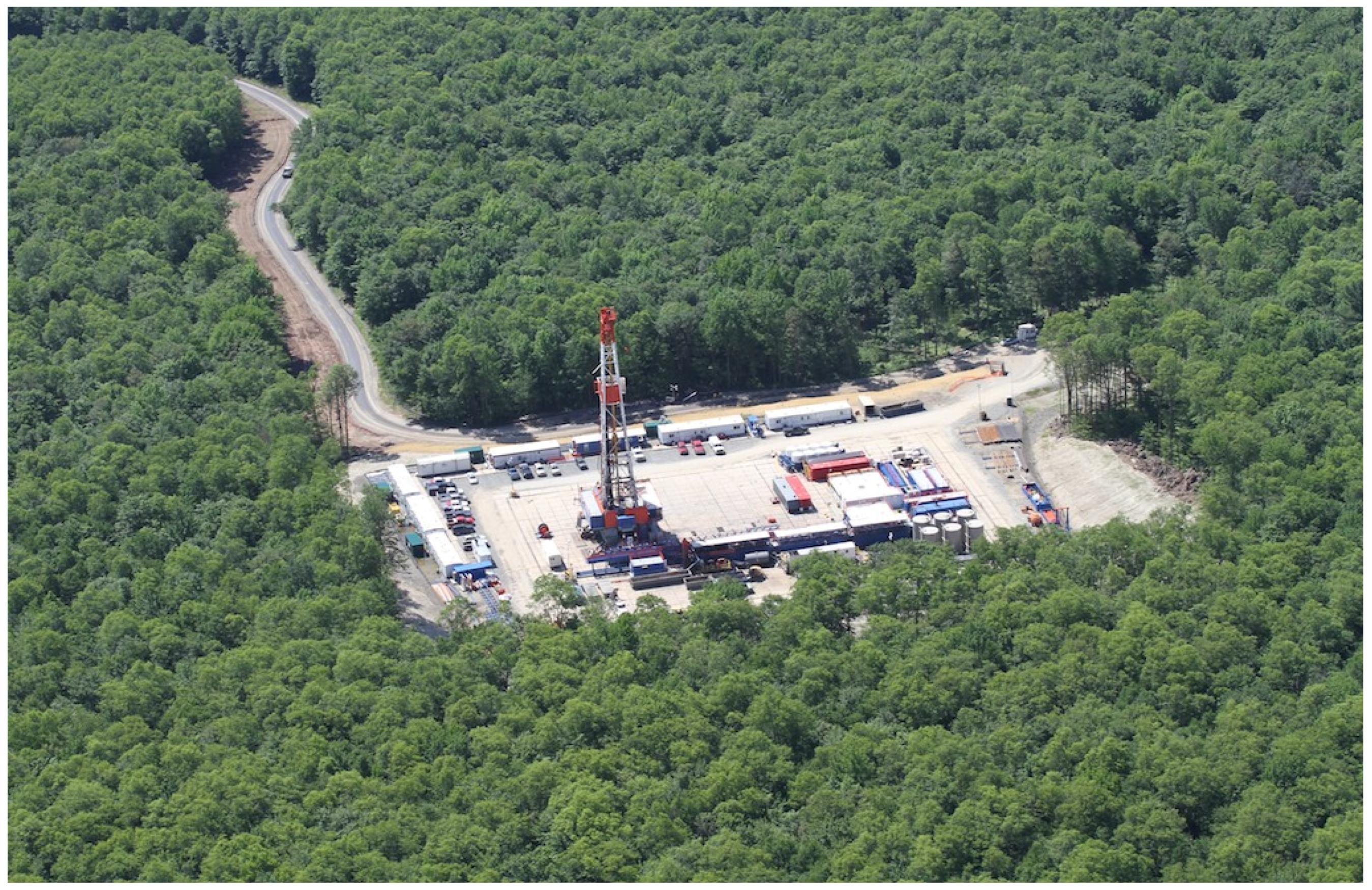
3.1. Clearing of Forest for Non-Renewable Resources

Non-renewable resources underlay many forests of North America (Figure 2) [16]. Historically, traditional surface mining was used to recover most non-renewable resources, which has conventionally been a high magnitude disturbance that can remove whole forest ecosystems and remains a primary land use for many forested regions in North America today. For example, coal is mined throughout Appalachia in the U.S.; uranium in Northern Saskatchewan, Canada; bitumen in Alberta’s oil sands; diamonds and gold in Northwest Territories, Canada; and a variety of base metals in Ontario and Québec, Canada [22]. Nearly 140 million ha of boreal forest has been developed for oil sands mining in Alberta, more than one-fifth of the province [23]. Approximately 338,000 ha of the Canadian boreal forest zone is directly disturbed by mines, oil and gas infrastructure, and well sites, exclusive of nearly 353,000 km of seismic exploration lines and pipelines that account for more than half of all linear features in the Canadian boreal [24].
Figure 2. The coincidence of North American forest cover (green) and major underlying hydrocarbon basins (transparent gray). Black boxes bound forested regions currently undergoing rapid energy development: (A) oil sands in Alberta, Canada; (B) Marcellus and Antrim shale basins in Northeastern U.S.; and (C) the Gulf of Mexico oil and gas basin in Southeastern U.S.
Land 03 00617 g002
In recent decades, several unconventional in situ technologies have been developed for recovering hydrocarbons and are being implemented around the continent. In the U.S., 90% of wells drilled on public lands, much of which is forested, use hydraulic fracturing (Figure 1) [25]. In Canada, a process known as steam-assisted gravity drainage is used to recover heavy and high-viscosity bitumen from deep oil sands deposits in Alberta. Many of these advancements in hydrocarbon recovery allow for a much larger sub-surface area to be developed, since deeper deposits can be recovered without surface mining. As a result, well sites related to hydrocarbon extraction have increased substantially on forested landscapes globally over the past two decades due to the rise in energy prices and advancements in recovery technologies.
Although well sites and mines are regularly mapped, many of their impacts are not discrete. Ecosystem services such as water purification, carbon storage, and subsistence resources can be negatively impacted by oil and gas activities (Table 1, [20,26,27,28,29,30,31,32,33,34,35]). For example, elevated levels of toxic elements by surface mining of the oil sands (Figure 2a) and coal mining seep into local watersheds [26,27,28] and hydraulic fracturing in the Marcellus and Antrim shale basins (Figure 2b) has been associated with methane contamination of drinking water [29]. Surface mining the oil sands and coal mining has been associated with massive carbon release [26,30] and well sites and seismic lines can reduce carbon storage [20,31]. Finally, forest habitat use by ungulates adjacent to industrial sites can be severely attenuated depending on the level of anthropogenic activity and changes to the distribution of these game fauna can severely impact both subsistence resources and ecosystem dynamics [32,33,34,35].
The legacies associated with non-renewable resource extraction can be significant barriers to ecosystem recovery. In North America, best practices and reclamation standards for non-renewable resource extraction are just as variable as monitoring and enforcement [36]. The small size of individual well sites gives the impression that the footprint of the oil and gas industry is relatively small (Figure 3), however, approximately 400,000 well sites have been established in Alberta alone [37]. Thus, the possibility remains that in situ recovery technologies degrade larger areas of forest than traditional surface mining. Detecting and quantifying the secondary impacts from non-renewable resource development will be critical areas of future research as these unconventional techniques become more commonplace throughout North American forests.
Figure 3. False-color (5-4-3) Landsat 5 image showing and gas well sites in Alberta, Canada.
Land 03 00617 g003

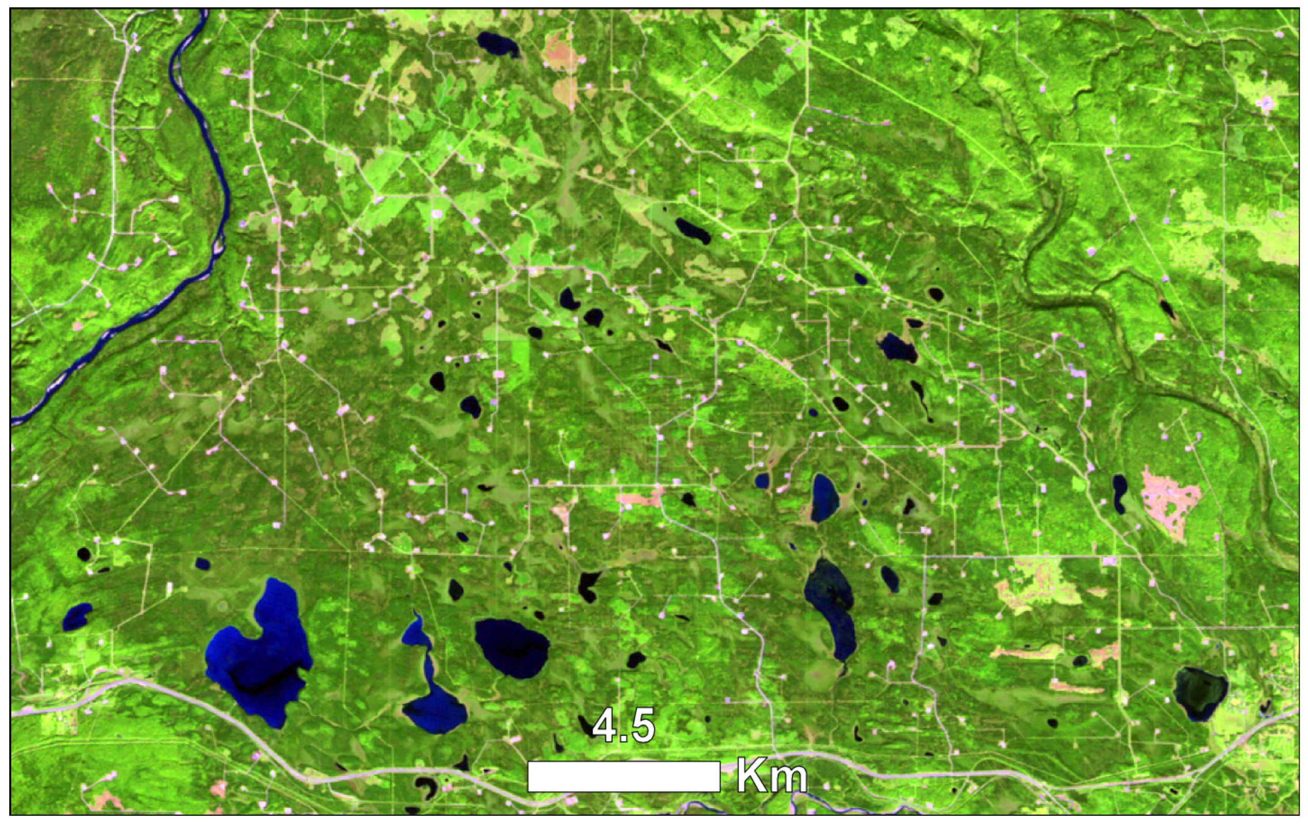
3.2. Persistent Linear Corridors

The clearing of forest for linear corridors represents one of the major challenges for conservation science in ecology. Linear corridors have at least three major impacts on forest ecosystems: access by people; travel by predators; and edge effects. Linear corridors directly remove trees and often understory vegetation to make travel easier through forested ecosystems. However, the impacts to vegetation and ecosystem dynamics often exceed the spatial boundary of the clearings.
Access into forests is one of the greatest impacts of forest land use. Most corridors are roads, but increasingly, many corridors are now related to the exploration and development of oil and gas [20,24]. In addition to the direct mining or extraction site, ancillary infrastructures often accompany non-renewable resource development that might otherwise not be present on the landscape. For example, airports may be constructed for distant locations and railways, roads and pipelines for transporting the resources to market. Ecologically, the conversion of forest to access corridors could be considered a permanent change since any known recovery interval can exceed the lifecycles of many forest-dwelling species [38].
Corridors related specifically to oil and gas infrastructure have increased significantly on the continent. An estimated US$29.1 billion will be spent annually over the next two decades on oil and gas infrastructure in both the U.S. and Canada [39]. Future pipelines are proposed to connect Northern Canada and U.S. refineries and ports in the U.S. Midwest and Gulf Coast [40]. Reflection seismology is also increasingly being used on forested landscapes more than during any prior time. Cut lines are cleared forest corridors used to explore subterraneous deposits of minerals and hydrocarbons beneath forests. Densities of cut lines on forested landscapes have reached as high as 2.7 km∙km−2 in Alberta [38]. Like well sites, many cut lines can persist on landscapes without tree cover for more than three decades and many are converted to roads and other permanent access corridors [20].
Linear corridors can modify ecosystem structure through predator-prey pathways. Travel and mobility are markedly enhanced by linear corridors resulting in increased predation rates [35] and concomitant top-down trophic cascades on community structure [41]. Additionally, habitat use can be severely attenuated due to increased predation [41,42,43,44]. Many of these effects are not discrete and it can be challenging to characterize these anthropogenic impacts using traditional landscape pattern indices and patch-based statistics [45]. For example, cut lines can have the largest footprint of any anthropogenic disturbance when a spatial buffer is applied [46].

3.3. Suppression of Historical Disturbance Regimes

Historical variability is the variation in ecological conditions at a specific scale [47,48]. Modern forest land uses suppress historical variability by abating the effects of historical disturbance regimes and homogenizing forest age classes. Throughout North America, intensive forest management zones are increasingly associated with non-renewable energy infrastructure (e.g., pipelines, mines, well sites, pumping stations). The increasing presence of energy sector infrastructure has a marked impact on forest management such as continued fire suppression and mitigation efforts. The policy toward wildfire on forested lands throughout North America has been mostly reactive management (e.g., extinguishing wildfires) rather than proactive management (e.g., prescribed fire) [49]. A consequent legacy of this land use policy is the expenditure of approximately US$3.6 billion annually over the past decade, on average, for wildfire suppression efforts in North America and these costs are expected to increase in the future [50,51,52]. In the U.S., the Smokey Bear campaign has enshrined reactive fire management as policy for over 60 years despite a general consensus among land managers that fire suppression has increased the costs and difficulty of suppressing fires [53].
Throughout the continent, the success of fire suppression efforts has been mixed. In Alberta, an initial attack (IA) strategy decreased area burned by 457,500 ha between 1983 and 1998 [54]. In British Columbia, the largest exporter of forest products in Canada, IA ensures that 92% of fires are extinguished within 24 h of detection [55] and in the U.S. the success rate is between 97% and 99% [56]. However, the success of suppressing the majority of fires is relative to wildfire size. The largest fires are the rarest, but comprise the majority of annual area burned, and area burned has actually increased over recent decades in U.S. despite rising suppression costs [56]. Bridge et al. [57] attribute discrepancies of successful fire suppression between regions to a lack of empirical evidence.
Characterizing the historical disturbance regime represents another area of controversy. Within the boreal zone, the characteristics of wildfire regimes vary spatially and temporally [58]. Without a complete understanding of the variability of the historical disturbance regime, it can be challenging to estimate exactly what is suppressed and to what degree. The lack of historical records limits any efforts of achieving such characterizations and most research has used empirical models of present-day fire behavior to estimate historical conditions [59].
Beyond the northern forests, offshore oil and gas activity in the Gulf of Mexico has contributed to wetland loss on the Mississippi River delta plain (Figure 2c). Dredging of the delta for shipping and navigation as well as undersea pipeline construction has resulted in significant loss of forested wetlands in the area due to the influx of salt water [60]. These wetlands provide a number of regulating ecosystem services, including erosion control and storm surge buffering (Table 1, [61]) that are critical to the nearby city of New Orleans Louisiana contributes approximately 12% of natural gas production in the U.S. and more than two times the total offshore production in the Gulf of Mexico [62]. Since Hurricanes Katrina and Rita in 2005, and the BP Deepwater Horizon oil spill in 2010, restoration of the wetlands has been recognized as a key priority, but the region continues to face significant challenges for implementing the restoration plans, in part due to the pre-existing oil and gas infrastructure [61,63].
Table 1. Examples of oil and gas impacts on forest ecosystem services.
Type of DisturbanceEcosystem Services ImpactExampleReferences
Surface miningCarbon storagePermanent peatland loss from oil sands mining in Alberta will release between 11.4 and 47.3 Mt∙C.
Poor productivity for abandoned mining sites leading to a conversion from a carbon sink (forest) to a source (mine).
[26,30]
Water purificationAcid mine drainage and runoff, heavy metal contamination, and high concentrations of dissolved solids associated with coal mining.
Seepage of heavy metals from more than 12,000 ha of tailing ponds associated with the oil sands mines into the Athabasca watershed, estimated at 11 million L/day.
[26,27,28]
PipelinesErosion control
Storm surge and flood buffering
Dredging of the Mississippi River delta plain for navigation and pipelines has resulted in significant loss of native marsh vegetation due to high influx of salt water, which has also increased erosion of the delta.[61]
Seismic linesCarbon storage
Subsistence resources
After 35 years, most seismic lines in Alberta had not recovered to a forested condition, thus reducing carbon storage of the forest.
Caribou (Ranger) avoid linear features, presumably due to increased risk of predation by wolves, although the association between caribou mortality and distance to linear features like seismic lines remains disputed.
[20,32,33,34]
Well sitesWater purification
Carbon storage
Subsistence resources
Methane contamination of drinking water from hydraulic fracturing in the Marcellus and Utica shale formations of Pennsylvania.
Poor productivity of abandoned well sites and the conversion of a carbon sink (forest) to a source (producing well site).
Ungulates have been observed to avoid industrial features like well sites, thus resulting in functional loss of otherwise suitable habitat.
[29,31,32,35]

3.4. Introduction of Novel Ecosystems

Forest land uses can have dramatic direct and indirect effects on community structure. Access corridors are common throughout North American forests and these features can serve as vectors for transporting invasive species throughout a landscape. Invasion of non-native species can result in changes to ecosystem composition, structure and function. Novel combinations of flora and fauna make the future state of a forested landscape challenging to predict and render comparisons to historical states unreliable. Non-native species can be introduced into forests directly by intentional planting, as in the case of Alberta where, up to ca. 1990, cut lines and well sites were re-planted with non-native plant species [29,46], or indirectly by unintentional transportation on vehicles and people [64]. Such dispersal mechanisms are exacerbated in forests undergoing significant energy development because density of access features can be as much as four times greater on these landscapes due to pipelines, cut lines, and roads connecting to well sites [65]. Moreover, forest edge habitats are particularly prone to be invaded by non-native plant species due to exposure to wind, light, and nutrient availability [46]. The ecological impacts of non-native species are numerous and Ricciardi and colleagues [66] review and compile hypotheses of the mechanisms related to each.
In North America, the distribution and abundance of predators has been altered by forest land uses related to energy development [67]. In the Rocky Mountain Foothills of Alberta, grizzly bear (Ursus arctos) populations have declined due to human-related mortality associated with the increasing density of access corridors in the region and the range of the species has been constrained by a greater presence of humans [67,68]. Wolves (Canis lupus) showed similar responses to human presence on heavily developed landscapes and, as a result, the predation success and behavior of the species was altered leading to other changes in the trophic web [41].
Since the 1960s, predators have been perceived to exert top-down controls on community structure [69]. Anthropogenic activity is believed to mediate trophic cascading by removing predators or increasing the rate of predation [41]. For example, in Yellowstone the expatriation of wolf was related to reduced cottonwood (Populus spp.) and aspen (Populus tremuloides) recruitment [70,71]. In Alberta, access corridors are thought to increase wolf predation on woodland caribou [60] and a similar observation was described for wolf distributions in Eastern Canada [42,43]. However, a more recent study cast doubt on this mechanism [72] and research involving other large predators has shown that top-down controls are not a panacea for ecosystem management [73]. Nonetheless, such changes in predator-prey relations can have negative consequences for provisioning ecosystem services and subsistence resources like the distribution of game fauna (Table 1, [32,33,34,35]).
Terrestrial arthropods are much less charismatic fauna than vertebrates, but represent the largest component of biodiversity in North American forests ecosystems and are responsible for the majority of predator-prey interactions. Due to their size and limited mobility, arthropods are particularly sensitive to changes in microclimate at local scales, which suits their application as ecological indicators [74]. Species richness has been shown to increase in edge habitats throughout North America [75,76,77] and other boreal forests [78]. Arthropod response to oil and gas activities is relatively understudied compared with forest harvesting [75,76]. However, research following the BP Deepwater Horizon oil spill in the Gulf of Mexico, during 2010, showed that terrestrial arthropods were quite sensitive to oil exposure, but retained the capacity to recover in the following season given adequate vegetation cover [79]. Arthropod response to natural gas flaring and terrestrial oil spills remains a critical area of future research given the rapid development of deep shale natural gas resources and offshore recovery technologies throughout the continent. Changes in community composition and trophic structure are very challenging to map because they are dynamic processes that are dependent on season-to-season conditions, yet these anthropogenic-mediated changes can have profound impacts on forest ecosystems.

3.5. Eradication of Ecological Memory

Many anthropogenic disturbances are high-magnitude events that remove the majority of woody biomass at the surface. Biological legacies such as seed stored in the soil profile and dead wood are termed ecological memory [80], so-called because they are the elements that allow an ecosystem to maintain its characteristic identity when disturbed. Forest land uses can severely damage the integrity of ecological memory by compacting or removing forest soils, removing the majority of woody biomass, and permanent or near-permanent conversion of forest to a non-productive state.
Surfaces such as roads and cut lines can severely modify or remove the underlying soil profile that stores the seed and bud potential of the forest [46]. If disturbance severely impacts the soil profile then colonization is likely to occur from dispersal rather than emerging from the local bud or seed bank. After 35 years, the majority of cut lines in Alberta continued to persist with a cover of low forbs and only 8% had recovered to a majority cover of woody vegetation [20]. Similarly, well site construction can severely compact soils and reclaiming these features to forest is limited by poor recruitment, growth and survival by trees [62]. An apparent barrier to successful reforestation for these disturbances in Canada is the lack of clearly written standards and procedures for forests [46].
Wildfires are known to leave patches of live island remnants and unburned residual forest within the perimeter of a burn [59]. In the absence of stand-replacing wildfire, senescence of the pioneer forest cohort leads to large abundances of downed woody debris, which provides habitat for ground- and stream-dwelling fauna and colonization sites for emergent cohorts of autotrophs [81]. Similarly, windthrow can catalyze localized patterns of forest regeneration [82]. Total dead wood can comprise up to 18% of all woody biomass in cool, moist temperate forests [83,84]. The practice of clear cutting significantly reduces dead wood compared to wildfire [85] and coarse woody debris has been removed from stream and river channels in North America for centuries to improve navigation [81]. The result of these activities has been complete anthropogenic engineering of forest and stream ecosystems and a significant loss of ecological memory related to dead wood structures.
The majority of forest land uses related to energy development permanently convert forest or remove forest cover for long periods, which can reduce the accumulation of ecological memory to forest ecosystems. For example, surface mining and activities related to non-renewable resource extraction can destroy decades-long accumulations of ecological memory stored in soils. A reclaimed coal mine grassland in Appalachia U.S. had significantly reduced levels of P compared with a reference watershed, and the macroinvertebrate community structure and in-stream leaf decomposition rates were particularly sensitive to the changes of forest cover [86]. Moreover, seeding reclaimed forest land with native species has only become accepted in the U.S. [87] and Canada [38] since the 1990s. Ecological memory can be very difficult to map aerially since the majority of these fine scale structures occur below the forest canopy and below the ground surface. A great challenge remains for mapping and studying the impacts of forest land uses on the distribution, abundance, and quality of ecological memory.

4. Detecting Anthropogenic Disturbance Regimes

Central to remote detection of disturbance is the concept that energy absorption and reflectance varies with the structural characteristics of land cover types. Remote detection of disturbance for vegetative cover such as forest relies on energy exchange properties in several key regions of the electromagnetic spectrum: (1) the absorption of visible energy; (2) the scattering of red and near-infrared energy at the “red edge”; (3) the absorption of short-wave infrared energy; and (4) the reflection of thermal energy [88,89]. Property (1) is associated with leaf pigments, properties (2) and (3) are associated with cell structure, and property (4) is associated with the fractions of soil and vegetation in a pixel [89]. Nemani and Running [89] were among the first to recognize a disturbance trajectory by relating energy exchange to land cover types.
The initial work on relating properties of energy exchange to land cover types pioneered a number of breakthroughs in disturbance detection specific to forested ecosystems. Healey and colleagues [90] developed a disturbance index (DI) based on a linear combination of Kauth and Thomas’ [91] earlier tasseled cap transformation of Landsat-derived spectral reflectance. With the free public release of Landsat imagery in 2008 [92], and significant advancements in computing capabilities, every satellite observation in the Landsat archive is now being utilized for change detection and classification of land cover [93,94]. Automated change detection has now been made possible by novel algorithms such as the object-based disturbance inventory framework [95,96,97], the vegetation change tracker (VCT) [98], and Landsat-based detection of trends in disturbance and recovery (LandTrendr) [99], which have been used to detect forest change at continental scales for the first time using Earth observations [100]. Such advancements in the discipline and computer processing have led to the first high-resolution map of recent forest cover changes for the entire planet [101] and near-real time monitoring of forest condition [102].
To date, there have been a number of studies focused on detecting, mapping, and monitoring forest change related to energy development. Fernández-Manso and colleagues [103] showed that coal mines could be extracted and mapped as features derived from endmember spectral mixture analysis using Landsat data with consistent and accurate results across three global study areas. Townsend and colleagues [104] characterized changes in the extent of surface mining and reclamation in Appalachia U.S. and observed that forest cover and active mines declined between 1976 and 2006 while reclaimed land increased over the same period. Such detection and mapping approaches can complement the disturbance inventory framework proposed by Linke and McDermid [95,96,97], and are well-suited to multiple-use landscapes undergoing rapid energy development.
Change detection at finer scales will be essential for contextualizing and attributing disturbance impacts to forest land uses. While there has been tremendous advancement in remote detection of disturbance and forest change using known spectral properties of vegetation, there has been less progress toward developing new methods for detecting novel types of change seen in the Anthropocene. Ellis and Ramankutty [14] methodically mapped the relationship between vegetation cover derived from MODIS and population density on a global scale to develop the anthromes concept. In the future, it will become necessary for research programs to detect and monitor change at finer spatial scales since the impacts of anthropogenic disturbance to forests are most commonly more localized and heterogeneous than a Landsat or MODIS pixel represents. Aerial photography is the oldest remote sensing technology that has resulted in the longest continuous record of Earth observation [105]. Recent advancements in automated classification of aerial photographs may open the possibility of interpreting the historical caches of aerial photographs and make change detection at finer scales practical for some regions [106].
Reliable detection of ecosystem structure around access corridors will permit sound characterization of ecological response to anthropogenic disturbance. Light detection and ranging (LiDAR) has emerged as a means to directly sense—rather than infer from optical wavelengths—forest structure. Discrete return LiDAR systems (small footprint LiDAR) operate at a spatial scale of approximately 0.2 to 0.9 m and full waveform systems (large footprint LiDAR) generally detect structures above 8 m [107]. Discrete return systems are useful for detecting structural information at the scale of an individual tree while full waveform systems can detect the variability of structure height at a plot scale. Airborne scanning LiDAR has been applied to measure a variety of structural attributes of forests including canopy height, mean stem diameter, stem number, and stem volume [108]. LiDAR may be particularly robust for detecting structural forest change, especially for regions that are disturbed with finer-scale access corridors such as roads, cut lines, pipe lines, and transmission lines. Full waveform systems have the potential to detect and characterize anthropogenic edge features that often dominate anthropogenic landscapes.
Detection of anthropogenic disturbance regimes will require the use of multi-scalar Earth-observations. Combinations of spectral, contextual and structural information will lead to new breakthroughs in processing, analyzing and characterizing remotely sensed data. There remain many possibilities for detecting anthropogenic disturbance regimes. For example, night-time light emittance by human settlements and other activities is a fascinating and underexplored field of investigation [109], especially for detecting the spatial influence of anthropogenic disturbance regimes (Figure 4). Night-time light emittance was recently used to estimate global natural gas flaring [110], which could be particularly relevant to some North American forests where non-renewable resource development is expanding. Ultimately, Earth-observation and characterization of anthropogenic disturbance regimes should aim to detect energy exchange via a range of spectral, spatial, and temporal domains. The importance of direct observation, such as in situ long-term monitoring should not be understated. Ground surveys and studies are essential to supplement, train, and verify remote sensing techniques. Developing research should focus on relating ground data to spectral signals that can be applied across broad scales for monitoring purposes. The future development of a framework for relating remotely-sensed indicators to ecological and social responses will be a capstone in the progress toward monitoring the Anthropocene.
Figure 4. Nighttime light intensity for North America collected in 1996 and 1997 by the Operational Linescan System of the Earth-Observing Defense Meteorological Satellite Constellation.
Land 03 00617 g004

5. Implications and Conclusions

Earth-observation and characterization of anthropogenic disturbance regimes of forests will become requisites for understanding global patterns of forest use during the Anthropocene. The substantial increase in energy development and consumption over recent decades, and in particular fossil fuels, will likely undermine ecosystem-based management of forested ecosystems. Several ecological components have already been exacerbated by energy development including biodiversity and habitat loss. The current state of knowledge of energy development in forests is primarily limited to persistent linear corridors and surface mining. As the number of in situ projects rapidly increase in forested ecosystems, research programs should focus on the non-discrete impacts of energy development. Moreover, research into the monitoring of pipeline impacts to forested ecosystems will be critical during this decade of new expansions.
To date, the majority of impacts of oil and gas activities have been characterized by research from outside the industry. The forestry industry is often a primary stakeholder in landscapes undergoing rapid energy development and is usually responsible for maintaining forest structure, function, and composition as part of sustainable forest management objectives. Thus, most monitoring research on the impacts of energy development is conducted by the forestry industry in order to meet internal and regulatory planning mandates. The development of a planning framework that brings all stakeholders together will be a necessary first step towards mitigating the negative impacts on multiple use landscapes undergoing rapid energy development.
Furthermore, future remote sensing of energy development should be focused around integrating observations from a range of spectral, spatial, and temporal domains. Relating those data to recurring ground campaigns will provide a sound basis for monitoring, assessing, and establishing reclamation standards that are suited to forested ecosystems. There remain a number of unique opportunities for exploring the impacts of energy development on forested ecosystems. For example, nighttime lights can be used as a proxy for the level of oil and gas activities based on flaring, and disturbance trend algorithms can provide new insights into the persistence and recovery success of abandoned mines, well sites, and cut lines. These and other new indicators will form the basis toward monitoring forest change in landscapes undergoing rapid energy development.

Acknowledgments

We thank the Earth Observation Group, NOAA National Geophysical Data Center for making the nighttime lights dataset freely available to the public. We also thank SkyTruth for access to aerial imagery used in the paper. We are grateful for the comments provided by three anonymous reviewers on earlier drafts of the manuscript.

Author Contributions

The authors contributed equally to the overriding concepts and referenced examples within the paper. The lead author wrote early drafts of the manuscript with contributions from the other authors through the editorial process.

Conflicts of Interest

The authors declare no conflict of interest.

References

  1. Shvidenko, A.; Barber, C.V.; Persson, R.; Gonzalez, P.; Hassan, R.; Lakyda, P.; McCallum, I.; Milsson, S.; Pulhin, J.; van Rosenburg, B.; et al. Chapter 21: Forest and woodland systems. In The Millennium Ecosystem Assessment Series, Ecosystems and Human Well-Being: Current State and Trends; Hassan, R., Scholes, R., Ash, N., Eds.; Island Press: Washington, DC, USA, 2005; Volume 1, pp. 585–621. [Google Scholar]
  2. Food and Agriculture Organization of the United Nations (FAO-UN). Global Forest Resources Assessment 2010; FAO Forestry Paper 163; FAO: Rome, Italy, 2010. Available online: http://www.fao.org/docrep/013/i1757e/i1757e.pdf‎ (accessed on 5 March 2014).
  3. Aide, T.M.; Clark, M.L.; Grau, H.R.; López-Carr, D.; Levy, M.A.; Redo, D.; Bonilla-Moheno, M.; Riner, G.; Andrade-Núñez, M.J.; Muñiz, M. Deforestation and reforestation of Latin America and the Caribbean (2001–2010). Biotropica 2013, 45, 262–271. [Google Scholar] [CrossRef]
  4. Barbier, E.B.; Burgess, J.C.; Grainger, A. The forest transition: Towards a more comprehensive theoretical framework. Land Use Policy 2010, 27, 98–107. [Google Scholar] [CrossRef]
  5. Marris, E.; Mascaro, J.; Ellis, E.C. Perspective: Is everything a novel ecosystem? If so, do we need the concept? In Novel Ecosystems: Intervening in the New Ecological World Order, 1st ed.; Hobbs, R.J., Higgs, E.S., Hall, C.M., Eds.; Wiley-Blackwell: West Sussex, UK, 2013; pp. 345–349. [Google Scholar]
  6. Harden, C.P.; Chin, A.; English, M.R.; Fu, R.; Galvin, K.A.; Gerlak, A.K.; McDowell, P.F.; McNamara, D.E.; Peterson, J.M.; Poff, N.L.; et al. Understanding human-landscape interactions in the “Anthropocene”. Environ. Manag. 2014, 53, 4–13. [Google Scholar]
  7. Ellis, E.C. Anthropogenic transformation of the terrestrial biosphere. Philos. Trans. Royal. Soc. A 2011, 369, 1010–1035. [Google Scholar] [CrossRef]
  8. Ellis, E.C.; Goldewijk, K.K.; Siebert, S.; Lightman, D.; Ramankutty, N. Anthropogenic transformation of the biomes, 1700 to 2000. Glob. Ecol. Biogeogr. 2010, 19, 589–606. [Google Scholar]
  9. Smith, B.D. The ultimate ecosystem engineers. Science 2007, 315, 1797–1798. [Google Scholar] [CrossRef]
  10. Foley, J.A.; DeFries, R.; Asner, G.P.; Barford, C.; Bonan, G.; Carpenter, S.R.; Chapin, F.S.; Coe, M.T.; Daily, G.C.; Gibbs, H.K.; et al. Global consequences of land use. Science 2005, 309, 570–574. [Google Scholar] [CrossRef]
  11. Steffen, W.; Crutzen, P.J.; McNeill, J.R. The Anthropocene: Are humans now overwhelming the great forests of Nature? Ambio 2007, 36, 614–621. [Google Scholar] [CrossRef]
  12. Crutzen, P.J.; Stoermer, E.F. The “Anthropocene”. Glob. Chang. Newsl. 2000, 41, 17–18. [Google Scholar]
  13. Ellis, E.C.; Haff, P.K. Earth science in the Anthropocene: New epoch, new paradigm, new responsibilities. Eos 2009, 90, 473–474. [Google Scholar] [CrossRef]
  14. Ellis, E.C.; Ramankutty, N. Putting people in the map: Anthropogenic biomes of the world. Front. Ecol. Environ. 2008, 6, 439–447. [Google Scholar] [CrossRef]
  15. McDaniel, C.N.; Borton, D.N. Increased human energy use causes biological diversity loss and undermines prospects for sustainability. BioScience 2002, 52, 929–936. [Google Scholar] [CrossRef]
  16. Butt, N.; Beyer, H.L.; Bennett, J.R.; Biggs, D.; Maggini, R.; Mills, M.; Renwick, A.R.; Seabrook, L.M.; Possingham, H.P. Biodiversity risks from fossil fuel extraction. Science 2013, 342, 425–426. [Google Scholar] [CrossRef]
  17. White, P.S.; Pickett, S.T.A. Natural disturbance and patch dynamics: An introduction. In The Ecology of Natural Disturbance and Patch Dynamics; Pickett, S.T.A., White, P.S., Eds.; Academic: New York, NY, USA, 1985; pp. 3–13. [Google Scholar]
  18. Heilmann, G.E., Jr.; Strittholt, J.R.; Slosser, N.C.; Dellasala, D.A. Forest fragmentation of the conterminous United States: Assessing forest intactness through road density and spatial characteristics. Bioscience 2002, 52, 411–422. [Google Scholar] [CrossRef]
  19. Oliver, C.D.; Larson, B.C. Forest Stand Dynamics; Wiley: New York, NY, USA, 1996. [Google Scholar]
  20. Lee, P.; Boutin, S. Persistence and developmental transition of wide seismic lines in the western Boreal Plains of Canada. J. Environ. Manag. 2006, 78, 240–250. [Google Scholar] [CrossRef]
  21. Odum, E.P. The strategy of ecosystem development. Science 1969, 164, 262–270. [Google Scholar]
  22. Bernstein, R.; Eros, M.; Quintana-Velázquez, M. Mineral Facilities of Latin America and Canada. United States Geological Survey; Open-File Report 2006–1375; Available online: http://pubs.usgs.gov/of/2006/1375/pdf/ofr2006-1375-table.pdf (accessed on 4 March 2014).
  23. Johnson, E.A.; Miyanishi, K. Creating new landscapes and ecosystems: The Alberta oil sands. Ann. N.Y. Acad. Sci. 2008, 1134, 120–145. [Google Scholar] [CrossRef]
  24. Pasher, J.; Seed, E.; Duffe, J. Development of boreal ecosystem anthropogenic disturbance layers for Canada based on 2008 to 2010 Landsat imagery. Can. J. Remote Sens. 2013, 39, 1–17. [Google Scholar] [CrossRef]
  25. United States Department of the Interior, Bureau of Land Management. Oil and gas; Well stimulation, including hydraulic fracturing, on federal and Indian lands. Fed. Regist. 2013, 78, 31635–31677. [Google Scholar]
  26. Rathore, C.S.; Wright, R. Monitoring environmental impacts of surface coal mining. Int. J. Remote Sens. 1993, 14, 1021–1042. [Google Scholar] [CrossRef]
  27. Timoney, K.P.; Lee, P. Does the Alberta tar sands pollute? The scientific evidence. Open Conserv. Biol. J. 2009, 3, 65–81. [Google Scholar] [CrossRef]
  28. Kelly, E.N.; Schindler, D.W.; Hodson, P.V.; Short, J.W.; Radmanovich, R.; Nielsen, C.C. Oil sands development contributes elements toxic at low concentrations to the Athabasca River and its tributaries. Proc. Nat. Acad. Sci. USA 2010, 107, 16178–16183. [Google Scholar]
  29. Osborn, S.G.; Vengosh, A.; Warner, N.R.; Jackson, R.B. Methane contamination of drinking water accompanying gas-well drilling and hydraulic fracturing. Proc. Nat. Acad. Sci. USA 2011, 108, 8172–8176. [Google Scholar] [CrossRef]
  30. Rooney, R.C.; Bayley, S.E.; Schindler, D.W. Oil sands mining and reclamation cause massive loss of peatland and stored carbon. Proc. Natl. Acad. Sci. USA 2012, 109, 4933–4937. [Google Scholar] [CrossRef]
  31. MacFarlane, A.K. Revegetation of Wellsites and Seismic Lines in the Boreal Forest. Bachelor’s Thesis, University of Alberta, Edmonton, AL, Canada, 1999. [Google Scholar]
  32. Dyer, S.T.; O’Neill, J.P.; Wasel, S.M.; Boutin, S. Avoidance of industrial development by woodland caribou. J. Wildl. Manag. 2001, 65, 531–542. [Google Scholar] [CrossRef]
  33. Latham, D.M.; Latham, M.C.; Boyce, M.S.; Boutin, S. Movement responses by wolves to industrial linear features and their effect on woodland caribou in northeastern Alberta. Ecol. Appl. 2011, 21, 2854–2865. [Google Scholar] [CrossRef]
  34. James, A.R.C.; Stuart-Smith, A.K. Distribution of caribou and wolves in relation to linear corridors. J. Wildl. Manag. 2000, 64, 154–159. [Google Scholar] [CrossRef]
  35. Sawyer, H.; Nielson, R.M.; Lindzey, F.; McDonald, L.L. Winter habitat selection of mule deer before and during development of a natural gas field. J. Wildl. Manag. 2006, 70, 396–403. [Google Scholar] [CrossRef]
  36. Smyth, C.R.; Dearden, P. Performance standards and monitoring requirements of surface mine reclamation success in mountainous jurisdictions of western North America: A review. J. Environ. Manag. 1998, 53, 209–229. [Google Scholar] [CrossRef]
  37. Alberta Environment and Sustainable Resource Development. Drilled, Abandoned and Reclaimed Well in Alberta, 1963–2012. Available online: http://esrd.alberta.ca/focus/state-of-the-environment/land/response-indicators/oil-and-gas-wells-reclamation.aspx (accessed on 10 June 2014).
  38. Timoney, K.; Lee, P. Environmental management in resource-rich Alberta, Canada: First world jurisdiction, third world analogue? J. Environ. Manag. 2001, 63, 387–405. [Google Scholar] [CrossRef]
  39. Interstate Natural Gas Association of America (INGAA). North American Midstream Infrastructure through 2035: Capitalizing on our Energy Abundance. Technical Report. 2014. Available online: http://www.ingaa.org/File.aspx?id=21498 (accessed on 27 May 2014).
  40. Parfomak, P.W.; Pirog, R.; Luther, L.; Vann, A. Keystone XL Pipeline Project: Key Issues; Congressional Research Service: Washington, D.C., USA. Available online: http://digitalcommons.ilr.cornell.edu/key_workplace/1011/ (accessed on 4 June 2014).
  41. Hebblewhite, M.; White, C.A.; Nietvelt, C.G.; McKenzie, J.A.; Hurd, T.E.; Fryxell, J.M.; Bayley, S.E.; Paquet, P.C. Human activity mediates a trophic cascade caused by wolves. Ecology 2005, 86, 2135–2144. [Google Scholar] [CrossRef]
  42. Lesmerises, F.; Dussault, C.; St-Laurent, M.-H. Wolf habitat selection is shaped by human activities in a highly managed boreal forest. For. Ecol. Manag. 2012, 276, 125–131. [Google Scholar] [CrossRef]
  43. Lesmerises, F.; Dussault, C.; St-Laurent, M.-H. Major roadwork impacts the space use behavior of gray wolf. Landsc. Urban Plan. 2013, 112, 18–25. [Google Scholar] [CrossRef]
  44. Leblond, M.; Dussault, C.; Ouellet, J.-P. Avoidance of roads by large herbivores and its relation to disturbance intensity. J. Zool. 2013, 289, 32–40. [Google Scholar] [CrossRef]
  45. Haines-Young, R.; Chopping, M. Quantifying landscape structure: A review of landscape indices and their application to forested landscapes. Prog. Phys. Geogr. 1996, 20, 418–445. [Google Scholar] [CrossRef]
  46. MacFarlane, A.K. Vegetation Response to Seismic Lines: Edge Effects and on-Line Succession. Master’s Thesis, University of Alberta, Edmonton, AL, Canada, 2003. [Google Scholar]
  47. Morgan, P.; Aplet, G.H.; Haufler, J.B.; Humphries, H.C.; Moore, M.M.; Wilson, W.D. Historical range of variability. J. Sustain. For. 1994, 2, 87–111. [Google Scholar]
  48. Landres, P.B.; Morgan, P.; Swanson, F.J. Overview of the use of natural variability concepts in managing ecological systems. Ecol. Appl. 1999, 9, 1179–1188. [Google Scholar]
  49. British Columbia Ministry of Forests, Lands and Natural Resource Operations, Wildfire Management Branch. Wildfire Management Strategy 2010. Available online: http://bcwildfire.ca/prevention/PrescribedFire/docs/BCWFMS.pdf (accessed on 5 March 2014).
  50. Gorte, R. The Rising Cost of Wildfire Protection. Headwater Economics. Available online: http://headwaterseconomics.org/wphw/wp-content/uploads/fire-costs-background-report.pdf (accessed on 5 March 2014).
  51. Taylor, S.W.; Stennes, B.; Wang, S.; Taudin-Chabot, P. Integrating Canadian wildland fire management policy and institutions: Sustaining natural resources, communities and ecosystems. In Canadian Wildland Fire Strategy: Background Syntheses, Analyses, and Perspectives; Hirsch, K.G., Fuglem, P., Eds.; Natural Resources Canada: Edmonton, AL, Canada, 2006; pp. 3–25. [Google Scholar]
  52. Gould, J.S.; Patriquin, M.N.; Wang, S.; McFarlane, B.L.; Wotton, B.M. Economic evaluation of research to improve the Canadian forest fire danger system. Forestry 2013, 86, 317–329. [Google Scholar] [CrossRef]
  53. Donovan, G.H.; Brown, T.C. Be careful what you wish for: The legacy of Smokey Bear. Front. Ecol. Environ. 2007, 5, 73–79. [Google Scholar] [CrossRef]
  54. Cumming, S.G. Effective fire suppression in boreal forests. Can. J. For. Res. 2005, 35, 772–786. [Google Scholar] [CrossRef]
  55. British Columbia Ministry of Forests, Lands and Natural Resource Operations, Wildfire Management Branch. Wildfire Management Branch Strategic Plan 2012–2017. Available online: http://bcwildfire.ca/Strategic_Planning/docs/Wildfire%20Management%20Strategic%20Plan%202012_17.pdf (accessed on 5 March 2014).
  56. Stephens, S.L.; Ruth, L.W. Federal forest-fire policy in the United States. Ecol. Appl. 2005, 15, 532–542. [Google Scholar] [CrossRef]
  57. Bridge, S.R.J.; Miyanishi, K.; Johnson, E.A. A critical evaluation of fire suppression effects in the boreal forest of Ontario. For. Sci. 2004, 51, 41–50. [Google Scholar]
  58. Andison, D.W.; McCleary, K. Detecting regional differences in with-wildfire burn patterns in western boreal Canada. For. Chron. 2014, 90, 59–69. [Google Scholar] [CrossRef]
  59. Andison, D.W. The influence of wildfire boundary delineation on our understanding of burning patterns in the Alberta foothills. Can. J. For. Res. 2012, 42, 1253–1263. [Google Scholar] [CrossRef]
  60. Foy, G. Oil and gas activity and Louisiana wetland loss. J. Environ. Manag. 1990, 31, 289–297. [Google Scholar] [CrossRef]
  61. Barbier, E.B. Coastal wetland restoration and the Deepwater Horizon oil spill. Vanderbilt Law Rev. 2011, 64, 1819–1850. [Google Scholar]
  62. U.S. Energy Information Administration. Natural Gas Annual Supply and Disposition by State. Available online: http://www.eia.gov/dnav/ng/ng_sum_snd_a_EPG0_FPD_Mmcf_a.htm (accessed on 30 May 2014).
  63. Mendelssohn, I.A.; Anderson, G.L.; Baltz, D.M.; Caffey, R.H.; Carman, K.R.; Fleeger, J.W.; Joye, S.B.; Lin, Q.; Maltby, E.; Overton, E.B.; et al. Oil impacts on coastal wetlands: Implications for the Mississippi River delta ecosystem after the Deepwater Horizon oil spill. Bioscience 2012, 62, 562–574. [Google Scholar] [CrossRef]
  64. Mack, R.N.; Simberloff, S.; Lonsdale, W.M.; Evans, H.; Clout, M.; Bazzaz, F. Biotic invasions: Causes, epidemiology, global consequences and control. Issues Ecol. 2000, 5, 1–20. [Google Scholar]
  65. Schneider, R.R.; Stelfox, J.B.; Boutin, S.; Wasel, S. Managing the cumulative impacts of land uses in the western Canadian sedimentary basin: A modeling approach. Conserv. Ecol. 2003, 7, 8. [Google Scholar]
  66. Ricciardi, A.; Hoopes, M.F.; Marchetti, M.P.; Lockwood, J.L. Progress toward understanding the ecological impacts of nonnative species. Ecol. Monogr. 2013, 83, 263–282. [Google Scholar] [CrossRef]
  67. Laliberte, A.S.; Ripple, W.J. Range contractions of North American carnivores and ungulates. BioScience 2004, 54, 123–138. [Google Scholar] [CrossRef]
  68. Laberee, K.; Nelson, T.A.; Stewart, B.P.; McKay, T.; Stenhouse, G.B. Oil and gas infrastructure and the spatial pattern of grizzly bear habitat selection in Alberta, Canada. Can. Geogr. 2014, 58, 79–94. [Google Scholar] [CrossRef]
  69. Hairston, B.G.; Smith, F.E.; Slobodkin, L.B. Community structure, population control, and competition. Am. Nat. 1960, 94, 421–425. [Google Scholar]
  70. Beschta, R.L. Reduced cottonwood recruitment following extirpation of wolves in Yellowstone’s northern range. Ecology 2005, 86, 391–403. [Google Scholar] [CrossRef]
  71. Ripple, W.J.; Larsen, E.J. Historic aspen recruitment, elk, and wolves in northern Yellowstone National Park, USA. Biol. Conserv. 2000, 95, 361–370. [Google Scholar] [CrossRef]
  72. Kauffman, M.J.; Brodie, J.F.; Jules, E.S. Are wolves saving Yellowstone’s aspen? A landscape-level test of a behaviorally mediated trophic cascade. Ecology 2010, 91, 2742–2755. [Google Scholar] [CrossRef]
  73. Marris, E. Rethinking predators: Legend of the wolf. Nature 2014, 507, 158–160. [Google Scholar] [CrossRef]
  74. Langor, D.W.; Spence, J.R. Arthropods as ecological indicators of sustainability in Canadian forests. For. Chron. 2006, 82, 344–350. [Google Scholar] [CrossRef]
  75. Buddle, C.M.; Langor, D.W.; Pohl, G.R.; Spence, J.R. Arthropod responses to harvesting and wildfire: Implications for emulation of natural disturbance in forest management. Biol. Conserv. 2006, 128, 346–357. [Google Scholar] [CrossRef]
  76. Spence, J.R.; Langor, D.W.; Niemelӓ, J.; Cárcamo, H.A.; Currie, C.R. Northern forestry and carabids: The case for concern about old-growth species. Ann. Zool. Fenn. 1996, 33, 173–184. [Google Scholar]
  77. Van Wilgenberg, S.L.; Mazerolle, D.F.; Hobson, K.A. Patterns of arthropod abundance, vegetation, and microclimate at boreal forest edge and interior in two landscapes: Implications for forest birds. Ecoscience 2001, 8, 454–461. [Google Scholar]
  78. Niemelӓ, J. Invertebrates and boreal forest management. Conserv. Biol. 1997, 11, 601–610. [Google Scholar]
  79. McCall, B.D.; Pennings, S.C. Disturbance and recovery of salt marsh arthropod communities following BP Deepwater Horizon oil spill. PLoS One 2012, 7, e32735. [Google Scholar] [CrossRef]
  80. Bengtsson, J.; Angelstam, P.; Elmqvist, T.; Emanualsson, U.; Folke, C.; Ihse, M.; Moberg, F.; Nyström, M. Reserves, resilience and dynamic landscapes. AMBIO 2003, 32, 389–396. [Google Scholar]
  81. Harmon, M.E.; Franklin, J.F.; Swanson, F.J.; Sollins, P.; Gregory, S.V.; Lattin, J.D.; Anderson, N.H.; Cline, S.P.; Aumen, N.G.; Sedell, J.R.; et al. Ecology of coarse woody debris in temperate ecosystems. Adv. Ecol. Res. 1986, 15, 133–302. [Google Scholar] [CrossRef]
  82. Mitchell, S.J. Wind as a natural disturbance agent in forests: A synthesis. Forestry 2013, 86, 147–157. [Google Scholar]
  83. Krankina, O.N.; Harmon, M.E. The impact of intensive forest management on carbon stores in forest ecosystems. World Resour. Rev. 1994, 6, 161–177. [Google Scholar]
  84. Krankina, O.N.; Harmon, M.E. Dynamics of the dead wood carbon pool in northwestern Russian boreal forests. Water, Air Soil Pollut. 1995, 86, 227–238. [Google Scholar] [CrossRef]
  85. Pedler, J.H.; Pearce, J.L.; Venier, L.A.; McKenney, D.W. Coarse woody debris in relation to disturbance and forest type in boreal Canada. Forest Ecol. Manag. 2002, 158, 189–194. [Google Scholar] [CrossRef]
  86. Simmons, J.A.; Currie, W.S.; Eshleman, K.N.; Kuers, K.; Monteleone, S.; Negley, T.L.; Pohlad, B.P.; Thomas, C.L. Forest to reclaimed mine land use change leads to altered ecosystem structure and function. Ecol. Appl. 2008, 18, 104–118. [Google Scholar] [CrossRef]
  87. Richards, R.T.; Chambers, J.C.; Ross, C. Use of native plants on federal lands: Policy and practice. J. Range Manag. 1998, 51, 625–632. [Google Scholar] [CrossRef]
  88. Rock, B.N.; Vogelmann, J.E.; Williams, D.L.; Vogelmann, A.F.; Hoshizaki, T. Remote detection of forest damage. BioScience 1986, 36, 439–445. [Google Scholar] [CrossRef]
  89. Nemani, R.; Running, S. Land cover characterization using multitemporal red, near-IR, and thermal-IR data from NOAA/AVHR. Ecol. Appl. 1997, 7, 79–90. [Google Scholar] [CrossRef]
  90. Healey, S.P.; Cohen, W.B.; Yang, Z.; Krankina, O.N. Comparison of tasseled cap-based Landsat data structures for use in forest disturbance detection. Remote Sens. Environ. 2005, 97, 301–310. [Google Scholar] [CrossRef]
  91. Kauth, R.J.; Thomas, G.S. The tasselled cap—A graphic description of the spectral-temporal development of agricultural crops as seen by Landsat. In Proceedings of the Symposium on Machine Processing of Remotely Sensed Data, West Lafayette, IN, USA, 29 June–1 July 1976.
  92. Woodcock, C.E.; Allen, R.; Anderson, M.; Belward, A.; Bindschadler, R.; Cohen, W.; Gao, F.; Goward, S.N.; Helder, D.; Helmer, E.; et al. Free access to Landsat imagery. Science 2008, 320, 1011–1012. [Google Scholar]
  93. Wulder, M.A.; White, J.C.; Goward, S.N.; Masek, J.G.; Irons, J.R.; Herold, M.; Cohen, W.B.; Loveland, T.R.; Woodcock, C.E. Landsat continuity: Issues and opportunities for land cover monitoring. Remote Sens. Environ. 2008, 112, 955–969. [Google Scholar] [CrossRef]
  94. Zhu, Z.; Woodcock, C.E. Continuous change detection and classification of land cover using all available Landsat data. Remote Sens. Environ. 2014, 144, 152–171. [Google Scholar] [CrossRef]
  95. Linke, J.; McDermid, G.J.; Laskin, D.N.; McLane, A.J.; Pape, A.; Cranston, J.; Hall-Beyer, M.; Franklin, S.E. A disturbance-inventory framework for flexible and reliable landscape monitoring. Photogramm. Eng. Remote Sens. 2009, 75, 981–995. [Google Scholar] [CrossRef]
  96. Linke, J.; McDermid, G.J. A conceptual model for multi-temporal landscape monitoring in an object-based environment. IEEE J. Sel. Top. Appl. Earth Obs. Remote Sens. 2011, 4, 265–271. [Google Scholar] [CrossRef]
  97. Linke, J.; McDermid, G.J. Monitoring landscape change in multi-use west-central Alberta, Canada using the disturbance-inventory framework. Remote Sens. Environ. 2012, 125, 112–124. [Google Scholar] [CrossRef]
  98. Huang, C.; Goward, S.N.; Masek, J.G.; Thomas, N.; Zhu, Z.; Vogelmann, J.E. An automated approach for reconstructing recent forest disturbance history using dense Landsat time series stacks. Remote Sens. Environ. 2010, 114, 183–198. [Google Scholar] [CrossRef]
  99. Kennedy, R.E.; Yang, Z.; Cohen, W.B. Detecting trends in forest disturbance and recovery using yearly Landsat time series: 1. LandTrendr—Temporal segmentation algorithms. Remote Sens. Environ. 2010, 114, 2897–2910. [Google Scholar] [CrossRef]
  100. Masek, J.G.; Goward, S.N.; Kennedy, R.E.; Cohen, W.B.; Moisen, G.G.; Schleeweis, K.; Huang, C. United States forest disturbance trends observed using Landsat time series. Ecosystems 2013, 16, 1087–1104. [Google Scholar] [CrossRef]
  101. Hansen, M.C.; Potapov, P.V.; Moore, R.; Hancher, M.; Turubanova, S.A.; Tyukavina, A.; Thau, D.; Stehman, S.V.; Goetz, S.J.; Loveland, T.R.; et al. High-resolution global maps of 21st-century forest cover change. Science 2013, 342, 850–853. [Google Scholar]
  102. United States Department of Agriculture, Forest Service. Fire Detection Maps. Available online: http://activefiremaps.fs.fed.us/activefiremaps.php (accessed on 12 March 2014).
  103. Fernández-Manso, A.; Quintano, C.; Roberts, D. Evaluation of potential of Multiple Endmember Spectral Mixture Analysis (MESMA) for surface coal mining affected area mapping in different world forest ecosystems. Remote Sens. Environ. 2012, 127, 181–193. [Google Scholar] [CrossRef]
  104. Townsend, P.A.; Helmers, D.P.; Kingdon, C.C.; McNeil, B.E.; de Beurs, K.M.; Eshleman, K.N. Changes in the extent of surface mining and reclamation in the central Appalachians detected using a 1976–2006 Landsat time series. Remote Sens. Environ. 2009, 113, 62–72. [Google Scholar] [CrossRef]
  105. Morgan, J.L.; Gergel, S.E.; Coops, N.C. Aerial photography: A rapidly evolving tool for ecological management. Bioscience 2010, 60, 47–59. [Google Scholar] [CrossRef]
  106. Morgan, J.L.; Gergel, S.E. Automated analysis of aerial photographs and potential for historic forest mapping. Can. J. For. Res. 2013, 43, 599–710. [Google Scholar] [CrossRef]
  107. Lim, K.; Treitz, P.; Wulder, M.; St-Onge, B.; Flood, M. LiDAR remote sensing of forest structure. Prog. Phys. Geogr. 2003, 27, 88–106. [Google Scholar] [CrossRef]
  108. Næsset, E. Predicting forest stand characteristics with airborne scanning laser using a practical two-stage procedure and field data. Remote Sens. Environ. 2002, 80, 88–99. [Google Scholar] [CrossRef]
  109. Small, C.; Elvidge, C.D.; Balk, D.; Montgomery, M. Spatial scaling of stable night lights. Remote Sens. Environ. 2011, 115, 269–280. [Google Scholar] [CrossRef]
  110. Elvidge, C.D.; Ziskin, D.; Baugh, K.E.; Tuttle, B.T.; Ghosh, T.; Pack, D.W.; Erwin, E.H.; Zhizhin, M. A fifteen year record of global natural gas flaring derived from satellite data. Energies 2009, 2, 595–622. [Google Scholar] [CrossRef]

