Article

Exploring Long-Term Impact of Grazing Management on Land Degradation in the Socio-Ecological System of Asteroussia Mountains, Greece

1
Laboratory of Soils and Agricultural Chemistry, Agricultural University of Athens, Iera Odos 75, Athens 11855, Greece
2
Department of Home Economics and Ecology, Harokopio University, Venizelou 70, Athens 17671, Greece
3
Consiglio per la Ricerca e la sperimentazione in Agricoltura (CRA), Via della Navicella 2-4, I-00186 Rome, Italy
*
Author to whom correspondence should be addressed.
Submission received: 17 February 2015 / Revised: 17 June 2015 / Accepted: 18 June 2015 / Published: 3 July 2015
(This article belongs to the Special Issue Ecosystem Function and Land Use Change)

Abstract

:
The socio-ecological system dominated by pastureland in the Asteroussia Mountains (Crete, Greece) was analyzed over a long time interval (1945–2010) to identify the most relevant system’s characteristics and changes. Vegetation cover and land-uses have been quantified by analyzing aerial photographs exploring the whole study period. Soil characteristics have been assessed by carrying out an extensive field survey for the last reference year (2010) and by estimating the average soil loss for the past period using the PESERA soil erosion model validated by field measurements. Based on environmental, social and economic attributes, three major periods characterizing the socio-ecological system of Asteroussia Mountains have been distinguished. During the first and second period, the land was satisfactorily managed with moderate–low soil erosion rates despite the adverse (prevailing) soil, topographic and climate conditions for vegetation growth. The third time interval featured a rapid growth in the livestock density causing increased soil erosion rates, loss in plant productivity, and a generalized over-exploitation of natural resources. As a consequence, the desertification process has significantly increased in the last period. The analysis of the long-term evolution of socio-ecological system provided evidence to understand the main drivers of land degradation and to recommend mitigation policies specifically addressing Mediterranean pastureland.

1. Introduction

Grazing by domestic livestock affects vegetation, soil and hydrology [1]. Grazing intensity may alter the floristic composition of herbaceous species. Herbaceous species richness and abundance of each species are decreased in heavy-grazed areas [2]. Grazing animals and agricultural machinery impact soils in a similar way determining structural deformation of the soil, particularly wet soils, and soil compaction [3,4], which can reduce soil porosity and increase soil bulk density [5,6]. In turn, soil compaction decreases infiltration capacity [4,7] and promotes surface runoff generation [8]. Soil compaction, combined with the reduction of vegetation cover due to overgrazing, causes accelerated soil erosion [9,10,11,12] and reduces significantly soil water storage capacity with the consequent depletion of water resources. Vegetation cover is a key factor controlling the rate of soil loss through surface-water erosion [13,14].
Livestock density has increased during the last decades in southern Europe [15]. In many areas, especially in inland, low-accessibility mountainous districts, grazing has greatly increased with Common Agricultural Policy (CAP) subsidies. The low plant cover found in many grazing lands is regarded as a consequence of overgrazing coupled with unfavorable biophysical conditions, such as recurrent droughts [1,16]. Degradation of permanent semi-natural vegetation and the resulting soil degradation due to erosion constitute a major cause of desertification in the Mediterranean basin. Overgrazing is one of the most important land management problem as it is associated to marginal, depopulated, and low-income rural areas, whose landscape is dominated by pastures [17]. Papanastasis [15] reported that overgrazing is probably the most crucial factor of land degradation in several Greek regions. Grazing land in Greece covers more than 40% of the total surface of the country [18,19]. As in other parts of Greece, grazing constitutes an ancient tradition in Crete as it is being practiced for more than 10 thousand years since the Neolithic times [20]. The ability of the grazing animals to utilize the poor natural vegetation has led to generation of low-requirements animal breeds [21]. According to the Greek Statistical Service, the number of grazing animals (sheep and goats) in the island of Crete has been increased from 0.78 to 1.01 million in the period 1960–1980 to 1.56–2.51 million in the period 1980–2010. The present stocking rate is much higher than the pasture carrying capacity (about 0.65 million) leading to overgrazing [22]. Papanastasis et al. [23] have concluded that by moderating grazing pressure rather than completely banning livestock grazing can contribute to restoration of degraded rangelands.
Land degradation and desertification are processes that are active in arid, semi-arid and dry sub-humid areas [24]. These processes have been enhanced in the last decades by various factors including climatic variations and human activities. A comprehensive study carried out in grazing land by the EU-funded research project DESIRE (Desertification Mitigation and Remediation of Land—a global approach for local solutions) in eastern and western Europe, Latin America, Africa and Asia have identified soil erosion, forest fires, and overgrazing among the most important process or causes of land degradation and desertification. Extensive forest fires occurring in dry areas, induced by man for increasing palatable biomass production for grazing, are causes promoting soil erosion and desertification [15].
Methodologies allowing the identification of sensitive areas to desertification have already been applied in a number of studies [25,26,27]. Among them, the ESA (Environmental Sensitive Area) methodology, developed in the context of the EU-funded research project MEDALUS (Mediterranean Desertification and Land Use), appears to be the most widely applied in southern Europe and elsewhere [28,29,30] due to model simplicity and flexibility in the use of available/relevant indicators [31,32]. The procedure is based on the assessment of physical characteristics of the land such as soils, climate and vegetation. Management characteristics such as land use type, intensity in the use of land and policies are included in order to stress the importance of human-induced desertification [31]. The ESA methodology has been validated at both local and regional scales in several testing areas of southern Europe (Portugal, Spain, Italy, and Greece) under different environmental conditions [32,33,34].
Poor rangeland management practice can accelerate soil erosion and land degradation. Based on these premises, the aim of the present study is to analyze the impact of different land use and management systems on soil erosion and land degradation occurring in the last six decades (1945–2010) on a representative Mediterranean grazing land (Asteroussia Mountains in Crete, Greece). A complementary aim of this paper is to ground the evolution of the local socio-ecological pastoral system in the wider economic and technological context that may affect (land) management decisions generating pressures on the environment [35].

2. Materials and Methods

2.1. Study Area

The Asteroussia Mountains region constitutes a typical example of an overgrazed land in southern Europe. The region is located in the southern part of Crete Island, Greece, bordered to the north by the Messara valley and to the south by the Libyan Sea, covering a surface area of 384.3 km2. The region is mostly used as pasture dominated by shrubby vegetation with scattered and small cropland patches. The highly degraded grazing land in Asteroussia is characterized by steep slopes, relatively shallow soils, and adverse climatic conditions. Asteroussia is one of the most important grazing areas of Crete and it has been subjected to overgrazing for a long period, especially following the accession of Greece (1981) to the European Union.
Low-elevation areas receive an annual rainfall ranging between 500 and 750 mm, while the upper mountainous area (highest elevation: 1231 m at the sea level) receives up to 1250 mm of rain. The majority of the area is characterized by an average air temperature ranging between 15 °C and 18 °C. The geological substrates consist mainly of flysch and limestone; areas with limestone are usually characterized by the highest degree of land degradation. Areas covered with flysch soil parent material favor high surface water runoff under low vegetation cover due to low water infiltration capacity. These soils are characterized by a surface A-horizon, usually 12–18 cm thick, and an underlying cambic B-horizon. Leptosols or Cambisols are the dominant soil units in the area. Soils are mainly moderately fine-textured. The 15–30 cm soil depth class is dominant throughout the area. Relatively deep soils (class 30–60 cm) have been mapped in patches. Some of these areas are used as cropland and grazing land. Slope gradient ranges between 2% and 60%. The slope class 35%–60% is the dominant class covering the 49% of the total land. The most important land cover types are schlerophyllous vegetation, transitional woodland-shrubs and sparsely vegetated areas covering the 88% of the total investigated area. The rest of the area is covered by agricultural crops, mainly olive trees and cereals. The dominant woody plant species in the area include Olea sylvestris, Olea Europa, Salix alba (along watercourses), Pyrus amygdaliformis, Prunus webbii, Thymus capitatus, Salvia triloba, Flomis lanata, Flomis fruticosa, Sarcopoterium spinosum, Calicotome vilosa, Scilla maritime, Asfodelus aestivus, and Euphorbia characias. Overgrazing coupled with frequent fires shaped the vegetation pattern in the area determining the predominance of the less palatable fire-tolerant plant species [20].

2.2. Soil and Land Use Mapping

A soil survey was carried out in 2010 taking into account the following soil characteristics: soil texture of the surface horizon, percentage of rock fragment cover on the soil surface, depth to bedrock, topography and parent material. All these variables were recorded in a network of 113 soil mapping units. The boundaries of the mapping units were drawn on ortho-photomaps (scaled 1:30,000) provided by the Greek Ministry of Rural Development and Foods. Each mapping unit included a piece of land with similar soil and topographic characteristics such as soil texture, soil depth, slope gradient and slope configuration. Soil textural classes were defined according to the USDA system [36] and were grouped into the following textural classes: very coarse (S, LS), coarse (SL), medium (L, SiL, Si), moderately fine (SCL, CL, SiCL) and fine (SC, C, SiC).
The parent material was described based on the geological map of the area (scaled 1:30,000) provided by the Greek Institute of Geology and Mineral Exploitation (IGME). Soil depth to unconsolidated bedrock was measured in auger holes or in road cuts. The following classes of soil depth were used: very shallow (depth 0–15 cm), shallow (15–30 cm), moderately shallow (30–60 cm), moderately deep (60–100), and deep (>100 cm). A topographic map was used to classify slope gradient in eight categories: nearly level (slope 0%–2%), gently sloping (slope 2%–6%), moderately sloping (slope 6%–12%), strongly sloping (slope 12–18), moderately steep (slope 18%–25%), steep (slope 25%–35%), very steep (slope 35%–60%), and abrupt (slope > 60%).
Vegetation and land-use maps have been derived by air-photo interpretation and field observations (last period) on aerial photographs obtained in 1947 (and representing the land cover observed in the time interval before 1950), in 1971 (referring to the time interval encompassing the early 1950s and the mid-1980s), and 1995 (for the time interval between the mid-1980s and 2010s). The aerial photographs were geo-referenced and converted to standard scale using the Arc-GIS9.3 geo-referencing tool [37]. The land cover types observed in the area have been classified according to the CORINE Land Cover nomenclature [38]. Vegetation was defined on the basis of the dominant species such as shrubs, olives, bare land, among others. Plant cover was classified in five categories as follows: <25%, 25%–50%, 50%–75%, 75%–90% and >90%.

2.3. Assessing Soil Erosion and Land Desertification

Surface rainwater runoff and regulation of hydrological processes have been assessed in the area by estimating the surface water runoff using the PESERA model [14,39,40]. Areas characterized with an adequate regulation of hydrological processes are those where the highest amount of rainfall infiltrates into the soil allowing for limited or no runoff water generation. The PESERA model estimates the amount of surface water runoff taking into consideration the existing soil, vegetation, topographic and climatic conditions. In addition, the model assesses the amount of water runoff after running the water balance. An area that has the ability to retain the majority of the received rainfall is considered to have a high ability for regulating hydrological processes [41]. A classification scheme based on four regulation classes (very high: >95% of rain water infiltrated into the soil, high: 86%–95%, moderate: 70%–85% and low: <70%) was considered here. The PESERA model has been calibrated and validated under various land characteristics in Greece [42].
Soil erosion rates were assessed using the Pan-European Soil Erosion Risk Assessment (PESERA) model [14,39,40]. The model was applied on a grid base of 100 × 100 m covering the whole Asteroussia region. For the application of the soil erosion model, meteorological data, provided by the Hellenic National Meteorological Service, were used from the nearby station of Gortina. Potential evapotranpiration rate (ETo) was calculated from daily values of maximum and minimum air temperature, sunshine duration, air humidity and wind speed, using the Penman–Monteith modified equation [43]. Daily rainfall data were used and the ratio of the mean daily rainfall over the rain days was calculated for each month. Also, the ratio of the standard deviation of daily rainfall over the mean daily value was calculated for each month. The soil erosion rate was assessed for each land mapping unit and study period by running the soil erosion model for three representative years (concerning amount of rainfall) and averaging annual erosion rates. Soil depth to the bedrock for each mapping unit has been measured by carrying out soil survey in the year 2010. Changes in soil depth due to soil erosion for the previous periods were assessed by estimating the average soil loss in each study period and increasing accordingly the corresponding soil depth.
Field measurements of soil loss have been carried out in various sites of the investigated area. The area is widely covered by the non-palatable shrub Sarcopoterium spinosum, growing in close contact with the ground and thus protecting the soil from erosion. In addition, the area under the shrub receives some sediments from the shrub inter-space, either splashed during the rain period [44] or detached and transported by wind during the dry period. On the contrary, the soil surface between adjacent shrubs, which is usually covered by annual grass, is subjected to water erosion. Under these conditions, patches of non-eroded and eroded soil are observed, resulting in differences in soil thickness between the soil under the shrub and in the adjacent uncovered soil surface. Measurement of such differences in height between the non-eroded surface under the shrub and the adjacent bare soil surface has been carried out under various slope and soil characteristics in the area. Furthermore, measurements of soil depth and plant cover with perennial shrubby vegetation have been also conducted.
The Environmentally Sensitive Areas (ESAs) to desertification were identified for each study period using the methodology developed in the EU-funded research project MEDALUS III (Mediterranean Desertification and Land Use; [31]). Eight classes of land sensitivity to desertification were defined according to Kosmas et al. [31,45]: “non-affected” (N), “potentially affected” (P), three “fragile” categories (F1,F2,F3) and three “critical” categories (C1,C2,C3).

3. Results

3.1. The Evolution of the Asteroussia Pastoral System

Three major phases characterizing the recent dynamics of the socio-ecological system of Asteroussia Mountains have been distinguished: (i) the period before the early 1950s; (ii) the traditional-husbandry state period (early 1950s–mid-1980s); and (iii) the subsidized husbandry state period (mid-1980s–2010). The first period is briefly described here as it serves as the benchmark against which the effects of the studied processes in the following decades were assessed. The early 1950s mark the end of the Greek civil war that succeeded World War II and can be considered the starting point of the post-war socioeconomic recovery of Greece.
At the beginning of the “traditional-husbandry state” period, the dominant picture in Asteroussia Mountains was that of a livestock-specialized area with a rather low plant primary productivity compared to the already low average productivity of Mediterranean rangeland. Livestock production was based on controlled summer grazing in the mountains and overwintering in lowland areas, mostly in the neighboring plain of Messara, which was dominated by cereals at that time. Although formal education level was very low, there was a substantial body of local environmental knowledge available. Strong local and regional identities were formed over the years based on descent and place. A very important cultural feature was the size of the flock as a status symbol of the family [46]. Socioeconomic interactions with other areas were restricted to the local or regional level either in the form of transhumance practices or trading the products.
Gradually, after the early 1960s, the area increasingly felt the impact of intensification and specialization processes that took place in Greek agriculture. The excessive under-occupied labor force residing at that time in rural areas, due to lack of other options, was channeled to migrating abroad or to urban centers, where changes in the productive base towards industrialization were taking place. In addition, intensive growth of tourism installations, especially after the early 1970s and mainly along the northern coastal line of Crete, offered the opportunity for new jobs. A decline in population took place at higher rates in the study area compared to Crete as a whole, due to domestic and foreign out migration. In addition, ageing of the remaining population was a major land management problem [46].
At the same time, credit became available from banks stimulating the investments necessary for agricultural intensification. State research institutes developed new and more productive crop varieties that lead to increasing harvests. Intensification in the case of livestock husbandry was expressed as a continuous rise in flock size. In areas where the limited natural capital was already fully utilized, such as Asteroussia Mountains, further growth of production through increasing flocks was only possible by importing fodder from elsewhere. In turn, this was made possible at that time through a combination of processes. Increased crop production made animal fodder affordable and growing truck availability and spreading road networks made transportation possible. In a parallel development, increasing intensification of agriculture in the nearby Messara plain and the replacement of cereals by olive orchards limited the opportunities for continuing the tradition of transhumance by the end of this period. As a result, flocks started overwintering on the mountains to an ever growing degree. At the same time, low productivity cereal fields that were not worth for growing cereals for human consumption anymore were cultivated for animal forage only.
The economy of the area remained livestock-dominated throughout the mid-1980s–2010s (the subsidized husbandry state) period. Population decline continued along with population ageing, suggesting that outmigration of young people remained high. This is reflected in the education level of the resident population, which rose only moderately compared to the rise in education infrastructure. Tourism growth continued with higher rates than during the previous period leading to a decline of the share of agriculture in the regional product. New job opportunities have been created by the expansion of the public sector. Roads and other infrastructures were improved in the broad area. The presence of foreign migrants offering cheap labor from the early 1990s onwards contributed to keep many farms active.
The accession of Greece to the European Union had a great influence on the local economy especially owing to the CAP subsidies allocated to farmers. The introduction of per-head subsidies in the mid-1980s resulted in a quick shift to the new period without any major transition phase. The reasons explaining the rapidity of the response were:
  • All livestock farms were run by full-time professional stock-breeders, which resided on-site due to the nature of the operation; despite the general ageing of the population these were, and still are, mostly young that responded quickly to the new set of conditions.
  • Sheep and goat numbers per farm can be raised very quickly (i.e., within a year) without major investments, simply by slaughtering less female lambs in a particular year or series of years.
The availability of financial resources enhanced the purchase of fodder to increase flock size and the increased flock size resulted (at that time) in a higher availability of financial resources in the form of subsidies. On the other hand, the cultural impetus for increasing flocks to defend or enhance the status of the family resulted to further enhancement of flock growth [46]. This, in turn, increased the dependence on imported fodder. The simultaneous replacement of cereals in the neighboring Messara Valley, mostly by olive tree cultivation, caused a complete breakdown of transhumance to the Valley, further increasing the dependency on imported fodder. In summary, the available land resources were negatively impacted by the excessive animal load and the gradual change from controlled to free grazing without shepherd control. This period ended with the financial crisis, which is still ongoing at the time of writing and is not treated in this study.

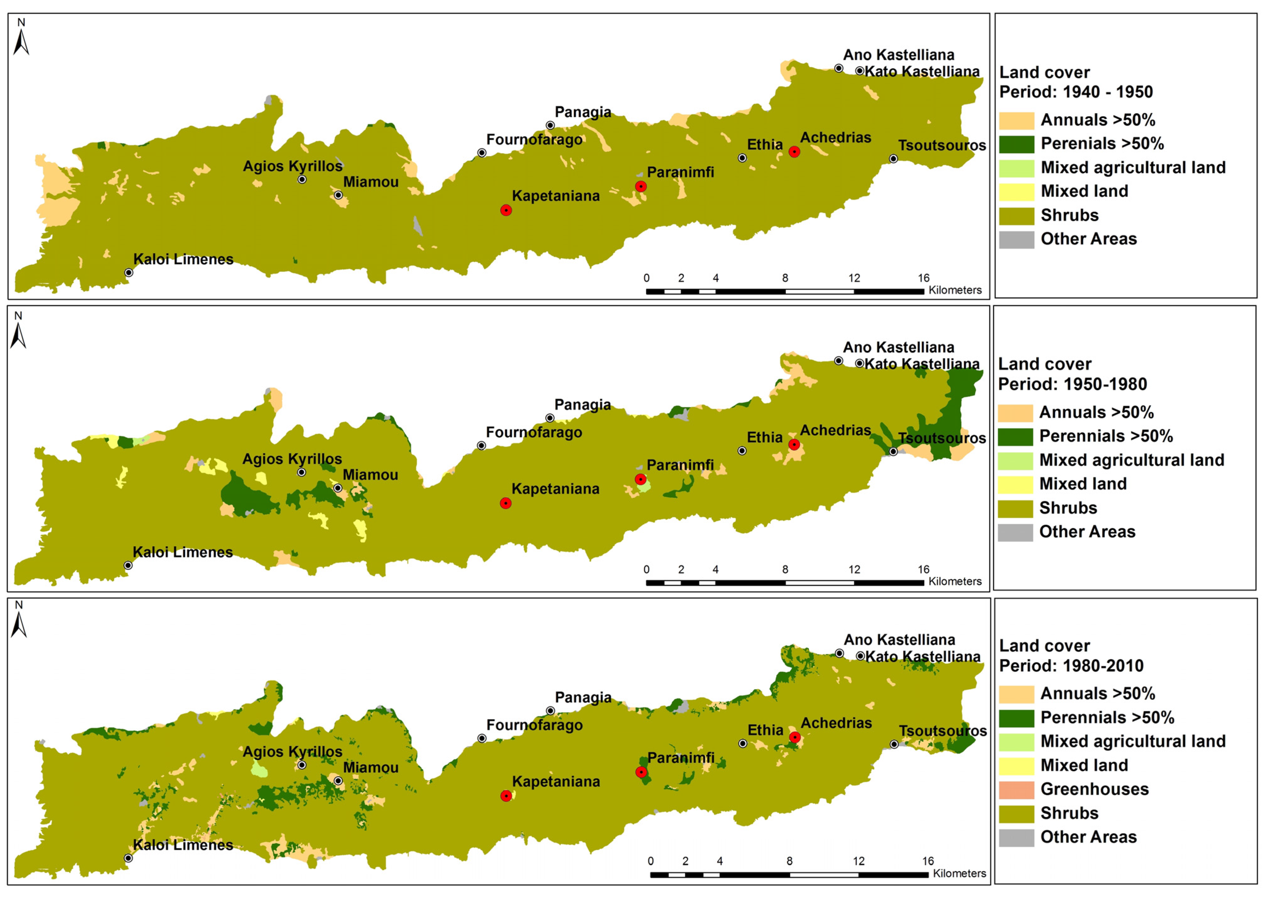
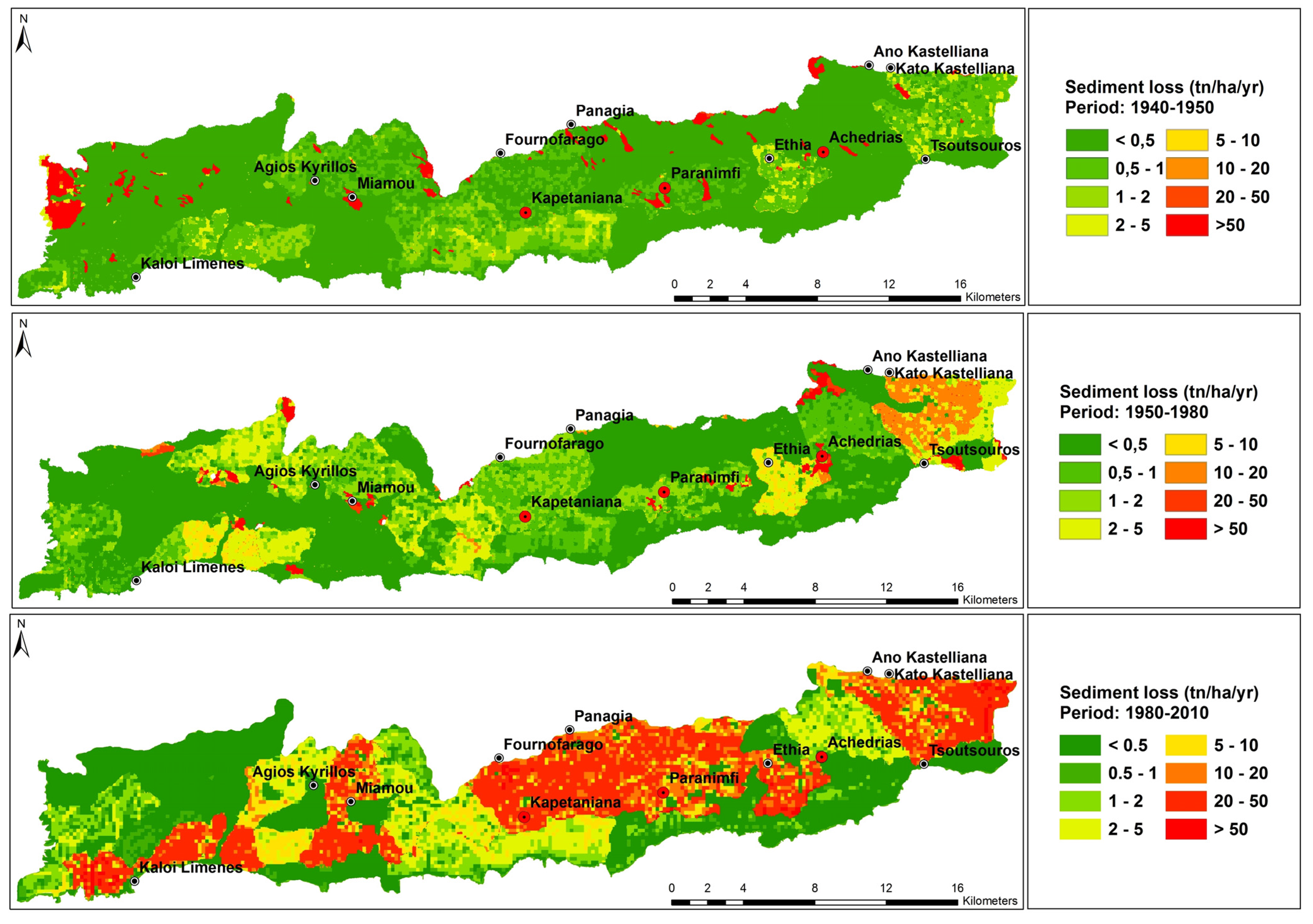
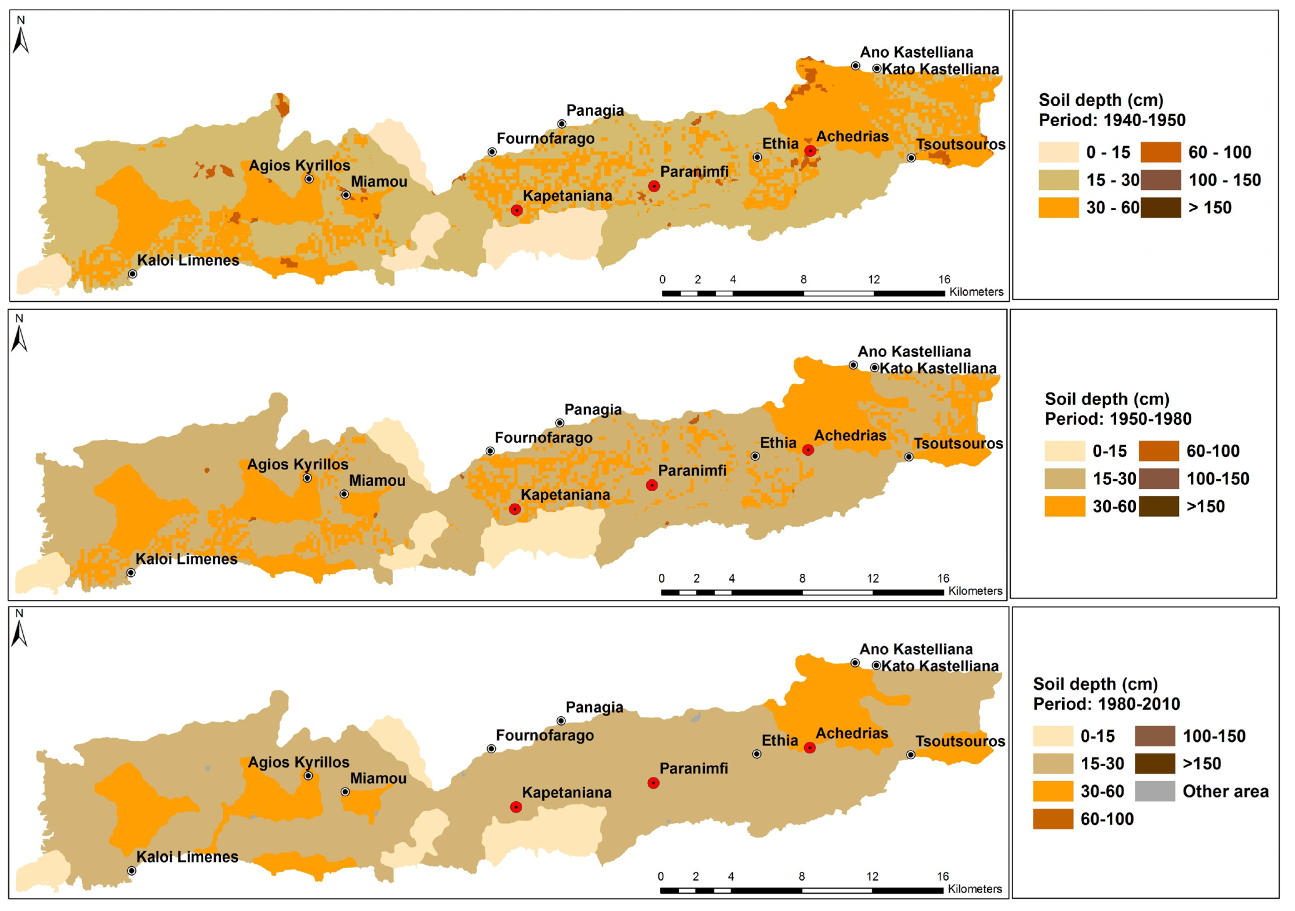
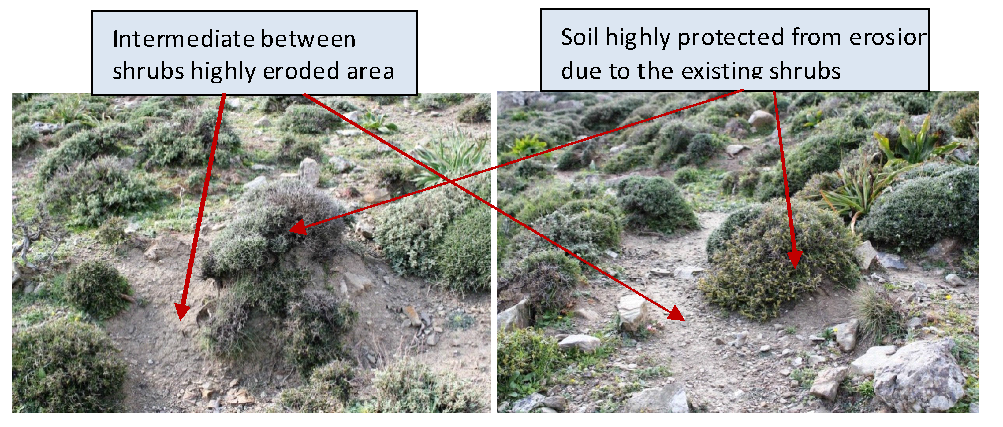
3.2. Vegetation Cover Classes Changes and Soil Erosion

During the last six decades vegetation and the use of land changed moderately in the study area. Before 1950 the majority of the land (95.5%) was covered by shrubby vegetation used as pastures (“323” CORINE Land Cover (CLC) class) (Figure 1). The remaining land (4.1% of the investigated area) was covered by non-irrigated arable crops (mainly cereals, corresponding to the “211” CLC class). During the following “traditional-husbandry state” period (1950–mid-1980s), shrubby vegetation decreased to 90.2% due to its replacement by olive groves (“223” CLC class) in an area covering 5.9% of the total investigated region, while cereals cultivation decreased slightly to 3.1% of the total area (Table 1). Shrubby vegetation decreased to 86.6% in the last “subsidized husbandry state” period (mid-1980s–2010), while olive plantations increased to 6.5%. Land cover change analysis showed a human-induced trend of replacing shrubby vegetation with perennial crops in areas with relatively deep soils. At the same time, shrubby vegetation disappeared in areas with shallow soils possibly due to soil erosion.
Figure 1. Land cover distribution in Asteroussia Mountains by time period (before 1950: upper, 1950–mid-1980s: middle, and mid-1980s–2010: lower).
Land 04 00541 g001
Table 1. Land cover of Asteroussia Mountains during the three time intervals.
Land Cover TypeVegetation CharacteristicsBefore 19501950–Mid-1980Mid-1980–2010
Area (ha)Area (%)Area (ha)Area (%)Area (ha)Area (%)
211Non-irrigated arable land1592.94.11184.03.10.00.0
221Vineyards0.00.053.20.10.00.0
223Olive groves53.20.12281.65.92515.36.5
323Sclerophyllous, maquis and garrigue36,683.495.534,672.990.233,279.386.6
241Annual and perennial crops0.00.077.70.20.00.0
242Complex cultivation patterns0.00.00.00.01417.93.7
243Agriculture and natural areas0.00.00.00.01149.93.0
Other area 99.20.3159.30.466.40.2
TOTAL 38,428.8100.038,428.8100.038,428.8100.0
Soil erosion was an important issue of land degradation in the Asteroussia Mountains during the three study periods (Figure 2). During the first time interval examined (the years immediately before 1950), the majority of the area was characterized by low rates of soil erosion. The dominant classes of soil erosion were < 0.5 t·ha−1·yr−1 and 0.5–1 t·ha−1·yr−1, covering 68.4% and 19.2% of the total area, respectively (Table 2). Higher erosion rates corresponding to the classes 1–2 t·ha−1·yr−1 and 2–5 t·ha−1·yr−1 were estimated in areas covering 5.7% and 2.8% of the total area, respectively. Soil erosion rates increased in the following “traditional-husbandry state” period (1950–mid-1980s) due to the decreased vegetation cover caused mainly by the higher number of animals grazing the area. Compared to the previous period, erosion rates in the classes <0.5 t·ha−1·yr−1 and 0.5–1 t·ha−1·yr−1 decreased to 53.0% and 14.6% of the total area, while classes 1–2 t·ha−1·yr−1 and 2–5 t·ha−1·yr−1 increased, respectively, to 12.7% and 11.0%. However, higher erosion rates (>5 t·ha−1·yr−1) have been estimated only in some restricted areas.
Figure 2. Distribution of sediment loss classes estimated for the study periods (before 1950: upper, 1950–mid-1980s: middle, and mid-1980s–2010: lower).
Land 04 00541 g002
Soil erosion rates have significantly increased in the “subsidized husbandry state” period (mid-1980s–2010) due to the increased livestock pressure resulting in overgrazing and reduction of vegetation cover. The average stocking rate has increased from 0.5–0.9 animals·ha−1 in the first and second period to 2.0–2.3 animals·ha−1 in the third period. Areas with low rates of soil erosion (lower than 0.5 t·ha−1·yr−1) cover 33.5% of the total land (Table 2). Soil erosion rates ranged from 0.004 to 0.04 t·ha−1·yr−1, which is consistent with the measurements conducted in a similar nearby grazing land with 23% slope gradient for a period of three years [47]. The next soil erosion class was 20–50 t·ha−1·yr−1, covering 23.9% of the total area. Also, high erosion rates, namely the classes 5–10 t·ha−1·yr−1, and 10–20 t·ha−1·yr−1, occurred, respectively, in 7.4% and 8.4% of the total area.
Table 2. Changes in sediment losses estimated for the three time intervals.
Sediment Loss (t·ha−1·yr−1)Before 19501950–mid-1980Mid-1980–2010
Area (ha)Area (%)Area (ha)Area (%)Area (ha)Area (%)
0–0.526311.968.420383.353.012870.933.5
0.5–17362.119.25629.114.61929.25.0
1–22198.95.74861.512.73382.48.8
2–51075.72.84211.611.04694.012.2
5–1078.80.21007.82.62830.77.4
10–204.10.01514.33.93228.48.4
20–5045.40.1230.10.69167.123.9
>501351.83.5591.11.5326.00.8
TOTAL38428.8100.038428.8100.038428.8100.0
Differences in soil erosion rates during the three study periods can be attributed both to different climatic conditions and to vegetation cover changes. The annual rainfall in the study area has decreased by 22% in the period after 1980 with a negative impact on vegetation growth. The analysis of vegetation cover during the three study intervals showed that values less than 75% have been identified in 2.2%, 4.3% and 9.2% of the study area corresponding to periods before 1950, 1950–mid-1980s, and mid-1980s–2010, respectively. The rest of the area had a vegetation cover greater than 75% in all study periods. The decrease in vegetation cover can be attributed to change in rainfall regime and to overgrazing, especially in the “subsidized husbandry state” period.
Soil erosion was a major issue of soil degradation and especially of soil thickness (Figure 3). The dominant classes of soil depth before 1950 were 15–30 cm and 30–60 cm, covering 56.8% and 33.2% of the total area, respectively (Table 3). Reflecting the increased soil erosion, the percentage of the 15–30 cm soil depth class has increased from 56.8% to 61.6% and 74.2% in 1950–mid-1980s and mid-1980s–2010 time intervals, respectively. At the same time, soil depth class 30–60 cm decreased from 33.2% in the period before 1950 to 29.9% and 17.3% in the 1950–mid-1980s and mid-1980s–2010 periods, respectively. Changes in soil depth were especially remarkable in the last period. An increase of 4.8% of the surface area falling in the soil depth class 15–30 cm in a period of 35 years (1950–mid-1980s) was estimated, with an increase of 12.6% estimated in the last decades (mid-1980s–2010). This was attributed to land overgrazing driven by marked increases of stocking rates stimulated by Common Agricultural Policy subsidies in the most recent decades.
Changes in soil depth have been verified with the use of field observations in selected sites. The study area was covered mainly by shrubs growing in contact with the ground and thus effectively protecting the soil underneath. On the contrary, the intermediate soil surface between shrubs was subjected to animal trampling compaction and raindrop impact generating water surface runoff and sediment loss (Figure 4). The comparison of the soil surface under the shrub and the adjacent bare soil surface provides an estimate of soil loss due to erosion in the previous period. Measurements conducted in the area have shown the soil loss ranged from 3.7 to 24.2 cm, depending on the slope gradient. Such soil losses can be attributed to periods even longer than a study period of 65 years. However, as the soil erosion model predicts, higher erosion rates mostly occurred in the last three to four decades, after increasing the number of grazing animals.
Figure 3. Distribution of soil depth classes in the various study periods in Asteroussia Mountains (before 1950: upper, 1950–mid-1980s: middle, and mid-1980s–2010: lower).
Land 04 00541 g003
Table 3. Changes in soil depth classes estimated for the three study periods.
Soil Depth Class (cm)Before 19501950–mid-1980Mid 1980–2010
Area (ha)Area (%)Area (ha)Area (%)Area (ha)Area (%)
0–153199.88.33200.58.33208.88.3
15–3021829.956.823669.361.628504.774.2
30–6012764.933.211490.529.96649.017.3
60–100623.41.659.50.266.40.2
100–15010.80.18.90.10.00.0
>1500.00.00.00.00.00.0
TOTAL38428.8100.038428.8100.038428.8100.0
The soil losses estimated by the erosion model (expressed as soil thickness) range from 0.1 to 12.5 cm. The soil losses estimated by the soil erosion model are about one half of the losses estimated by measuring the differences in soil depth between the soil under the shrub and in the shrub interface. The higher values estimated by the last method can be attributed to the expected increase in soil thickness under the shrub due to sediments trapped by the shrub, either splashed during the rain period [44] or detached and transported by wind during the dry period from the shrub interface.
Figure 4. Changes in soil depth due to soil erosion affected by the presence of shrubs partially covering the soil due to overgrazing occurred in the area during the last decades.
Land 04 00541 g004

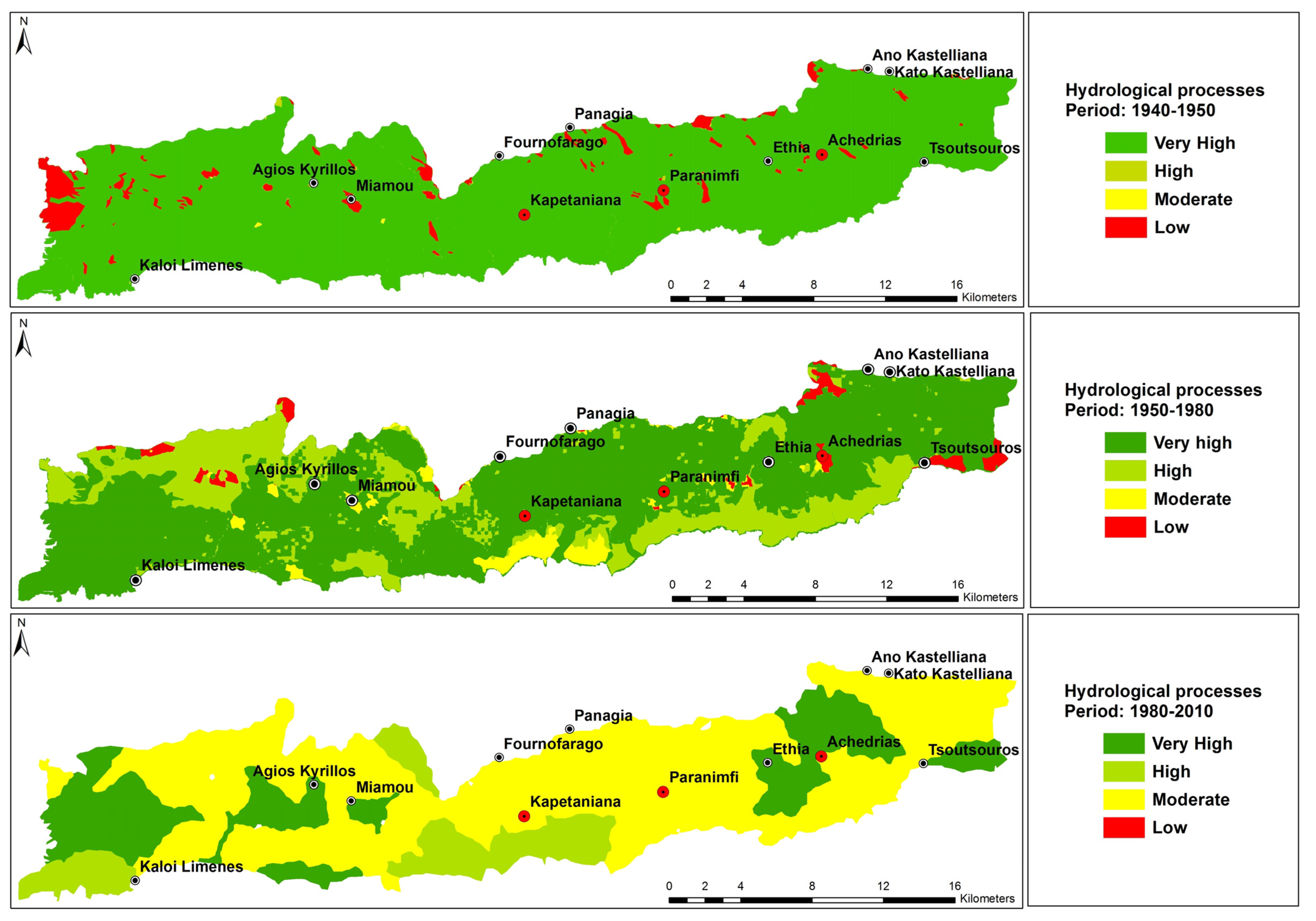
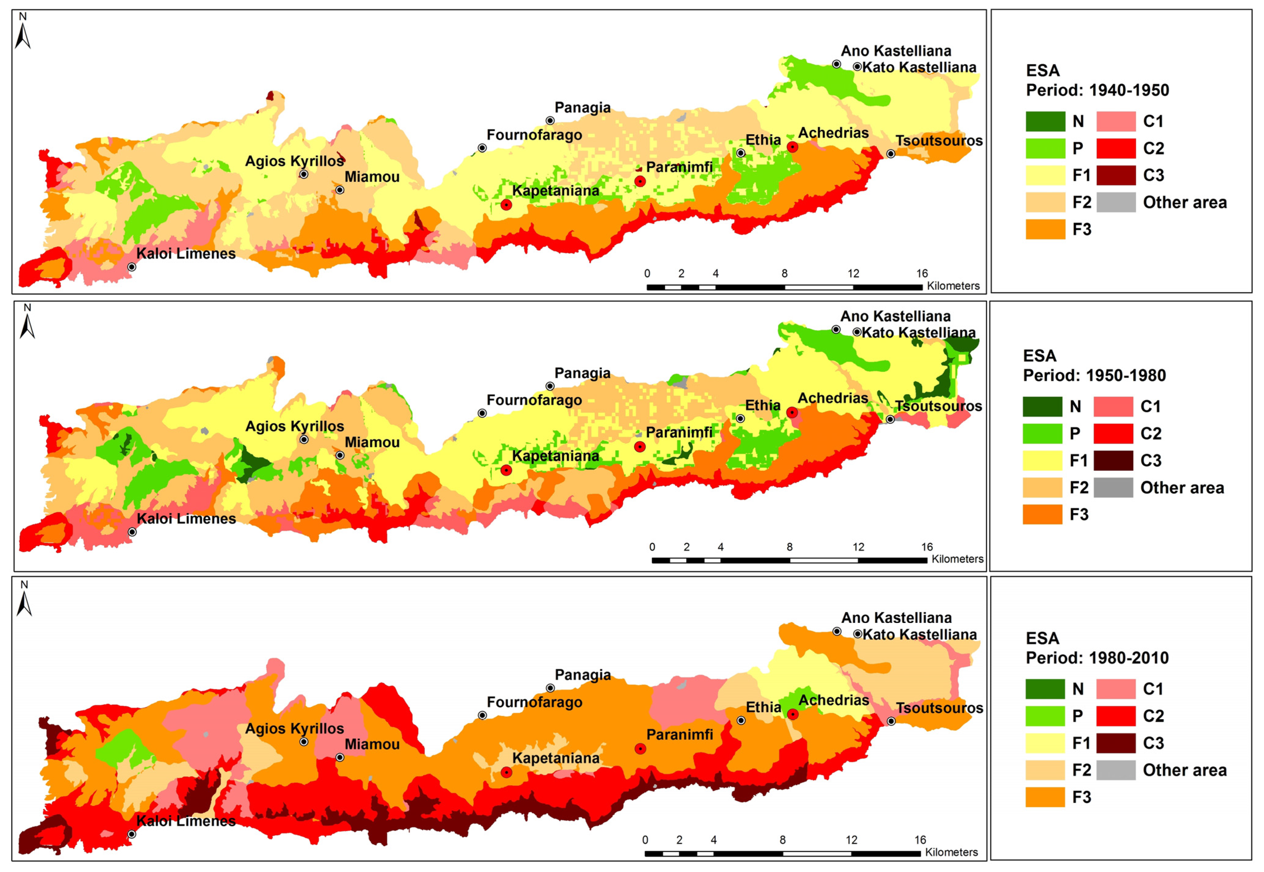
3.3. Regulation of Hydrological Processes and Desertification Risk

Based on the assessment of surface water runoff estimated by the PESERA model, the Asteroussia Mountains were basically characterized as adequately regulating water runoff and hydrological processes (Figure 5) during the first study period (before 1950), as the classes of very-high and high ability (amount of rainfall infiltrating into the soil R > 95% and R = 80%–95%, respectively) in regulating hydrological processes covered 70.6% and 24.0% of the total area, respectively. Low or moderate ability (R < 75%, R = 75%–85%, respectively) in regulating hydrological processes were found only in 2.2% and 3.2% of the total area, respectively. In the following “traditional-husbandry state” period (1950–mid-1980s), this function has deteriorated due to increased number of animals causing reduction of plant cover that favored higher amounts of surface water runoff. Areas characterized as moderately regulating hydrological processes increased from 3.2% in the “traditional-husbandry state” period to 66.1% in the subsequent “subsidized husbandry state” period. Areas characterized with very high or high ability to regulate water runoff and hydrological processes have decreased from 94.6% in the first period to 33.9% in the last period.
Land desertification of Asteroussia Mountains is a major land degradation issue due to steep topography, shallow soils, adverse climatic conditions and land mismanagement favoring high erosion rates. As Figure 6 shows, the risk of desertification was a severe problem in the past and has become even worse in the last decades. “Fragile” areas (sub-types F1, F2, and F3) covered 79.1% of the total area (Table 4) during the period before 1950. These areas have decreased in the following “traditional-husbandry state” period to 71.1% and 54.8% in next “subsidized husbandry state” period. Sensitive areas to desertification classified as “critical” (sub-type C1, C2, and C3) covered only 12.3% of the total area before 1950. Such areas were mainly identified in the south-facing slopes of Asteroussia Mountains. Critical areas have increased in the subsequent periods by land changes from the “fragile” to the “critical” status owing to the increased soil erosion and the more intensive exploitation of the land caused by overgrazing. Critical land to desertification has increased to 12.6% and 43.2% in the periods 1950–mid-1980s and mid-1980s–2010, respectively.
Figure 5. Distribution of hydrological processes regulation classes based on the PESERA model estimated for the study periods (before 1950: upper, 1950–mid-1980s: middle, and mid-1980s–2010: lower).
Land 04 00541 g005
Table 4. Distribution of the eight classes of environmentally sensitive areas to desertification in Asteroussia Mountains during the study periods [31].
Type of ESABefore 19501950–mid-1980Mid-1980–2010
Area (ha)Area (%)Area (ha)Area (%)Area (ha)Area (%)
Non affected (N)2.20.0713.61.90.00.0
Potentially(P)3239.88.43524.29.2673.01.8
Fragile (F1)13,318.434.713,885.436.11530.14.0
Fragile (F2)10,109.126.39917.925.84968.112.9
Fragile (F3)6959.418.15332.713.914,577.837.9
Critical (C1)1738.44.52435.36.34661.912.1
Critical (C2)2903.87.62436.86.38685.522.6
Critical (C3)91.40.20.00.03266.18.5
Other area66.40.2182.80.566.40.2
TOTAL38,428.8100.038,428.8100.038,428.8100.0
Figure 6. Distribution of environmentally sensitive areas (ESAs, Table 4) to desertification of Asteroussia Mountains study site for the study periods (before 1950: upper, 1950–mid-1980s: middle, and mid-1980s–2010: lower).
Land 04 00541 g006

4. Discussion

Sustainable grazing was a long-established practice in Asteroussia, as in other Mediterranean marginal areas, as it was the only way of securing the future of a household. Land resources enabling grazing were the major assets of the households that provided the means for living. Grazing practices and livelihoods in general, as practiced in the early 1950s, are considered as fairly sustainable with respect to protection of land resources from erosion and desertification. The stocking rate during the early 1950s was lower than 0.6 animals per hectare with a rangeland stocking carrying capacity amounting to one animal per hectare. Economic and technological changes during the subsequent “traditional-husbandry state” period (1950–mid-1980s) provided the alternative of increasing production to increase income, an option that led to intensive grazing (stocking rate 0.9–1.6 animals per hectare) with subsequent degradation of the land. The reduced land productivity in turn led to an increased dependence on purchased fodder, paving the way for the widespread decoupling of production from land productivity that occurred in the following period.
The introduction of agricultural subsidies was the most critical event in the turnaround between the second and the third studied interval. The development path during the third “subsidized husbandry state” period (mid-1980–2010) can be seen as a double-partial decoupling: production became partially decoupled from local land productivity as it became increasingly dependent on purchased fodder from other areas. In addition, income became partially decoupled from animal production, as a significant portion of it was provided in the form of subsidies. At the same time, land degradation was only partly decoupled from grazing in the area. Although increasing animal numbers was made possible through purchased fodder, the reliance on grazing was not eliminated. Along with the breakdown of transhumance practices, the rising number of grazing animals (stocking rate 2.0–2.3 animals per hectare) exerted an ever growing pressure on the vegetation. The increasing use of fodder substitutes has depressed pasture productivity without generating incentives for preserving or restoring soil and vegetation [48]. This resulted in the accelerated dependence on purchased fodder, enhancing the decoupling of production and income from land resources. However, the increase of number of animals was an apparently rational decision in strictly economic terms, even though this decision was against environmental regulations and experts warning for environmental protection. The grazing intensity was usually beyond the carrying capacity of land leading to accelerated soil erosion and land desertification. The combination of the factors: (a) rising fodder prices; (b) stagnating milk prices; (c) lack of cash and credit; and (d) grazing intensity exceeding by far the carrying capacity of the landscape that is being persistently degraded during the last decades, appears as an important challenge for the Asteroussia pastoral system.

5. Conclusions

The present study pointed out the importance of preserving long-term sustainable practices in Mediterranean pastoral landscapes. Our results show that overgrazing in land sensitive to soil erosion leads to a loss of soil, restricting water storage capacity and vegetation performance. Areas with relatively shallow soils and limiting subsurface layers, such as bedrock, are very sensitive to land degradation. Any loss of soil drastically reduces plant growth and results in adverse economic conditions of the people living in such areas leading to land abandonment and/or desertification risk. The ongoing crisis made reliance on purchased fodder problematic, thus leading to a renewed debate on livestock size reduction, taking into account land potential. Conservation policies and practices of graze land against overgrazing could be implemented in Mediterranean areas sensitive to desertification as an indirect environmental measure mitigating soil erosion.

Acknowledgments

The research described in this paper was conducted within the framework of the EC-DG RTD, 7th Framework Research Programme (sub-priority ENV-2009-2.1.3.2), Research on Desertification Process and Land Degradation, project LEDDRA (243857): Land and Ecosystem Degradation and Desertification: Assessing the Fit of Responses. The financial support by the European Commission is greatly acknowledged. Helen Briassouli, Thanasis Kizos, Theodoros Iosifides and Minas Metaxakis are acknowledged for fruitful discussions and sharing information on the area.

Author Contributions

C.K., V.D., M.K., K.K., and P.V. contributed to the design, data collection and analysis, and writing of the manuscript. L.S. contributed to the analysis of data and writing of the manuscript.

Conflicts of Interest

The authors declare no conflict of interest.

References

  1. Ibáñez, J.; Martínez, J.; Schnabel, S. Desertification due to overgrazing in a dynamic commercial livestock-grass-soil system. Ecol. Model. 2007, 205, 277–288. [Google Scholar] [CrossRef]
  2. Angassa, A. Effects of grazing intensity and bush encroachment on herbaceous species and rangeland condition in southern Ethiopia. Land Degrad. Dev. 2014, 25, 438–451. [Google Scholar] [CrossRef]
  3. Greenwood, K.L.; McKenzie, B.M. Grazing effects on soil physical properties and the consequences for pastures: A review. Aust. J. Exp. Agric. 2001, 41, 1231–1250. [Google Scholar] [CrossRef]
  4. Mulholland, B.; Fullen, M.A. Cattle trampling and soil compaction on loamy sands. Soil Use Manag. 1991, 7, 189–193. [Google Scholar] [CrossRef]
  5. Climo, W.J.; Richardson, M.A. Factors affecting the susceptibility of 3 soils in the Manawatu to stock treading. New Zeal. J. Agric. Res. 1984, 27, 247–253. [Google Scholar] [CrossRef]
  6. Drewry, J.J.; Paton, R.J. Effects of sheep treading on soil physical properties and pasture yield of newly sown pastures. New Zeal. J. Agric. Res. 2005, 48, 39–46. [Google Scholar] [CrossRef]
  7. Greenwood, K.L.; Macleod, D.; Hutchinson, K.J. Long-term stocking rate effects on soil physical properties. Aust. J. Exp. Agric. 1997, 37, 413–419. [Google Scholar] [CrossRef]
  8. Di, H.J.; Cameron, K.C.; Milne, J.; Drewry, J.J.; Smith, N.P.; Hendry, T.; Moore, S.; Reijnen, B. A mechanical hoof for simulating animal treading under controlled conditions. New Zeal. J. Agric. Res. 2001, 44, 111–116. [Google Scholar] [CrossRef]
  9. Cerdà, A.; Lavee, H. The effect of grazing on soil and water losses under arid and Mediterranean climates. Implications for desertification. Pirineos 1999, 153–154, 159–174. [Google Scholar] [CrossRef]
  10. Hiernaux, P.; Bielders, C.L.; Valentine, C.; Bationo, A.; Fernadez-Rivera, S. Effects of livestock grazing on physical and chemical properties of sandy soils in Sahelian rangelands. J. Arid Environ. 1999, 41, 231–245. [Google Scholar] [CrossRef]
  11. Manzano, M.G.; Navar, J. Processes of desertification by goats heavy grazing in the Tamaulipan thornscrub (matorral) in north-eastern Mexico. J. Arid Environ. 2000, 44, 1–17. [Google Scholar] [CrossRef]
  12. Van de Ven, T.A.M.; Fryrear, D.W.; Spaan, W.P. Vegetation characteristics and soil loss by wind. J. Soil Water Conserv. 1989, 44, 47–349. [Google Scholar]
  13. Francis, C.F.; Thornes, J.B. Runoff hydrographs from three Mediterranean vegetation cover types. In Vegetation and Erosion: Processes and Environments; Thornes, J.B., Ed.; John Wiley & Sons: Chichester, UK, 1990; pp. 363–384. [Google Scholar]
  14. Kirkby, M.J.; Le Bissonais, Y.; Coulthard, T.J.; Daroussin, J.; McMahon, M.D. The development of land quality indicators for soil degradation by water erosion. Agric. Ecosyst. Environ. 2000, 81, 125–136. [Google Scholar] [CrossRef]
  15. Papanastasis, V.P. Livestock grazing in Mediterranean ecosystems: An historical and policy perspective. In Ecological Basis of Livestock Grazing in Mediterranean Ecosystems, Proceedings of the EU International Workshop, Thessaloniki, Greece, 23–25 October 1997; Papanastasis, V.P., Peter, D., Eds.; European Commission Science, Research and Development: Bruxelles, Belgium, 1998; pp. 5–9. [Google Scholar]
  16. Schnabel, S.; Lavado, J.F. Erosión del suelo y procesos hidrológicos en dehesas del sur-oeste español. In La Red de Estaciones Experimentales de Seguimiento y Evaluación de la Desertificación (RESEL); Rojo, L., Ed.; Actividades y Resultados 1995–2004; Ministerio de Medio Ambiente: Madrid, Spain, 2008; pp. 34–57. [Google Scholar]
  17. Papanastasis, V.P. Overgrazing: An issue associated with desertification. In DIS4ME: Desertification Indicators System for Mediterranean Europe. Available online: http://www.kcl.ac.uk/projects/desertlinks/accessdis4me.htm (accessed on 28 May 2015).
  18. Polyzos, N. Exploitation of rangelands: Actual situation, problems and perspectives. Anim. Sci. Rev. 1991, 7, 154–167. (In Greek) [Google Scholar]
  19. Zervas, G. Quantifying and optimizing grazing regimes in Greek mountain systems. J. Appl. Ecol. 1998, 35, 983–986. [Google Scholar] [CrossRef]
  20. Tsiourlis, G.M.; Kasapidis, P.; Parmakelis, A.; Dretakis, M. Effects of grazing on the structure of phryganic ecosystems in the Asterousia mountain of Crete, Greece. In Ecological Basis of Livestock Grazing in Mediterranean Ecosystems, Proceedings of the International Workshop, Thessaloniki, Greece, 23–25 October 1997; Papanastasis, V.P., Peter, D., Eds.; European Commission Science, Research and Development: Bruxelles, Belgium, 1998; pp. 94–97. [Google Scholar]
  21. Volanis, M.; Stefanakis, A.; Hadjigeorgiou, I.; Zoiopoulos, P. Supporting the extensive dairy sheep smallholders of the semi-arid region of Crete through technical intervention. Trop. Anim. Health Prod. 2007, 39, 325–334. [Google Scholar] [CrossRef] [PubMed]
  22. Hadjigeorgiou, I.; Vallerand, F.; Tsimpoukas, K.; Zervas, G. The socio-economics of sheep and goat farming in Greece and the implications for future rural development. Opt. Méditerr. Sér. B 2002, 39, 83–93. [Google Scholar]
  23. Papanastasis, V.P.; Bautista, S.; Chouvardas, D.; Mantzanas, K.; Papadimitriou, M.; Mayor, A.G.; Koukioumi, P.; Papaioannou, A.; Vallejo, R.V. Comparative assessment of goods and services provided by grazing regulation and reforestation in degraded Mediterranean rangelands. Land Degrad. Dev. 2015. [Google Scholar] [CrossRef]
  24. Middleton, N.; Thomas, D. World Atlas of Desertification; United Nations Environment Programme (UNEP): London, UK, 1997; p. 182. [Google Scholar]
  25. Rubio, J.L.; Bochet, E. Desertification indicators as diagnosis criteria for desertification risk assessment in Europe. J. Arid Environ. 1998, 39, 113–120. [Google Scholar] [CrossRef]
  26. Simeonakis, A.; Calvo-Cases, E.; Arnau-Rosalen, A. Land use change and land degradation in southeastern Mediterranean Spain. Environ. Manag. 2007, 40, 80–94. [Google Scholar] [CrossRef] [PubMed]
  27. Thornes, J.B. Stability and instability in the management of Mediterranean desertification. In Environmental Modelling: Finding Simplicity in Complexity; Wainwright, J., Mulligan, M., Eds.; John Wiley & Sons: Chichester, UK, 2004; pp. 303–315. [Google Scholar]
  28. Ali, R.R.; El Baroudy, A.A. Use of GIS in mapping the environmental sensitivity to desertification in Wadi El Natrun depression, Egypt. Aust. J. Basic Appl. Sci. 2008, 2, 157–164. [Google Scholar]
  29. Farajzabeh, M.; Egbal, M.N. Evaluation of MEDALUS model for Desertification Hazard Zonation using GIS; study area: Iyzad Khast Plain, Iran. Pak. J. Biol. Sci. 2007, 10, 2622–1630. [Google Scholar] [CrossRef]
  30. Salvati, L.; Bajocco, S. Land sensitivity to desertification across Italy: Past, present, and future. Appl. Geogr. 2011, 31, 223–231. [Google Scholar] [CrossRef]
  31. Kosmas, C.; Kirkby, M.; Geeson, N. Manual on: Key Indicators of Desertification and Mapping Environmentally Sensitive Areas to Desertification; EUR 18882; European Commission-Energy, Environment and Sustainable Development: Brussels, Belgium, 1999; p. 87. [Google Scholar]
  32. Basso, F.; Bove, E.; Dumontet, S.; Ferrara, A.; Pisante, M.; Quaranta, G. Evaluating environmental sensitivity at the basin scale through the use of geographic information systems and remotely sensed data: An example covering the Agri basin—Southern Italy. Catena 2000, 40, 19–35. [Google Scholar] [CrossRef]
  33. Brandt, J. Desertification Information System to Support National Action Programmes in the Mediterranean (DISMED). In DIS4ME, Desertification Indicator System for Mediterranean Europe; Available online: http://www.unibas.it/desertnet/dis4me/using_dis4me/dismed.htm (accessed on 18 May 2015).
  34. Brandt, J.; Geeson, N.; Imeson, A. A Desertification Indicator System for Mediterranean Europe. Available online: http://www.kcl.ac.uk/projects/desertlinks/accessdis4me.htm (accessed on 19 May 2015).
  35. Iosifides, T.; Politidis, T. Socio-economic dynamics, local development and desertification in western Lesvos, Greece. Local Environ. 2005, 10, 487–499. [Google Scholar] [CrossRef]
  36. Soil Survey Staff. Soil Taxonomy: A Basic System of Soil Classification for Making and Interpreting Soil Surveys; USDA-SCS Agric. Handbook 436; U.S. Government Printing Office: Washington, DC, USA, 1975; p. 754. [Google Scholar]
  37. ESRI. ArcMap Version 9.2. User Manual ESRI; ESRI: Redlands, CA, USA, 2006. [Google Scholar]
  38. CORINE. Available online: http://www.eea.europa.eu/publications/COR0-part2 (accessed on 12 November 2010).
  39. Kirkby, M.J.; Bull, L.J.; Poesen, J.; Nachtergaele, J.; Vandekerckhove, L. Observed and modelled distributions of channel and gully heads—With examples from S.E. Spain and Belgium. Catena 2003, 50, 415–434. [Google Scholar] [CrossRef]
  40. Kirkby, M.J.; Jones, R.J.A.; Irvine, B.; Gobin, A; Govers, G.; Cerdan, O.; van Rompaey, A.J.J.; Le Bissonnais, Y.; Daroussin, J.; King, D.; et al. Pan-European Soil Erosion Risk Assessment: The PESERA Map, Version 1 October 2003—Explanation of Special Publication ISPRA 2004 No. 73 (S.P.I.04.73); European Soil Bureau Research Report No. 16, EUR 21176, 18 pp. and 1 Map in ISO B1 Format; Williams, J.R., Sharpley, A.N., Eds.; Office for Official Publications of the European Communities: Luxembourg, 1989. [Google Scholar]
  41. Kosmas, C.; Quaranta, G. Assessment Methodologies of Responses to LEDD in Cropland—Case Study-Specific. Deliverable Number Code: 10(D122). Available online Leddra.aegean.gr (accessed on 18 May 2015).
  42. Tsara, M.; Kosmas, C.; Kirkby, M.; Kosma, D.; Yassoglou, N. An evaluation of the PESERA soil erosion model and its application to a case study in Zakynthos, Greece. Soil Use Manag. 2005, 21, 377–385. [Google Scholar] [CrossRef]
  43. Allen, R.G.; Pereira, L.S.; Raes, D.; Smith, M. Crop Evapotranspiration: Guidelines for Computing Crop Requirements; Irrigation and Drainage Paper No. 56; FAO: Rome, Italy, 1998; p. 300. [Google Scholar]
  44. Parson, A.; Abrahams, A.D.; Simanton, J.R. Microtopography and soil surface materials on semi-arid piedmont hillslopes, southern Arizona. J. Arid Environ. 1992, 22, 107–115. [Google Scholar]
  45. Salvati, L.; Mancino, G.; De Zuliani, E.; Sateriano, A.; Zitti, M.; Ferrara, A. An expert system to evaluate environmental sensitivity: A local-scale approach to desertification risk. Appl. Ecol. Environ. Res. 2013, 11, 611–627. [Google Scholar] [CrossRef]
  46. Kizos, T.; Detsis, V.; Iosifides, T.; Metaxakis, M. Social capital and social-ecological resilience in the Asteroussia Mountains, southern Crete, Greece. Ecol. Soc. 2014, 19, 40:1–40:11. [Google Scholar] [CrossRef]
  47. Kairis, O.; Karavitis, C.; Kounalaki, A.; Kosmas, C.; Salvati, L. Exploring the impact of overgrazing on soil erosion and land degradation in a dry Mediterranean agro-forest landscape (Crete, Greece). Arid Land Res. Manag. 2015, 29, 360–374. [Google Scholar] [CrossRef]
  48. Kizos, T.; Plieninger, T.; Schaich, H. “Instead of 40 Sheep there are 400”: Traditional grazing practices and landscape change in western Lesvos, Greece. Landsc. Res. 2013, 38, 476–474. [Google Scholar] [CrossRef]

