Agricultural Land Conversion, Land Economic Value, and Sustainable Agriculture: A Case Study in East Java, Indonesia

 ,
, 
Abstract
:
1. Introduction
2. Materials and Methods
2.1. Agricultural Land Conversion in Indonesia
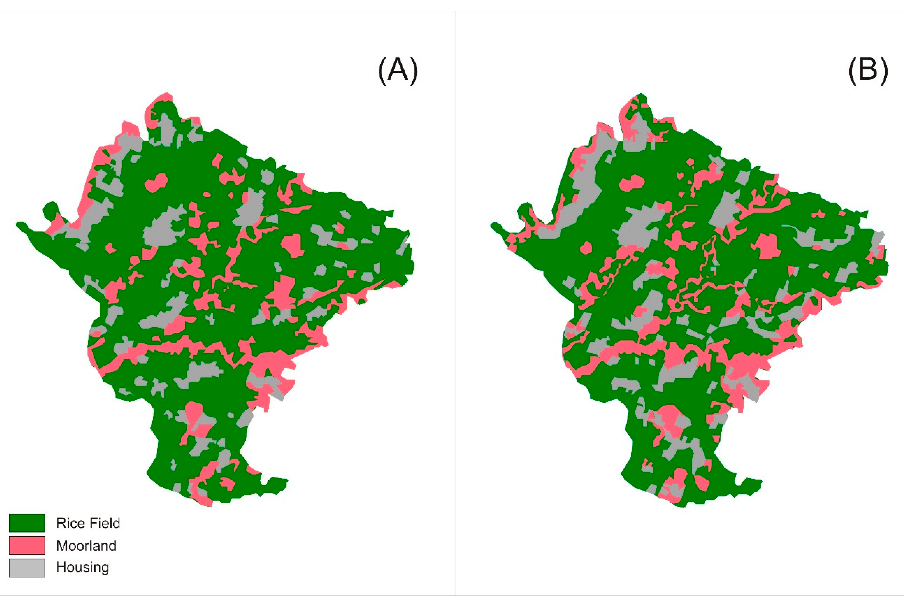
2.2. Study Area
2.3. Data
2.4. Econometric Model and Estimation Procedures
3. Results
3.1. Land Economic Value
3.2. Factors Affecting Land Economic Value
4. Discussion
4.1. Land Economic Value and Agricultural Land Conversion
4.2. Factors Affecting Land Economic Value
4.3. Policy Implications
- The current incentive mechanism, contained in UU No. 41 Tahun 2009, should be focused on farmers in peri-urban areas, specifically those who choose to remain in farming, even at the expense of profit (peri-urban farmer), since the current incentive mechanism requires proactive and highly motivated farmers.
- There should be an effort to encourage farmers to cultivate crops that are suitable to the land characteristics. Cultivating high-value crops actually increases land value. However, land quality (fertility) will be degraded if the land is forced to produce crops that are basically unsuitable for its characteristics [68,69]. This is one of the major causes of land quality degradation. Since land fertility is proven to positively affect land value, both theoretically and empirically, uncontrolled land quality degradation will sacrifice the sustainability of agriculture itself. Thus, it is important to conduct a detailed analysis of land suitability in relation to cropping patterns, especially in rural areas. This should be the main agenda in the framework of increasing the agricultural land economic value in rural areas.
- The growing number of commercial farmers in rural areas should be supported by granting them access to timely information regarding market conditions and farm technology. Commercial farmers tend to be more responsive to new information and technology. Thus, improving their access to technology will further improve their farming productivity [70,71].
5. Conclusions
- The data used in this study came only from two villages representing peri-urban and rural areas, respectively, and they also had only one period of observation. The information gained will be useful by adding a spatial and temporal dimension to the data. Thus, we leave this endeavor to the future studies.
- The peri-urban land use studied in this study consisted only of housing. Although this is the major form of peri-urban land use in our study area, future studies will produce important results by incorporating other forms of peri-urban land-use.
- We have found a puzzling anomaly between food cropping in rural and peri-urban areas, especially with the output price being different. The information that we collected in this study is not adequate to explain this anomaly. Thus, we leave this endeavor for future research.
- Systematically identifying the characteristics of peri-urban farmers and thoroughly exploring what motivates them to remain in farming and retaining their farmland;
- Identifying the characteristics of commercial farmers in rural areas, and tracing how they acquire information regarding market conditions and technology that that they use in making farm decisions; and
- Conducting an agricultural land suitability analysis and measuring the economic benefits of cultivating crops that are suitable for the land characteristics.
Author Contributions
Funding
Acknowledgments
Conflicts of Interest
References
- Sitko, N.J.; Jayne, T.S. Structural transformation or elite land capture? The growth of “emergent” farmers in Zambia. Food Policy 2014, 48, 194–202. [Google Scholar] [CrossRef]
- Muyanga, M.; Jayne, T.S.; Burke, W.J. Pathways into and out of Poverty: A Study of Rural Household Wealth Dynamics in Kenya. J. Dev. Stud. 2013, 49, 37–41. [Google Scholar] [CrossRef]
- Li, J. Land sale venue and economic growth path: Evidence from China ’ s urban land market. Habitat Int. 2014, 41, 307–313. [Google Scholar] [CrossRef]
- Azadi, H.; Ho, P.; Hasfiati, L. Agricultural land conversion drivers: A comparison between less developed, developing and developed countries. Land Degrad. Dev. 2011, 22, 596–604. [Google Scholar] [CrossRef]
- Deloitte. The Food Value Chain A Challenge for the Next Century; Deloitte: London, UK, 2013. [Google Scholar]
- Karunakaran, N. Cropping Pattern and Land Degradation in Kasaragod, Kerala. Rajagiri J. Soc. Dev. 2014, 6, 5–20. [Google Scholar]
- Singh, P.; Nair, A. Environmental Sustainability of Cropping Patterns in Gujarat; IRMA Working Paper Series; Institute of Rural Management Anand: Gujarat, India, 2012. [Google Scholar]
- Kutywawo, D.; Chemura, A.; Chagwesha, T. Soil Quality and Cropping Patterns as A ffected by iIrigation Water Quality in Mutema Irrigation. In 13th WaterNet /WARFSA/GWP-SA International Symposium on Integrated Water Resource Management (IWRM); Global water Partnership-South Africa: Johannesburg, South Africa, 2012. [Google Scholar]
- Schneider, A.; Woodcook, C.E. Compact, Dispersed, Fragmented, Extensive? A Comparison of Urban Growth in Twenty-five Global Cities using Remotely Sensed Data, Pattern Metrics and Census Information. Urban Stud. 2008, 45, 659–692. [Google Scholar] [CrossRef]
- Simon, D. Urban Environtments: Issues on the Peri-Urban Fringe. Annu. Rev. Environ. Resour. 2008, 33, 167–185. [Google Scholar] [CrossRef]
- Webster, D. On the Edge: Shaping the Future of Peri-urban East Asia; Stanford University/Asia Pasific Research Center: Stanford, CA, USA, 2001. [Google Scholar]
- Malaque, I.R.; Yokohari, M. Urbanization process and the changing agricultural landscape pattern in the urban fringe of Metro Manila, Philippines. Environ. Urban. 2007, 19, 191–206. [Google Scholar] [CrossRef] [Green Version]
- Yokohari, M.; Takeuchi, K.; Watanabe, T.; Yokota, S. Beyond greenbelts and zoning - A new planning concept for the environment of Asian mega-cities. Landsc. Urban Plan. 2000, 47, 159–171. [Google Scholar] [CrossRef]
- Ives, C.D.; Kendal, D. Values and attitudes of the urban public towards peri-urban agricultural land. Land Use Policy 2013, 34, 80–90. [Google Scholar] [CrossRef]
- Tassinari, P.; Torreggiani, D.; Benni, S. Dealing with agriculture, environment and landscape in spatial planning: A discussion about the Italian case study. Land Use Policy 2013, 30, 739–747. [Google Scholar] [CrossRef]
- Zasada, I. Multifunctional peri-urban agriculture—A review of societal demands and the provision of goods and services by farming. Land Use Policy 2011, 28, 639–648. [Google Scholar] [CrossRef]
- Zezza, A.; Tasciotti, L. Urban agriculture, poverty, and food security: Empirical evidence from a sample of developing countries. Food Policy 2010, 35, 265–273. [Google Scholar] [CrossRef]
- Bryld, E. Potentials, problems, and policy implications for urban agriculture in developing countries. Agric. Hum. Values 2003. [Google Scholar] [CrossRef]
- McGee, T.G. Building Liveable Cities in Asia in the Twenty-First Century Research and Policy Challenges for the Urban Future of Asia. Malays. J. Efnviron. Manag. 2010, 11, 14–28. [Google Scholar]
- Allen, A. Environmental planning and management of the peri-urban interface: Perspectives on an emerging field. Environ. Urban. 2003, 15, 135–148. [Google Scholar] [CrossRef]
- Douglass, M. A regional network strategy for reciprocal rural-urban linkages: an agenda for policy research with reference to Indonesia. Third World Plan. Rev. 1998, 20, 1. [Google Scholar] [CrossRef]
- North, D.C. Location Theory and Regional Economic Growth. J. Polit. Econ. 1955, 63, 243–258. [Google Scholar] [CrossRef]
- Irwin, E.G.; Bockstael, N.E. Interacting agents, spatial externalities and the evolution of residential land use patterns. J. Econ. Geogr. 2002, 2, 31–54. [Google Scholar] [CrossRef]
- Irwin, E.G.; Bockstael, N.E. The evolution of urban sprawl: Evidence of spatial heterogeneity and increasing land fragmentation. Proc. Natl. Acad. Sci. USA 2007, 104, 33–46. [Google Scholar] [CrossRef] [PubMed]
- Imhoff, M.L.; Lawrence, W.T.; Stutzer, D.C.; Elvidge, C.D. A technique for using composite DMSP/OLS “city lights” satellite data to map urban area. Remote Sens. Environ. 1997, 61, 361–370. [Google Scholar] [CrossRef]
- Foley, J.A.; DeFries, R.; Asner, G.P.; Barford, C.; Bonan, G.; Carpenter, S.R.; Chapin, F.S.; Coe, M.T.; Daily, G.C.; Gibbs, H.K.; et al. Global Consequences of Land Use. Science 2005, 309, 570–574. [Google Scholar] [CrossRef] [PubMed] [Green Version]
- Kilian, S.; Antón, J.; Salhofer, K.; Röder, N. Impacts of 2003 CAP reform on land rental prices and capitalzation. Land Use Policy 2012, 29, 789–797. [Google Scholar] [CrossRef]
- Latruffe, L.; Le Mouël, C. Capitalization of government support in agricultural land prices: What do we know? J. Econ. Surv. 2009, 23, 659–691. [Google Scholar] [CrossRef]
- Feichtinger, P.; Salhofer, K. What do we know about the influence of agricultural support on agricultural land prices. In German Journal of Agricultural Economics; Swinnen, J., Knops, L., Eds.; Centre For European Policy Studies (CEPS): Brussels, Belgium, 2013; Volume 62, pp. 71–85. [Google Scholar]
- Ciaian, P.; Kancs, D.; Swinnen, J. The Impact of Decoupled Payments on Land Prices in the EU. In Land, Labour and Capital Markets in European Agriculture: Diversity Under a Common Policy; Swinnen, J., Knops, L., Eds.; Centre For European Policy Studies (CEPS): Brussels, Belgium, 2013; pp. 28–42. [Google Scholar]
- Milczarek-Andrzejewska, D.; Zawalińska, K.; Czarnecki, A. Land-use conflicts and the Common Agricultural Policy: Evidence from Poland. Land Use Policy 2018, 73, 423–433. [Google Scholar] [CrossRef]
- Alam, M.J. Rapid urbanization and changing land values in mega cities: implications for housing development projects in Dhaka, Bangladesh. Bandung J. Glob. South 2018, 5, 2. [Google Scholar] [CrossRef] [Green Version]
- Pribadi, D.O.; Pauleit, S. The dynamics of peri-urban agriculture during rapid urbanization of Jabodetabek Metropolitan Area. Land Use Policy 2015, 48, 13–24. [Google Scholar] [CrossRef]
- Firman, T.; Dharmapatni, I.A.I. The challenges to sustainable development in Jakarta metropolitan region. Habitat Int. 1994, 18, 79–94. [Google Scholar] [CrossRef]
- Firman, T. From ‘global city’ to ‘city of crisis’: Jakarta metropolitan region under economic turmoil. Habitat Int. 1999, 23, 447–466. [Google Scholar] [CrossRef]
- Firman, T. Rural to urban land conversion in Indonesia during boom and bust periods. Land Use Policy 2000, 17, 13–20. [Google Scholar] [CrossRef]
- Firman, T. The continuity and change in mega-urbanization in Indonesia: A survey of Jakarta-Bandung Region (JBR) development. Habitat Int. 2009, 33, 327–339. [Google Scholar] [CrossRef]
- Hudalah, D.; Firman, T. Beyond property: Industrial estates and post-suburban transformation in Jakarta Metropolitan Region. Cities 2012, 29, 40–48. [Google Scholar] [CrossRef]
- Agus, F. Irawan Agricultural Land Conversion As A Threat to Food Security and Environtmental Quality. J. Litbang Pertan. 2006, 25, 90–98. [Google Scholar]
- Irawan, B. Meningkatkan Efektivitas Kebijakan Konversi Lahan. Forum Penelit. Agro Ekon. 2008, 26, 116–131. [Google Scholar] [CrossRef]
- Government of Indonesia. Perlindungan Lahan Pertanian Berkelanjutan; Indonesian Ministry of Law and Human Rights: Jakarta, Indonesia, 2009; p. 24.
- BPS-Statistics of Jember Regency. Jember Regency in Figures; BPS Kabupaten Jember: Jember, Indonesia, 2017. [Google Scholar]
- Lima, A.C.R.; Hoogmoed, W.B.; Brussaard, L.; Sacco Dos Anjos, F. Farmers’ assessment of soil quality in rice production systems. NJAS Wagening. J. Life Sci. 2011, 58, 31–38. [Google Scholar] [CrossRef]
- Manganelli, B.; Murgante, B. The Dynamics of Urban Land Rent in Italian Regional Capital Cities. Land 2017, 6, 54. [Google Scholar] [CrossRef]
- Peerzado, M.B.; Magsi, H.; Sheikh, M.J. Land use conflicts and urban sprawl: Conversion of agriculture lands into urbanization in Hyderabad, Pakistan. J. Saudi Soc. Agric. Sci. 2018. [Google Scholar] [CrossRef]
- Kontgis, C.; Schneider, A.; Fox, J.; Saksena, S.; Spencer, J.H.; Castrence, M. Monitoring peri-urbanization in the greater Ho Chi Minh City metropolitan area. Appl. Geogr. 2014, 53, 377–388. [Google Scholar] [CrossRef]
- Wasilewski, A.; Krukowski, K. Land conversion for suburban housing: A study of urbanization around Warsaw and Olsztyn, Poland. Environ. Manag. 2004, 34, 291–303. [Google Scholar] [CrossRef] [PubMed]
- Phuc, N.Q.; Westen, A.C.M.; Zoomers, A. Agricultural land for urban development: The process of land conversion in Central Vietnam. Habitat Int. 2014, 41, 1–7. [Google Scholar] [CrossRef]
- Xiao, R.; Liu, Y.; Huang, X.; Shi, R.; Yu, W.; Zhang, T. Exploring the driving forces of farmland loss under rapidurbanization using binary logistic regression and spatial regression: A case study of Shanghai and Hangzhou Bay. Ecol. Indic. 2018, 95, 455–467. [Google Scholar] [CrossRef]
- Nguyen, T.H.T.; Tran, V.T.; Bui, Q.T.; Man, Q.H.; de Vries Walter, T. Socio-economic effects of agricultural land conversion for urban development: Case study of Hanoi, Vietnam. Land Use Policy 2016, 54, 583–592. [Google Scholar] [CrossRef]
- Brown, K.; Barrows, R. The impact of soil conservation investments on land prices. Am. J. Agric. Econ. 1985, 67, 943–947. [Google Scholar]
- Maddison, D. A hedonic analysis of agricultural land prices in England and Wales. Eur. Rev. Agric. Econ. 2000, 27, 519–532. [Google Scholar] [CrossRef]
- Maddison, D.J. A spatio-temporal model of farmland values. J. Agric. Econ. 2009, 60, 171–189. [Google Scholar] [CrossRef]
- Troncoso, J.L.; Aguirre, M.; Manriquez, P.; Labarra, V.; Ormazábal, Y. Influence of physical attributes on the price of land: the case of the Province of Talca, Chile. Cienc. Investig. Agrar. 2010, 37, 105–112. [Google Scholar] [CrossRef] [Green Version]
- Yoo, J.; Simonit, S.; Connors, J.P.; Maliszewski, P.J.; Kinzig, A.P.; Perrings, C. The value of agricultural water rights in agricultural properties in the path of development. Ecol. Econ. 2013, 91, 57–68. [Google Scholar] [CrossRef]
- Chicoine, D.L. Farmland Values at the Urban Fringe: An Analysis of Sale Prices. Land Econ. 1981, 57, 353–362. [Google Scholar] [CrossRef]
- Sklenicka, P.; Molnarova, K.; Pixova, K.C.; Salek, M.E. Factors affecting farmland prices in the Czech Republic. Land Use Policy 2013, 30, 130–136. [Google Scholar] [CrossRef]
- Kellerman, A. Rent from Agricultural Land Around Metropolitan Areas. Geogr. Anal. 1978, 10, 1–12. [Google Scholar] [CrossRef]
- Choumert, J.; Phélinas, P. A Hedonic Analysis of Agricultural Land Values in a Gm Soybean Area of Argentina. In Proceedings of the EAAE 2014 Congress ‘Agri-Food and Rural Innovations for Healthier Societies’, Ljubljana, Slovenia, 26–29 August 2014; pp. 1–14. [Google Scholar]
- Banski, J. Changes in agricultural land ownership in Poland in the period of the market economy. Agric. Econ. 2011, 57, 93–101. [Google Scholar] [Green Version]
- Dirgasová, K.; Bandlerová, A.; Lazíková, J. Factors affecting the price of agricultural land in Slovakia. J. Cent. Eur. Agric. 2017, 18, 291–304. [Google Scholar] [CrossRef] [Green Version]
- Joshi, J.; Ali, M.; Berrens, R.P. Valuing farm access to irrigation in Nepal: A hedonic pricing model. Agric. Water Manag. 2017, 181, 35–46. [Google Scholar] [CrossRef]
- Nivens, H.D.; Kastens, T.L.; Dhuyvetter, K.C.; Featherstone, A.M.; Allen, M.; Nivens, H.D.; Kastens, T.L.; Dhuyvetter, K.C.; Featherstone, A.M. Using Satellite Imagery in Predicting Kansas Farmland Values Linked references are available on JSTOR for this article: Using Satellite Imagery in Predicting Kansas Farmland Values. J. Agric. Resour. Econ. 2002, 27, 464–480. [Google Scholar]
- Nickerson, C.; Morehart, M.; Kuethe, T.; Beckman, J.; Ifft, J.; Williams, R. Trends in U.S. Farmland Values and Ownership. USDA Econ. Inf. Bull. 2012, 92, 48. [Google Scholar]
- Choumert, J.; Phélinas, P. Determinants of agricultural land values in Argentina. Ecol. Econ. 2015, 110, 134–140. [Google Scholar] [CrossRef] [Green Version]
- Kocur-bera, K. Determinants of agricultural land price in Poland—A case study covering a part of the Euroregion Baltic. Cah. Agric. 2016. [Google Scholar] [CrossRef]
- Yagi, H.; Garrod, G. The future of agriculture in the shrinking suburbs: The impact of real estate income and housing costs. Land Use Policy 2018, 76, 812–822. [Google Scholar] [CrossRef]
- Vasu, D.; Srivastava, R.; Patil, N.G.; Tiwary, P.; Chandran, P.; Kumar Singh, S. A comparative assessment of land suitability evaluation methods for agricultural land use planning at village level. Land Use Policy 2018, 79, 146–163. [Google Scholar] [CrossRef]
- Akinci, H.; Özalp, A.Y.; Turgut, B. Agricultural land use suitability analysis using GIS and AHP technique. Comput. Electron. Agric. 2013, 97, 71–82. [Google Scholar] [CrossRef]
- Zhou, J.; Cheng, C.; Kang, L.; Sun, R. Integration and Analysis of Agricultural Market Information Based on Web Mining. IFAC-PapersOnLine 2018, 51, 778–783. [Google Scholar] [CrossRef]
- Ziolkowska, J.R. Economic value of environmental and weather information for agricultural decisions—A case study for Oklahoma Mesonet. Agric. Ecosyst. Environ. 2018, 265, 503–512. [Google Scholar] [CrossRef]
| 1 | Many house renters in the peri-urban area are college students who rent houses in groups to reduce the average rental per person. Other house renters are typically small families who prefer smaller to larger houses. |
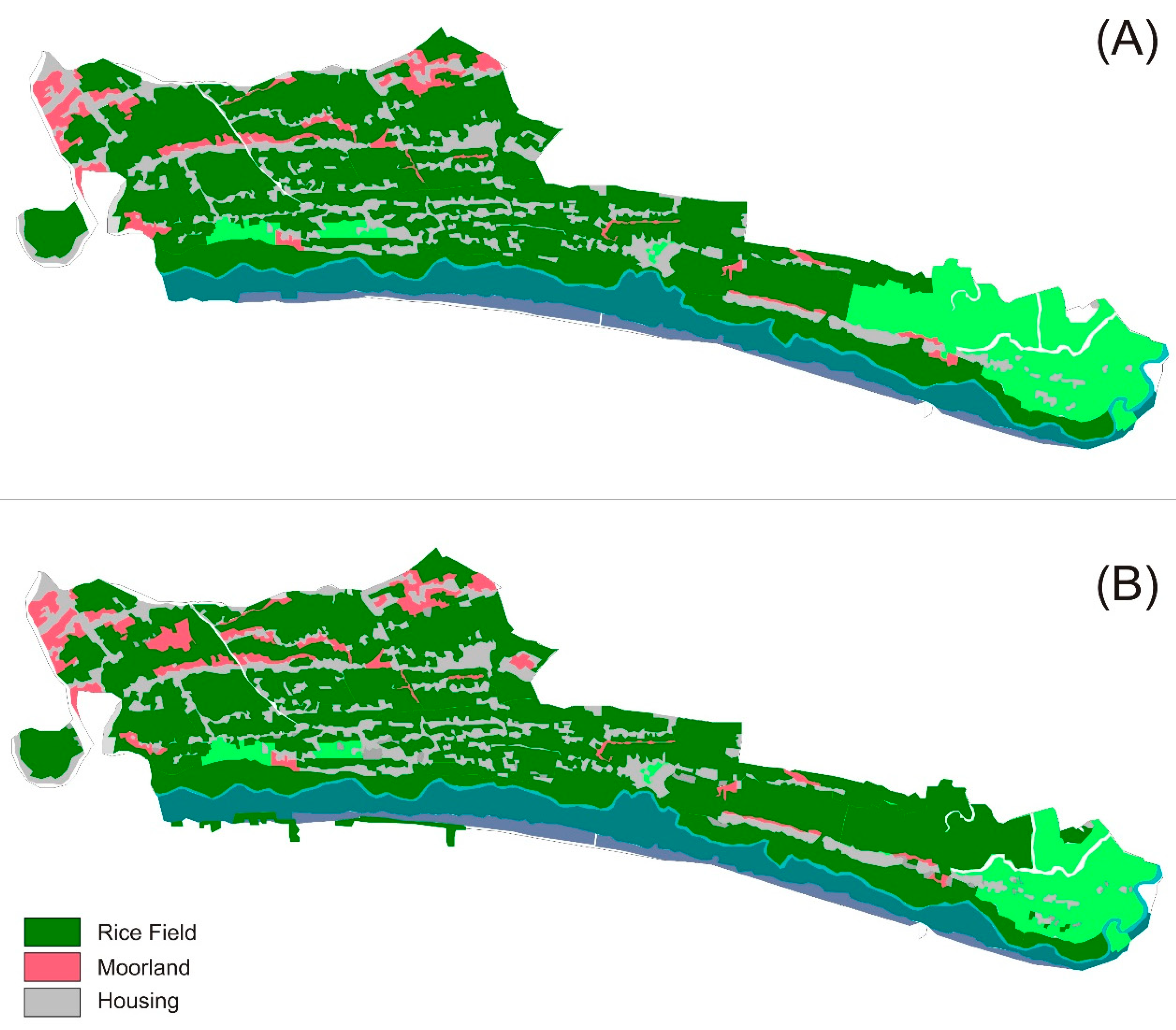
| 2 | In this study, we do not systematically assess the impact of urbanization on agricultural activities in the peri-urban area. However, based on our observation, new housing developments degrade the quality of irrigation infrastructures. Moreover, the pollution from urban activities (especially household) lead to decreasing water quality. Furthermore, many farmers reported that it is difficult to find labor for their agricultural activities, due to the change in employment structure. |


| Variable | Code | Unit | Full Sample | Kepanjen | Antirogo | |||
|---|---|---|---|---|---|---|---|---|
| Mean | S.D. | Min. | Max. | Mean | Mean | |||
| Land area | L.area | m2 | 4005 | 2515 | 1000 | 10,000 | 4211 | 3800 |
| Distance to irrigation | Irrigation | M | 1047 | 1681 | 0 | 5000 | 42 | 2053 |
| Distance to nearest market | Market | M | 4250 | 1305 | 2000 | 8000 | 4080 | 4420 |
| Distance to road | Road | M | 113 | 147 | 1 | 1000 | 123 | 104 |
| Land tenure | Tenure | owner (1), other (0) | 0.88 | 0.32 | 0 | 1 | 1 | 0.76 |
| Cropping pattern | Crop | mixed (1), food (0) | 0.33 | 0.47 | 0 | 1 | 0.26 | 0.40 |
| Soil fertility | Fertility | fertile (1), less fertile (0) | 0.82 | 0.38 | 0 | 1 | 0.88 | 0.76 |
| Location | Location | Peri-urban (1), rural (0) | 0.5 | 0.5 | 0 | 1 | 0 | 1 |
| Observation | 100 | 50 | 50 | |||||
| Variable | Code | Unit | Full Sample | Kepanjen | Antirogo | |||
|---|---|---|---|---|---|---|---|---|
| Mean | S.D. | Min. | Max. | Mean | Mean | |||
| Building area | B.area | m2 | 71 | 26 | 27 | 198 | 74 | 68 |
| No. of room | Room | m | 3 | 1 | 2 | 8 | 3 | 3 |
| Distance to road | Road | m | 117 | 170 | 1 | 1000 | 184 | 50 |
| Distance to downtown | Downtown | m | 6135 | 1670 | 3500 | 10,000 | 6350 | 5920 |
| Water availability | Water | sufficient(1), insufficient(0) | 0.95 | 0.26 | 0 | 1 | 1 | 0.94 |
| Location | Location | Peri-urban (1), rural (0) | 0.5 | 0.5 | 0 | 1 | 1 | 0 |
| Observation | 100 | 50 | 50 | |||||
| Land Use | Unit | Rural Area | Peri-Urban Area | Full Sample | ||||
|---|---|---|---|---|---|---|---|---|
| Mean | Min. | Max. | Mean | Min. | Max. | Mean | ||
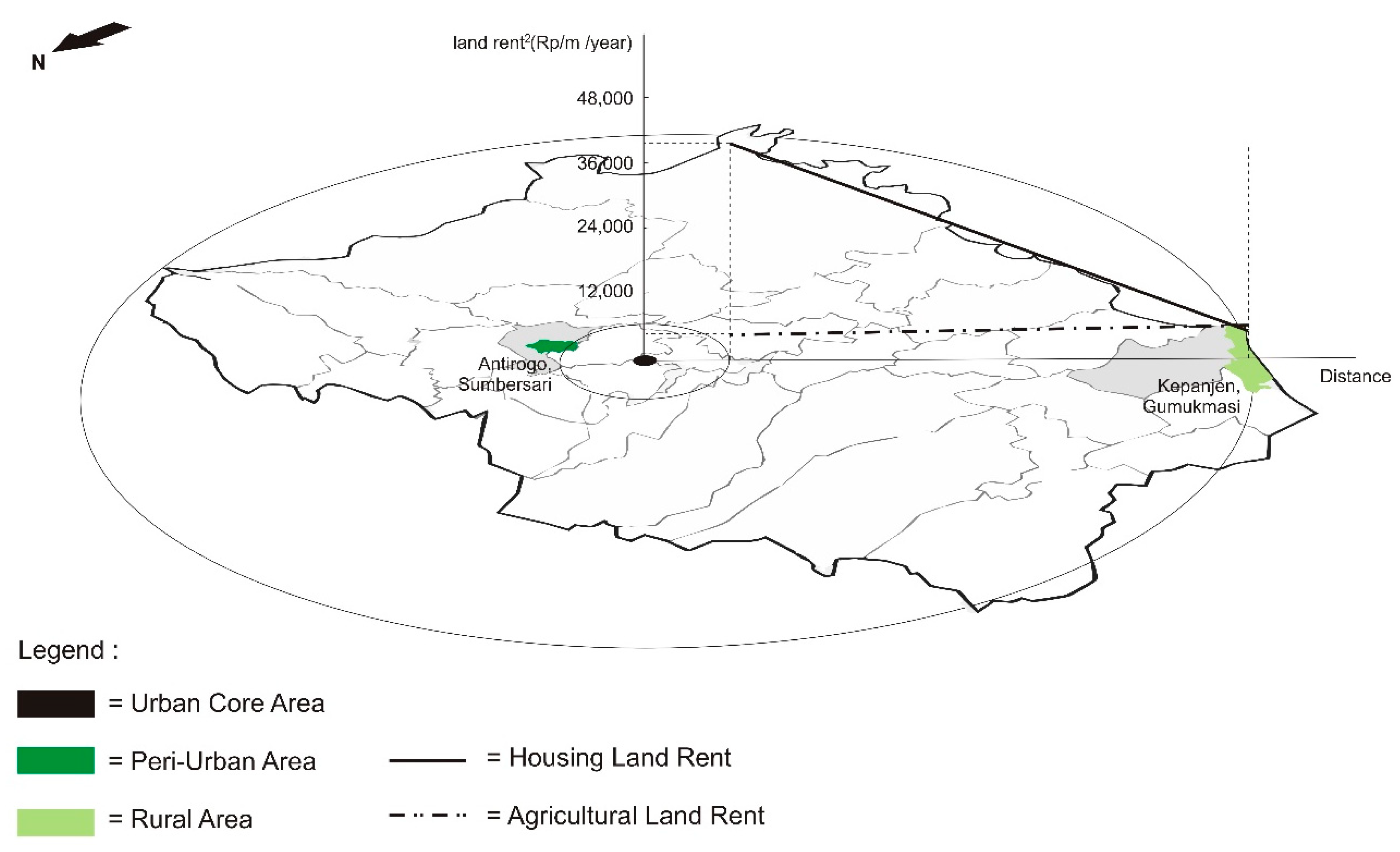
| Agriculture | Rp/m2/year | 6047 | 1600 | 19,504 | 4447 | −416 | 10,975 | 4997 |
| Housing | Rp/m2/year | 5059 | 278 | 14,908 | 39,954 | 7917 | 142,188 | 22,312 |
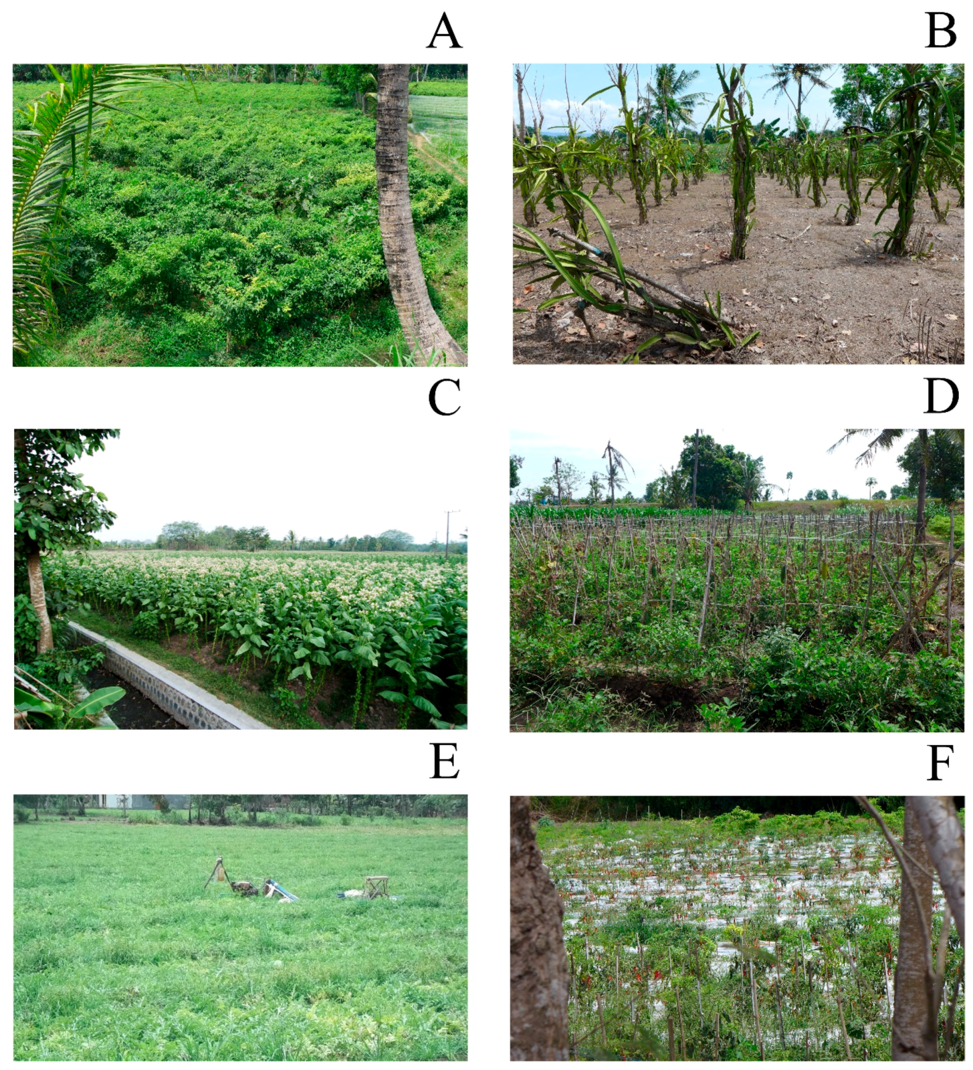
| Location | Cropping Pattern | Number of Farmers | Cropping Season (Rp/m2) | Yearly Average (Rp/m2) | ||
|---|---|---|---|---|---|---|
| 1st | 2nd | 3rd | ||||
| Rural | paddy, paddy, paddy | 7 | 2049 | 1825 | 1649 | 5477 |
| paddy, paddy, maize | 22 | 1786 | 1711 | 1442 | 4893 | |
| paddy, maize, maize | 5 | 2428 | 2068 | 1912 | 6336 | |
| no crop, paddy, paddy | 1 | 0 | 1521 | 1455 | 2907 | |
| no crop, paddy, maize | 2 | 0 | 1585 | 566 | 2111 | |
| paddy, maize, chili | 4 | 1434 | 1196 | 715 | 3303 | |
| paddy, maize, bitter melon | 2 | 2164 | 1637 | 7273 | 10,988 | |
| paddy, bitter melon, bitter melon | 2 | 3288 | 4438 | 4438 | 12,072 | |
| no crop, paddy, chili | 3 | 0 | 2932 | 2704 | 5603 | |
| paddy, chili, chili | 1 | 1024 | 332 | 332 | 1600 | |
| paddy, bitter melon, chili | 1 | 2445 | 6723 | 10,399 | 19,503 | |
| Peri-urban | paddy, paddy, maize | 30 | 1421 | 1590 | 706 | 2738 |
| paddy, paddy, tobacco | 20 | 1106 | 1336 | 4694 | 6777 | |
| Land Origin | Economic Value (Rp/m2/Year) | ||
|---|---|---|---|
| Mean | Minimum | Maximum | |
| Converted agricultural land | 7917 | 7917 | 42,230 |
| Housing | 45,063 | 45,063 | 142,188 |
| Agricultural Land | Housing | ||
|---|---|---|---|
| Variables | Coefficients | Variables | Coefficients |
| Intercept | 8890.691 *** | Intercept | 4858.626 ns |
| L.area | −0.151 * | B.area | −108.330 ns |
| Irrigation | −0.338 ** | Room | 3206.109 ** |
| Market | −1.052 *** | Road | −0.166 ns |
| Road | −4.145 *** | Downtown | −8.975 *** |
| Tenure | 186.858 ns | Location | 83,696.221 *** |
| Crop | 1950.186 *** | ||
| Fertility | 987.133 * | ||
| Location | −0.151 * | ||
| R2 | 0.656 | R2 | 0.640 |
| F test | 21.648 *** | F test | 33.450 *** |
| Observation | 100 | Observation | 100 |
© 2018 by the authors. Licensee MDPI, Basel, Switzerland. This article is an open access article distributed under the terms and conditions of the Creative Commons Attribution (CC BY) license (http://creativecommons.org/licenses/by/4.0/).
Share and Cite
Rondhi, M.; Pratiwi, P.A.; Handini, V.T.; Sunartomo, A.F.; Budiman, S.A. Agricultural Land Conversion, Land Economic Value, and Sustainable Agriculture: A Case Study in East Java, Indonesia. Land 2018, 7, 148. https://0-doi-org.brum.beds.ac.uk/10.3390/land7040148
Rondhi M, Pratiwi PA, Handini VT, Sunartomo AF, Budiman SA. Agricultural Land Conversion, Land Economic Value, and Sustainable Agriculture: A Case Study in East Java, Indonesia. Land. 2018; 7(4):148. https://0-doi-org.brum.beds.ac.uk/10.3390/land7040148
Chicago/Turabian StyleRondhi, Mohammad, Pravitasari Anjar Pratiwi, Vivi Trisna Handini, Aryo Fajar Sunartomo, and Subhan Arif Budiman. 2018. "Agricultural Land Conversion, Land Economic Value, and Sustainable Agriculture: A Case Study in East Java, Indonesia" Land 7, no. 4: 148. https://0-doi-org.brum.beds.ac.uk/10.3390/land7040148