Land of Plenty, Land of Misery: Synergetic Resource Grabbing in Mozambique

International Institute of Social Studies, Erasmus University Rotterdam, 2518 AX The Hague, The Netherlands
Land 2019, 8(8), 113; https://0-doi-org.brum.beds.ac.uk/10.3390/land8080113
Submission received: 2 May 2019
/
Revised: 14 July 2019
/
Accepted: 18 July 2019
/
Published: 24 July 2019
(This article belongs to the Special Issue The Politics of Natural Resources in the Era of Climate Change and Populism)
Abstract
:Global climate change policy enforcement has become the new driving force of resource grabbing in the context of the “scramble of resources” in Africa. Nevertheless, the environmental crisis should not be seen as an isolated phenomenon amid contemporary capitalism. On the contrary, a very distinct feature of the current wave of land grabs is the convergence of multiple crises, including food, energy/fuel, environmental, and financial. The Southern Mozambique District, Massingir, is an area with high potential regarding water sources and biodiversity. It recently became a host of a biofuel project, and also a huge block of land is being transformed into a conservation/tourism area; answering to many issues within capitalism’s crisis, this area is an evidence of how synergetic resource grabbing can arise as a response to the convergence of multiple crises. Therefore, by analyzing the emerging politics of natural resources in Massingir District and the dynamics regarding the land-use change, changes in property relations, it is possible to understand how rural livelihoods are shaped. Risks related to food security and sovereignty, loss of control and access to resources, consistent narrowing down of the set of livelihood strategies, and inter-community conflicts over scarce resources are the main implications of such emerging climate-smart land politics.
1. Introduction
The Global South, specifically, the African continent, has been at the core of land grabbing in the last decades. Currently described as “the third wave of land alienation”, the period this paper focuses on, is characterized both with increasing shifts in land ownership and property relations and deepening the integration of the continent into world markets and depletion of natural resources [1]. By analyzing the broad processes driving the land rush in Africa, Asia, and Latin America, the following factors have been identified as drivers of land rush: the increase in demand of cheap food, biofuels, conservation areas, tourism, creation of special economic zones, and migration dynamics [2]. In this context, Borras, Franco, Gómez, Kay, and Spoor [3] broaden the parameter of empirical and theoretical inquiry regarding land grabs within the dynamics of global capitalism. The authors point out that there is more to the context of land grabs than just the food crisis, there are other inter-related contexts through which land grabbing occurs, such as energy, fuels (biofuels), and climate change crises.
Scholars state that the contemporary land grab presents both continuities and changes from past waves of enclosures [1,4]. Past waves of enclosures also answered to the crisis of accumulation; nevertheless, contemporary land grabbing is said to be the capturing of control of blocks of land and other natural resources, specifically, involving large-scale capital, which shifts resource use orientation into extractive character, as a response to the convergence of food, energy and financial crises, and to the current climate change mitigation and adaptation imperatives [3]. So, a relatively new driving force of resource grabbing has entered the “scramble of resources” in Africa as a response to climate change concerns and policies, particularly, mitigation and adaptation policies. Among the most vulnerable countries in the world regarding climate change, Mozambique might be looked at as a potential solution for the environmental crisis due to its biodiversity, ecosystems, and ‘marginal’ lands. Nevertheless, past and current enclosures in specific regions of Mozambique have been driven mostly by the capital’s willingness to pursue natural resources, such as mineral resources and land for agricultural purposes.
Massingir District fits the profile of a block of land that constitutes the solution to tentatively overcome capitalism’s convergence of multiple crises as it is highly endowed by strategic natural resources. In an area that has a high potential in water sources (including a dam that aims to irrigate agricultural projects), the dynamics created between the implementation of a biofuel project and the transformation of a huge block of land into a conservation area with very ambitious goals of tourism development show competing and transversal trends of resource grabbing. However, there is a clear tendency of creation of synergies among the land-based projects being implemented, which is supported by the grabbing of resources such as water, land and biodiversity, in other words, synergetic resource grabbing is verified. So, exploring the new dynamics of the politics of natural resources, including land, water, and biodiversity, brings us to the main objective of the paper, that is, to identify and explore, through the experience of Massingir District, the dynamics regarding land-use change and changes in property relations. For that matter, the main research question that guides the structure and logic of the paper is: how does the synergetic resource grabbing, in a context of convergence of multiple crises, shape rural livelihoods in Massingir District?
By looking at the bulk of the land grab debates and literature through time, a common denominator is found, the displacement of people, intensification of inequalities, conflicts, social injustice, and an overall deterioration of rural livelihoods [1,2,3,5,6,7]. Nevertheless, the need of rethinking critical agrarian studies in the era of climate change seems to be one of the main drivers of research in the current juncture as the need to make sense of changing dynamics of access and control of natural resources conditioned by climate politics are depicted on the ground [5,8,9,10,11]. Because a very distinct feature of what is driving the current wave of land grabs in Massingir District is the convergence of multiple crises, including food, energy/fuel, environment, and financial [2], an inter-sector led analysis is needed for further understanding the inter-related dynamics and cross-interests of land grabbing trends and how it shapes the power relations regarding access and control of resources and, ultimately, rural livelihoods.
Conservation, development projects, and land deals in Massingir District imply displacement and resettlement of rural households to accommodate “more efficient” and “greener” projects. This means that different groups of peasants and pastoralists are displaced and are going through a continuous process of expropriation, including land, water, and forest resources, resulting in an unjust process of transformation of their livelihoods. To analyze and engage in this discussion, the author adopts a political economy lens, specifically with an agrarian political economy theoretical framework with regards to the conceptualization, process, and politics of land grabbing and dispossession, as well as its implications to rural livelihoods. The paper has also engaged with Bernstein’s four key questions [12] as the main tool/guide to analyzing the case of Massingir District: (i) Who owns what; (ii) Who does what; (iii) Who gets what; (iv) What do they do with it. These four questions put forward by Bernstein were built from a materialist historical perspective initiated by Marxist agrarian classics, which allows to carefully analyze how means of production are (re)distributed, depict what the dynamics of social relations and reproduction are, and what is the role of power relations. Overall, the study reveals how the systematic (re)concentration of resources, which is answering directly to the convergence of multiple crises, is embedded in an unfair process of rural transformation by creating new and synergetic vehicles of accumulation and consistently narrowing down the set of rural livelihood strategies.
2. Study Area and Methods
The Massingir District is located in the north-west of the province of Gaza, Southern region of Mozambique, and it is bordered to the West by the Republic of South Africa. The surface of the district is 5698 km2, and its population is estimated at around 33 thousand inhabitants [13]. According to a Government report, Massingir District has a great potential for tourism and ecology, yet to be explored, with 1500 km2 of Limpopo National Park (LNP) integrated into the Limpopo Transfrontier Conservation Area [13].
Around 60% of the population is put in the category of “peasant”, and the dominant activity among them is cattle raising. The district has about 4000 farms with an average area of 1.9 hectares, with about 92% of food crops, predominantly rain-fed [13,14]. Its endowment regarding infrastructures (including connecting and main roads and a Dam being rehabilitated), water sources, biodiversity, geographic location, and unprecedented claims of the existence of “marginal” land makes this region a pretty strategic target for contemporary global capitalism.
So, this study area allows to conduct an inter-sector led analysis, depict inter-related dynamics of land grabbing, and identify the determining character of power relations regarding access and control of resources. Therefore, fieldwork was conducted in December 2018 and January 2019, where the author collected primary data using a combination of methods: (i) unstructured (open) and semi-structured interviews and (ii) non-participant observation. Additionally, document analysis was used as a complement to primary data.
In total, twenty-five interviews were selected to analyze the case of Massingir District, including heads of rural households, Limpopo National Park (LNP) representatives, Government extensionists, and grass-roots social movements representatives, following a purpose sampling process of selection of interviewees. Additionally, five interviews were conducted in the capital city, where NGOs, academics, and social movements that work with land and rural issues are based. In Massingir District, the interviews were conducted with the following: (i) fourteen rural households; (ii) two grass-roots social movement representatives that were directly involved in the displacement and resettlement process; (iii) LNP administrative representatives (the administrator of the park and the resettlement officer); (iv) two local Government officials that provide agricultural extension services directly to the affected rural households.
In Maputo, two members of the National Peasant Union (UNAC) and three academics that had been studying that particular case were interviewed. All of the interviews aimed to understand the context, process, and implication of the process of land acquisition and re-allocation. The interviews conducted with rural households aimed to understand how this wave of resource grabbing did (including land, water, and other forest resources) shape their livelihoods, implicated in their income and overall well-being. They were also asked to do a description and comparison between their subsistence and survival strategies before and after the wave of resource grabbing.
Non-participant observation included field visits to the households living inside the LNP, to the households living in the resettlement areas outside the park, and to the buffering zone guided by the rural households themselves, to get the sense of what living conditions and subsistence strategies these different groups of people are engaged with.
To process the qualitative primary data collected, the transcription of interviews and field notes was conducted to allow the use of process tracing as the main tool to analyze the body of data gathered [15]. The main objective of this exercise was to identify causality and depict links between the inter-related processes and outcomes. Parallelly, to complement the qualitative data analysis, document analysis was conducted. Governmental and Non-Governmental documents, evaluations regarding national conservation strategy and, particularly, Massingir District’s agrarian policy, rural and tourism National Development Strategies, and other relevant documents were gathered, thoroughly analyzed, and crossed together with the empirical findings. By cross-analyzing the empirical data with the document analysis outcomes, the gathered data are systematized and synthesized into Table 1 and Table 2.
3. Massingir District: Biodiversity, Water Sources, and “Marginal” Land
3.1. Water Sources: Massingir Dam, Rio Dos Elefantes (Elephant River), and Displacement
The potentiality regarding water sources in Massingir District is quite noticeable. The main rivers that cross the district are the Elephants River and Mazimulhpe River, both of permanent flow. There are also eight rivers and 10 lagoons across the district [13]. However, only approximately 6% of the population has access to piped water at home. Around 42% of the population access water through the river or lakes. According to the latest official records, around 7% has access to electricity [10].
The Massingir Dam is located in the Elephants River (right next to the Massingir minor town—see a map of Massingir District in Figure 1). The construction of the Dam started in 1972, before the independence, and its official opening was in 1977 [13]. The construction of the Dam implied the displacement of a community that was established in the surroundings of the river, mainly cattle raising and farming. In 1977, they were resettled into a new area called Mavodze (See Figure 1).
This Dam was designed with multiple objectives, including irrigation and hydroelectric power generation. It has the potential to irrigate 90,000 hectares with a highlight to 30,000 hectares of the biggest irrigation system in Mozambique in Chókwé (a district downstream) [16]. After an accident in 2008, the Dam needed to be urgently rehabilitated. Until recent days, according to the official website of the Ministry of Economy and Finance [17], the Government has been able to get enough financing to cover the costs of the rehabilitation through the African Development Bank (total of USD 33 million). According to the Minister of Economy and Finance, the rehabilitation project financed by the African Development Bank aims mainly to boost agricultural production and productivity and production of electric energy. Additionally, the infrastructure is also expected to contribute to reducing the impact of climate change by improving the management and availability of water resources [18].
3.2. Biodiversity: Conservation, The Limpopo National Park, and the Second Wave of Displacement: Poor People out, Tourists in!
The West side of the Massingir District is bordered by South African Kruger National Park (KNP), which is the largest game reserve in South Africa, covering approximately 20,000 Km2. Both the Mozambican and the Zimbabwean borders are part of KNP’s animal migratory routes. According to the Administrator, created in 2001, the Limpopo National Park (LNP) (see the dark green area of the map—Figure 1) aims to extend ecosystems and promote conservation of biological and non-biological resources for the well-being of the community, whether local or of the entire Mozambican community or humankind. The Park has an area of 10 thousand km2 covering Massingir District (2100 km2), Chicualacuala District (6400 km2), and Mabalane District (1500 km2), but it is also part of the Limpopo Transboundary Conservation Area established in December 2002 through a Treaty between the Republic of Mozambique, the Republic of South Africa, and the Republic of Zimbabwe, covering an area of 35,000 square kilometers [13].
The Agence Française de Développement (AFD) evaluation document [14] states that the exceeding fauna in KNP, and, the almost intact flora formations in LNP combined with the decimated fauna during Mozambique’s civil war, all together contributed to the creation of the transfrontier park. The treaty includes activities, such as (i) development of tourism facilities, such as ecotourism, adventure, water sports, and culture; (ii) removal of fences between the border of KNP and LNP and relocation of 5000 animals from KNP to LNP; (iii) construction of a barrier fence to separate the wildlife core zone from the community buffer zone; (iv) reallocation of 1200 families and implementation of various community programs following World Bank’s Operational Policy for Involuntary Resettlement; amongst others [19]. This resettlement is considered one of the most protracted conservation-related displacements unfolding within Southern Africa [20].
One of the communities to be displaced is in the Mavodze area (the Mavodze community), the same families that were previously resettled more than 30 years ago to give space to the Massingir Dam’s construction. In other words, the same group of people is going through a second wave of expropriation of land and resources. So far, only two communities from inside the park are already resettled, and five communities (including Mavodze) remain inside the conservation area where wildlife is being promoted. All of these activities, including the creation of the Park’s buffer zone, is supported by foreign donors.
Support for the development of LNP began in 2001 as part of an integrated regional and multi-donor approach: EUR 6.1 million from the Kreditanstalf für Wiederaufbrau (KfW) to finance the resettlements and EUR 11 million from AFD. The World Bank was involved in an earlier phase, with aid directed to institutional support of the LNP through the creation of the national institution of conservation – ANAC (Administração Nacional de Áreas de Conservação). The AFD’s support had three main goals [14]: (i) restore and preserve the LNP’s biodiversity (EUR 1.7 million): implementation of tourism facilities, biodiversity protection, ecological research, and monitoring and ecological management programs; (ii) improve the livelihoods and standard of living of the inhabitants of the LNP buffer zone (EUR 8 million); (iii) strengthening the administrative capacity of LNP (EUR 0.7 million).
Two main points should be underlined within the strategies of the international donors and the Park itself: the promotion of tourism development and the buffer zones. According to the official plan of LNP [21], the main goal regarding tourism development in the park is “to make them [tourists] come, keep them in, and keep them busy”. The first set of activities are related to the creation of strategic entry points and roads to give access to the Park to let the tourists come. Afterward, the creation of camping sites and accommodation facilities throughout the Park is done. The accommodation facilities are going to be held offering concession to private investors of 8000 to 10,000 Ha of 3, 4, or 5 stars. Activities to “keep tourists busy” include safaris and other land-related activities and fishing (through concessions in Massingir Dam) and other water-related activities [21]. So far, the number of tourists has been oscillating from 20,000 to 25,000 a year [14].
On the other hand, to keep the biodiversity, fauna, flora, and ecosystems up to tourism sector demands, the protecting function of the buffer zone is particularly determinant. The buffer zone surrounds the whole area of LNP, and it is represented in the map by the lighter green color (see Figure 1). According to the evaluation made by AFD consultants [14], more than 20,000 people are established in the buffering zone. The aid from AFD aims to implement irrigation systems, adoption of climate-smart agriculture for the production of food, and a mechanism of micro-credit for increasing the income of the rural households.
3.3. “Marginal” Land: Procana’s Biofuel Production and Land Conflicts
The Mozambican Government has been actively aiming the promotion of production of biofuel in the country since the approval of the bulk of legislation and regulations regarding biofuel in Mozambique, which is led by the main policy “Estratégia e Política Nacional de Biocombustíveis”. An official publication of the Ministry of Energy [22] states that “several activities are underway to materialize large biofuel production projects and bioethanol, respectively, especially the project to build a biofuel plant in the Massingir District in Gaza Province - called the PROCANA Project”.
Procana, a London based company that acquired 30,000 hectares close to the dam (in the red area closest to the Massingir minor town – see Figure 1), was approved in 2009 as an investment project aiming to accommodate a sugarcane/ethanol plantation, create 7000 direct jobs, and engage in a scheme of sugarcane outgrowers. All of this is following Mozambique’s Governmental strategy on biofuel intending to boost biofuel production in the country. Several official Government documents state that the dam is expected to meet the water demand from the potential biofuel project implementation. The 30,000 hectares, expected to be irrigated by the dam, was appointed to be in the exact area, initially assigned to resettle the communities living inside the park (see a red area of the map bordering Massingir minor town), consequently, conflicts arose because the land allocated to Procana wasn’t marginal after all. It was prime agricultural land for food production, strategically located with water sources (Massingir Dam and Rio dos Elefantes) and infrastructures (national road and highways) [6].
After two years, the company lost its right to use the land, and among several speculations related to delays in the implementation of the project and global financial crisis of 2007/8, the delay in the rehabilitation of the dam might have contributed. So far, the Dam hasn’t been fully rehabilitated, consequently, threatening the availability of water to feed the ethanol. Procana dissolved in 2011; however, a new and bigger investor showed interest (volume-wise): Massingir Agro-Industrial (MAI), a partnership between a South-African company (TBS) and a national investor (Mozambican firm SIA). But, this also resulted in no success.
Although a lot of companies showed interest in investing in that area and, particularly, in ethanol project, such as the investment of USD15 billion from Kuwait [23], so far, the Government published a statement approving the dissolution of the MAI’s DUAT (Direito de Uso e Aproveitamento da Terra—Right of Use of the Land), claiming that the company did not fulfill the proposed business plan. However, with the systematic postponement of the resettlements in that area and the current readiness of the Dam to be rehabilitated, the easier it would be to accommodate potential investors in the ethanol project.
Overall, in the past decades, Massingir District had a lot of different purpose claims to major blocks of land, competing or not. This calls for a deeper understanding regarding the dynamics of land politics of the area, to potentially identify the patterns and motives behind land expropriation and resource grabbing, as well as its implications.
4. Analyzing the Land Question in Massingir District: Multiple Resource Grabbing and Land Politics
4.1. Contextualizing Land Grabbing, Conservation, and Resource Grabbing
The concepts of land expropriation and dispossession have been at the crux of agrarian political economy since Marx’s inputs regarding expropriation of land and primitive accumulation [24]. Many of the recent theoretical progress in land grabs literature have been made using either Marx’s primitive accumulation and/or the more recent accumulation by dispossession by Harvey [25], as analytical tools. Nevertheless, it has been more than a decade since the analytical term “land grabbing” or “land grabs” is used to characterize the socially unjust and economically unequal processes through which enclosures of land occurs in the global south, especially after the food prices peak in 2008–2009 [2,3,4,5,6,7]. A very distinct feature present in both the land grabbing debate and land grabbing/conservation debate is the heavy presence of financialization (see Table 1). As part of the land rush, the concept of financialization comes from the growing interest of finance, which include sovereign and pension funds, investment banks, development finance institutions, and so on, in food production and agri-food chains [26].
In the context of land grabbing processes related to conservation areas, two main losses are at the core of this specific dispossession process: the land of the people and the restriction of the resources that people have access to. Studies show how the restriction of local resources is justified by degradation narratives; however, the ecotourism sector gets an opportunity to accumulate [27]. In the African context, particularly, in the case of Tanzania, where increasing areas have been designated to conservation of wildlife, marine, and coastal areas, there is a clear tendency of increasing processes of accumulation by dispossession that use the narratives of degradation and the implementation of a so-called “community-based conservation” to support the transfer of land from peasants or rural population to more “powerful” economic actors seeking rents and profits [27,28]. Additionally, specific cases of ecotourism through land appropriation show how mainstream environmentalities can be used to facilitate processes of re-territorialization of areas, such as the separation of wildlife habitats and human interaction, that ultimately undermine land rights of rural households, such as peasants and pastoralists communities [29].
In the context of conservation and land grabbing, and also for the matter of this paper, it is important to clarify the distinction between “land grabbing” and “resource grabbing”. Land grabbing refers to the appropriation of the land and all of the resources that are implanted in it; however, the use of “resource grabbing” throughout the paper clearly refers to resources that are located beyond the block of land that was specifically appropriated; it refers to resources (tangible and intangible) that were once accessed before the block of land was appropriated. Some examples would be all of the goods, rivers, lakes, forests, biodiversity in the surrounding the block of land grabbed, or the easy access to higher quality water or forest resources, or even access to spiritual/traditional sites, and so on.
On the other hand, conservation might go hand in hand with other sectors, such as mining, as it happened in Southeast Madagascar; although these constitute distinct types of land acquisition, there might be linkages and interdependencies between them [30]. In the case of Southeast Madagascar, mining company’s engagement with conservation, such as Rio Tinto/QIT Madagascar Minerals setting aside protected areas to preserve biodiversity, might be considered an interdependent mode of accessing and acquiring land and, of course, part of their legitimization strategy [30].
Nevertheless, the paper seeks to look beyond the dual forces of dispossession. It aims to understand the convergence of forces of dispossession in a specific region, looking at the patterns of land-use change and property relations. Regarding that matter, Borras and Franco [4] took one step further into the understanding of land grabs. Regarding changes in land-use, they identified four main typologies that potentially capture the diversity and complexity of land-use change: (i) food to food; (ii) food to biofuels; (iii) non-food to food; (iv) non-food to biofuels. Not all land grabs entail the same implications for changes in land-use as the traditional trans-national commercial land deals do, so they suggest the need for further mapping the nature and direction of land-use change as well as take a disaggregated look at the rural poor in terms of class, gender, and other dimensions.
Regarding the changes in land property relations, Borras and Franco discuss the extent to which access and control over land are shaped among the dominant social classes and groups (landlords, capitalists, traditional village chiefs), whether if it is considered private property de jure or de facto [4]. Places like Mozambique, where the land is owned by the State, the outcome of these land deals cannot fully be considered “dispossession”, but more in the dimension of land re-allocation because resettlement of the displaced population is required by Law.
So, the authors came up with four main broad patterns in the nature and direction of land property relations change: (i) Type A – redistribution of land from private landed classes or from the state to (near) landless working poor – redistributive land reform; (ii) Type B – distribution of land from private landed classes to (near) landless working poor, but the private entity if fully compensated by the State; (iii) Type C – Non-(re)distribution portrays the maintenance of the status quo, characterized with land-based inequity and exclusion; (iv) Type D – (re)concentration happens when transfer of land occurs, but the access and control over land is further concentrated in dominant social classes, involving full ownership or not.
4.2. Massingir District’s Changes in Land-Use and Property Relations: Borras and Franco’s Typology
Looking specifically at African history, three waves of land alienation in Africa were identified [1]. The authors state that the first wave set the stage for the classic scramble in the late nineteenth century by settler-colonial expansion. The second wave took off in the period of structural adjustments parallel to the wave of privatization of property under the wing of World Bank advice. This process of liberalization shaped agrarian reforms in Africa to seek commodity markets with deeper integration into the world food system. Currently, with the intensification of neoliberalism, the third wave of land alienation arises with a wider scramble for mineral energy and biogenetic resources.
Mozambique is currently in the top 10 countries in the world regarding the so-called “large-scale land acquisitions”, and the 5th in Africa with approximately 3.9 million hectares acquired by transnational deals (Land Matrix website, 10th April of 2019). The third wave of land alienation implies land ad resource grabbing, shifting land control, and changing property relations, which consequently results in “expanded marginalization of rural communities and expulsion from the countryside, without resolving chronic problems of food insecurity, unemployment, low agricultural productivity, and poverty” [1] (p. 4).
In the case of Massingir District, the high amount of land alienated, whether it is purportedly for biofuel production or conservation, clearly implied changes in land-use and property relations, specifically having into account the specificities of official property land rights in the context of Mozambique. According to the Land Law 19/97, the land is owned by the State and cannot be, in any way, privately owned. In order to accommodate land-based investments, the investor should apply to the right of use of the land (DUAT – Direito de Uso e Aproveitamento da Terra) which can be: (i) temporary DUAT: the investor has the right to use the land and is given two years period to implement the project; after this, the investor is able to get the (ii) permanent DUAT: if the project is implemented accordingly, the investor has the right to use the land up to 50 years renewable over time. Both imply that in the case there are local inhabitants established in that area, they should be resettled and compensated certifying the maintenance or improvement of their livelihoods.
Going back to Borras and Franco’s typology [4], changes in land-use in Massingir District follow multiple patterns in the same block of land. The first pattern is characterized by the ‘food to biofuel’ typology stated by the authors, as 30,000 hectares of grazing and farming land to produce food to local inhabitants was pointed out to ethanol production in the region of Banga (see Figure 1). Despite the successive failures of potential investors, the land is currently considered a “reserve” land for the implementation of the project soon.
The second main pattern is the transformation of land used to produce food to an environmentally friendly land, which brings us to another pattern of land-use change, “Food to biodiversity” that can be unfolded in two different ways: (i) directly transforming land used to produce food to a conservation land with eco-tourist investments (namely the Limpopo National Park) and (ii) indirectly transforming land used to produce food to land used to protect biodiversity, in the case of the surrounding areas of the park (the so-called “buffer zone”). The land in the buffer zone is still aiming to produce food, but with environmentally friendly techniques imposed by the park and its donors to protect and reproduce the biodiversity and ecosystems of the park. This pattern of land-use change is still relevant in the commercial sphere because it aims ultimately to reinforce accumulation through the tourism sector to be developed in the park.
Regarding the second sphere of the typology, namely changes in property relations, we see that loss of control and access to land by local inhabitants (peasants, pastoralists, and rural households) is verified. To analyze the changes in property relations is important to understand the four main groups of people that were implicated in these processes of land grabbing: (i) rural households previously living inside the park that are already resettled; (ii) rural households who received the resettled communities in their land and shared all of the facilities (“host communities”); (iii) rural households that were appointed to be resettled but are still living inside the park; (iv) rural households living in the buffer zone. Groups 1, 2, and 3 were in some way displaced and lost control over their means of production and subsistence. Group 4 is a typical example of not being dispossessed nor displaced but still losing control over their land since the decision on how and what to produce, and what resources to use are not in their power. Overall, the District depicts clear patterns of (re)concentration of land because the access and control over land are further concentrated in dominant social classes, involving full ownership or not.
From the Massingir District experience, it is clear that land is at the core of the ability to overcome several capitalistic crises. The contemporary context of capitalism, calls for land-based solutions that can simultaneously answer to many different demands from the current conjuncture, particularly, climate change-related regulations and enforcements following the accomplishment of the twin objectives [3]: efficiency (profit) and environmentally friendly, in the midst of what they called climate-smart land politics.
5. Climate-Smart Land Politics in Massingir District and the Implications to Rural Livelihoods
5.1. The Convergence of Multiple Crises and Synergetic Resource Grabbing
Massingir District has become a target of the convergence of multiple crises. The emergence of a biofuel project and the transformation of a big block of land into conservation very ambitious regarding the development of tourism, are both supported by the district’s high potential in water sources. Water control is currently shifting hands and will highly increase its concentration with the full implementation of the biofuel project, full implementation of the irrigation systems in the buffering zone of the park, and the full implementation of tourism activities that include rivers and the dam itself. In the context of the current wave of land grabs, some authors underline the concentration of control, ownership, and use of water resources in Africa, a continent that utilizes only 3.8% of its water resources, and it is verified that the land that is being grabbed is high in water endowment [1].
Looking at the “Current/new use of land” column, it is possible to understand how interconnected these projects are and how they can gain from each other’s implementation. Although it might seem like different actors competing over the same block of land, they manage to establish a synergetic grab of resources not only through expropriation but also through concentration of control of resources. This set of resources, including land, water, and biodiversity, and other resources maximize and answer to all of the actors’ interests, whether it is profit or climate change.
On the other hand, although the twin objectives are present in all of the projects, the environmentally friendly factor is quite determinant and most definitely a common denominator of this capitalistic patterns of land and resource grabbing and control. That said, there has been a quite clear tendency of land-based projects to be “climate-smart”, such as in Massingir District, in other words, the tendency to ultimately follow climate-smart land politics.
5.2. Massingir District’s Climate-Smart Land Politics and Implications for Rural Livelihoods
Table 1 shows a summary of the trends of land/resource grabbing happening in Massingir District. Environmental causes are the common denominator. In the context of land grabbing debates related to the environmental crises, it is important to engage in the discussion of the emerging appropriation of nature, namely “green grabbing”, known as the appropriation of land and resources for environmental ends [31], which goes in line with the trends verified in Massingir District. The implications of this type of resource grabbing involve the prevention of livelihood practice and resource uses and restructuring of labor relations [31].
Although “green grabbing” and its most known implications go in line with what has been happening in Massingir District, it is important to reflect within a much more complex lens, such as evaluating the other types of grabbing going on and the ways they synergistically inter-relate to one another. This case portrays resource grabbing both for the profit and environmental ends, and through the “efficiency” and “environmentally friendly” goals, it is relevant to look at the logic behind the re-allocation of land and other resources. The neoliberal logic of distribution and allocation of resources, based on the most “efficient” and/or “competitive” economic agent, currently extends through the most environmentally friendly use of resources and with the most expansion of carbon metrics to nature conservation and climate change politics [3].
Overall, land-based climate change policies incorporate the twin objective of combating inefficient and destructive use and users of natural resources in the countryside, especially in the Global South. Land control is said to be one of the common denominators of these policies in the countryside, whether it is from biofuel production, implementation of conservation projects and REDD+, (Reducing Emissions from Deforestation and forest Degradation) or even through Climate-Smart Agriculture [3]. These combined processes result in what is called “climate-smart land politics”, which is “a predatory type of land politics that serves the neoliberal campaign against what it assumes and perceives to be as inefficient and destructive use of scarce natural resources. Simply put, climate-smart land politics is neoliberal land politics sensitized to the recent corporate rediscovery of agriculture and market-based climate change mitigation/adaptation initiatives.” [3] (p. 1319).
So, Massingir District’s patterns of land concentration are quite an example of how a climate-smart land would look like in the context of convergence of multiple crises and responses to them. It is continuously going through a transformation, mostly from land used to produce food to subsistence to climate-smart projects and investments. All of this process is regardless of the opinion and consent of the population that has to change their ways of living to accommodate such interests. In this context, the leader of Mavodze stated:
“We lived a good life from 1977 to 2001. We even had enough grazing land to our cattle. But in 2001, some Government representatives came and informed us that this place, which was a hunting concession before, will be turned into a National Park. We did not agree with that. We are used to living here. The other community that lived inside the park was already resettled, and they are in a very bad situation now; they received compensation, but it is not enough!” [32]
These are the words of a Leader that would rather live inside the park, constantly confronting wildlife, than being displaced somewhere where resources are scarce. So, little by little, resources and agricultural land available in this particular area is becoming more and more scarce for local inhabitants that rely on it as their main mean of subsistence.
To understand how rural populations’ livelihoods are shaped by these predatory processes, one should understand how the set of livelihoods looked like and in which way they were transformed. According to the primary data collected among rural households, in Massingir District, most of the households engage in the following activities: (i) cattle raising; (ii) farming; (iii) hunting; (iv) fishing. Additionally, rural households follow what Bryceson called ‘rural income diversification’ referring to the tendency of rural dwellers to expand their income sources and not just rely on their farm work [33]. Additionally, in the context of convergence of multiple crises, contemporary capitalism has been resulting in forcing ‘working people’ [34] or the ‘classes of labor’ [12] to combine various strategies to construct and defend their livelihoods to survive [10]. So, it is very common that these rural households engage in other activities, such as wage employment (in urban areas or even intracommunity wage employment) to meet their subsistence need and even reproduction.
Apart from selling labor, empirical data showed that most of them engage in commercial activities such as (i) brew and sell alcoholic beverages; (ii) producing and selling charcoal; (iii) offer traditional health services; etc. Of course, the set of strategies adopted by each household will then be determined by the amount of land and labor available for that particular household throughout time. What then has happened to this dynamic set of livelihood strategies of Massingir District’s inhabitants when they face this emergence of climate-smart prioritization regarding the allocation of land and other resources? When asked about this matter, a peasant/pastoralist responded in the following way:
“In the past, we were able to hunt, we could eat meat, but now we no longer have that right of hunting. In the past, when it was a dry season, we could hunt, sell it, so that we could afford to pay some expenses for the children in the schools, for instance. My wife is a healer. Last week, we went to the bush in search of medicinal plants, but the Park inspectors caught us and told us to go back, they said we could not take the medicinal plants. Even firewood has a limit” [33].
To understand this further, it is necessary to have in mind all of the processes of dispossession and of grabbing control over resources. To analyze this matter, we have looked at the experience of four of the many communities that suffer some kind of dispossession or lost control of their resources:
The Mavodze community, although did not go through displacement, is suffering from the restriction of resources that they had access to before, plus, they are now facing risks for living amid wildlife promotion. For Macavene, the community was dispossessed and lost access to forest resources; but they were re-allocated to another land where they have to share resources that belonged to other people, the Chinhangane community. Consequently, because of the scarcity of the resources left to both communities, conflicts arose. When asked about the well-being of the recently resettled community, its leader responded:
“Things changed. First, they put us in an area that belongs to other people, other leaderships. We no longer have spaces to cut wood because when we go to the bush, people say ‘no, this is my area, you cannot cut anything here’, so we feel limited. The same situation for areas to practice agriculture, they already have owners. Macavene [the area where they lived before the resettlement] felt good. I had rights, I had space to research until I get the things I needed out of the forest so that I could use it. Here, I no longer have that possibility because here everything has owners. Us, men, did not suffer in buying meat, when we had an appetite to eat meat, we would just go to the bush and catch a rabbit to feed our families, but here it does not happen anymore. Even fishing, fishing is no longer easy because the areas we were used to fishing already belong to LNP” [35].
Nevertheless, the host community - the community who received the resettled community in their land, namely Chinhangane community - counter-argument in the following way:
“When we negotiated with the park to receive the resettled, we understood that they would compensate us, but we did not get anything. Also, the plots given to the ‘comers’ was land from the residents of Chinhangane, and they were plots of the residents of Chinhangane. The community is revolted and want to recover the goods that they gave to the ‘comers’. Because they [residents of Chinhangane] gave their land to have some positive return, but since it is not happening, they are thinking of taking these goods back, everything they gave to the ‘comers’. Maybe it is a way to solve the problem…” [36].
On the other hand, the Buffering Zone Communities (BZC) were not dispossessed but are suffering from the restriction of resources that they had access to before and are going through an involuntary process of livelihood transformation.
Although all of them are going through the involuntary process of livelihood transformation, each group of rural livelihoods has been shaped differently. Nevertheless, all of them are now facing risks regarding the production of enough food and income for subsistence. As Table 2 shows, even communities that haven’t been directly displaced or dislocated (Banga and BZCs) are going through the same process of exponentially narrowing down the set of livelihood and subsistence strategies. Particularly, the communities being (or to be) resettled and the ones “hosting” their resettlements are left with scarce resources to share amongst them.
6. Conclusions
The design of climate-smart land or blocks of lands seems to be the current strategy of contemporary capitalism, and cases, such as Massingir District, where politics are driven by this twin factors, will become more common as climate change narratives predominate and its mitigation and adaptation policies are implemented. The dynamics and synergies created between the implementation of a biofuel project and the transformation of a huge block of land into a conservation area with very ambitious goals of tourism development show how synergetic resource grabbing can happen as a response to the convergence of multiple crises. The changes in land-use and property relations happened in a way that created synergies between the projects. A clear example of this is the way that the water sources are strategically expected to feed all of the projects of the blocks of land that are being grabbed: ethanol project, LNP/tourism, and the Buffering Zone.
By revisiting the typology of changes in land-use, as well as changes in property relations, through the experience of Massingir District, two main patterns of changes in land-use were identified: (i) food to biofuel (Procana/ethanol project) and (ii) food to biodiversity. The latter emerges as the 5th pattern of land-use change that fits current dynamics of capitalism and demand for land for environmental ends that end up being also for commercial ends with tourism (ecotourism or nature tourism) as the main vehicle of accumulation. Consequently, changes in property relations show a high tendency of (re)concentration of land control by a group of actors: private investors and the Government itself. By analyzing each of the four groups of rural households that were implicated in this process of land re-allocation, it becomes clear that all of them lost control of resources, even the ones that did not suffer displacement or direct expropriation, and these are the resettlement “host” communities and the communities living in the Buffering Zone of the park.
However, the fact that the common denominator of these processes of land-use change in Massingir District is the re-allocation of the land/resources and is claimed to be an environmentally friendly project, whether it is to produce fossil fuels substitutes or to protect biodiversity. These claims aim to answer directly to the current global narratives and enforcements related to the convergence of climate change, energy, and food crisis, but have adverse implication to local inhabitants. Taking a closer look at these processes of land-use change and property relations chronologically and complementing it with an in-depth analysis of current dynamics, it is possible to understand how cumulative effects of resource grabbing contribute to the scarcity of resources in rural societies. Consequently, precariousness, vulnerability, and conflicts emerge or are intensified as rural livelihoods are highly shaped.
Risks related to food security and sovereignty, loss of control and access to resources, and consistently narrowing down of the set of livelihood strategies and inter-community conflicts over scarce resources are the main rural livelihoods implications of such emerging climate-smart land politics. Overall, local inhabitants lost, not only, the means of production to produce food but also lost the control on how and what food to produce or eat and were ultimately left fighting over the crumbs of capital. Nevertheless, further research is relevant to understand what the role of rural inhabitants’ agency amid synergetic resource grabbing and scarcity is. Additionally, important issues regarding power relations have to be taken into account when depicting rural livelihoods changes and the willingness to resist. Some examples of these variables would be the role of local elites and grass-roots social movements.
Funding
This research received no external funding.
Acknowledgments
A special thanks to Jun Borras, Ruth Hall and Daniela Andrade for the support and comments. This paper was also presented and discussed at the Writeshop in Beijing and I would like to thank the participants and the organizers of the Writeshop held at College of Humanities and Development/China Agricultural University on 1-7 July 2019, co-organized by Journal of Peasant Studies, College of Humanities and Development/China Agricultural University (COHD/CAU), Institute for Poverty, Land and Agrarian Studies (PLAAS), Young African Researchers in Agriculture (YARA) and Future Agricultures (FAC). Also, very grateful for the three anonymous reviewers who provided constructive feedback to the paper. Last but not least, a very special thank you to Observatório do Meio Rural for the determinant support provided during fieldwork.
Conflicts of Interest
The author declares no conflict of interest.
References and Notes
- Moyo, S.; Jha, P.; Yeros, P. Reclaiming Africa: Scramble and Resistance in the 21st Century; Springer: Berlin/Heidelberg, Germany, 2019. [Google Scholar]
- Zoomers, A. Globalisation and the foreignisation of space: Seven processes driving the current global land grab. J. Peasant Stud. 2010, 37, 429–447. [Google Scholar]
- Borras, S.M., Jr.; Franco, J.C. The challenge of locating land-based climate change mitigation and adaptation politics within a social justice perspective: Towards an idea of agrarian climate justice. Third World Q. 2018, 39, 1308–1325. [Google Scholar]
- Borras, S.M., Jr.; Franco, J.C. Global land grabbing and trajectories of agrarian change: A preliminary analysis. J. Agrar. Chang. 2012, 12, 34–59. [Google Scholar]
- Hunsberger, C.; Corbera, E.; Borras, S.M., Jr.; de la Rosa, R.; Eang, V.; Franco, J.C.; Sokheng, H. Land-Based Climate Change Mitigation, Land Grabbing and Conflict: Understanding Intersections and Linkages, Exploring Actions for Change; MOSAIC Research Project: The Hague, Netherlands, 2017. [Google Scholar]
- Borras, S.M., Jr.; Fig, D.; Suárez, S.M. The politics of agrofuels and mega-land and water deals: Insights from the ProCana case, Mozambique. Rev. Afr. Political Econ. 2011, 38, 215–234. [Google Scholar]
- McMichael, P. The land grab and corporate food regime restructuring. J. Peasant Stud. 2012, 39, 681–701. [Google Scholar]
- Work, C. Intersections of Climate Change Mitigation Policies, Land Grabbing and Conflict in a Fragile State: Insights from Cambodia; MOSAIC Research Project: The Hague, Netherlands, 2015. [Google Scholar]
- Clapp, J.; Newell, P.; Brent, Z.W. The global political economy of climate change, agriculture and food systems. J. Peasant Stud. 2018, 45, 80–88. [Google Scholar]
- Borras, S.M., Jr.; Moreda, T.; Alonso-Fradejas, A.; Brent, Z.W. Converging social justice issues and movements: Implications for political actions and research. Third World Q. 2018, 39, 1227–1246. [Google Scholar]
- Tramel, S. Convergence as political strategy: Social justice movements, natural resources and climate change. Third World Q. 2018, 39, 1290–1307. [Google Scholar]
- Bernstein, H. Class Dynamics of Agrarian Change; Kumarian Press: Sterling, VA, USA, 2010; Volume 1. [Google Scholar]
- RM (República de Moçambique). Perfil do Distrito de Massingir Província de Gaza; Ministério da Administração Estatal: Maputo, Moçambique, 2014. [Google Scholar]
- Basin, F.; Quesne, G. Avaliação Ex Post escrita e filmada do projecto de desenvolvimento do Parque Nacional do Limpopo; Avaliação Solicitada Pela AFD. Ex Post No. 61; AFD: Paris, France, 2016. [Google Scholar]
- Bennett, A.; George, A.L. Case Studies and Theory Development in the Social Sciences; The MIT Press: Cambridge, MA, USA, 2005. [Google Scholar]
- Biodinamica. Projecto de uma Central Constituída por 3 Unidades de Geração de Energia Modulares e Linhas de Transporte Associadas. January 2017. Available online: https://biodinamica.co.mz/wp-content/uploads/2017/01/EPDA_Chokwe_Rev0_05Jan17.pdf (accessed on 22 July 2019).
- Ministério de Economia e Finanças. Available online: http://www.mef.gov.mz/index.php/destaques/53-acordo-entre-governo-e-o-bad-garante-o-funcionamento-pleno-da-barragem-de-massingir (accessed on 22 July 2019).
- RM (República de Moçambique). Notas De Intervenção De Sua Excelência o Ministro da Economia e Finanças, Adriano Afonso Maleiane; MEF: Maputo, Moçambique, 2018. [Google Scholar]
- Limpopo National Park. Available online: http://www.limpopopn.gov.mz/about.php?header=elephant (accessed on 22 July 2019).
- Lunstrum, E. Green grabs, land grabs and the spatiality of displacement: Eviction from Mozambique’s Limpopo National Park. Area 2016, 48, 142–152. [Google Scholar]
- Limpopo National Park. Plano Estratégico para a Comercialização do Turismo. Elaborado pela Peace Park Foundation; LNP: Maputo, Moçambique, 2011. [Google Scholar]
- Available online: https://energypedia.info/images/9/95/PT-Realizacoes_do_Sector_de_Energia_2005-2008-Ministerio_da_Energia.pdf (accessed on 22 July 2019).
- Macau Hub. Available online: https://macauhub.com.mo/pt/2015/05/28/kuwait-invests-us1-5-billion-in-agro-industrial-project-in-mozambique/ (accessed on 22 July 2019).
- Marx, K. Capital: A critical Analysis of Production; International Publishers Co.: London, UK, 1889. [Google Scholar]
- Harvey, D. The New Imperialism; Oxford University Press: Oxford, UK, 2003. [Google Scholar]
- Ouma, S. Situating global finance in the Land Rush Debate: A critical review. Geoforum 2014, 57, 162–166. [Google Scholar]
- Benjaminsen, T.A.; Bryceson, I. Conservation, green/blue grabbing and accumulation by dispossession in Tanzania. J. Peasant Stud. 2012, 39, 335–355. [Google Scholar]
- Gardner, B. Tourism and the politics of the global land grab in Tanzania: Markets, Appropriation and Recognition. J. Peasant Stud. 2012, 39, 377–402. [Google Scholar]
- Bluwstein, J. Creating ecotourism territories: Environmentalities in Tanzania’s community-based conservation. Geoforum 2017, 83, 101–113. [Google Scholar]
- Seagle, C. Inverting the impacts: Mining, conservation and sustainability claims near the Rio Tinto/QMM ilmenite mine in Southeast Madagascar. J. Peasant Stud. 2012, 39, 447–477. [Google Scholar] [Green Version]
- Fairhead, J.; Leach, M.; Scoones, I. Green Grabbing: A new appropriation of nature? J. Peasant Stud. 2012, 39, 237–261. [Google Scholar]
- Mavodze Leader; pasoralist/peasant Alberto Amussolo (Massingir District). Interview, December 2018.
- Bryceson, D. Food Insecurity and the Social Division of Labour in Tanzania, 1919–1985; Springer: Berlin/Heidelberg, Germany, 1990. [Google Scholar]
- Shivji, I.G. The Concept of ‘Working People’. Agrar. South J. Political Econ. 2017, 6, 1–13. [Google Scholar]
- Macavene Leader; pastoralist/peasant Luís Sono (Massingir District). Interview, December 2018.
- Chiangane Leader; pastoralist/peasant Feliciano Jeremias (Massingir District). Interview, December 2018
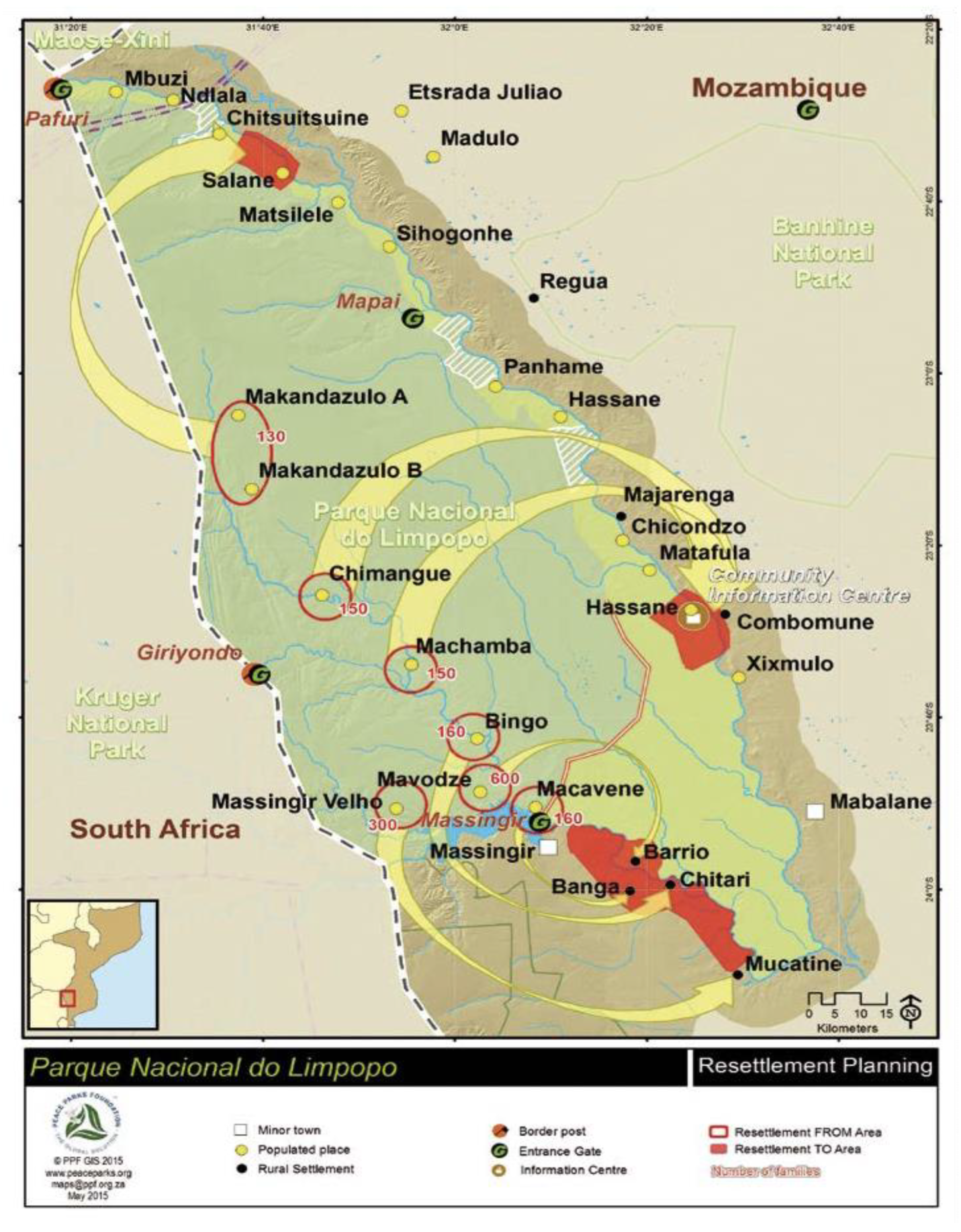
Figure 1.
Massingir District: LNP (Limpopo National Park), buffering zone, dam, biofuel project area, and resettlement areas [14]. The LNP is represented by the dark green color and the buffering zone of the park by the light green color. Massingir Dam is located at the entrance gate of the park, right next to the minor town of Massingir. The arrows point out the areas in which each community inside the park was resettled. The Procana project was to be implemented in the red area surrounding Massingir minor town and the Dam (Banga, Barrio, and Chitari area).


Table 1.
Massingir District’s resource grabbing, synergies, and actors.
| Land Grabs that Answer to | Project | Actors | Prior Use of Land | Main Driver/Goals | Current/New Use of Land |
|---|---|---|---|---|---|
| Energy crisis | Biofuel production | Foreign investors | Food production/subsistence (cattle and plots) | Environmentally friendly and efficiency | Agro-extractivist ethanol project |
| Climate change crisis | Limpopo National Park | Government, World Bank, AFD, KfW, Foreign investors | Food production/subsistence (cattle, fishery, and food crops) | Environmentally friendly and efficiency | Conservation, biodiversity, ecosystems, and tourism investments |
| Protection of biodiversity | Irrigation systems and extension of “agroecology” in the buffer zone | LNP, AFD, KFW, rural households | Food production/subsistence (cattle, fishery, and plots) | Environmentally friendly/efficiency | Protect biodiversity and ecosystems of LNP, food production/subsistence (under the guidelines of LNP and its donors), and tourism |
| Water/Energy | Financialization Massingir Dam rehabilitation | African Development Bank, Government | Food production/subsistence (cattle, fishery, and plots) | Efficiency and environmentally friendly | Irrigation to small, medium, and large-scale projects (including biofuel production and buffering zone), tourism, and energy production |
Source: collected empirical data (interviews with rural households and community leaders) and National Government Strategies and Reports.
Table 2.
Communities affected by the processes of reconcentration of land in Massingir District
| Community | Description | Current Situation | Risks, Losses, and Implications to Livelihoods |
|---|---|---|---|
| Mavodze | Living inside the park and in the process of being resettled | Facing the second wave of expropriation | Unsecure and unsafe environment: people getting injured, cattle attacks, and plots destroyed by animals |
| Restrictions on fishing, grazing land, hunting, and use of forest resources | |||
| Did not get wage employment from the Park | |||
| Macavene | Previously living inside the park but already resettled in Banga | Second wave of expropriation | Loss of land (were given smaller plots to share with households from Banga community) |
| Loss of convenient water sources | |||
| Did not get wage employment from the Park | |||
| Currently have to share the land, water, and public services with Chiangane (Banga Community) | Diminished rights to access to resources—dependent on the goodwill of Banga inhabitants | ||
| Chinhangane (Banga) | Their area was appointed to host Macavene community in an exchange of compensation | Share land and public services with “comers” | Less land to farm and raise cattle (as they have to share with “comers” from Macavene) |
| Increased risk of not getting enough water as demand increased | |||
| Inter and intra-community conflicts | |||
| Buffer Zone communities (BZC) | Previously established in the surrounding areas of the Park | Incorporated into the project financed by AFD and KfW, including irrigation and protection of biodiversity and ecosystems of the park | Loss of decision-making power regarding livelihoods: limitations on the number of cattle to raise and the quantity of production of crops |
| Enforcement of agricultural new techniques | |||
| Restrictions on fishing, hunting, and use of forest resources | |||
| Limitations regarding commercial activities, such as the production of charcoal |
Source: collected empirical data (interviews with rural households and community leaders).
© 2019 by the author. Licensee MDPI, Basel, Switzerland. This article is an open access article distributed under the terms and conditions of the Creative Commons Attribution (CC BY) license (http://creativecommons.org/licenses/by/4.0/).
Share and Cite
MDPI and ACS Style
Bruna, N. Land of Plenty, Land of Misery: Synergetic Resource Grabbing in Mozambique. Land 2019, 8, 113. https://0-doi-org.brum.beds.ac.uk/10.3390/land8080113
AMA Style
Bruna N. Land of Plenty, Land of Misery: Synergetic Resource Grabbing in Mozambique. Land. 2019; 8(8):113. https://0-doi-org.brum.beds.ac.uk/10.3390/land8080113
Chicago/Turabian StyleBruna, Natacha. 2019. "Land of Plenty, Land of Misery: Synergetic Resource Grabbing in Mozambique" Land 8, no. 8: 113. https://0-doi-org.brum.beds.ac.uk/10.3390/land8080113
Note that from the first issue of 2016, this journal uses article numbers instead of page numbers. See further details here.