Article

Opportunities and Limitations for Achieving Land Degradation-Neutrality through the Current Land-Use Policy Framework in Kenya

by
Helene Gichenje
1,*,
José Muñoz-Rojas
1 and
Teresa Pinto-Correia
2
1
Instituto de Ciências Agrárias e Ambientais Mediterrânicas (ICAAM), Universidade de Évora, Campus da Mitra, Ap. 94, 7006-554 Évora, Portugal
2
ICAAM and Departamento de Paisagem Ambiente e Ordenamento, Escola de Ciências e Tecnologia, Universidade de Évora, Ap. 94, 7006-554 Évora, Portugal
*
Author to whom correspondence should be addressed.
Submission received: 11 June 2019 / Revised: 14 July 2019 / Accepted: 24 July 2019 / Published: 26 July 2019
(This article belongs to the Special Issue Land Degradation Neutrality (LDN))

Abstract

:
The United Nations Convention to Combat Desertification (UNCCD) land degradation neutrality (LDN) scientific conceptual framework underscores that LDN planning and implementation should be integrated into existing planning processes and supported by an enabling policy environment. Land-use planning, which requires the integration of different policy goals across various sectors concerned with land-use, can be an effective mechanism through which decisions with respect to LDN can be coordinated. Using Kenya as a case study, we examined current policy instruments that directly or indirectly impact on the use of land in a rural context, to assess their potential to implement LDN objectives. The qualitative content analysis of these instruments indicated that they are rich with specific legal provisions and measures to address LDN, and that there are a number of relevant institutions and structures across governance levels. However, the main shortcoming is the disjointed approach that is scattered across policy areas. Key policy improvements needed to support effective implementation of LDN include: a national soil policy on the management and protection of soil and land; a systematic and coordinated data collection strategy on soils; mobilisation of adequate and sustained financial resources; streamlined responsibilities, and governance structures across national, regional and county levels.

1. Introduction

Land degradation is a serious global environmental and development challenge. According to the Intergovernmental Science-Policy Platform on Biodiversity and Ecosystem Services (IPBES), land degradation is occurring in all parts of the terrestrial world, and is negatively impacting the well-being of at least 3.2 billion people, costing more than 10% of the annual global gross product in loss of biodiversity and ecosystem services [1]. In recognition of the need for continued action on land degradation across impacted countries, regions and landscapes, the Sustainable Development Goals (SDGs), adopted by the global community in 2015, include the following specific target (15.3): “By 2030, combat desertification, restore degraded land and soil, including land affected by desertification, drought and floods, and strive to achieve a land degradation-neutral world” [2]. The United Nations Convention to Combat Desertification (UNCCD) defines land degradation-neutrality (LDN) as a “state whereby the amount and quality of land resources necessary to support ecosystem functions and services and enhance food security remain stable or increase within specified temporal and spatial scales and ecosystems” [3]. The LDN concept expresses the desire to maintain the balance between “not yet degraded” and “already degraded” land [4].
The LDN scientific conceptual framework, as developed by the Science-Policy Interface of the United Nations Convention to Combat Desertification (UNCCD) [5], proposes that the implementation of LDN should be “integrated into existing land use planning processes, and implemented by existing institutions.” According to [5,6] the implementation of specific measures to achieve LDN can be differentiated across the following three states of land: (i) in land that is not degrading, avoiding land degradation involves the use of proactive measures such as appropriate regulation and planning; (ii) in land that is degrading, measures to reduce land degradation can be achieved by incorporating sustainable land management practices; and (iii) in land that is already degraded, interventions are required to reverse degradation through restoration or rehabilitation, which actively assist in the recovery of ecosystem functions. Recognising that “prevention is better than cure,” avoiding degradation is the priority, followed by reducing on-going degradation, then by the restoration and rehabilitation of already degraded land. This sequencing of actions is known as the LDN response hierarchy [5]. Rather than being an additional process, the planning of the appropriate response to address LDN can be made operationally feasible using existing land-use planning processes [7]. Land-use planning, which broadly, aims to allocate land to different uses across a landscape in a way that balances economic, social and environmental values, is a process whereby relevant actors make decisions about how the land and its resources should be used and managed [8]. It requires the coordination of different policy goals across various sectors concerned with land-use and land resources. For the purpose of this study, we define the land-use policy framework to include the policy instruments and associated institutions, which directly or indirectly aim at regulating and influencing land-use in a rural context. Policy instruments (as contained in laws, regulations, policies and plans) are the means through which the government uses “to get people to do things they otherwise would not have done, or it enables them to do things they might not have done otherwise” [9].
To date, a few studies have assessed whether existing laws and policies at the national level are adequate to implement LDN. [10] assessed how the various legal provisions in Germany address actions required along the LDN response hierarchy discussed above, as well as require or allow that degradation is offset by restoration (e.g., permission for a project that would degrade a habitat is granted only if the applicant restores or upgrades land to a functionally equivalent extent). In [11], for the case of Nigeria, it not only examined the extent to which the existing laws and policies engaged with the LDN response hierarchy, but also how the current institutional arrangements and the extent to which various LDN indicators were captured in the policy documents. Both studies noted that the existing laws and policies were not conducive to facilitating implementation of the LDN target, in large part due to the fact that mechanisms to address LDN were scattered across several instruments without much coordination.
Kenya ratified the UNCCD in 1997 [12]. As a tool for implementing the provisions of the convention, Kenya has prepared two National Action Programmes (NAPs), the first in 1999 and the next one in 2002. The 2002 NAP [12] was designed to address the following challenges: inadequate policies and regulatory frameworks; sectoral approaches to programming; uncoordinated and frequent shifts of mandate of dryland issues from one institution to another; low and uncoordinated funding; inadequate involvement of local communities in programming and decision making; and inadequate capacity for implementation, monitoring and evaluation. However, the implementation of the NAP was hampered by weak coordination between the various implementing institutions, and the absence of an overarching monitoring and evaluation framework to guide the scaling-up of activities [13].
Kenya, along with over 120 countries, is part of the UNCCD LDN Target-Setting Programme (TSP) [14]. The TSP provides technical and financial support to countries focused on three key areas: accessing the best available data for target setting; conducting multi-stakeholder consultation processes to mainstream LDN into national SDG agendas; and identifying investment opportunities for LDN implementation [14]. Nonetheless, it remains to be fully explained whether LDN can be effectively implemented under the current land-use policy framework. In this regard, we examined whether the current land-use policy instruments and institutions in Kenya, across governance levels, have the potential to implement LDN objectives. Overall, this study was intended to answer the following two broad research questions:
(i)
Does the current land-use policy framework have the potential to contribute to achieving LDN?
(ii)
What policy and institutional improvements are required to overcome gaps and make the best use of opportunities to advance the pursuit of LDN?
Following this introduction, the next section describes the study area, criteria and methods applied in this study. The third section examines the potential of the current land-use policy framework to address LDN, framed around the LDN responses and a set of enabling conditions. In Section 4 we critically discuss the implications of policy and institutional opportunities and inefficiencies, and provide some key recommendations. The final section presents a synthesis of our main findings and some concluding remarks.

2. Materials and Methods

2.1. Study Area

Kenya is an equatorial country located on the eastern coast of Africa (Figure 1) that extends from 33°9′ E to 41°9′ E and from 4°63′ N to 4°68′ S, and has a total area of 582,646 km2. Most of the country lies within the eastern end of the Sahelian belt, a region that has been severely affected by recurrent droughts over the past decades [15]. At the sub-national level, two counties, Lamu and Makueni, were selected for this study because as of 31 April 2019, both counties had finalised their own county spatial plans. Lamu county is located in the north-eastern end of the Indian Ocean coastline of Kenya, and has a land surface area of 6474 km2 that includes the mainland and over 50 islands [16]. Makueni county has a land surface area of 8035 km2, and is located in the south-eastern region of Kenya, in a predominantly arid and semi-arid region [17].
The LDN national baseline for Kenya was established by Gichenje, H. and Godinho, S [18]. The LDN baseline is the reference state that provides information on where land has degraded or improved, against which neutrality will be assessed. On the basis of the results in the aforementioned paper [18], which used trends in the Normalised Difference Vegetation Index (NDVI), as a proxy for trends in land productivity or the functioning of the land, most of the land area (69.5%) was characterised by non-significant trends (Figure 1). Persistent negative NDVI trends (an indication of land degradation and termed as a browning trend) occurred in 21.6% of the country, while persistent positive NDVI trends (an indication of land regeneration and termed as a greening trend) occurred in 8.9% of the country. Lamu county is primarily characterised by non-significant NDVI trends (95%), while Makueni county has predominantly browning trends (52%). Of note is that the trends illustrated in Figure 1 refer to human-induced trends, as the climate influence was removed from the NDVI trends [18].

2.2. Methods

The methodology adopted in this study primarily involved a content review of official government legal, policy and planning documents. Through this review we also identified the main institutions responsible for the mandate outlined in each of the instruments, and the administrative level at which they operate. We reviewed laws, policies and plans explicitly aimed at regulating land and land-use, and those indirectly influencing the use of land in a rural context. This review was guided as follows. First, in contrast to LDN, which is a relatively new concept, land degradation is not a new environmental challenge for Kenya. Land degradation is a complex multidimensional process that has been defined in many and various ways [19]. For the purpose of this study, the following definition by the UNCCD is adopted: the “loss, in arid, semi-arid and dry sub-humid areas, of the biological or economic productivity and complexity of rainfed cropland, irrigated cropland, or range, pasture, forest and woodlands resulting from land uses or from a process or combination of processes, including processes arising from human activities and habitation patterns” [20]. In its broadest sense, land degradation is the decline in the bio-physical properties of both above and below ground functions and resources. In this regard, we focused on assessing the potential of the current land-use policy framework to address land degradation from this broad perspective related to the management and protection of soil and land. Second, the objective of this study was to assess the potential to address LDN through the intentions expressed in the various instruments examined. The focus was to provide information on intentionality and not on the effectiveness resulting from the implementation of the instruments. Policy instruments are implemented when they are in use and when they have an effect on decisions made by households or farmers [21]. Thus, an assessment of policy effectiveness would require an analysis of management results at the scale at which actions to address land degradation are taken, i.e., landscape, farm or plot, which is outside the scope of our study. Following is an elaboration of the main steps of the methodology.

2.2.1. Criteria for Content Analysis of Legal, Policy and Planning Instruments

The first step comprised of a systematic analysis of official government documents (legislation, policies, strategies, spatial and action plans). Government websites, as well as other online sources were searched to assemble the documents. All documents considered in this analysis were obtained from online sources by the cut-off date of 31 April 2019. Guided by [22] on the identification of themes or criteria in undertaking a qualitative analysis of policy documents, we framed the analysis around a portfolio of options for advancing LDN, as outlined below.
According to [23], LDN can only be achieved through a portfolio of place-based measures that are appropriate to context. Furthermore, one of the key messages emerging from the seminal assessment report on land degradation and restoration [1], is that “eliminating perverse incentives that promote degradation and devising positive incentives that reward the adoption of sustainable land management (SLM) practices are required to avoid, reduce and reverse land degradation.” SLM, as broadly defined by FAO/TerrAfrica in [24], is “the adoption of land use systems that, through appropriate management practices, enables land users to maximise the economic and social benefits from the land whilst maintaining or enhancing the ecological support functions of the land resources.” In line with the LDN response hierarchy proposed by [5] and the need to offset land degradation as proposed by [10], the current instruments would need to propose responses that avoid, reduce, reverse and offset land degradation. Through a review of recent studies and initiatives that document SLM practices in Kenya, we identified some examples of measures that can be implemented across the country’s main productive landscapes. Over the period from 1992 to 2015 agriculture, forest, grassland and shrubland land cover classes accounted for approximately 90% of the area in Kenya [18]. In addition, we identified a number of enabling conditions to support the implementation of LDN. We grouped the enabling conditions into the following 6 broad “means of implementation” [25], identified under SDG 17 that aim to strengthen SDG implementation: finance; technology; capacity building; policy and institutional coherence; multi-stakeholder partnerships; and data, monitoring and accountability. Examples of the means of implementation to support the implementation of LDN were selected based on a number of priority gaps identified in the IPBES report [1].
The LDN responses and the means of implementation were jointly considered as the portfolio of options to address LDN, and as the criteria for undertaking the content analysis of the selected documents (Table 1). Given the predominance of greening and non-significant NDVI trends at the national level (Figure 1), and the precautionary principle underlying the LDN response hierarchy [5], achieving LDN in Kenya at the national level would first require approaches to avoid land degradation, followed by actions to restore and reverse degraded lands. As such, Table 1 represents a LDN operational approach for Kenya, and frames the actions that will need to be implemented using existing laws, policies, plans and related institutions across different land cover types and states of land degradation. Table 1 was populated with examples to guide the review of the various laws, policies and plans. Much of the literature and the practice indicate that similar SLM practices can be implemented where land is and is not degrading [6]. Hence it should be noted that the SLM practices proposed under the reduce/reverse approach can be used to offset land degradation, and should also be used proactively alongside planning, regulatory and management measures to avoid degradation. As grassland and shrubland land cover areas are found primarily in what is commonly referred to as the arid and semi-arid lands (ASALs) of Kenya, we compiled examples for these two land cover types together given the similarity of bio-physical conditions.
Following [22] the content analysis of the selected documents was done by examining the meaning of the text, rather than relying on the presence and frequency of any specific key words. We examined legislation to assess only if they contained requirements that address the LDN responses (i.e., avoid, reduce/reverse and offset), while policies and plans were examined to identify if they included specific measures to address the LDN responses as well as the means of implementation. The analysis was qualitative, resulting in a “yes” or “no” score to indicate the presence or absence of specific examples to address each of the elements of the portfolio of options to address LDN.

2.2.2. Institutional Mapping

Land degradation is a complex process that involves a multiplicity of interconnected environmental, economic and social issues, which cut across the responsibilities of different government agencies [6]. Hence, effectively addressing LDN will require cooperation, collaboration and coordination across actors, sectors, institutions and policy domains [32]. The key institutions established and responsible for the mandate of the various instruments examined, were identified and mapped to evaluate their individual roles and responsibilities. By undertaking the institutional mapping, we sought to highlight the roles of the most relevant institutions with respect to addressing LDN.

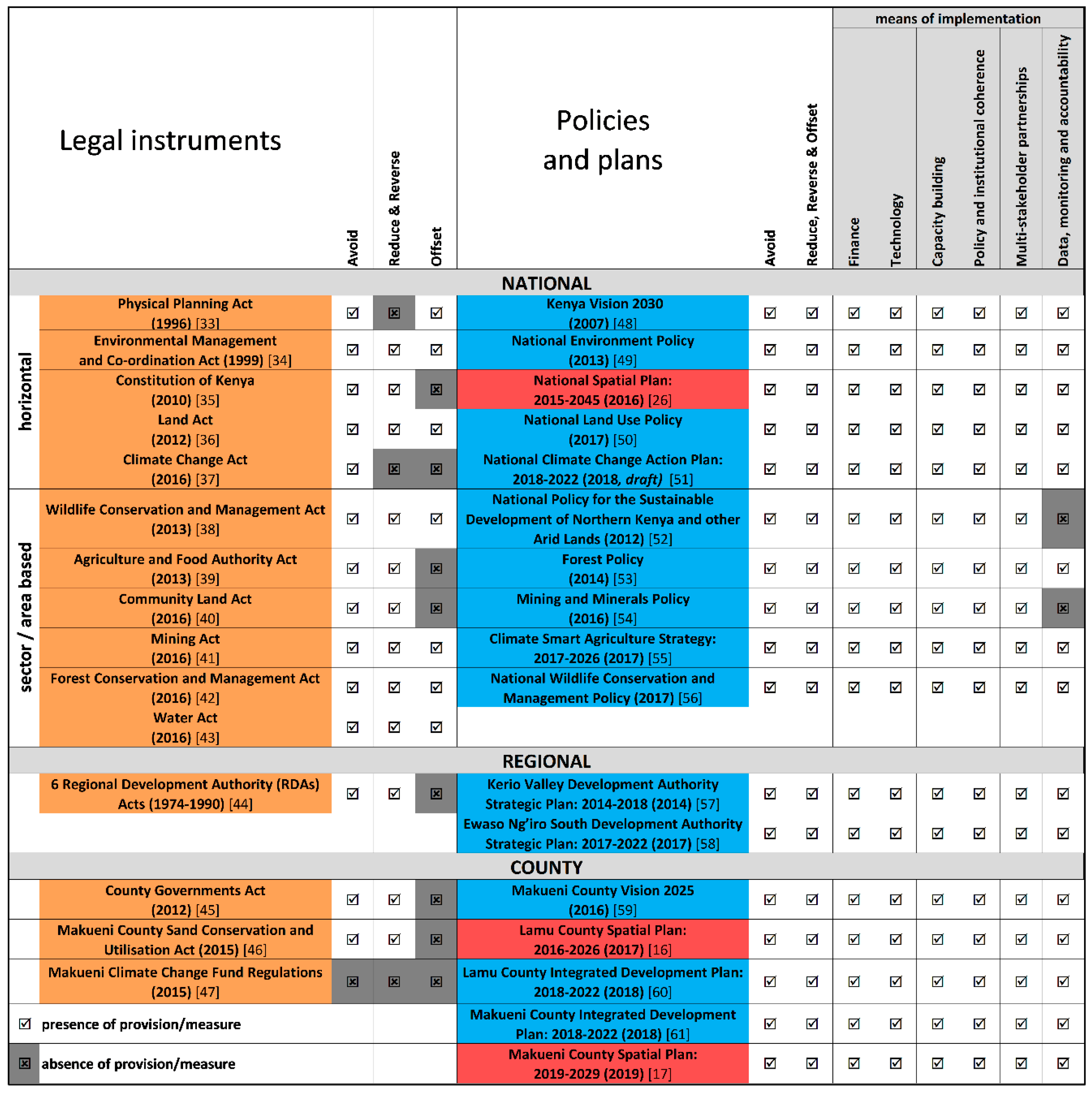
3. Potential of the Current Land-Use Policy Framework to Address LDN

In Kenya, at the national and county levels, there are a number of legal, policy and planning instruments that have the potential for addressing LDN. These instruments fall into 3 main tiers. In the first tier, there are the laws, and include the constitution that is the supreme law of the country, and the various laws (or acts) made by parliament (or county assembly′s), and which must be consistent with the constitution. Secondly, there are the policies, strategies and action plans that are elaborated in relation to specific legislation, and convey what the government intends to achieve. Thirdly, there are the spatial plans, which are the main land-use planning tools that are elaborated at the national and county levels and are intended to provide a framework for the coordinated, integrated and balanced spatial development of the country′s territorial space [26]. The following 32 documents were examined in this study: the national constitution, 14 acts (10 national, 1 regional, and 3 county), 14 policies, including strategies and action plans, (10 national, two regional, three county), and 3 spatial plans (1 national, and 2 county). The results of the content analysis are summarised in Figure 2. To support the review and verification of the analysis undertaken, summaries of specific provisions and measures included in each document are provided in Table S1 (laws), and Table S2 (policies, strategies and plans). These tables do not purport to cover all the possible provisions and measures contained in the documents, but are intended to highlight the breadth and scope of interventions with respect to addressing LDN. Next is an analysis of how the key components of the portfolio of options for addressing LDN (Table 1) are dealt with across the different instruments, followed by a description of the institutional context for addressing LDN.

3.1. Avoid

The avoidance of land degradation has a strong legal basis in the Constitution of Kenya (the Constitution) [35]. The bill of rights as enshrined in the Constitution [35] provides citizens with the right to a clean and healthy environment, which includes the right “to have the environment protected for the benefit of present and future generations.” Constitutional provisions of key relevance to LDN are primarily contained within Chapter 5 on Land and Environment, in which it is stated that government is required to ensure the sustainable use, management and conservation of the environment and natural resources. The Constitution [35] also contains enforcement provisions with respect to the environment in which the state is required to establish systems of environmental impact assessment, and environmental auditing and monitoring, that will enable the state to meet its obligations with respect to, inter alia, eliminating “processes and activities that are likely to endanger the environment” and ensuring “sound conservation and protection of ecologically sensitive areas.” The key legislation that gives full effect to the environment provisions contained in the Constitution is the Environmental Management and Co-ordination Act (EMCA) [34], which contains significant provisions (Part V) for the protection and conservation of the environment. The EMCA is a framework law for environmental management, in which various aspects of the environment are governed through subsidiary legislation (e.g., environmental impact assessment; environmental audit and monitoring; international treaties; environmental restoration; public complaints committee). Further, the EMCA is the overarching law on environmental matters in the country, as Article 148 of the act states that in situations where the provisions of national and county government laws relating to the management of the environment conflict with the act, the provisions of the EMCA shall prevail [34].
The most direct provisions on the protection of soil and land are contained within the following laws, whereby the relevant authorities are given the mandate to undertake the following: EMCA [34]: issue guidelines and prescribe measures for the management and protection of any area declared to be a protected natural environment area; Agriculture and Food Authority Act [39]: prescribe land preservation national guidelines for the purposes of the conservation of the soil, or the prevention of the adverse effects of soil erosion on any land; and Community Land Act [40]: allow registered communities to make rules or by-laws for the conservation and management of the land.
From Figure 2 we note that all the laws examined (except the Makueni Climate Change Fund Regulations [47]) include provisions that contain planning, management and/or regulatory practices to ensure that LDN can be avoided.
Of particular relevance within the various policies and plans are the following measures to avoid degradation. The National Environment Policy [49] states that a National Soil Conservation Policy will be developed (there is no evidence that this has been initiated). To protect natural resources and prevent environmental degradation, the National Land Use Policy [50] advocates for the strengthening of the capacity of regulatory and enforcement agencies, and prohibits settlement and other activities within sensitive ecological zones. The National Spatial Plan (NSP) [26] includes policy statements on: the preparation of integrated management plans for environmentally sensitive areas in wetland, forest, and mountain ecosystems; the development of an integrated land-use master plan for the ASALs; and the need to strictly regulate the subdivision of land in high potential agricultural areas.

3.2. Reduce and Reverse

The majority of laws examined prescribe measures to reduce degradation and/or reverse degraded land (Figure 2). For example: the Constitution [35] includes the target to achieve and maintain a tree cover of at least 10% of the land area; the EMCA (GoK, 1999) prescribes re-forestation and afforestation for the management of hill tops, hill slopes and mountainous areas; the Agriculture and Food Authority Act [39] calls for the provision of guidelines to address the drainage of land, including the construction, maintenance or repair of drains, gullies, contour banks, terraces and diversion ditches; and the Makueni County Sand Conservation and Utilisation Act [46] includes provisions to promote the sustainable use of sand resources through planting of trees, and building of gabions and dams.
The content analysis of the policies and plans indicates that they all include specific measures to reduce/reverse degradation (Figure 2). Examples of measures proposed are: rehabilitation of degraded water catchments; good soil management practices to avert landslides, mudslides, and floods; forest cover through afforestation, reafforestation and agroforestry; species diversification through planting of indigenous and exotic species; restoration of degraded soils and conservation of soil biodiversity through integrated soil fertility management; and preventing encroachment by providing a buffer zone of at least 100 m along the edges of the mangrove ring (Table S2). Of particular note are the targeted interventions identified in the National Climate Change Action Plan (NCCAP) [51], which while aimed at mainstreaming climate change adaption and mitigation actions into sector functions, also comprehensively support the implementation of LDN. Not only are the measures across legal and policy instruments well-aligned with the SLM practices identified in Table 1, there are specific instruments to operationalize LDN actions within the four main land cover classes (e.g., for agriculture areas, the Agriculture and Food Authority Act [39] and the Climate Smart Agriculture Strategy (CSAS) [55]; for forests, the Forest Conservation and Management Act [42], and the Forest Policy [53]; and for ASALs, the Community Land Act [40] and the National Policy for the Sustainable Development of Northern Kenya and other Arid Lands [52]).

3.3. Offset

A number of laws at the national level include clauses with the obligation to offset by restoration any damage or harm done to the environment (Figure 2). The Environmental Restoration Orders contained in the EMCA [34] are the main legal provisions to remedy any environmental or ecological damage resulting from a violation of the EMCA and other laws. These orders place the burden on the wrongdoer to take affirmative steps that will, to the extent feasible, undo the effects of any environmental harm caused. The environmental restoration orders also specify the action that must be taken to remedy the harm to the environment, and the time frame within which the action must be taken. In the case of the Forest Conservation and Management Act [42], and the Wildlife Conservation and Management Act [38], the requirement to offset degradation is contained in restoration clauses with respect to mining and quarrying, which are permitted activities in forests and national parks, under certain conditions.

3.4. Means of Implementation

The majority of the policies and plans contain provisions on the means of implementation of the portfolio of options for addressing LDN (Figure 2), as discussed below.

3.4.1. Finance

A number of dedicated public funds (e.g., the Land Reclamation and Restoration Fund, the Desertification Trust Fund, the National Drought and Disaster Contingency Fund, the Climate Change Fund, the Forest Management and Conservation Trust Fund) are mentioned across the policy and planning documents (Table S2). In addition, the Makueni County Climate Change Fund Regulations [47] establishes the Makueni County Climate Change Fund. Going forward, it will be important to take stock of the experience and effectiveness of these dedicated funds, to draw out lessons on what works and what doesn’t, so as to provide information on the most suitable mechanism for achieving sustainable environmental finance. The policies and plans also included innovative finance mechanisms such as payment for environmental services schemes, carbon markets, green bonds, and insurance schemes (Table S2). Further, at the operational level, the regional and county level documents identify investment marketing and promotion bills, resource mobilization frameworks, and revenue resource mapping as modalities to bridge financial gaps (Table S2).

3.4.2. Technology and Capacity Building

Vision 2030 [48], the country′s long-term development plan, identifies the strengthening of technical capabilities in science, technology and innovation as one of the key foundations for the socio-economic transformation of the country. This goal has filtered down into the policies and plans which include statements related to promoting scientific research and technical capabilities, e.g., conduct research on natural resource and environment conservation technologies (National Land Use Policy [48]); capacity development of at least 50 Water Resources Users Associations (NCCAP [51]); strengthen research and extension systems relevant to rain-fed crop production, including soil and water conservation, organic farming and agroforestry (National Policy for the Sustainable Development of Northern Kenya and other Arid Lands [52]); key decisions on forest management and conservation shall be informed by forestry science founded on appropriate knowledge derived from research (Forest Policy [53]); and enhance human capacity in weather data collection, and analysis of government staff, traditional weather forecasters, and communities (CSAS [55]).

3.4.3. Policy and Institutional Coherence

While the policy and planning documents examined contain different statements on the means to attain coherence (e.g., mainstreaming of climate change, securing rights in land, and harmonising policy agendas with other relevant policy areas and instruments) (Table S2), in this section we focus on spatial planning, which as previously stated is Kenya’s main land-use planning tool. Spatial planning aims at balancing the different demands for land-use in order to ensure that competing policy goals are reconciled, and can be an effective tool to achieve land management coordination horizontally (across different land-use decision makers) and coherence vertically (across governance levels) [62]. Kenya′s first spatial plan, the National Spatial Plan (NSP), is intended to guide the long-term spatial development of the country for a period of 30 years (2015–2045) [26]. The main spatial organisation of the NSP is the National Spatial Structure (NSS), which was developed not only in consideration of the geography, physiography and natural resource endowments of the country, but also on an analysis of the trends in economic performance, population and demographic dynamics, land use patterns, and human settlements. The NSS provides a spatial illustration of national projects and other socio-economic development policies. For example, there are 3 terrestrial-based spatial areas defined for the agricultural sector in the NSS: ASALs, high agriculture potential areas, and medium agriculture potential areas. The NSP proposes that the ASALs should be developed for large-scale commercial production of livestock. In high agriculture potential areas, the proposed strategy is intensification to increase productivity. While medium agriculture potential areas are to be optimised by promoting investment in irrigation agriculture for high value crops. At the national level, agriculture land cover areas have the highest browning trends [18], indicating that this land cover type should be the priority for the implementation of reduce/reverse response measures. Thus, the proposed strategies indicated above for agricultural areas, should only be considered once measures have been taken to mitigate land degradation in agricultural areas with browning trends.
The Lamu and Makueni county spatial plans [17,18], in contrast with the strategic nature of the NSP, are operational documents as they are planned for a 10-year time frame. Both county spatial plans contain sections devoted to situating the county planning within the national policy and planning contexts (e.g., the Constitution, the NSP). The spatial organisation concepts in the county spatial plans related to rural land-use, designate areas for their agricultural productive potential and for environmental protection, two strategies that are aligned with the NSP. Different LDN response strategies are required in the two counties. In Makueni county, across the 4 main land cover types, browning trends are approximately 50% of the share of the trends, which calls for more focused implementation of reduce/reverse response measures (such as afforestation, rehabilitation of water catchment areas, promotion of soil conservation, as indicated in Table S2 across the Makueni policy and planning documents). In Lamu county, non-significant trends are predominant across the main land cover types, indicating that the priority is to avoid land degradation through appropriate regulation, planning and management practices. In this regard, the Lamu County Integrated Development Plan [60] advocates for the formulation of laws, policies, strategies and regulations on the use of land (Table S2).
In addition to the global development agenda (i.e., the SDGs), Kenya also adopted the African Union′s long-term vision, Agenda 2063 [63]. Existing planning processes are intended to support the integration of global and regional development agendas at the national and sub-national levels. Specifically, Kenya′s long-term development plan, Vision 2030 [48], is implemented through a series of 5-year medium-term plans (MTPs) at the national level. The Third MTP for the period 2018–2022 [64] articulates that it aims to implement policies, programmes and projects to facilitate the attainment of the SDGs, as well as the priorities of the first ten-year implementation plan of Agenda 2063. At the county level, the CIDPs are intended to be aligned to the national MTP, and by extension are vehicles for the implementation of internationally agreed development goals.

3.4.4. Multi-Stakeholder Partnerships

Enshrined within the Constitution [35] are legal provisions that provide for public participation in the management, protection and conservation of the environment, as well as for the protection of indigenous knowledge. As a result, the policies and plans contain strong statements on the need for participatory approaches. Examples of this are provided in the guiding principle of the National Environment Policy [49] and the Forest Policy [53], whereby coordinated and participatory approaches are advocated for the protection and management of environmental and forest resources. Ultimately, participatory mechanisms aim to ensure that state and non-state actors interact in planning, implementation and decision-making processes. Among the key non-state actors in Kenya are the multilateral agencies and bilateral donors that provide financial, technical and capacity development support. Other non-state actors (both international and local) include civil society and private sector organisations that are involved in a range of roles including advocacy, community empowerment, policy analysis, and technical support. The formal multi-stakeholder forums created under the different instruments are discussed below in the institutional context section.

3.4.5. Data, Monitoring, and Accountability

Several policy and planning instruments contain requirements specifically related to soil and land data, and some more generally on reporting on the status of environment resources. For example: the National Environment Policy [49] proposes that a national data and information management policy on environmental and biological resources be developed, and requires that there is periodic reporting on county and national status of the environment; the National Land Use Policy [50] states that the assessments of land resources needs to be carried out, including basic soil surveys, farming systems, soil degradation surveys as well as production potentials of the soils in the country, and requires that the Ministry of Lands prepare a status report on land-use in Kenya once every 10 years for rural areas; the EMCA [34] requires that the NEMA prepare an annual report on the state of the environment in Kenya; the Forest Policy [53] states that reports on the status and resource assessments of forests will be published on a regular basis; the NSP [26] requires that status reports on the implementation of the NSP be prepared by the national government periodically, and by the county government annually. At the operational level, the regional and county level policies and plans included different mechanisms for measuring the outcome and impact of activities, e.g., systematic data collection of planned activities, outputs and outcomes for tracking progress and informing decision-making; and requirements on indicator identification, frequency of data collection, responsibility for data collection, data analysis and use (Table S2).

3.5. Institutional Context

The responsibility for addressing LDN is spread across nine national ministries, six regional development authorities (RDAs), 47 county governments and legislative assemblies, as well as the three branches of the national government (the Executive; Parliament; and Judiciary) (Figure 3). Administratively, the country is made up of two formal levels of government: the national government and 47 semi-autonomous county governments, which were created by the Constitution [35] as the new devolved units of governance. Each county has its own government with local representation in the form of elected governors and members of county assemblies. In the context of the LDN, Schedule 4 of the Constitution [35] delineates responsibilities between the national and county government as follows. The national government is responsible for: general principles of land-use planning and the co-ordination of planning by the counties; protection of the environment and natural resources, in particular: fishing, hunting and gathering; protection of animals and wildlife; disaster management; and agricultural policy. The responsibilities of the county government include the implementation of specific national government policies on natural resources and environmental conservation, including soil and water conservation, and forestry. In addition, through the County Governments Act [45], each county is mandated to carry out critical planning functions, including the responsibility to prepare a county spatial plan, with the aim (inter alia), to protect and develop natural resources in a manner that aligns with national and county policies. Clustered along a number of key roles, Table S3 illustrates the institutions, agencies, committees, associations and forums that, across administrative levels, play various roles with respect to the implementation of government functions (including policy, regulatory, research and training, service provision, etc.), and also support the coordination within and between the national government, the county governments, and relevant stakeholders.
Under the Ministry of Environment and Forestry, the National Environment Management Authority (NEMA) is the principal institution with the responsibility for the coordination and implementation over all matters and policies relating to the environment, including environmental international conventions, and the development and enforcement of environmental standards and regulations. Two other national environmental oversight bodies are the Environment and Land Court (with duties that include hearing and ruling on matters related to the environment, and on the use and occupation of, and title to, land), and the National Environmental Tribunal (with the mandate to hear disputes arising from NEMA decisions, as well as appeals made in relation to other acts). As the National Environment Policy [49] is anchored on the principle of subsidiarity that provides decentralised and devolved authority and responsibility for management of the environment and natural resources to the lowest level possible, the obligation to take action on land degradation rests at the county level. At the county level, an example of a multi-stakeholder forum is the County Environment Committee. Established under the EMCA [34], it is to be represented by the following: county government; national government (including an officer of the NEMA); every Regional Development Authority whose area of jurisdiction falls wholly or partially within the county; and non-governmental actors from within the county (farmers or pastoralists, business community, environmental management organisations).
The agriculture sector is a cornerstone of Kenya′s economy, and plays a key role in shaping the rural productive landscapes. It directly contributes approximately 33% of the total Gross Domestic Product (GDP), and about 70% of the rural population is engaged in this sector [65]. To facilitate horizontal coordination across the national government on agriculture, the CSAS [55] identifies the roles that various ministries (e.g., energy, land, environment) are expected to play in support of the implementation of the strategy. In accordance with the Intergovernmental Relations Act [66] that provides the legal framework for the consultation and cooperation between the national and county governments and amongst county governments, the following three mechanisms facilitate the coordination of the agriculture sector [67]: the Intergovernmental Forum on Agriculture, co-chaired by the Cabinet Secretary of the ministry responsible for agriculture and by the Chair of the Council of Governors, provides a platform for stakeholder consultations and cooperation, and also approves and makes recommendations on programmes, strategies, plans and performance monitoring instruments; the Joint Agriculture Sector Steering Committee (JASSCOM) provides technical direction for sector transformation initiatives agreed between the two levels of government; and the Joint Agriculture Sector Technical Working Groups are the platforms for intergovernmental technical consultations organized along a number of working groups (e.g., crops, livestock, fisheries, irrigation), and responsible for preparing and submitting reports to the JASSCOM.
To further the coordination and coherence in the implementation of the NSP [26], the following three institutional arrangements are proposed. The National Physical Planning Council, to be chaired by the President of Kenya, is to be responsible, among others, for providing policy guidance for the implementation of strategic spatial projects of national importance, and is to be composed of: Cabinet Secretaries of relevant ministries (e.g., Economic Planning, Devolution, Agriculture, Tourism, Environment, Transport and Infrastructure); Governors from all the counties; and representatives of state agencies. The National Technical Committee, composed of the National Director of Physical Planning (Ministry of Lands), Directors from the various relevant national departments, as well as County Directors of Physical Planning, is responsible for providing technical leadership and ensuring that physical planning is coordinated within the national government. The County Physical Planning Committee is responsible for ensuring that the aspirations of the NSP [26] are articulated in the preparation of county plans, and is chaired by the Governor of the county, and composed of the Deputy Governor, County Executive Committee members from various sectors, and directors from various relevant County departments (e.g., Lands and Physical Planning, Economic Planning, Agriculture, Tourism, Environment).
Sandwiched between the national government and county governments are the six RDAs whose main mandate, as spelt out in the six individual RDA Acts [44], is to plan and co-ordinate the implementation of development projects within river basins. Examples of other structures that exist at the regional level are the Basin Water Resource Committees (a multi-stakeholder forum established under the Water Act [43] and responsible for the management of the water resources within a respective basin area) and the Forest Conservation Committee (a multi-stakeholder forum established under the Forest Conservation and Management Act [42] to make recommendations to the relevant national and county government organisations in relation to the conservation and utilisation of forests).

4. Discussions

The content analysis undertaken in this study has served to demonstrate that the policy instruments (the national constitution, 14 laws, 14 policies (includes strategies and action plans) and three spatial plans) were rich with specific legal provisions and measures that broadly address the portfolio of options to address LDN (i.e., the placed-based measures that are appropriate to the Kenyan context, as presented in Table 1). We can affirmatively respond to our first broad research question that the current land-use policy framework has the potential to contribute to achieving LDN, as demonstrated by the pertinent measures contained across policy instruments, and the presence of relevant institutions and structures across governance levels. However, the main shortcoming in the current land-use policy framework is the disjointed approach on the management and protection of soil and land, that is scattered across various policy areas. For example, the following laws each individually prescribe for the development of guidelines or regulations for the management of and protection of soil and land: the EMCA [34], the Agriculture and Food Authority Act [39], and the Community Land Act [40]. Notwithstanding the lack of a systematic approach to addressing LDN, the following opportunities were evident.
First, Kenya has a strong legal foundation to address LDN that is anchored in the Constitution [35]. Entrenched within the Constitution are the environmental rights of citizens, the obligations of the state for sustainable environmental management, as well as guiding norms and principles with respect to public participation and safeguarding of indigenous knowledge. The strategic and principle-orientated vision on the environment articulated in the Constitution [35] pervades to other lower legal, policy and planning instruments, and provides for a powerful and potentially transformative step towards attaining environmental sustainability [68], and more specifically, for addressing LDN. Legal requirements to address the LDN responses, i.e., avoid, reduce/reverse and offset, are contained in a number of laws (Figure 2). However, the EMCA [34], (which has undergone a number of amendments over time to give full effect to the provisions of the constitution) with its subsidiary legislation and regulatory institutions, is the legislation for environmental management that takes precedence and has the potential to coordinate other horizontal and sectoral laws and policies with mandates relevant to the management and protection of soil and land. As noted by [10], in the absence of an overarching holistic concept for land and soil protection, the key priority for governments is to effectively use existing laws, and in the case of Kenya, particularly the EMCA [3],4 for the purpose of achieving LDN. A key starting point would be the strengthening of the capacity of regulatory, enforcement and coordination agencies (e.g., NEMA, the Kenya Forest Services, the Kenya Wildlife Services (Table S3)), as advocated in the National Land Use Policy [50]. The enhanced capacity of these agencies would help deter processes and activities that are likely to lead to the degradation of land.
Second, while specific measures to address the portfolio of options to address LDN are scattered in a number of laws, policies and plans (Figure 2), the implementation of various initiatives contained within the following instruments would give teeth to addressing LDN. As proposed in the National Environment Policy [49], the development of a National Soil Conservation Policy could provide an overarching policy framework on land and soil protection to overcome the existing fragmentation. The assessments of land resources (including basic soil surveys, farming systems, soil degradation surveys) as suggested in the National Land Use Policy [50], would provide data and information on where land has degraded or regenerated and a sound basis for decision-making to address LDN. In addition, given the comprehensive nature of the targeted land-based climate change adaptation and mitigation interventions articulated in the NCCAP [51], this action plan could be used as a first step towards implementing LDN, and as a tool for addressing synergies between climate change and land degradation.
Third, the strategic orientated, long-term (30-year planning horizon) NSP [26] is well placed to play a critical role in the integration and coordination of policy agendas across key development, socio-economic and environmental sectors, institutions, and actors, at the national, regional and county levels. Among the mechanisms suggested by [32] to overcome the challenges related to the integration of LDN into existing land-use planning processes are: a proactive, forward-thinking and precautionary decision culture; strategic decision making, which is long-term, encompasses all spatial/organisational levels, and is supported by suitable instruments; and participatory modes of governance and decentralised planning. Notwithstanding the reporting requirements and the institutional structures of the NSP, there is an absence of information on how the requirements set out in the NSP will be complied with and enforced. This presents an opportunity for the development of a robust monitoring and evaluation framework for the NSP, with strong compliance and enforcement components, as well as on mechanisms to ensure effective feedback on the performance of the spatial plan across sectors and governance levels.
Relying on the current land-use policy framework to address LDN will likely result in some gaps and anomalies. Reports from the pilot countries participating in the LDN TSP indicate that every country has its own cocktail of challenges, including so called “failures of the past” [69]. In light of the challenges the 2002 NAP [12] was designed to address, the assessment carried out in the current study has indicated a number of failures of the past. Specifically, the current land-use policy framework was weak on coherently addressing: data on the existing soil and land conditions; secure funding for implementation of LDN initiatives; and clear delineation of responsibilities across various levels of government. Following is a discussion on the key policy and institutional improvements required to advance the pursuit of LDN in Kenya.
As land degradation is not a static state, but rather, a continuum, monitoring of the rates, causes, and effects of land degradation will need to be done continuously, with sequential updates [70]. While a number of laws, policies and plans contain requirements specifically related to soil and land data, an important gap, and perhaps the most important barrier to achieving the LDN objective in Kenya, is the lack of systematic and coordinated data collection strategy on soils and the impacts of land degradation. One of the 3 biophysical metrics proposed by the UNCCD to measure LDN is soil organic carbon (SOC) [71]. However, in Kenya, there is no uniform national coverage of SOC data due to the limited number of soil profiles, nor any SOC trend data [18]. SOC is arguably one of the most important soil indicators because of its central role in a range of soil functions, including its known benefits for improved soil fertility and productivity, and its contribution to food security [72]. [73] demonstrate the linkage of soil functions across several of the SDGs (e.g., food security, human health, biodiversity preservation, water security, and climate change), and advocate for the cheap and reliable monitoring of SOC. This implies that investment by countries in the collection of SOC stock data would not just be for the purpose of monitoring the LDN goal, but would also provide information more broadly to support implementation of a number of SDGs. However, field measurement of SOC, and other soil properties, is a resource-intensive exercise in terms of labour, time and money [74]. In consideration of these barriers, machine learning prediction and remote sensing approaches offer cost-effective techniques for mapping a number of soil properties including SOC [75,76], and are areas that would benefit from government support for scientific and technical research. Further, as land degradation cannot “be judged independently of its spatial, temporal, economic, environmental and cultural context” [77], concerted data collection on socio-economic and cultural factors, and their interactions over time and space, will be required to provide information into the planning processes that address LDN.
While the implementation of some SLM measures (Table 1) are likely to be within reach of many land users [6], significant investments will be required to coherently implement transformative LDN programmes and projects, that include sustainable interventions at scale, while featuring innovation in terms of locally adapted technologies, inclusive governance arrangements, and financial mechanisms [78]. Given that funding for LDN initiatives from the national budgets may not be sufficient, and that the UNCCD′s financial mechanisms (the Global Mechanism and the Global Environment Facility) have not mobilised enough resources to implement the Convention [69], countries will need to pursue strategies to attract innovative sources of funding. One such source is the independent LDN Fund that pools capital from public and private sources to support LDN initiatives [79]. Operational since the end of 2018, the LDN Fund has made its first investment in Latin America in a programme focused on restoring degraded land and promoting SLM [80].
Other innovative sources of funding include market-based approaches, such as financial and economic instruments, payments for ecosystem services, farm subsidies, conservation tenders and biodiversity offsets [1]. The legal, policy and planning instruments included a number of these innovative finance mechanisms as well as dedicated funds (Tables S1 and S2). Further, at the operational level, the regional and county level documents contained statements on the need to bridge financial gaps and attract additional investments for projects by engaging external partners, particularly the private sector. To ensure that sufficient funding is available for LDN implementation over an extended period, Kenya will need to harness a mixture of financial sources and mechanisms, but more importantly, create a coherent and enabling environment for LDN investments [69].
Furthermore, to effectively address LDN, greater governmental collaboration and cooperation is necessary across the responsibilities of different government agencies in order to: bring together the fragmented knowledge base on e.g., agriculture, rangeland management, meteorology, hydrology, soil science, indigenous and local knowledge; incorporate the input of all relevant stakeholders; bridge the science-policy divide; and implement coordinated activities at the national level that will also interact with the community and international levels [6]. With respect to environment functions, the Constitution [35] delineates specific roles and tasks to the national and county governments (Section 3.5). While no role for the RDAs is provided in the Constitution of Kenya, the responsibility for the 6 RDAs is subsumed under the Ministry of East African Community and Regional Development (Table S3). In this context, there is need to clearly delineate responsibilities at the national, regional and county levels so as to avoid the duplication of roles, as well as to streamline the implementation of interventions to address LDN.
The national government needs to play the following key functions: policy coherence and coordination on the management of soils and land, first and foremost through the elaboration of the National Soil Conservation Policy; designating at the national level the main agency that will be responsible for LDN implementation; enhancing the capacity for the effective enforcement of environmental legislation through the NEMA and other national enforcement and coordination agencies (Table S3); developing a national soil reporting framework with standardised rules and protocols and designating the national agency to lead on this activity; creating a coherent and enabling environment for LDN investments to attract, in particular, innovative sources of LDN funding; strengthening the compliance and enforcement mechanisms related to spatial planning; targeted research to further enable evidence-based decisions regarding land degradation and restoration [1], through the specialised agencies (e.g., Kenya Agricultural and Livestock Research Organization, Kenya Forestry Research Institute) (Table S3); meeting the reporting requirements as stipulated in various instruments; and streamlining governance structures to enable effective interactions among the numerous actors across national, regional and county levels and across policy domains.
At the sub-national level, the UNCCD TSP proposes the analysis and contextualisation of LDN at the watershed scale to provide decision support for the formulation of policies and programmes towards transformative LDN interventions [81]. The RDAs, established based on river basins and large water bodies, offer an entry point for the implementation of landscape-scale approaches that integrate the development of agricultural, forest, energy, water and infrastructure agendas [1]. Another feasible entry point for implementing LDN at the landscape-scale would be within areas with community land tenure. The new Community Land Act [40] provides a broad framework for the management and administration of community land, and promises land security for approximately 6 to 10 million people primarily in ASAL areas [82]. Land tenure insecurity can prevent farmers from adopting SLM practices [28]. With greater security of access to and use of natural resources by communities, proven SLM practices could be brought to scale on community lands.
The 47 counties represent the lowest devolved units of government in Kenya. As most land management decisions take place at individual farm scale [28], the decentralization of a number of national government functions to the county level presents an enormous opportunity to address LDN in a tangible way. The local-scale and biophysical and socioeconomic contexts within which land degradation occurs [70], implies that counties, which operate closest to the people, can better target SLM interventions. To improve on policy design and implementation a better understanding is required of the relationship between farmers’ decisions, land-use change and public policies [83]. Further, since the choice of land management practices adopted by rural households is context dependent and a product of many factors [84,85], county governments need to better target a range of services, particularly extension and research, and to strengthen research-extension-farmer linkages to better select appropriate response options and inform LDN policy and implementation gaps.

5. Conclusions

The current land-use policy framework in Kenya forms a strong platform for addressing LDN. However, an overarching approach on the management and protection of soil and land is required to ensure that Kenya can effectively achieve the LDN target by 2030. The qualitative content analysis of the national constitution, 14 laws, 14 policies (includes strategies and action plans) and three spatial plans, across institutional and governance levels, highlighted that: there is a strong legal foundation to address LDN that can be anchored in the guiding principles and entrenched environmental rights provided in the national constitution; the targeted land-based climate change adaptation and mitigation interventions articulated in the NCCAP [51] could be used as a vehicle to support effective synergies between climate change and land degradation; and, the integrative potential of the strategically orientated NSP [26] can be realised through mechanisms that ensure compliance and enforcement across policy domains and governance levels.
Relying on the current land-use policy framework to address LDN will likely result in some gaps and anomalies. Key policy and institutional improvements needed to support effective implementation of LDN include putting in place: a national soil conservation policy to provide an overarching policy framework on land and soil protection; a systematic and coordinated data collection strategy on soils and the impacts of land degradation; mechanisms for the mobilisation of adequate and sustained financial resources; streamlined responsibilities and governance structures across national, regional and county levels. While the focus of this analysis has been on public policies, processes and agencies, numerous and diverse non-governmental actors also play a crucial role in the protection and management of soil and land in Kenya. Hence, across all levels of government, platforms, pathways and incentives need to be strengthened and/or created to effectively facilitate the role of diverse stakeholders.
The participation by Kenya in the UNCCD TSP programme presents an opportune time to integrate the reforms discussed above in the formulation of a new NAP to outline how LDN will be achieved by 2030. Specifically, the new NAP should be action-orientated and fully financed, and focused on steering Kenya towards the implementation of better land management practices. In a country like Kenya, where soil and land fundamentally underpin livelihoods and economic activity, the sense of urgency and priority given to creating an enabling policy environment for improving the condition of degraded ecosystems and to promoting sustainable land management, cannot be overstated.

Supplementary Materials

The following are available online at https://0-www-mdpi-com.brum.beds.ac.uk/2073-445X/8/8/115/s1, Table S1: Provisions and measures included in the main laws relevant for addressing LDN, Table S2: Provisions and measures included in the main policies and plans relevant for addressing LDN, Table S3: Key public institutions at the national, regional and county level with a mandate relevant to LDN.

Author Contributions

Conceptualization, all authors; formal analysis, H.G.; methodology, H.G. and J.M.-R.; writing—original draft preparation, H.G.; writing—review and editing, all authors.

Funding

This work was funded by National Funds through FCT Foundation for Science and Technology under the Project UID/AGR/00115/2019.

Conflicts of Interest

The authors declare no conflict of interest.

References

  1. Intergovernmental Science-Policy Platform on Biodiversity and Ecosystem Services (IPBES). Summary for Policymakers of the Assessment Report on Land Degradation and Restoration of the Intergovernmental Science-Policy Platform on Biodiversity and Ecosystem Services; Scholes, R., Montanarella, L., Brainich, A., Barger, N., ten Brink, B., Cantele, M., Erasmus, B., Fisher, J., Gardner, T., Holland, T.G., et al., Eds.; IPBES Secretariat: Bonn, Germany, 2018; Available online: https://www.ipbes.net/assessment-reports/ldr (accessed on 1 November 2018).
  2. United Nations (UN). Revised list of global Sustainable Development Goal Indicators. Report of the Inter-Agency and Expert Group on Sustainable Development Goal Indicators (E/CN.3/2017/2); Annex III; UN: New York, NY, USA, 2017; Available online: https://unstats.un.org/sdgs/indicators/Official%20Revised%20List%20of%20global%20SDG%20indicators.pdf (accessed on 1 November 2018).
  3. United Nations Convention to Combat Desertification (UNCCD). Report of the Conference of the Parties on Its Twelfth Session (ICCD/COP(12)/20/Add.1); UNCCD: Bonn, Germany, 2015; Available online: https://www.unccd.int/official-documents/cop-12-ankara-2015/iccdcop1220add1 (accessed on 1 November 2018).
  4. Kust, G.; Andreeva, O.; Cowie, A. Land degradation neutrality: Concept development, practical applications and assessment. J. Environ. Manag. 2017, 195, 16–24. [Google Scholar] [CrossRef] [PubMed]
  5. Cowie, A.L.; Orr, B.J.; Sanchez, V.M.C.; Chasek, P.; Crossman, N.D.; Erlewein, A.; Louwagie, G.; Maron, M.; Metternicht, G.I.; Minelli, S.; et al. Land in balance: The scientific conceptual framework for land degradation neutrality. Environ. Sci. Policy 2018, 79, 25–35. [Google Scholar] [CrossRef]
  6. Chasek, P.; Safriel, U.; Shikongo, S.; Fuhrman, V.F. Operationalizing zero net land degradation: The next stage in international efforts to combat desertification? J. Arid. Environ. 2015, 112, 5–13. [Google Scholar] [CrossRef]
  7. Orr, B.J.; Cowie, A.L.; Castillo, V.M.; Chasek, P.; Crossman, N.D.; Erlewein, A.; Louwagie, G.; Maron, M.; Metternicht, G.I.; Minelli, S.; et al. Scientific Conceptual Framework for Land Degradation Neutrality. A Report of the Science-Policy Interface; UNCCD: Bonn, Germany, 2017; Available online: https://www.unccd.int/publications/scientific-conceptual-framework-land-degradation-neutrality-report-science-policy (accessed on 1 November 2018).
  8. Food and Agriculture Organization of the United Nations (FAO). Guidelines for Land-Use Planning. 1993. Available online: http://www.fao.org/3/t0715e/t0715e00.htm (accessed on 1 November 2018).
  9. Schneider, A.; Ingram, H. Behavioral assumptions of policy tools. J. Politics 1990, 52, 510–529. [Google Scholar] [CrossRef]
  10. Bodle, R. Implementing land degradation neutrality at national level: Legal instruments in Germany. In International Yearbook of Soil Law and Policy; Ginzky, H., Dooley, E., Heuser, I., Kasimbazi, E., Markus, T., Qin, T., Eds.; Springer: Cham, Switzerland, 2017. [Google Scholar]
  11. Speranza, C.I.; Adenle, A.; Boillat, S. Land degradation neutrality—Potentials for its operationalisation at multilevels in Nigeria. Environ. Sci. Policy 2019, 94, 63–71. [Google Scholar] [CrossRef]
  12. Government of Kenya (GoK). National Action Programme: A Framework for Combatting Desertification in Kenya in the Context of the United Nations Convention to Combat Desertification. 2002. Available online: https://knowledge.unccd.int/sites/default/files/naps/kenya-eng2002.pdf (accessed on 1 November 2018).
  13. World Bank. Kenya Agricultural Productivity and Sustainable Land Management Project—Project Appraisal Document. 2010. Available online: http://documents.worldbank.org/curated/en/675841468273620112/pdf/402960PAD0P0881Official0use0Only191.pdf (accessed on 5 March 2019).
  14. UNCCD. The LDN Target Setting Programme. 2019. Available online: https://www.unccd.int/actions/ldn-target-setting-programme (accessed on 5 March 2019).
  15. Leroux, L.; Bégué, A.; Seen, D.L.; Jolivot, A.; Kayitakire, F. Driving forces of recent vegetation changes in the Sahel: Lessons learned from regional and local level analyses. Remote Sens. Environ. 2017, 191, 38–54. [Google Scholar] [CrossRef] [Green Version]
  16. Government of Lamu County (GoL). Lamu County Spatial Plan: 2016–2026. 2017. Available online: http://www.kpda.or.ke/documents/County_Spatial_Plans/Lamu%20County%20Spatial%20Plan%20ARBRIDGED%20VERSION%20Vol%20II.pdf (accessed on 1 November 2018).
  17. Government of Makueni County (GoM). Makueni County Spatial Plan: 2019–2029. 2019. Available online: https://makueni.go.ke/downloads/ (accessed on 1 May 2019).
  18. Gichenje, H.; Godinho, S. Establishing a land degradation neutrality national baseline through trend analysis of GIMMS NDVI time-series. Land Degrad. Dev. 2018, 29, 2985–2997. [Google Scholar] [CrossRef]
  19. Yengoh, G.T.; Dent, D.; Olsson, L.; Tengberg, A.E.; Tucker, C.J. The Use of the Normalized Difference Vegetation Index (NDVI) to Assess Land Degradation at Multiple Scales: A Review of the Current Status, Future Trends, and Practical Considerations. Lund University Center for Sustainability Studies (LUCSUS), and The Scientific and Technical Advisory Panel of the Global Environment Facility (STAP/GEF). 2014. Available online: https://0-www-springer-com.brum.beds.ac.uk/gp/book/9783319241104 (accessed on 1 November 2018).
  20. UNCCD. United Nations Convention to Combat Desertification in Countries Experiencing Serious Drought and/or Desertification, Particularly in Africa. 1994. Available online: https://www.unccd.int/sites/default/files/relevant-links/2017-01/UNCCD_Convention_ENG_0.pdf (accessed on 5 March 2019).
  21. Primdahl, J.; Brandt, J. CAP, nature conservation and physical planning. In CAP and the regions: Building a Multidisciplinary Framework for the Analysis of the EU Agricultural Space; Laurant, C., Bowler, I., Eds.; INRA: Paris, France, 1997; pp. 177–186. Available online: https://rucforsk.ruc.dk/ws/portalfiles/portal/37539166/CAP_Nature_Conservation_and_Physical_Planning.pdf (accessed on 5 March 2019).
  22. Le Gouais, A.; Wach, E. A Qualitative Analysis of Rural Water Sector Policy Documents. Water Alternatives. 2013, 6, 439–461. [Google Scholar]
  23. Akhtar-Schuster, M.; Stringer, L.C.; Erlewein, A.; Metternicht, G.; Minelli, S.; Safriel, U.; Sommer, S. Unpacking the concept of land degradation neutrality and addressing its operation through the Rio Conventions. J. Environ. Manag. 2017, 195, 4–15. [Google Scholar] [CrossRef]
  24. Liniger, H.P.; Studer, R.M.; Hauert, C.; Gurtner, M. Sustainable Land Management in Practice: Guidelines and Best Practices for Sub-Saharan Africa. TerrAfrica, World Overview of Conservation Approaches and Technologies (WOCAT) and Food and Agriculture Organization of the United Nations (FAO). 2011. Available online: http://www.fao.org/docrep/014/i1861e/i1861e.pdf (accessed on 1 November 2018).
  25. Stafford-Smith, M.; Griggs, D.; Gaffney, O.; Ullah, F.; Reyers, B.; Kanie, N.; Stigson, B.; Shrivastava, P.; Leach, M.; O’Connell, D. Integration: The key to implementing the Sustainable Development Goals. Sustain. Sci. 2017, 12, 911–919. [Google Scholar] [CrossRef]
  26. GoK. National Spatial Plan: 2015-2045. 2016. Available online: http://lands.go.ke/wp-content/uploads/2018/11/NSPM-2015-2045-combined-low-res.pdf (accessed on 1 November 2018).
  27. Glenday, J. Carbon storage and emissions offset potential in an East African tropical rainforest. For. Ecol Manage. 2006, 235, 72–83. [Google Scholar] [CrossRef]
  28. Dallimer, M.; Stringer, L.C.; Orchard, S.E.; Osano, P.; Njoroge, G.; Wen, C.; Gicheru, P. Who uses sustainable land management practices and what are the costs and benefits? Insights from Kenya. Land Degrad. Dev. 2018, 29, 2822–2835. [Google Scholar] [CrossRef] [Green Version]
  29. GoK. Land Degradation Assessment in Kenya. 2016. Available online: http://www.environment.go.ke/wp-content/uploads/2018/08/LADA-Land-Degradation-Assessment-in-Kenya-March-2016.pdf (accessed on 1 November 2018).
  30. Mganga, K.Z.; Musimba, N.K.R.; Nyariki, D.M. Combining sustainable land management technologies to combat land degradation and improve rural livelihoods in semi-arid lands in Kenya. Environ. Manag. 2015, 56, 1538–1548. [Google Scholar] [CrossRef] [PubMed]
  31. Verdoodt, A.; Mureithi, S.M.; Ranst, E.V. Impacts of management and enclosure age on recovery of the herbaceous rangeland vegetation in semi-arid Kenya. J. Arid Environ. 2010, 74, 1066–1073. [Google Scholar] [CrossRef]
  32. Briassoulis, H. Combating land degradation and desertification: The land-use planning quandary. Land 2019, 8, 27. [Google Scholar] [CrossRef]
  33. GoK. Physical Planning Act. 1996. Available online: http://kenyalaw.org/lex//actview.xql?actid=No.%206%20of%201996 (accessed on 1 November 2018).
  34. GoK. Environmental Management and Co-ordination Act (EMCA). 1999. Available online: http://kenyalaw.org/lex//actview.xql?actid=No.%208%20of%201999 (accessed on 1 November 2018).
  35. GoK. Constitution of Kenya. 2010. Available online: http://kenyalaw.org/lex//actview.xql?actid=Const2010 (accessed on 1 November 2018).
  36. GoK. Land Act. 2012. Available online: http://kenyalaw.org/lex//actview.xql?actid=No.%206%20of%202012 (accessed on 1 November 2018).
  37. GoK. Climate Change Act. 2016. Available online: http://kenyalaw.org/lex//actview.xql?actid=No.%2011%20of%202016 (accessed on 1 November 2018).
  38. GoK. Wildlife Conservation and Management Act. 2013. Available online: http://kenyalaw.org/lex//actview.xql?actid=No.%2047%20of%202013 (accessed on 1 November 2018).
  39. GoK. Agriculture and Food Authority Act. 2013. Available online: http://kenyalaw.org/lex//actview.xql?actid=No.%2013%20of%202013 (accessed on 1 November 2018).
  40. GoK. Community Land Act. 2016. Available online: http://kenyalaw.org/lex//actview.xql?actid=No.%2027%20of%202016 (accessed on 1 November 2018).
  41. GoK. Mining Act. 2016. Available online: http://kenyalaw.org/lex//actview.xql?actid=No.%2012%20of%202016 (accessed on 1 November 2018).
  42. GoK. Forest Conservation and Management Act. 2016. Available online: http://kenyalaw.org/lex//actview.xql?actid=No.%2034%20of%202016 (accessed on 1 November 2018).
  43. GoK. Water Act. 2016. Available online: http://kenyalaw.org/lex//actview.xql?actid=No.%2043%20of%202016 (accessed on 1 November 2018).
  44. GoK. Regional Development Authority Acts. 1974–1990. Available online: http://kenyalaw.org/lex//index.xql#W (accessed on 1 November 2018).
  45. GoK. County Governments Act. 2012. Available online: http://kenyalaw.org/lex//actview.xql?actid=No.%2017%20of%202012 (accessed on 1 November 2018).
  46. GoM. Makueni County Sand Conservation and Utilization Act. 2015. Available online: https://makueni.go.ke/acts-and-policies/ (accessed on 1 November 2018).
  47. GoM. Makueni County Climate Change Fund Regulations. 2015. Available online: https://makueni.go.ke/acts-and-policies/ (accessed on 1 November 2018).
  48. GoK. Kenya Vision 2030. 2007. Available online: https://www.researchictafrica.net/countries/kenya/Kenya_Vision_2030_-_2007.pdf (accessed on 1 November 2018).
  49. GoK. National Environment Policy. 2013. Available online: http://www.environment.go.ke/wp-content/uploads/2014/01/NATIONAL-ENVIRONMENT-POLICY-20131.pdf (accessed on 1 November 2018).
  50. GoK. National Land Use Policy. 2017. Available online: http://lands.go.ke/wp-content/uploads/2018/06/SESSIONAL-PAPER-NO.-1-OF-2017-ON-NATIONAL-LAND-USE-POLICY.pdf (accessed on 1 November 2018).
  51. GoK. National Climate Change Action Plan (NCCAP). 2018. Available online: http://www.kcckp.go.ke/download/NCCAP-2018-2022_draft-3.1_10June2018_2.pdf (accessed on 1 November 2018).
  52. GoK. National Policy for the Sustainable Development of Northern Kenya and other Arid Lands. 2012. Available online: https://reliefweb.int/report/kenya/sessional-paper-no-12-national-policy-sustainable-development-northern-kenya-and-other (accessed on 1 November 2018).
  53. GoK. Forest Policy. 2014. Available online: http://www.kenyaforestservice.org/documents/Forest%20Policy,%202014%20(Revised%2020-2-2014).pdf (accessed on 1 November 2018).
  54. GoK. Mining and Minerals Policy. 2016. Available online: http://www.mining.go.ke/images/PUBLISHED_MINING_POLICY_-_Parliament_final_.pdf (accessed on 1 November 2018).
  55. GoK. Climate Smart Agriculture Strategy. 2017. Available online: https://www.adaptation-undp.org/resources/plans-and-policies-relevance-naps-least-developed-countries-ldcs/kenya-climate-smart (accessed on 1 November 2018).
  56. GoK. Wildlife Conservation and Management Policy. 2017. Available online: https://www.kws.go.ke/file/2482/download?token=-0lcf8i_ (accessed on 1 November 2018).
  57. GoK. Kerio Valley Development Authority Strategic Plan: 2014–2018. 2014. Available online: http://www.kvda.go.ke/Strategic%20Plan.pdf (accessed on 1 November 2018).
  58. GoK. Ewaso Ng’iro South Development Authority Strategic Plan: 2017–2022. 2017. Available online: https://www.ensda.go.ke/images/about_us/ENSDAMAG-STRATEGY-2018-cover-complete-pswd.pdf (accessed on 1 March 2019).
  59. GoM. Makueni Vision 2025. 2016. Available online: https://makueni.go.ke/downloads/ (accessed on 1 March 2019).
  60. GoL. Lamu County Integrated Development Plan: 2018–2022. 2018. Available online: http://lamu.go.ke/wp-content/uploads/2019/03/CIDP-Final-Copy-2018-2022.pdf (accessed on 1 March 2019).
  61. GoM. Makueni County Integrated Development Plan: 2018–2022. 2018. Available online: https://makueni.go.ke/downloads/ (accessed on 1 March 2019).
  62. FAO. Spatial Planning in the Context of the Responsible Governance of Tenure. 2015. Available online: http://www.fao.org/elearning/Course/VG4A/en/Lessons/Lesson1496/Resources/1496_lesson_text_version.pdf (accessed on 1 March 2019).
  63. African Union Commission. Agenda 2063—The Africa We Want. 2015. Available online: https://www.un.org/en/africa/osaa/pdf/au/agenda2063.pdf (accessed on 1 July 2019).
  64. GoK. Third Medium Term Plan. 2018. Available online: http://planning.go.ke/wp-content/uploads/2018/12/THIRD-MEDIUM-TERM-PLAN-2018-2022.pdf (accessed on 1 July 2019).
  65. GoK. Agricultural Sector Transformation and Growth Strategy. 2019. Available online: http://www.kilimo.go.ke/wp-content/uploads/2019/01/AGRICULTURAL-SECTOR-TRANSFORMATION-and-GROWTH-STRATEGY.pdf (accessed on 1 July 2019).
  66. GoK. Intergovernmental Relations Act. 2012. Available online: http://www.kenyalaw.org/lex//actview.xql?actid=No.%202%20of%202012 (accessed on 1 July 2019).
  67. GoK. Kenya Climate Smart Agriculture Implementation Framework-2018–2027. 2018. Available online: https://www.ke.undp.org/content/dam/kenya/docs/energy_and_environment/2018/The%20Kenya%20CSA%20Implementation%20Framework%202018-2027.pdf (accessed on 1 July 2019).
  68. Boyd, D.R. The constitutional right to a healthy environment. Environ. Sci. Policy Sustain. Dev. 2012, 54, 3–15. [Google Scholar] [CrossRef]
  69. Chasek, P.; Akhtar-Schuster, M.; Orr, B.J.; Luise, A.; Ratsimba, H.R.; Safriel, U. Land degradation neutrality: The science-policy interface from the UNCCD to national implementation. Environ. Sci. Policy 2019, 92, 182–190. [Google Scholar] [CrossRef]
  70. Stavi, I.; Lal, R. Achieving zero net land degradation: Challenges and opportunities. J. Arid. Environ. 2015, 112, 44–51. [Google Scholar] [CrossRef]
  71. UNCCD. Land in Balance. The Scientific Conceptual Framework for Land Degradation Neutrality (LDN). Science-Policy Brief 02. 2016. Available online: http://www2.unccd.int/sites/default/files/relevant-links/2017-01/18102016_Spi_pb_multipage_ENG_1.pdf (accessed on 5 March 2019).
  72. Stockmann, U.; Padarian, J.; McBratney, A.; Minasny, B.; de Brogniez, D.; Montanarella, L.; Hong, S.K.; Rawlins, B.G.; Field, D.J. Global soil organic carbon assessment. Glob. Food Sec. 2015, 6, 9–16. [Google Scholar] [CrossRef]
  73. Keesstra, S.D.; Bouma, J.; Wallinga, J.; Tittonell, P.; Smith, P.; Cerdà, A.; Montanarella, L.; Quinton, J.N.; Pachepsky, Y.; van der Putten, W.H.; et al. The significance of soils and soil science towards realization of the United Nations Sustainable Development Goals. SOIL 2016, 2, 111–128. [Google Scholar] [CrossRef] [Green Version]
  74. BIO by Deloitte. Study Supporting Potential Land and Soil Targets under the 2015 Land Communication. 2014. Report Prepared for the European Commission, DG Environment in collaboration with AMEC, IVM and WU. Available online: https://publications.europa.eu/en/publication-detail/-/publication/fdbdf00a-87ac-4c85-8eab-ef60118963c5 (accessed on 5 March 2019).
  75. Nijbroek, R.; Piikki, K.; Söderström, M.; Kempen, B.; Turner, K.G.; Hengari, S.; Mutua, J. Soil organic carbon baselines for land degradation neutrality: Map accuracy and cost tradeoffs with respect to complexity in Otjozondjupa, Namibia. Sustainability 2018, 10, 1610. [Google Scholar] [CrossRef]
  76. Vågen, T.-G.; Winowiecki, L.A.; Tondoh, J.E.; Desta, L.T.; Gumbricht, T. Mapping of soil properties and land degradation risk in Africa using MODIS reflectance. Geoderma 2016, 263, 216–225. [Google Scholar] [CrossRef] [Green Version]
  77. Warren, A. Land degradation is contextual. Land Degrad. Dev. 2002, 13, 449–459. [Google Scholar] [CrossRef]
  78. UNCCD. Checklist for Land Degradation Neutrality Transformative Projects and Programmes. 2018. Available online: https://knowledge.unccd.int/publication/checklist-land-degradation-neutrality-transformative-projects-and-programmes (accessed on 5 March 2019).
  79. UNCCD and Mirova. Land Degradation Neutrality Fund. 2017. Available online: https://www.cbd.int/financial/un/unccd-ldnfund2017.pdf (accessed on 5 March 2019).
  80. Mirova. First Investment for the LDN Fund. 2019. Available online: http://www.mirova.com/en-INT/mirova/Press/Press-releases/First-investment-for-the-LDN-Fund (accessed on 5 March 2019).
  81. UNCCD. Methodological Note to Set National Voluntary Land Degradation Neutrality (LDN) Targets using the UNCCD Indicator Framework; UNCCD: Bonn, Germany, 2017; Available online: https://knowledge.unccd.int/sites/default/files/2018-08/LDN%20Methodological%20Note_02-06-2017%20ENG.pdf (accessed on 5 March 2019).
  82. Wily, L.A. The community land act in Kenya opportunities and challenges for communities. Land 2018, 7, 12. [Google Scholar] [CrossRef]
  83. Primdahl, J.; Busck, A.G.; Kristensen, L.S. Landscape management decisions and public-policy interventions. In The New Dimensions of the European Landscape; Jongman, R.H.G., Ed.; Springer: Dordrecht, The Netherlands, 2004; pp. 103–120. Available online: http://edepot.wur.nl/119322 (accessed on 5 March 2019).
  84. Emerton, L.; Snyder, K.A. Rethinking sustainable land management planning: Understanding the social and economic drivers of farmer decision-making in Africa. Land Use Policy 2018, 79, 684–694. [Google Scholar] [CrossRef]
  85. Pender, J.; Place, F.; Ehui, S. Strategies for sustainable land management in the East African highlands: Conclusions and implications. In Strategies for Sustainable Land Management in the East African Highlands; International Food Policy Research Institute: Washington, DC, USA, 2006; pp. 377–415. [Google Scholar]
Figure 1. Study area.
Land 08 00115 g001
Figure 2. Policy documents analysed and synthesis of the content analysis (includes laws [33,34,35,36,37,38,39,40,41,42,43,44,45,46,47], policies, strategies and action plans [48,49,50,51,52,53,54,55,56,57,58,59,60,61] and spatial plans [16,17,26]).
Land 08 00115 g002
Figure 3. The current land-use policy framework.
Land 08 00115 g003
Table 1. Portfolio of options for addressing land degradation neutrality (LDN).
LDN ResponsesMeasures
AvoidAim: Confer Resilience through Appropriate Regulation, Planning and Management Practices [5,6]
(Greening,AgricultureForestGrasslands and Shrubland
Non-significant)Prepare integrated wetland resource, forest resource, and mountain ecosystems management plans for environmentally sensitive areas [26]
Management activities, such as forest patrols and environmental education projects [27]
ReduceAim: mitigate land degradation through SLM [5,6]
ReverseAim: actively recover the productive potential and ecological services through SLM [5,6]
(Browning)AgricultureForestGrassland and Shrubland
Manuring [28,29]
Inter-cropping [28]
Grass strips [29]
Improve species richness [27]
Buffer zone for extractive use [27,29]
Rain water harvesting [29,30]
Terracing [29]
Dryland agroforestry [30]
Agroforestry [28,29]
Terracing [28,29]
Afforestation [29]
Gully rehabilitation [29]
Grass reseeding [30]
Removal of undesirable species [31]
Grazing enclosures [31]
OffsetAim: for a project that would degrade a habitat, permission is granted only if the applicant will restore or upgrade land to a functionally equivalent state.
Similar SLM practices as outlined for reduce/reverse
Means of Implementation [1]
Finance: Eliminate perverse incentives that promote degradation and devise positive incentives that reward the adoption of SLM practices
Examples of market-based approaches: credit lines, insurance policies, payments for ecosystem services and conservation tenders
Technology: Strengthen institutional competencies: technical capacities, technologies
Support landscape scale approaches that integrate the development of agricultural, forest, energy, water and infrastructure agendas
Capacity building: Enhance capacities for planning and adaptive management
Education and training to promote farmer and public awareness
Policy and institutional coherence: Harness synergies in actions across the 3 Rio Conventions (UNCCD, UNFCCC, and CBD)
Coordinate policy agendas across key sectoral priorities, e.g., food, energy, water, climate, health, rural, urban and industrial development
Secure land tenure, property and land-use rights, vested in individuals and/or communities, in accordance with national legislation at the appropriate level
Multi-stakeholder partnerships: Promote participatory approaches to management of natural resources: e.g., community-based forest management
Data, monitoring and accountability: Improve information systems for monitoring, verification and reporting to enhance evidence-based decision-making

