Flooding and Land Use Change in Southeast Sulawesi, Indonesia


1
Department of Geography and Environment, University of Hawai’i, Honolulu, HI 96822, USA
2
Ininnawa Community, Sulawesi 90561, Indonesia
*
Author to whom correspondence should be addressed.
Land 2019, 8(9), 139; https://0-doi-org.brum.beds.ac.uk/10.3390/land8090139
Submission received: 20 August 2019
/
Revised: 5 September 2019
/
Accepted: 6 September 2019
/
Published: 17 September 2019
Abstract
:Flooding is a routine occurrence throughout much of the monsoonal tropics. Despite well-developed repertoires of response, agrarian societies have been ‘double exposed’ to intensifying climate change and agro-industrialization over the past several decades, often in ways that alter both the regularity of flood events and individual and community capacity for response. This paper engages these tensions by exploring everyday experiences of and responses to extreme flood events in a case study village in Southeast Sulawesi, Indonesia, which has also been the site of corporate oil palm development since 2010. We first reconstruct histories of extreme flood events along the Konawe’eha River using oral histories and satellite imagery, describing the role of these events in straining the terms of daily production and reproduction. We then outline the ways smallholder agriculturalists are responding to flood events through alterations in their land use strategies, including through the sale or leasing of flood-prone lands, the relocation of riverine vegetable production to hillside locations, and adoption of new cropping choices and management practices. We highlight the role of such responses as a driver of ongoing land use change, potentially in ways that increase systemic vulnerability to floods moving forward.
Keywords:
flooding; flood impacts; land use; land use change; adaptation; vulnerability; climate change; oil palm; Indonesia; Southeast Asia1. Introduction
Flooding is a routine occurrence in much of the monsoonal tropics, and many agrarian societies have developed land use and livelihood systems closely tied to annual inundation events. Despite well-developed repertoires of response, smallholder agricultural economies have been “double exposed” [1] to intensifying climate change and agro-industrialization over the past several decades [2,3]. These dynamics have increased the severity and frequency of flooding in many locations. They have also affected individual and community capacity for response. A growing body of work has thus begun to study how flood regimes may be shifting [4,5] and associated implications for smallholder agricultural economies [6,7,8]. Related work has focused on quantifying or modeling flood risk [9,10,11] and/or theorizing possible adaptation pathways [12,13,14].
Despite this growth in scholarship, little work has yet situated conversations on prospective hydro-climactic and hydrological shifts in an understanding of the ways smallholder agriculturalists are already experiencing and responding to climate extremes [15], particularly through their land use practices [16]. Models of projected flood incidence and impact, for instance, are often abstract, modeling projected risk or vulnerability but failing to explore actually enacted responses [4,9]. This is an important gap as responses often deviate from modeled scenarios [17]. Not only are adaptations to climate extremes closely conditioned by social, institutional, and material conditions that can be impossible to measure or model in abstract [18,19], coping or responding to one stressor can also change how individuals are positioned to respond to another [20,21].
Below, we are inspired by two bodies of literature that help to address this gap through grounded, empirical insights into flood vulnerability (understood as exposure to harm) and subsequent adaptive responses (understood as actions taken to mitigate or reduce exposure to harm). The first of these literatures explores flood impacts in agrarian regions, often with an emphasis on how floods can alter agrarian livelihoods or the strategies, activities, aspirations, and capabilities people employ to produce and reproduce their livelihoods and find meaning in their lives. This work highlights flood impacts that extend beyond those commonly reported, including death or displacement. In Indonesian Borneo, for instance, one study encompassing 364 villages showed how floods led to loss of work, school closures, and direct damage to croplands, village infrastructure, and plantation lands [22]—thus disrupting mobility, work, and access to critical resources well after flood waters had receded (see also [23] for a discussion of flood impacts globally).
Related work builds on this focus by exploring how pre-existing social differences and development trajectories mediate flood experiences. This work shows how vulnerability to flooding is produced not only by river morphology or precipitation extremes but by the differences in land use strategies, location, class, gender, generation, and ethnicity that render some individuals particularly exposed to flood damages [6,24]. Work in this vein shows how, for example, indebtedness in the wake of flood events can cause distress land sales among poorer farmers while enabling the accumulation of land among wealthier individuals [25]. Other work foregrounds the land use, institutional, and policy contexts which beget flood risk. In Southeast Asia, for example, work shows how the conversion of forests to monotypic plantations can compound flood risk by changing vegetation and soils in ways that reduce the capacity of land to intercept rainwater, accelerating the movement of water into streams and rivers [26].
The second body of literature we draw on below builds on the first by exploring the socially and spatially heterogeneous ways people respond to stressors such as floods, including through modifications in their land use or livelihood practices. This literature, located within a broader body of work on climate adaptation, explores individuals’ short- and long-term adaptations to floods and other climate extremes. Betteridge and Webber [27], for instance, highlight how fishermen affected by flooding and land reclamation in Jakarta, Indonesia, responded by transitioning to larger fishing ventures, selling boats or reskilling by investing in boat repair, or moving to land-based livelihoods. Jain et al. [28], drawing on a case from India, show how smallholders manipulate their land use practices to cope with the delayed onset of the monsoon season by increasing their use of irrigation, switching to drought-tolerant crops, and delaying seed sowing. Such analyses not only situate a conversation on adaptation in the context of existing livelihood strategies [29], they also help to understand how adaptive responses may constitute an important driver of land use change moving forward.
Our emphasis below is thus on coupling an understanding of flood experiences to an understanding of the land use changes that result. After first documenting the flood histories and impacts experienced in a flood-prone agrarian community, we then explore how smallholders mediate these experiences through alterations in their everyday land use practices. Our emphasis on alterations in land use practices reflects three key considerations. First, the lack of critical services and support following flood events in this area and corresponding individualization of adaptive responses. Second, the role of altered production strategies in reshaping the livelihood context in which future flood impacts will be experienced. Third, the potentially dialectical way such responses may inform future flood risk through their “inscription” [30] in the biophysical landscape and role in altering local hydrology. Most livelihoods in the study area are diversified and involve reliance on off-farm work. Nonetheless, land use remains an important site of agency and change in a context of high natural resource dependence.
Below, we document flood impacts and responses in a case study village where we have conducted more than three years of ethnographic research—a flood-prone village along the Konawe’eha River in Besulutu District, Southeast Sulawesi, Indonesia. We use this case to show how extreme flood events damage crops, property, and infrastructure, disrupting mobility as well as access to food and water entitlements. We also highlight common smallholder responses, including the sale or lease of lands within the floodplains, the relocation of riverine vegetable production to hillside locations, and strategic alterations in cropping choices and management practices. We conclude by discussing how these responses—though protecting individuals from exposure to flood harms over the short-term—contribute to land use change in the area, potentially in ways that amplify systemic vulnerability to flood events.
2. Materials and Methods
2.1. Study Area: Context and Background
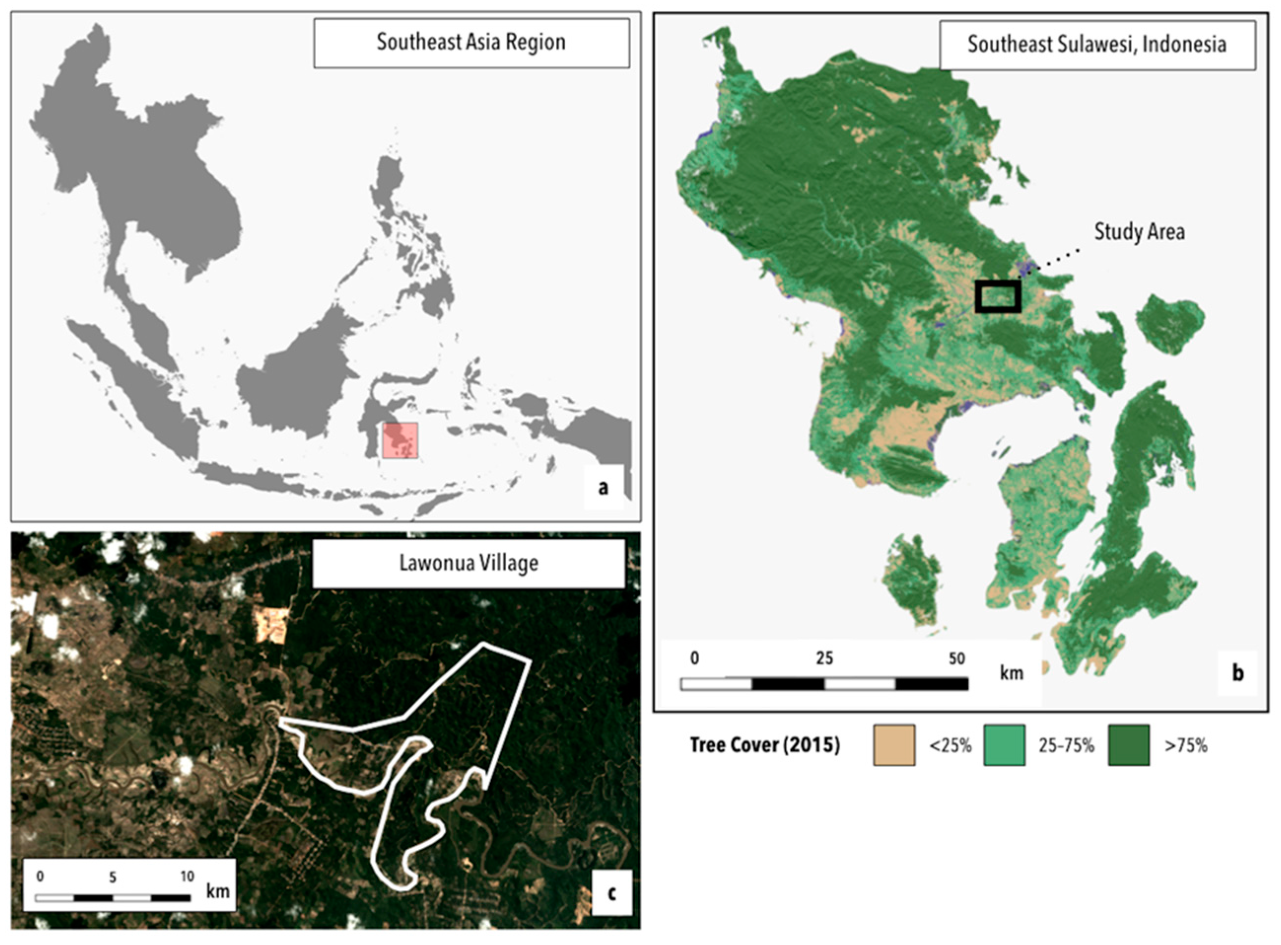
The study village, Lawonua, and surrounding floodplains in Southeast Sulawesi, Indonesia (Figure 1), are characterized by a wet–dry climate and encompass a variety of habitats, including peat swamp, lowland and montane forest, grasslands, and diverse agricultural lands [31,32]. The region is also shaped by the flow of the Konawe’eha River, which stretches from the northwestern reaches of the province into the southwest, flowing from Bulu Brama mountain in the Mekongga mountain range through Kolaka Timur, Konawe Selatan, and Konawe districts. This hydro-climactic and landscape context fosters a wide variety of land and resource use practices, including in Lawonua, where livelihood practices have long been adapted to flood events. Floods typically inundate vegetable cropping lands and swamp lands along the southern border of the village, which is defined by the Konawe’eha River.
The Konawe’eha River routinely overflows its banks, mediated by seasonal trade winds and rainfall dynamics. Between September and March, cooler northwesterly winds pick up moisture crossing the South China Sea between East and West Malaysia, the Philippines, and Vietnam. Humid, southeasterly winds then travel from the West Coast of South Sulawesi, passing the Gulf of Bone and reaching Southeast Sulawesi beginning in late November or early December. Dry southeasterly winds moving north and west from Australia arrive between June and October, shaping the short dry season that exists thereafter. Within this cycle, rainfall to the study area generally peaks between February and July, with river overflow events occurring at the end of the rainy season between May and June [31].
Tolaki people, indigenous to the region, have historically relied on practices of landscape and livelihood mobility tailored to three locally recognized seasons: (i) Wula Oleo (the moon of sun/heat/dryness, from September to November), (ii) Wula Usa (the moon of rain, from April to June), and Wula Bara (the moon of the western wind, from March to April). While rain also falls in other months of the year, rainfall is generally not as heavy during these months as it is throughout the Wulu Usa and Wulu Bara seasons. Within this cycle, highland fields and croplands (I’osu lands) were historically planted with rice and corn at the beginning of the western winds. Following the swidden harvest roughly six months later, people would then descend to the lowlands to plant vegetables in recently flooded lands along the riverbanks (Lalobubuh lands), benefiting from the fertility and ease of cultivation shaped by flood events.
Both I’osu and Lalobubuh lands in the study area are used relationally to buffer resource gaps and diversify production within a single season. Swamps and seasonally inundated lands in and around the Konawe’eha river, for instance, become an abundant fishing ground during the late rainy season and periods of flooding as fish wash up from the overflowing river and are caught using nets, traps, or by hand. Lalobubuh lands are also an important source of sago palms (a subsistence staple processed for the flour of the palm trunk in lean months) and bamboo or swamp timber (such as Longida). I’osu lands are also harvested for various timber and fruit species during the drier season months of vegetable production and cultivation along the riverbanks. Some of these trees were historically planted in swidden plots during fallow periods, while others are harvested from regrown or intact forest.
These livelihood and land use practices, while persistent to some degree, have been considerably reshaped over the past several decades by various forces, including the elaboration of state administrative and bureaucratic capacity in the area, the growth of export-oriented smallholder agricultural production, in-migration, and, since roughly 2010, the demarcation and establishment of roughly 10,000 hectares of industrial oil palm in and around Lawonua village. These developments have not only transformed land use and cover in the study area, converting many previously diverse hillside forests and swidden fallows into the monotypic production of perennial oil palm. They have also altered local hydrology in ways that likely compound flood risk. This is particularly true taken alongside projections of a 2–3% annual increase in precipitation in this region of Indonesia and an anticipated increase in flood frequency and severity due to climate change [4].
Livelihood and land use practices today are characterized by a high degree of heterogeneity. Households own and manage between 1 and 2 hectares of land on average, accessing this land through diverse arrangements: land sharing (bagi tanah), sharecropping (bagi hasil), inheritance, leasing (gadai), and outright sale and purchase. Land use is oriented around the production of key commodity crops, such as cacao, peppercorn, or oil palm, and many households also manage fruit trees (rambutan, durian, banana, and langsat) and cultivate vegetables (including several varieties of corn, pumpkin, green beans, eggplants, and peanuts) for sale or for home consumption. While a prior household survey in 2015 suggests no significant differences in land ownership between indigenous Tolaki people and in-migrants (most of whom are of Buginese ethnicity), there are significant differences in the amount of land managed, with in-migrants managing about one hectare more than Tolaki people on average [33].
Since the introduction of the oil palm concession in 2010, roughly one-third of households in the study area have transferred fallowed forest or agricultural lands to the concession. Many households also have at least one adult member working on the concession. The terms of this work, however, vary considerably. Some individuals, particularly those with close connections to the village government and those who leased more significant land holdings to the concession (i.e., 3–5 hectares), hold salaried positions as full-time workers, security officials, or as foremen. Other individuals, including those hired by foremen for piecemeal labor or those reliant on a daily wage scheme experience considerably less remuneration and employment stability. Management shifts since 2016 have generally made this source of work less attractive, and overall out-migration is considered to have increased since this time.
Roughly half of households in the study area also rely on other sources of off-farm work, including extra-local work at construction sites in nearby cities, such as Una’aha or Kendari. This work is highly differentiated along lines of gender and generation, and in general, it is young men who out-migrate (there are exceptions, however, and occasionally women and whole families out-migrate for work). Increasingly, young men also obtain work on a nearby nickel mining concession, where remuneration is believed to be better than at the more proximate oil palm concession, or in smallholder gold mining sites in Pulau Buru, Ambon. The longer-distance migration of young men, families, and occasional adult women to sites such as Kalimantan, Papua, and Malaysia has also been common since the early 2000s. Such work generally involves waged labor in logging camps or on oil palm plantations (where individuals benefit from slightly higher wages than can be obtained locally).
2.2. Research Approach and Techniques
To understand how individuals experience and respond to flood events in this hydro-climatic and livelihood context, and with what implications for their land use practices, we pursued a mixed-methodological research approach. We began by reconstructing flood histories in Lawonua using focus group discussions and satellite data. We then sought to understand experiences of flood events and land use responses through four months of focused ethnographic research into flooding in the study area (1–2/2019, 4/2019, 6/2019). Ethnographic research into flood events was primarily undertaken by the second author. Insights from this work were also supplemented by long-term work in the study area conducted by the first author (2011–present). Prior work in Lawonua consisted of interviews, oral histories, and household surveys conducted over roughly five weeks in 2011, 2013, and 2018 and roughly six months between 2014 and 2015.
2.2.1. Reconstructing Flood Histories and Associated Landscape Context and Changes
Research into flooding in Lawonua began with three focus group discussions (one with four women living within the floodplains, one with seven women holding agricultural lands by the river, and one with five men with knowledge of flood histories in the village). These discussions sought to establish an understanding of extreme flood events in local terms. For example, respondents were asked about annual or routine flood events and were then asked to differentiate between these events and periods they noted as being more destructive by asking respondents to contrast the extent of land inundated by flood waters and, where possible, to recollect the depth of flood waters and duration of inundation. Discussions also asked respondents to compare flood events to major droughts to situate floods vis-à-vis other climate events in the area. These conversations were used to reconstruct a history of major flood events and helped to catalogue some of the common flood impacts experienced by respondents in the study area.
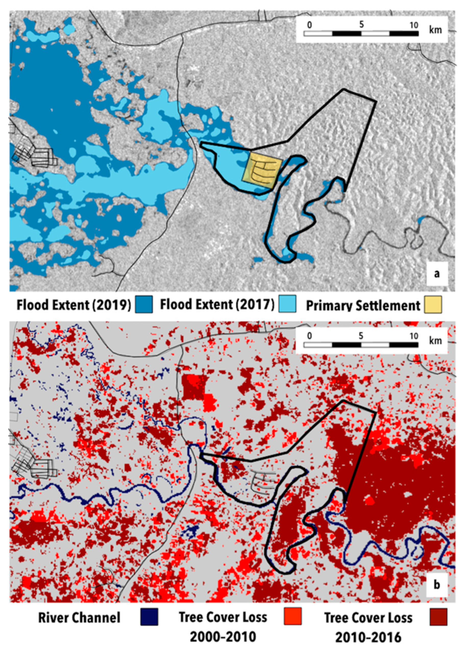
Satellite data were then used to reconstruct the extent of the most recent extreme flood in 2019. Only this year was mapped given limitations in the availability of historical satellite imagery. To compare this event to a “routine” or “typical” river overflow event, we also mapped the 2017 flood. Previous work successfully mapped both repeat inundation and flood events using data from various optical sensors (e.g., Moderate Resolution Imaging Spectroradiometer (MODIS), Landsat, and IKONOS-2a) [34,35,36]. However, such sensors are passive and therefore cannot see through clouds or haze, which are characteristic of large precipitation events that contribute to overbank flooding in Besulutu District. Synthetic aperture radar (SAR), an active remote sensing technology, overcomes this challenge by penetrating clouds and has thus emerged as uniquely well suited for flood mapping [37,38]. The approach we used thus relied on Sentinel-1 C-band radar data (5–40 m, 2014–2019), which were pre-processed for thermal noise removal, radiometric calibration, and terrain correction within Google Earth Engine [39]. Subsequently, threshold-smoothed radar intensities were used to identify inundated areas wherein the flood extent could be mapped by comparing backscatter intensity before the flood event with backscatter intensity at the point of peak flood incidence (dates we obtained from the above discussions). This concept, implemented via code openly accessible within Google Earth Engine, relies on the fact that flat water surfaces typically have a very low backscattering coefficient.
In this study, satellite data obtained courtesy of Planet Labs, Inc. were also used to depict general landscape context in Lawonua and surrounding floodplains (Figure 1c). Landsat data were also used to map the reference river channel and to depict the changes in tree cover increasingly associated with flood events in the study area (a point we return to below). The river channel was mapped by producing a reference image for the year 2015 using cloud masking and image filtering within Google Earth Engine to composite >200 individual Landsat 8 scenes (30 m) from the years 2014–2016 into a gap-free image. This image was subsequently classified using >100 points of water cover to train a random forest “ensemble” classifier (1000 iterations), a learning algorithm that averages across multiple decision trees to ensure relatively unbiased results [40]. Data on tree cover loss from the study by Hansen et al. [41] were also used to depict tree cover loss over two time periods: 2000–2010 and 2010–2016 (i.e., before and after oil palm expansion in the study area). Tree cover loss in the study by Hansen et al. [41] is defined as a state-shift from >25% tree cover to <25% tree cover.
2.2.2. Understanding Smallholder Experiences and Responses to Extreme Flood Events
To understand smallholder experiences and responses to flooding, we primarily relied on in-depth, open-ended interviews. The in-depth interviews began by asking several purposively selected individuals of their recollection of flood events in the village. These individuals were selected by drawing on long-term relationships in the study village, including earlier oral histories and in-depth interviews, during which time village leaders and elders had been identified. Village leaders included not only the village head but heads of neighborhoods within different residential areas. Village elders included those individuals who were considered by many villagers to have the earliest recollections of village events, including some of the first settlers to the village. Discussions with these individuals were helpful in corroborating the initial history of extreme flood events developed during focus group discussions and to understand how past floods related to other key events in village history, including major shifts in land use or control, migration dynamics, or local work opportunities. Several interviews also explored Tolaki cultural practices associated with determining rainy and dry season timing, planting schedules, wind seasons, and fishing and hunting schedules.
Further in-depth, open-ended interviews were then conducted with 24 women and 39 men and with one official at the Regional Disaster Management Agency within Konawe District (Badan Penanggulangan Bencana Daerah Kabupaten Konawe). The first 4–5 respondents were purposively selected using prior knowledge of the study area and by drawing on existing relationships with people living in flood-prone areas or managing lands within the floodplains. From that point forward, a snowball approach was used wherein prior respondents were asked about those individuals in the village who had experienced particular flood impacts or particular responses. The goal throughout was to sample in such a way so as to ensure sufficiently diverse perspectives vis-à-vis relations of class, gender, generation, and ethnicity.
Interviews with selected villagers were used to differentiate our understanding of flood experiences, for example, by asking how the flood had affected their land use and livelihood practices, assets, or social relations and by asking them to describe their life and livelihood circumstances before, during, and after major flood events. In-depth interviews with villagers were also used to understand individual and household land use responses during and following flood events, including the household and individual decision-making processes and access relations (e.g., assets, social relations) informing the specific land use and livelihood strategies adopted. In most cases, interviews were conducted over several visits to respondents’ houses and fields, for instance, to observe land management shifts or see recent damage to crops (as in the case of the 2019 flood). The interview with the official at the Regional Disaster Management Agency, in contrast, sought to understand official perceptions and responses to flooding in the district. Most interviews lasted a minimum of 2 h, and all were open-ended, i.e., conducted without overly structured questions in a way intended to flexibly capture those goals, values, and aspirations shaping respondents’ perceptions and experiences.
3. Results
3.1. Reconstructing Flood Histories
Consistent with the regularity of river overflow events, annual flood events are generally considered to be routine and even positive occurrences in the study area. As one person expressed, “The water improves the land, makes it better, more fertile. Floods aren’t really anything actually, in fact they’re good. What’s hard is drought.” Nearly all respondents, however, agreed that the occasional encroachment of flood waters into residences and road networks has had significantly negative implications for lives and livelihoods. Oral histories help to reconstruct at least six such instances since 1959 (Table 1).
Respondents considered major floods events during these years to have been particularly severe, not only because waters reached lands and settlement areas normally safe from annual floods, but because, depending on the particular event, (i) the waters rose earlier than normal; (ii) the waters rose particularly quickly, inhibiting proactive protection of household goods and property; (iii) lands and settlement areas were inundated for a particularly long period of time, as occurred in 2000 and 2013; and/or (iv) mobility both in and out of the village was disrupted, leading to surging prices for local goods, including rice, sugar, and Liquefied Petroleum Gas (LPG) gas (Table 1). Floods in 2013 and 2019 were also considered to be severe given their coincidence with Eid al-Fitr celebrations. These celebrations are generally a time during which people are highly mobile (visiting family, traveling to and from homes to extra-local work sites) and already cash-strapped given the high costs of holiday preparations.
Figure 2a reconstructs the extent of flood waters for the most recent major flood in Lawonua, that in 2019, contrasting the extent of flood waters with river overflow in 2017 in what was considered to be a more routine inundation event. In 2019, flood waters not only encroached on residential lands but closed off or destroyed critical infrastructure, submerging portions of the clay-mud road network in and out of the village and regional road networks connecting the area to the provincial capital of Kendari and other important sites of work, including the smaller city of Una’aha (Table 1). Information on water depth and flow velocity during these events, as recorded by water gauges or other instrumentation, is limited given the lack of provincial infrastructure for recording such data (the nearest river gauge is one district away). Ethnographic data, however, suggest that flood waters in residential areas reached an average depth of 75 cm, exceeding this in many places (as in those locations where houses were flooded up to rooftops).
Respondents also noted heavy and higher-than-average rainfall anticipating each major flood event. Although rainfall dynamics likely played a role in shaping flood severity, many people also associated extreme floods in 2013 and 2019 with the significant clearance of montane and lowland swamp forest and agricultural fallows for oil palm, which began in 2010 (Figure 2b). Many people believe that the extent of land conversion has amplified the severity of annual flood events by speeding the flow of water from the hillsides into the river and because the river has been directly manipulated to facilitate plantation development. One respondent, for instance, explained that her land on the banks of the river was not historically affected by overflowing waters in the rainy season. Since the oil palm company dug a channel to drain water from the swamp into the river (membuat saluran keluar air dari rawa ke sungai) to facilitate oil palm development on these lands, the river has since flooded most of the surrounding land.
Another respondent with low-lying lands adjacent to the oil palm concession also noted the rapid flow (mengalir kencang) of rainfall from hills planted with oil palm following heavy rainfall. Because people’s croplands are adjacent to the river at the bottom of the hill, waters must pass through their fields before exiting the area if they are not absorbed by the ground. The respondent noted that although the company has made a 10-meter trench (membuat parit ukuran sepuluh meter) in one of the resident’s fields, this has not addressed how quickly waters flow from the hills onto people’s lands. Some respondents also blamed the severity of the 2019 flood on landslides triggered by recent land clearances for oil palm plantings. These landslides, caused by heavy rainfall on the barren lands, blocked river waters at a key upstream passage point, forcing their diversion onto surrounding agricultural lands.
An official at the Regional Disaster Management Agency and official statements following the 2019 flood [43] corroborate villagers’ perceptions. The interviewed district official, for instance, noted that he considers the 2013 flood to have become a disaster provincially—forcing home evacuations, leading to road closures, and eventually causing two deaths—because the areas surrounding the Konawe’eha River had largely been cleared of shrubs, small trees, and other water-absorbing plants in preceding years. This enabled the rapid rise of waters into settlement areas and agricultural lands and inhibited possible response time. In both 2013 and 2019, this official explained that flood impacts were also likely compounded by the breakdown of embankments intended to protect areas surrounding the Konawe’eha River (jebolnya tanggul-tanggul penangkal banjir). Datasets from provincial officials and government ministries suggest that such changes in riparian land cover are now common given an acceleration in large-scale industrial concessions for oil palm, nickel, and asphalt in Konawe district [44,45].
Finally, the severity and frequency of extreme floods post-2000 is explained by some Tolaki respondents in Lawonua as an indication of the loss of indigenous rain management systems. According to such accounts, rainfall in the area has long been regulated by a rain handler (pawang hujan) known as Igone. Igone is seen to have gained an ability to control the rains following a dream-like encounter with religious leaders atop a sacred plateau in the district known as Lalobonda. For years, Igone’s services were used to handle the rain such that ceremonies, plantings, and celebrations could proceed smoothly. While many people continue to believe in Igone’s abilities, they note that he has stopped acting as a rain handler in recent years for unknown reasons.
3.2. Differentiated Smallholder Experiences of Extreme Flood Events
Interviews suggest that extreme flood events in Lawonua have had wide-ranging impacts, not only by directly damaging infrastructure and settlements, but by straining land use and livelihood practices both during and after the onset of flooding. For example, many people noted the difficulty of accessing sufficient food or water during floods. They also noted the ways flood events can disrupt mobility, interrupting access to extra-local work sites (Table 2). These dynamics do not act alone but intensify and broaden the threats people already experience.
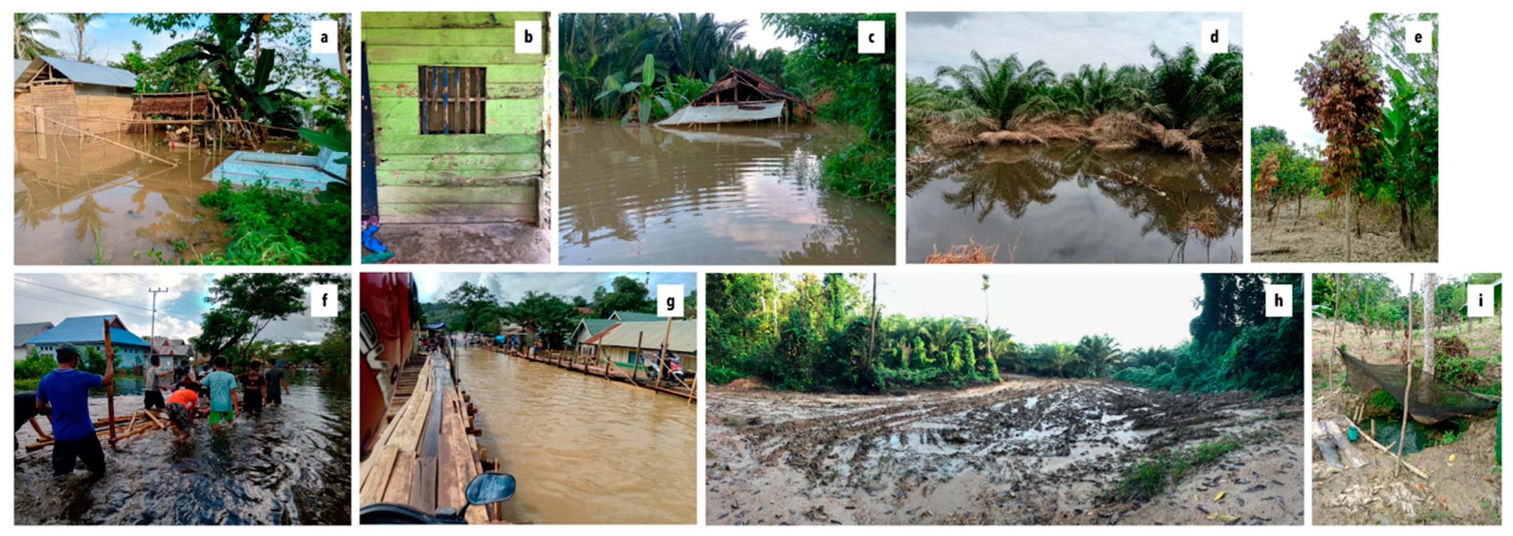
Damage to homes and household property is among the most severe of flood impacts noted and, in some cases, can force the evacuation of homes. In 2019, for instance, there were an estimated 33 houses at least partially inundated by flood waters (Figure 3a). Several families relocated to makeshift tents or the homes of neighbors and kin for 1–2 weeks, and two families moved into village facilities for over a month. Emergency tents made of tarpaulin and bamboo were also used as public kitchens. The intrusion of water into these homes and associated displacements is notable given individuals’ past efforts to relocate their homes out of perceived floodplains, including in the 1980s and again after the major flood of 2000. Flood waters in and around homes not only damage property (including firewood and dried foods and/or home appliances, such as refrigerators, televisions, cabinets, and cookware). They also create various health challenges upon subsequent reoccupation of the home, including respiratory challenges associated with black mold. Stagnant water over a period of weeks also rots walls and wooden foundations, necessitating expensive repairs (Figure 3b).
Direct damage to crops is another key impact experienced by most individuals in the study area, particularly those dependent on riverine vegetable production (Figure 3c). Even where vegetables have been carefully planted to account for the likelihood of flooding in late May and June, they are nonetheless affected when the timing of flood waters cannot be predicted. This was the case in February 2019, for instance, when the early rise of river waters forced a premature harvest of some people’s second peanut, corn, and vegetable crops. These losses were then compounded when a second crop was affected by full land submergence in June 2019. In this case, many lands normally outside the floodplain were also inundated. The result were direct losses in terms of harvest quantities and profits—a scenario that was particularly challenging for those individuals sharecropping lands or who had purchased farm inputs on debt. The persistent rainfall associated with flood events also damages crops (e.g., through fungal outbreaks, rotting, and root damage), thus reducing grower bargaining power for prices.
While damage to seasonal vegetable crops is most common, persistent flood waters can also damage or kill even well-established perennial crops, including important fruit trees such as langsat, rambutan, and durian, and key commodities in the village, including cacao, peppercorn, and increasingly, oil palm (Figure 3d). Damage to such crops is particularly common where seedlings have recently been planted, as was true of many cacao crops in 2000, peppercorn vines in 2013, and replanted cacao seedlings in 2019. Flooding thus often necessitates that smallholders fully replant their fields, relocate production, and/or pursue other livelihood pursuits—prospects associated with foregone income from these lands for as long as 3–4 years. Damage to perennial crops can also drive debt and distress sales of land. Figure 3e also shows damage to a well-established fruit tree inundated by stagnant flood waters for 3–4 days during the 2019 flood. Harvest from these trees is an important source of food and dietary diversity and is often a particularly important source of income for women who typically manage fruit tree harvests.
Beyond damage to houses, household property, and agrarian assets, floods pose a general set of challenges associated with daily production and reproduction, particularly for those individuals reliant on extra-local waged labor to meet daily needs. When flood waters encroach on roads (Figure 3f), people are unable to travel to areas outside the settlement without paying an expensive series of “taxes” (pajak) to transport their motorbikes across inundated portions of the road by raft or makeshift bridges (Figure 3f,g). These taxes can be onerous if work is located far from the village. During the most recent flood, for instance, traveling to the nearby urban area of Una’aha from Lawonua—a common destination for construction work and other casualized forms of work—cost more than 100,000 Rp if accounting for the six flood crossings that needed to be navigated. This cost is double the daily wage for such work. Even within Lawonua, reaching distant agricultural lands or the oil palm concession cost 5000 Rp and required transport by small raft (Figure 3f) over inundated road passages.
In addition to these costs, the unreinforced mud roads that connect the village to the concession and to provincial road networks are often too dangerous to be traveled by motorbike, becoming nearly unpassable even where not fully inundated (Figure 3h). Occasional landslides triggered by heavy rainfall also block road access, as was true in 2013. In many cases, the roads become so difficult to travel during periods of flooding and heavy rainfall that even the heavy, high-raised trucks that regularly carry workers to and from the concession stop operating (thus cutting off work for day laborers or people paid piecemeal wages). As one respondent noted during the 2019 flood:
The drivers aren’t brave, the road as slippery as it is now. The risk is high, and there’s no guarantee [compensation for losses] from the company if there’s a work accident. There is only tolerance [for missed work], but even that is not guaranteed to everyone.
These fears were accentuated in 2017 after an accident that resulted in the death of 14 people. Now, even when drivers are willing to transport workers to the concession, people are often too afraid to travel by truck until road conditions stabilize. This impact is felt most closely by casualized day laborers on the concession; individuals in staff positions receive stable wages despite missing work during flood events.
Finally, many individuals also experience challenges accessing sufficient food and water. This is particularly true of those individuals already indebted to local traders, individuals that are older or infirm and unable to fish within flooded lands, or individuals without access to reliable social networks that can guarantee access to food or water entitlements during floods. Many people report replacing most food needs with bananas during flood events and occasionally, sago flour—a staple food common in the area and cheaper than rice. Almost all people also face challenges accessing sufficient vegetables during and after floods. Floods not only disrupt local vegetable supplies by killing vegetables along riverbanks but, in so doing, significantly raise the price of vegetables sold at markets and by local traders. Challenges accessing sufficient food are also shaped by road conditions, which inhibit the movement of traders into the village. Village kiosks often run out of dried food goods quickly, including rice and dried noodles, and road conditions further impede independent travel to markets.
Given that many households access water from dug wells rather than boreholes (which can cost over $500 USD to install), many individuals also face challenges accessing clean, safe water for drinking or home consumption during and after floods. In one neighborhood of the village, for instance, only two dug wells remained accessible for accessing clean water during the 2019 flood (Figure 3i). The water in the remaining dug wells was contaminated with flood waters carrying dead animals (e.g., mice, rats), disease, agri-chemical pollutants picked up from nearby fields, and mud, silt, and other debris. Challenges accessing water of sufficiently high quality also reflects agri-chemical contamination from swamp lands converted into oil palm land. Many respondents believe that this explains why the fish and eels caught on flooded lands were in weak condition in 2019, seemingly rotting before being caught.
Before examining responses, it is important to note the socially differentiated ways floods are experienced. Experiences of property damage, for instance, as well as damage to crops and gaps in mobility and food and water availability, tend to hit the poorest individuals the hardest. Relatively wealthier individuals and households can afford residential lands outside floodplains and borewells protected from flood water contamination; flood damages also comprise a lower proportion of their total income and assets. Such households are also more likely to have members holding salaried work immune from wage gaps during periods of lost work and/or savings they can tap into to service regular debt payments or the elevated costs of mobility during flood periods. All of these conditions translate into a relatively higher capacity to cope with the worst impacts of flooding, enabling such individuals, for example, to purchase vegetables and other dried food goods. Alternatively, those individuals and households dependent on debt for basic needs often even lack access to debt during floods.
Gendered and generational relations intersect with these access relations to shape flood impacts. Gender alone does not predict vulnerability to flooding but can exacerbate existing strains, particularly in poorer households or in households where few male members remain due to high male out-migration. This is particularly true given gendered divisions of labor in the study area; the burden of finding new water and food sources often falls disproportionately on women. The same can be said of ethnicity and social connections, which shape the terms of access to common property resources, livelihood opportunities, support from extended family members, and access to support in relocating belongings, preparing crops for an early harvest, etc. Coping with strained food needs by relying on swamp fish and sago palms, for instance, can be inaccessible or culturally unfamiliar for in-migrants not accustomed to these food sources. As one Buginese woman explained, describing her family’s reliance on sago flour when local stores ran out of rice:
I tried to buy sago flour. Even though we Bugis people don’t usually eat sago flour, and don’t feel full when we do. But what’s to be done? There’s only that to eat at the time of the floods so that’s what I gave to my children to eat.
Despite the significance of flood experiences and impacts in the study area, however, and the likelihood that such events may reinforce existing disparities, we were able to uncover very few institutionalized responses to extreme floods. Rather, most actions taken in anticipation of flood events are individualized or undertaken alongside neighbors and close kin (e.g., early harvest of crops, relocation of belongings out of the floodplain and into makeshift tents or structures, accumulation of food reserves). In other words, in the absence of strong institutional responses—whether extra-local or community—most responses to flooding are individualized. We found evidence of two exceptions to this: a company-level response in 2013, during which affected households were given several packs of dried noodles and some toiletries, and a government response in 2019 that involved limited food goods for displaced households and the establishment of a local evacuation shelter in unused village facilities.
3.3. Responses and Alterations in Land Use Practices
This section documents the land use strategies that respondents use to respond to floods, as well as to anticipate and avoid future flood impacts. While fully examining the range of dynamics shaping these land use responses is outside the scope of this study, it is important to note that floods are far from the only challenge individuals confront in the study area. As is true in all smallholder farming systems [46], a range of other dynamics also inform land use practices, including price collapses for major commodities, pest and pathogen outbreak, social conflict, illness, and countervalent climatic dynamics. Thus, the land use changes we note below—while noted by respondents as a means of responding to the flood impacts described above, particularly damage to crops and productive agrarian assets—are impossible to explain solely in terms of flooding.
3.3.1. Relocating Vegetable Production from Riverbank to Hillside Lands
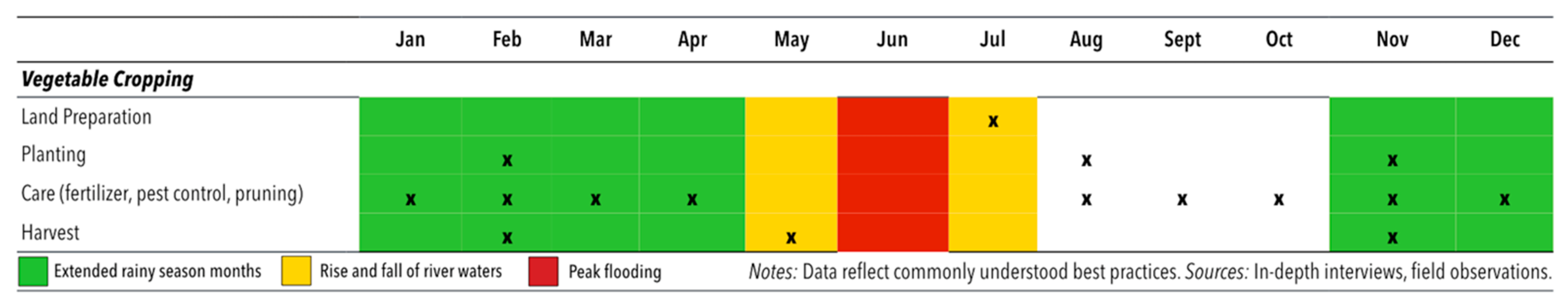
Tolaki people that still farm in accordance with tidal flows make the seasonal ebb and flow of the river their key signal for 2–3 vegetable cropping cycles annually (Figure 4). Yet, many individuals, particularly older individuals, noted that seasonal flooding has become more difficult to predict since roughly 2000 (banjir semakin tidak menentu). The difficulty of predicting seasonal flooding cycles, in turn, implies a higher risk of crop failure or damage due to early flooding or late plantings. Crop damage due to early flooding occurred twice in 2019, first with the early surge of flood waters in February and second with the more substantial flood event in June, as people attempted to belatedly replant lands that had been flooded in February. In some cases, late flooding also pushes initial plantings from August into September or October. Planting in these months, the driest of the year, carries the risk of crop failure due to stunting.
Our interviews suggest that one way individuals are adapting to this unpredictability is by developing vegetable lands in the hills (or I’osu lands). One interviewed respondent had just finished clearing land owned by her son on the day she was interviewed, opening these lands for eggplant, pumpkin, green beans, cassava leaves, and yellow corn. “People around here, Tolaki people, we usually plant vegetables at the edge of the river, not on the mountain”, she stated, acknowledging that the practice was still relatively foreign (asing) among Tolaki people given the higher incidence of rat, monkey, and pig pests on hillside lands. She predicts, however, that when the rainy season hits, she will be able to sell crops from the hillside, thus capitalizing on high prices for vegetables during flood months. On previously borrowed lands in 2017, for instance, she made nearly 750,000 Rp (~$50 USD) from an eggplant crop when seasonal floods inundated riverside lands. During this time, the price of eggplants reached 150,000 Rp per sack (in contrast with its regular price of roughly 40,000 Rp per sack).
Another respondent, an older Buginese man, had also just opened two hectares of hillside land for chili peppers at the time of this study (a vegetable crop with particularly good market prices at present). To do so, he converted two hectares of lands previously planted with cacao and peppercorn. To safeguard chili pepper production from the corresponding challenges of drought (arguably challenges that are amplified when producing vegetables far from the riverbank), he has prepared a water reservoir using plastic sheeting. He now draws water from the river using a water pump (mesin pompa air) and uses the makeshift water reservoir to irrigate his crop during the dry season months of August, September, and October. This individual has also prepared raised beds (15–20 cm) to maintain soil moisture for the weak roots of the young chili plants as they are established. Notably, this response requires not only access to land but substantial capital, including capital for hired labor to rapidly establish a seasonal crop.
3.3.2. Transferring Lands within the Floodplains to Other Claimants/Operators
In response to flood damages, other respondents have either chosen or been forced to sell, lease, or sharecrop those lands along the river most susceptible to flood exposure. These transactions reflect a longstanding response to flooding in the study area. For instance, many Buginese households first arriving in the village in 1997 purchased lands along the river believing these lands to be best suited for cacao production, given their proximity to water. Shortly after planting these lands, however, many young cacao seedlings were killed when inundated for roughly a month during the extreme flood event of 2000. Rather than replant, many people simply relocated out of the floodplain at this time, also relocating the small houses installed in their fields (rumah kebun). To some extent, these transactions mirror the reallocation of labor to hillside lands; occasionally individuals sell or lease riverbank lands specifically because they are opting to invest greater labor in other livelihood or land use pursuits.
Since the flood of 2000, between 10 and 15 households in the study area have also rented riverside lands to small sand mining operations, which dredge sand from the bottom of the river. These operations can start and stop their operations seasonally, insulating mining equipment from damage due to flooding. Sand mining activities in the village have also grown following the flood of 2013 and in response to the concession’s presence (in part, it seems, because the concession creates a local market for concrete). In a typical sand mining operation, formerly cultivated or fallowed lands along the riverbank are leased by the intended sand mining operator, who secures the associated supplies and necessary permits. A pumping machine on a floating platform established in the middle of the river is then used to dredge sand from the riverbed through a series of Polyvinyl Chloride (PVC) tubes and into a large circular tub (bak) installed on the lands proximate the river. Subsequently, the sand can be sold locally or shoveled into large trucks (ret) for transport to nearby markets.
Increasingly, many households are also leasing previously cultivated lands along the riverbank to the oil palm company under a 35-year leasing scheme. This leasing scheme is accompanied by an 80–20 benefit sharing scheme that is irrespective of the specific lands entered into the concession (i.e., all households or individuals transferring land to the company receive an equal share of the benefits upon harvest). The major floods in 2000 and 2013 were a major motivation for these transactions according to many respondents. Some respondents explained that land leasing for oil palm is attractive because the company bears all risk of loss on these lands (indeed, oil palm has been replanted twice on many riverbank lands since it was first established in these locations due to damage from flooding). A number of individuals are also selling fallowed lands in the swamp to the oil palm company for these reasons. To protect against submergence on these lands, the company is dredging the land and making 1–3-m hills for each tree.
3.3.3. Adapting Land Management and Resource Use Practices
Smallholders have also altered their planting practices within seasonally inundated lands to manage and mitigate potential flood risks. Some individuals, for instance, note that they are now more hesitant to plant prior to flood months, instead planting immediately after flood waters have receded. This ensures the at least two cropping periods prior to flood months and three if individuals are willing to risk the early onset of floods damaging their second or third crop (see Figure 4). Given the general vegetable shortage when the lands around the Konawe’eha River are flooded, many growers also race to plant their lands (petani belomba cepat-cepatan untuk menanam di lahan mereka) following the recession of waters (sesaat setelah air surut) to exploit not only renewed fertility but to get in on markets while prices remain high. As one respondent noted:
If you are forced to plant three times in a year [by need], and you happen to be late in first planting, just wait. If you’re lucky you’ll be safe, but if the third crop doesn’t finish in time, the crop is flooded.
In making these decisions, individuals also must account for a range of other climate and market considerations. Many respondents, for instance, believe that intense droughts between August and October are particularly common following extreme floods and see very early vegetable plantings as a way to safeguard crops from this likelihood (though there remains a potential that the lands will subsequently be flooded again). A growing number of individuals are also purchasing water pumps to insulate against this possibility and enable vegetable cropping even during the driest months of the year. This trend capitalizes on the introduction of electricity in the village in 2015. Those individuals that cannot afford to invest in water pumps (which can cost between $100–300 USD) will also sometimes use drip bottles to ensure young seedlings continue to grow in the months immediately following flooding.
Some respondents also note alterations in their vegetable cropping choices in response to more severe flood impacts and the market opportunities flooding creates. One respondent, for instance, noted that because so many individuals plant peanuts following the floods for ease of cultivation, she has instead chosen to intercrop corn with pumpkin and eggplants (thus capitalizing on higher prices for these crops). Decisions such as these are also undertaken alongside other shifts in land management, including early harvest and land preparation. These latter strategies are undertaken prior to floods to protect vegetable crops planted along the riverbank. For instance, many respondents accelerate their harvest when they see flood waters rise, opting for partial profits or crops rather than full loss even if the submergence of land is not guaranteed. Others apply herbicide and clear land in anticipation of land submergence to ensure lands can be immediately planted following the recession of waters (i.e., without even the delays associated with land clean-up or clearance).
Finally, whether or not individuals continue to cultivate vegetables on riverbank lands, nearly all households depend on common property resources along the river (in particular, swamp forests and wetlands) for fish resources, bamboo, and occasional timber needs during and after flood events. While access to forests and swamps in the area is increasingly strained due to land conversions for oil palm, forest vegetables are still occasionally harvested as a short-term food source during particularly challenging times. We found that nearly all the interviewed respondents depend on fishing in swamp lands and flooded lands to meet their food needs during floods, fishing using trawls, traps, and fishing rods and sometimes harvesting enough to dry and salt fish for later needs. Though riverbank lands outside the swamp are typically owned and managed under individualized property regimes, flooded lands can generally be accessed as a common property resource during this time, provided individuals abide by several key rules: that they do not fish with poison or dynamite and that they do not take more than fulfills household needs.
4. Discussion and Conclusions
Though flooding is a routine occurrence throughout much of the monsoonal tropics, extreme flood events necessitate a range of short- and long-term adaptive responses to cope with existing challenges and prepare for the future. This study explores these changes with a focus on how people in a particularly flood-prone village along the Konawe’eha River in Southeast Sulawesi experience floods and on how they modify their land use practices in response. It builds on a growing literature about how smallholders experience and respond to climate extremes.
We find that although people in this area have long adapted to seasonal flood events, extreme floods considerably disrupt lives and livelihoods in a context of high natural resource dependence. The key challenges documented here include direct damage to crops, property, and village and provincial infrastructure. Indirect damage includes that associated with prolonged and heavy rainfall, such as secondary landslides and damage to crops from altered pest and pathogen regimes. Vulnerability to such impacts is informed not only by villagers’ lack of access to institutional support, e.g., from government agencies or officials, it is also informed by pre-existing differences that render some individuals particularly susceptible to flood impacts (including relative location within the floodplains and differentiated access to capital and social connections). Resonant of the notion of “double exposure” [1], systemic vulnerability to flooding in the study village appears to have increased with the development of industrial oil palm from 2010 to present.
In this context, smallholders employ their land use practices as a key site of adaptation to floods. The adaptations noted in this study include a reorientation of riverine vegetable production to hillside locations and the sale or leasing of lands along the riverbank to more industrialized land use operations. Smallholder land use adaptations also include enhanced dependence on common property resources and an intensification of vegetable production on riverbank lands outside primary flooding months. This latter trend appears to be facilitated by the adoption of water pumping machines and by strategic applications of agri-chemicals prior to the onset of floods. Future research could build on these findings by exploring the extent to which these responses are contributing to land use and cover change in the study area, including through the development of more refined satellite analyses of vegetative change. Future research could also build on this study by more deeply exploring the socio-spatial correlates of flooding experiences and observed adaptive responses.
Even in the absence of these insights, however, findings appear to reiterate the notion that smallholder responses to flood events rarely reflect a simple “bouncing back” to a prior, pre-flood state. Rather, they set in motion processes productive of their own transformations [6,27]. In this regard, one finding deserving of further study in the research area is the possibility that land transfers into sand mining and oil palm operations on riverbank lands may be increasing systemic vulnerability to flood events. Smallholders have already linked the oil palm concession to amplified flood risk due to its role in accelerating water run-off into the river and enabling subsidiary landslides, which block river flow. Sand mining also alters river morphology, altering river flow, eroding riverbanks, and heightening sediment load in the water with trickle-down implications for local fish and wildlife populations. How and in what ways do these dynamics increase the likelihood and/or severity of flood events, particularly alongside ongoing climate change?
Further research is required to understand the intersecting considerations shaping apparent land–livelihood dynamics during and after flood events. A growing body of work, for instance, shows that climate stressors are rarely the sole driver of livelihood changes, with issues such as political economy, property rights, and access to assets often playing a more central role [14,46,47,48]. These intersecting dynamics, however, were only peripherally addressed by this study. Future work could also more directly examine the dynamics of “double exposure” [1] posed by the simultaneity of the concession and climate change in the study area, including the role of these simultaneous dynamics in contributing to land use change throughout the region. This is particularly important as industrial development may be reducing access to the common property resources that buffer food needs during challenging times while simultaneously altering local hydrology and livelihood profiles. Finally, further information on the quantitative features of extreme flood events (e.g., average water depth and flow velocity) could enhance ethnographic information by enabling a deeper understanding of the relationship between these variables and flood experiences.
Author Contributions
Conceptualization, L.C.K; methodology, L.C.K. and A.P.; formal analysis, L.C.K.; investigation, A.P.; resources, writing—original draft preparation, L.C.K.; writing—review and editing, A.P.
Funding
This research was supported by a Research Support Award from the College of Social Sciences at the University of Hawai’i-Mãnoa.
Acknowledgments
We thank the individuals and institutions in Indonesia whose support and time made this research possible.
Conflicts of Interest
The authors declare no conflicts of interest.
References
- Leichenko, R.; O’Brien, K. Environmental Change and Globalization: Double Exposures; Oxford University Press: New York, NY, USA, 2008. [Google Scholar]
- Borras, S.M.; Franco, J.F. Political Dynamics of Land Grabbing in Southeast Asia; Transnational Institute: Amsterdam, The Netherlands, 2011. [Google Scholar]
- Radel, C.; Schmook, B.; Carte, L.; Mardero, S. Toward a Political Ecology of Migration: Land, Labor Migration, and Climate Change in Northwestern Nicaragua. World Dev. 2018, 108, 263–273. [Google Scholar] [CrossRef]
- Hirabayashi, Y.; Mahendran, R.; Koirala, S.; Konoshima, L.; Yamazaki, D.; Watanabe, S.; Kim, H.; Kanae, S. Global flood risk under climate change. Nat. Clim. Chang. 2013, 3, 816. [Google Scholar] [CrossRef]
- Seneviratne, S.I.; Nicholls, N.; Easterling, D.; Goodess, C.M.; Kanae, S.; Kossin, J.; Luo, Y.; Marengo, J.; Mc Innes, K.; Rahimi, M.; et al. Changes in climate extremes and their impacts on the natural physical environment: An overview of the IPCC SREX report. In Managing the Risks of Extreme Events and Disasters to Advance Climate Change Adaptation; Cambridge University Press: Cambridge, UK, 2012; Volume 14, p. 12566. [Google Scholar]
- Middleton, C.; Elmhirst, R.; Chantavanich, S. Living with Floods in a Mobile Southeast Asia: A Political Ecology of Vulnerability, Migration and Environmental Change; Routledge: Abingdon, UK, 2017. [Google Scholar]
- Salamanca, A.; Soukkhy, O.; Rigg, J.; Ernerot, J. Risky spaces, vulnerable households, and mobile lives in Laos: Quo vadis flooding and migration? In Living with Floods in a Mobile Southeast Asia; Routledge: Abingdon, UK, 2017; Available online: https://www.taylorfrancis.com/ (accessed on 10 March 2019).
- Thabchumpon, N.; Arunotai, N.; Arunotai, N. Living with and against floods in Bangkok and Thailand’s central plain. In Living with Floods in a Mobile Southeast Asia; Routledge: Abingdon, UK, 2017; Available online: https://www.taylorfrancis.com/ (accessed on 10 March 2019).
- Ward, P.J.; Jongman, B.; Salamon, P.; Simpson, A.; Bates, P.; De Groeve, T.; Muis, S.; De Perez, E.C.; Rudari, R.; Trigg, M.A.; et al. Usefulness and limitations of global flood risk models. Nat. Clim. Chang. 2015, 5, 712–715. [Google Scholar] [CrossRef]
- Brémond, P.; Grelot, F.; Agenais, A.-L. Review Article: Economic evaluation of flood damage to agriculture—Review and analysis of existing methods. Nat. Hazards Earth Syst. Sci. 2013, 13, 2493–2512. [Google Scholar] [CrossRef]
- Molinari, D.; Scorzini, A.R.; Gallazzi, A.; Ballio, F. AGRIDE-c, a conceptual model for the estimation of flood damage to crops: Development and implementation. Nat. Hazards Earth Syst. Sci. Discuss. 2019, 1–24. [Google Scholar] [CrossRef]
- Lyle, G. Understanding the nested, multi-scale, spatial and hierarchical nature of future climate change adaptation decision making in agricultural regions: A narrative literature review. J. Rural Stud. 2015, 37, 38–49. [Google Scholar] [CrossRef]
- Morton, J.F. The impact of climate change on smallholder and subsistence agriculture. Proc. Natl. Acad. Sci. USA 2007, 104, 19680–19685. [Google Scholar] [CrossRef] [Green Version]
- Wise, R.M.; Fazey, I.; Smith, M.S.; Park, S.E.; Eakin, H.C.; Van Garderen, E.A.; Campbell, B. Reconceptualising adaptation to climate change as part of pathways of change and response. Glob. Environ. Chang. 2014, 28, 325–336. [Google Scholar] [CrossRef] [Green Version]
- Mortreux, C.; Barnett, J. Adaptive capacity: Exploring the research frontier. Wiley Interdiscip. Rev. Clim. Chang. 2017, 8, e467. [Google Scholar] [CrossRef]
- Wood, S.A.; Jina, A.S.; Jain, M.; Kristjanson, P.; DeFries, R.S. Smallholder farmer cropping decisions related to climate variability across multiple regions. Glob. Environ. Chang. 2014, 25, 163–172. [Google Scholar] [CrossRef] [Green Version]
- McDowell, J.Z.; Hess, J.J. Accessing adaptation: Multiple stressors on livelihoods in the Bolivian highlands under a changing climate. Glob. Environ. Chang. 2012, 22, 342–352. [Google Scholar] [CrossRef]
- Adger, W.N.; Vincent, K. Uncertainty in adaptive capacity. Comptes Rendus Geosci. 2005, 337, 399–410. [Google Scholar] [CrossRef]
- Bassett, T.J.; Fogelman, C. Déjà vu or something new? The adaptation concept in the climate change literature. Geoforum 2013, 48, 42–53. [Google Scholar] [CrossRef]
- Bacon, C.M.; Sundstrom, W.A.; Stewart, I.T.; Beezer, D. Vulnerability to Cumulative Hazards: Coping with the Coffee Leaf Rust Outbreak, Drought, and Food Insecurity in Nicaragua. World Dev. 2017, 93, 136–152. [Google Scholar] [CrossRef]
- Belliveau, S.; Smit, B.; Bradshaw, B. Multiple exposures and dynamic vulnerability: Evidence from the grape industry in the Okanagan Valley, Canada. Glob. Environ. Chang. 2006, 16, 364–378. [Google Scholar] [CrossRef]
- Wells, J.A.; Wilson, K.A.; Abram, N.K.; Nunn, M.; Gaveau, D.L.; Runting, R.K.; Tarniati, N.; Mengersen, K.L.; Meijaard, E. Rising floodwaters: Mapping impacts and perceptions of flooding in Indonesian Borneo. Environ. Res. Lett. 2016, 11, 064016. [Google Scholar] [CrossRef]
- UNISDR. Global Assessment Report on Disaster Risk Reduction; United Nations International Strategy for Disaster Reduction: Geneva, Switzerland, 2011. [Google Scholar]
- Blaikie, P.; Cannon, T.; Davis, I.; Wisner, B. At Risk: Natural Hazards, People’s Vulnerability, and Disasters; Routledge: Abingdon, UK, 1994. [Google Scholar]
- Middleton, C.; Un, B. Living with the flood: A political ecology of fishing, farming, and migration around Tonle Sap Lake, Cambodia. In Living with Floods in a Mobile Southeast Asia; Routledge: Abingdon, UK, 2017; Available online: https://www.taylorfrancis.com/ (accessed on 10 March 2019).
- Ziegler, A.D.; Bruun, T.D.; Guardiola-Claramonte, M.; Giambelluca, T.W.; Lawrence, D.; Lam, N.T. Environmental Consequences of the Demise in Swidden Cultivation in Montane Mainland Southeast Asia: Hydrology and Geomorphology. 2009. Available online: https://link-springer-com.eres.library.manoa.hawaii.edu/article/10.1007/s10745-009-9258-x (accessed on 20 August 2019).
- Betteridge, B.; Webber, S. Everyday resilience, reworking, and resistance in North Jakarta’s kampungs. Environ. Plan. E Nat. Space 2019. [Google Scholar] [CrossRef]
- Jain, M.; Naeem, S.; Orlove, B.; Modi, V.; DeFries, R.S. Understanding the causes and consequences of differential decision-making in adaptation research: Adapting to a delayed monsoon onset in Gujarat, India. Glob. Environ. Chang. 2015, 31, 98–109. [Google Scholar] [CrossRef]
- Forsyth, T.; Evans, N. What is Autonomous Adaption? Resource Scarcity and Smallholder Agency in Thailand. World Dev. 2013, 43, 56–66. [Google Scholar] [CrossRef] [Green Version]
- Bryant, R.L.; Bailey, S. Third World Political Ecology; Psychology Press: Hove, UK, 1997. [Google Scholar]
- Whitten, T.; Henderson, G.S. Ecology of Sulawesi; Tuttle Publishing: Clarendon, VT, USA, 2012. [Google Scholar]
- Kelley, L.C.; Evans, S.G.; Potts, M.D. Richer histories for more relevant policies: 42 years of tree cover loss and gain in Southeast Sulawesi, Indonesia. Glob. Chang. Biol. 2017, 23, 830–839. [Google Scholar] [CrossRef]
- Kelley, L.C. The politics of uneven smallholder cacao expansion: A critical physical geography of agricultural transformation in Southeast Sulawesi, Indonesia. Geoforum 2018, 97, 22–34. [Google Scholar] [CrossRef]
- Allen, G.H.; Pavelsky, T.M. Global extent of rivers and streams. Science 2018, 361, 585–588. [Google Scholar] [CrossRef] [PubMed] [Green Version]
- Huang, C.; Chen, Y.; Wu, J. Mapping spatio-temporal flood inundation dynamics at large river basin scale using time-series flow data and MODIS imagery. Int. J. Appl. Earth Obs. Geoinformation 2014, 26, 350–362. [Google Scholar] [CrossRef]
- Pekel, J.-F.; Cottam, A.; Gorelick, N.; Belward, A.S. High-resolution mapping of global surface water and its long-term changes. Nature 2016, 540, 418. [Google Scholar] [CrossRef] [PubMed]
- Martinis, S.; Kuenzer, C.; Wendleder, A.; Huth, J.; Twele, A.; Roth, A.; Dech, S. Comparing four operational SAR-based water and flood detection approaches. Int. J. Remote Sens. 2015, 36, 3519–3543. [Google Scholar] [CrossRef]
- Twele, A.; Cao, W.; Plank, S.; Martinis, S. Sentinel-1-based flood mapping: A fully automated processing chain. Int. J. Remote Sens. 2016, 37, 2990–3004. [Google Scholar] [CrossRef]
- Google Earth Engine. Sentinel-1 Algorithms. 2019. Available online: https://developers.google.com/earth-engine/sentinel1#metadata-and-filtering (accessed on 19 August 2019).
- Belgiu, M.; Drăguţ, L. Random forest in remote sensing: A review of applications and future directions. ISPRS J. Photogramm. Remote Sens. 2016, 114, 24–31. [Google Scholar] [CrossRef]
- Hansen, M.C.; Potapov, P.V.; Moore, R.; Hancher, M.; Turubanova, S.A.; Tyukavina, A.; Thau, D.; Stehman, S.V.; Goetz, S.J.; Loveland, T.R.; et al. High-resolution global maps of 21st-century forest cover change. Science 2013, 342, 850–853. [Google Scholar] [CrossRef]
- Kumparan. Lagi, Dua Pengungsi Banjir di Kabupaten Konawe Meninggal Dunia. 2019. Available online: https://kumparan.com/kendarinesia/lagi-dua-pengungsi-banjir-di-kabupaten-konawe-meninggal-dunia-1rHpLWrAmfX (accessed on 15 June 2019).
- Kamarudin. Lingkungan Rusak Picu Bencana di Sulawesi Tenggara. Mongabay Environmental News. 2019. Available online: https://www.mongabay.co.id/2019/06/24/lingkungan-rusak-picu-bencana-di-sulawesi-tenggara/ (accessed on 5 September 2019).
- Direktorat Jenderal Perkebunan. Luas Areal dan Produksi Perkebunan Rakyat Tanaman Tahunan Provinsi Sulawesi Tenggara Tahun 2013; Direktorat Jenderal Perkebunan: Jawa Barat, Indonesia, 2013. [Google Scholar]
- World Resources Institute. Global Forest Watch. Land Use, Counry-Specific Data, Commodities. 2019. Available online: https://www.globalforestwatch.org (accessed on 25 September 2018).
- Nyantakyi-Frimpong, H.; Bezner-Kerr, R. The relative importance of climate change in the context of multiple stressors in semi-arid Ghana. Glob. Environ. Chang. 2015, 32, 40–56. [Google Scholar] [CrossRef]
- Burnham, M.; Ma, Z. Multi-Scalar Pathways to Smallholder Adaptation. World Dev. 2018, 108, 249–262. [Google Scholar] [CrossRef]
- Eakin, H.; Winkels, A.; Sendzimir, J. Nested vulnerability: Exploring cross-scale linkages and vulnerability teleconnections in Mexican and Vietnamese coffee systems. Environ. Sci. Policy 2009, 12, 398–412. [Google Scholar] [CrossRef]
Figure 1.
(a,b) The study area in regional and provincial context; (c) The study village in landscape context, imagery courtesy of Planet Labs, Inc.
Figure 1.
(a,b) The study area in regional and provincial context; (c) The study village in landscape context, imagery courtesy of Planet Labs, Inc.

Figure 2.
(a) Flood extent during extreme (2019) and more routine (2017) flooding years, as captured by Sentinel C-radar data; (b) Tree cover loss in the study area before and after the 2010 establishment of the oil palm concession.
Figure 2.
(a) Flood extent during extreme (2019) and more routine (2017) flooding years, as captured by Sentinel C-radar data; (b) Tree cover loss in the study area before and after the 2010 establishment of the oil palm concession.

Figure 3.
(a) A partially inundated home and adjacent firewood reserves and family graves; (b) rot to the lower baseboards of a home from an earlier flood in 2013; (c) submerged vegetable lands and temporary farm shelter for rest and harvest; (d) submerged oil palm plantings beginning to rot from the bottom up; (e) a fruit tree with considerable leaf loss and in the early stages of death after submergence for 3–4 days; (f) a raft being used to transport motorbikes across inundated portions of the village road network; (g) a makeshift bridge built on provincial road networks to facilitate mobility; (h) the state of village roads during normal rainy season conditions, when mud can make the roads nearly impassable; and (i) one of two remaining dug wells accessible for drinking water in the study area after flood waters contaminated the other dug wells.

Figure 4.
Vegetable planting calendar in riverbank lands.


Table 1.
Extreme flood events in the study area.
| Year | Description |
|---|---|
| 1959 | This flood, considered by respondents to be one of the most severe in living memory, caused the collapse of a major iron and wooden bridge built during Japanese occupation (1942–1945), connecting inland regions to the capital city of Kendari. People managing lands in and around Lawonua during this time recounted water covering many agricultural fields and much of the land that subsequently became the site of a resettlement scheme in 1979. |
| 1978 | Flood waters this year extended well beyond the agricultural lands surrounding the river and inundated significant portions of the main road connecting inland regions to Kendari. The impacts of this flood in more established settlements also motivated the resettlement scheme in Lawonua in 1979 that provided 100 families with access to land and housing in Lawonua, ostensibly in areas outside the reach of flood waters. |
| 2000 | Flooding in 2000 lasted roughly a month, completely closing all but one access path in and out of the village to the main road to Kendari. The impacts of this flood were particularly felt by recent in-migrants into the area, who struggled to access sufficient food, including rice, and who had recently planted perennial crops in riverbank lands. |
| 2013 | Flooding in 2013 lasted nearly three months (June–September), with peak flooding persisting for roughly a month and inundating portions of the road to Kendari. Roughly 15 houses in Lawonua were inundated to chest height, and landslides triggered by heavy rainfall blocked access along one of roads out of the village and affected several household hillside fields. Two deaths from the flood were recorded in the province. |
| 2019 | The inundation of agricultural lands and settlements was of much shorter duration in 2019 than had been the case in 2000 or 2013, but most respondents noted that the waters rose much more quickly than was the case in either of these prior flood events. Flood waters began to rise on June 9, before peaking on June 11 and beginning to recede around June 25. Overall, 33 houses were inundated to some degree in Lawonua during this flood. As with other major floods, mobility was disrupted on both local roads and provincial road networks. Several deaths were recorded from this flood [42]. |
Given the nature of historical recall, more precise estimates of flood timing and duration is possible only for recent floods. Where estimates were only substantiated by 1–2 respondents, they are not reported. For instance, one respondent recalled a major flood in 1952, but we have not yet been able to corroborate this through other interviews. In general, identifying floods prior to 1979 proved difficult given that many individuals used the village for agricultural land rather than permanent settlement prior to this point.
Table 2.
Key flood impacts.
| Impact | Summary |
|---|---|
| Damage to house or household property | Permanent damage to homes and household items (e.g., cabinets, televisions, mattresses, firewood) |
| Damage to infrastructure | Permanent damage to bridges, dykes, roads, health facilities |
| Damage to crops | Rotting due to water damage, change in pest/pathogen regime, full loss of crop |
| Challenges accessing clean water | Infiltration of muddy or polluted flood waters into dug wells |
| Challenges accessing sufficient or sufficiently high-quality food | High prices for dry food items and vegetables and limited access to traded food products |
| Loss of mobility | Portions of road networks unpassable given mud/heavy rain/full inundation |
| Loss of work | Land submergence and loss of access to work requiring mobility |
| Premature harvest | Crop harvested before ripe to capture some yield before flood damage |
| Market opportunity | Experienced from opportunities created by flood conditions, e.g., for vegetable producers on lands safe from flood impacts |
© 2019 by the authors. Licensee MDPI, Basel, Switzerland. This article is an open access article distributed under the terms and conditions of the Creative Commons Attribution (CC BY) license (http://creativecommons.org/licenses/by/4.0/).
Share and Cite
MDPI and ACS Style
Kelley, L.C.; Prabowo, A. Flooding and Land Use Change in Southeast Sulawesi, Indonesia. Land 2019, 8, 139. https://0-doi-org.brum.beds.ac.uk/10.3390/land8090139
AMA Style
Kelley LC, Prabowo A. Flooding and Land Use Change in Southeast Sulawesi, Indonesia. Land. 2019; 8(9):139. https://0-doi-org.brum.beds.ac.uk/10.3390/land8090139
Chicago/Turabian StyleKelley, Lisa C., and Agung Prabowo. 2019. "Flooding and Land Use Change in Southeast Sulawesi, Indonesia" Land 8, no. 9: 139. https://0-doi-org.brum.beds.ac.uk/10.3390/land8090139
Note that from the first issue of 2016, this journal uses article numbers instead of page numbers. See further details here.