Natural Resource Conservation Based on Community Economic Empowerment: Perspectives on Watershed Management and Slum Settlements in Makassar City, South Sulawesi, Indonesia


Abstract
:1. Introduction
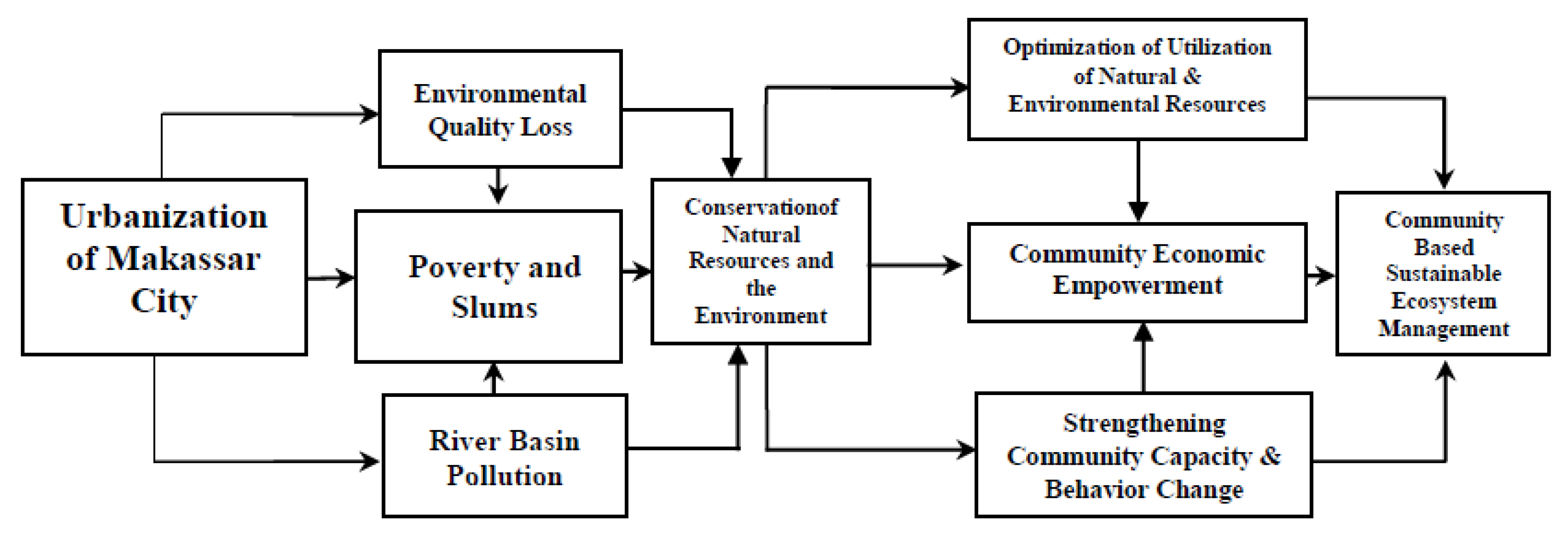
2. Conceptual Framework
2.1. Slums and Natural Resource Conservation
2.2. Economic Empowerment and Sustainability of Ecosystem Management
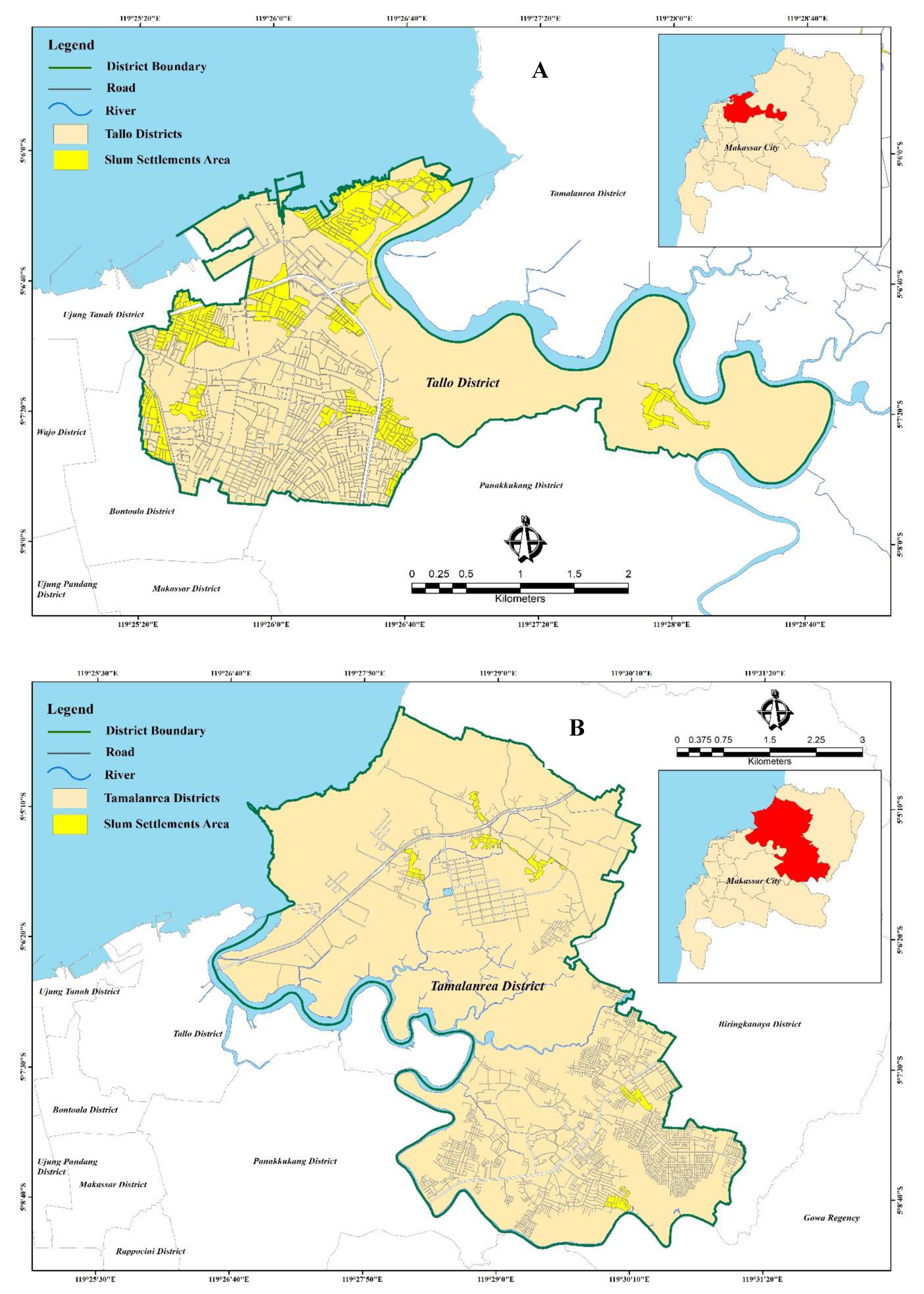
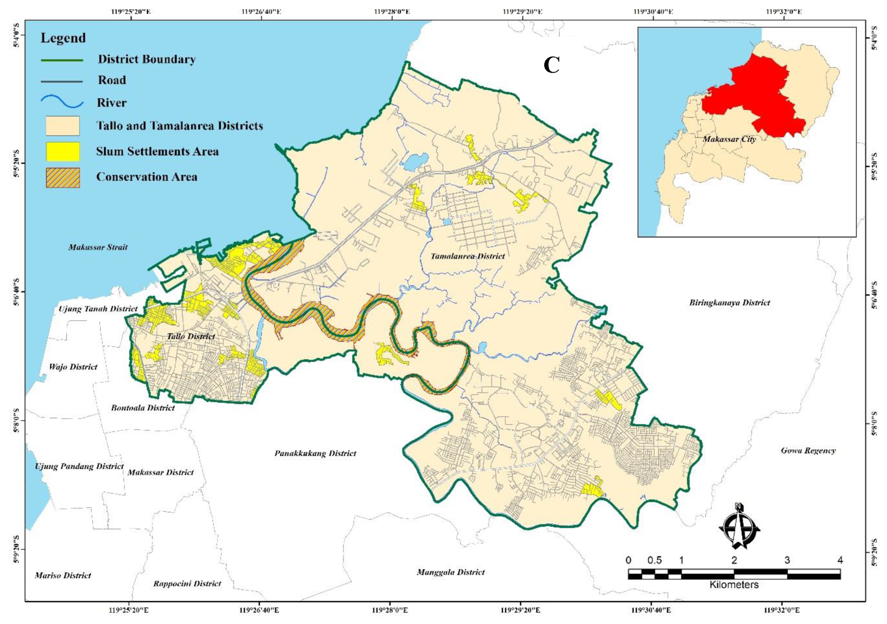
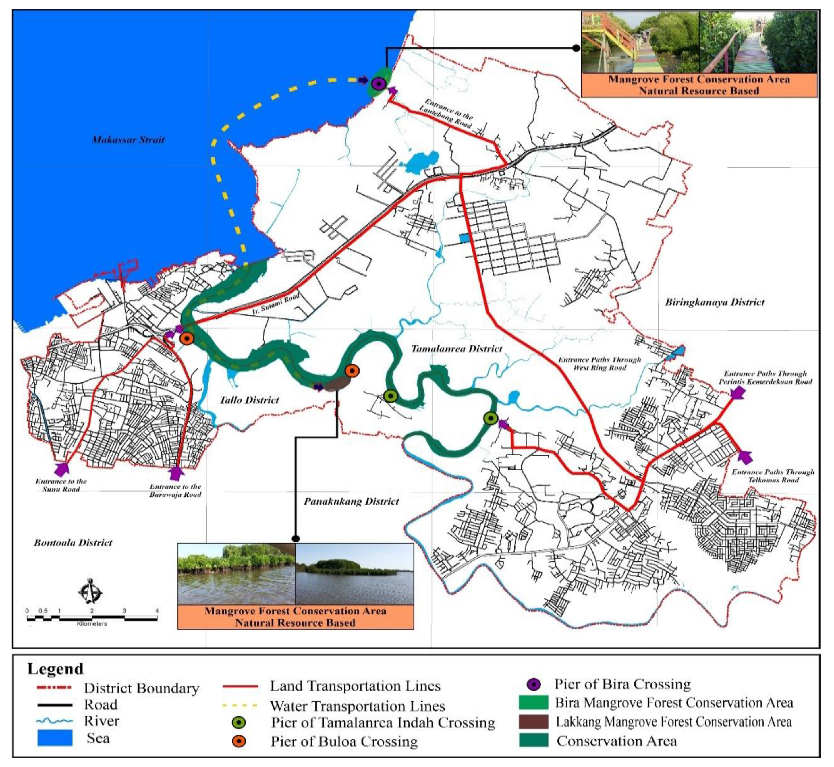
3. Profile of the Study Area
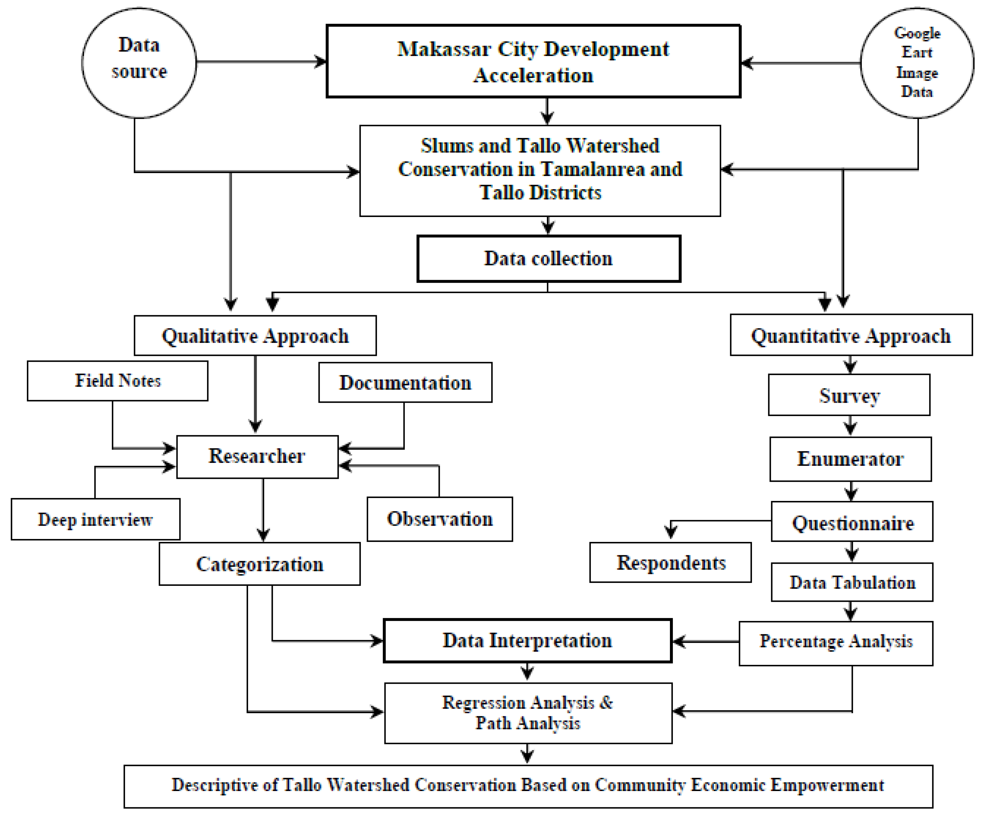
3.1. Data Colection Methods
3.2. Selection of the Respondents
3.3. Observation, Survey, and Focus Group Discussion
3.4. Secondary Data
3.5. Data Analisis
4. Result and Discussion
4.1. Poverty and Slums in Makassar City
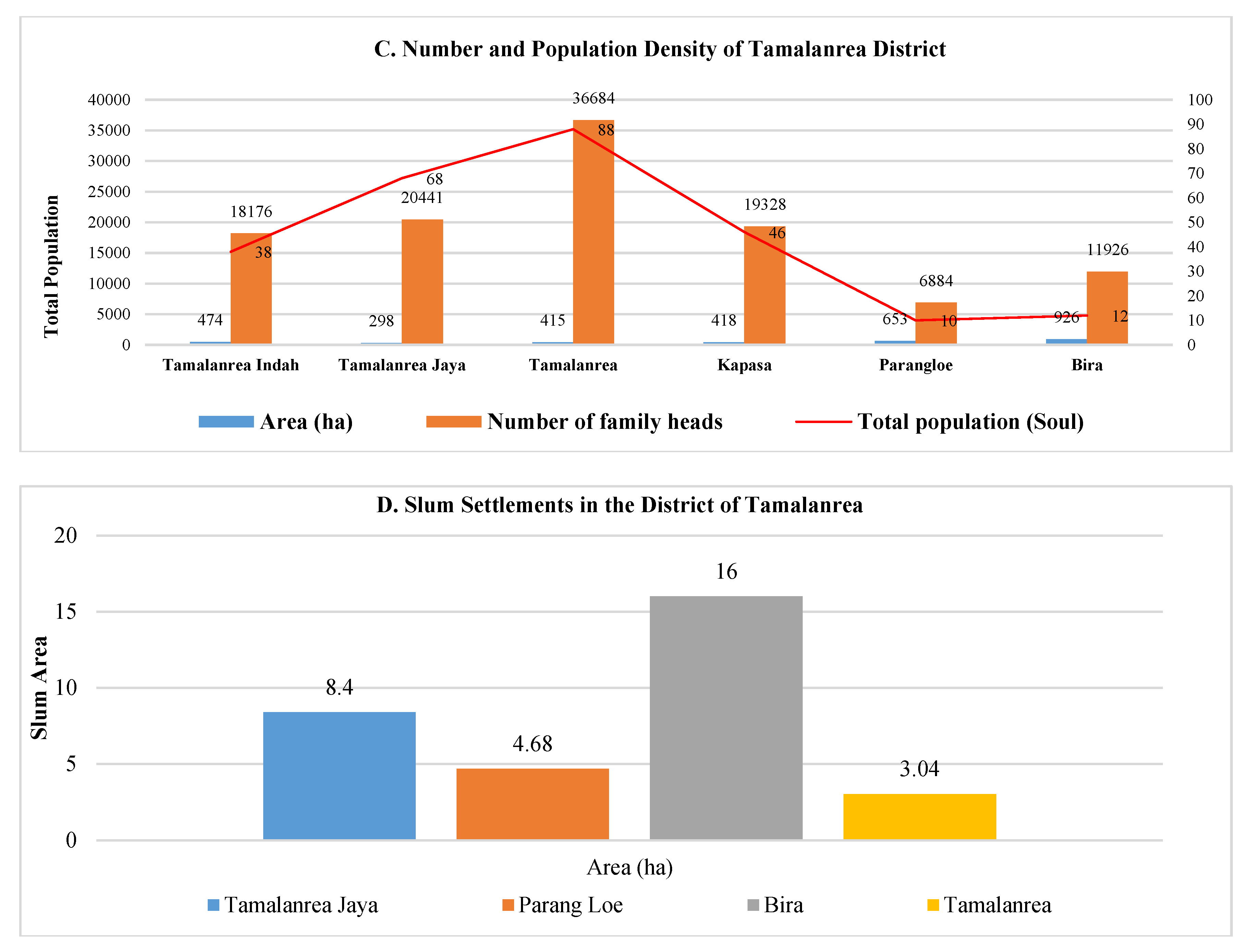
4.2. Characteristics and Typologies of Slum Settlements in the Study Area
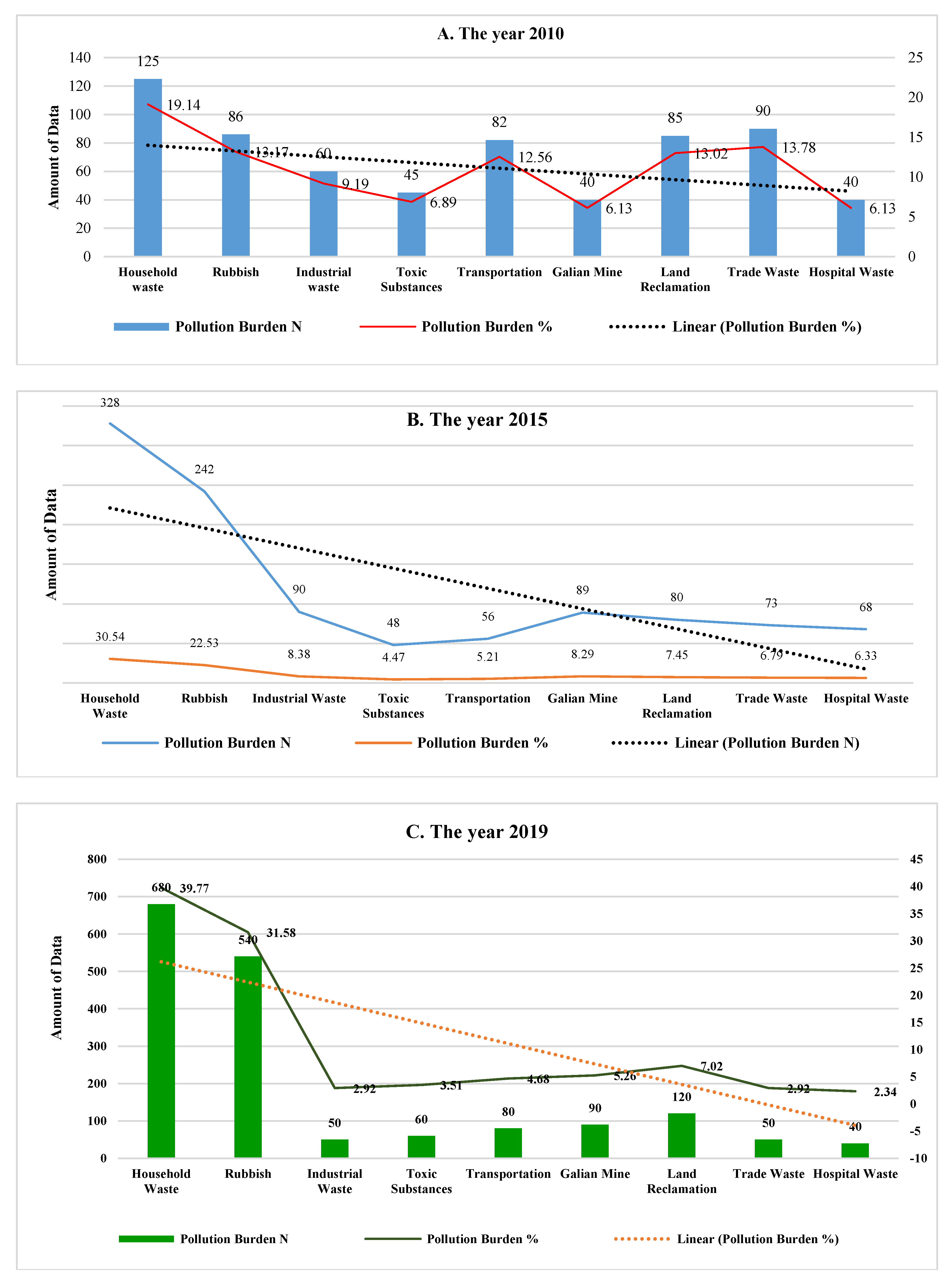
4.3. Causes and Control of Environmental Pollution
4.4. Management Control and Actions
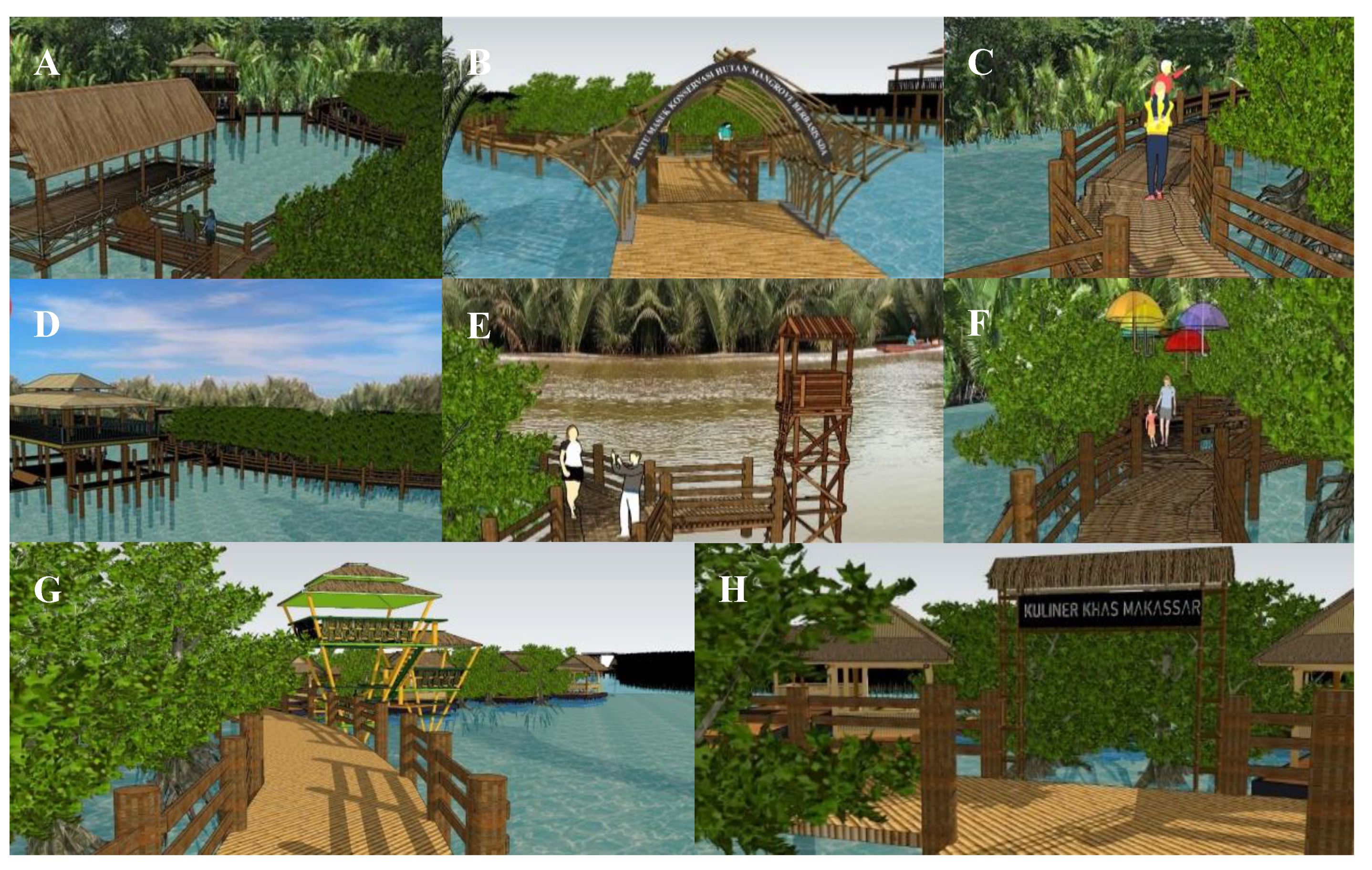
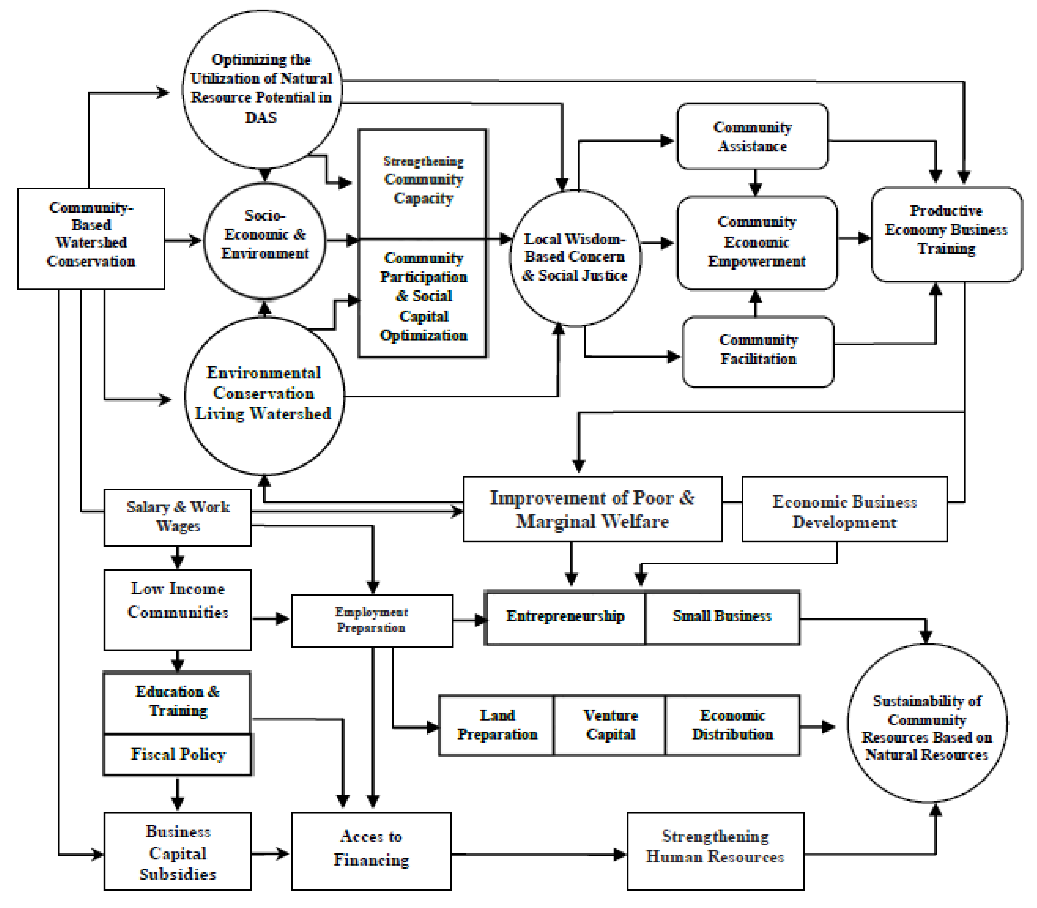
4.5. Community Based Economic Empowerment in the Management of Slums
5. Conclusions
Author Contributions
Funding
Acknowledgments
Conflicts of Interest
References
- Cui, Y.; Xu, X.; Dong, J.; Qin, Y. Influence of Urbanization Factors on Surface Urban Heat Island Intensity: A Comparison of Countries at Different Developmental Phases. Sustainability 2016, 8, 706. [Google Scholar] [CrossRef] [Green Version]
- UNPD (United Nations Population Division). World Urbanization Prospects: The 2018 Revision; United Nations: New York, NY, USA, 2018. [Google Scholar]
- United Nations, Department of Economic and Social Affairs, Population Division. World Urbanization Prospects: The 2018 Revision (ST/ESA/SER.A/420); United Nations, Department of Economic and Social Affairs, Population Division: New York, NY, USA, 2019; pp. 1–126. Available online: https://population.un.org/wup/Publications/Files/WUP2018-Report.pdf (accessed on 18 February 2020).
- Handayani, W. Rural-Urban Transition in Central Java: Population and Economic Structural Changes Based on Cluster Analysis. Land 2013, 2, 419–436. [Google Scholar] [CrossRef] [Green Version]
- Deolalikar, A.B. Migration, human capital and development: Oded Stark, ed., Volume 4 in Research in Human Capital and Development (JAI Press, Greenwich, CT, 1986), pp. xiv + 177. J. Dev. Econ. 1989, 31, 199–202. [Google Scholar] [CrossRef]
- Surya, B. The processes analysis of urbanization, spatial articulation, social change and social capital difference in the dynamics of new town development in the fringe area of Makassar City (case study, in Metro Tanjung Bunga Area, Makassar City). Procedia-Soc. Behav. Sci. 2016, 227, 216–231. [Google Scholar] [CrossRef] [Green Version]
- Ganesch, F. Regional Mobility and Spatial Inequality: Determinants of Spatial Labor Market Behavior Considering Firm- and Region-Specific Factors. Spat. Res. Plan. 2018, 76, 497–514. [Google Scholar] [CrossRef] [Green Version]
- Axelrad, H.; Malul, M.; Luski, I. Unemployment among younger and older individuals: Does conventional data about unemployment tell us the whole story? J. Labour Mark. Res. 2018, 52, 1–12. [Google Scholar] [CrossRef] [Green Version]
- Surya, B.; Saleh, H.; Remmang, H. Economic Gentrification and Socio-Cultural Transformation Metropolitan Suburban of Mamminasata. J. Eng. Appl. Sci. 2018, 13, 6072–6084. [Google Scholar] [CrossRef]
- Hedi Arouri, M.E. Effects of urbanization on economic growth and human capital formation in Africa. 2014, Volume 01068271f, pp. 1–23. Available online: https://halshs.archives-ouvertes.fr/halshs-01068271/document (accessed on 20 January 2020).
- Surya, B. Modernization in the Development of a Town and Community–Based Management Strategy of Slum Areas: A Case Study: Urban Slum Areas of Sangatta, East Kutai Regency, Indonesia. Economia. Seria Manag. 2015, 18, 177–195. [Google Scholar]
- Surya, B.; Saleh, H.; Abubakar, H. Sustainability of Slum-Based Settlement Management Community Socio-Economic Empowerment (Study on Slum Settlements in Panakkukang District, Makassar City). J. Eng. Appl. Sci. 2020, 15, 141–152. [Google Scholar] [CrossRef] [Green Version]
- Firman, T.; Indira Dharmapatni, I.A. The Emergence of Extended Metropolitan Regions in Indonesia: Jabotabek and Bandung Metropolitan Area. Rev. Urban Dev. Stud. 1995, 7. [Google Scholar] [CrossRef]
- Surya, B.; Saleh, H.; Syafri Annisa Ahmad, D.N. Impact and Sustainability of New Urban Area Development in Moncongloe-Pattalassang, Mamminasata Metropolitan. J. Southwest Jiaotong Univ. 2019, 54, 1–22. [Google Scholar] [CrossRef]
- WRI IUCN & UNEP. Global Biodiversity Strategy. World Resources Institute, The World Conservation Union United Nations Environment Programme; WRI IUCN & UNEP: Washinton, DC, USA, 1992; pp. 1–244. Available online: http://pdf.wri.org/globalbiodiversitystrategy_bw.pdf (accessed on 6 January 2020).
- Singh, N.C.; Titi, V. Empowerment for Sustainable Development: Towards Operational Strategies; Engaging Stakeholders in Support of Sustainable Development’ Action; International Institut for Sustainable Development (IISD): Winnipeg, MB, Canada, 2001; pp. 1–34. Available online: https://www.iisd.org/sites/default/files/publications/operational_strategies.pdf (accessed on 20 February 2020).
- Minh Ha, N.; Dang Le, N.; Kien, P.T. The Impact of Urbanization on Income Inequality: A Study in Vietnam. J. Risk Financ. Manag. 2019, 12, 146. [Google Scholar] [CrossRef] [Green Version]
- Teferi, Z.A.; Newman, P. Slum Regeneration and Sustainability: Applying the Extended Metabolism Model and the SDGs. Sustainability 2017, 9, 2273. [Google Scholar] [CrossRef] [Green Version]
- Morelli, J. Environmental Sustainability: A Definition for Environmental Professionals. J. Environ. Sustain. 2011, 1, 2. [Google Scholar] [CrossRef] [Green Version]
- Vega, M.S.; JBouma, M.; Kohli, V.; Pascual, M. Population Density, Climate Variables and Poverty Synergistically Structure Spatial Risk in Urban Malaria in India. PLoS Negl. Trop. Dis. 2016, 10, e0005155. [Google Scholar] [CrossRef]
- Niesenbaum, R. The Integration of Conservation, Biodiversity, and Sustainability. Sustainability 2019, 11, 4676. [Google Scholar] [CrossRef] [Green Version]
- Suharto, E. Membangun Masyarakat Memberdayakan Rakyat: Kajian Strategis Pembangunan Kesejahteraan Sosial dan Pekerjaan Sosial; Refika Aditama: Bandung, Indonesia, 2014. [Google Scholar]
- Selomane, O.; Reyers, B.; Biggs, R.; Hamann, M. Harnessing Insights from Social-Ecological Systems Research for Monitoring Sustainable Development. Sustainability 2019, 11, 1190. [Google Scholar] [CrossRef] [Green Version]
- Sharma, R.; Nguyen, T.T.; Grote, U. Changing Consumption Patterns—Drivers and the Environmental Impact. Sustainability 2018, 10, 4190. [Google Scholar] [CrossRef] [Green Version]
- Lombard, M. Constructing ordinary places: Place-making in urban informal settlements in Mexico. Prog. Plan. 2014, 94, 1–53. [Google Scholar] [CrossRef]
- Sugiono, C. Metode Penelitian dan Pengembangan. Untuk Bidang: Pendidikan, Manajemen, Sosial dan Teknik; Penerbit Alfabeta: Bandung, Indonesia, 2016. [Google Scholar]
- Creswell, J.W. Research Design: Qualitative, Quantitative and Mixed Methods Approach, 4th ed.; Pustaka Pelajar: Yogyakarta, Indonesia, 2016. [Google Scholar]
- Cochran, W.G. Teknik Penarikan Sampel; Edisi Ketiga; Penerbit Universitas Indonesia: Depok, Indonesia, 1991. [Google Scholar]
- Irwanto, J. Focus Group Discussion: Sebuah Pengantar Praktis; Yayasan Obor Indonesia: Jakarta, Indonesia, 2007. [Google Scholar]
- Wllonoyudho, S. The Urbanization in Semarang City. Indones. J. Geogr. 2010, 42, 181–194. [Google Scholar] [CrossRef]
- Duranton, G.; Puga, D. Chapter 5―The Growth of Cities. In Handbook of Economic Growth; Elsevier: Amsterdam, The Netherlands, 2014; Volume 2, pp. 781–853. [Google Scholar] [CrossRef]
- Surya, B. Change Phenomena of Spatial Physical in the Dynamics of Development in Urban Fringe Area. Indones. J. Geogr. 2016, 48, 118–134. [Google Scholar] [CrossRef] [Green Version]
- Biro Pusat Statistik Kota Makassar. Kota Makassar Dalam Angka. 2019. Available online: https://makassarkota.bps.go.id/publication/2019/08/16/4ca03301b8e2b8414e33f6a3/kota-makassar-dalam-angka-2019.html. (accessed on 1 January 2020).
- Zulu, E.M.; Beguy, D.; Ezeh, A.C.; Bocquier, P.; Madise, N.J.; Cleland, J.; Falkingham, J. Overview of migration, poverty and health dynamics in Nairobi City’s slum settlements. J. Urban Health 2011, 88, 185–199. [Google Scholar] [CrossRef] [Green Version]
- Irda Sari, S.Y.; KSunjaya, D.; Furusawa, H.S.; Watanabe, C.; Raksanagara, A.S. Water Sources Quality in Urban Slum Settlement along the Contaminated River Basin in Indonesia: Application of Quantitative Microbial Risk Assessment. J. Environ. Public Health 2018, 3806537. [Google Scholar] [CrossRef] [PubMed] [Green Version]
- Chimankar, D.A. Urbanization and Condition of Urban Slums in India. Indones. J. Geogr. 2016, 48, 28–36. [Google Scholar] [CrossRef]
- Surya, B.; Saleh, H. Transformation of metropolitan suburban area (a study on new town development in Moncongloe-Pattalassang Metropolitan Maminasata). In Proceedings of the IOP Conference Series: Earth and Environmental Science, Banda Aceh, Indonesia, 26–27 September 2018; Volume 202, p. 012027. [Google Scholar] [CrossRef] [Green Version]
- Rashid, S.F. Strategies to Reduce Exclusion among Populations Living in Urban Slum Settlements in Bangladesh. J. HealthPopul. Nutr. 2009, 27, 574–586. [Google Scholar] [CrossRef] [PubMed] [Green Version]
- Mberu, B.U.; Tilahun Nigatu, H.; Catherine, K.; Alex, C.E. Health and health-related indicators in slum, rural, and urban communities: A comparative analysis. Glob. Health Action 2016, 9, 1–13. [Google Scholar] [CrossRef]
- Ishtiyaq, M.; Kumar, S. Typology of Informal Settlements and Distribution of Slums in the NCT, Delhi. J. Contemp. India Stud. Space Soc. Hiroshima Univ. 2011, 1, 37–46. [Google Scholar] [CrossRef]
- Surya, B. Spatial Articulation and Co-Existence of Mode of Production in the Dynamics of Development at the Urban Fringe of Makassar City. J. Eng. Appl. Sci. 2015, 10, 214–222. [Google Scholar]
- UN-Habitat. The Challenge of Slums. Earthscan, London, UK. 2003. Available online: https://www.un.org/ruleoflaw/files/Challenge%20of%20Slums.pdf. (accessed on 8 January 2020).
- Nassar, D.M.; Elsayed, H.G. From Informal Settlements to sustainable communities. Alex. Eng. J. 2018, 57, 2367–2376. [Google Scholar] [CrossRef]
- Albertí, J.; Roca, R.; Brodhag, C.; i-Palmer, P.F. Allocation and system boundary in life cycle assessments of cities. Habitat Int. 2019, 83, 41–54. [Google Scholar] [CrossRef]
- Streatfield, P.K.; Karar, Z.A. Population Challenges for Bangladesh in the Coming Decades. J. Health Popul. Nutr. 2008, 26, 261–272. [Google Scholar] [CrossRef] [PubMed] [Green Version]
- Patel, A.; Koizumi, N.; Crooks, A. Measuring slum severity in Mumbai and Kolkata: A household-based approach. Habitat Int. 2014, 41, 300–306. [Google Scholar] [CrossRef]
- Utami, S.; Bisri, M. Disaster Riskand Adaptation of Settlement alongthe River Brantasin the Context of Sustainable Development, Malang, Indonesia. Procedia-Soc. Behav. Sci. 2014, 20, 602–611. [Google Scholar] [CrossRef] [Green Version]
- Rudito, B. The improvement of community economy as impact of corporate social responsibility program: A case study in Pengalengan, Bandung, West Java, Indonesia. Procedia-Soc. Behav. Sci. 2014, 164, 471–476. [Google Scholar] [CrossRef] [Green Version]
- Avanzi, J.C.; Naves Silva, M.L.; Curi, N.; Norton, L.D.; Beskow, S.; Martins, S.G. Spatial distribution of water erosion risk in a watershed with eucalyptus and Atlantic Forest. Ciência E Agrotecnologia 2013, 37, 427–434. [Google Scholar] [CrossRef] [Green Version]
- Blettler, M.C.; Garello, N.; Ginon, L.; Abrial, E.; Espinola, L.A.; Wantzen, K.M. Massive plastic pollution in a mega-river of a developing country: Sediment deposition and ingestion by fish (Prochilodus lineatus). Environ. Pollut. 2019, 255, 113348. [Google Scholar] [CrossRef]
- Akhmaddhian, S.; Handayani, I.G. The Government Policy of Water Resources Conservation to Embodying Sustainable Development Goals: Study in Kuningan, Indonesia. Int. J. Civ. Eng. Technol. 2017, 8, 419–428. Available online: https://www.iaeme.com/ijciet/issues.asp?JType=IJCIET&VType=8&IType=12 (accessed on 6 February 2020).
- Sekhroni, S.; Hartiwiningsih, H.; Handayani, R.; Ketut, I.G. The Implementation of Environmental Criminal Law Enforcement to Prevent the Ground Water Pollution (The Case Study of Used Battery Smelting in Tegal District, Indonesia). Int. J. Civ. Eng. Technol. 2019, 10, 302–308. [Google Scholar]
- Kan, H. Environment and Health in China: Challenges and Opportunities. Environ. Health Perspect. 2009, 117, A530–A531. [Google Scholar] [CrossRef] [Green Version]
- Kjellstrom, T.; Lodh, M.; McMichael, T.; Ranmuthugala, G.; Shrestha, R.; Kingsland, S. Air and Water Pollution: Burden and Strategies for Control; The International Bank for Reconstruction and Development/The World Bank Group: Washington, DC, USA, 2006; pp. 817–832, Bookshelf ID: NBK11769PMID: 21250344, Chapter 432006. Available online: https://0-www-ncbi-nlm-nih-gov.brum.beds.ac.uk/books/NBK11769/ (accessed on 8 January 2020).
- Ding, J.; Jiang, Y.; Fu, L.; Liu, Q.; Peng, Q.; Kang, M. Impacts of Land Use on Surface Water Quality in a Subtropical River Basin: A Case Study of the Dongjiang River Basin, Southeastern China. Water 2015, 7, 4427–4445. [Google Scholar] [CrossRef] [Green Version]
- Chen, X.; Zhou, W.; Pickett, S.T.; Li, W.; Han, L. Spatial-Temporal Variations of Water Quality and Its Relationship to Land Use and Land Cover in Beijing, China. Int. J. Environ. Res. Public Health 2016, 13, 449. [Google Scholar] [CrossRef] [Green Version]
- Cosgrove, W.J.; Loucks, D.P. Water management: Current and future challenges and research directions. Water Resour. Res. 2015, 51, 4823–4839. [Google Scholar] [CrossRef] [Green Version]
- Chen, J.; Lu, J. Effects of Land Use, Topography and Socio-Economic Factors on River Water Quality in a Mountainous Watershed with Intensive Agricultural Production in East China. PLoS ONE 2014, 9, e102714. [Google Scholar] [CrossRef]
- Jordan, S.J.; Benson, W.H. Sustainable Watersheds: Integrating Ecosystem Services and Public Health. Environ. Health Insights 2015, 9, 1–7. [Google Scholar] [CrossRef]
- Wang, G.; Mang, S.; Cai, H.; Liu, S.; Zhang, Z.; Wang, L.; Innes, J.L. Integrated watershed management: Evolution, development and emerging trends. J. For. Res. 2016, 27, 967–994. [Google Scholar] [CrossRef] [Green Version]
- Merem, E.C.; Yerramilli, S.; Twumasi, Y.A.; Wesley, J.M.; Robinson, B.; Richardson, C. The Applications of GIS in the Analysis of the Impacts of Human Activities on South Texas Watersheds. Int. J. Environ. Res. Public Health 2011, 8, 2418–2446. [Google Scholar] [CrossRef] [Green Version]
- Surya, B. Rationalization of Community Actions, Public Spaces Privatization and Urban Informal Sector Economic Behavior” (A Case: Hertasning Road Corridor of Makassar City). Middle East J. Sci. Res. 2015, 23, 2219–2231. [Google Scholar] [CrossRef]
- Gong, X.; Mi, J.; Yang, R.; Sun, R. Chinese National Air Protection Policy Development: A Policy Network Theory Analysis. Int. J. Environ. Res. Public Health 2018, 15, 2257. [Google Scholar] [CrossRef] [Green Version]
- Sudha, M. Sustainable Practices in Watershed Management: Global Experiences; ICFAI Business School: Mumbai, India, 2007; pp. 1–16, MPRA Paper No. 5854, posted 22, 2007, 05:48 UTC; Available online: https://mpra.ub.uni-muenchen.de/id/eprint/5854 (accessed on 18 February 2020).
- Muhanna, E. Sustainable Tourism Development and Environmental Management for Developing Countries. Probl. Perspect. Manag. 2006, 4, 14–30. Available online: https://businessperspectives.org/images/pdf/applications/publishing/templates/article/assets/519/PPM_EN_2006_02_Muhanna.pdf (accessed on 29 January 2020).
- Riehl, B.; Zerriffi, H.; Naidoo, R. Effects of Community-Based Natural Resource Management on Household Welfare in Namibia. PLoS ONE 2015, 10, e0125531. [Google Scholar] [CrossRef] [PubMed]
- Stone, L.S. Community-Based Tourism Ventures, Benefits and Challenges: Khama Rhino Sanctuary Trust, Central District, Botswana. Tour. Manag. 2010, 31, 136–146. [Google Scholar] [CrossRef]
- Sofian, A.; Kusmana, C.; Fauzi, A.; Rusdiana, O. Ecosystem services-based mangrove management strategies in Indonesia: A review. Int. J. Bioflux Soc. 2019, 12, 151–166. [Google Scholar]
- Rafiy, M.; Tibertius, N.; Muthalib, A.A. Study of Improvement Fishermen Welfare Through Improved Productivity And Model Development In The Coastal North Konawe. Int. J. Eng. Sci. 2015, 4, 62–67. Available online: http://www.theijes.com/papers/v4-i12/Version-2/J041202062067.pdf (accessed on 15 January 2020).
- Juma, L.O.; Vidra, A.K. Community-Based Tourism and Sustainable Development of Rural Regions in Kenya; Perceptions of the Citizenry. Sustainability 2019, 11, 4733. [Google Scholar] [CrossRef] [Green Version]
- Zapata, M.J.; CMichael Hall, C.M.; Lindo, P.; Vanderschaeghe, M. Can community-based tourism contribute to development and poverty alleviation? Lessons from Nicaragua. Curr. Issues Tour. 2011, 14, 725–749. [Google Scholar] [CrossRef]
- Salazar, N.B. Community-based cultural tourism: Issues, threats and opportunities. J. Sustain. Tour. 2012, 20, 9–22. [Google Scholar] [CrossRef]
- Longo, S.B.; Clark, B.; Shriver, T.E.; Clausen, R. Sustainability and Environmental Sociology: Putting the Economy in its Place and Moving Toward an Integrative Socio-Ecology. Sustainability 2016, 8, 437. [Google Scholar] [CrossRef] [Green Version]
- Kusakabe, E. Advancing sustainable development at the local level: The case of machizukuri in Japanese cities. Prog. Plan. 2013, 80, 1–65. [Google Scholar] [CrossRef] [Green Version]
- Kill, J. Economic Valuation and Payment for Environmental Services Recognizing Nature‘s Value or Pricing Nature‘s Destruction? Heinrich Böll Found. Stift. Ecol. 2015, 1–23. Available online: https://www.boell.de/sites/default/files/e-paper_151109_e-paper_economicvaluenature_v001.pdf?dimension1=ds_nature (accessed on 24 February 2020).
- Noya, A.; Clarence, E. Community capacity building: Fostering economic and social resilience; OECD LEED: Paris, France, 2009; pp. 1–11. Available online: https://www.oecd.org/regional/leed/44681969.pdf (accessed on 25 January 2020).
- Harrington, E. Are Economic Growth and Environmental Sustainability Compatible? A Study of Theory, Policy and Practice. Bachelor’s Thesis, University of Limerick, Limerick, Ireland, 2013; pp. 1–72. Available online: https://www.ul.ie/ppa/content/files/Ella_Harrington.pdf (accessed on 8 February 2020).
- Haupt, M.; Hellweg, S. Measuring the environmental sustainability of a circular economy. Environ. Sustain. Indic. 2019, 1, 100005. [Google Scholar] [CrossRef]
- Kusnanto, H.; Dibyosaputro, S.; Hadisusanto, S.; Saraswati, S.P. Community Engagement With Urban River Improvement: The Case of Yogyakarta City. J. Mns. Dan Lingkung. 2016, 23, 390–393. [Google Scholar] [CrossRef] [Green Version]
- Nowak, A.Z.; Dahal, G. The contribution of education to economic growth: Evidence from Nepal. Int. J. Econ. Sci. 2016, 5, 22–41. [Google Scholar] [CrossRef]
- Sutikno, B.; Hakim, A.; Batoro, J.; Riniwati, H. Influence of Green Economic Development through Local Wisdom, Economic Potential, and Role of Dairy Cooperative in Pasuruan. Int. Rev. Manag. Mark. 2018, 8, 81–89. Available online: https://www.econjournals.com/index.php/irmm/article/view/6223 (accessed on 8 February 2020).
- Bith, B. Community-based Ecotourism and Empowerment of Indigenous People: The Case of Yeak Laom Community Development, Cambodia; Lincoln University: Baltimore Pike, PA, USA, 2011; pp. 1–134. Available online: https://researcharchive.lincoln.ac.nz/bitstream/handle/10182/3865/Bith_MTM.pdf?sequence=4&isAllowed=y (accessed on 8 February 2020).
- Van Praag, C.M. Some Classic Views on Entrepreneurship. De Econ. 1999, 147, 311–335. [Google Scholar] [CrossRef]
- Startiene, G.; Remeikiene, R. The Influence of Demographical Factors on the Interaction between Entrepreneurship and Unemployment. Eng. Econ. 2009, 64, 60–70. Available online: http://inzeko.ktu.lt/index.php/EE/article/view/11613 (accessed on 16 February 2020).
- Martadwiprani, H.; Rahmawati, D. Economic Development as Community Resilience Enhancement in Minapolis Coastal Settlement. Procedia Soc. Behav. Sci. 2014, 35, 106–111. [Google Scholar] [CrossRef] [Green Version]
- Surya, B. The Dynamics of Spatial Structure and Spatial Pattern Changes at the Fringe Area of Makassar City. Indones. J. Geogr. 2015, 47, 11–19. [Google Scholar] [CrossRef]
- Surya, B. Social Change, Spatial Articulation in the Dynamics of Boomtown Construction and Development (Case Satudy of Metro Tanjung Bunga Boomtown, Makassar). Mod. Appl. Sci. 2014, 8, 238–245. [Google Scholar] [CrossRef] [Green Version]
- Olajide, O.A.; Agunbiade, M.E.; Bishi, H.B. The realities of Lagos urban development vision on livelihoods of the urban poor. J. Urban Manag. 2018, 7, 21–31. [Google Scholar] [CrossRef]


| Slums in Tamalanrea District | Coordinate Point | Slum Settlement Area | Typology of Slums |
|---|---|---|---|
| Tamalanrea Jaya | 119°30’3.489"E 5°8’40.309"S | 8.40 | Lowland |
| Parang Loe | 119°28’14.042"E 5°5’44.106"S | 4.68 | Lowland |
| Bira | 119°29’20.791"E 5°5’40.706"S | 16 | Lowland |
| Tamalanrea | 119°30’10.479"E 5°7’44.025"S | 3.04 | Lowland |
| Slums in Tallo District | |||
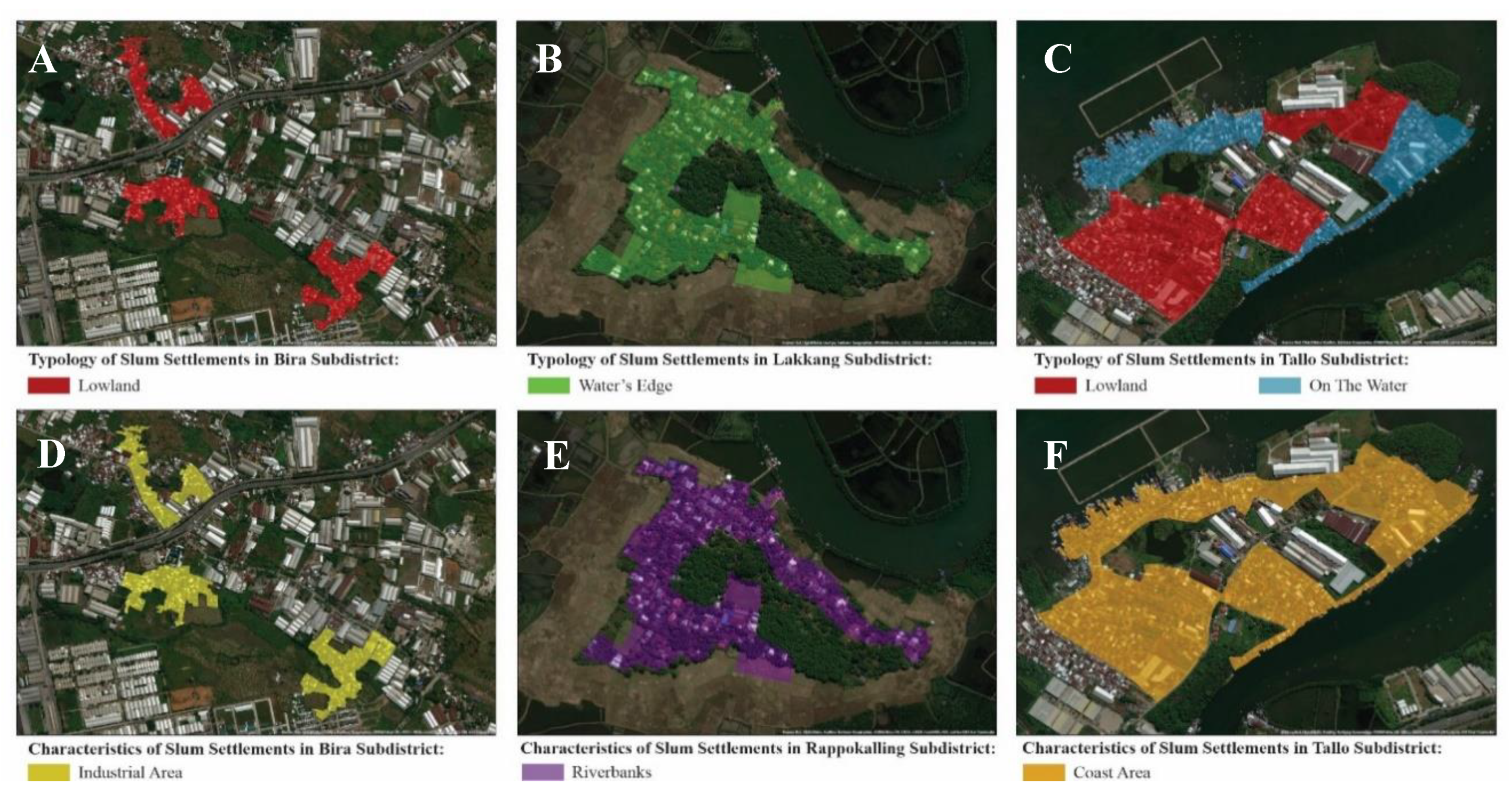
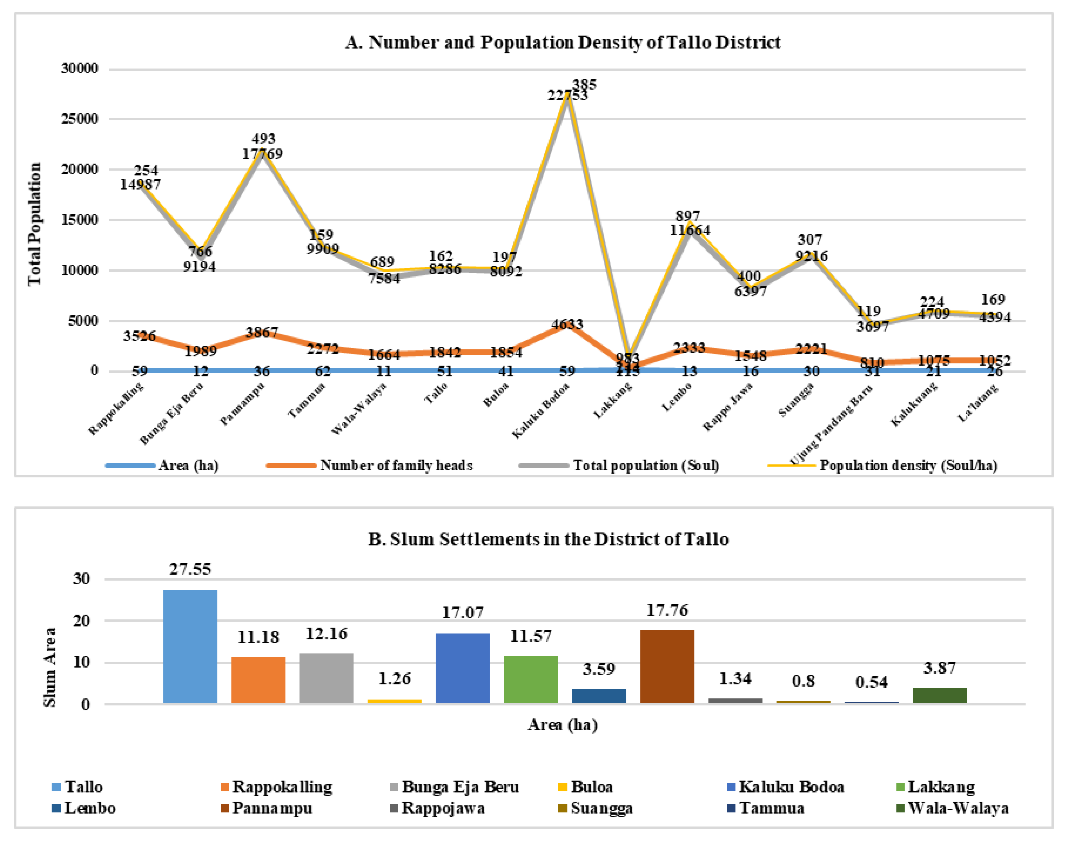
| Tallo | 119°26’24.975"E 5°6’23.269"S | 27.55 | Lowlands, Water Edge, and above Water |
| Rappokalling | 119°26’37.093"E 5°7’23.848"S | 11.18 | Lowlands, Water Edge, and above Water |
| Bunga Eja Beru | 119°25’24.739"E 5°7’23.783"S | 12.16 | Lowlands and Water Edge |
| Buloa | 119°26’21.936"E 5°6’28.049"S | 1.26 | Lowlands, Water Edge, and above Water |
| Kaluku Bodoa | 119°25’58.907"E 5°6’46.529"S | 17.07 | Lowland |
| Lakkang | 119°27’53.154"E 5°7’16.404"S | 11.57 | Lowlands and Water Edge |
| Lembo | 119°25’33.218"E 5°7’20.345"S | 3.59 | Lowland |
| Pannampu | 119°25’35.505"E 5°6’56.154"S | 17.76 | Lowland |
| Suwangga | 119°25’38.288"E 5°7’13.514"S | 1.34 | Lowland |
| Tammua | 119°26’36.485"E 5°7’42.583"S | 0.8 | Lowland |
| Wala-Walaya | 119°26’23.819"E 5°7’16.747"S | 0.54 | Lowland |
| Rappojawa | 119°26’17.038"E 5°7’20.178"S | 3.87 | Lowland |
| Correlated Variables | t Count | r Table | Information | r2 |
|---|---|---|---|---|
| Slum Settlements Towards Degradation of Environmental Quality in Watersheds (ryx1) | 0.39 | 0.297 | Signifikan | 0.152 |
| Community Poverty Towards a Declining Quality of the Watershed Environment (ryx2) | 0.38 | 0.297 | Signifikan | 0.143 |
| Community Behavior Towards Declining Quality of Watershed Environment (ryx3) | 0.36 | 0.297 | Signifikan | 0.132 |
| Slum Settlement, Poverty and Community Behavior Towards a Declining Quality of the Watershed Environment (R) | 0.566 | f = 3.22 | Signifikan | 0.320 |
© 2020 by the authors. Licensee MDPI, Basel, Switzerland. This article is an open access article distributed under the terms and conditions of the Creative Commons Attribution (CC BY) license (http://creativecommons.org/licenses/by/4.0/).
Share and Cite
Surya, B.; Syafri, S.; Sahban, H.; Sakti, H.H. Natural Resource Conservation Based on Community Economic Empowerment: Perspectives on Watershed Management and Slum Settlements in Makassar City, South Sulawesi, Indonesia. Land 2020, 9, 104. https://0-doi-org.brum.beds.ac.uk/10.3390/land9040104
Surya B, Syafri S, Sahban H, Sakti HH. Natural Resource Conservation Based on Community Economic Empowerment: Perspectives on Watershed Management and Slum Settlements in Makassar City, South Sulawesi, Indonesia. Land. 2020; 9(4):104. https://0-doi-org.brum.beds.ac.uk/10.3390/land9040104
Chicago/Turabian StyleSurya, Batara, Syafri Syafri, Hernita Sahban, and Harry Hardian Sakti. 2020. "Natural Resource Conservation Based on Community Economic Empowerment: Perspectives on Watershed Management and Slum Settlements in Makassar City, South Sulawesi, Indonesia" Land 9, no. 4: 104. https://0-doi-org.brum.beds.ac.uk/10.3390/land9040104