Landscape as Digital Content and a Smart Tourism Resource in the Mining Area of Cartagena-La Unión (Spain)


1
Department of Geography, Universidad Nacional de Educación a Distancia, 28040 Madrid, Spain
2
Center Associated to the Universidad Nacional de Educación a Distancia, 49014 Zamora, Spain
*
Author to whom correspondence should be addressed.
Land 2020, 9(4), 112; https://0-doi-org.brum.beds.ac.uk/10.3390/land9040112
Submission received: 10 March 2020
/
Revised: 2 April 2020
/
Accepted: 6 April 2020
/
Published: 7 April 2020
(This article belongs to the Special Issue Landscape and Tourism, Landscapes of Tourism)
Abstract
:This research makes a highly relevant contribution to the scientific analysis of the mining landscape using the example of Cartagena-La Unión (Spain). The landscape is interpreted from a twin perspective: as a type of digital content offered to visitors and as a highly valuable scenic tourism resource. The article features an extensive bibliographical review and offers different perspectives on the relationship between landscape, tourism, and smart promotion. The method used is both qualitative and quantitative due to the presentation of statistical data. It describes a purpose-designed form used for analyzing the landscape in question and a synthetic landscape assessment index, as a result of creating and using different indicators. Extensive field work and consultation with several sources provided information about the enclave, how much it appeals to visitors, and their level of satisfaction. The results achieved offer a new scientific vision of what a spectacular cultural landscape, and a point of reference for “mining heritage tourism”, can represent.
1. Introduction
The idea of smart tourism destinations (STD) emerged in the 1990s when “smart places” began appearing and continued later with the general acceptance of “smart cities” or efficient cities.
In 1996, the European Commission established the European Digital Cities (EDC), which is now regarded as the forerunner of the smart city idea [1]. Shortly after, the European Council held in 2000 devised the Lisbon Strategy, which heralded the start of smart places and the commitment to achieving a more competitive and digital economy [2]. This was complemented by the European Union’s Sustainable Development Strategy, defined in the Swedish city of Gothenburg in 2001 and subsequently revised in 2004 [3]. Broadly speaking, the approach taken in Europe is underpinned by ICTs (information and communication technologies) applied to smart growth.
In the late 1990s, certain path-breaking urban experiences began to be analyzed in the United States. A total of 20 cities were selected to start with, along with a set of fundamental variables, mainly economic competitiveness, social cohesion, and environmental sustainability. These urban spaces were then classified as smart places.
However, the term “smart place” was soon replaced by “smart city”, in order to delve into the problem of sustainability in urban areas. Smart cities are geographically better defined than their immediate predecessors and have the advantage of coinciding with specific political–administrative limits [4]. Later, the term began to be linked to ICTs, which are acknowledged to play a key role in promoting sustainable development and progress, yet without renouncing the joint participation of private organizations and public bodies and the achievement of a comprehensive urban approach [5].
The idea of smart cities is the forerunner to SDTs [6,7,8], destinations where territorial and tourist aspects are identified as being smart [9]. STDs are always linked to the destinations’ competitiveness and improving tourists’ experience, and not so much to governance and inhabitants’ quality of life as in the case of smart cities. Another difference has to do with the geographical limits of both concepts, which may or may not coincide. Yet apart from the differences between smart cities and STDs, they can be said to share the smart place idea, either in the form of a place with tourist uses or as a place subject to urban planning and management.
Smart tourist destinations represent the overcoming of mature tourist destinations, with management and promotion approaches based on the potential afforded by information technologies [10]. The changing dynamics triggered by these new challenges are based in particular on technology being made to serve tourists, applying sustainable criteria in destination management and quickly responding to visitors’ needs; in other words, a broad range of new possibilities that project the sector’s current image of leadership, with strategic and dynamic definitions that will define the most immediate future.
The most advanced countries have already explicitly built this new tourism paradigm into their tourism policies. In Spain, for example, it is enshrined in the Comprehensive National Tourism Plan 2012–2015 and in the Spanish Tourism Horizon 2020 Plan [11]. These plans characterize STDs as being innovative, accessible, and technological places. This guarantees the sustainable development and competitive advantages of tourist areas, as well as visitors’ interaction with the environment and the landscape’s scenic features. These features are essential for any definition in this respect [12].
Smart tourism brings many advantages to mining and industrial heritage by boosting its value and identification as a cultural resource. Using digital techniques to promote and manage destinations puts resources more within visitors’ reach, provides more opportunities for interaction, and builds the tourist image of industrialization-related places [10].
ICTs turn the places visited into smart destinations that steadily become more competitive through the inherent sustainable use of resources. They also make it easier both to integrate visitors into the architectural, environmental, and socioeconomic environment, and to disseminate the scenic values of abandoned mining areas. This technological process, which is complicated and costly at the start-up stage, represents an improvement on traditional tourist models.
Apart from ICTs, the role of data in smart destinations is very important from different points of view. Firstly, because they facilitate a more efficient management of tourist sites. The data offers the necessary information to understand what the strategies should be for a better promotion and management of the destination. Secondly, the data facilitates the connection between visitors, visited spaces, and available resources, as well as the interaction of these three elements with the surrounding territory. The result is the emergence of a new competitive capacity, the projection of the destination in a modern and attractive way, and the promotion of a model that is, in general, more sustainable.
Abandoned mining areas can be portrayed as culturally interesting places. The landscapes that are left after being mined for such long periods of time are unquestionably cultural due to the profound changes to the natural environment, with an intensity and visual impact that varies from time to time. These landscapes are the technical, economic, and social heritage of previous generations. This is how they have come to be regarded, prompting a general agreement in expressing the need to protect and promote them [13].
These landscapes are especially unique because of the diversity of heritage that remains, the heavy environmental impact, and the natural dependence on geological resources; the close ties with the land and material mining and transportation infrastructure; the workers’ housing in the form of isolated villages; and the different kinds of scenery generated and the aesthetics associated with ruin and neglect.
The environmental impacts caused are always profound, meaning that any projects involving new tourist uses entail first restoring the natural environment to remove the harmful effects of pollution. Doing so is a large-scale task that calls for enormous technical and economic efforts. The results achieved, after years of numerous international experiences, are spectacular because they create new spaces for leisure and tourism subject to the strictest sustainability criteria [14,15,16].
In most cases, new museums and interpretation centers have been opened, with the participation of local public and private institutions or associations interested in the industrialization heritage. The fact that these are done on a local scale means that there is an extensive variety of new proposals for their cultural use, management, and promotion. That is perhaps why mining and industrial heritage recovery projects have ended up being regarded as secondary for more specialized thematic research [17].
Although mining area landscape studies are relatively abundant, many refer to ecological conditions and environmental protection planning after the abandonment of the mines [18,19], and few publications have focused on the scenic conditions left after mining stops, and on how to apply new technologies to promote culture and tourism. Sometimes they refer to their advantages for smart management of destinations and their associated landscapes [20], and other times they address the opportunities for disseminating mining or industrial heritage values in education [21].
One of the most interesting publications is a conceptual approach to smart tourism of industrial heritage, with different digital adaptation models [22]. The main idea argued is that this heritage not only facilitates investment in physically restoring buildings, but also collaborative organization-related actions, the local community’s involvement, spreading ICTs, and boosting technological competitiveness. These represent a broad set of measures and advantages that haven given rise to what is known as a “smart industrial tourism business ecosystem” (SITBE).
This research focuses on one of the most significant abandoned mining areas in Europe, with a heritage site linked to an area that was profoundly transformed by mineral mining. The result is an extraordinarily and aesthetically unique landscape, with differently-colored stretches of land, chimneys, furnaces, opencast mines, machine rooms, etc. The extensive restoration work required represents a benchmark in terms of environmental restoration of the landscape for tourist uses. These features, coupled with the initial hypothesis that there has been enough management and promotion to make it a smart tourist destination, fully justify the choice of the area as a case study (Figure 1).
The main objectives of the research are to: (i) characterize La Unión’s mining landscape as a result of a long process of human intervention in the area; (ii) determine the scenic and aesthetic variables of the mining landscape; (iii) identify the extent to which the landscape is present on Internet and its digitization for tourism purposes; and (iv) find out how the mining landscape in the area in question is used for tourism purposes.
2. Methods
In this study, the Cartagena-La Unión mining area was selected on account of its landscape values derived from its centuries-old mining activity. The resulting landscape is spectacular due to its highly colorful nature and ruin-like scenery, that is, scenery based on the string of mining operations carried out during different periods and using different techniques, but all in the same area. The area has recently been turned into a tourist site and place for contemplation, applying ICT digital techniques as the best way of promoting the mining landscape, its aesthetic qualities, and the changes it has undergone.
The method followed throughout the research was basically qualitative, which is deemed most appropriate in a case study. Significant time was spent in November 2019 on the bibliographic review and mapping analysis, consulting public environmental protection documents, conducting the field work, and drawing up a landscape analysis form. The research ended with an analysis of the web presentation and landscape-related digital content. This part gives visitors the chance to find out about the landscape in a different way, visiting it digitally online and letting them interact quickly with existing tourist resources.
The method could also be defined as mixed because a key feature in some phases of the study was to collect quantitative information, such as the surface areas of the different protection areas, or to consult visitor statistics for the last few years.
The landscape analysis form is a fundamental part of the research. It involved pre-selecting a wide range of indicators of significant content in relation to the interests of analysis. The indicators selected to carry out the landscape analysis were taken basically from the existing literature and from the field work during the first phases of the research. The list consists of a total of 22 indicators, distributed in four different groups and referring to built elements, landscape environment and scenic quality, landscape protection and management, and valuation of the mining landscape.
The evaluation method followed in each indicator is the result, firstly, of the field work and the direct observation of the landscape; secondly, of the objective appreciation and subjective valuation of the place and its different natural and cultural elements; and, finally, the direct consultation with local technical managers in the case of the last group of indicators. In this way, there are multiple evaluations with criteria that basically adjust to the characteristics of each indicator and group of indicators.
After the evaluation, each indicator was measured with a scale from 0 to 5 that establishes the different levels of classification (null, 0; very low, 1; low, 2; medium, 3; high, 4; and very high, 5), making it possible to define the landscape reality of the mining area in the form of aesthetic impressions and its numerical valuation as a tourist resource (Table 1). The average of all the indicators was calculated to devise a synthetic landscape valuation index for the study area. In some cases, the existence of buildings, historical elements of interest, some significant landscape aspects, representative observation points and views, scenic routes, natural or artificial landmarks, etc., were numerically accounted for. The indicators that have allowed the quantitative assessment and, therefore, a more objective assessment of the existing resources in the study area, are the following: a.1, a.2, a.5 (group of Built elements).; b.7, b.8, b.11, b.12 (group of Landscape environment and scenic quality). The general criteria of numerical allocation, in these cases, corresponds to the following scale: null (0), no elements; very low (1), one element; low (2), two–three elements; medium (3), four–five elements; high (4), six–seven elements; and very high (5), more than seven elements.
In the other indicators, qualitative criteria linked to the level of environmental, heritage, or landscape protection, presentation of web content in the analyzed tourist centers, or the value of the chromatic variability of the terrain, understood as an aesthetic resource for tourism, were necessarily taken.
3. Description of the Mining Territory
The area under study is located in the Sierra Minera of Cartagena-La Unión, in the Region of Murcia (south-eastern Spain). This area is highly representative of what continuous mining activities mean, with the presence of mineral deposits and numerous built elements. The La Unión mining district occupies an area of approximately 100 km2 and, from a historical point of view, is one of the most important in the Iberian Peninsula.
The geological evolution of the area has resulted in extraordinary mineral wealth that has been exploited economically from pre-Roman times until the end of the 20th century. The area’s deposits were the first to be mined by the Romans on a large scale and the most important in the 2nd and 1st centuries BC, with both underground and opencast mines.
After the Roman period, mining fell into decline for a long period that lasted until the 15th century, when mining began once more, with numerous pits and galleries in the mountains between the city of Cartagena and Cabo de Palos. Yet, large-scale mining did not expand until the 19th century, when small mines sprung up throughout the Sierra Minera [23]. The area’s unique landscape began taking shape and attracting people looking for work, so new settlements started growing.
At the start of the 20th century, the mining industry was hit by a crisis and many of the mainly small mines closed down. The sector’s failure to upgrade its technology prevented it from reviving and mineral production began to decline gradually. A new phase, defined by an increase in large-scale mining, began around 1950 and a large multinational corporation took over all the small, 19th century-type mines, and began opencast mining on large tracts of land, employing modern technology. All this caused a heavy environmental impact and profound damage to the land. According to estimates, more than 360 million tons of earth were moved between 1957 and 1987, of which almost 60 million tons were dumped into the sea as mine tailings. This filled Portmán Bay and covered about 10 km2 of the nearby continental shelf.
Mining growth began to slow in the 1980s due to the international economic crisis and as the reserves were steadily depleted. The crisis and the serious environmental problems that had built up over decades led to mining finally stopping in 1991.
As a result of these long, drawn-out mining operations, the Sierra Minera has undergone massive changes, with mining remains and construction from different periods overlying one another. The result is an exceptional cultural landscape that reflects the continuous interaction of the different societies with the natural environment. Scattered throughout the territory one finds shaft towers, shafts, chimneys, machine rooms, washing plants, foundries, furnaces, machinery, etc. These reflect a wide range of constructions that are reminders of certain lifestyles, working methods, and technical organization, and an activity that is highly capable of altering the environment (Figure 2).
In 1986, the authorities initiated the formalities to have the area declared a Site of Cultural Interest (hereinafter, SCI), in the Historical Site category [24]. This marked the start of its true protection and the cataloguing of the different elements and deposits. In 2006, the area was awarded definitive protection as an SCI and in 2015 the Regional Government of Murcia published the last proposal, maintaining the same category, but with new borders and reasons for justifying it as a protected area [25].
The protected area is divided into a total of eight sectors, in line with the different mining complexes observed in the area. The total area protected is 1663.06 hectares (Table 2), which represents 17% of the entire Sierra Minera. The percentage is not very high, but the biggest problem is that the sectors into which the protected area is divided are not continuous and some areas in between are not protected, making them far more vulnerable and subject to threats.
At state-wide level, in 2000 the Ministry of Culture and Sport launched the National Industrial Heritage Plan [26]. This plan includes the Cartagena-La Unión mining landscape on account of its unquestionable cultural, geological, and landscape values. In 2007, the area was included in a state inventory of the most important natural and cultural sites; in other words, a tentative list for the final proposal for its inscription as a World Heritage Site by UNESCO [27]. According to the UNESCO World Heritage Committee’s criteria, the area can be categorized as an organically evolving landscape, the result of a long process that has shaped its main morphological characteristics; in short, a relict or fossil landscape that mirrors the mining features of the past (Figure 3).
4. Results
Mining creates unique landscapes with great visual impact, due to the combination of geological and industrial factors and its enormous capacity to transform the land. For centuries, mining marked the land’s spatial configuration and constantly and successively modified the landscape. The resulting landscape is now subject to heritage protection as a reminder that it has been mined throughout history by different peoples and civilizations.
4.1. Scenic Indicators of the Mining Landscape
The results obtained for the various indicators analyzed, as a result of direct observation with field work and consultation with the technical managers of the La Unión Mining Park and the Las Matildes Interpretation Centre [28,29], show that the area is a unique scenic enclave. Some of its features, especially the landscape, are highly important tourist attractions for the Sierra Minera and the nearby towns, as well as for the Murcia Region as a whole. The inherited landscape was taken as the cornerstone for the proposed new use, in which mining-related constructions also played a key role. The existing problems, always present in large scale reconversions, were finally solved because the strengths and opportunities outweighed the weaknesses. Mining heritage tourism was seen as an excellent option and ended up offering an economic and job creation solution in an area heavily hit by unemployment after the mines closed [30].
The set of indicators analyzed presents a synthetic landscape valuation index of 4.4, meaning that it can be classified between high and very high on the established objective landscape analysis scale (scale of 0 to 5). The highest-scoring set of indicators is landscape assessment (4.7), followed by built elements (4.6). The other two set of indicators, landscape protection and management (4.2) and landscape environment and scenic quality (4.1), rank lower.
The highest-scoring indicators are as follows: a.3 (Aesthetic adaptation of the Mining Park’s tourism infrastructures to the landscape’s unique characteristics); a.4 (Choice of new building designs in accordance with the landscape’s attributes); a.5 (Landscape integration of the different preserved built elements); b.6 (Scenic quality of the mining landscape in the area); b.9 (Uniqueness of the landscape environment); b.13 (Presence of the place’s scenic and landscape values in the information offered to visitors); c.14 (Existence of heritage protection regulations); c.18 (Presentation and explanation of the landscape values on the Mining Park and Interpretation Centre’s website); d.20 (How visitors to the Mining Park and the Interpretation Centre rate the mining landscape and its scenic characteristics); and d.22 (How managers and technical staff rate the mining landscape and its scenic characteristics as a fundamental tourist resource).
The lowest-scoring indicators refer to the assessment of the land’s chromatic variability as an aesthetic resource for tourism; the existence of significant natural visual points of references (peaks, mountain ranges, streams, rivers, etc.); and the presence of 3D models or mock-ups that show tourists the landscape’s features (Table 3).
This area’s characteristics have led to the landscape replacing simple, isolated monuments as eye-catchers. Beyond the recognition of the built heritage, the general awareness of the population and the local authorities succeeded in extending the idea that the industrial landscape was a non-renewable resource that deserved to be protected. The area’s extensive mining heritage and its distinctive and impressive landscape are two obvious strengths that have favored its protection and the approval of several major tourism projects. This change of role is what has truly reinvented the area [31,32,33].
4.2. Mining Landscape: Digital Content and Web Presentation
In the Sierra Minera, one can choose from among many hiking routes and itineraries all along the main mines, all with marked environmental and landscape features and great tourist potential. They are scattered throughout the mining area, but most are to be found between the towns of La Union and El Llano del Beal. The routes have a total length of 41 km, and mostly run along public roads and disused cattle tracks.
The mining landscape can be observed in all its magnitude and be considered the main tourist resource, as is the case with other abandoned mining areas. The scattered constructions are milestones that reinforce the aesthetic symbolism of the heavy visually-impacting mining and the labor-intensive jobs of the local communities. The landscape that emerged after changing the land with the almost-never-ending mining of geological resources, is today an extraordinary asset that tells visitors about a centuries-old past that is truly fascinating.
There is plenty of digital information. The Las Matildes Interpretation Centre website features sufficient information about the landscape features of the Sierra Minera and its rich heritage. There is an extensive photo gallery, with pictures grouped according to the protected area’s different subdivisions, with the following most notable types of constructions: shaft towers, machine rooms, chimneys, furnaces, powder magazines, washing plants, tunnels, and a mining train (Figure 4).
The digital information about the landscape is backed up with a list of guided tours that can be taken by car, on foot, or on a narrow-gauge train from Cartagena. The website underscores the idea that, from anywhere on the route, visitors will come across spectacular views and aspects of great scenic value, such as the mounds of richly-colored earth. It also describes some areas of special environmental interest on account of their wealth of flora and fauna.
Other digital information that tourists find interesting is the fact that the Las Matildes Interpretation Centre schedules mining and environmental routes every few years, open to the public until the maximum number of people has been reached. It provides information on the planned duration and the specific day, always at weekends to make them easier to visit, although it is also possible to arrange tailor-made itineraries with groups of at least 15 people. These routes are one of the website’s main features and come with maps, making it very practical for tourists because they can plan their visits beforehand.
One type of interesting digital content related to the landscape is how the environment has been restored. Visitors can find out about what action has been taken to replant the area with native, low-water demand, and residual soil pollution-resistant species. It also provides information about the architectural restoration of the buildings in the Sierra Minera, which is essential in order to use them as a tourist attraction that complements the landscape and the environment. The comprehensive digital information lets tourists organize their visits in advance and understand the whole territorial and landscape scope of this mining area. Finally, it features a downloadable PDF brochure in Spanish and English, as well as links to Facebook, Twitter, and Instagram, creating further opportunities to publicize the scenic values.
The website of the other major tourist attraction, the La Union Mining Park, also features the landscape as one of the main digital content items. It explains why it is so valuable and spotlights its unique nature, identifying which places tourists should visit in this large territory-museum. The tour begins in a mining train, from which visitors can enjoy spectacular views, and ends with a visit to the Agrupa Vicenta mine, which is the main tourist attraction (Figure 5). The train tour is along a previously established route and with the necessary safety guarantees for the tourist. The tour outside the Mining Park is free and the responsibility of the visitor to take necessary precautions is stressed. Some shafts are dangerous, but a fencing and signaling protection plan has been carried out to prevent accidents.
There is also a large amount of information about other sites, such as the Pablo y Virginia mine and the Remunerada mineral washing plant. The presence of vantage points with panoramic views, both inside and outside the guided tour itinerary, completes the digital content that guides tourists and helps them to recognize the aesthetic values associated with the landscape.
There is a major section of information about the landscape, with well-written explanatory texts. The deep scars left by open-cast mining, which ended in 1991, left the landscape in a shocking state. Despite the heavy impact, the Mining Park website insists that there are still areas where nature remains almost unchanged, representing another tourist attraction for aesthetic observation.
The graphic information is very varied, and consists of a collection of well-selected pictures, and tourists can even upload their own photographs to the website, encouraging personal participation and interaction with the visited area. The large number of pictures, like the one shown in Figure 6, is not surprising, since the large size of the area that can be visited, which covers more than 50,000 m2.
Maps are another basic feature, because they show tourists what they can visit and where. The maps show that at the topographically highest part of the circuit, there is a viewpoint, with sweeping views of the whole area. This indicates that the landscape is offered as a first-class scenic attraction. Another scenic attraction with a large amount of information is known as the “Carretera del 33”, or “Route 33”.
Like the Las Matildes Interpretation Centre, the Mining Park’s website features direct links to Facebook, Twitter, and Instagram, ensuring greater digital dissemination of the area’s heritage values (Table 4).
4.3. Tourist Use of the Mining Landscape
The Sierra Minera in Cartagena-La Unión is a resource of extraordinary economic value for the region and an effective alternative for tourism-based endogenous development. The mines’ historical legacy has prompted a highly significant cultural and natural tourism with great potential for disseminating the technical and environmental values attached to mining and the area, as local and regional authorities have acknowledged. As explained earlier, in this research the Sierra Minera is interpreted as a territory-museum with very different elements, saved from oblivion or plunder thanks to their condition as a resource for tourism.
The priority places, in terms of tourist attractions within the study area, are in the La Unión Mining Park. This Park encompasses a wide territory in which one can visit the main tourist elements of the Sierra Minera. The priority objects for tourism are the following: Agrupa Vicenta mine, Pablo and Virginia mine, Remunerada mine, and the so-called Carretera del 33 (Table 5). Outside the Mining Park is the Las Matildes Interpretation Centre and the La Unión Mining Museum, with a much lower number of visitors than that registered by the Mining Park.
The La Union Mining Park was opened in 2010, since when it has become one of the main tourist attractions of the Murcia Region, both due to the size of the Park and the number of visitors. At the same time, it is regarded as one of the best reminders of Spain’s mining heritage. The Park is indeed so large that within its boundaries one can find certain spots with the best landscape and aesthetic qualities, and many heritage features regarded to be signs of identity.
The tour through the Mining Park starts at a visitor reception center, which projects a video that helps visitors to grasp the characteristics and significance of this old mining area. The visit continues with a train ride from which to enjoy the area’s scenic views, until one reaches the Agrupa Vicenta mine. It is the first and only underground mine in the Murcia Region that has been reconfigured as a museum and fitted out for visits. Here, pyrite was mined from 1869 until the middle of the 20th century. More than 4000 m2 are open to the public, at a depth of 80 m, making it one of the most spectacular mines in Spain one can visit. Inside it, visitors can walk through enormous chambers and galleries that the miners had to dig out and blast away to empty the vein from inside (Figure 7). Another attraction is the lake inside the mine, with its reddish water, which was turned that color by the pyrite. Halfway down, a small auditorium has been built as a venue for cultural events such as flamenco shows (which have deep-seated cultural roots in this part of Murcia, as traditionally many miners were Andalusian immigrants).
The Pablo and Virginia and Remunerada mines are two other tourist resources within the Mining Park. They are isolated elements without underground galleries and with elements of great interest on the surface. This is the case of the facilities for offices and mining barracks in the Pablo and Virginia mine. Other industrial facilities were used for the separation of the mineral with economic interest (ore) from the remains without any value. This process has been carried out since 1920 in a washing plant where the concentration of tin extracted from the Remunerada mine and others located in the area was carried out. It is a gravimetric washing plant where the mineral was separated by mechanical means based on the difference in weight between the ore and the remains without economic value. Currently, this place is an important tourist resource and one of the few existing in Spain.
The so-called Carretera del 33, or Route 33, is a legendary route, which crosses the Sierra Minera and connects the town of La Unión with Portmán and the Mediterranean Sea. It was built in 1933 (hence its name) to improve communications in the area and provide work for the miners who lost their jobs after the mining crisis of the 1920s. Today it is an important backbone and a true open-air museum. The area through which the road runs is sector V of the Site of Cultural Interest declaration, classified as a Historical Site, and is one of the most geologically interesting mining landscapes of the whole region.
In 2005, the first interpretation center was opened to the public in the Las Matildes mine. Despite facing many difficulties at the start, it was the result of a firm strategy to recover and enhance the mining heritage. In addition to the complete renovation of two machine rooms and their shaft towers, preserving the original structure and finishes, the surrounding environment and landscape was also restored, reintroducing native plant species and associations.
The reconfiguration of the mine into a museum and an interpretation center is an example of the success of the recovery initiative undertaken. The center has a wide variety of resources, such as information panels, models, educational games, and 3D audio-visual shows, as well as being an integrated ecotourism and cultural tourism center that offers different tourist options and guided routes through the mountains.
The city of La Unión is home to another tourist attraction: the Mining Museum [35]. It is housed in a modernist-style, one-story building built in 1906, originally intended for use as a school. It currently houses one of the country’s most important mining collections. Not only is the building a sign of the town’s architectural identity, but it also reflects the economic and social splendor associated with mining from the end of the 19th century to the mid-20th century.
The number of people who have visited these three tourist centers is listed below (Table 6). The figures refer to the last five years (2015 to 2019), making it possible to analyze recent changes in the number of visits. Broadly speaking, numbers are rising, although some years they have dropped slightly, albeit without interrupting the general trend for tourist numbers to increase throughout the period.
The level of satisfaction among tourists is quite high. According to the 129 reviews left on TripAdvisor in 2019, after visiting the La Unión Mining Park, tourists rated it as follows: 52% excellent, 34% very good, 8% average, 2% bad, and 4% very bad. This means that most tourists were highly satisfied. A total of 98 opinions were left in Spanish, 25 in English, 2 in French, 2 in Dutch, 1 in Danish, and 1 in Italian. This indicates that most of the visitors were Spanish nationals, and once more underscores the general trend: this kind of tourism is chiefly domestic and supplements other tourist options. Considering the opinions left by foreign visitors, especially in English, international tourism only accounts for 24%, and is closely linked to the cruise ships that dock at the port of Cartagena. This port is one of the main points of entry for foreigners to the Murcia Region. Its proximity to the Sierra Minera increases the potential for visits to mining heritage sites.
The existing tourist resources in the Sierra Minera are complementary to each other because they are located very close in space and benefit from the potential offered by this unique territory. They are part of the same thematic tour, defined by mining and industrial activity. The main resource, undoubtedly, is the Mining Park due to its size and the possibilities of visiting several different places. The Interpretation Centre of Las Matildes and the La Unión Mining Museum are complementary external resources to the Park and register a much lower annual number of visitors.
These three resources are geographically and thematically linked and should incorporate a series of general priorities for a more intense projection of the value of the mining and industrial heritage. The list of priorities, from our point of view, is as follows:
- a)
- Expand tourist facilities and incorporate new rehabilitated elements for the visit.
- b)
- Offer new tourist and leisure activities.
- c)
- Reinforce the promotion of the old mining space and its buildings, not only at the local level but also at the regional and national level.
- d)
- Promote more intensively the image of the territory as a tourist factor and the landscape as a unique aesthetic element.
- e)
- Coordinate tourism management between the three tourist centers.
- f)
- Promote the participation of the local population.
- g)
- Increase the information available on the respective web pages.
- h)
- Incorporate smart tourist measures, with more interactive online information.
- i)
- Reinforce the spread of tourist attractions, and their associated cultural values, through different institutional websites: regional government, municipalities, local groups, etc.
5. Discussion and Conclusions
Some mining areas are an exceptional point of reference in terms of heritage and landscape restoration. The tourism and cultural use opportunities have materialized through new reuse projects, which are ambitious from an environmental viewpoint as they must comply with the strictest sustainability criteria [14]. The restored areas have become a highly visible example of the new cultural trends, which are far removed from any standardization of tourism products and the densification of demand.
There is a wide variety of intervention projects in developed countries and the number has risen significantly in recent decades. New usage proposals regard the territorial structure of each place as a key geographical aspect of any intervention [13,15,16]. The local population is often involved as a factor for conveying and sharing knowledge and experiences, and digital techniques are used for rational and sustainable resource management [10].
Mining has gone from being regarded exclusively as an extractive activity to the no-less important condition of being activity that shapes cultural landscapes. Tourism has become the cornerstone of this change, coupled with the development of new, more specific tourism trends that generate wealth and regenerate abandoned sites as heritage parks. Many authors defend the idea that this tourism is compatible with the basic principles of sustainability [33,36] and highlight the social, economic, and environmental benefits. Yet they also highlight the difficulties that arise in any intervention, particularly because parties with very different characteristics, and often with conflicting interests, are involved [31,37,38].
Whenever restored mining sites are being analyzed, many more authors now consider inherited heritage as an element that can identify and unite local communities, and argue that this type of intervention can help to boost the rural environment’s economy [30,31,39]. Reusing buildings, restoring the area environmentally, using tourism responsibly, and setting up locally-based companies become strategic objectives, and this in turn is linked to the trend of vindicating local issues as a privileged spatial scale for analyzing areas with deep-rooted collective identities.
Now that the mines are closed, the ruinous landscapes and the associated scenic values are what underpin their new use in tourism. Visually transmitted information is significantly powerful and can fascinate the general public far more than any museum with specialized collections and closed compartments. The presence of the territory and the natural environment altered by human action are two decisive factors that attract visitors and elements with great interpretation potential [25,33,40].
As yet, there has not been enough research into why people visit abandoned mining or industrial sites. Some authors point to a wide variety of reasons: aesthetic contemplation of the landscape, proximity to one’s place of residence, ties to personal work experiences, etc. [41]. Yet very often there are no specific prior reasons, and visits are not planned in advance for any specific interest and are just a cultural complement for other main tourist activities. This is the case with tourism generated by the Sierra Minera of Cartagena-La Unión, where visits (excluding school trips) basically supplement the sun and beach tourism from the nearby coast and the Mar Menor, as well as tourists from cruise ships that stop over in the port of Cartagena.
The La Unión Mining Park has a well-designed website with extensive information based on text and images. On the contrary, it does not have any smartphone application, which could facilitate information and interpretation of the area and yield many benefits in the field of outreach and education.
The absence of such applications has drawn much attention in a place that is a benchmark for mining heritage in Spain. These smartphone applications represent an exceptional opportunity for interactive communication with tourists, as in the Villuercas-Ibores-Jara Geopark (Spain), with an excellent educational application in multitouch format. Another Spanish example is the Museum of Science and Technology of Catalonia, which occupies an extraordinary factory building. It has several digital apps and tools that encompass an audio guide with the most outstanding objects of the exhibition, a virtual tour with the main spaces of the old factory, and several virtual exhibitions. Outside of Spain, some geoparks have developed applications with GPS and map search games, as well as other educational applications with a large amount of multisensory content. This is the case of Magma Geopark in Norway and Idrija Geopark in Slovenia.
Industrial and mining heritage is a very specific heritage with great capacity to promote territories and resources and strengthen heritage tourism closely associated with the identify of local communities [42,43]. The definition of a new smart and efficient tourism model is only achieved with the use of new digital technologies. The concept of the Smart Industrial Tourism Business Ecosystem (SITBE), which is interesting in a field that has not yet been investigated, refers to the fact that industrial heritage requires investments in the physical recovery of buildings and also for the creation of new organization structures based on the technological competitiveness and intelligent information [22].
As already mentioned, there are few studies on the possibilities generated by new technologies in the tourist use of industrial and mining heritage. It is necessary that information technologies acquire even more prominence, not to replace current heritage resources or personal experiences during the visit, but to reformulate strategies, increase the active participation of the visitor, achieve more efficient management, and offer more data online for a better understanding of the contents [44].
The digital dialogue between tourists and resources is an essential collaborative approach in industrial heritage and increases opportunities for personal interpretation of a specific and little-known legacy. Furthermore, this dialogue enables the creation of intelligent cultural places and promotes the concept of digital landscape as a geographical projection on the technological platforms of the former mining and industrial territories.
Another advantage of new technologies is to intensify the links of local institutions and companies with heritage destinations. In this case, the Riotinto mining area (Spain) should be highlighted as an example of good collaborative practice between different entities. From the outset, this collaboration provided a boost to employment and projected the tourist image of the place after the closure of the mines [10,33]. In other cases, such as the mining area of the Spanish province of Teruel, collaboration has been less intense and digitization less complete, so the result is a smaller number of annual visitors and an image as a destination with less national and international projection [15,38].
Therefore, the new information technologies are highly important in the old mining and industrial spaces. Their online promotion is a great opportunity to increase their tourist attraction and turn these spaces into cultural reference destinations. Digital technologies have been, for example, a very important support for the mining areas of Almadén (Spain) and Idrija (Slovenia) to achieve their joint inclusion in the UNESCO list of World Heritage Sites [33,45].
Mining and industrial heritage is a heritage of great territorial significance because it configures varied geographical spaces and different scales: national, regional, and local. The regional scale is highly important and has been widely used in the analysis of many studies. An example is the Nord Pas-de-Calais mining basin in France. In the opinion of some authors, the area has been a symbol of large-scale world mining since the second half of the 19th century due to its social, economic, and environmental effects [46].
Another consequence, intangible in this case, is the creation of a collective identity and memory around the mines and their landscapes. Memory is one more element of mining heritage and a main objective of preservation. This promotes the creation of cultural projects based on new technologies and the digitization of content, uniting visitors with the past. In Nord Pas-de-Calais, tourism projects have gone hand-in-hand with urban planning and regional regeneration. With these projects, the area overcame the crisis after the closure of the mines and achieved a model of success and international reference [47].
In 1982, the Lewarde Historical Mining Center was opened to the public and in 2012 the expansion of the Louvre Museum in Lens was opened. This last case is an extraordinary example of regional regeneration based on culture [48]. The success of these two tourism experiences in Nord Pas-de-Calais shows that tourism can be an innovative boost to the economy. It can also be a stimulus for social inclusion, especially in remote communities. This is the case in the mining area of Weipa (Australia), where tourism is interpreted as an opportunity for indigenous employment and corporate image of social responsibility by the companies and entities involved in cultural projects [49].
Since the 1980s, tourism has been interpreted by the European Union as a basic instrument for economic rebalancing and the reduction of differences between the Member States. All types of tourism, including the most alternative (such as the one studied in this article) contribute to this main objective and to the strengthening of the internal market. In this sense, tourism has become a fundamental community strategy and has been recognized as a key factor in sustainable development at a social, economic, and environmental level. The new technologies applied to tourism and the dissemination of information are also recognized as a fundamental tool to promote the European cultural heritage through tourism, boost social cohesion, and strengthen the European tourism market [50].
The tourism recovery project for the Cartagena-La Unión mining area is linked to the European policy of promoting tourism as an instrument for job creation, the sustainable use of resources, the creation of infrastructure in destinations, or the promotion of competitiveness at the local level.
The study area is a unique case of centuries-old mining of mineral resources and an example of an exceptional cultural landscape. The presence of so many deposits, constructions, and scenic views, in addition to the richly-colored earth and artificial landfills, offers a wide range of opportunities to which no tourist can remain indifferent. The Sierra’s heritage interest status has earned it protection as a Site of Cultural Interest, in the Historical Site category. It is an extensive protected area, divided into several sectors in line with the different mining complexes. Together, these sectors represent a territory-museum, and one of the keys to its reuse for tourism is the landscape’s scenery. This landscape can be regarded as a true palimpsest on which different mining activities have been placed on top of one another over time.
The Cartagena-La Unión mining area is an example of conservation and protection of the mining heritage. Its associated scenic values have created an important landscape tourism, which some authors dissociate from strictly geological criteria to introduce it into a more general theoretical framework of conservation, promotion, sustainable use, and research on new methodological bases [45,51,52].
In the Sierra Minera de Cartagena-La Unión, it has been crucial to preserve the region’s cultural and natural heritage, and many efforts have been made in recent years to achieve this goal. Its geographical scale and its heritage diversity offer many possibilities for education and tourism development in the region.
The mining importance of the area has created significant tourism opportunities. Although the Sierra Minera de Cartagena-La Unión is not part of the list of Spanish geoparks, the tourism developed here can not only be considered as industrial and mining heritage tourism but also as geotourism [53]. Indeed, the area allows the appreciation of the geological, natural, and environmental characteristics, apart from the cultural ones, from a sustainable use of the environment and resources, and it is locally beneficial.
The main objective of this research has been to analyze the landscape. To this end, a form was created, listing a total of 22 indicators distributed in four different groups. Each indicator was assigned a specific level through direct observation, consulting sources, and interviewing technical managers. The indicator level average gave one per group, as well as a general one that we have called “synthetic landscape valuation index”. The method applied is direct and simple, and the first of its kind in the field of mining heritage as a tourist resource.
The statistics consulted have shed light on the extent to which the study area is used for tourism, based on the numbers of visitors recorded at the La Unión Mining Park, the Las Matildes Interpretation Centre, and the La Unión Mining Museum. These three tourist centers are points of reference in the Murcia Region and, in mining and industrial heritage tourism terms, in Spain. The annual visitor figures reflect the interest that these abandoned sites arouse. Although the total number of tourists visiting the Sierra Minera is smaller than in other places that attract far more domestic and foreign tourists, such as the Riotinto or Almadén mines, the number has increased and consolidated over time.
Despite the need to make headway in applying innovative digital techniques to facilitate and disseminate tourism and efficient resource management, the area can be regarded as an area for the smart promotion of tourism. The values of historical mining are covered to a sufficient extent on the websites of the La Unión Mining Park and the Las Matildes Interpretation Centre. They also feature a large amount of digital content about the current landscape and its aesthetic characteristics, with interesting information for tourists about the most significant natural and cultural places.
In contrast, there is less information on the digital solutions applied in its management, and more on promotion of the site. The technical managers consider that using new technologies brings greater efficiency, cuts maintenance costs, and takes them further along the road towards being considered smart destinations. This process has progressed more slowly than expected at first, partly because local and regional authorities have not collaborated to a significant extent. The destinations studied have energy-saving techniques (e.g., LED lighting), tourist apps for smartphones, or interpretative panels with QR codes, but further work has to be done in other fields where innovative solutions do not exist yet: free Wi-Fi hotspots or using ICTs to better understand tourist demand and what visitors experience. Decisive efforts must be made over the next few years to ensure that technological innovations that are currently missing are built into tourism management and routines, and that the places to visit are effectively considered as smart tourism destinations in their own right.
Author Contributions
C.J.P.A. and J.F.Á. both contributed substantially to the conceptualization of this paper, choice of methodological analysis and figures. C.J.P.A. wrote the first draft and J.F.Á. did the digital elaboration of maps and cartographic representations. Both contributed to the editing and reviewing. All authors have read and agreed to the published version of the manuscript.
Funding
This research has been funded by the Research Challenges R&D&i Project entitled “Vulnerability, resilience and strategies for the reuse of heritage in deindustrialized spaces”. Ministry of Science, Innovation and Universities, 2018 call. Reference: RTI2018-095014-B-I00. Lead Researcher: Dr. Paz Benito del Pozo, University of León.
Acknowledgments
We would like to express our thanks for the support offered by the technical managers of the La Unión Mining Park in the research, without which it would have been impossible to carry out the study.
Conflicts of Interest
The authors declare no conflict of interest.
References
- Digital Cities Project of the Community’s specific RTD programme in the area of Telematics Applications. In Proceedings of the European Digital Cities: The Challenges of the Future, Copenhagen, Denmark, 8–9 May 1996.
- European Council. Lisbon Strategy, Lisbon, Portugal, 23–24 March 2000; European Council: Brussels, Belgium.
- European Council. A European Union Strategy for Sustainable Development, Gothenburg, Sweden, 15–16 June 2001; European Council: Brussels, Belgium.
- López de Ávila, A.; Lancis, E.; García, S.; Alcantud, A.; García, B.; Muñoz, N. Informe Destinos Turísticos Inteligentes: Construyendo El Futuro; Sociedad Estatal para la Gestión de la Innovación y las Tecnologías Turísticas: Madrid, Spain, 2015. [Google Scholar]
- Achaerandio, R.; Bigliani, R.; Gallotti, G.; Maldonado, F.; Curto, J. Análisis De Las Ciudades Inteligentes En España; International Data Corporation-España: Madrid, Spain, 2011. [Google Scholar]
- Lamsfus, C.; Alzua-Sorzabal, A. Theoretical framework for a tourism internet of things: Smart destinations. J. Tour. Human Mobil. 2013, 2, 15–21. [Google Scholar]
- Buhalis, D.; Amaranggana, A. Smart Tourism Destinations. In Information and Communication Technologies in Tourism 2014; Xiang, Z., Tussyadiah, L., Eds.; Springer: Dublin, Ireland, 2014; pp. 553–564. [Google Scholar]
- Boes, K.; Buhalis, D.; Inversini, A. Smart tourism destinations: Ecosystems for tourism destination competitiveness. Int. J. Tour. Cities 2016, 2, 108–124. [Google Scholar] [CrossRef]
- Luque, A.M.; Zayas, B.; Caro, J.L. Los destinos turísticos inteligentes en el marco de la inteligencia territorial: Conflictos y oportunidades. Investig. Turísticas 2015, 10, 1–25. [Google Scholar] [CrossRef] [Green Version]
- Pardo, C.J. Application of Digital Techniques in Industrial Heritage Areas and Building Efficient Management Models: Some Case Studies in Spain. Appl. Sci. 2019, 9, 4420. [Google Scholar] [CrossRef] [Green Version]
- Ministerio de Industria, Comercio y Turismo. Available online: https://www.mincotur.gob.es/es-es/Paginas/index.aspx (accessed on 21 March 2020).
- López de Ávila, A.; García, S. Destinos turísticos inteligentes. Harv. Deusto Bus. Rev. 2013, 224, 58–67. [Google Scholar]
- Tempel, N. Post-Industrial Landscapes. In Industrial Heritage Re-Tooled. The TICCIH Guide to Industrial Heritage Conservation; Douet, J., Ed.; Carnegie Publishing Ltd.: Lancaster, UK, 2012; pp. 142–148. [Google Scholar]
- Pardo, C.J. Sostenibilidad y turismo en los paisajes culturales de la industrialización. Arbor. Cienc. Pensam. y Cult. 2017, 193, 400. [Google Scholar] [CrossRef]
- Pardo, C.J. Environmental Recovery of Abandoned Mining Areas in Spain: Sustainability and New Landscapes in Some Case Studies. J. Sustain. Res. 2019, 1, e190003. [Google Scholar]
- Landorf, C. A framework for sustainable heritage management: A study of UK industrial heritage sites. Int. J. Herit. Stud. 2009, 15, 494–510. [Google Scholar] [CrossRef]
- Rautenberg, M. Industrial heritage, regeneration of cities and public policies in the 1990s: Elements of a French/British comparison. Int. J. Herit. Stud. 2012, 18, 513–525. [Google Scholar] [CrossRef]
- Wang, S.; Huang, J.; Yu, H.; Ji, C. Recognition of Landscape Key Areas in a Coal Mine Area of a Semi-Arid Steppe in China: A Case Study of Yimin Open-Pit Coal Mine. Sustainability 2020, 12, 2239. [Google Scholar] [CrossRef] [Green Version]
- Brus, J.; Deutscher, J.; Bajer, A.; Kupec, P.; Olišarová, L. Monetary Assessment of Restored Habitats as a Support Tool for Sustainable Landscape Management in Lowland Cultural Landscapes. Sustainability 2020, 12, 1341. [Google Scholar] [CrossRef] [Green Version]
- Álvarez, M.A. La herencia industrial y cultural en el paisaje: Patrimonio industrial, paisaje y territorios inteligentes. Labor Eng. 2010, 4, 78–100. [Google Scholar] [CrossRef]
- De la Peña, F.D.; Hidalgo, C.; Palacios, A.J. Las nuevas tecnologías y la educación en el ámbito del patrimonio cultural. <<Madrid Industrial, Itinerarios>>. Un ejemplo de m-learning aplicado al patrimonio industrial. Tecnol. Cienc. y Educ. 2015, 2, 51–82. [Google Scholar]
- Perfetto, M.C.; Vargas-Sánchez, A.; Presenza, A. Managing a complex adaptive ecosystem: Towards a smart management of industrial heritage tourism. J. Spat. Organ. Dyn. 2016, 4, 243–264. [Google Scholar]
- Martos, P. El paisaje minero de la Sierra de Cartagena-La Unión como paisaje cultural. Del abandono y el expolio a la protección y recuperación de su patrimonio. In Patrimonio Industrial y Paisaje, Proceedings of the V Congreso sobre Conservación del Patrimonio Industrial y de la Obra Pública en España, El Ferrol, Spain, February 24–28, 2009; Álvarez, M.A., Ed.; TICCIH España: Gijón, Spain, 2010; pp. 459–466. [Google Scholar]
- Servicio de Patrimonio Histórico del Gobierno de la Región de Murcia. Available online: http://www.patrimur.es/ (accessed on 21 March 2020).
- Palazón, M.D. El paisaje industrial de la minería en la Región de Murcia: Análisis de un referente patrimonial por valorar. Investig. Geográficas 2018, 69, 159–178. [Google Scholar]
- Ministerio de Cultura y Deporte. Available online: http://www.culturaydeporte.gob.es/cultura.html (accessed on 21 March 2020).
- World Heritage Site. Available online: https://whc.unesco.org/ (accessed on 21 March 2020).
- Parque Minero de La Unión. Available online: http://www.parqueminerodelaunion.es/es/ (accessed on 21 March 2020).
- Centro de Interpretación de Las Matildes. Available online: https://www.murciaturistica.es/es/centro_de_interpretacion/mina-de-las-matildes-403/ (accessed on 21 March 2020).
- Morales, F.J. La Sierra de Cartagena-La Unión (Murcia): Un ejemplo de actividad turística a través del patrimonio minero. Papeles de Geografía 2015, 61, 77–96. [Google Scholar] [CrossRef]
- Cañizares, M.C. Protección y defensa del patrimonio minero en España. Scr. Nova. Rev. Electrónica de Geogr. y Cienc. Soc. 2011, 15, 361. [Google Scholar]
- Pardo, C.J. Indicadores de sostenibilidad turística aplicados al patrimonio industrial y minero: Evaluación de resultados en algunos casos de estudio. Boletín de la Asoc. de Geógrafos Españoles 2014, 65, 11–36. [Google Scholar] [CrossRef]
- Pardo, C.J. The post-industrial landscapes of Riotinto and Almadén, Spain: Scenic value, heritage and sustainable tourism. J. Herit. Tour. 2017, 12, 331–346. [Google Scholar] [CrossRef]
- Fundación Sierra Minera. Available online: https://fundacionsierraminera.org/ (accessed on 21 March 2020).
- Museo Minero de La Unión. Available online: https://www.ayto-launion.org/turismo/museos/museo-minero/ (accessed on 21 March 2020).
- Sharpley, R. Tourism and Sustainable Development: Exploring the Theoretical Divide. J. Sustain. Tour. 2000, 8, 1–19. [Google Scholar] [CrossRef]
- Cole, D. Exploring the sustainability of mining heritage tourism. J. Sustain. Tour. 2004, 12, 480–494. [Google Scholar] [CrossRef]
- Valenzuela, M.; Palacios, A.J.; Hidalgo, C. La valorización turística del patrimonio minero en entornos rurales desfavorecidos. Actores y experiencias. Cuad. de Tur. 2008, 22, 231–260. [Google Scholar]
- Benito, P. Territorio, paisaje y herencia industrial: Debates y acciones en el contexto europeo. Doc. d´Anàlisi Geogràfica 2012, 58, 443–457. [Google Scholar] [CrossRef]
- Benito, P.; Alonso, P. Industrial Heritage and Place Identity in Spain: From Monuments to Landscapes. Geogr. Rev. 2012, 102, 446–464. [Google Scholar]
- Prat, J.M.; Díaz, I. La repetición de visitas en el turismo industrial. Aplicación de un modelo de ecuaciones estructurales en el Bages y Berguedà. Doc. d´Anàlisi Geogràfica 2014, 60, 349–368. [Google Scholar]
- Ruiz, E.; Hernández, M. Identity and community. Reflections on the development of mining heritage tourism in Southern Spain. Tour. Manag. 2007, 28, 677–687. [Google Scholar] [CrossRef]
- Cañizares, M.C. Patrimonio, parques mineros y turismo en España. Cuad. de Tur. 2011, 27, 133–153. [Google Scholar]
- Gómez, A.; Server Gómez, M.; Jara, A.J.; Parra Meroño, M.C. Turismo inteligente y patrimonio cultural: Un sector a explorar en el desarrollo de las Smart cities. Int. J. Sci. Manag. Tour. 2017, 3, 389–411. [Google Scholar]
- Kavcic, M.; Peljhan, M. Geological Heritage as an Integral Part of Natural Heritage Conservation through its Sustainable Use in the Idrija Region (Slovenia). Geoheritage 2010, 2, 137–154. [Google Scholar] [CrossRef]
- Fontaine, M. Regional Identity and Industrial Heritage. In Industrial Heritage and Regional Identities; Wicke, C., Berger, S., Golombek, J., Eds.; Routledge: Oxon, UK; New York, NY, USA, 2018; pp. 109–140. [Google Scholar]
- Opania, S. The Study Urban Context, the Development and Promotion of Industrial Tourism: Example of the Nord Pas-de-Calais in France. J. Civil Eng. Archit. 2016, 10, 279–287. [Google Scholar]
- Borina, E.; Paunovic, I. The Case of Louvre-Lens: Regional Regeneration through Cultural Innovation. In Proceedings of the Singidinum International Tourism Conference, Belgrade, Serbia, 25 September 2015; pp. 248–251. [Google Scholar]
- Buultjens, J.; Brereton, D.; Memmott, P.; Reser, J.; Thomson, L.; O’rourke, T. The mining sector and indigenous tourism development in Weipa, Queensland. Tour. Manag. 2010, 31, 597–606. [Google Scholar] [CrossRef]
- Estol, J.; Font, X. European tourism policy: Its evolution and structure. Tour. Manag. 2016, 52, 230–241. [Google Scholar] [CrossRef]
- Carcavilla, L.; Durán, J.J.; García-Cortés, Á.; López-Martínez, J. Geological Heritage and Geoconservation in Spain: Past, Present and Future. Geoheritage 2009, 1, 75. [Google Scholar] [CrossRef]
- López-García, J.A.; Oyarzun, R.; Andrés, S.L.; Martínez, J.I.M. Scientific, Educational, and Environmental Consideration Regarding Mine Sites and Geoheritage: A Perspective from SE Spain. Geoheritage 2011, 3, 267–275. [Google Scholar] [CrossRef] [Green Version]
- Gordon, J.E. Geoheritage, Geotourism and the Cultural Landscape: Enhancing the Visitor Experience and Promoting Geoconservation. Geosciences 2018, 8, 136. [Google Scholar] [CrossRef] [Green Version]
Figure 1.
Location of the Cartagena-La Unión mining area. Source: own statistics.

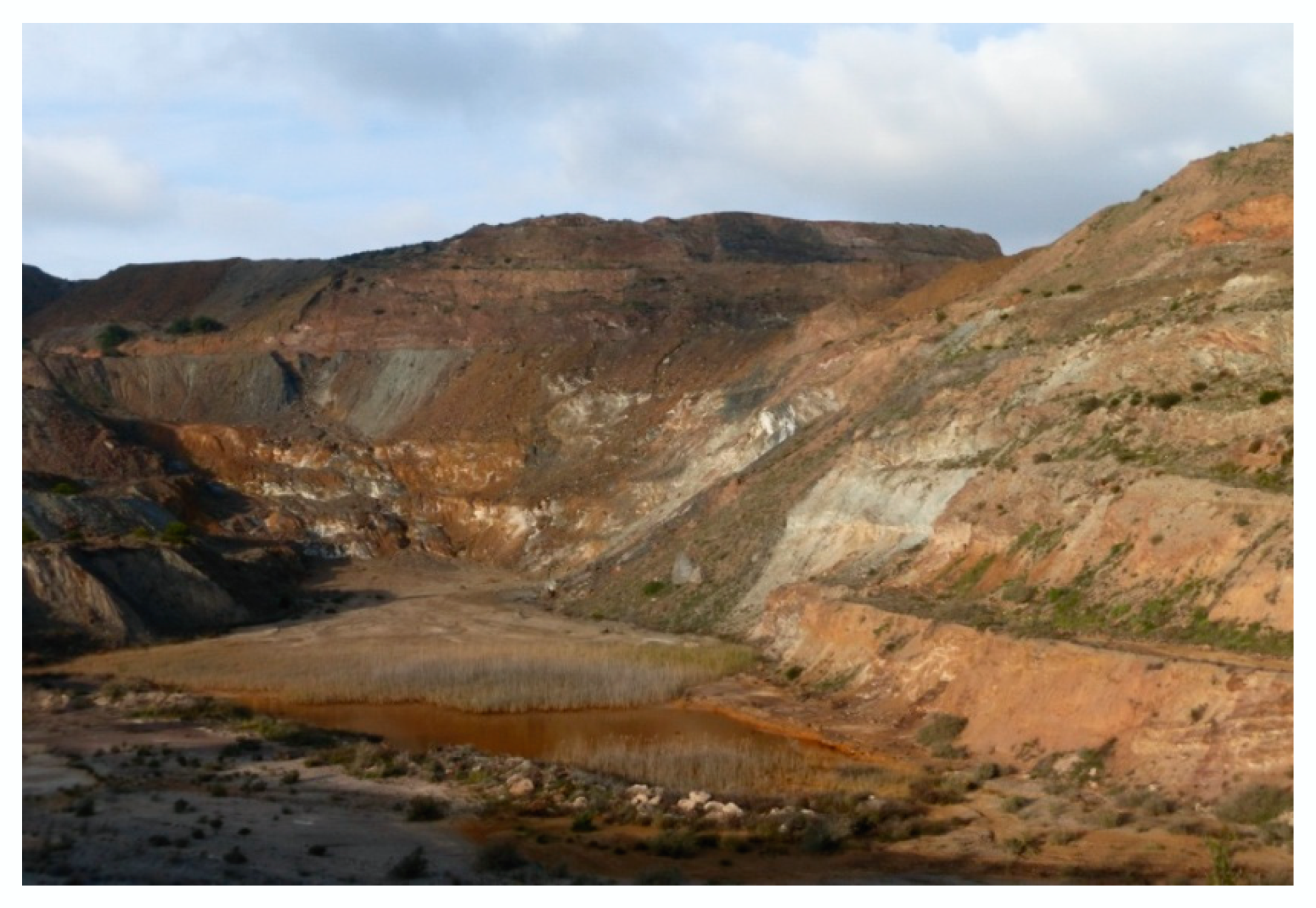
Figure 2.
Specific quarry in the Cartagena-La Unión mining area. Municipality of Cartagena. Author: Carlos J. Pardo Abad.
Figure 2.
Specific quarry in the Cartagena-La Unión mining area. Municipality of Cartagena. Author: Carlos J. Pardo Abad.

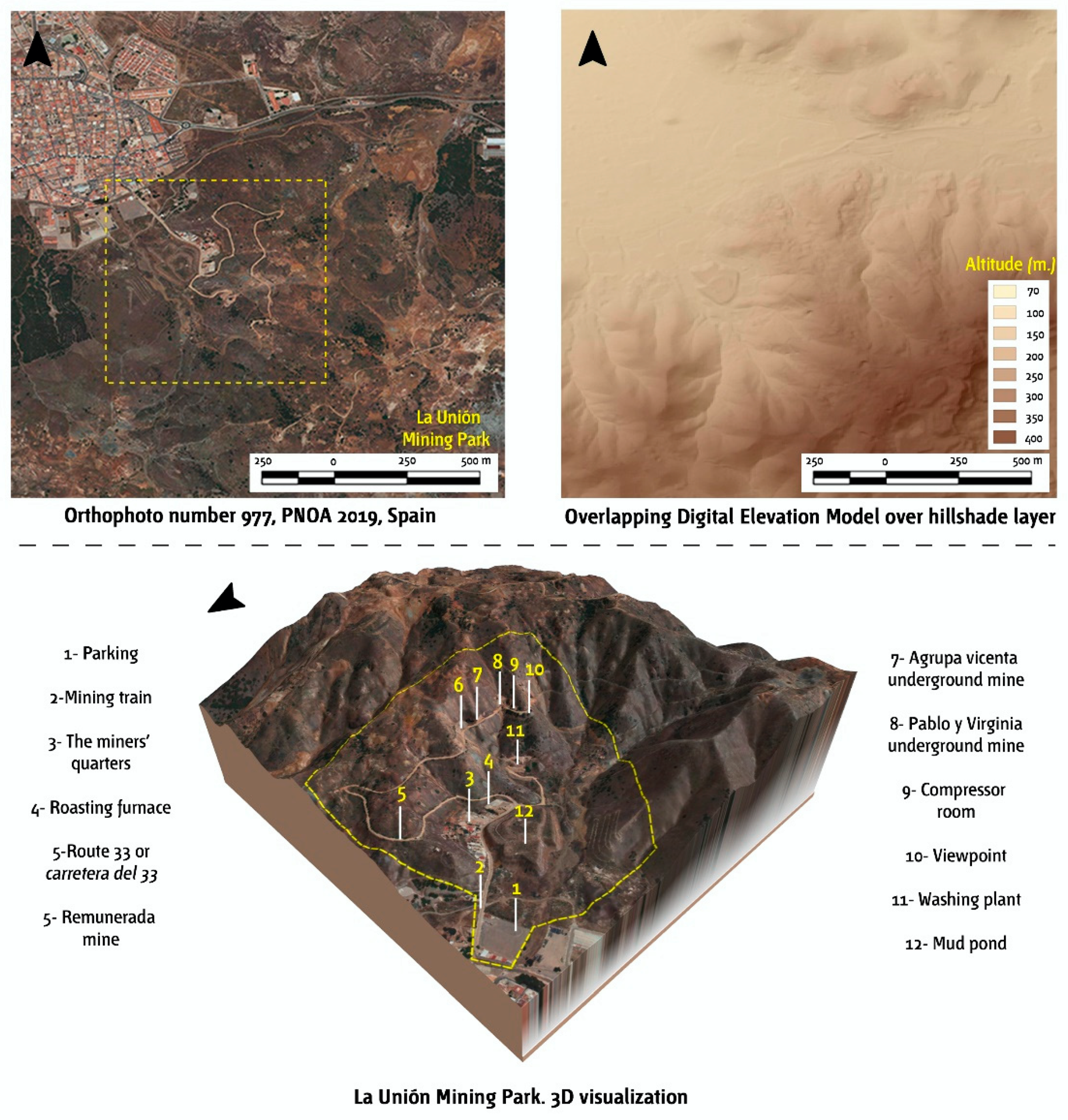
Figure 3.
Digital representations of La Unión Mining Park. Source: own statistics.

Figure 4.
Chimney. Municipality of La Unión. Source: Sierra Minera Foundation [31].
Figure 4.
Chimney. Municipality of La Unión. Source: Sierra Minera Foundation [31].

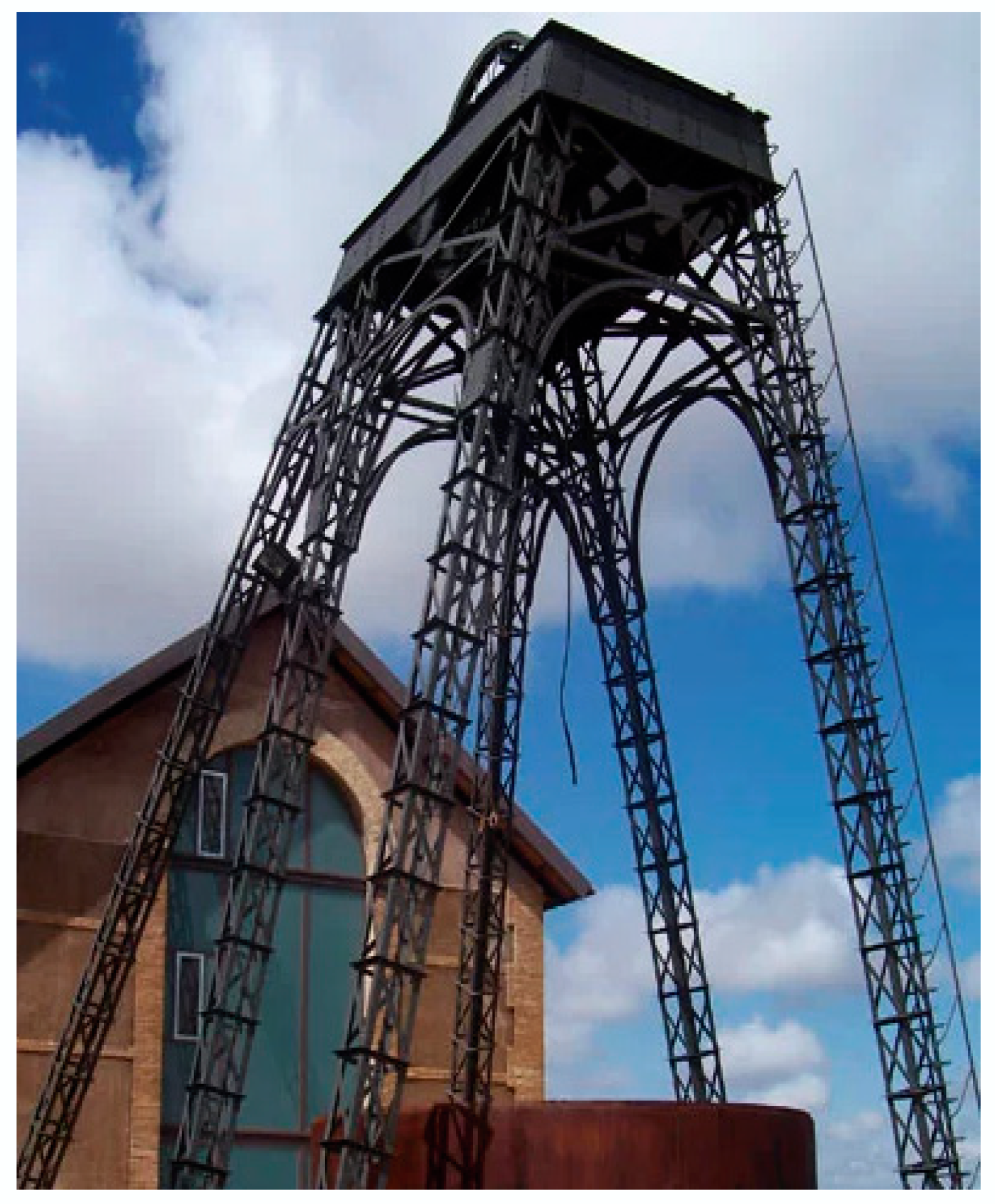
Figure 5.
Entrance to the Agrupa Vicenta mine. Municipality of La Unión. Source: Sierra Minera Foundation [34].
Figure 5.
Entrance to the Agrupa Vicenta mine. Municipality of La Unión. Source: Sierra Minera Foundation [34].

Figure 6.
Shaft tower of the mining area. Municipality of Cartagena. Source: Sierra Minera Foundation [34].
Figure 6.
Shaft tower of the mining area. Municipality of Cartagena. Source: Sierra Minera Foundation [34].

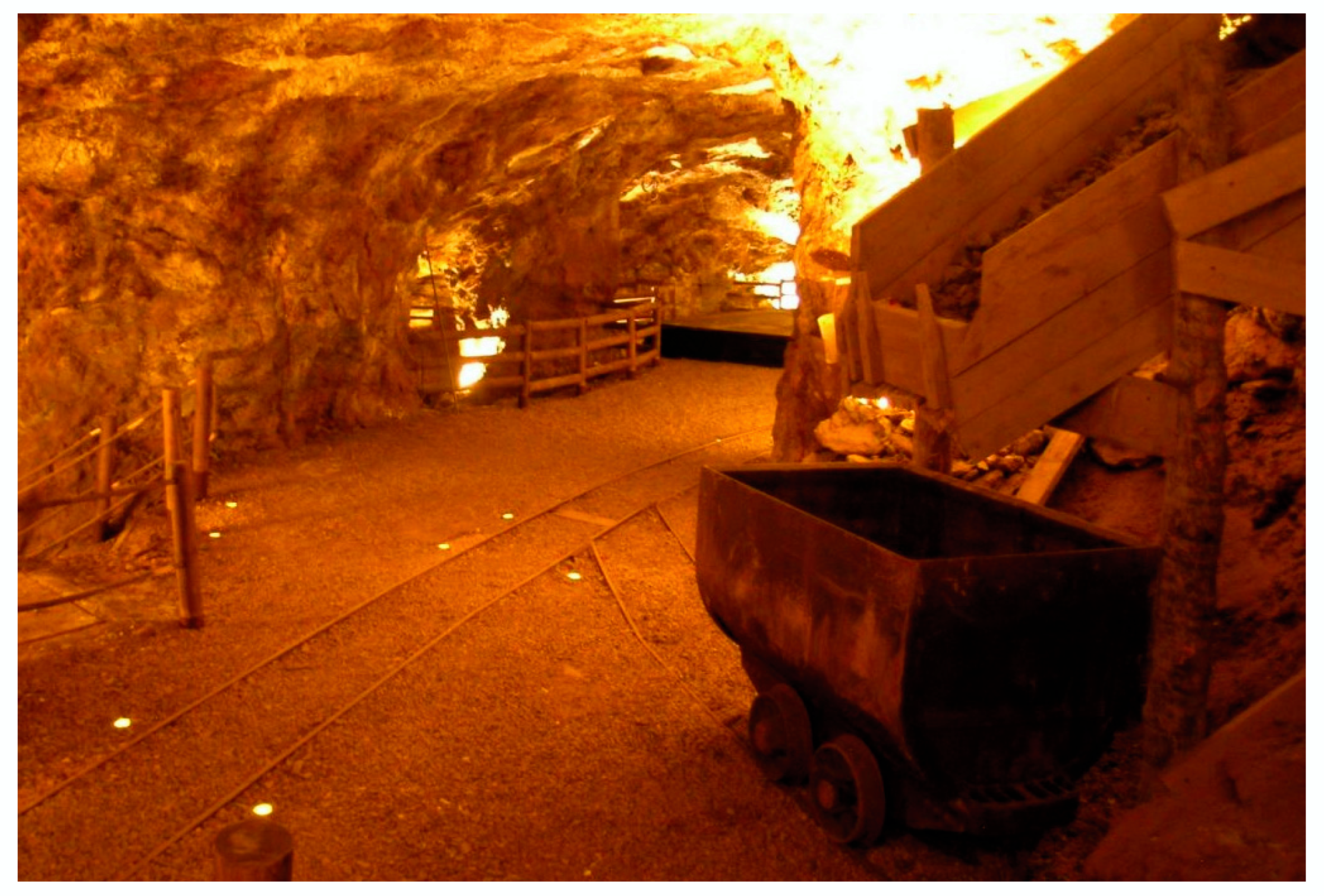
Figure 7.
Inside the Agrupa Vicenta mine. Municipality of La Unión. Source: La Unión Mining Park [28].
Figure 7.
Inside the Agrupa Vicenta mine. Municipality of La Unión. Source: La Unión Mining Park [28].


Table 1.
Landscape analysis form: indicators and groups of indicators.
| Groups of Indicators | Indicators |
|---|---|
| a) Built elements | a.1. Existence of historical or cultural elements of interest. |
| a.2. Presence of unusual constructed or landscape elements of interest to the tourist. | |
| a.3. Aesthetic adaptation of the Mining Park’s tourism infrastructures to the landscape’s unique characteristics. | |
| a.4. Choice of new building designs in accordance with the landscape’s attributes. | |
| a.5. Landscape integration of the different preserved built elements. | |
| b) Landscape environment and scenic quality | b.6. Scenic quality of the mining landscape in the area. |
| b.7. Existence of landscape observation points and representative views. | |
| b.8. Existence of scenic routes between the different preserved elements. | |
| b.9. Uniqueness of the landscape environment. | |
| b.10. Valuation of the color variability of the terrain as an aesthetic resource for tourism. | |
| b.11. Existence of significant visual references: natural landmarks (peaks, mountain ranges, streams, rivers, etc.) | |
| b.12. Existence of significant visual references: artificial landmarks (shaft towers, waste rocks, chimneys, machine rooms, etc.) | |
| b.13. Presence of the place’s scenic and landscape values in the information offered to visitors. | |
| c) Landscape protection and management | c.14. Existence of heritage protection regulations. |
| c.15. Existence of environmental protection. | |
| c.16. Commitment to protect and promote tourism in the mining landscape by the Public Administrations. | |
| c.17. Level of sustainable and smart management of the mining landscape as a tourist resource. | |
| c.18. Presentation and explanation of the landscape values on the Mining Park and Interpretation Centre’s website. | |
| c.19. Presence of 3D models that reproduce to the tourist the landscape features of the mining area. | |
| d) Landscape valuation | d.20. How visitors to the Mining Park and the Interpretation Centre rate the mining landscape and its scenic characteristics. |
| d.21. Valuation of the mining landscape and its scenic features by local population. | |
| d.22. How managers and technical staff rate the mining landscape and its scenic characteristics as a fundamental tourist resource. |
Source: own statistics.
Table 2.
Sectors of the protection zone.
| Sector | Denomination | Surface (ha.) | Surface Percentage | Location |
|---|---|---|---|---|
| Sector I | Cerro de la Parreta de Alumbres | 24.43 | 1.47 | Cartagena |
| Sector II | Cabezo Rajao | 74.41 | 4.47 | Cartagena and La Unión |
| Sector III | Lo Tacón | 2.88 | 0.17 | La Unión |
| Sector IV | Llano del Beal and El Beal | 85.22 | 5.12 | Cartagena |
| Sector V | Camino del 33-Cuesta de Las Lajas | 227.76 | 13.70 | La Unión |
| Sector VI | Rambla del Abenque and Cabezo de la Galera | 286.59 | 17.23 | Cartagena and La Unión |
| Sector VII | Cabezo de Ponce, Peña del Águila and Monte de las Cenizas | 957.63 | 57.59 | Cartagena and La Unión |
| Sector VIII | Lavadero Roberto de Portmán | 4.14 | 0.25 | La Unión |
| Total | 1663.06 | 100 |
Source: Historical Heritage Service of the Murcia Region Government and own information.
Table 3.
Classification levels of the landscape indicators analyzed.
| Indicator Groups | Indicators (see Table 1) | Classification Level * |
|---|---|---|
| a) Built elements | a.1 | 4 |
| a.2 | 4 | |
| a.3 | 5 | |
| a.4 | 5 | |
| a.5 | 5 | |
| Total | 4.6 | |
| b) Landscape environment and scenic quality | b.6 | 5 |
| b.7 | 4 | |
| b.8 | 4 | |
| b.9 | 5 | |
| b.10 | 3 | |
| b.11 | 3 | |
| b.12 | 4 | |
| b.13 | 5 | |
| Total | 4.1 | |
| c) Landscape protection and management | c.14 | 5 |
| c.15 | 4 | |
| c.16 | 4 | |
| c.17 | 4 | |
| c.18 | 5 | |
| c.19 | 3 | |
| Total | 4.2 | |
| a) Landscape valuation | d.20 | 5 |
| d.21 | 4 | |
| d.22 | 5 | |
| Total | 4.7 | |
| Synthetic index of landscape valuation (SILV) | a.1 – d.22 | 4.4 |
* Classification levels: 0 Null; 1 Very low; 2 Low; 3 Medium; 4 High; 5 Very high. Source: own information.
Table 4.
Main items of landscape and information digitalization.
| Item | Las Matildes Interpretation Centre | La Unión Mining Park |
|---|---|---|
| 1. Environmental, landscape and architectural interpretation | X | X |
| 2. Digital information of built and natural heritage | X | X |
| 3. Digital information on adapted physical accessibility | X | - |
| 4. Presence of news bulletin board | X | X |
| 5.Availability of information leaflet in Spanish | X | X |
| 6. Availability of information leaflet in English | X | - |
| 7. Visit pricing information | X | X |
| 8. Possibility of online sale | - | X |
| 9. Availability of image gallery | X | X |
| 10. Presence of presentation videos | X | X |
| 11. Presence of digital cartography | X | X |
| 12. Connection to social networks | X | X |
Source: own statistics.
Table 5.
List of the main tourist resources of the Mining Park.
| Name | Description | Level of Tourist Attraction (1) | Valuation According to Some Quantitative Indicators (2) | |
|---|---|---|---|---|
| Agrupa Vicenta mine | The only underground mine in the complex and the main tourist resource. Dedicated to the extraction of pyrite, it is the first mine to be reconfigured as a museum in the Region of Murcia. | Very high | a.1 | 5 |
| a.2 | 3 | |||
| a.4 | 5 | |||
| a.5 | 4 | |||
| b.7 | 4 | |||
| b.11 | 5 | |||
| b.12 | 3 | |||
| Total | 4.1 | |||
| Pablo y Virginia mine | Mine dedicated to the extraction of pyrite, currently presents a partial recovery of some external buildings and part of the access gallery. | High | a.1 | 3 |
| a.2 | 3 | |||
| a.4 | 1 | |||
| a.5 | 4 | |||
| b.7 | 4 | |||
| b.11 | 5 | |||
| b.12 | 1 | |||
| Total | 3.0 | |||
| Remunerada mine | Mine dedicated to the extraction of tin. It has a set of highly interesting facilities with mechanical elements for the separation of the mineral. | High | a.1 | 4 |
| a.2 | 4 | |||
| a.4 | 1 | |||
| a.5 | 4 | |||
| b.7 | 4 | |||
| b.11 | 5 | |||
| b.12 | 1 | |||
| Total | 3.3 | |||
| Carretera del 33 or Route 33 | Legendary route built in 1933. It crosses the Sierra Minera and connects La Unión with Portmán and the Mediterranean Sea. It is the backbone of the entire complex. | Very high | a.1 | 5 |
| a.2 | 4 | |||
| a.4 | 2 | |||
| a.5 | 4 | |||
| b.7 | 5 | |||
| b.11 | 5 | |||
| b.12 | 5 | |||
| Total | 4.3 | |||
(1). According to the technical managers interviewed. (2). According to the criteria established in the methodological section. Source: own information.
Table 6.
Recent evolution of the number of visitors.
| Tourist Resource | 2015 | 2016 | 2017 | 2018 | 2019 | Annual Average Percentage Change | Total Percentage Change |
|---|---|---|---|---|---|---|---|
| Las Matildes Interpretation Centre | 556 | 949 | 1304 | 2280 | 1943 | +42% | +349% |
| La Unión Mining Park | 31,974 | 35,338 | 31,192 | 30,155 | n.a. | −1.5% | −5.7% |
| La Unión Mining Museum | 9320 | 9480 | 9740 | 9893 | 9960 | +1.7% | +6.9% |
Fuente: Tourist Offices of Cartagena and La Unión, and own statistics.
© 2020 by the authors. Licensee MDPI, Basel, Switzerland. This article is an open access article distributed under the terms and conditions of the Creative Commons Attribution (CC BY) license (http://creativecommons.org/licenses/by/4.0/).
Share and Cite
MDPI and ACS Style
Pardo Abad, C.J.; Fernández Álvarez, J. Landscape as Digital Content and a Smart Tourism Resource in the Mining Area of Cartagena-La Unión (Spain). Land 2020, 9, 112. https://0-doi-org.brum.beds.ac.uk/10.3390/land9040112
AMA Style
Pardo Abad CJ, Fernández Álvarez J. Landscape as Digital Content and a Smart Tourism Resource in the Mining Area of Cartagena-La Unión (Spain). Land. 2020; 9(4):112. https://0-doi-org.brum.beds.ac.uk/10.3390/land9040112
Chicago/Turabian StylePardo Abad, Carlos J., and José Fernández Álvarez. 2020. "Landscape as Digital Content and a Smart Tourism Resource in the Mining Area of Cartagena-La Unión (Spain)" Land 9, no. 4: 112. https://0-doi-org.brum.beds.ac.uk/10.3390/land9040112
Note that from the first issue of 2016, this journal uses article numbers instead of page numbers. See further details here.