Multibeam Bathymetry and Distribution of Clay Minerals on Surface Sediments of a Small Bay in Terra Nova Bay, Antarctica

 ,
,
Abstract
:1. Introduction
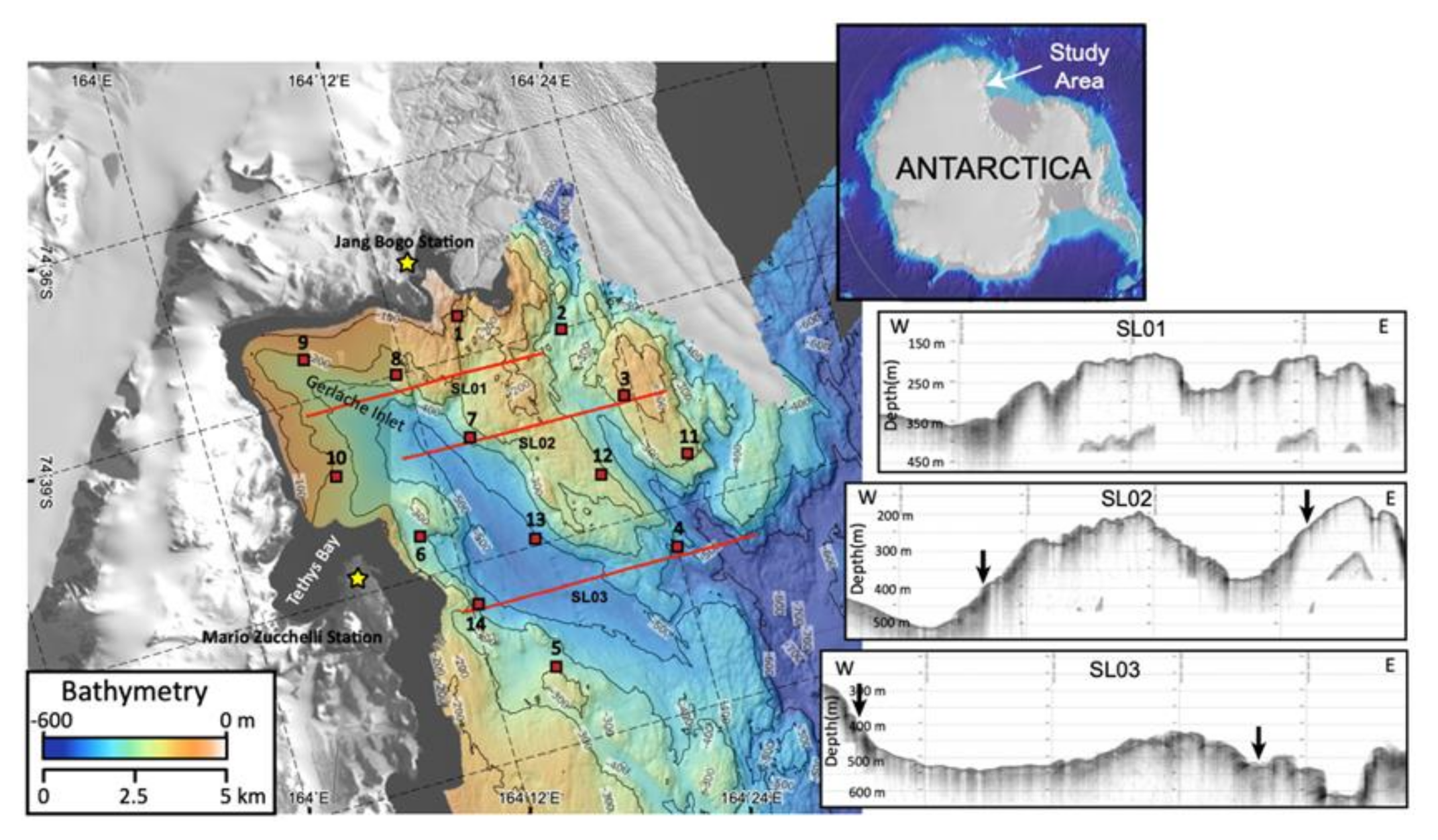
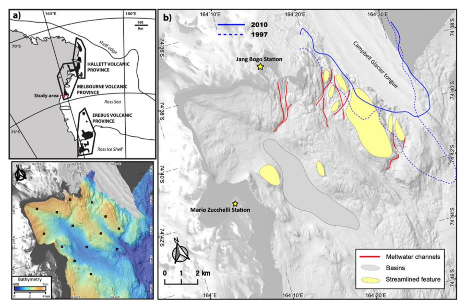
2. Study Area
3. Materials and Methods
3.1. Sampling Locations
3.2. Multibeam Bathymetry and Sub-Bottom Profiles
3.3. Analysis of Grain Size and Clay Mineralogy
4. Results
4.1. Geomorphology
4.2. Granulometric Composition
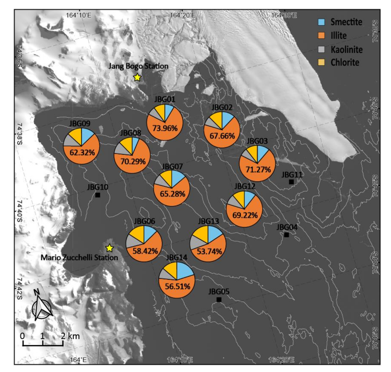
4.3. Semi-Quantification of Clay Minerals and Full Width at Half Maximum of Illite
5. Discussion
6. Conclusions
- The relative abundance of clay minerals in the surface sediments of the study area is largely dominated by illite, reflecting the supply of physical weathering products from the surrounding outcrops. The expandable mineral (smectite and/or mixed layers illite-smectite R0) content is largely high compared to general Antarctic marine sediments, indicative of delivery of products of weathering and erosion of exposed volcanic rocks from the Melbourne Volcanic Province close to the sampling sites.
- Erosional features (streamlined features and meltwater channels) are found near CGT with many coarse-sized components compared with medium sand on till ando/r bedrock except in a deep basin representing a deposition area of fine-sized components in the study area.
- Clastic materials are mainly transported offshore into the sampling site through two agents: icebergs and glacier meltwater. Icebergs detached from the surrounding glaciers mainly deposit the gravel and medium/coarse sand components (>49.1%) on the rugged bedrocks along the edge of CGT and offshore near the coastline of Tethys Bay. When the study area is free from sea ice for about two months in summer, some wind-blown materials (fine sand and silt components) are transported into the sampling sites. Glacier melting occurs in summer, and the clay-sized component of physical weathering products from the surrounding land is deposited along the edge of CGT.
Author Contributions
Funding
Institutional Review Board Statement
Informed Consent Statement
Data Availability Statement
Conflicts of Interest
References
- Rignot, E.; Jacobs, S.; Mouginot, J.; Scheuchl, B. Ice-shelf melting around Antarctica. Science 2013, 341, 266–270. [Google Scholar] [CrossRef] [PubMed] [Green Version]
- Howat, I.M.; Domack, E.W. Reconstructions of western Ross Sea palaeo-ice-stream grounding zones from high-resolution acoustic stratigraphy. Boreas 2003, 32, 56–75. [Google Scholar] [CrossRef]
- Anderson, J.B.; Conway, H.; Bart, P.J.; Witus, A.E.; Greenwood, S.L.; McKay, R.M.; Hall, B.L.; Ackert, R.P.; Licht, K.; Jakobsson, M. Ross Sea paleo-ice sheet drainage and deglacial history during and since the LGM. Quat. Sci. Rev. 2014, 100, 31–54. [Google Scholar] [CrossRef] [Green Version]
- Domack, E.W.; Jacobson, E.A.; Shipp, S.; Anderson, J.B. Late Pleistocene–Holocene retreat of the West Antarctic Ice-Sheet system in the Ross Sea: Part 2—Sedimentologic and stratigraphic signature. Geol. Soc. Am. Bull. 1999, 111, 1517–1536. [Google Scholar] [CrossRef]
- Setti, M.; Marinoni, L.; Lopez-Galindo, A. Mineralogical and geochemical characteristics (major, minor, trace elements and REE) of detrital and authigenic clay minerals in a Cenozoic sequence from Ross Sea, Antarctica. Clay Miner. 2004, 39, 405–421. [Google Scholar] [CrossRef]
- Di Nicola, L.; Strasky, S.; Schlüchter, C.; Salvatore, M.C.; Akçar, N.; Kubik, P.W.; Christl, M.; Kasper, H.U.; Wieler, R.; Baroni, C. Multiple cosmogenic nuclides document complex Pleistocene exposure history of glacial drifts in Terra Nova Bay (northern Victoria Land, Antarctica). Quat. Res. 2009, 71, 83–92. [Google Scholar] [CrossRef]
- Orombelli, G. Terra Nova Bay: A geographic overview. Mem. Della Soc. Geol. Ital. 1987, 33, 69–75. [Google Scholar]
- Baroni, C.; Noti, V.; Ciccacci, S.; Righini, G.; Salvatore, M.C. Fluvial origin of the valley system in northern Victoria Land (Antarctica) from quantitative geomorphic analysis. Geol. Soc. Am. Bull. 2005, 117, 212–228. [Google Scholar] [CrossRef]
- Mosola, A.B.; Anderson, J.B. Expansion and rapid retreat of the West Antarctic Ice Sheet in eastern Ross Sea: Possible consequence of over-extended ice streams? Quat. Sci. Rev. 2006, 25, 2177–2196. [Google Scholar] [CrossRef]
- Halberstadt, A.R.W.; Simkins, L.M.; Greenwood, S.L.; Anderson, J.B. Past ice-sheet behaviour: Retreat scenarios and changing controls in the Ross Sea, Antarctica. Cryosphere 2016, 10, 1003–1020. [Google Scholar] [CrossRef] [Green Version]
- Lee, J.I.; McKay, R.M.; Golledge, N.R.; Yoon, H.I.; Yoo, K.-C.; Kim, H.J.; Hong, J.K. Widespread persistence of expanded East Antarctic glaciers in the southwest Ross Sea during the last deglaciation. Geology 2017, 45, 403–406. [Google Scholar] [CrossRef]
- Shipp, S.; Anderson, J.B. Drumlin field on the Ross Sea continental shelf, Antarctica. In Glaciated Continental Margins; Springer: Berlin/Heidelberg, Germany, 1997; pp. 52–53. [Google Scholar]
- Dowdeswell, J.; Ottesen, D.; Evans, J.; Cofaigh, C.; Anderson, J. Submarine glacial landforms and rates of ice-stream collapse. Geology 2008, 36, 819–822. [Google Scholar] [CrossRef]
- Cooper, A.K.; Barrett, P.J.; Hinz, K.; Traube, V.; Letichenkov, G.; Stagg, H.M. Cenozoic prograding sequences of the Antarctic continental margin: A record of glacio-eustatic and tectonic events. Mar. Geol. 1991, 102, 175–213. [Google Scholar]
- De Santis, L.; Prato, S.; Brancolini, G.; Lovo, M.; Torelli, L. The Eastern Ross Sea continental shelf during the Cenozoic: Implications for the West Antarctic ice sheet development. Glob. Planet. Chang. 1999, 23, 173–196. [Google Scholar] [CrossRef]
- Salvini, F.; Brancolini, G.; Busetti, M.; Storti, F.; Mazzarini, F.; Coren, F. Cenozoic geodynamics of the Ross Sea region, Antarctica: Crustal extension, intraplate strike-slip faulting, and tectonic inheritance. J. Geophys. Res. Solid Earth 1997, 102, 24669–24696. [Google Scholar] [CrossRef]
- Greenwood, S.L.; Gyllencreutz, R.; Jakobsson, M.; Anderson, J.B. Ice-flow switching and East/West Antarctic Ice Sheet roles in glaciation of the western Ross Sea. Bulletin 2012, 124, 1736–1749. [Google Scholar] [CrossRef]
- Brunt, K.M.; Fricker, H.A.; Padman, L.; Scambos, T.A.; O’Neel, S. Mapping the grounding zone of the Ross Ice Shelf, Antarctica, using ICESat laser altimetry. Ann. Glaciol. 2010, 51, 71–79. [Google Scholar] [CrossRef] [Green Version]
- Hillenbrand, C.-D.; Grobe, H.; Diekmann, B.; Kuhn, G.; Fütterer, D.K. Distribution of clay minerals and proxies for productivity in surface sediments of the Bellingshausen and Amundsen seas (West Antarctica)–Relation to modern environmental conditions. Mar. Geol. 2003, 193, 253–271. [Google Scholar] [CrossRef]
- Jung, J.; Yoo, K.-C.; Lee, K.-H.; Park, Y.K.; Lee, J.I.; Kim, J. Clay mineralogical characteristics of sediments deposited during the late quaternary in the Larsen ice shelf B embayment, Antarctica. Minerals 2019, 9, 12. [Google Scholar] [CrossRef] [Green Version]
- Park, Y.K.; Lee, J.I.; Jung, J.; Hillenbrand, C.-D.; Yoo, K.-C.; Kim, J. Elemental compositions of smectites reveal detailed sediment provenance changes during glacial and interglacial periods: The Southern Drake Passage and Bellingshausen Sea, Antarctica. Minerals 2019, 9, 322. [Google Scholar] [CrossRef] [Green Version]
- Chamley, H. Clay Sedimentology; Springer: New York, NY, USA, 2013. [Google Scholar]
- Petschick, R.; Kuhn, G.; Gingele, F. Clay mineral distribution in surface sediments of the South Atlantic: Sources, transport, and relation to oceanography. Mar. Geol. 1996, 130, 203–229. [Google Scholar] [CrossRef] [Green Version]
- Ehrmann, W.U.; Melles, M.; Kuhn, G.; Grobe, H. Significance of clay mineral assemblages in the Antarctic Ocean. Mar. Geol. 1992, 107, 249–273. [Google Scholar] [CrossRef] [Green Version]
- Hong, S.; Lee, M.K.; Seong, Y.B.; Owen, L.A.; Rhee, H.H.; Lee, J.I.; Yoo, K.-C. Holocene sea-level history and tectonic implications derived from luminescence dating of raised beaches in Terra Nova Bay, Antarctica. Geosci. J. 2020, 1–16. [Google Scholar] [CrossRef]
- Han, H.; Lee, H. Tide deflection of Campbell Glacier Tongue, Antarctica, analyzed by double-differential SAR interferometry and finite element method. Remote Sens. Environ. 2014, 141, 201–213. [Google Scholar] [CrossRef]
- Jones, K.; McCave, I.; Patel, D. A computer-interfaced sedigraph for modal size analysis of fine-grained sediment. Sedimentology 1988, 35, 163–172. [Google Scholar] [CrossRef]
- Jung, J.; Yoo, K.-C.; Rosenheim, B.E.; Conway, T.M.; Lee, J.I.; Yoon, H.I.; Hwang, C.Y.; Yang, K.; Subt, C.; Kim, J. Microbial Fe (III) reduction as a potential iron source from Holocene sediments beneath Larsen Ice Shelf. Nat. Commun. 2019, 10, 1–10. [Google Scholar]
- Biscaye, P.E. Distinction between kaolinite and chlorite in recent sediments by X-ray diffraction. Am. Mineral. J. Earth Planet. Mater. 1964, 49, 1281–1289. [Google Scholar]
- Biscaye, P.E. Mineralogy and sedimentation of recent deep-sea clay in the Atlantic Ocean and adjacent seas and oceans. Geol. Soc. Am. Bull. 1965, 76, 803–832. [Google Scholar] [CrossRef]
- Yang, K.; Yoo, K.-C.; Jung, J. Quantitative analysis of asbestos-containing materials using various test methods. Minerals 2020, 10, 568. [Google Scholar] [CrossRef]
- Guggenheim, S.; Bain, D.C.; Bergaya, F.; Brigatti, M.F.; Drits, V.A.; Eberl, D.D.; Formoso, M.L.; Galán, E.; Merriman, R.J.; Peacor, D.R. Report of the Association Internationale pour l′Etude des Argiles (AIPEA) Nomenclature Committee for 2001: Order, disorder and crystallinity in phyllosilicates and the use of the ‘crystallinity index’. Clay Miner. 2002, 37, 389–393. [Google Scholar] [CrossRef]
- Munoz, Y.P.; Wellner, J.S. Seafloor geomorphology of western Antarctic Peninsula bays: A signature of ice flow behaviour. Cryosphere 2018, 12, 205–225. [Google Scholar] [CrossRef] [Green Version]
- Han, H.; Ji, Y.; Lee, H. Estimation of annual variation of ice extent and flow velocity of Campbell Glacier in East Antarctica using COSMO-SkyMed SAR images. Korean J. Remote Sens. 2013, 29, 45–55. [Google Scholar] [CrossRef] [Green Version]
- Guglielmo, L.; Zagami, G.; Saggiomo, V.; Catalano, G.; Granata, A. Copepods in spring annual sea ice at Terra Nova Bay (Ross Sea, Antarctica). Polar Biol. 2007, 30, 747–758. [Google Scholar] [CrossRef]
- Ehrmann, W.; Hillenbrand, C.-D.; Smith, J.A.; Graham, A.G.; Kuhn, G.; Larter, R.D. Provenance changes between recent and glacial-time sediments in the Amundsen Sea embayment, West Antarctica: Clay mineral assemblage evidence. Antarct. Sci. 2011, 23, 471–486. [Google Scholar] [CrossRef] [Green Version]
- Wang, Q.; Yang, S. Clay mineralogy indicates the Holocene monsoon climate in the Changjiang (Yangtze River) Catchment, China. Appl. Clay Sci. 2013, 74, 28–36. [Google Scholar] [CrossRef]
- Sinha, R.; Chatterjee, A. Mineralogy of lacustrine sediments in the Schirmacher range area, eastern Antarctica. J. Geol. Soc. India 2000, 56, 39–46. [Google Scholar]
- Jeong, G.; Yoon, H. The origin of clay minerals in soils of King George Island, South Shetland Islands, West Antarctica, and its implications for the clay-mineral compositions of marine sediments. J. Sediment. Res. 2001, 71, 833–842. [Google Scholar] [CrossRef]
- Jung, J.; Park, Y.; Lee, K.-H.; Hong, J.; Lee, J.; Yoo, K.-C.; Lee, M.; Kim, J. Clay Mineralogical Characteristics and Origin of Sediments Deposited during the Pleistocene in the Ross Sea, Antarctica. J. Mineral. Soc. Korea 2019, 32, 163–172. [Google Scholar] [CrossRef]
- Salvi, C.; Busetti, M.; Marinoni, L.; Brambati, A. Late Quaternary glacial marine to marine sedimentation in the Pennell Trough (Ross Sea, Antarctica). Palaeogeogr. Palaeoclimatol. Palaeoecol. 2006, 231, 199–214. [Google Scholar] [CrossRef]
- Ehrmann, W.; Setti, M.; Marinoni, L. Clay minerals in Cenozoic sediments off Cape Roberts (McMurdo Sound, Antarctica) reveal palaeoclimatic history. Palaeogeogr. Palaeoclimatol. Palaeoecol. 2005, 229, 187–211. [Google Scholar] [CrossRef]
- Ehrmann, W. Lower Miocene and Quaternary clay mineral assemblages from CRP-1. Terra Antart. 1998, 5, 613–619. [Google Scholar]
- Perri, F.; Critelli, S.; Cavalcante, F.; Mongelli, G.; Dominici, R.; Sonnino, M.; De Rosa, R. Provenance signatures for the Miocene volcaniclastic succession of the Tufiti di Tusa Formation, southern Apennines, Italy. Geol. Mag. 2012, 149, 423–442. [Google Scholar] [CrossRef]
- Cavalcante, F.; Fiore, S.; Piccarreta, G.; Tateo, F. Geochemical and mineralogical approaches to assessing provenance and deposition of shales: A case study. Clay Miner. 2003, 38, 383–397. [Google Scholar] [CrossRef]
- Buffoni, G.; Cappelletti, A.; Picco, P. An investigation of thermohaline circulation in Terra Nova Bay polynya. Antarct. Sci. 2002, 14, 83. [Google Scholar] [CrossRef]
- Livingstone, S.J.; Cofaigh, C.Ó.; Stokes, C.R.; Hillenbrand, C.-D.; Vieli, A.; Jamieson, S.S. Glacial geomorphology of Marguerite Bay palaeo-ice stream, western Antarctic Peninsula. J. Maps 2013, 9, 558–572. [Google Scholar] [CrossRef] [Green Version]
- Postma, G. Classification for sediment gravity-flow deposits based on flow conditions during sedimentation. Geology 1986, 14, 291–294. [Google Scholar] [CrossRef]
- Chewings, J.M.; Atkins, C.B.; Dunbar, G.B.; Golledge, N.R. Aeolian sediment transport and deposition in a modern high-latitude glacial marine environment. Sedimentology 2014, 61, 1535–1557. [Google Scholar] [CrossRef]
- Rhee, H.H.; Lee, M.K.; Seong, Y.B.; Hong, S.; Lee, J.I.; Yoo, K.-C.; Yu, B.Y. Timing of the local last glacial maximum in Terra Nova Bay, Antarctica defined by cosmogenic dating. Quat. Sci. Rev. 2019, 221, 105897. [Google Scholar] [CrossRef]
- Pensieri, S.; Bozzano, R.; Schiano, M.E.; Pensieri, L.; Traverso, F.; Trucco, A.; Picco, P.; Bordone, A. Environmental acoustic noise observations in Tethys Bay (Terra Nova Bay, Ross Sea, Antarctica). In Proceedings of the 2014 Oceans-St. John’s, St. John’s, NL, Canada, 14–19 September 2014; pp. 1–6. [Google Scholar]


| Sampling Site | Latitude (S) | Longitude (E) | Water Depth (m) | Type of Sample |
|---|---|---|---|---|
| JBG01 | 74°38.40 | 164°15.60 | 150 | Sediment |
| JBG02 | 74°39.00 | 164°21.00 | 390 | Sediment |
| JBG03 | 74°40.20 | 164°23.40 | 225 | Sediment |
| JBG04 | 74°42.60 | 164°24.00 | 523 | Sediment |
| JBG05 | 74°43.80 | 164°15.60 | 328 | Rocky bottom |
| JBG06 | 74°41.40 | 164°10.20 | 386 | Sediment |
| JBG07 | 74°40.20 | 164°14.40 | 390 | Sediment |
| JBG08 | 74°39.00 | 164°11.40 | 255 | Sediment |
| JBG09 | 74°38.40 | 164°06.60 | 230 | Rocky bottom |
| JBG10 | 74°40.20 | 164°06.60 | 235 | Sediment |
| JBG11 | 74°41.27 | 164°25.93 | 280 | Rocky bottom |
| JBG12 | 74°41.25 | 164°20.99 | 270 | Sediment |
| JBG13 | 74°41.90 | 164°16.44 | 515 | Sediment |
| JBG14 | 74°42.60 | 164°12.37 | 388 | Sediment |
| Sampling Site | Gravel (%) | Sand (%) | Silt (%) | Clay (%) | Gravel + Coarse/Medium Sand (%) | Mean Size (φ) | Sorting (φ) |
|---|---|---|---|---|---|---|---|
| JBG01 | 0.2 | 89.9 | 5.2 | 4.7 | 10.1 | 3.0 | 1.4 |
| JBG02 | 6.2 | 88.1 | 2.8 | 2.9 | 49.1 | 1.9 | 1.8 |
| JBG03 | 35.4 | 61.0 | 1.4 | 2.5 | 68.3 | 0.5 | 2.4 |
| JBG04 | 0.1 | 99.5 | 0.1 | 0.2 | 73.6 | 1.7 | 0.7 |
| JBG06 | 3.2 | 95.0 | 0.6 | 1.2 | 32.5 | 2.4 | 1.1 |
| JBG07 | 0.6 | 90.1 | 3.7 | 5.6 | 13.3 | 3.2 | 1.7 |
| JBG08 | 0.0 | 87.5 | 7.2 | 5.3 | 9.6 | 3.2 | 1.5 |
| JBG10 | 0.0 | 91.9 | 1.4 | 6.7 | 5.3 | 3.2 | 1.6 |
| JBG12 | 0.1 | 97.2 | 1.0 | 1.8 | 24.5 | 2.5 | 0.9 |
| JBG13 | 0.0 | 73.0 | 10.0 | 17.0 | 9.3 | 5.1 | 3.2 |
| JBG14 | 0.0 | 95.9 | 1.3 | 2.7 | 15.8 | 2.8 | 0.8 |
| Sampling Site | Smectite (%) | Illite (%) | Kaolinite (%) | Chlorite (%) | FWHM (°Δ2θ) |
|---|---|---|---|---|---|
| JBG01 | 8.6 | 74.0 | 7.5 | 10.0 | 0.49 |
| JBG02 | 12.0 | 67.7 | 7.8 | 12.6 | 0.52 |
| JBG03 | 11.2 | 71.3 | 7.0 | 10.6 | 0.49 |
| JBG06 | 12.7 | 58.4 | 13.0 | 15.9 | 0.43 |
| JBG07 | 13.8 | 65.3 | 9.3 | 11.6 | 0.48 |
| JBG08 | 6.5 | 70.3 | 10.9 | 12.4 | 0.41 |
| JBG09 | 12.9 | 62.3 | 11.7 | 13.2 | 0.47 |
| JBG12 | 10.6 | 69.2 | 9.1 | 11.1 | 0.42 |
| JBG13 | 15.7 | 53.7 | 13.8 | 16.8 | 0.40 |
| JBG14 | 20.1 | 56.5 | 9.6 | 13.8 | 0.54 |
| Avg. | 12.3 | 64.6 | 10.0 | 12.8 | 0.47 |
Publisher’s Note: MDPI stays neutral with regard to jurisdictional claims in published maps and institutional affiliations. |
© 2021 by the authors. Licensee MDPI, Basel, Switzerland. This article is an open access article distributed under the terms and conditions of the Creative Commons Attribution (CC BY) license (http://creativecommons.org/licenses/by/4.0/).
Share and Cite
Jung, J.; Ko, Y.; Lee, J.; Yang, K.; Park, Y.K.; Kim, S.; Moon, H.; Kim, H.J.; Yoo, K.-C. Multibeam Bathymetry and Distribution of Clay Minerals on Surface Sediments of a Small Bay in Terra Nova Bay, Antarctica. Minerals 2021, 11, 72. https://0-doi-org.brum.beds.ac.uk/10.3390/min11010072
Jung J, Ko Y, Lee J, Yang K, Park YK, Kim S, Moon H, Kim HJ, Yoo K-C. Multibeam Bathymetry and Distribution of Clay Minerals on Surface Sediments of a Small Bay in Terra Nova Bay, Antarctica. Minerals. 2021; 11(1):72. https://0-doi-org.brum.beds.ac.uk/10.3390/min11010072
Chicago/Turabian StyleJung, Jaewoo, Youngtak Ko, Joohan Lee, Kiho Yang, Young Kyu Park, Sunghan Kim, Heungsoo Moon, Hyoung Jun Kim, and Kyu-Cheul Yoo. 2021. "Multibeam Bathymetry and Distribution of Clay Minerals on Surface Sediments of a Small Bay in Terra Nova Bay, Antarctica" Minerals 11, no. 1: 72. https://0-doi-org.brum.beds.ac.uk/10.3390/min11010072