
Tin and Bronze Production at the Outeiro de Baltar Hillfort (NW Iberia)

 , ,
, ,  ,
,  ,
,  , , , , , and
Abstract
:1. Introduction
2. Materials and Techniques
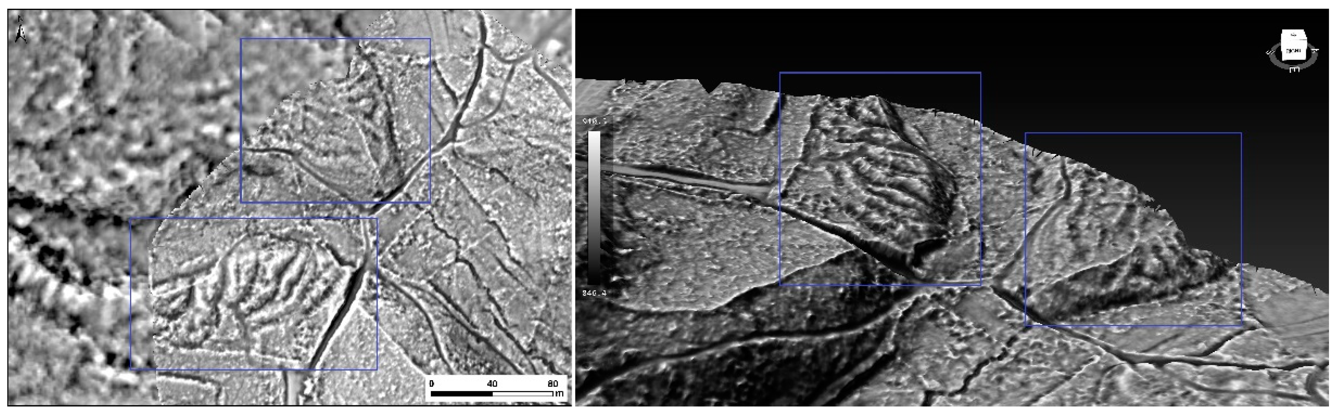
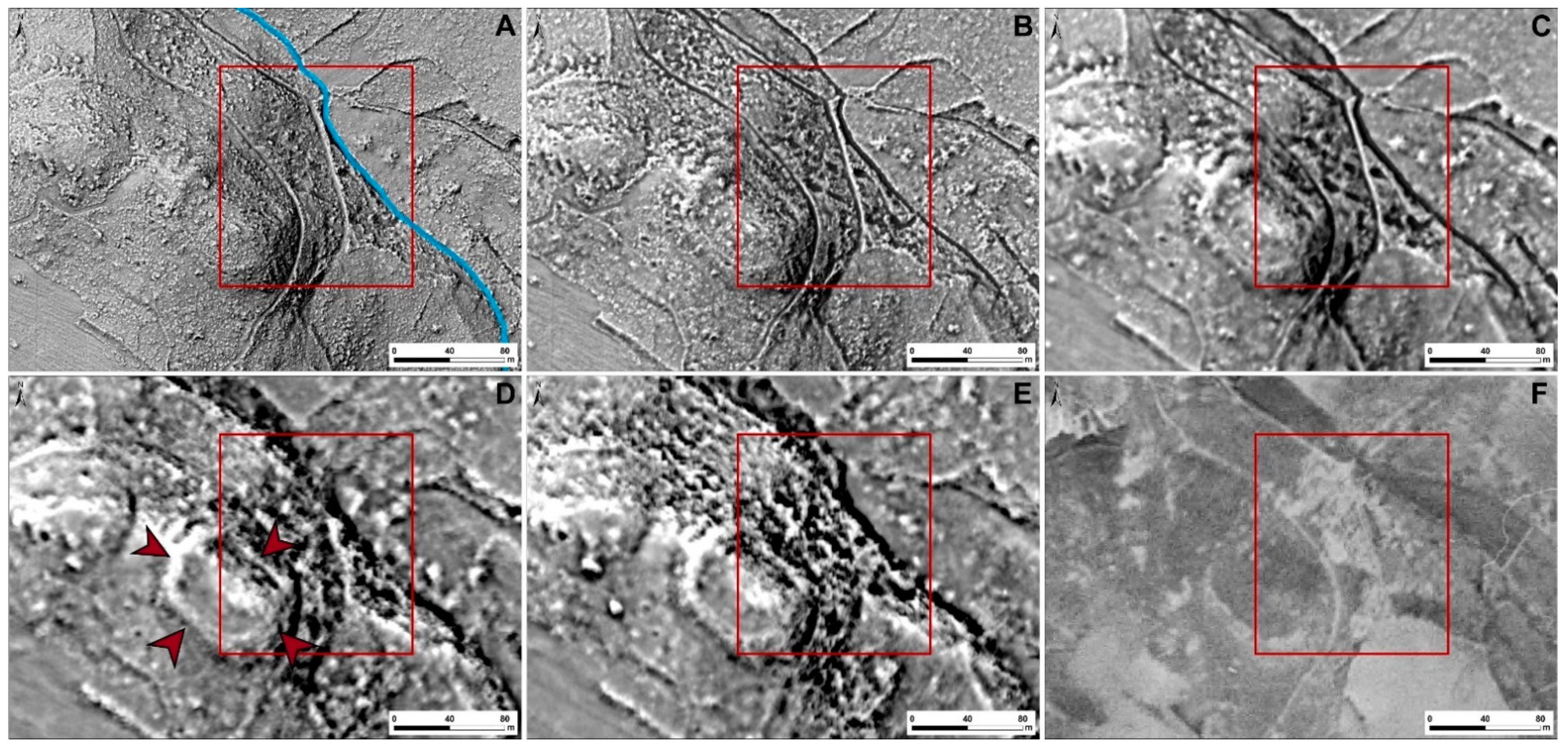
2.1. Remote Sensing
2.2. Archaeological Materials
2.3. Set of Cassiterite Crystal Samples
2.4. Digital Optical Microscopy
2.5. pXRF
2.6. WDXRF
2.7. Micro-XRF
2.8. SEM-EDS
3. Results and Discussion
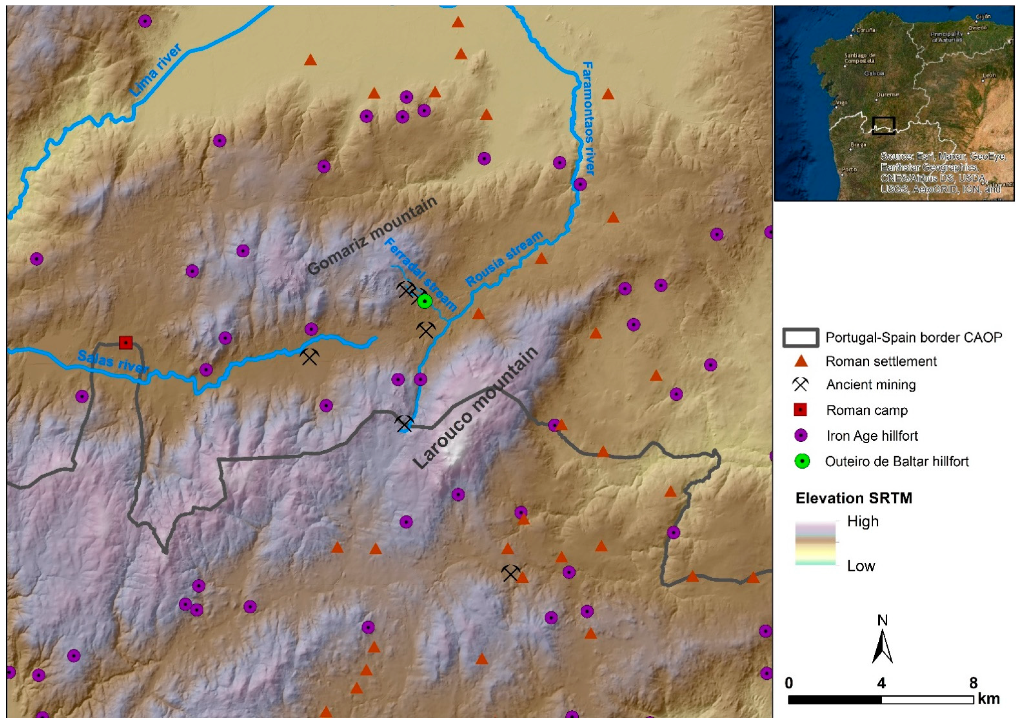
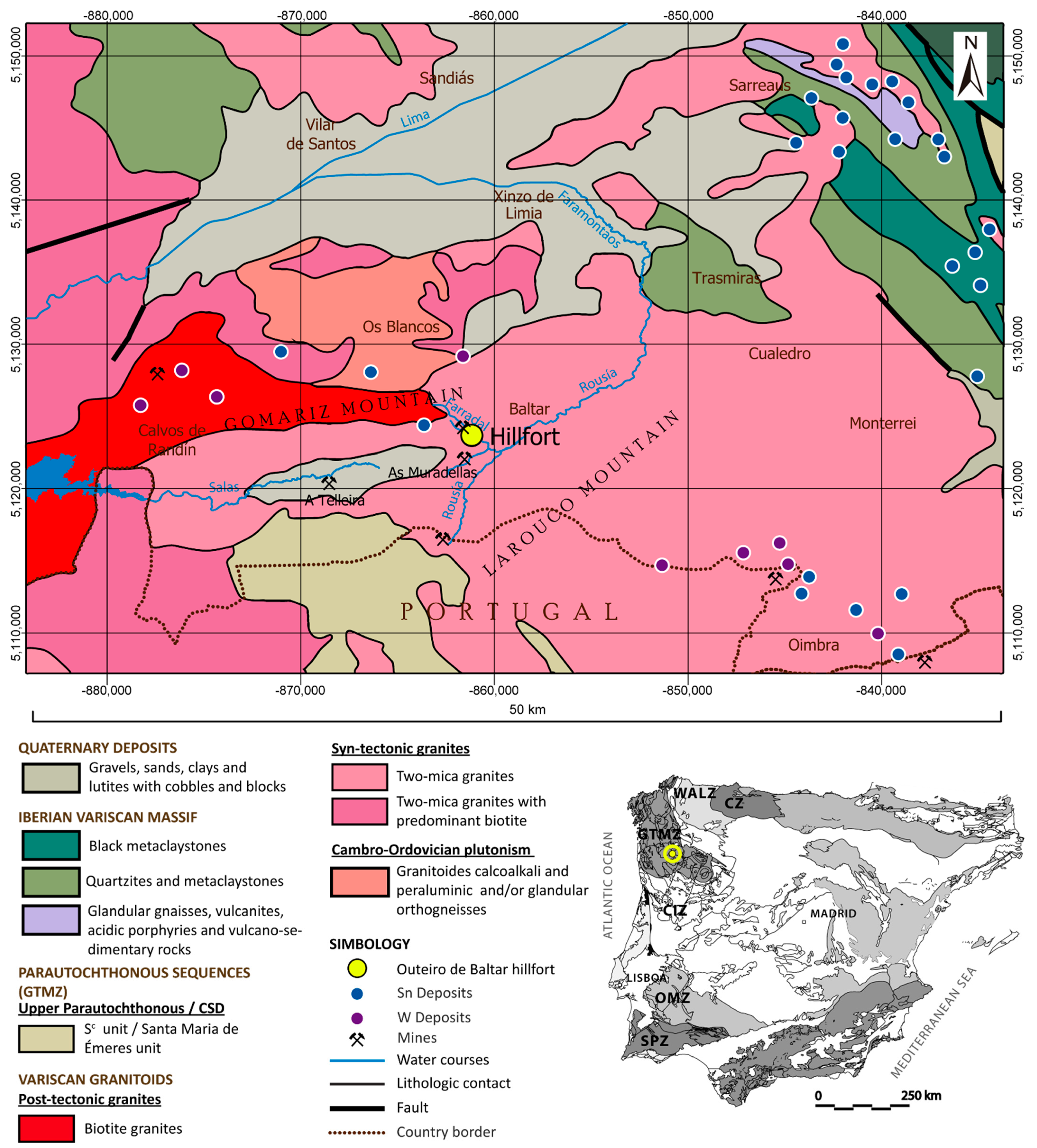
3.1. The Mining Landscape
3.2. Archaeological Materials
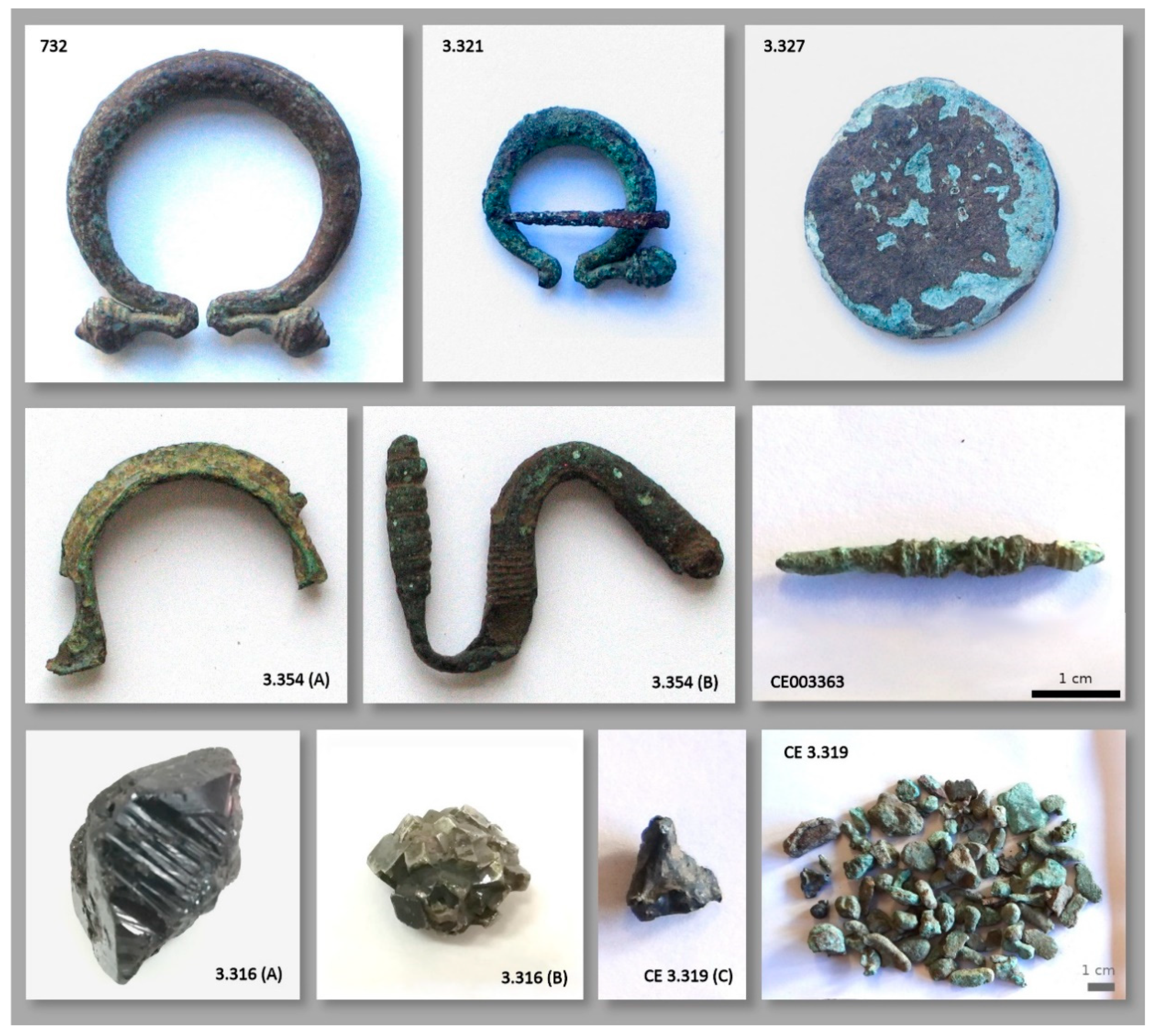
3.2.1. Metal Artefacts and Lithic Tools
3.2.2. Slag, Metal Debris and Ores
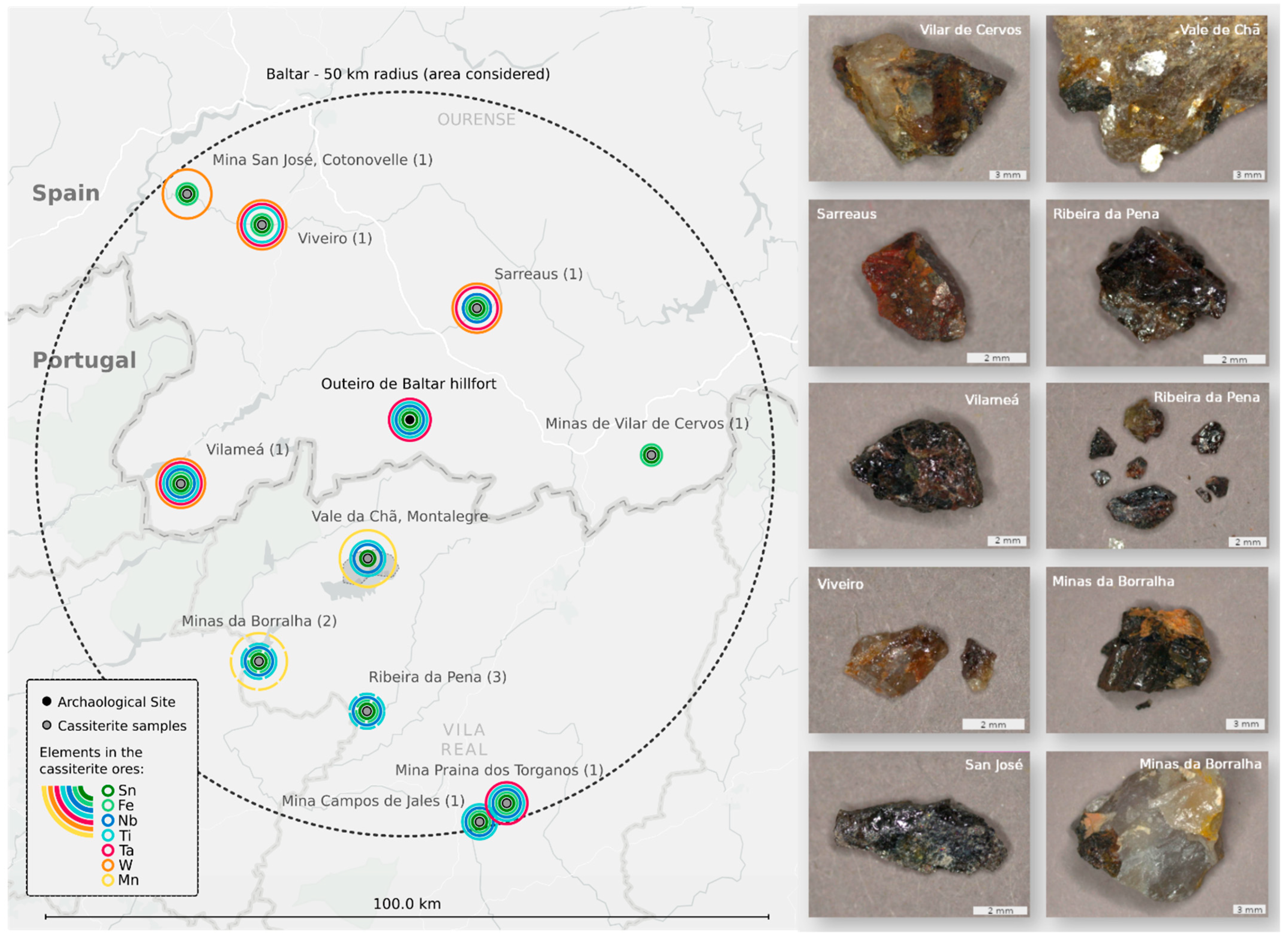
3.3. Set of Cassiterite Samples from the Region and Collected Sediments
4. Conclusions
Author Contributions
Funding
Institutional Review Board Statement
Informed Consent Statement
Data Availability Statement
Acknowledgments
Conflicts of Interest
References
- Catalogación do Patrimonio Cultural da Alta Limia, Fundación Barrié. Museo Arqueolóxico Provincial de Ourense. Grupo Marcelo Macías. Xunta da Galicia. Available online: http://www.altalimia.org/ (accessed on 4 April 2022).
- Rodríguez Galdo, M.X.; Losada Álvarez, A. El ciclo de creación de empresas mineras en Galicia vinculado a la demanda internacional de volfram. In Proceedings of the VIII Congreso de la Asociación Española de Historia Económica, Santiago de Compostela, Spain, 13–16 September 2005; pp. 1–21. [Google Scholar]
- López Cuevillas, F.; Taboada Chivite, J. Una estación galaico-romana en el Outeiro de Baltar. Arch. Español Arqueol. 1946, 63, 117–130. [Google Scholar]
- López Cuevillas, F. Nuevos hallazgos en Outeiro de Baltar. Cuad. Estudios Gallegos 1958, 3, 314–320. [Google Scholar]
- Cavada-Nieto, M. Hallazgos monetarios en castros de Galicia. Boletín Del Semin. Estud. Arte Arqueol. 1972, 38, 211–248. [Google Scholar]
- Vázquez Rodríguez, C. Crónica del museo. Restos del castro de Outeiro de Baltar. Boletín Mus. Arqueol. Ourense 1943, 1, 121–122. [Google Scholar]
- Figueiredo, E.; Fonte, J.; Lima, A.; Veiga, J.P.; Silva, R.; Mirão, J. Ancient tin production: Slags from the Iron Age Carvalhelhos hillfort (NW Iberian Peninsula). J. Archaeol. Sci. 2018, 93, 1–16. [Google Scholar] [CrossRef] [Green Version]
- Fonte, J.; Lima, A.; Matías-Rodríguez, R.; Gonçalves, J.A.; Leal, S. Novas evidências de mineração aurífera e estanhífera de época Romana no alto vale do Tâmega (Montalegre e Boticas, Norte de Portugal). Estud. Quaternário 2017, 17, 45–55. [Google Scholar] [CrossRef] [Green Version]
- Fonte, J.; Meunier, E.; Gonçalves, J.A.; Dias, F.; Lima, A.; Gonçalves-Seco, L.; Figueiredo, E. An Integrated Remote-Sensing and GIS Approach for Mapping Past Tin Mining Landscapes in Northwest Iberia. Remote Sens. 2021, 13, 3434. [Google Scholar] [CrossRef]
- Instituto Geográfico Nacional. Plan Nacional de Ortofotografía Aérea. Available online: https://pnoa.ign.es/ (accessed on 4 April 2022).
- Hesse, R. LiDAR-derived Local Relief Models—A new tool for archaeological prospection. Archaeol. Prospect. 2010, 17, 67–72. [Google Scholar] [CrossRef]
- Doneus, M. Openness as Visualization Technique for Interpretative Mapping of Airborne Lidar Derived Digital Terrain Models. Remote Sens. 2013, 5, 6427–6442. [Google Scholar] [CrossRef] [Green Version]
- Kokalj, Ž.; Somrak, M. Why Not a Single Image? Combining Visualizations to Facilitate Fieldwork and On-Screen Mapping. Remote Sens. 2019, 11, 747. [Google Scholar] [CrossRef] [Green Version]
- Zakšek, K.; Oštir, K.; Kokalj, Ž. Sky-View Factor as a Relief Visualization Technique. Remote Sens. 2011, 3, 398–415. [Google Scholar] [CrossRef] [Green Version]
- RapidLasso GmbH. LAStools. Available online: https://rapidlasso.com/lastools/ (accessed on 4 April 2022).
- ZRC SAZU Institute of Anthropological and Spatial Studies. Relief Visualization Toolbox (RVT). Available online: https://iaps.zrc-sazu.si/en/rvt (accessed on 4 April 2022).
- Planlauf GmbH. Planlauf/TERRAIN. Available online: https://planlaufterrain.com/ (accessed on 4 April 2022).
- Pérez, J.A.; Bascon, F.M.; Charro, M.C. Photogrammetric Usage of 1956-57 Usaf Aerial Photography of Spain. Photogramm. Rec. 2014, 29, 108–124. [Google Scholar] [CrossRef]
- Fernández Pompa, F.; Boquera Fillol, J. Hoja 302–BALTAR del Mapa Geológico de España Escala 1:50.000; IGME: Madrid, Spain, 2001. [Google Scholar]
- Noronha, F. Mineralizações. Geonovas 1988, 10, 37–54. [Google Scholar]
- Noronha, F.; Ribeiro, M.A.; Almeida, A.; Dória, A.; Guedes, A.; Lima, A.; Martins, H.C.; Sant’Ovaia, H.; Nogueira, P.; Martins, T.; et al. Jazigos filonianos hidrotermais e aplitopegmatíticos espacialmente associados a granitos (Norte de Portugal). In Geologia de Portugal; Dias, R., Araújo, A., Terrinha, P., Kullberg, J.C., Eds.; Évora University: Évora, Portugal, 2006; Volume 1, pp. 123–135. [Google Scholar]
- Direccion General de Minas. Programa Nacional de Explotacion Minera-Minería de Minerales Metálicos Varios; Internal Report; IGME: Madrid, Spain, 1971. [Google Scholar]
- Rodríguez Fernández, L.R.; López Olmedo, F.; Oliveira, J.T.; Medialdea, T.; Terrinha, P.; Matas, J.; Martín-Serrano, A.; Martín Parra, L.M.; Rubio, F.; Marín, C.; et al. Mapa Geológico de la Península Ibérica, Baleares y Canarias a Escala 1/1.000.000; IGME: Madrid, Spain; LNEG: Lisboa, Portugal, 2015. Available online: https://info.igme.es/cartografiadigital/geologica/ (accessed on 29 January 2021).
- Servizo Galego de saúde; Xunta de Galicia. Ríos y encoros. Xeografía Física. Hidrografía. Available online: https://www.sergas.es/Saude-publica/GIS-Hidrografia (accessed on 3 April 2022).
- LNEG. Sistema de Informação de Ocorrências e Recursos Minerais Portugueses–SIORMINP. Available online: https://geoportal.lneg.pt/pt/bds/siorminp/#!/ (accessed on 4 April 2022).
- IGME. Base de Datos de Indicios o explotaciones de Rocas y Minerales Industriales. Available online: http://mapas.igme.es/Servicios/wms.aspx?lang=spa&url=https://mapas.igme.es/gis/services/BasesDatos/IGME_BDMIN_Explotaciones/MapServer/WMSServer?service=wms__request=getcapabilities__version=1.3.0 (accessed on 4 April 2022).
- IGME. Metodología para la representación gráfica de los datos de infraestructura minera. In Estudio Preliminar y Aplicación al Caso del Estaño y el Volframio; Memoria. Internal Report; IGME: Madrid, Spain, 1982. [Google Scholar]
- Pazos, O. Atopada Outra Gran Mina Romana na Raia a Carón do Impoñente Castro da Boullosa. Blog Historia de Galicia 2021. Available online: https://historiadegalicia.gal/2021/08/atopada-outra-gran-mina-romana-na-raia-a-caron-do-imponente-castro-da-boullosa (accessed on 31 March 2022).
- Figueiredo, E.; Valério, P.; Araújo, M.F.; Senna-Martinez, J.C. Micro-EDXRF surface analyses of a bronze spear head: Lead content in metal and corrosion layers. Nucl. Instrum. Methods Phys. Res. Sect. A 2007, 580, 725–727. [Google Scholar] [CrossRef]
- Centeno, R. Da República ao Império: Reflexões sobre a monetização no ocidente da Hispania. In Barter, Money and Coinage in the Ancient Mediterranean (10th–1st Centuries BC); García-Bellido, M.P., Callegarin, L., Jiménez, A., Eds.; CSIC: Madrid, Spain, 2011; pp. 355–367. [Google Scholar]
- Armada, X.L.; García-Vuelta, O. Plano-convex ingots and precious metalwork in northwestern Iberia during the Late Iron Age and early Roman period: An analytical approach. Archaeol. Anthropol. Sci. 2021, 13, 78. [Google Scholar] [CrossRef]
- Armada, X.L.; García-Vuelta, O. Dating Iron Age goldwork: First direct AMS 14C results from Northwestern Iberia. Trab. Prehist. 2015, 72, 272–282. [Google Scholar] [CrossRef] [Green Version]
- Figueiredo, E.; Araújo, M.F.; Silva, R.J.C.; Vilaça, R. Characterisation of a Proto-historic bronze collection by Micro-EDXRF. Nucl. Instrum. Meth. B 2013, 296, 26–31. [Google Scholar] [CrossRef]
- Figueiredo, E.; Silva, R.J.C.; Senna-Martinez, J.C.; Araújo, M.F.; Braz Fernandes, F.M.; Inês Vaz, J.L. Smelting and Recycling Evidences from the Late Bronze Age Habitat Site of Baiões (Viseu, Portugal). Archaeol. Sci. 2010, 37, 1623–1634. [Google Scholar] [CrossRef]
- Figueiredo, E.; Lackinger, A.; Comendador Rey, B.; Silva, R.J.C.; Veiga, J.P.; Mirão, J. An Experimental Approach for Smelting Tin Ores from Northwestern Iberia. Mater. Manuf. Process. 2017, 32, 765–774. [Google Scholar] [CrossRef] [Green Version]
- Chirikure, S.; Heimann, R.B.; Killick, D. The Technology of Tin Smelting in the Rooiberg Valley, Limpopo Province, South Africa, ca. 1650-1850 CE. J. Archaeol. Sci. 2010, 37, 1656–1669. [Google Scholar] [CrossRef]
- Mahé-le Carlier, C.; Lulzac, Y.; Giot, P.-R. Etude Des Déchets de Réduction Provenant de Deux Sites d’exploitation d’étain Armoricain de l’Age Du Bronze et Du Moyen Age. Rev. Archéol. L’ouest 2001, 18, 45–56. [Google Scholar] [CrossRef]
- Montes-Landa, J.; Montero-Ruiz, I.; Castanyer Masoliver, P.; Santos Retolaza, M.; Tremoleda Trilla, J.; Martinón-Torres, M. Traditions and Innovations: Versatility of Copper and Tin Bronze Making Recipes in Iron Age Emporion (L’Escala, Spain). Archaeol. Anthropol. Sci. 2020, 12, 124. [Google Scholar] [CrossRef]
- Domergue, C. Les Mines Antiques; Picard: Paris, France, 2008. [Google Scholar]
- Monteagudo, L. Metalurgia Hispana de la Edad del Bronce, con especial estudio de Galicia y norte de Portugal. Cesaraugusta 1954, 4, 55–95. [Google Scholar]
- Meunier, E. El estaño del noroeste ibérico desde la Edad del Bronce hasta la época Romana. Por una primera síntesis. In La Ruta de las Estrímnides, Navegación y Conocimento del Litoral Atlántico de Iberia en la Antigüedad; Ferrer Albelda, E., Ed.; Monografías de Gahia 4; Universidad de Alcalá/Universidad de Sevilla: Alcalá de Henares, Spain, 2019; pp. 279–320. [Google Scholar]
- Farci, C.; Martinón-Torres, M.; Álvarez, D.G. Bronze Production in the Iron Age of the Iberian Peninsula: The Case of El Castru, Vigaña (Asturias, NW Spain). J. Archaeol. Sci. Rep. 2017, 11, 338–351. [Google Scholar] [CrossRef]
- Renzi, M. La Fonteta (Guardamar Del Segura, Alicante) y La Metalurgia Fenicia de Época Arcaica En La Península Ibérica/La Fonteta (Guardamar Del Segura, Alicante) and the Phoenician Metallurgy of the Archaic Period in the Iberian Peninsula. Ph.D. Thesis, Universidad Complutense de Madrid, Madrid, Spain, 2012. [Google Scholar]
- Rovira, S.; Renzi, M. Early technologies for metal production in the Iberian Peninsula. Mater. Manuf. Process. 2017, 32, 756–764. [Google Scholar] [CrossRef]
- Valério, P.; Monge Soares, A.M.; Silva, R.J.C.; Araújo, M.F.; Rebelo, P.; Neto, N.; Santos, R.; Fontes, T. Bronze Production in Southwestern Iberian Peninsula: The Late Bronze Age Metallurgical Workshop from Entre Águas 5 (Portugal). J. Archaeol. Sci. 2013, 40, 439–451. [Google Scholar] [CrossRef]
- Antunes, I.M.H.R.; Neiva, A.M.R.; Silva, M.M.V.G. Caracterização Geoquímica de Minerais de Jazigos Da Região de Segura (Castelo Branco). A Geol. Eng. Recur. Geol. 2003, 2, 157–168. [Google Scholar]
- Murciego, A.; Garcla Sanchez, A.; Dusausoy, Y.; Martin Pozas, J.M.; Ruck, R. Geochemistry and EPR of Cassiterites from the Iberian Hercynian Massif. Miner. Mag. 1997, 61, 357–365. [Google Scholar] [CrossRef]
- Neiva, A.M.R. Geochemistry of Cassiterite and Wolframite from Tin and Tungsten Quartz Veins in Portugal. Ore Geol. Rev. 2008, 33, 221–238. [Google Scholar] [CrossRef] [Green Version]


| Item | Inv. Number | Elements Detected | Material Interpretation | ||||||||||
|---|---|---|---|---|---|---|---|---|---|---|---|---|---|
| Cu | Sn | Pb | Ag | As | Ni | Fe | Zn | Sb | Other | ||||
| Pin | 3.363 | +++ | ++ | + | n.d. | n.d. | n.d. | - | n.d. | vest. | Cu-Sn-Pb | Bronze with lead | |
| Terminal | 3.363 | +++ | ++ | + | n.d. | n.d. | - | - | n.d. | n.d. | Cu-Sn-Pb | Bronze with lead | |
| Bar | 3.333 | +++ | ++ | + | n.d. | n.d. | n.d. | - | n.d. | n.d. | Cu-Sn-Pb | Bronze with some lead | |
| Fibula | 732 | +++ | - | - | n.d. | n.d. | n.d. | - | ++ | n.d. | Ca, Ti/Ba | Cu-Zn | Brass |
| Fibula | 3.321 | +++ | + | + | n.d. | n.d. | n.d. | - | ++ | n.d. | Cl, Mn | Cu-Zn | Brass with Sn, Pb |
| Fibula | 3.322 | +++ | - | - | n.d. | n.d. | n.d. | - | + | n.d. | Cu-Zn | Brass with some Sn, Pb | |
| Fibula | 3.354 (A) | +++ | ++ | + | n.d. | n.d. | vest. | - | n.d. | vest. | Cu-Sn-Pb | Bronze with some lead | |
| Fibula | 3.354 (B) | +++ | ++ | + | n.d. | n.d. | vest. | - | n.d. | vest. | Cu-Sn-Pb | Bronze with some lead | |
| Coin | 3.326 (A) | + | - | - | +++ | n.d. | vest. | - | n.d. | n.d. | Au, Cl, Br, Bi | Ag | Silver |
| Coin | 3.326 (B) | +++ | ++ | ++ | n.d. | n.d. | n.d. | - | n.d. | vest. | Sr?, Mn | Cu-Sn-Pb | Leaded bronze |
| Coin | 3.327 | +++ | ++ | ++ | n.d. | n.d. | n.d. | - | n.d. | n.d. | Cu-Sn-Pb | Leaded bronze | |
| Coin | 3.329 | +++ | - | - | n.d. | n.d. | n.d. | - | n.d. | n.d. | Zr? | Cu | Copper with some Sn, Pb |
| Bar frag. | CE00 3363 | +++ | ++ | + | n.d. | n.d. | n.d. | - | n.d. | n.d. | Cu-Sn-Pb | Bronze with some lead | |
| Metal debris | CE 3.319 (A) | +++ | ++ | ++ | n.d. | - | - | - | n.d. | n.d. | Cu-Sn-Pb | Bronze with lead | |
| Metal debris | CE 3.319 (B) | +++ | + | - | n.d. | n.d. | n.d. | - | n.d. | n.d. | Cl | Cu-Sn | Bronze |
| Metal debris | CE 3.319 (E) | +++ | ++ | + | n.d. | n.d. | n.d. | - | n.d. | n.d. | Cu-Sn-Pb | Bronze with lead | |
| Metal debris | CE 3.319 (F) | ++ | + | +++ | n.d. | n.d. | n.d. | - | n.d. | n.d. | Cu-Sn-Pb | Leaded bronze | |
| Metal debris | CE 3.319 (H) | +++ | ++ | - | n.d. | n.d. | n.d. | - | n.d. | n.d. | Cu-Sn | Bronze | |
| Metal debris | CE 3.319 (I) | +++ | ++ | - | n.d. | n.d. | n.d. | - | n.d. | n.d. | Cu-Sn | Bronze | |
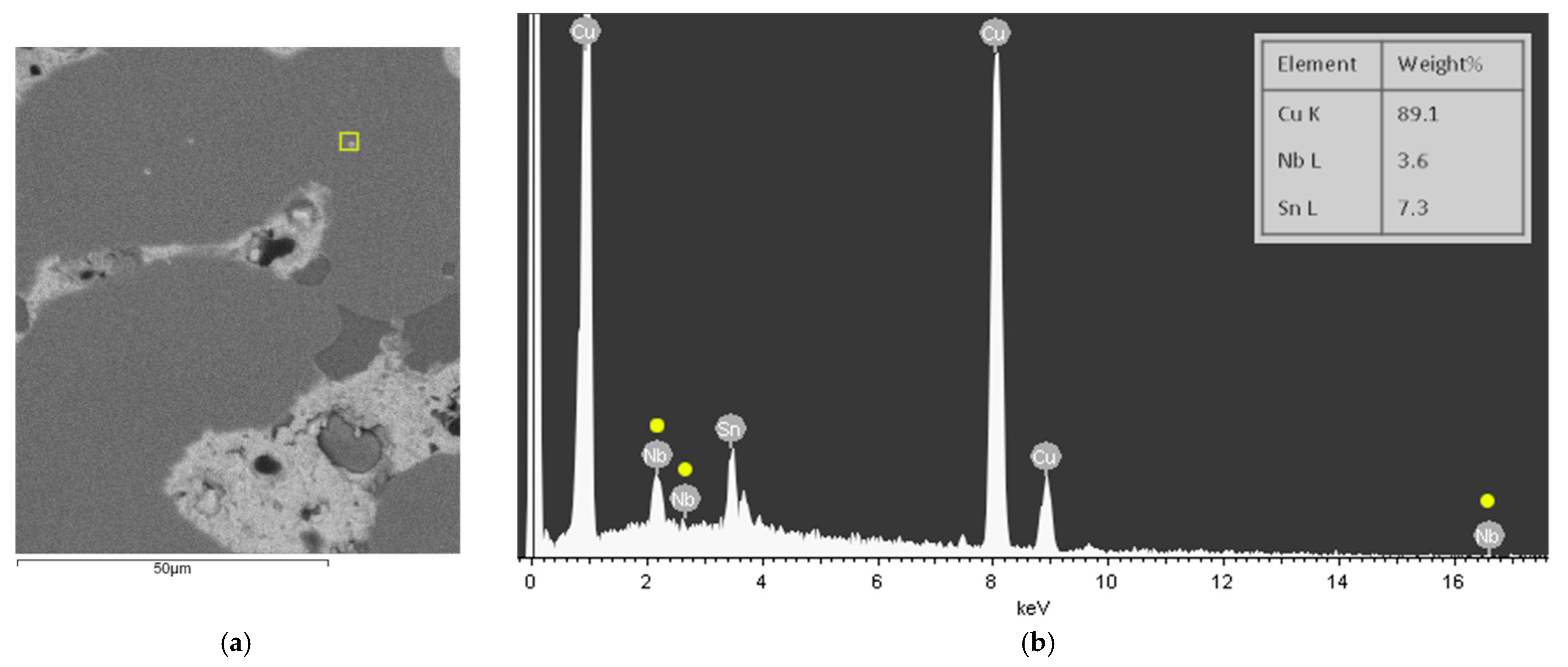
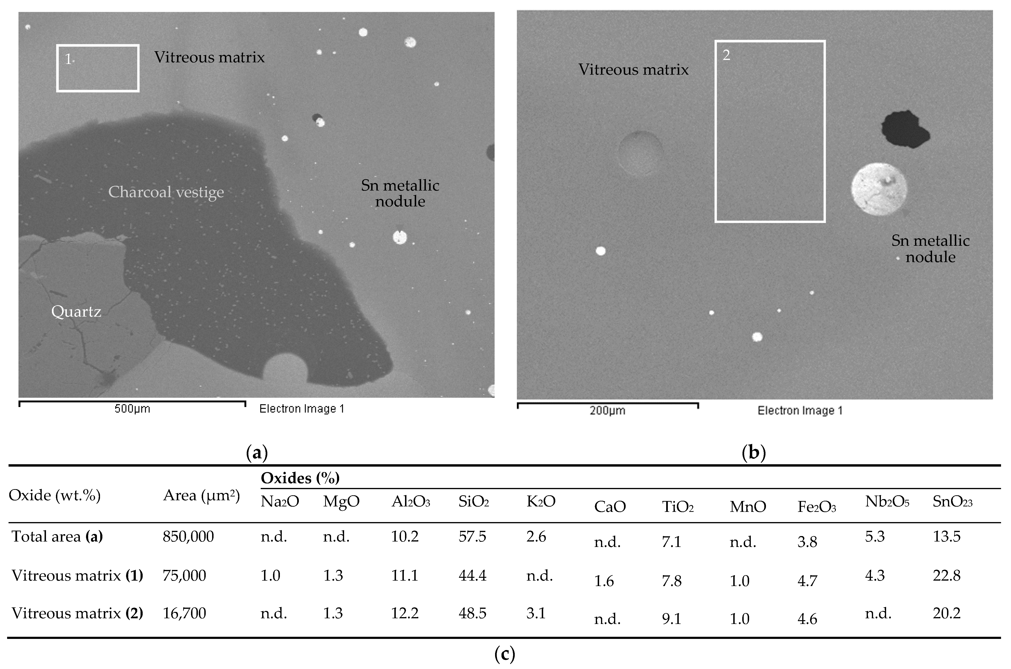
| Debris/Slag | CE 3.319 (C) | +++ | n.d. | n.d. | n.d. | n.d. | - | n.d. | n.d. | Ta, Nb, Ti, W, Zr, Mn | Tin slag | ||
| Ore/mineral | 3.316 (A) | n.d. | +++ | n.d. | n.d. | n.d. | n.d. | - | n.d. | n.d. | Ta?, Nb | Cassiterite (crystal) | |
| Ore/mineral | 3.316 (B) | - | n.d. | n.d. | n.d. | n.d. | +++ | n.d. | n.d. | S++, Ca? | Pyrite (bearing some Cu) | ||
| Item | Inv. Number | Elements (%) | Notes from OM Observations | ||||||||||
|---|---|---|---|---|---|---|---|---|---|---|---|---|---|
| Cu | Sn | Pb | As | Ni | Fe | ||||||||
| Bar frag. | CE00 3363(A) | 87.1 | 11.7 | 1.16 | n.d. | n.d. | 0.05 | Bronze alloy with a microstructure composed by equiaxed alpha-phase grains | |||||
| CE00 3363(B) | 86.0 | 11.3 | 2.31 | 0.09 | 0.14 | 0.08 | Bronze alloy with a microstructure composed by equiaxed alpha-phase grains | ||||||
| CE00 3363(C) | 86.4 | 11.8 | 1.52 | 0.05 | 0.13 | 0.09 | Bronze alloy with a microstructure composed by equiaxed alpha-phase grains | ||||||
| CE00 3363(D) | 90.8 | 6.76 | 2.04 | 0.14 | 0.13 | 0.12 | Bronze alloy with a microstructure composed by equiaxed alpha-phase grains | ||||||
| CE00 3363(E) | 85.1 | 13.4 | 1.33 | 0.03 | n.d. | 0.06 | Bronze alloy with a microstructure composed by equiaxed alpha-phase grains and low amounts of (alpha + delta) eutectoid | ||||||
| Metal debris | CE 3.319 (A) | 89.4 | 7.98 | 2.33 | 0.13 | 0.15 | <0.05 | Bronze alloy with a coarse microstructure composed by alpha phase dendrites and (alpha + delta) eutectoid | |||||
| CE 3.319 (B) | 84.0 | 15.3 | 0.25 | 0.04 | 0.14 | 0.21 | Bronze alloy with a coarse microstructure composed by alpha phase dendrites and (alpha + delta) eutectoid | ||||||
| CE 3.319 (E) | 86.5 | 12.6 | 0.55 | 0.17 | 0.13 | <0.05 | Bronze alloy with a coarse microstructure composed by alpha phase dendrites and (alpha + delta) eutectoid | ||||||
| CE 3.319 (F) | 78.4 | 8.50 | 12.3 | 0.44 | 0.29 | 0.16 | Leaded bronze with a coarse microstructure | ||||||
| CE 3.319 (H) | 95.3 | 4.19 | 0.20 | n.d. | 0.26 | <0.05 | Bronze with a coarse microstructure | ||||||
| Oxides (%) | |||||||||||||
| SiO2 | K2O | TiO2 | MnO | Fe2O3 | Rb2O | SrO | ZrO | Nb2O5 | SnO2 | Ta2O5 | WO3 | ||
| Tin slag | CE 3.319 (C) | (n.q.) | 3.5 | 32.7 | 2.1 | 10.2 | 0.06 | 0.04 | 0.5 | 1.4 | 41.7 | 3.4 | 4.3 |
| Part | Na2O | MgO | Al2O3 | SiO2 | P2O5 | SO3 | K2O | CaO | TiO2 | Cr2O3 | MnO | Fe2O3 | ZnO | Rb2O | SrO | ZrO2 | Nb2O5 | SnO2 | La2O3 | CeO2 | Ta2O5 | WO3 | ThO2 |
|---|---|---|---|---|---|---|---|---|---|---|---|---|---|---|---|---|---|---|---|---|---|---|---|
| (1) | 1.16 | 0.456 | 11.0 | 65.4 | 0.699 | 0.047 | 4.29 | 0.79 | 2.97 | 0.019 | 0.202 | 6.65 | 0.022 | 0.045 | 0.013 | 0.148 | 0.132 | 4.85 | n.d. | 0.066 | 0.143 | 0.83 | 0.009 |
| (2) | 1.36 | 0.441 | 10.3 | 61.0 | 0.813 | 0.047 | 3.98 | 0.97 | 3.97 | n.d. | 0.197 | 8.47 | 0.028 | 0.049 | 0.014 | 0.222 | 0.156 | 6.76 | n.d. | 0.085 | 0.190 | 1.32 | 0.016 |
| (3) | n.d. | 0.430 | 10.0 | 64.1 | 0.535 | 0.049 | 4.02 | 1.97 | 4.97 | n.d. | 0.168 | 8.30 | 0.026 | 0.052 | 0.012 | 0.209 | 0.151 | 6.43 | 0.057 | 0.097 | 0.131 | 0.82 | 0.018 |
Publisher’s Note: MDPI stays neutral with regard to jurisdictional claims in published maps and institutional affiliations. |
© 2022 by the authors. Licensee MDPI, Basel, Switzerland. This article is an open access article distributed under the terms and conditions of the Creative Commons Attribution (CC BY) license (https://creativecommons.org/licenses/by/4.0/).
Share and Cite
Figueiredo, E.; Rodrigues, A.; Fonte, J.; Meunier, E.; Dias, F.; Lima, A.; Gonçalves, J.A.; Gonçalves-Seco, L.; Gonçalves, F.; Pereira, M.F.C.; et al. Tin and Bronze Production at the Outeiro de Baltar Hillfort (NW Iberia). Minerals 2022, 12, 758. https://0-doi-org.brum.beds.ac.uk/10.3390/min12060758
Figueiredo E, Rodrigues A, Fonte J, Meunier E, Dias F, Lima A, Gonçalves JA, Gonçalves-Seco L, Gonçalves F, Pereira MFC, et al. Tin and Bronze Production at the Outeiro de Baltar Hillfort (NW Iberia). Minerals. 2022; 12(6):758. https://0-doi-org.brum.beds.ac.uk/10.3390/min12060758
Chicago/Turabian StyleFigueiredo, Elin, Alexandra Rodrigues, João Fonte, Emmanuelle Meunier, Filipa Dias, Alexandre Lima, José Alberto Gonçalves, Luís Gonçalves-Seco, Filipe Gonçalves, Manuel F. C. Pereira, and et al. 2022. "Tin and Bronze Production at the Outeiro de Baltar Hillfort (NW Iberia)" Minerals 12, no. 6: 758. https://0-doi-org.brum.beds.ac.uk/10.3390/min12060758