
A Chironomid Record of Early-Middle Holocene Environmental Evolution in the Darhad Basin, Northern Mongolia

 , ,
, ,
Abstract
:Simple Summary
Abstract
1. Introduction
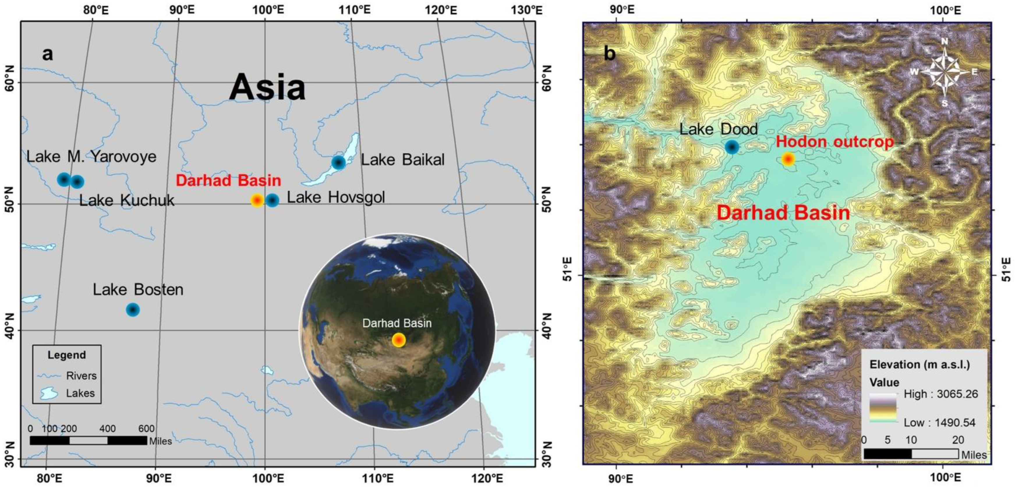
2. Regional Setting
3. Materials and Methods
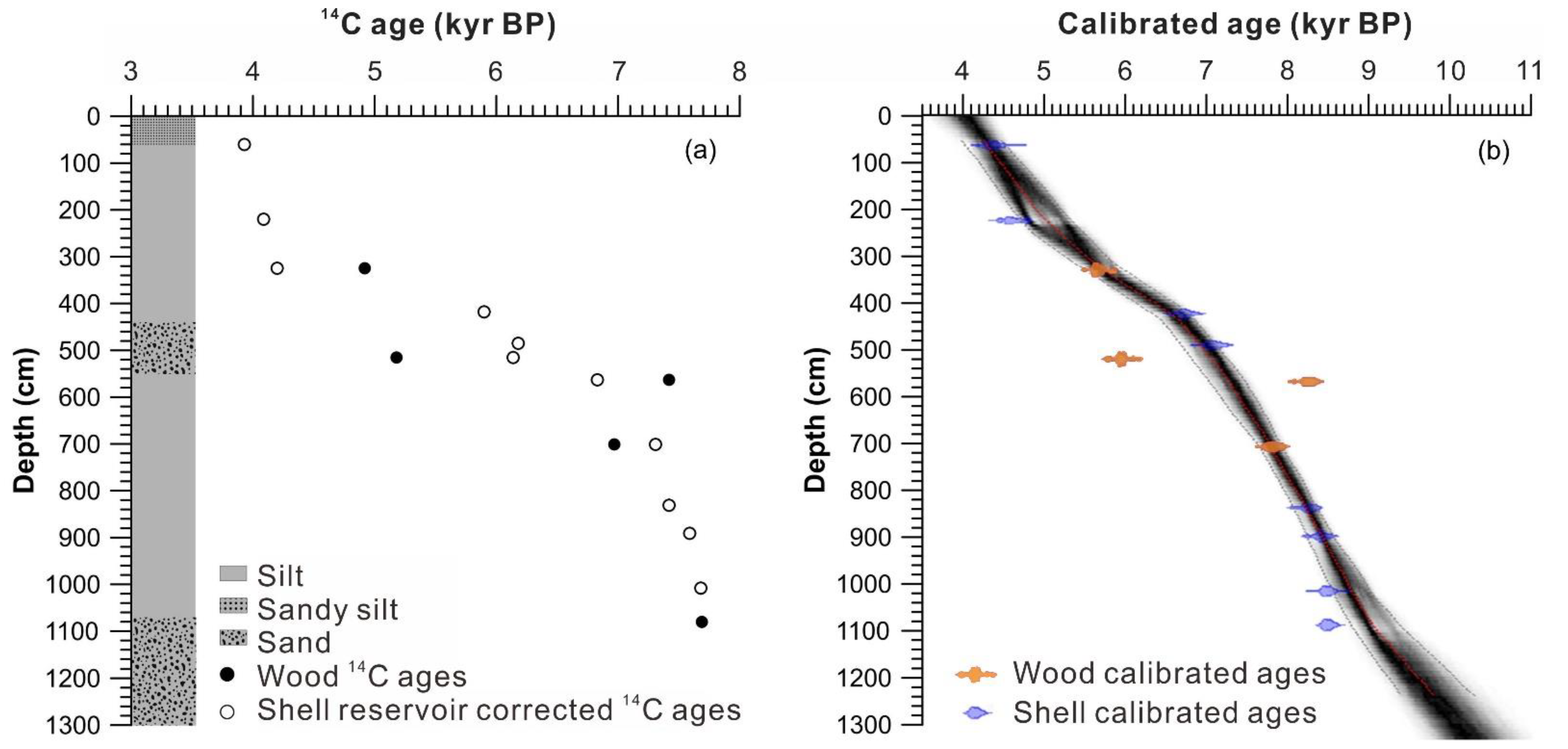
3.1. Coring and Chronology
3.2. Laboratory Analysis
3.3. Numerical Analyses
4. Results
4.1. Core Description and Age Model
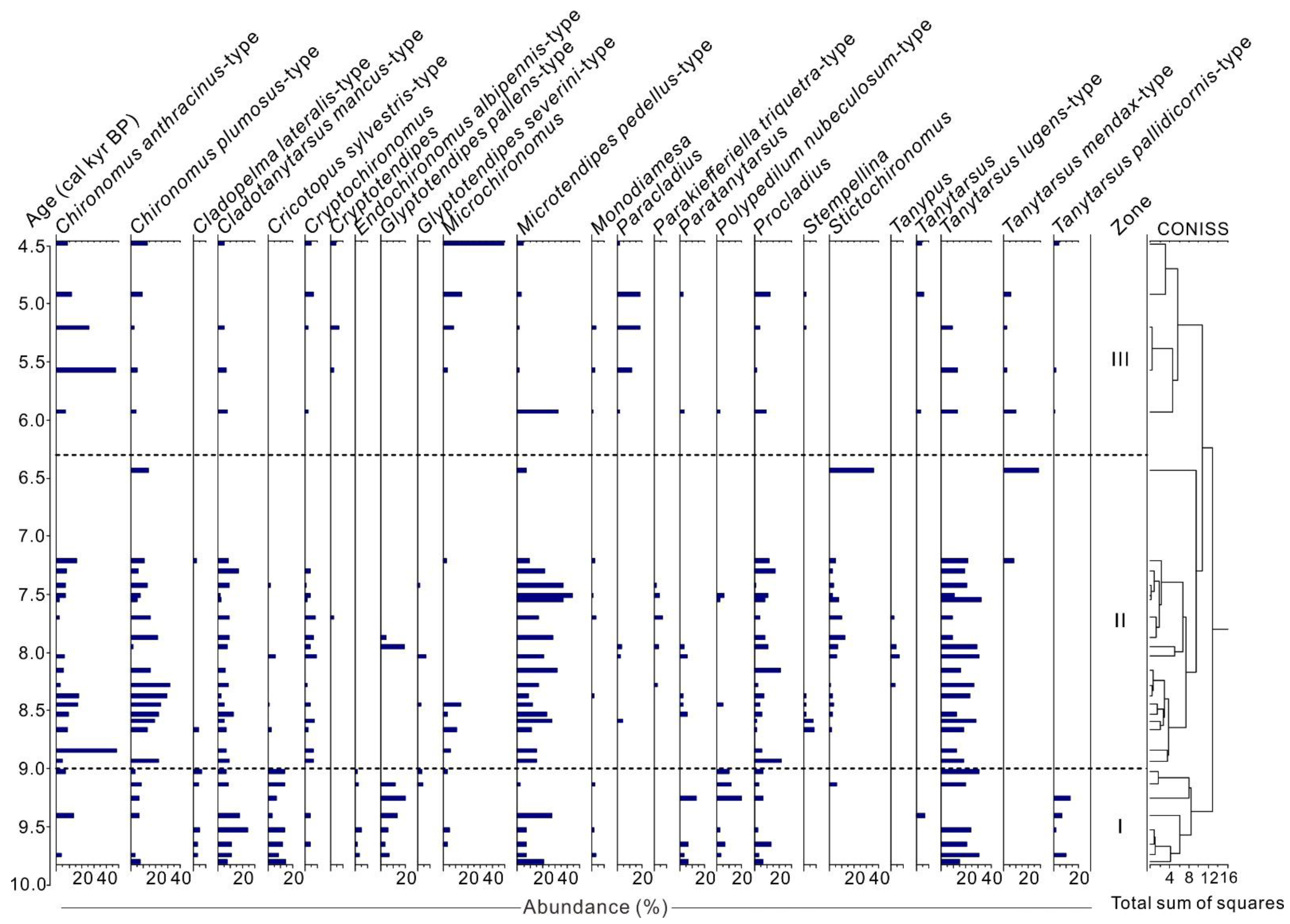
4.2. Chironomid Assemblages
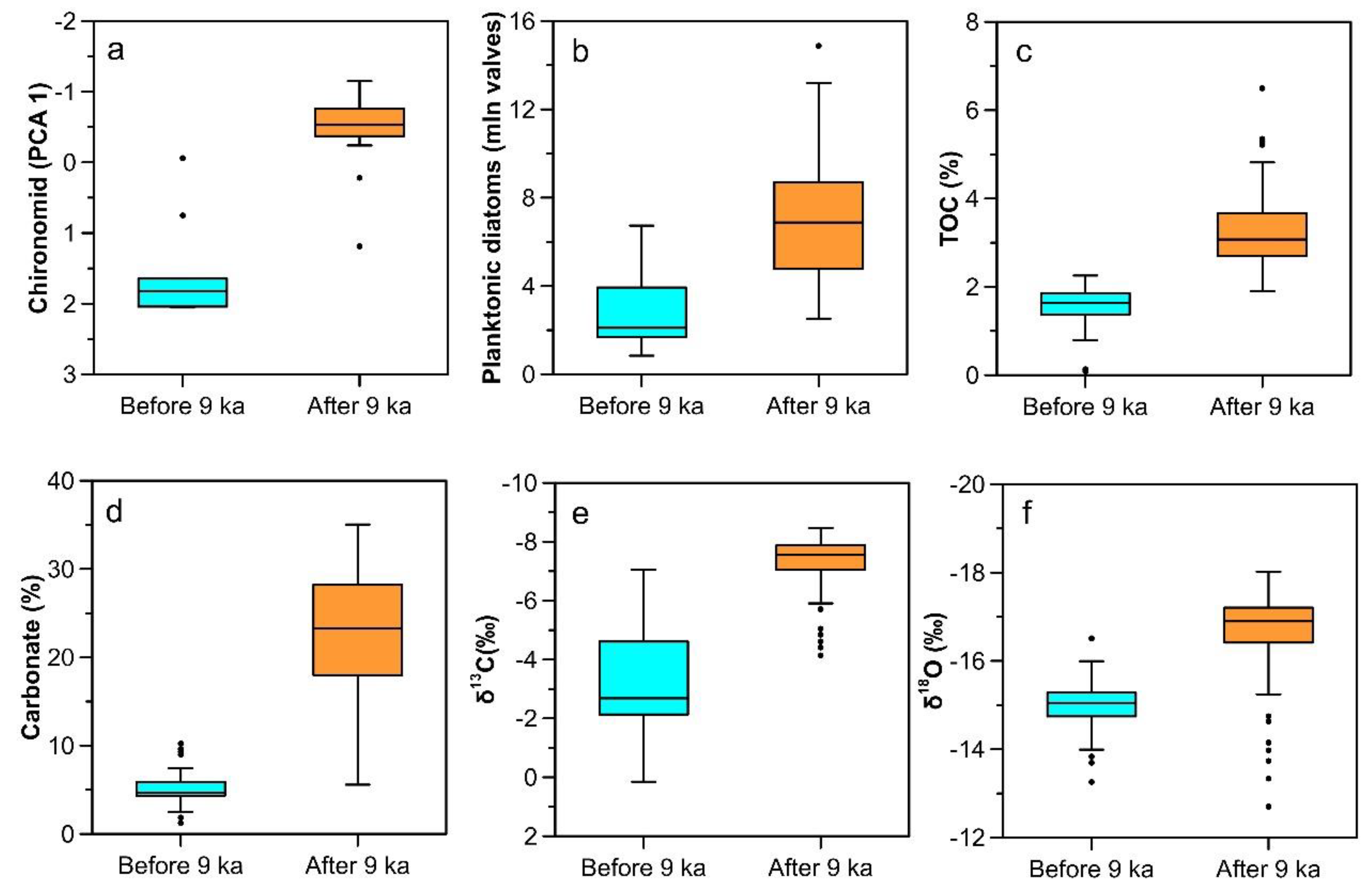
4.3. Ordination Analysis and Regime Shift Detection
5. Discussion
5.1. Chironomid Community Evolution
5.2. The Aquatic Communities as Indicators of Regime Shift in Lake Environment
5.3. Regional Environmental Evolution and Possible Driving Mechanisms

6. Conclusions
Author Contributions
Funding
Institutional Review Board Statement
Informed Consent Statement
Data Availability Statement
Conflicts of Interest
References
- Tao, S.; Fang, J.; Zhao, X.; Zhao, S.; Shen, H.; Hu, H.; Tang, Z.; Wang, Z.; Guo, Q. Rapid loss of lakes on the Mongolian Plateau. Proc. Natl. Acad. Sci. USA 2015, 112, 2281–2286. [Google Scholar] [CrossRef] [PubMed] [Green Version]
- AghaKouchak, A.; Mirchi, A.; Madani, K.; Di Baldassarre, G.; Nazemi, A.; Alborzi, A.; Anjileli, H.; Azarderakhsh, M.; Chiang, F.; Hassanzadeh, E.; et al. Anthropogenic Drought: Definition, Challenges, and Opportunities. Rev. Geophys. 2021, 59, e2019RG000683. [Google Scholar] [CrossRef]
- Kovach, R.P.; Dunham, J.B.; Al-Chokhachy, R.; Snyder, C.D.; Letcher, B.H.; Young, J.A.; Beever, E.A.; Pederson, G.T.; Lynch, A.J.; Hitt, N.P.; et al. An Integrated Framework for Ecological Drought across Riverscapes of North America. BioScience 2019, 69, 418–431. [Google Scholar] [CrossRef] [Green Version]
- Crausbay, S.D.; Ramirez, A.R.; Carter, S.L.; Cross, M.S.; Hall, K.R.; Bathke, D.J.; Betancourt, J.L.; Colt, S.; Cravens, A.E.; Dalton, M.S.; et al. Defining Ecological Drought for the Twenty-First Century. Bull. Am. Meteorol. Soc. 2017, 98, 2543–2550. [Google Scholar] [CrossRef]
- Slette, I.J.; Post, A.K.; Awad, M.; Even, T.; Punzalan, A.; Williams, S.; Smith, M.D.; Knapp, A.K. How ecologists define drought, and why we should do better. Glob. Chang. Biol. 2019, 25, 3193–3200. [Google Scholar] [CrossRef]
- Walker, I.R.; Levesque, A.J.; Cwynar, L.C.; Lotter, A.F. An expanded surface-water palaeotemperature inference model for use with fossil midges from eastern Canada. J. Paleolimnol. 1997, 18, 165–178. [Google Scholar] [CrossRef]
- Zhang, E.; Bedford, A.; Jones, R.; Shen, J.; Wang, S.; Tang, H. A subfossil chironomid-total phosphorus inference model for lakes in the middle and lower reaches of the Yangtze River. Chin. Sci. Bull. 2006, 51, 2125–2132. [Google Scholar] [CrossRef]
- Zhang, E.; Jones, R.; Bedford, A.; Langdon, P.; Tang, H. A chironomid-based salinity inference model from lakes on the Tibetan Plateau. J. Paleolimnol. 2007, 38, 477–491. [Google Scholar] [CrossRef]
- Eggermont, H.; Heiri, O.; Verschuren, D. Fossil Chironomidae (Insecta: Diptera) as quantitative indicators of past salinity in African lakes. Quat. Sci. Rev. 2006, 25, 1966–1994. [Google Scholar] [CrossRef]
- Zhang, E.; Chang, J.; Cao, Y.; Tang, H.; Langdon, P.; Shulmeister, J.; Rong, W.; Yang, X.; Ji, S. A chironomid-based mean July temperature inference model from the south-east margin of the Tibetan Plateau, China. Clim. Past. 2017, 13, 185–199. [Google Scholar] [CrossRef] [Green Version]
- Nazarova, L.; Herzschuh, U.; Wetterich, S.; Kumke, T.; Pestryakova, L. Chironomid-based inference models for estimating mean July air temperature and water depth from lakes in Yakutia, northeastern Russia. J. Paleolimnol. 2011, 45, 57–71. [Google Scholar] [CrossRef]
- Heiri, O.; Brooks, S.J.; Renssen, H.; Bedford, A.; Hazekamp, M.; Ilyashuk, B.; Jeffers, E.S.; Lang, B.; Kirilova, E.; Kuiper, S. Validation of climate model-inferred regional temperature change for late-glacial Europe. Nat. Commun. 2014, 5, 4914. [Google Scholar] [CrossRef] [PubMed]
- Luoto, T.P.; Ojala, A.E.K. Controls of climate, catchment erosion and biological production on long-term community and functional changes of chironomids in High Arctic lakes (Svalbard). Palaeogeogr. Palaeoclimatol. Palaeoecol. 2018, 505, 63–72. [Google Scholar] [CrossRef]
- Schmera, D.; Heino, J.; Podani, J.; Erős, T.; Dolédec, S. Functional diversity: A review of methodology and current knowledge in freshwater macroinvertebrate research. Hydrobiologia 2017, 787, 27–44. [Google Scholar] [CrossRef] [Green Version]
- Pinder, L.C.V. Biology of Freshwater Chironomidae. Annu. Rev. Entomol. 1986, 31, 1–23. [Google Scholar] [CrossRef]
- Ruddiman, W.F. Earth’s Climate, Past and Future, 2nd ed.; Freeman and Company: New York, NY, USA, 2007; pp. 296–298. [Google Scholar]
- Li, G.; Wang, Z.; Zhao, W.; Jin, M.; Wang, X.; Tao, S.; Chen, C.; Cao, X.; Zhang, Y.; Yang, H.; et al. Quantitative precipitation reconstructions from Chagan Nur revealed lag response of East Asian summer monsoon precipitation to summer insolation during the Holocene in arid northern China. Quat. Sci. Rev. 2020, 239, 106365. [Google Scholar] [CrossRef]
- Xiao, J.; Xu, Q.; Nakamura, T.; Yang, X.; Liang, W.; Inouchi, Y. Holocene vegetation variation in the Daihai Lake region of north-central China: A direct indication of the Asian monsoon climatic history. Quat. Sci. Rev. 2004, 23, 1669–1679. [Google Scholar] [CrossRef]
- Wen, R.; Xiao, J.; Fan, J.; Zhang, S.; Yamagata, H. Pollen evidence for a mid-Holocene East Asian summer monsoon maximum in northern China. Quat. Sci. Rev. 2017, 176, 29–35. [Google Scholar] [CrossRef]
- Narantsetseg, T.; Krivonogov, S.K.; Oyunchimeg, T.; Uugantsetseg, B.; Burr, G.S.; Tomurhuu, D.; Dolgorsuren, K. Late Glacial to Middle Holocene climate and environmental changes as recorded in Lake Dood sediments, Darhad Basin, northern Mongolia. Quat. Int. 2013, 311, 12–24. [Google Scholar]
- Prokopenko, A.A.; Khursevich, G.K.; Bezrukova, E.V.; Kuzmin, M.I.; Boes, X.; Williams, D.F.; Fedenya, S.A.; Kulagina, N.V.; Letunova, P.P.; Abzaeva, A.A. Paleoenvironmental proxy records from Lake Hovsgol, Mongolia, and a synthesis of Holocene climate change in the Lake Baikal watershed. Quat. Res. 2007, 68, 2–17. [Google Scholar] [CrossRef]
- Jiang, W.; Leroy, S.A.G.; Yang, S.; Zhang, E.; Wang, L.; Yang, X.; Rioual, P. Synchronous Strengthening of the Indian and East Asian Monsoons in Response to Global Warming Since the Last Deglaciation. Geophys. Res. Lett. 2019, 46, 3944–3952. [Google Scholar] [CrossRef]
- Rudaya, N.; Tarasov, P.; Dorofeyuk, N.; Solovieva, N.; Kalugin, I.; Andreev, A.; Daryin, A.; Diekmann, B.; Riedel, F.; Tserendash, N.; et al. Holocene environments and climate in the Mongolian Altai reconstructed from the Hoton-Nur pollen and diatom records: A step towards better understanding climate dynamics in Central Asia. Quat. Sci. Rev. 2009, 28, 540–554. [Google Scholar] [CrossRef] [Green Version]
- Huang, X.; Peng, W.; Rudaya, N.; Grimm, E.C.; Chen, X.; Cao, X.; Zhang, J.; Pan, X.; Liu, S.; Chen, C.; et al. Holocene Vegetation and Climate Dynamics in the Altai Mountains and Surrounding Areas. Geophys. Res. Lett. 2018, 45, 6628–6636. [Google Scholar] [CrossRef]
- Herzschuh, U. Palaeo-moisture evolution in monsoonal Central Asia during the last 50,000 years. Quat. Sci. Rev. 2006, 25, 163–178. [Google Scholar] [CrossRef] [Green Version]
- Chen, F.; Yu, Z.; Yang, M.; Ito, E.; Wang, S.; Madsen, D.B.; Huang, X.; Zhao, Y.; Sato, T.; John, B.; et al. Holocene moisture evolution in arid central Asia and its out-of-phase relationship with Asian monsoon history. Quat. Sci. Rev. 2008, 27, 351–364. [Google Scholar] [CrossRef]
- Harrison, S.P.; Yu, G.; Tarasov, P.E. Late Quaternary Lake-Level Record from Northern Eurasia. Quat. Res. 1996, 45, 138–159. [Google Scholar] [CrossRef]
- Chen, F.; Chen, J.; Huang, W.; Chen, S.; Huang, X.; Jin, L.; Jia, J.; Zhang, X.; An, C.; Zhang, J.; et al. Westerlies Asia and monsoonal Asia: Spatiotemporal differences in climate change and possible mechanisms on decadal to sub-orbital timescales. Earth Sci. Rev. 2019, 192, 337–354. [Google Scholar] [CrossRef]
- Klinge, M.; Sauer, D. Spatial pattern of Late Glacial and Holocene climatic and environmental development in Western Mongolia—A critical review and synthesis. Quat. Sci. Rev. 2019, 210, 26–50. [Google Scholar] [CrossRef]
- Wang, W.; Feng, Z. Holocene moisture evolution across the Mongolian Plateau and its surrounding areas: A synthesis of climatic records. Earth Sci. Rev. 2013, 122, 38–57. [Google Scholar] [CrossRef]
- Krivonogov, S.K.; Sheinkman, V.S.; Mistruykov, A.A. Stages in the development of the Darhad dammed lake (Northern Mongolia) during the Late Pleistocene and Holocene. Quat. Int. 2005, 136, 83–94. [Google Scholar] [CrossRef]
- Melnikov, P.I.E. Geocryological Conditions of Public Republic Mongolia. In Joint Soviet-Mongolian Research Geological Expedition; Nauka: Moscow, Russia, 1974; Volume 10. [Google Scholar]
- Krivonogov, S.; Yi, S.; Kashiwaya, K.; Kim, J.-Y.; Narantsetseg, T.; Oyunchimeg, T.; Safonova, I.; Kazansky, A.Y.; Sitnikova, T.; Kim, J.-Y.; et al. Solved and unsolved problems of sedimentation, glaciation and paleolakes of the Darhad Basin, Northern Mongolia. Quat. Sci. Rev. 2012, 56, 142–163. [Google Scholar] [CrossRef]
- Batbaatar, J.; Gillespie, A.R. Outburst floods of the Maly Yenisei. Part II—New age constraints from Darhad basin. Int. Geol. Rev. 2016, 58, 1753–1779. [Google Scholar] [CrossRef]
- Belozertseva, I.A.; Kuzmin, V.A. Soils of the Darhad Basin (Northern Mongolia). Geogr. Nat. Resour. 2006, 2, 143–151. [Google Scholar]
- Vyrkin, V.B.; Aleshin, A.G.; Belozertseva, I.A.; Vyrkina, L.A.; Mironova, E.N. Landscapes of the Darhad Basin (Northern Mongolia). Geogr. Nat. Resour. 2004, 2, 140–148. [Google Scholar]
- Reimer, P.J.; Bard, E.; Bayliss, A.; Beck, J.W.; Blackwell, P.G.; Ramsey, C.B.; Buck, C.E.; Cheng, H.; Edwards, R.L.; Friedrich, M. IntCal13 and Marine13 Radiocarbon Age Calibration Curves 0–50,000 Years cal BP. Radiocarbon 2013, 55, 1869–1887. [Google Scholar] [CrossRef] [Green Version]
- Blaauw, M.; Christen, J.A. Flexible Paleoclimate Age-Depth Models Using an Autoregressive Gamma Process. Bayesian Anal. 2011, 6, 457–474. [Google Scholar] [CrossRef]
- Brooks, S.J.; Langdon, P.G.; Heiri, O. The Identification and Use of Palaearctic Chironomidae Larvae in Palaeoecology; Quaternary Research Association: London, UK, 2007. [Google Scholar]
- Quinlan, R.; Smol, J.P. Setting minimum head capsule abundance and taxa deletion criteria in chironomid-based inference models. J. Paleolimnol. 2001, 26, 327–342. [Google Scholar] [CrossRef]
- Wiederholm, T.E. Chironomidae of the Holarctic region: Keys and Diagnoses. Part 1 Larvae; Entomologica Scandinavia Supplement 19; Scandinavian Entomology: Motala, Sweden, 1983. [Google Scholar]
- Heino, J. Patterns of functional biodiversity and function-environment relationships in lake littoral macroinvertebrates. Limnol. Oceanogr. 2008, 53, 1446–1455. [Google Scholar] [CrossRef] [Green Version]
- Cummins, K.W. Trophic Relations of Aquatic Insects. Annu. Rev. Entomol. 1973, 18, 183–206. [Google Scholar] [CrossRef]
- Grimm, E.C. CONISS: A Fortran 77 program for stratigraphically constrained cluster analysis by the method of incremental sum of squares. Comput. Geosci. 1987, 13, 13–35. [Google Scholar] [CrossRef]
- ter Braak, C.J.F.; Smilauer, P. CANOCO Reference Manual and CanoDraw for Windows User’s Guide: Software for Canonical Community Ordination (version 4.5). (Microcomputer Power). Available online: www.canoco.com. (accessed on 10 October 2021).
- Rodionov, S.N. A sequential algorithm for testing climate regime shifts. Geophys. Res. Lett. 2004, 31, L09204. [Google Scholar] [CrossRef] [Green Version]
- Rodionov, S.; Overland, J. Application of a sequential regime shift detection method to the Bering Sea ecosystem. ICES J. Mar. Sci. 2005, 62, 328–332. [Google Scholar] [CrossRef]
- Kovanen, D.J.; Easterbrook, D.J. Paleodeviations of radiocarbon marine reservoir values for the northeast Pacific. Geology 2002, 30, 243–246. [Google Scholar] [CrossRef]
- Berg, M.B. Larval food and feeding behaviour. In The Chironomidae; Armitage, P.D., Cranston, P.S., Pinder, L.C.V., Eds.; Springer: Dordrecht, The Netherlands, 1995; pp. 136–168. [Google Scholar]
- Leite-Rossi, L.A.; Saito, V.S.; Cunha-Santino, M.B.; Trivinho-Strixino, S. How does leaf litter chemistry influence its decomposition and colonization by shredder Chironomidae (Diptera) larvae in a tropical stream? Hydrobiologia 2016, 771, 119–130. [Google Scholar] [CrossRef]
- Grubbs, S.A.; Jacobsen, R.E.; Cummins, K.W. Colonization by Chironomidae (Insecta, Diptera) on three distinct leaf substrates in an Appalachian mountain stream. Ann. Limnol.-Int. J. Limnol. 1995, 31, 105–118. [Google Scholar] [CrossRef] [Green Version]
- García, L.; Pardo, I.; Richardson, J.S. A cross-continental comparison of stream invertebrate community assembly to assess convergence in forested headwater streams. Aquat. Sci. 2014, 76, 29–40. [Google Scholar] [CrossRef]
- Luoto, T.P. Hydrological change in lakes inferred from midge assemblages through use of an intralake calibration set. Ecol. Monogr. 2010, 80, 303–329. [Google Scholar] [CrossRef]
- Ni, Z.; Zhang, E.; Herzschuh, U.; Mischke, S.; Chang, J.; Sun, W.; Ning, D. Taxonomic and functional diversity differentiation of chironomid communities in northern Mongolian Plateau under complex environmental impacts. Hydrobiologia 2020, 847, 2155–2167. [Google Scholar] [CrossRef]
- Nazarova, L.; Self, A.E.; Brooks, S.J.; Hardenbroek, M.V.; Herzschuh, U.; Diekmann, B. Northern Russian chironomid-based modern summer temperature data set and inference models. Glob. Planet. Chang. 2015, 134, 10–25. [Google Scholar] [CrossRef] [Green Version]
- Chen, J.; Zhang, E.; Brooks, S.J.; Huang, X.; Wang, H.; Liu, J.; Chen, F. Relationships between chironomids and water depth in Bosten Lake, Xinjiang, northwest China. J. Paleolimnol. 2014, 51, 313–323. [Google Scholar] [CrossRef]
- Zhang, E.; Zheng, B.; Cao, Y.; Gao, G.; Shen, J. Influence of environmental parameters on the distribution of subfossil chironomids in surface sediments of Bosten lake (Xinjiang, China). J. Limnol. 2012, 71, 291–298. [Google Scholar] [CrossRef] [Green Version]
- Engels, S.; Cwynar, L.C.; Rees, A.B.H.; Shuman, B.N. Chironomid-based water depth reconstructions: An independent evaluation of site-specific and local inference models. J. Paleolimnol. 2012, 48, 693–709. [Google Scholar] [CrossRef]
- Moller Pillot, H.K.M. Chironomidae Larvae of the Netherlands and Adjacent Lowlands: Biology and Ecology of the Chironomini; KNNV Publishing: Zeist, The Netherlands, 2009. [Google Scholar]
- Nazarova, L.; Syrykh, L.S.; Mayfield, R.J.; Frolova, L.A.; Ibragimova, A.G.; Grekov, I.M.; Subetto, D.A. Palaeoecological and palaeoclimatic conditions on the Karelian Isthmus (northwestern Russia) during the Holocene. Quat. Res. 2020, 95, 65–83. [Google Scholar] [CrossRef] [Green Version]
- Nazarova, L.; Bleibtreu, A.; Hoff, U.; Dirksen, V.; Diekmann, B. Changes in temperature and water depth of a small mountain lake during the past 3000 years in Central Kamchatka reflected by a chironomid record. Quat. Int. 2017, 447, 46–58. [Google Scholar] [CrossRef]
- Heiri, O. Within-lake variability of subfossil chironomid assemblages in shallow Norwegian lakes. J. Paleolimnol. 2004, 32, 67–84. [Google Scholar] [CrossRef]
- Raposeiro, P.M.; Saez, A.; Giralt, S.; Costa, A.C.; Gonçalves, V. Causes of spatial distribution of subfossil diatom and chironomid assemblages in surface sediments of a remote deep island lake. Hydrobiologia 2018, 815, 141–163. [Google Scholar] [CrossRef] [Green Version]
- Moos, M.T.; Laird, K.R.; Cumming, B.F. Diatom assemblages and water depth in Lake 239 (Experimental Lakes Area, Ontario): Implications for paleoclimatic studies. J. Paleolimnol. 2005, 34, 217–227. [Google Scholar] [CrossRef]
- Gasse, F.; Lédée, V.; Massault, M.; Fontes, J.-C. Water-level fluctuations of Lake Tanganyika in phase with oceanic changes during the last glaciation and deglaciation. Nature 1989, 342, 57–59. [Google Scholar] [CrossRef]
- Leng, M.J.; Marshall, J.D. Palaeoclimate interpretation of stable isotope data from lake sediment archives. Quat. Sci. Rev. 2004, 23, 811–831. [Google Scholar] [CrossRef] [Green Version]
- Gillespie, A.R.; Burke, R.M.; Komatsu, G.; Bayasgalan, A. Late Pleistocene glaciers in Darhad Basin, northern Mongolia. Quat. Res. 2008, 69, 169–187. [Google Scholar] [CrossRef]
- Komatsu, G.; Arzhannikov, S.G.; Gillespie, A.R.; Burke, R.M.; Miyamoto, H.; Baker, V.R. Quaternary paleolake formation and cataclysmic flooding along the upper Yenisei River. Geomorphology 2009, 104, 143–164. [Google Scholar] [CrossRef]
- Sato, T.; Tsujimura, M.; Yamanaka, T.; Iwasaki, H.; Sugimoto, A.; Sugita, M.; Kimura, F.; Davaa, G.; Oyunbaatar, D. Water sources in semiarid northeast Asia as revealed by field observations and isotope transport model. J. Geophys. Res.-Atmos. 2007, 112, D17112. [Google Scholar] [CrossRef] [Green Version]
- Böhner, J. General climatic controls and topoclimatic variations in Central and High Asia. Boreas 2006, 35, 279–295. [Google Scholar] [CrossRef]
- Rudaya, N.; Krivonogov, S.; Słowiński, M.; Cao, X.; Zhilich, S. Postglacial history of the Steppe Altai: Climate, fire and plant diversity. Quat. Sci. Rev. 2020, 249, 106616. [Google Scholar]
- Marcott, S.A.; Shakun, J.D.; Clark, P.U.; Mix, A.C. A Reconstruction of Regional and Global Temperature for the Past 11,300 Years. Science 2013, 339, 1198–1201. [Google Scholar] [CrossRef] [Green Version]
- Berger, A.; Loutre, M.F. Insolation values for the climate of the last 10 million years. Quat. Sci. Rev. 1991, 10, 297–317. [Google Scholar] [CrossRef]
- Demezhko, D.Y.; Shchapov, V.A. 80,000 years ground surface temperature history inferred from the temperature–depth log measured in the superdeep hole SG-4 (the Urals, Russia). Glob. Planet. Chang. 2001, 29, 219–230. [Google Scholar] [CrossRef]
- Dyke, A.S. An outline of North American deglaciation with emphasis on central and northern Canada. In Developments in Quaternary Sciences; Ehlers, J., Gibbard, P.L., Eds.; Elsevier: Amsterdam, The Netherlands, 2004; Volume 2, pp. 373–424. [Google Scholar]
- Li, T.-Y.; Baker, J.L.; Wang, T.; Zhang, J.; Wu, Y.; Li, H.-C.; Blyakharchuk, T.; Yu, T.-L.; Shen, C.-C.; Cheng, H.; et al. Early Holocene permafrost retreat in West Siberia amplified by reorganization of westerly wind systems. Commun. Earth Environ. 2021, 2, 199. [Google Scholar] [CrossRef]
- Aizen, E.; Aizen, V.; Takeuchi, N.; Mayewski, P.; Grigholm, B.; Joswiak, D.; Nikitin, S.; Fujita, K.; Nakawo, M.; Zapf, A.; et al. Abrupt and moderate climate changes in the mid-latitudes of Asia during the Holocene. J. Glaciol. 2016, 62, 411–439. [Google Scholar] [CrossRef] [Green Version]
- Baker, J.L.; Lachniet, M.S.; Chervyatsova, O.; Asmerom, Y.; Polyak, V.J. Holocene warming in western continental Eurasia driven by glacial retreat and greenhouse forcing. Nat. Geosci. 2017, 10, 430–435. [Google Scholar] [CrossRef]
- Katsuta, N.; Matsumoto, G.I.; Hase, Y.; Tayasu, I.; Haraguchi, T.F.; Tani, E.; Shichi, K.; Murakami, T.; Naito, S.; Nakagawa, M.; et al. Siberian permafrost thawing accelerated at the Bølling/Allerød and Preboreal warm periods during the last deglaciation. Geophys. Res. Lett. 2019, 46, 13961–13971. [Google Scholar] [CrossRef]
- Katsuta, N.; Matsumoto, G.I.; Tani, Y.; Tani, E.; Murakami, T.; Kawakami, S.-I.; Nakamura, T.; Takano, M.; Matsumoto, E.; Abe, O.; et al. A higher moisture level in the early Holocene in northern Mongolia as evidenced from sediment records of Lake Hovsgol and Lake Erhel. Quat. Int. 2017, 455, 70–81. [Google Scholar] [CrossRef]
- Tarasov, P.; Bezrukova, E.; Karabanov, E.; Nakagawa, T.; Wagner, M.; Kulagina, N.; Letunova, P.; Abzaeva, A.; Granoszewski, W.; Riedel, F. Vegetation and climate dynamics during the Holocene and Eemian interglacials derived from Lake Baikal pollen records. Palaeogeogr. Palaeoclimatol. Palaeoecol. 2007, 252, 440–457. [Google Scholar] [CrossRef]
- Ishikawa, M.; Yamkhin, J. Formation Chronology of Arsain Pingo, Darhad Basin, Northern Mongolia. Permafr. Periglac. Process. 2016, 27, 297–306. [Google Scholar] [CrossRef]


| Depth (m) | Lab No. | Material | 14C Age (yr BP) | Reservoir Eliminated Age (yr BP) | Calibrated Age (yr BP) |
|---|---|---|---|---|---|
| 0.6 | ICa100033 | Shell | 6380 ± 50 | 3930 ± 50 | 4380 |
| 2.2 | ICa100034 | Shell | 6540 ± 60 | 4090 ± 60 | 4580 |
| 3.25 | IWd100391 | Wood | 4920 ± 50 | 4920 ± 50 | 5670 |
| 3.25 | ICa100035 | Shell | 6650 ± 50 | 4200 ± 50 | 4710 |
| 4.18 | ICa100036 | Shell | 8350 ± 60 | 5900 ± 60 | 6730 |
| 4.85 | ICa100037 | Shell | 8630 ± 60 | 6180 ± 60 | 7040 |
| 5.15 | IWd100392 | Wood | 5180 ± 50 | 5180 ± 50 | 5940 |
| 5.15 | ICa100038 | Shell | 8590 ± 60 | 6140 ± 60 | 7010 |
| 5.63 | IWd100393 | Wood | 7420 ± 60 | 7420 ± 60 | 8270 |
| 5.63 | ICa100039 | Shell | 9280 ± 60 | 6830 ± 60 | 7690 |
| 7.01 | IWd100394 | Wood | 6970 ± 60 | 6970 ± 60 | 7810 |
| 7.01 | ICa100040 | Shell | 9760 ± 70 | 7310 ± 70 | 8100 |
| 8.31 | ICa100041 | Shell | 9870 ± 70 | 7420 ± 70 | 8210 |
| 8.91 | ICa100042 | Shell | 10040 ± 70 | 7590 ± 70 | 8420 |
| 10.08 | ICa100043 | Shell | 10130 ± 70 | 7680 ± 70 | 8490 |
| 10.8 | IWd100395 | Wood | 7690 ± 60 | 7690 ± 60 | 8490 |
Publisher’s Note: MDPI stays neutral with regard to jurisdictional claims in published maps and institutional affiliations. |
© 2022 by the authors. Licensee MDPI, Basel, Switzerland. This article is an open access article distributed under the terms and conditions of the Creative Commons Attribution (CC BY) license (https://creativecommons.org/licenses/by/4.0/).
Share and Cite
Ni, Z.; Zhang, E.; Yi, S.; Sun, W.; Meng, X.; Ning, D.; Kim, J.C. A Chironomid Record of Early-Middle Holocene Environmental Evolution in the Darhad Basin, Northern Mongolia. Insects 2022, 13, 461. https://0-doi-org.brum.beds.ac.uk/10.3390/insects13050461
Ni Z, Zhang E, Yi S, Sun W, Meng X, Ning D, Kim JC. A Chironomid Record of Early-Middle Holocene Environmental Evolution in the Darhad Basin, Northern Mongolia. Insects. 2022; 13(5):461. https://0-doi-org.brum.beds.ac.uk/10.3390/insects13050461
Chicago/Turabian StyleNi, Zhenyu, Enlou Zhang, Sangheon Yi, Weiwei Sun, Xianqiang Meng, Dongliang Ning, and Jin Cheul Kim. 2022. "A Chironomid Record of Early-Middle Holocene Environmental Evolution in the Darhad Basin, Northern Mongolia" Insects 13, no. 5: 461. https://0-doi-org.brum.beds.ac.uk/10.3390/insects13050461