The Hell Creek Formation, Montana: A Stratigraphic Review and Revision Based on a Sequence Stratigraphic Approach


1
Badlands Dinosaur Museum, Dickinson Museum Center, Dickinson, ND 58601, USA
2
Museum of the Rockies, Montana State University, Bozeman, MT 59717, USA
Geosciences 2020, 10(11), 435; https://0-doi-org.brum.beds.ac.uk/10.3390/geosciences10110435
Submission received: 12 September 2020
/
Revised: 20 October 2020
/
Accepted: 30 October 2020
/
Published: 5 November 2020
(This article belongs to the Special Issue Geological and Biological Records of the End-Cretaceous Terrestrial Successions)
Abstract
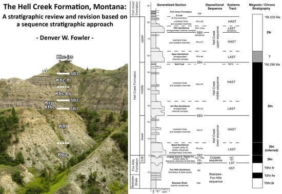
:The Upper Maastrichtian fluvial Hell Creek Formation of the Fort Peck Lake area, Montana (and regional equivalents) is notable for its vertebrate fossils and for the K-Pg mass extinction at or near its upper contact. Despite intense study, internal stratigraphy of the Hell Creek Formation is still poorly constrained, hindering study. This work reviews the stratigraphy of the Hell Creek Formation, as currently understood, and proposes important revisions to the recently proposed type section, particularly concerning complexity of the Hell Creek Formation basal contact. This work also subdivides the Montanan Hell Creek Formation into four 4th order depositional sequences, superimposed over a 3rd order marine transgression. Sequence boundaries are defined by four, laterally continuous disconformities formed by pauses in the creation of accommodation space, marked by overlying amalgamated channel complexes, or less commonly, correlative interfluve paleosols. Cyclicity in Montana may be correlative with similar 4th order cyclicity and marine influence documented in North and South Dakota, Alberta, and Saskatchewan. Magnetostratigraphy and new biostratigraphic data support correlation of the upper Montanan sequence with the North Dakotan Cantapeta tongue (and overlying fines) and Canadian Scollard and Frenchman Formations.
1. Introduction
The Laramide synorogenic fluviatile sediments of the Hell Creek Formation were deposited on a coastal plain bordering the Western Interior Seaway during the Maastrichtian stage of the latest Cretaceous [1]. Surface exposures of the Hell Creek Formation occur in Montana, North Dakota and South Dakota, USA, with regional equivalents occurring in Wyoming and Colorado, USA, and southern Alberta and Saskatchewan, Canada [2]. The Hell Creek Formation is among few geological units worldwide that record terrestrial environments at the close of the Cretaceous. It is famous for the K-Pg mass extinction which occurs at or near the upper formational contact, and for its vertebrate fossils, especially dinosaurs [3,4].
Indeed, it was paleontological interest that first prompted Barnum Brown to investigate the badlands north of the town of Jordan, in what is now Garfield County, Montana, seeking grand exhibits for the halls of the American Museum of Natural History, New York (AMNH). Brown [5] also recorded the first details of the local geology, recognizing the “Hell Creek beds” as a distinct unit, partly based on the absence of significant lignites compared to their abundance in the basal part of the overlying Fort Union Formation (then referred to as the “lignite beds”). Brown also recognized the disconformable nature of the basal contact of the Hell Creek with the underlying Fox Hills Formation [5,6], and was the first to note the prominent Hell Creek Basal Sand, and its variable thickness. Since Brown never formalized the Hell Creek beds as a distinct formation, nor designated a type section, researchers persisted with referring to the Montana exposures as “Lance Formation” for a further 45 years (e.g., [7]). The Hell Creek was not designated a formation in its own right until 1952 in Cobban and Reeside’s [8] grand correlation of Late Cretaceous strata of the Western Interior (although see [9], p. 94, who refer to the “Hell Creek Formation” of South Dakota). However, Cobban and Reeside [8] also did not designate a type section, and despite much recent interest, this problem remained until 2014 when a lectostratotype was described by Hartman et al. [10].
In the history of Hell Creek studies, stratigraphic analysis has often lagged behind other areas of investigation such as paleontology or sedimentology. Exceptions include important research into the uppermost Hell Creek Formation and the contact with the overlying Fort Union Formation [11,12,13,14,15,16,17,18]. Otherwise, problems with lithostratigraphy, discontinuous outcrop, lateral discontinuity of facies, weakly constrained biostratigraphy, lack of radiometric dates (although see [19]), and magnetostratigraphic data of limited use have hindered our ability to study this important interval. For example, without internal marker beds within the Hell Creek Formation, it can be difficult to judge the stratigraphic position of any given layer if the upper and lower formational contacts are not observable locally, as is often the case. As a result, precise stratigraphic placement of fossil specimens has been neglected, limiting our understanding of biotic change within the formation. Only relatively recently is this beginning to be unraveled [20,21,22,23,24,25,26,27].
With renewed interest in the formation and its fauna, the time is ripe for a reanalysis of Hell Creek stratigraphy. In conjunction with the new type section [10], this analysis looks to help structure the next phase of investigation by providing an internal stratigraphic subdivision for the Hell Creek Formation in the area south of Fort Peck Lake. This analysis also presents new informal definitions for lower, middle, and upper depositional sequences of the Hell Creek Formation (previously categorized as the lower, middle, and upper thirds [25,27]). This is of utility in discussion of the formation, and the placement of fossils in section ([24,25,26]. There is also some important reinterpretation of the new type section and some other stratigraphic designations of Hartman et al. [10]; mainly related to the highly variable nature of the basal contact. Finally, some minor corrections are suggested for previous magnetostratigraphic interpretations [28,29].
1.1. Geological Setting
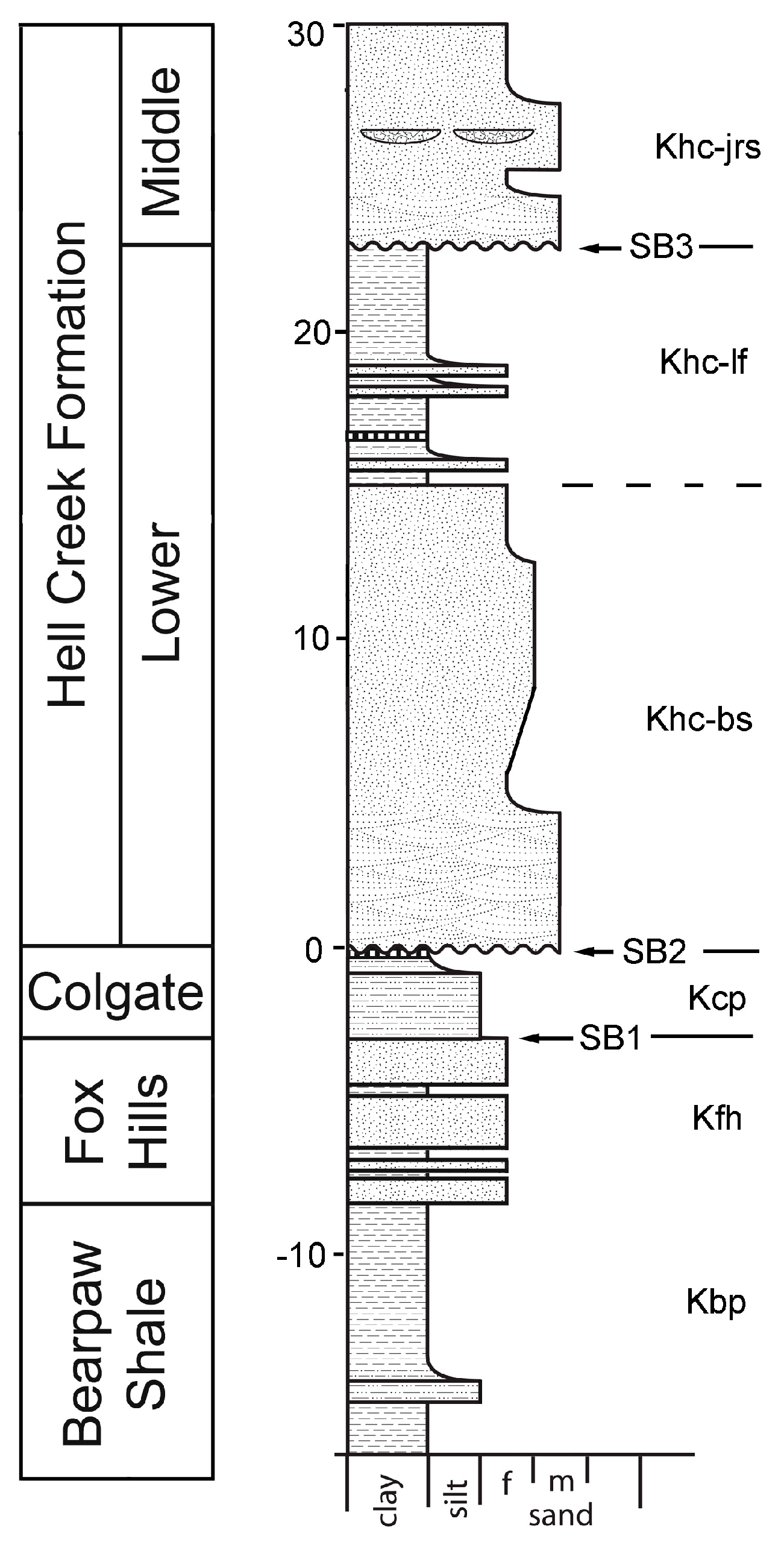
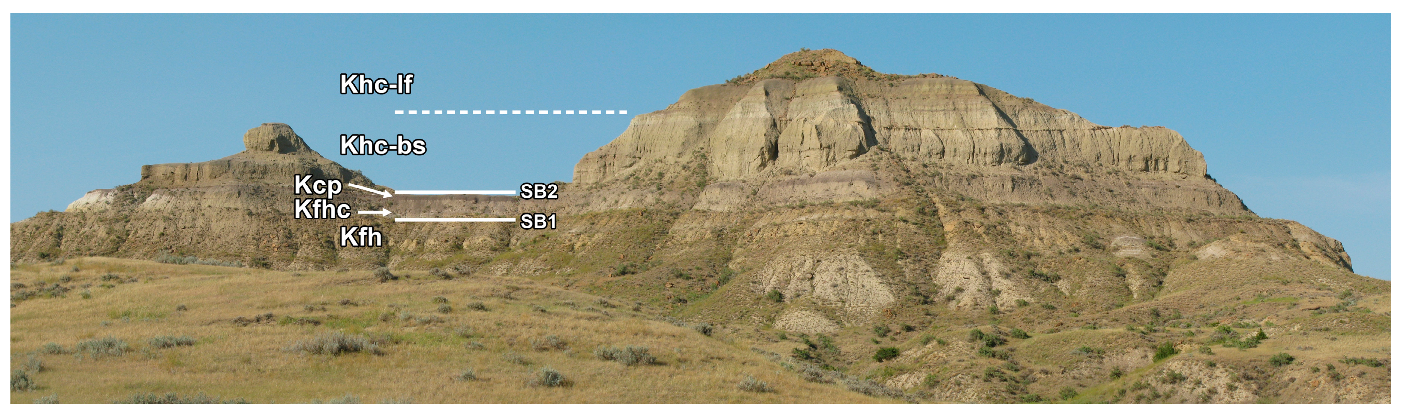
In the area of study around the town of Jordan, Garfield County, Montana, extensive outcrops of the Hell Creek Formation can be observed, including the upper and lower contacts (Figure 1, Figure 2 and Figure 3).
The geological succession begins with the Bearpaw Shale [31] (equivalent to the Pierre Shale of North and South Dakota), a dark grey clay marine shale. In its uppermost parts, the Bearpaw Shale coarsens upwards, and is gradationally supplanted by the Fox Hills Formation.
The Fox Hills Formation [32] is an upward-coarsening sandstone, typically weathering to a conspicuous tan to yellow-orange color, and representing lower through upper shoreface environments deposited as the Fox Hills delta prograded north and west, out into the Bearpaw seaway [20,33,34,35,36]. In Montana, the Fox Hills Formation is undivided other than that in places, the uppermost bed is called the Colgate Member [37] (hereafter referred to as the Colgate Sandstone; [38]), a fine-grained typically pale green-grey sandstone, occasionally outcropping as striking white cliffs when strongly weathered. Somewhat confusingly, it should be noted that the Colgate Sandstone was included within the original definition of the Hell Creek Formation Basal Sandstone by Brown [5]. Historically, the Colgate Sandstone has been variably hypothesized as representing a fluvial, back-barrier beach, lagoonal, tidal, and shallow marine depositional environment [34,39,40,41,42]. More recent work has suggested it represents a broad incised valley fill deposited under initially fluvial, and later estuarine conditions [20,43].
Inclusion of the Colgate Sandstone within the Fox Hills Formation (e.g., [38]) becomes a problem during stratigraphic discussion, as there is no established term with which to refer to the lower, non-Colgate Sandstone part of the Fox Hills Formation (unlike in other states; see [26,34]), and there is evidence that the Colgate Sandstone represents both a different depositional environment and is possibly much younger in age [20,34,43,44]. Collier and Knechtel [44] define a Lower Member of the Fox Hills Formation, but their lithological descriptions of this and the overlying Colgate Member do not match with my personal experience, nor the descriptions of Thom and Dobbin [38], Waage [34], or Flight [20], in that their Colgate Sandstone is described as “light brown”, whereas the defining characteristic of the Colgate Sandstone is that it is conspicuously white, or greyish-white (see references above). In which case, the solution here is simply to treat the Colgate Sandstone as separate from the Fox Hills Formation.
The overlying Hell Creek Formation [8] consists of interbedded sandstones and mudstones [13,45], which are mostly fluvial in origin, with possible marine or tidal influence in basal beds [20,46] and limited horizons throughout the formation in North Dakota [47,48]. The Hell Creek is overlain by fluvial sandstones and mudstones of the Paleogene Fort Union Formation, which exhibits a series of well-developed coal horizons that are especially conspicuous at and immediately above the formational contact [11,12,13,45,49] (Figure 3). Within the lowermost coal (the “z” coal complex), is occasionally preserved a two-layered volcanic ash clay layer enriched in iridium, and containing shocked quartz and spherules [50]. These are considered ejecta from the impact of the meteorite impactor that is hypothesized to have caused the K-Pg boundary mass extinction, and as such this horizon marks the K-Pg boundary [4,50].
Upper Maastrichtian sediments of the Hell Creek Formation were deposited into the Williston and Powder River Basins of the Western Interior (Figure 1). The Powder River Basin is a Laramide basin, created by lithospheric flexure resulting from Laramide orogenic thrusting, and extends from east-central Wyoming to south eastern Montana [51,52,53]. The Williston Basin is an intracratonic basin active since the Cambrian, which extends across southern Alberta, Saskatchewan, Montana, North Dakota, and South Dakota, [51,52,53]. In contrast to the largely interconnected basins of the Sevier orogeny, Laramide uplifts divided depositional basins so that many became isolated (especially intermontane basins) and consequently might have had separate histories of tectonic uplift and subsidence [51]. However, Belt et al. ([54]; page 2) noted that for the Laramide synorogenic sediments of the Northern Rockies at least, the Powder River and Williston Basins might be the only post-Bearpaw Shale examples that “share widely inter-related basinal patterns and also presumably unconformities”. In which case, sediments of the Williston and Powder River Basins represent an ideal starting point from which to construct a regional sequence stratigraphic framework for the latest Cretaceous. As such, the areal extent of the Hell Creek Formation (or equivalents), stretches across Montana, North and South Dakota, Wyoming (Lance Formation), and Saskatchewan (Frenchman Formation), with possible equivalents in Alberta (Scollard Formation) and Colorado (Denver Formation).
Sedimentology of the Montana Hell Creek Formation has been intensively studied. Early work focused on describing broad sedimentological patterns and the nature of formational contacts [5,6,33,37]. Later, pioneering work of the Clemens Lab and others (e.g., [11,39]) critically analyzed sediments throughout the formation and laid the foundation for more detailed sedimentological descriptions and facies analysis [10,13,20,45,46,50,55,56,57,58,59]. The results of these studies have led to Hell Creek Formation paleoenvironments being relatively well understood, although their stratigraphic significance and distribution has attracted less attention.
1.2. Stratigraphy and Age
1.2.1. Biostratigraphy
In 1990, Johnson and Hickey [60] subdivided the Hell Creek Formation of southwest North Dakota into three megafloral zones, later correlating these partially with magnetostratigraphic data [61]. Palynostratigraphic analysis has mostly concentrated on the 20 or so meters either side of the K-Pg boundary (e.g., [62,63]), although some work focused on the entire formation (or equivalent; e.g., [64,65,66,67,68,69]; see [4], for review). Wilson [21] noted variation in mammalian faunal dynamics through the Hell Creek Formation, and related this to environmental changes. Scannella et al. [25] showed that different species of the dinosaur Triceratops occur at different stratigraphic levels of the Hell Creek Formation, partly correlatable to magnetostratigraphy. A similar pattern was noted for pachycephalosaurs [26]. Other biostratigraphic studies [11,12,13,14,15,16] concentrated close to the K-Pg boundary, and as such do not address the formation as a whole.
Perhaps the most prominent biostratigraphic indicator within this sequence is the K-Pg mass extinction, which marks the end of the Cretaceous Period and Mesozoic Era. In Montana the K-Pg boundary is coincident with the upper contact of the Hell Creek Formation with the overlying Fort Union Formation [4]. Below the K-Pg boundary, the fossil fauna is dominated by dinosaurs whose large bones are conspicuous in outcrop; whereas above the K-Pg boundary bones of large animals are absent, and the vertebrate fauna is dominated by small mammals (for a detailed review, see [4]).
1.2.2. Chemostratigraphy
Chemostratigraphic analyses have mostly concerned the uppermost 20 m (e.g., [70]). However, some analyses have addressed the entire formation, documenting a negative carbon isotope excursion at the K-Pg boundary, with six negative carbon isotope excursions, and four tentative positive carbon isotope excursions within the Hell Creek Formation itself [71].
1.2.3. Lithostratigraphy
Subdivision of the Hell Creek Formation into lithostratigraphic members has proven challenging due to lateral discontinuity of distinctive facies. However, Frye [72,73] named a number of members for North Dakota, although these are now considered unrecognizable ([4,47,74]; although see [39]).
Less formal internal divisions of the Montanan Hell Creek Formation have been put forward by other authors [5,10,20,75]. Brown [5] recognized the Basal Sandstone and included within this a unit which would later be considered the Colgate Sandstone by Thom and Dobbin [38]. Flight [20] took a lithostratigraphic approach (similar to Brown [5]), defining the lower Hell Creek Formation as comprising the various mudstones, siltstones and organic rich horizons that typically overlie the Fox Hills Formation (~2 m thick), combined with the overlying Hell Creek Formation Basal Sand (0–12 m thick). Flight’s upper Hell Creek (typically ~75–80 m thick) comprises everything above the upper contact of the Basal Sand to the upper formational contact with the overlying Fort Union Formation. Wilson [75] takes a more utilitarian approach, referring to the lower 47.2 m (155 ft) as “the lower part of the Hell Creek Formation” and the upper 45.7 m (150 ft) as “the upper part of the Hell Creek Formation”.
The most recent attempt to standardize Hell Creek Formation lithostratigraphy was by Hartman et al. [10], who defined a lectostratotype (hereafter referred to as the “type section”) at Flag Butte, near Hell Creek itself. This comprises a ~110 m thick section, of which 84.2 m was determined to represent the full thickness of the Hell Creek Formation. Hartman et al. [10] give informal names for the major sand units which had been used by members of the Hell Creek Project for over a decade (and can be seen in Figure 3); the “Basal Sandstone” is typically present at the base of the Hell Creek Formation [5]. The “Jen Rex Sandstone” occurs ~15 m above the top of the Basal Sandstone. The “Apex Sandstone” and “10 Meter Sandstone” occur ~25–30 m and ~10 m (respectively) below the contact with the Fort Union Formation. However, Hartman et al. [10] probably misinterpret the basal contact of the Hell Creek Formation at the type section, and elsewhere (see Results and Discussion).
A useful lithostratigraphic unit (at least locally) is the Ø or “Null” coal (so named because it occurs below the z coal; see Figure 3); a lignite that occurs within the Hell Creek Formation, ~30 m below the upper contact. The Null coal is well documented in the Bug Creek area [14], but thins to the west (pers. obs.), and is probably absent at the type section. Although relatively laterally restricted, the Null coal is very important as it bears two ashes, dated by Sprain et al. ([19,76] see chronostratigraphy, below).
1.2.4. Well Log Analysis
Connor [77] used spontaneous potential (SP) and resistivity geophysical logs to document regional thickness variation of the Hell Creek and Lance Formations in northeast Wyoming and southeast Montana. The sampled area did not reach as far north as the type area around Jordan, but did include wells ~140 km southwest, near Roundup, and ~80 km south of Glendive in eastern Montana (see Figure 1 for locations). However, Connor [77] could not differentiate the Fox Hills Formation from the Hell Creek/Lance from well log data, nor did he mark any specific horizons or subunits within the Hell Creek or Lance Formations.
1.2.5. Magnetostratigraphy
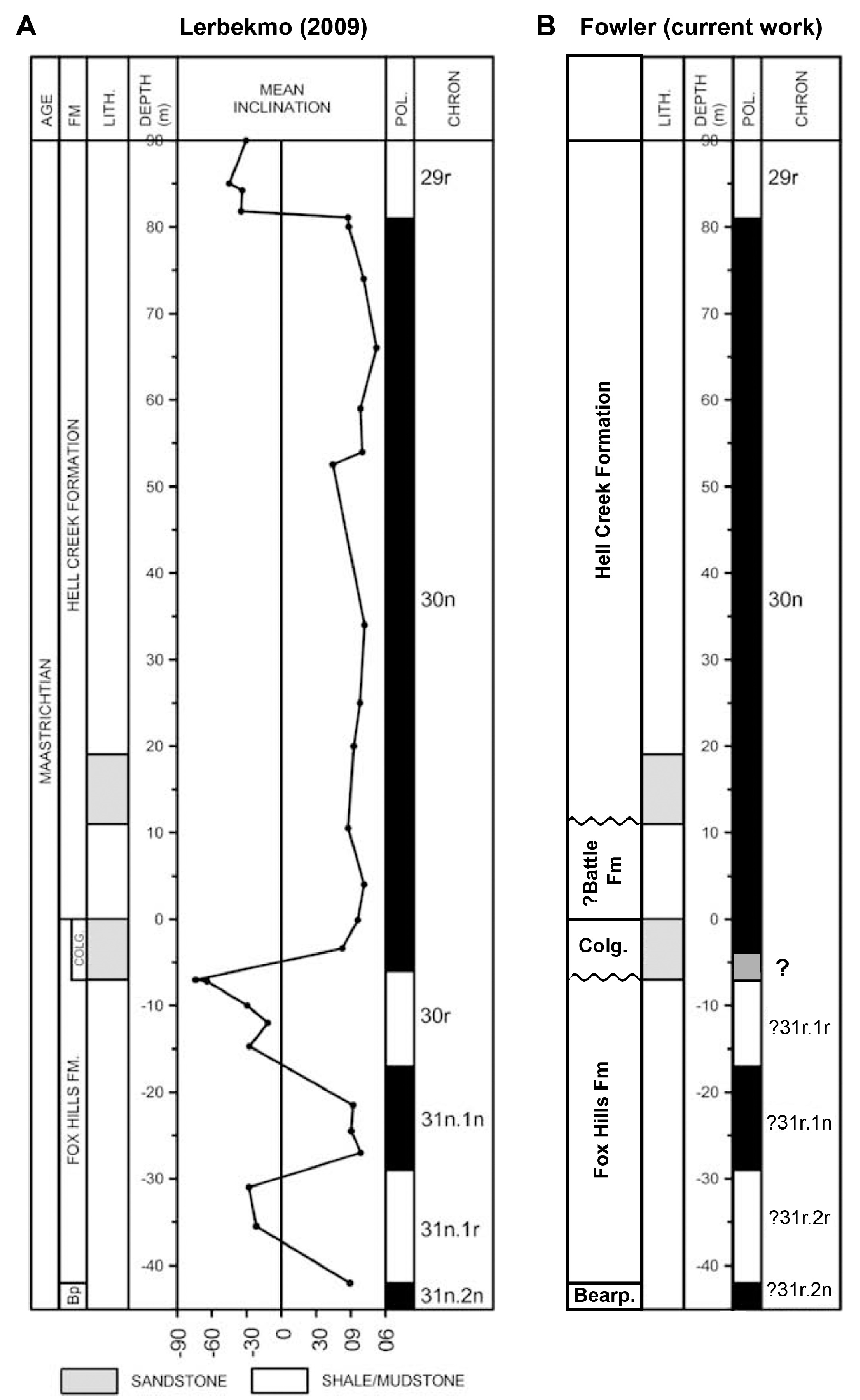
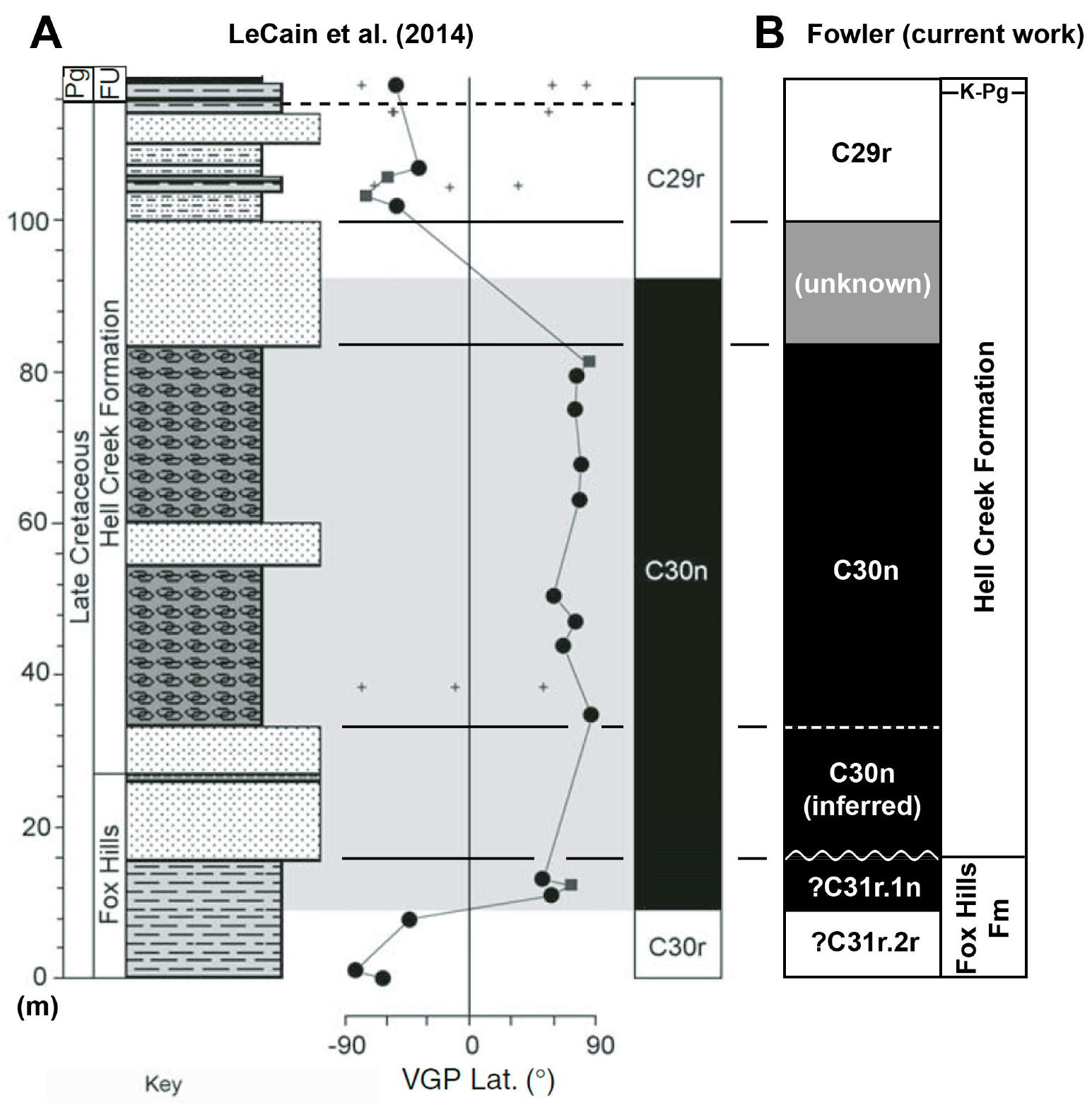
The lowermost two thirds of the Hell Creek Formation is mostly characterized by normal polarity, assigned to C30n (68.196 to 66.398 or 66.304 Ma; [28,29,49,76,78]). However, as sandstone bodies are not typically amenable to paleomagnetic analysis, then the polarity of the Basal Sand has not been determined, although it can be inferred to fall within C30n as the underlying Colgate Sandstone is of normal polarity, and considered to lie within C30n [28].
The uppermost ~30 m of the Hell Creek Formation in the type area is typically of reversed polarity, assigned to C29r [12,28,29,49,76], and corroborated in North Dakota (up to 24 m below the K-Pg boundary [79,80]) and Canadian equivalents [28,81,82]. Position of the C30n-C29r boundary was originally plotted within a thick sandstone (correlating with the Apex Sandstone, but not explicitly identified as such [10,29]). However, this placement was due to methodology dealing with lack of data, rather than the change in signal being recovered from within the sandstone. Placement of the boundary within a sandstone occurred because no signal had been recovered from the sandstone, so the boundary was drawn halfway between the positive signal below, and reversed signal above (following conventional methodology). However, based on new analyses, Sprain et al. (2018) found that the C29r zone extends ~5 m below this sandstone, with the previously detected normal signal of some sections (e.g., [12,29]) being based on uncorrected normal overprinting which was not possible to remove under previous methods.
Within C29r, a short, normal polarity subchron has been detected at the K-Pg boundary, at the top of the Hell Creek equivalent Frenchman Formation (Sakatchewan, Canada [81]; corroborated in time with at least two cores from the Atlantic Ocean [83]). A similarly placed normal subchron was detected 15–20 m below the K-Pg boundary in the Scollard Formation, Red Deer River, Alberta [82]. A normal subchron has not yet been detected within C29r in US sections.
1.2.6. Chronostratigraphy
Constraining an age for the Hell Creek Formation has proven problematic due to sparse chronostratigraphic markers. Despite bentonite clays (derived from volcanic ash; although see [4]) being prevalent throughout the unit, they have not yet yielded any radiometric dates ([47]; K. Johnson, pers. comm., 2009; P. Renne, pers. comm., 2011). Although recent publications (e.g., [4]) have lamented a lack of radiometric dates from within the Hell Creek Formation, in actuality the first radiometric date was published (to surprisingly little fanfare) in 2014 (online first) by Sprain et al. [19] who retrieved an Ar/Ar date of 66.298 ± 0.051 Ma for an ash within the Null coal, ~30 m below the K-Pg boundary (mistakenly shown as ~50 m in [19]; pers. obs.; Sprain pers. comm.; Figure 3). The same analysis sampled a number of horizons within the Z-coal complex (at the K-Pg boundary, technically the basalmost unit of the overlying Fort Union Formation), recovering a range of dates from 66.035–65.962 Ma; note that all the dates in Sprain et al. [19] use the 2011 standard and decay constant pairing of Renne et al. [84], which produces slightly older dates than the more commonly used pairing of Kuiper et al. [85], and Min et al. [86]. The Null coal date [19] is important for two reasons; firstly, it shows that the upper ~30 m of the Hell Creek Formation was deposited in the last 0.263–0.336 Ma of the Cretaceous (which corresponds to the final two depositional cycles identified here; see later). Secondly, although previously thought to occur within magnetozone C30n [19,29], it is now recognized as occurring ~1–2 m above the C30n-C29r boundary ([76]; see above), and has been used in constraining the age of the C30n-C29r boundary.
1.2.7. Age of the Upper and Lower Contacts, and Duration
In Montana, age of the upper formational contact is coincident with the K-Pg boundary (66.0 Ma; [85,87]), and a complex of coals in the overlying Fort Union Formation (66.035–65.962 Ma; [19,76]).
Age determination of the basal contact is more difficult but can be roughly constrained based on magnetostratigraphy. Lerbekmo [28] demonstrated that along the Hell Creek Marina Road (Fish and Wildlife Service Road 105), the Fox Hills Formation is of reversed polarity immediately below the contact with the Colgate Sandstone (similarly observed in the Canadian equivalent Whitemud Formation [88]), and assigns this to C30r (68.369 to 68.196 Ma [78]). This is consistent with biostratigraphic analysis of ammonites from the Fox Hills Formation of North Dakota [89,90]. If this is correct, then the base of the Hell Creek can be no older than ~68.0 Ma. However, there is evidence that the Fox Hills Formation in Montana is older than in North Dakota, suggesting that revision is required (see magnetostratigraphy in Results).
Regardless, if the underlying Colgate Sandstone is indeed C30n [28] then the base of the Hell Creek Formation can be no older than the base of C30n (68.196 Ma [78]). Duration of the Hell Creek Formation can therefore be constrained as no more than ~2 Myr (basal contact no older than ~68.2 Ma, upper contact 66.0 Ma), and likely substantially less. This is consistent with estimates by Wilson [21,22,75] of ~1.8 Myr. Hicks et al. [79] calculated an age estimate of 66.71 to 66.87 Ma (compared to an older date for the K-Pg boundary of 66.5 Ma) for the base of the North Dakota Hell Creek Formation by extrapolating sedimentation rates from the upper part of the succession, giving a total duration of ~1.36 Myr. Lund et al. [80] estimated the duration of the Hell Creek as ~2.5 Myr.
1.2.8. Marine Influence and Sequence Stratigraphic Analysis
With recognition of marine influence in the Hell Creek Formation of North Dakota (Breien Member and Cantapeta Tongue [39,47,72,73,91,92]), supported by floral and faunal data from the whole formation [1,61,93,94,95], it has been realized that unlike in many paleogeographic reconstructions [35], the Western Interior Seaway may not have fully retreated from the Northern US in the latest Maastrichtian [2,96]. Johnson et al. [2] proposed that Hell Creek sediments were not in fact, deposited during the final regression of the Western interior Seaway (as had been the prevailing view; e.g., [3,35]). Rather, the Hell Creek and overlying Fort Union Formations were deposited under transgressive conditions during early inception of the Cannonball Seaway [2]. This non-traditional interpretation is consistent with sequence stratigraphic depositional models, since transgression (through base-level rise) is a stratigraphic control that can create the necessary accommodation required for sediment deposition and preservation. Indeed, there has never been any strong evidence supporting the view that the seaway fully retreated (see the excellent review in Boyd and Lillegraven [96]).
Traditional lithostratigraphy correlates packages of similar lithologies into formations, or members. However, fluvial facies are generally laterally consistent only over a few kilometers at best, making correlation difficult. In contrast, sequence stratigraphy correlates cycles of sedimentation, utilizing key surfaces and stratal stacking patterns. Thus, application of sequence stratigraphic methodology has the potential to subdivide and correlate within the Hell Creek Formation beyond the limitations of lithostratigraphy. Following Johnson et al. [2], Flight [20] provided the first sequence stratigraphic interpretation of the Bearpaw Shale through to the lower third of the Hell Creek Formation in the area south of Ft. Peck Reservoir, Montana. Behringer [43] added further detail to Flight’s [20] interpretation of the Colgate Sandstone as an incised valley with estuarine deposits.
Following Flight [20], this work establishes a sequence stratigraphic framework for the complete Hell Creek Formation in the Fort Peck area. This necessary first step can then be tested further afield in order to construct a regional sequence stratigraphic interpretation for the latest Cretaceous. This paper also includes regional correlates in the analysis that greatly enhance the ability to interpret sequence boundaries observed in outcrop.
2. Methods
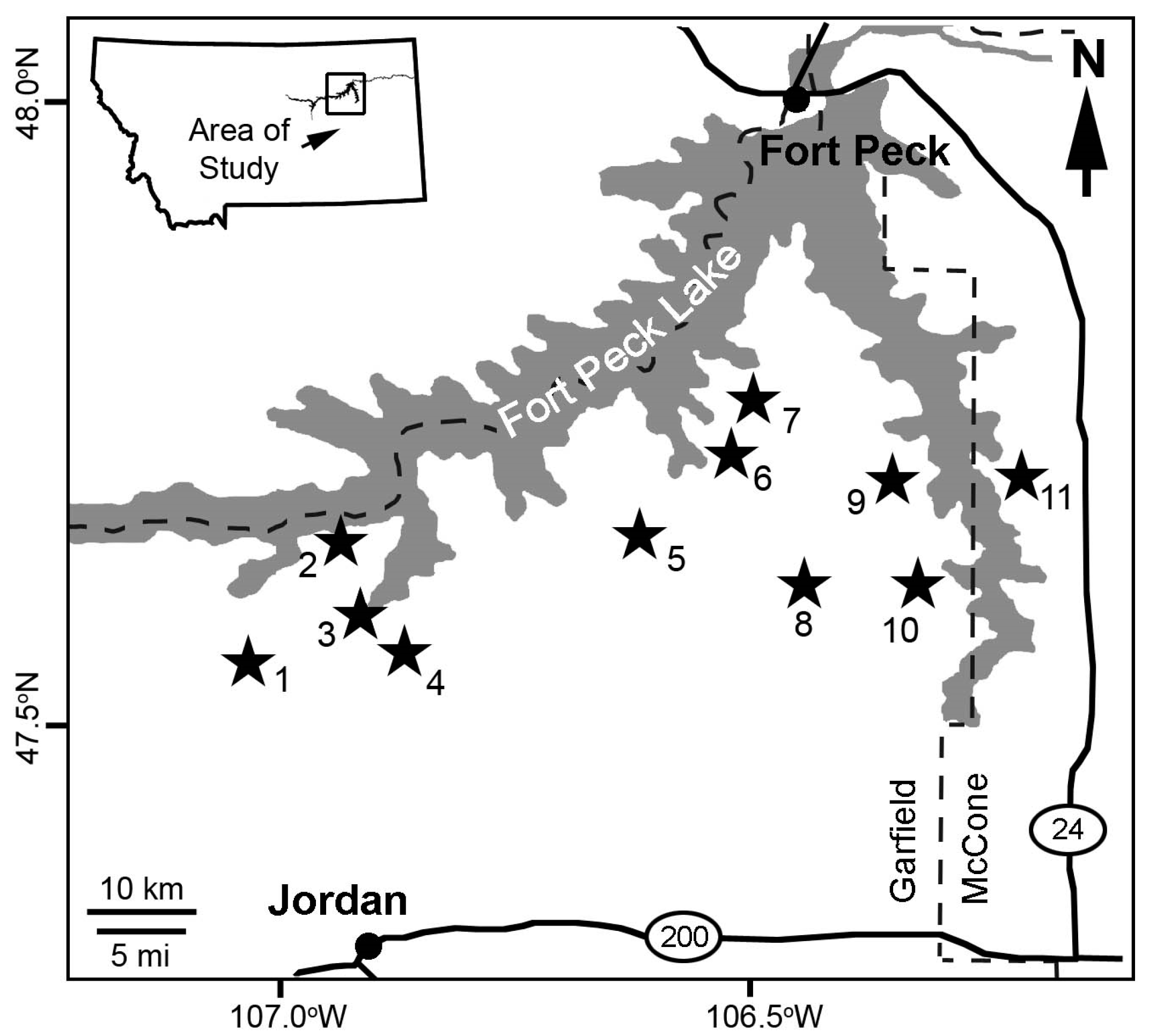
This study is based on field observations and 27 sections measured from 2007–2011. Most sections are from immediately south of Ft. Peck Reservoir, north of Jordan, eastern Montana (Figure 1 and Figure 2). Additional sections are from Ekalaka, southeast Montana, and field observations from Makoshika State Park, Glendive, eastern Montana.
2.1. Stratigraphic Abbreviations
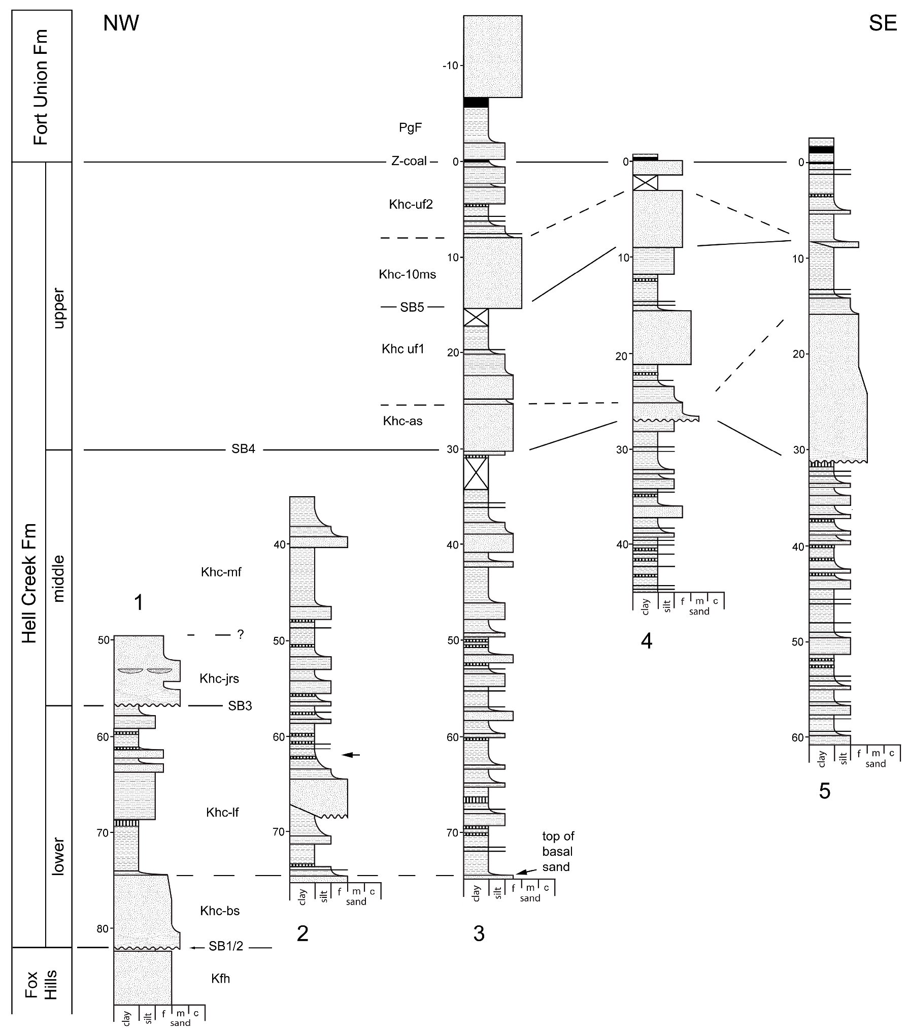
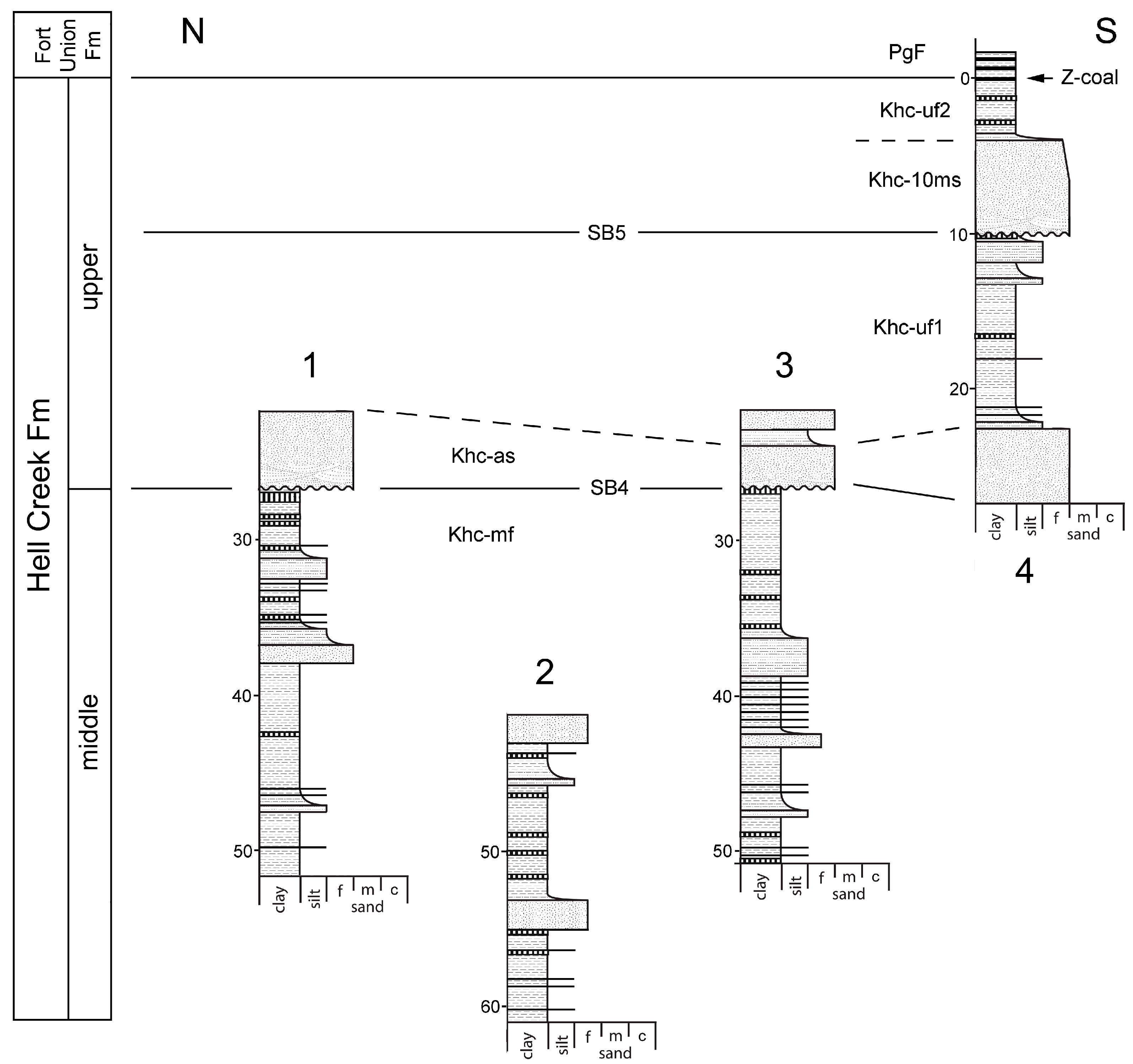
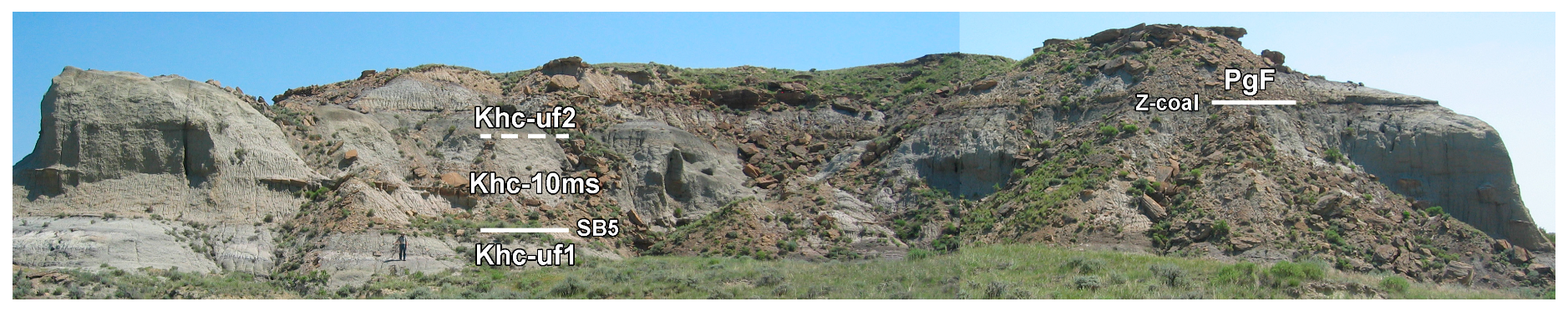
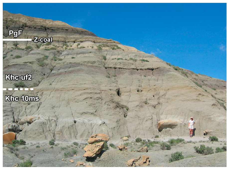
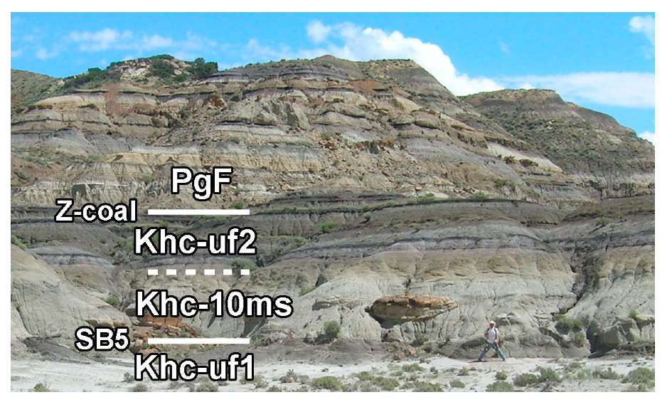
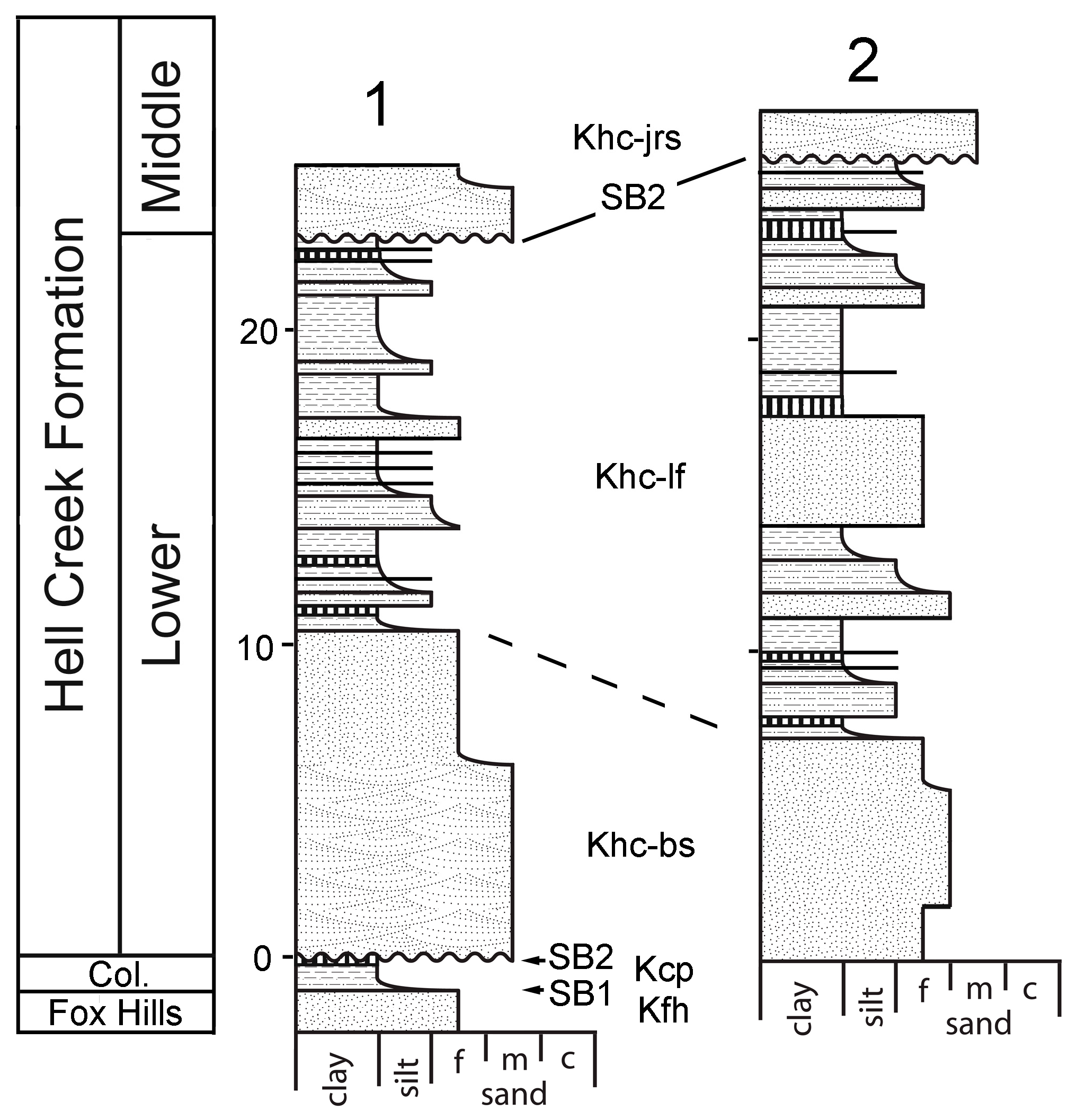
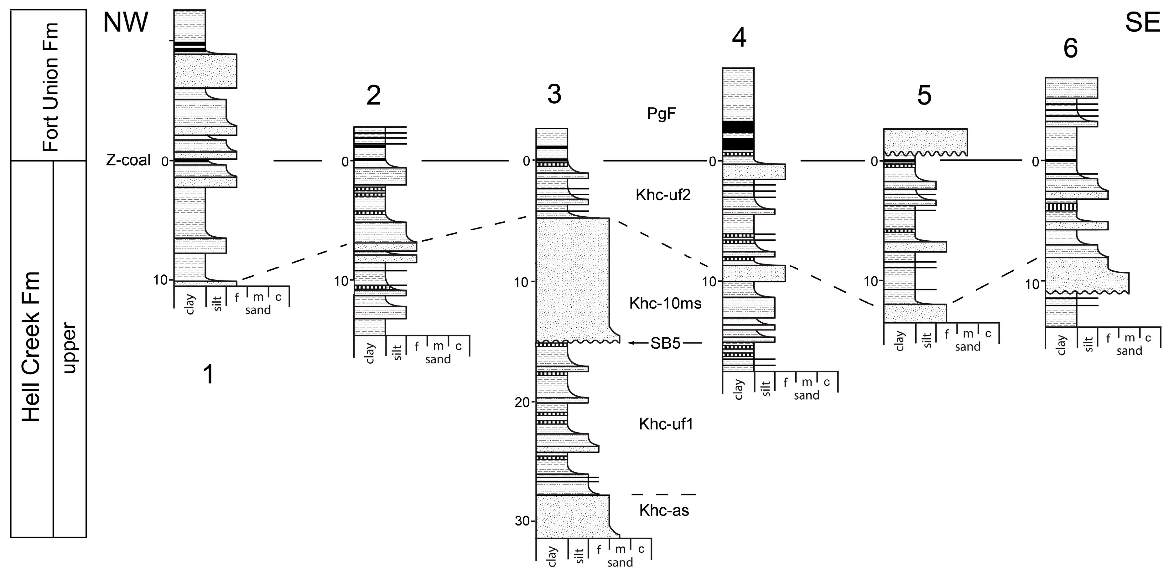
In stratigraphic order, oldest first (Figure 3); see results for definitions and descriptions. Kbp, Bearpaw Shale; Kfh, Fox Hills Sandstone; Kfhc, Colgate Sandstone; Kcp, Colgate tidal flats; Kba, possible Battle Formation; Khc-bs, Hell Creek Formation Basal Sand; Khc-lf, Hell Creek Formation lower fines; Khc-jrs, Hell Creek Formation Jen Rex Sandstone; Khc-mf, Hell Creek Formation middle fines; Khc-as, Hell Creek Formation Apex Sandstone; Khc-uf1, Hell Creek Formation upper fines unit 1; Khc-10ms, Hell Creek Formation 10 Meter Sandstone, Khc-uf2, Hell Creek Formation upper fines unit 2; PgF, Fort Union Formation.
2.2. Orders of Cyclicity
Depositional cycles occur at different orders of magnitude based on their wavelength (duration). This work considers a 1st order cycle is 200–400 Myr; 2nd order cycle, 10–100 Myr; 3rd to 5th order cycles are 0.01–10 Myr; and 4th to 5th order cycles are 0.01–2 Myr (following Mall, [97], including overlaps). Miall [97] cautions that such terminology is no longer recommended; however, it is used here as it is convenient and prevalent in the literature.
2.3. Terrestrial Sequence Stratigraphy
Like its marine counterpart, terrestrial sequence stratigraphy arranges strata into depositional sequences which reflect sedimentological responses to cycles of accommodation and sediment supply [98,99]. A summary of terrestrial sequence stratigraphic methodology and examples from the North American Western Interior is provided in Supplementary Materials.
The Hell Creek Formation presents a slightly unusual case for terrestrial sequence stratigraphy. Firstly, in eastern Montana, the underlying Bearpaw Shale, Fox Hills Sandstone, Colgate Sandstone, and part of the Hell Creek Formation Basal Sand are either marine in origin or exhibit marine influence. Secondly, Hell Creek Formation sediments can be linked to marine transgression in North Dakota [2,47,48]. Hence it is possible to employ marine sequence stratigraphic terminology in at least the lower parts of the succession. Thus, this analysis uses traditional nomenclature for the marine influenced units (Lowstand, Transgressive, and Highstand Systems Tracts; LST, TST, HST, respectively), and terrestrial nomenclature for units that cannot as yet be linked to marine units (High- and Low-Accommodation Systems Tracts, HAST and LAST, respectively; [98,99,100,101,102,103,104,105,106].
3. Results
3.1. Lithofacies and Generalized Section
The following descriptions of individual units are based on the measured sections described later (use Figure 3 as a guide). Lithofacies descriptions (also see Supplementary Materials) mostly follow those of Flight [20], and are comparable to those of Fastovsky [45]. With a few exceptions, most of the described features can be seen at the new type section [10].
3.1.1. Bearpaw Shale (Kbp)
The Bearpaw Shale (Figure 3 and Figure 4) is the basalmost formation considered; as such only the uppermost 10–20 m have been observed. The Bearpaw Shale consists of a generally coarsening upwards sequence, predominantly shale (massive to laminated mudstone, Mml) with occasional interbedded silty sandstone (horizontally stratified silty sandstone, Sh; massive silty sandstone, Sm). Shales are typically mid-dark grey, fissile, massive to laminated, weather to dark grey with occasional iron staining, and form low rounded hills. Beds of pale grey to tan, fine grained silty sandstone, up to 1 m thick, become increasingly common in the upper 5–10 m, where they are interbedded with shale. Silty sandstones are massive, planar bedded or hummocky-cross-stratified, weather to pale grey, form steeper slopes than the underlying shale, and eventually grade into the overlying Fox Hills Sandstone.
3.1.2. Fox Hills Sandstone (Kfh)
The Fox Hills Sandstone is a complex unit that coarsens upwards and exhibits a sheet-like geometry with considerable variation in thickness. Lithologies are typically fine-grained sandstones (hummocky cross-stratified, Shcs; trough cross-bedded, St; ripple cross laminated, Sr; low angle planar bedded, Sl; and massively bedded, Sm) with less common interbedded mudstone (Mm). Grain size is lower to upper fine [33]. It is conspicuous in outcrop by its yellow-orange color (Figure 4, Figure 5 and Figure 6); distinct from the pale grey sandstones of the underlying Bearpaw Shale, or overlying Colgate Sandstone and Hell Creek Formation (although the latter are often tan). The gradational transition from the Bearpaw Shale to Fox Hills Sandstone has led to variable definitions of the position of the contact (e.g., [89,107]). For consistency, here the basalmost bed of the Fox Hills Sandstone follows Flight [20] as either the first amalgamated hummocky cross-stratified sandstone (contrasting the isolated sands of the Bearpaw Shale), first massive sandstone, or first trough cross-stratified sandstone. Typically the Fox Hills Sandstone is 4–6 m thick, but can reach up to 15 m locally [20]. Massive bedding and hummocky cross stratification is more common near the base, with trough cross bedding and ripple cross lamination more common higher in the formation. Thalassinoides and Planolites burrows are recorded in trough cross-stratified sands [20]. Large carbonate-concretions are common throughout [33], but especially in the upper part, which is typically capped by prominent bench-forming cemented sandstones.
3.1.3. Colgate Sandstone (Kfhc)
The Colgate Sandstone is most easily distinguished from the underlying Fox Hills Sandstone by its grey to white weathering color, and greenish-grey fresh surfaces (Figure 7; [37,38,47], although see below). Where present, the Colgate Sandstone rests on an erosive scour (Se) that is typically 0–2 m, but sometimes incises up to 25 m reaching into the Bearpaw Shale [20,43]. Although rarely encountered, a coarse-grained basal lag was recorded by Wheeler [20,40,43]. Otherwise, the Colgate Sandstone is a micaceous, clay-rich fine-grained sandstone, with occasional thin interbedded mudstones (Mm), and rarer laterally restricted coal beds (C2; Figure 8). Bedding is typically planar (Sh) or massive (Sm), although trough cross stratification (St) is visible in particularly thick sections. Total thickness is typically 2–5 m, but up to 15 m in geographically restricted areas (see below; [20]). The Colgate Sandstone is not typically laterally extensive and exhibits mostly restricted channelized geometry [20,43]. Although the degree of cementation may vary, concretions are notably absent, unlike the underlying Fox Hills Sandstone and overlying Basal Sand of the Hell Creek Formation (which may aid in distinguishing the Colgate Sandstone from these units; although note that Waage [34] suggests calcareous concretions are present in Colgate Sandstone exposures of South Dakota, none were observed by myself in Montana). Skolithos burrows are recorded in massive and planar-bedded sandstones [20].
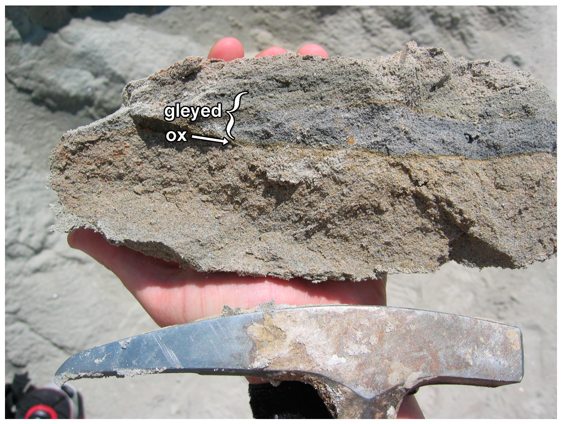
Although the bold white weathered color is considered characteristic of the Colgate Sandstone [20,34,37,38,43,47], this is variable geographically, and not commonly seen in the Hell Creek type area [33], although it is conspicuous at the northern edge of “Best Butte” (see study localities, below). The Colgate Sandstone more typically exhibits dual color banding (Figure 5, Figure 7 and Figure 8), with a lower pale tan unit, and a less colorful but brighter pale grey upper unit. The upper unit exhibits more thin interbedded mudstones than the lower unit, and it is the upper unit that sometimes weathers to a bold white color (Figure 7). In a fresh surface, the contact between the two beds is marked by a thin (~1–2 mm) iron-rich horizon, while the initial 2–3 cm above the contact are notably gleyed (Figure 9). The Colgate Sandstone fines rapidly in the upper 1–2 m into a grey siltstone (Fsm) which is almost always overlain by an organic-rich horizon (C1). These two lithofacies are included here within the Colgate Sandstone, mainly due to the transitional contact of Sm with Fsm making separation difficult, although previous authors (e.g., [20,43,108]) have included these units as the basalmost facies of the Hell Creek Formation. However, to be consistent with original descriptions, and to aid in sequence stratigraphic interpretation, the term Colgate Sandstone is used here to refer only to the sandy part of the unit. The overlying silt and organic-rich horizon are referred to as the Colgate Tidal Flats (Kcp; see below).
3.1.4. Colgate Tidal Flats (Kcp)
This unit has previously been assigned to the lowermost Hell Creek Formation [20,47,109]; however, this is problematic as it is part of the underlying Colgate depositional sequence (see discussion), so it is treated separately here. The Colgate tidal flats are a thin unit with a sheet-like geometry that is more commonly present in outcrop than the Colgate Sandstone itself. It either overlies the Colgate Sandstone (Figure 4 and Figure 5) or lies directly on the Fox Hills Sandstone (Figure 10), and consists of two beds: a lower pale grey muddy siltstone typically ~0.5–1 m thick (although sometimes up to 2 m) that is capped by a prominent organic rich siltstone to sandy siltstone ~1 to 50 cm in thickness (Figure 4, Figure 5 and Figure 10). Depositional environment has been interpreted as a paleosol [109], or as tidal flats [20] deposited during the HST of the Colgate depositional sequence. This unit is overlain by the Basal Sand (or equivalent) of the Hell Creek Formation, or very rarely by a series of lithofacies here tentatively assigned to the Battle Formation.
3.1.5. Battle Formation (Kba)
Between the underlying Colgate Sandstone, and erosively overlying Basal Sand of the Hell Creek Formation, there occasionally occurs an unusual set of lithofacies up to 10 m thick (Figure 5), comprising a basal pale-colored siltstone (seatearth, Fr), an organic rich silt or sandstone (C), and mauve or green-grey banded mudstone (Fml). These lithofacies were assigned (in part) to Fml of the lower Hell Creek Formation by Flight [20]. However, here they are tentatively referred to the Battle Formation (otherwise only recorded in southern Alberta and Saskatchewan), based on similarity to the lithological description by Irish [110], and the occurrence of palynomorphs correlated with the Battle Formation in Alberta and Saskatchewan [28].
These facies show similarity to the organic rich C1 facies defined above as the uppermost facies of the underlying Colgate Sandstone. However, I chose to include C1 within the Colgate Sandstone (rather than the Battle Formation) as C1 is encountered overlying Fsm of the Colgate Formation in sections where neither the sandstone facies of the Colgate Sandstone, nor the Battle Formation facies are present. In the future it might be desirable to remove both Fsm and C1 from the Colgate Sandstone and place them within the Battle Formation, although definition of the boundary between these units in Canada is unclear; for example, it is not clear if the basal bed of the Battle Formation is one of the organic-rich horizons, or the underlying pale siltstone [110,111].
It is necessary to separate these possible Battle Formation facies due to the confusion that their inclusion in either the Colgate or Hell Creek formations might cause concerning the age of these units and their contacts. It is also desirable that the basal unit of the Hell Creek Formation should be maintained as the Basal Sandstone as originally defined by Brown [5], and consistent with current understanding of depositional cyclicity.
These possible Battle Formation facies have only been encountered in the area around Hell Creek itself, most easily observable at Manaige Spring (Figure 5), but also in the cliffs visible on both sides of the usually flooded tributary of Hell Creek itself (“Battle Butte”). Combined thickness of the Battle Formation lithofacies is 10 m at Manaige Spring but thins northwards such that it is only ~5 m thick at Battle Butte (~1 km north of Manaige Spring), and absent at “Best Butte” (~3 km NE of Manaige Spring). Hence here the Battle Formation is considered as lenticular in geometry.
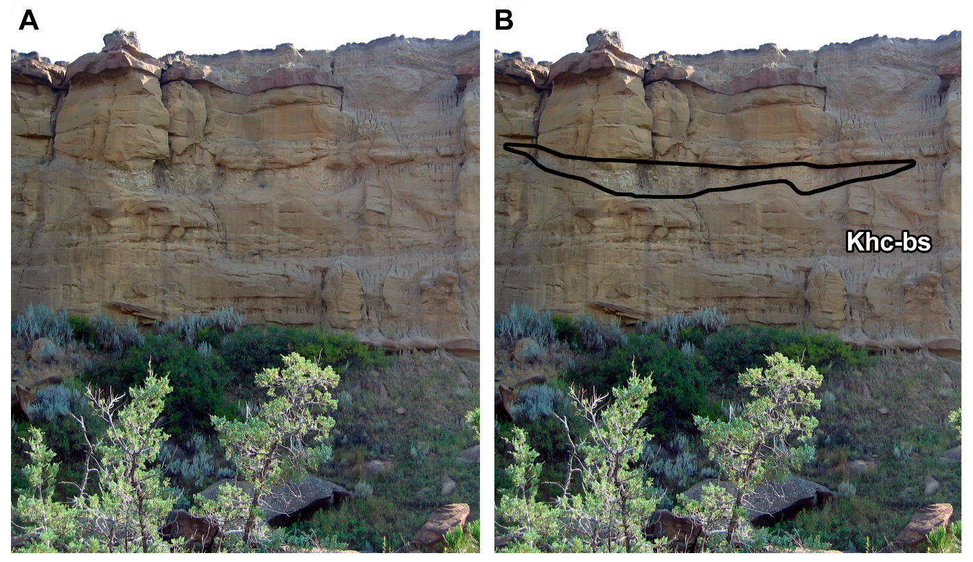
3.1.6. Hell Creek Basal Sand (Khc-bs)
The Basal Sand is an amalgamated channel complex of variable thickness (0–15 m) that is usually present as the basalmost unit of the Hell Creek Formation. Normally the contact with the underlying Colgate units is non-incising (Figure 4, Figure 5 and Figure 10), but is occasionally marked by an erosive scour (Se; up to 5 m depth; Figure 10). However, scouring is relatively rare and very localized in nature, perhaps explaining how it was not observed by Flight [20], although it was mentioned by Brown [5,6] and Jensen and Varnes [33], who described incisions up to 10 m. Geometry is sheet-like, and although laterally continuous over many kilometers, thickness varies [5], being up to 15 m, but generally 5 m or less. The Basal Sand varies from mid-pale grey through to tan or brown. In contrast to the fine grain size of the underlying Colgate Sandstone, the Basal Sand is usually medium to coarse grained at its base, fining upwards, and exhibits a “peppered” appearance which strongly distinguishes it from Colgate or Fox Hills Sandstones [33]. Bedding consists of inclined heterolithic strata (Sihs; especially near the base; Figure 7), trough cross-bedded sandstone (St; more common), massively bedded sandstone (Sm), ripple cross-laminated sandstones (Sr), and occasional interbedded siltstones and mudstones (Fml). Conglomerate channel lags are occasionally observed within the lower 2–3 m, and comprise weathered bone and mudstone clasts typically < 2 cm in diameter, but occasionally up to 10 cm. Concretions are frequent and sometimes large, on the scale of meters. Where present, the upper 1–2 m of the Basal Sand fine upward rapidly and are overlain by a package of fine-grained sediments and isolated channels: the lower Hell Creek Formation fines.
3.1.7. Lower Hell Creek Formation fines (Khc-lf)
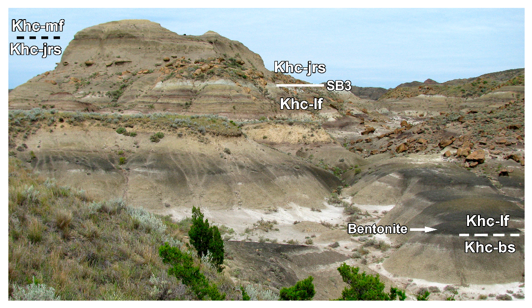
The lower Hell Creek Formation fines are a variable package of typical overbank fluvial sediments comprising mudstones (Fml), organic-rich mudstones (C), crevasse splay sandstones, siltstones (Fml), and isolated channel facies (St, Sr, Sm; Figure 4, Figure 5 and Figure 6, Figure 10, Figure 11, Figure 12, Figure 13 and Figure 14). Mudstones are variegated, banded, often bentonitic, and typically “somber” [5] low-chroma shades of grey, brown, purple, or green. Organic-rich shales are common, red-brown in color, laminated, and friable. Infrequent channel sandstones are isolated and typically finer grained than the amalgamated channels of the Basal and Jen Rex Sands that bracket Khc-lf. Individual beds are typically lenticular in geometry and rarely traceable over any more than a kilometer. Repeated packages of a basal fine crevasse splay sandstone or siltstone that fines upwards through a massive mudstone, and finally an organic rich shale, are common and interpreted as stacked paleosol successions [112]. Thickness of the lower Hell Creek Formation fines is variable (in part due to the varying incision depth of the overlying Jen Rex Sand), typically ~15 m (19.2 m in the new type section; [10]), although this can be as little as 2–3 m [20].
3.1.8. Jen Rex Sand (Khc-jrs)
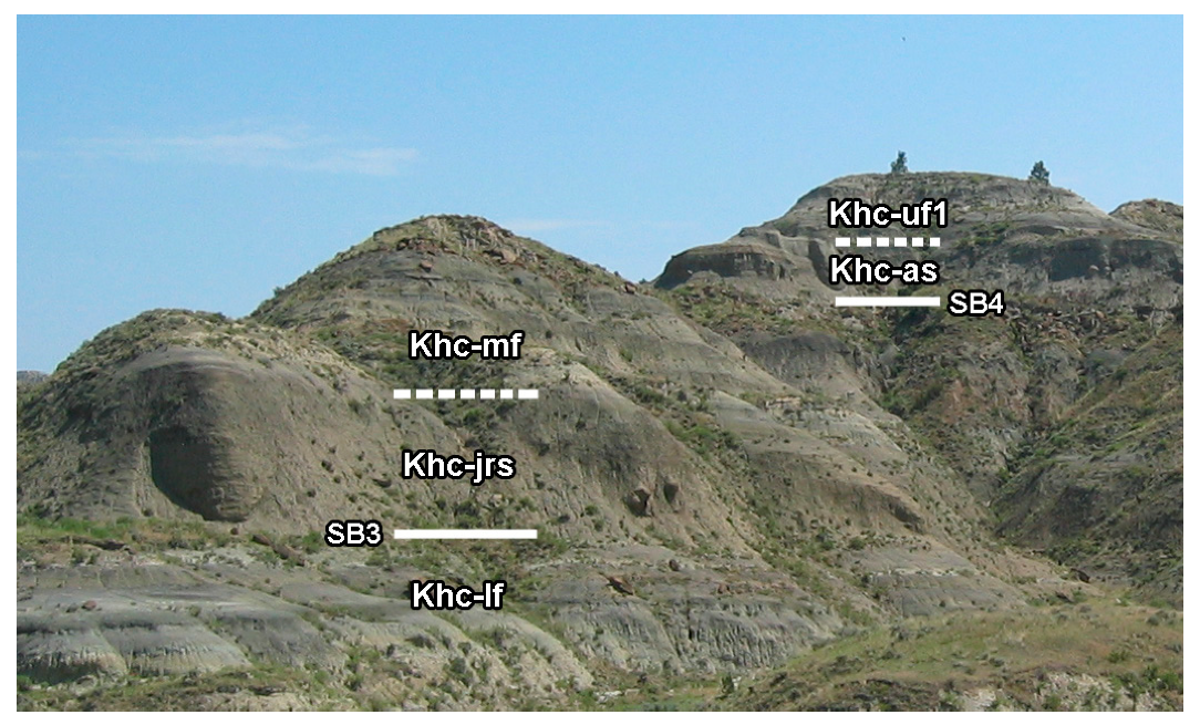
The Jen Rex Sand is an amalgamated channel complex that generally occurs ~15 m above the top of the Basal Sand, immediately overlying the overbank fines and isolated channels of the lower Hell Creek Formation (Khc-lf). This contact is highly variable, and as a consequence the thickness of the Jen Rex Sand is similarly variable. The contact is usually marked by an erosive scour, with depth variation highly localized, usually from 0–5 m, but up to 15 m [20]. Geometry of the Jen Rex Sand is sometimes channelized in lower parts but is otherwise sheet-like and can be laterally continuous over several kilometers. Thickness varies, and is usually 5–6 m but is often much thicker, up to 12 m (11.9 m in the new type section [10]; Figure 6, Figure 11, Figure 12, Figure 13 and Figure 14), giving it the greatest maximum thickness of the Hell Creek Formation amalgamated channel complexes. The Jen Rex Sand is typically tan or brown colored, often with large (0.5–3 m) prominent orange concretions (Figure 4, Figure 5, Figure 11, Figure 12, Figure 13 and Figure 14) and exhibits a “peppered” appearance similar to the Basal Sand. Usually, the basal erosive scour is overlain by a medium to coarse-grained sandstone, or occasionally coarse conglomerate lenses comprised of mudstone pebbles up to 15 cm diameter. Some localities have a bone lag immediately overlying the erosive scour. Indeed, the Jen Rex Sand is named after Tyrannosaurus rex bones found by Jennifer Flight in the basal lag. Grain size is typically medium at the base of the unit, then shows a general fining upward trend. Bedding consists of trough cross-bedded, planar bedded, and massive sandstones. In its uppermost ~2 m the Jen Rex Sand fines into siltstone and is overlain by fines and isolated channels of the middle Hell Creek Formation fines.
3.1.9. Middle Hell Creek Formation Fines (Khc-mf)
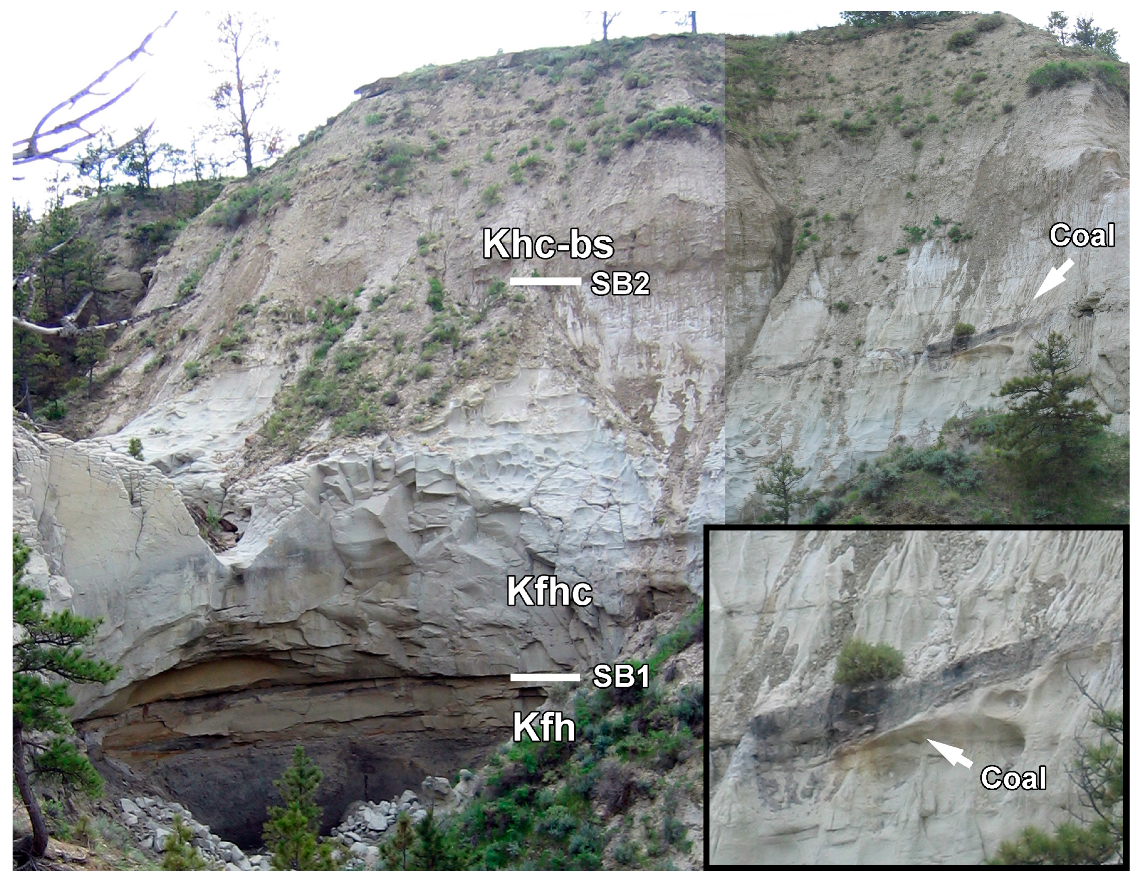
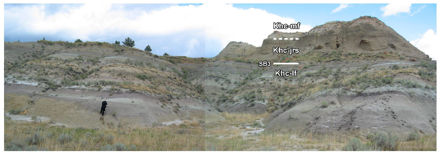
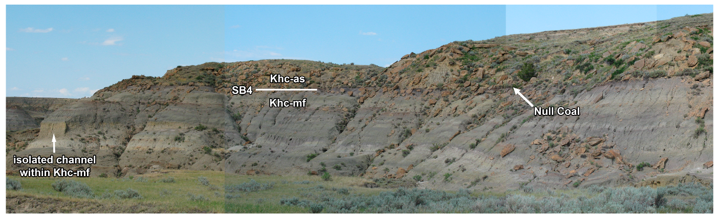
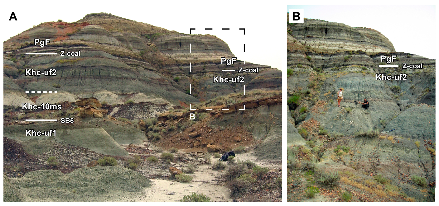
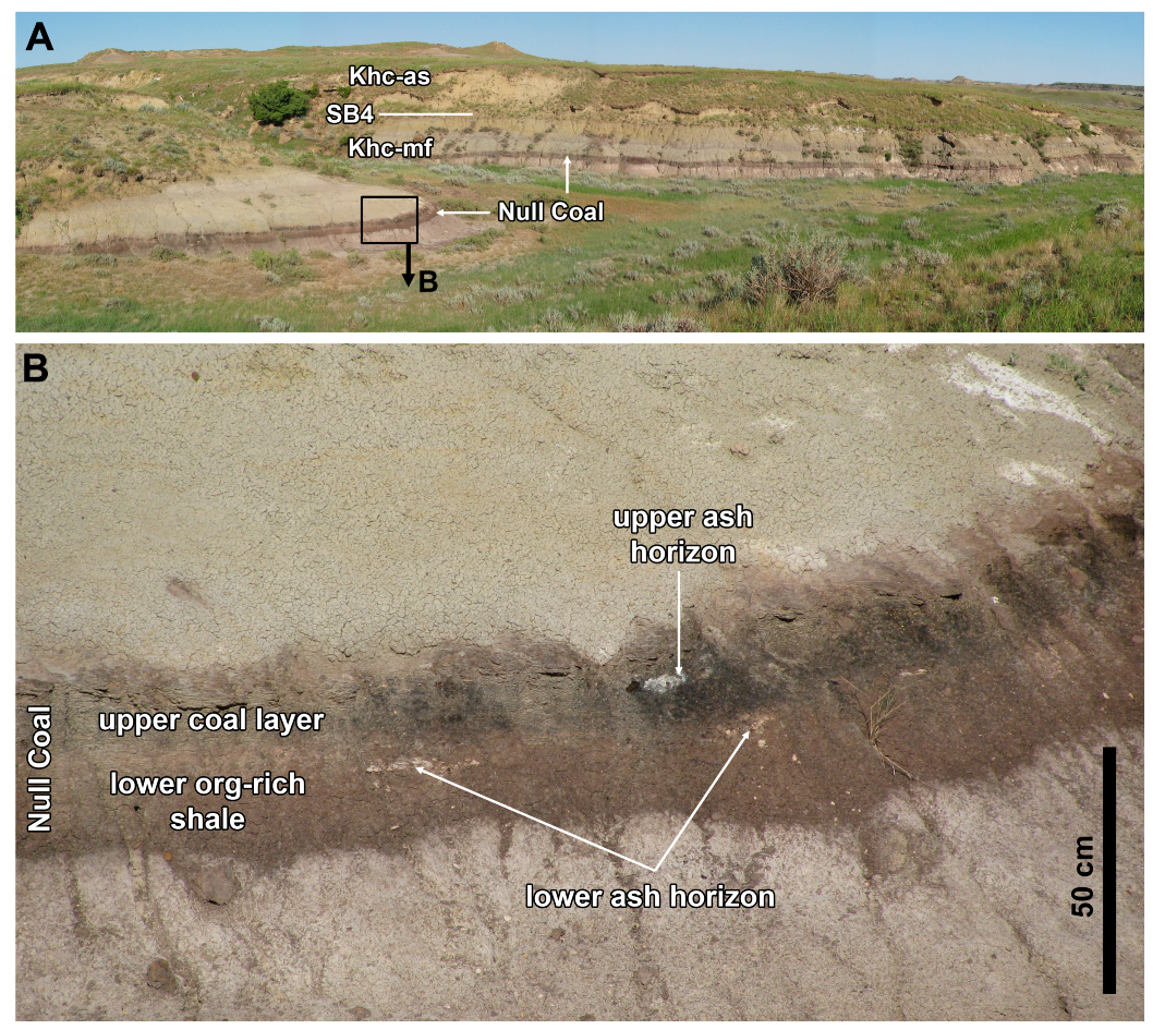
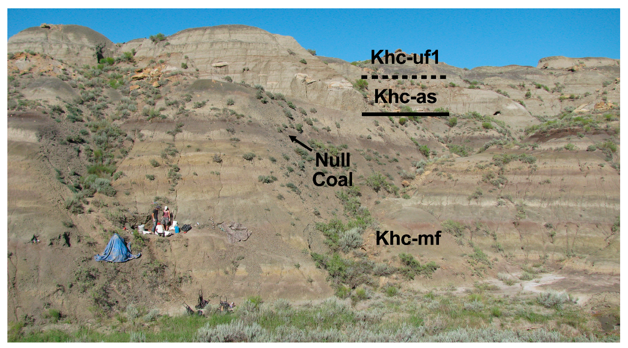
Immediately overlying the Jen Rex Sand is a ~20–30 m package of fine-grained overbank facies. Facies descriptions are the same as the lower Hell Creek Formation fines (see above). Usually, the middle fines are thickest of the fine-grained units, being ~30 m thickness (25.3 m in the new type section [10]), but can be up to 35 m (e.g., Penick Coulee, Figure 14 and Figure 15; Lost Creek, Figure 16 and Figure 17). In some localities (e.g., Bug Creek; Lost Creek, Figure 16; East Gilbert Creek, Figure 15 and Figure 18), the top of the middle fines is marked by an unusually thick organic-rich unit; this takes the form of either an organic rich mudstone with root traces, or a coal horizon. This is the Null Coal (or equivalent organic-rich shale) and is the only coal horizon present within the Hell Creek Formation of Montana. The Null Coal contains two dated ash horizons [19,76]. The Null Coal is ~1 m thick in western McCone County (e.g., Bug Creek [14]), but thins to the west, being ~50 cm in eastern Garfield County (East Gilbert Creek), where it may be replaced by an organic shale, or only the lower half is organic shale, maintaining an upper ~25 cm of coal.
3.1.10. Apex Sand (Khc-as)
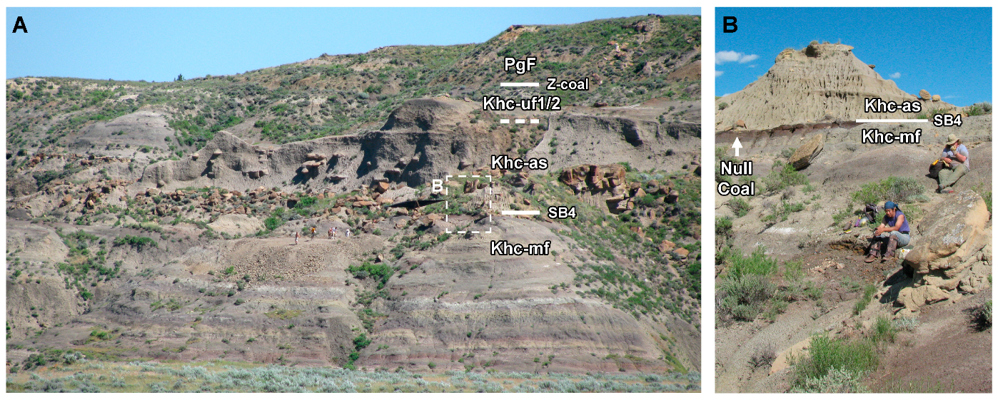
The Apex Sand is an amalgamated channel complex that generally occurs ~26–30 m below the upper formational boundary (Figure 6, Figure 12, Figure 16, Figure 18 and Figure 19). It erosively overlies the middle Hell Creek Formation fines (Khc-mf), albeit without any significant relief. Geometry is sheet-like and laterally continuous over several kilometers. Thickness is ~4–6 m (6 m in the new type section [10]). The Apex Sand is typically tan or brown, with occasional concreted horizons, and exhibits a “peppered” appearance similar to the Basal Sand. Grain size is usually medium at the base of the unit, quickly fining upwards with an overall fining upward trend. Bedding consists of trough cross-bedded, planar-bedded, and massive sandstones. It commonly yields macrovertebrate and microvertebrate fossils, often disarticulated and abraded, although partly articulated unabraded material is known [24]. In its uppermost ~1–2 m the Apex Sand fines into a siltstone and is overlain by fine grained sediments and isolated channels of the upper Hell Creek Formation fines part 1.
3.1.11. Upper Hell Creek Formation Fines part 1 (Khc-uf1)
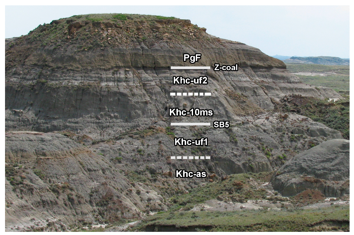
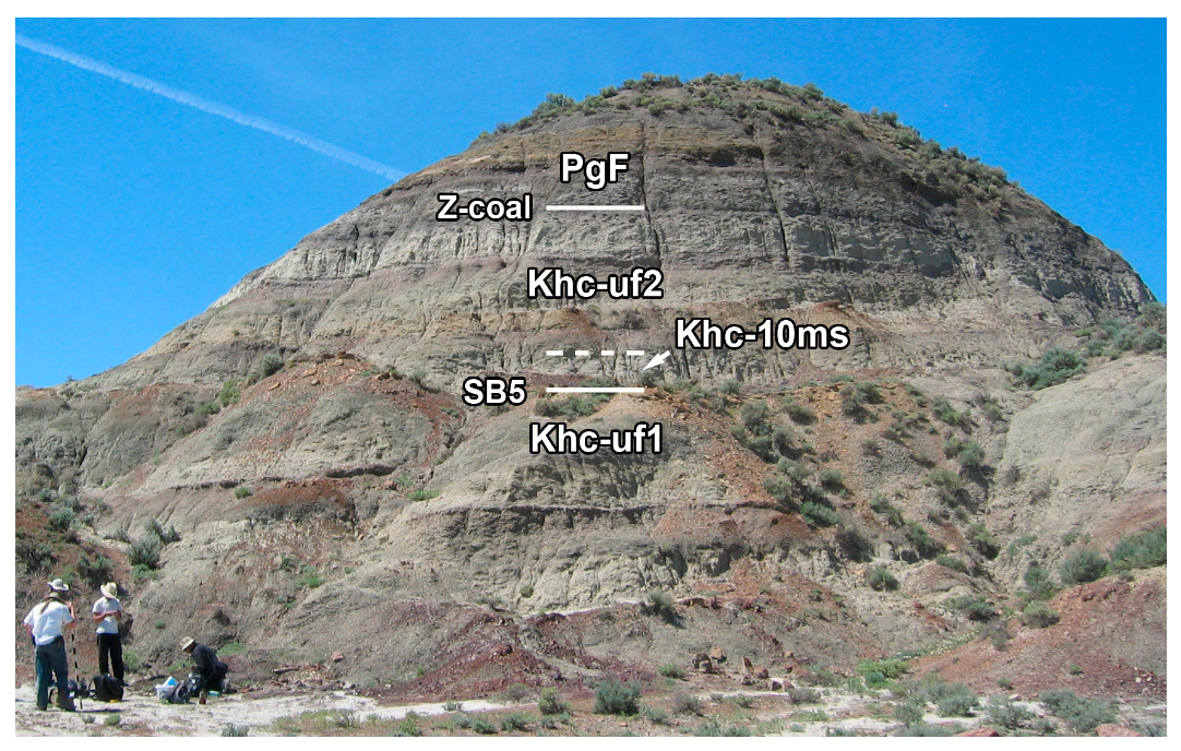
Immediately overlying the Apex Sand is a ~10–15 m package of fine-grained overbank facies (Figure 12, Figure 18, Figure 19, Figure 20 and Figure 21). Facies descriptions are the same as the lower Hell Creek Formation fines (see above). In areas where the 10 Meter Sand is not present, Khc-uf1 and Khc-uf2 are continuous. Rarely, a thick organic rich mudstone is present at the very top of Khc-uf1, immediately underlying the 10 Meter Sand.
3.1.12. Meter Sand (Khc-10ms)
The 10 Meter Sand is an amalgamated channel complex that (Figure 19, Figure 20, Figure 21, Figure 22, Figure 23 and Figure 24) derives its name from its usual occurrence ~10 m below the upper formational contact. It immediately overlies the overbank fines and isolated channels of the upper Hell Creek Formation (Khc-uf1). This contact is erosive, but rarely exhibits any significant relief (although it does incise ~10 m into the Apex Sand at the southern end of East Gilbert Creek; see below). Geometry of the 10 Meter Sand is sheet-like and often laterally continuous over several kilometers. The 10 Meter Sand is usually less thick than the other Basal, Jen Rex, or Apex sandstones, typically 4–5 m or less (4 m in the new type section [10]). It is typically tan or brown, with occasional concreted horizons, and is “peppered” in appearance. The 10 Meter Sand is a good source of fossil macro and microvertebrate material, sometimes partly articulated and relatively unabraded. It is usually medium to upper fine grained at the base, with a fining upward trend. Bedding consists of trough cross-bedded, planar bedded, and massive. The uppermost ~2 m of the 10 Meter Sand fines into a siltstone and is overlain by fine grained sediments and isolated channels of the upper Hell Creek Formation fines part 2.
3.1.13. Upper Hell Creek Formation Fines Part 2 (Khc-uf2)
Immediately overlying the 10 Meter Sand is a ~5–8 m package of fine-grained overbank facies (Figure 19, Figure 20, Figure 21, Figure 22, Figure 23 and Figure 24). Facies descriptions are the same as the lower Hell Creek Formation Fines (see above). The uppermost bed of Khc-uf2 is typically a thin grey leached mudstone or siltstone that is immediately overlain by a thin (<20 cm) coal, the first bed of the Fort Union Formation.
3.1.14. Fort Union Formation (PgF)
As this study concentrates on the Hell Creek Formation, only the lowermost parts of the Fort Union Formation are considered. The overlying Tullock member of the Fort Union Formation represents a conspicuous facies change, exhibiting numerous coals, with mudstones, siltstones, and sandstones that are a much deeper yellow than the somber beds of the Hell Creek Formation (Figure 18, Figure 19, Figure 20, Figure 21, Figure 22, Figure 23 and Figure 24). The first coal horizon marks the formational contact with the underlying Hell Creek Formation. This is usually very thin (<20 cm), laterally inconsistent, and not always immediately obvious in section; however, the coal horizons usually ~1–2 m above it (the Z-coal complex) are up to 1.4 m thick (typically~50 cm) and are more prominent but laterally inconsistent [4,18], sometimes splitting into upper and lower Z-coals, and referred to by a number of names (HFZ, MCZ, Z, IrZ; [4,19]). Other than coal horizons, basal facies of the Fort Union Formation are quite variable. The thicker coal horizons may be absent, and in their place a banded “variegated” siltstone facies [11,45], or yellow channel sandstones (some of which incise deeply into the Hell Creek Formation; e.g., [14]).
3.2. Study Localities and Measured Sections
The following sections are described in stratigraphic order, geographically roughly west to east. Emphasis is placed on well exposed outcrop and unusual features. All localities are in Garfield County, Montana, unless otherwise stated (Figure 1 and Figure 2).
3.2.1. Drainage of Crooked Creek, North of Winnett, MT
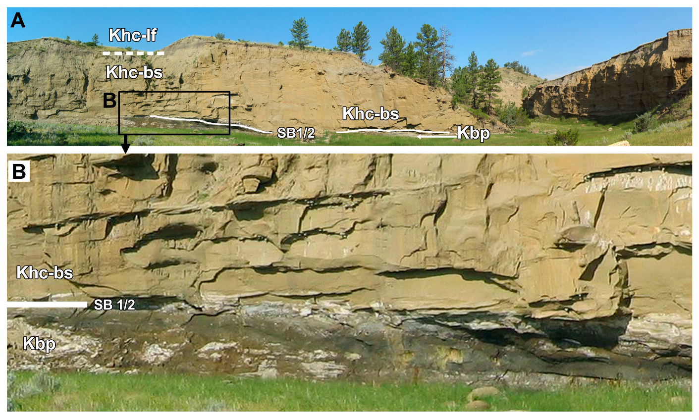
The Colgate Sandstone is well exposed and accessible ~46 km north of the small town of Winnett (Petroleum County, ~120 km west of Jordan; Figure 1). This area was surveyed by Flight [20] and was the principal study area for Behringer [43]. At Crooked Creek (Figure 7, Figure 8 and Figure 9; 47°24′13′′ N, 108°14′35′′ W; NAD27CONUS; a slightly more easily accessible section is observable only 200m from the road at 47°24′24′′ N 108°13′14′′ W, NAD27CONUS) the Colgate Sandstone is unusually thick for the Ft. Peck area (up to 12 m, compared to more typical 2–5 m). The erosive contact with the underlying Fox Hills Sandstone is sharp, and of variable incision depth. Elsewhere in this area north of Winnett, the Colgate Sandstone incises completely through the Fox Hills Sandstone, and into the Bearpaw Shale [20,43]. The Colgate Sandstone exhibits the same two-tone coloration as seen in other sections but differs in the thicknesses of each individual unit. The lower tan-grey unit is 4m thick and is overlain by 8 m of the pale grey unit, which weathers into the distinctive bold white characteristic of the Colgate Sandstone (Figure 7 and Figure 8). The Colgate tidal flats are not obviously visible here. Instead the Colgate Sandstone is overlain by the Hell Creek Formation Basal Sand (~4 m thick).
3.2.2. Cole Creek, Near Hell Creek Marina, North of Jordan, MT
The steep cliffs of Cole Creek (47°38′26′′ N, 106°55′25′′ W; NAD27CONUS; Figure 25) expose the Bearpaw Shale through to Jen Rex Sandstone of the Hell Creek Formation. The Colgate Sandstone is absent, but the Colgate tidal flats are present, represented by the lower grey siltstone (2 m), and overlain by a thin (20 cm) organic-rich mudstone. There is no obvious deep erosional scour at the base of the overlying Hell Creek Basal Sand, although it is thick here (12 m), and subsequently overlain by 8 m of overbank fines. These are in turn overlain by the resistant Jen Rex Sandstone that forms a steep 8 m cliff capping the section. Here, the base of the Jen Rex Sand contains a bone lag from which some relatively large dinosaur bones have been collected. Nearby, 0.5 km southwest (47°38′12′′ N, 106°55′40′′ W; NAD27CONUS) the Jen Rex Sand incises deeply into the underlying strata (~10 m), and similarly exhibits an unusually coarse conglomerate at its base, with angular mudstone clasts 10–15 cm across.
3.2.3. Hell Creek, Near the Marina Road (FWS-105), North of Jordan, MT
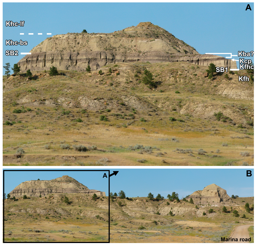
The transition from the Bearpaw through to the Hell Creek Formation is well exposed at Hell Creek itself, with easily accessible near-continuous outcrop along the Hell Creek Marina Road (FWS-105). Here I briefly describe four sections which change from a typical or normal section in the north at “Best Butte” (and the Hell Creek State Park), to an atypical (but commonly described) section south at “Manaige Spring”. Interpretation differs significantly between authors [10,20,28], with important implications, not the least that a small part of the Battle Formation may be exposed in this area [28].
3.2.4. “Best Butte” & “Hike Cliff”
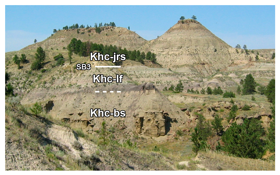
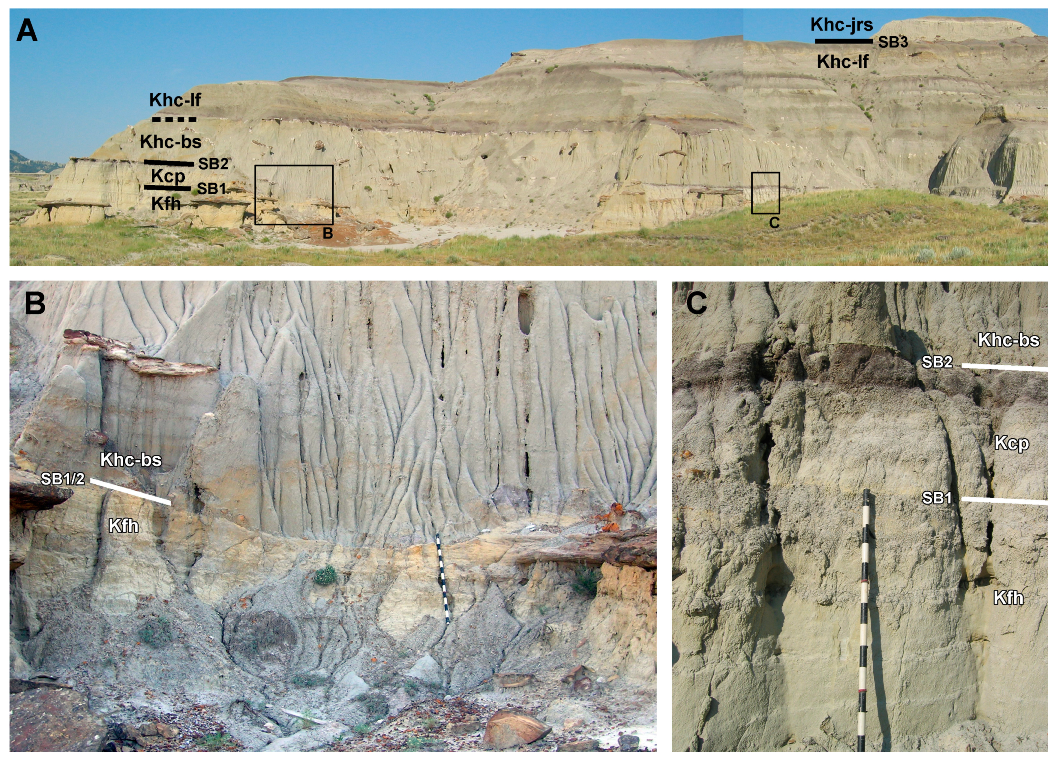
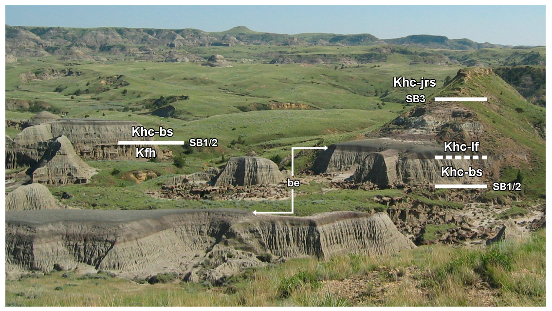
Two sections immediately adjacent to each other record comparable stratigraphy, considered here as “typical” for the Hell Creek Formation in this area; “Hike Cliff” (Figure 4; 47°36′5′′ N, 106°55′14′′ W, NAD27CONUS) and “Best Butte” (Figure 26; 47°35′36′′ N, 106°54′50′′ W, NAD27CONUS; section #10 in Flight [20]). In both buttes the pale grey silty sandstones of the upper Bearpaw Shale grade into the conspicuous yellow Fox Hills Sandstone (forming a gradual slope). This is abruptly overlain by a relatively thin (~4 m) cliff-forming sandstone, conspicuously more pale than the Fox Hills Sandstone, lacking concretions, and capped by a thin grey siltstone and prominent purple mudstone (consistent with the appearance and stratigraphic position of the Colgate Sandstone and Colgate tidal flats in the Manaige Spring section; Figure 5). At Best Butte and Hike Butte however, the Colgate tidal flats are directly overlain by a cliff-forming amalgamated channel sandstone, identified here as the Hell Creek Basal Sand. Concretions in the Basal Sand can be seen clearly in the lower ~4–5 m, but absent from the upper ~6 m (the Basal Sand thickens northwards so that in the cliffs immediately west of the Hell Creek Marina it achieves considerable thickness of ~12 m or more, and inclined heterolithic strata are clearly visible in the upper 3–4 m). The Basal Sand is overlain by typical banded mudstones of the lower Hell Creek Formation fines, although these vary in thickness between Hike Cliff and Best Butte. At Hike Cliff, the lower fines are ~10–15 m thick with the section capped by the Jen Rex Sandstone (Figure 4). At Best Butte the lower fines are only ~4 m thick and are then capped by a sand unit which probably is an isolated channel sand (Figure 26).
It is important to note that in Hartman et al. [10], Best Butte (their supplementary Figure DR85) is interpreted differently, with the white sandstone (identified above as the Colgate Sandstone), named as the Hell Creek Basal Sand, and the overlying major sand unit (identified above as the Basal Sand) referred to the Jen Rex Sand. These stratigraphic referrals are here considered incorrect, with error resting upon the misidentification of the Colgate Sandstone. This is likely because the photograph of Best Butte used by Hartman et al. [10] (supplementary Figure DR85) does not include the smaller butte seen on the left of the main butte (see Figure 26). This smaller butte clearly exhibits the characteristic striking white weathering of the Colgate Sandstone.
3.2.5. Manaige Spring and “Battle Butte”
The Marina Road crosses Hell Creek itself at Manaige Spring (47°34′15′′ N, 106°57′0′′ W; NAD27CONUS; Figure 5), where the transition from the Bearpaw Shale to Hell Creek Formation is atypical and has been interpreted differently among authors [10,28], notably in the identification of a white-colored sandstone near the base. Observation of sections further north along the Marina Road (Hike Butte and Best Butte) allows correlation with the Manaige Spring section, and confirmation that this white-colored sandstone is the Colgate Sandstone.
At Manaige Spring, the Bearpaw Shale grades into the Fox Hills over ~10 m. The Fox Hills Sandstone is overlain by an 8 m thick pale sandstone, which weathers into a distinctive rilled pattern, strikingly different from the blocky weathering of the Fox Hills. This pale sandstone is visibly divided into two color bands, with the upper band a paler shade of grey. This sand unit was identified as the Colgate Sandstone by Lerbekmo [28]. However, Hartman et al. [10] (supplementary information) disagree with Lerbekmo ([28]; and the current analysis), identifying this pale sandstone instead as the Basal Sand of the Hell Creek Formation, citing (p. 54) that the “white coating (alkaline deposits) is not present laterally (yellowish gray Hell Creek sandstone beds)”. However, this is in error as a Colgate Sandstone identification is corroborated by the same horizon visible at Best Butte (see above; Figure 26) where it exhibits the characteristic striking white weathering pattern.
The upper band of the Colgate Sandstone fines upwards into the Colgate tidal flats: a 50 cm grey siltstone capped by a 50 cm purple-brown organic rich muddy siltstone. Above the Colgate tidal flats is an unusual package of facies not encountered anywhere outside of this local area (see also Battle Butte and Eastside Overlook, below). Instead of the Basal Sandstone there is a conspicuous leached siltstone (30 cm thick), overlain by a 30 cm thick dark organic rich siltstone. The siltstone is a deep red-brown to black color with much organic debris, including twigs and rootlets. This horizon is similarly present, but as a medium grained sandstone ~1.5km east near the mouth of Jordan Coulee (pers. obs.; [58]). Above the organic siltstone are ~10 m of mauve, purple, and grey-green mudstones. These beds are here tentatively referred to the Battle Formation, consistent with their stratigraphic position [111], lithofacies ([110]; see Supplementary Materials), and preliminary palynostratigraphic analysis [28]. The possible Battle Formation is overlain by the Basal Sand of the Hell Creek Formation (~9 m thick), which forms the uppermost unit of this section.
“Battle Butte” (47°34′43′′ N, 106°56′39′′ W; NAD27CONUS; Figure 27) occurs at the roadside ~1 km NNE of Manaige Spring, and records a stratigraphic succession intermediate between Manaige Spring and Best Butte (located ~3 km NE). The lowermost visible unit is the transitional grey silty sandstone between the Bearpaw Shale and Fox Hills Sandstone, forming a gradual slope at the base of the butte. These are overlain by the orange sandstone of the uppermost Fox Hills (~20 m in total relief). Overlying the Fox Hills is a pale colored cliff forming sandstone capped by an organic rich horizon. This is interpreted here to be the Colgate Sandstone and tidal flats, but was interpreted by Hartman et al. [10] (supplementary Figure DR84) as the Basal Sand of the Hell Creek Formation (in error; see above). Overlying the Colgate tidal flats is a thin exposure of the possible Battle Formation, which is ~3 m thick on the western edge of the butte (left side of Figure 27B), but is absent at the small butte closest to the road (right side of Figure 27B), having been completely removed by incision of the overlying Basal Sand of the Hell Creek Formation. Hence this locality records the removal of the possible Battle Formation facies, to leave the direct contact of the Hell Creek Formation Basal Sand upon the Colgate Sandstone (and/or tidal flats) that is observed to the north (e.g., Best Butte; see above). The overlying Hell Creek Basal Sand is ~6 m thick and exhibits some inclined heterolithic strata, fining upwards into a package of 5–6 m of mudstones of the Hell Creek lower fines.
3.2.6. East Ried Coulee, Flag Butte (New Type Section)
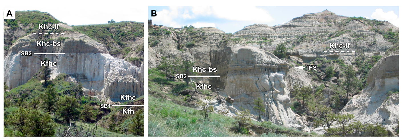
The new type section for the Hell Creek Formation is located at Flag Butte, near East Ried Coulee (47°33′34′′ N, 106°52′52′′ W, NAD27CONUS), ~5 km east of the Marina Road (FWS-105), and is described in detail by Hartman et al. [10]. However, the basal contact of the Hell Creek Formation defined by Hartman et al. [10] is probably incorrect. However, it should be noted that the stratigraphic relationships immediately below the basal contact of the Hell Creek Formation Basal Sand are very complex and easy to misinterpret.
The deep ravine at East Ried Coulee exposes the Bearpaw Shale at its base with continuous exposure through to the top of nearby Flag Butte (~1 km SE; 47°33′22′′ N, 106°52′8′′ W, NAD27CONUS), which is capped by the lowermost 10 m of the Fort Union Formation (Hartman et al., 2014). The steep walls of East Ried Coulee are mostly composed of ~20 m of tan to orange colored medium to coarse-grained sandstone (Figure 6, Figure 28, Figure 29 and Figure 30). The base of these cliffs exposes horizontally stratified or massively bedded grey silty sandstone, here attributed to the transitional beds of the Bearpaw Shale (Figure 28). Identity of the silty sandstones as the transitional beds of the Bearpaw Shale is supported by magnetostratigraphic analysis (LeCain et al., 2014; Lerbekmo, 2009; see later discussion).
These basalmost beds of the succession are not figured in the sections measured by Hartman et al. [10], yet are critical to interpretation. The overlying tan to orange colored sandstones are referred to the Fox Hills Sandstone by Hartman et al. [10], and this would seem to be consistent with their stratigraphic position. However, the base of these tan-orange sandstones is erosive and has an abrupt contact with the underlying silty sandstones of the Bearpaw Shale (Figure 28): an erosive relationship between the Fox Hills Formation and Bearpaw Shale has not been observed elsewhere, nor noted by other workers. Furthermore, the tan-orange sandstone exhibits large scale trough cross-bedding, medium to coarse sand grain size, fining upwards successions both within individual beds and overall though the unit, possible inclined heterolithic strata (Figure 29), internal scour surfaces at the bases of distinct channels sometimes infilled with conglomerate (Figure 30; Hartman et al. [10], supplementary Figures DR36-37; Rogers, pers. comm. 2014), and has a “peppered” texture [33], none of which are observed in the Fox Hills Formation, but are characteristic of the Basal Sand of the Hell Creek Formation. Therefore, this unit is not referable to the Fox Hills Formation, and instead probably represents the Hell Creek Formation Basal Sand which is unusually thick at this location as it has incised down through the Colgate Sandstone (if originally present) and Fox Hills Formation into the transitional beds of the Bearpaw Shale. In their supplementary materials, Hartman et al. [10] document that this view was shared by A. G. Leonard ([113]; who visited East Ried Coulee with Barnum Brown) who stated that “The basal sandstone of the Laramie [Hell Creek] is finely exposed in the gorge at the headwaters of the East Fork of Hell Creek [Ried Coulee] where it has the exceptional thickness of 150(?) feet [45.7 m]”. Thus, it would appear from this account that Leonard agreed that the thick sandstone present in Ried Coulee is the Basal Sand of the Hell Creek, and not (mostly) the Fox Hills Sandstone (i.e., sensu Hartman et al. [10]). This referral is also supported by palynomorphs extracted from the tan-orange sand unit which show affinity with those of the Hell Creek Formation (Braman, pers. comm. 2012).
The Basal Sand of the Hell Creek Formation fines upwards in the upper 5 m and changes from tan-orange color into a pale sandstone overlain by a thick organic rich mudstone (Figure 6). This is unusual for the Basal Sand, although a similar stratigraphic relationship is observed at the northern edge of Penick Coulee (see below), where an organic shale immediately overlies the top of the Basal Sand.
Regardless of the identity of the basal units, further overlying subunits of the Hell Creek Formation (beginning with the lower Hell Creek Formation Fines) are typical in occurrence and thickness (Jen Rex Sand is 19.2 m above the top of the pale sandstone; Apex Sand is 25.3 m above the top of the Jen Rex Sand, 10 Meter Sand is ~9 m below the Hell Creek—Fort Union formational contact; Figure 11 and Figure 12). In conclusion, the type section exhibits an unusual basal contact of the Hell Creek Formation, but is otherwise typical.
3.2.7. Sand Creek, Sheep Mountain, Carter County MT
A small outcrop in Sand Creek (55 km southeast of Ekalaka, Carter County, Montana; 45°30′8′′ N, 104°8′0′′ W, NAD27CONUS) records the transition from the Fox Hills Sandstone through the lower 30 m of the Hell Creek Formation (Figure 10 and Figure 31), and is lithostratigraphically comparable to sections in the Ft. Peck area, 300 km northwest. The section begins with the uppermost 3 m of the Fox Hills Sandstone, which is typically yellow in color and in its upper 1 m exhibits prominent orange-colored concreted sandstone lenses with ripple cross-lamination. The Colgate Sandstone is absent here, instead, the Fox Hills Sandstone is irregularly overlain by the Colgate tidal flats (Figure 10) consisting of a 50–60 cm thick grey silt, overlain by 20–30 cm of purple-brown organic-rich silty mudstone. This is overlain in turn by the 10 m thick Basal Sandstone of the Hell Creek Formation. The variable nature of this contact is of particular interest. Typically, the Basal Sand lies disconformably on top of the organic rich horizon of the Colgate tidal flats. However, in places (Figure 10B) the Basal Sand has eroded down ~3 m through the Colgate, and into the Fox Hills Sandstone. With the limited outcrop and time spent in this area, it was not possible to trace the contact further, but it illustrates the occasionally incising nature of the Hell Creek Basal Sand. 13–17 m of overbank fines overlies the Basal Sand, followed by the Jen Rex Sand that caps the succession at this locality.
3.2.8. East Gilbert Creek and Penick Coulee
Excellent badland exposures at the headwaters of East Gilbert Creek (47°41′13′′ N, 106°31′44′′ W; NAD27CONUS) north into Penick Coulee (47°43′51′′ N, 106°30′23′′ W; NAD27CONUS) represent one of the few localities where a complete section from the Bearpaw Shale to Fort Union Fm can be observed in easily accessible BLM-administered land (Figure 15). On the southern edge of East Gilbert Creek, and immediately north of the Haxby Road (47°39′6′′ N, 106°30′59′′ W; NAD27CONUS), a 5 km SW-NE trending cliff exposes the upper 10–20m of the Hell Creek Formation and upper contact with the Fort Union Formation. At the Isaac’s ranch the cliff turns north and the exposure deepens into the wash, exposing the Fox Hills Sandstone and uppermost Bearpaw Shale. The East Gilbert Creek section is typical in the presence of the Basal Sandstone, Jen Rex Sandstone, Apex Sandstone, and 10 Meter Sandstone in their expected positions. Of interest is an especially thick (30 cm) organic-rich mudstone that occurs immediately below the Apex Sand (Figure 18; 47°41′32′′ N, 106°30′47′′ W, NAD27CONUS); this is in the same stratigraphic position as the Null Coal, but does not preserve any volcanic ash. A Null Coal exposure 1.5 km to the southeast (47°40′48′′ N, 106°30′16′′ W, NAD27CONUS) contains both upper and lower ashes. At this locality the upper ash is contained within a coal, but the lower ash is within a red organic rich shale (by comparison, both ashes are within coals in Bug Creek ~25 km to the east; [14,19,76]). This suggests that coal swamp conditions spread westwards (landward) between the deposition of the lower and upper ashes. The southern part of East Gilbert Creek is also one of the few localities where the 10 Meter Sand can be observed with any incision depth. At the same locality as the above Null Coal (47°40′48′′ N, 106°30′16′′ W, NAD27CONUS) the 10 Meter Sand incises ~ 10 m into the top of the Apex Sand, to create a combined sandstone thickness of ~18 m.
In contrast, if the continuous outcrop is followed north into Penick Coulee the section becomes atypical in a number of respects. In north Penick Coulee, the Basal Sandstone (8 m thick) is extensively exposed forming a prominent bench (Figure 13 and Figure 14), and contains unusually large quantities of silicified wood. The Basal Sand is overlain by an organic-rich red mudstone, and a conspicuous popcorn-weathering dark gray-green bentonite (Figure 13 and Figure 14; this has been sampled for radiometric analysis). The bentonite is 1.5 m thick at the northern extent of Penick Coulee, but thins southwards and was not observed in East Gilbert Creek. In northwest Penick Coulee (Figure 14, section 1; 47°43′50′′ N, 106°30′01′′ W NAD27CONUS) the Jen Rex Sand is typical and prominent, 15 m above the top of the Basal Sand, but it thins rapidly and is not traceable 0.5 km east (Figure 15, sections 2 and 3). However, it is again present ~ 1km south, in the middle of the coulee (Figure 13). Similarly, the Apex Sand is atypically thin or absent in northern to middle parts of Penick Coulee, although in southern Penick Coulee it is present. In addition, in Penick Coulee the Z-coal and K-Pg boundary have sometimes been removed by channeling that incises down from the Paleocene (Figure 15, section 3; similar to incised channels in Bug Creek, Carter County, ~50 km East; [14,114]; see later). As in Bug Creek, the Penick Coulee channels exhibit reworked coal at their base; however, they only incise ~10 m below the Hell Creek-Fort Union formational contact (compared to ~35 m at Bug Creek). Consequently, since the upper contact cannot be determined, the complete thickness of the section in Penick Coulee is not precisely known.
3.2.9. Gilbert Creek
Gilbert Creek (47°38′11”N, 106°36′14”W, NAD27CONUS) is an extensive area of badlands exposing the upper 50–60 m of the Hell Creek Formation (although exposures probably reach lower in section on adjacent Charles M. Russell Reserve land), and upper contact with the Fort Union Formation. Only the uppermost part of the Hell Creek was surveyed as part of this analysis, although prospecting for vertebrate fossils was conducted deep into Gilbert Creek (preliminary surveying of BLM land in 2010). Gilbert Creek exposures are continuous with East Gilbert Creek, but the connecting area of outcrop has yet to be investigated. The 10 Meter Sand and Apex Sand are present in Gilbert Creek, and have yielded some important vertebrate fossils [24].
3.2.10. Lost Creek
Extensive outcrop in Lost Creek (Figure 16, Figure 17 and Figure 19; 47°40′10′′ N, 106°19′13′′ W, NAD27CONUS) exposes the upper ~50 m of the Hell Creek Formation through to the lower ~10 m of the Fort Union Formation (over a traverse of ~2 km). Outcrop is often of moderate to high relief and continuous, giving excellent exposure of the contacts of the Apex Sand, 10 Meter Sand, and Fort Union Formation. The base of Lost Creek exposes the lowermost middle Hell Creek Formation Fines, with no obvious outcrop of the Jen Rex Sand, although isolated channels are present in some sections (Figure 16). The middle Hell Creek Fines are at least 35 m thick here, and are overlain by the Apex Sand (4–8 m thick). The Apex Sandstone is laterally extensive over the entire local area: 3–4 km2, and in most sections (e.g., Figure 16 and Figure 17) is underlain by a prominent and well developed organic-rich mudstone and/or coal horizon, here correlated to the Null Coal [14,19]. The Hell Creek Upper Fines Part 1 are ~13 m thick and overlain by the 10 Meter Sand (up to 6 m thick; Figure 19). There is only limited outcrop of the 10 Meter Sand, as most of the exposures are stratigraphically lower in section, such that the 10 Meter Sand tends to be exposed only at the tops of small buttes. Despite limited outcrop, the 10 Meter Sand is quite fossiliferous in this area, yielding associated and partly articulated dinosaur remains. Neither the Apex Sand nor 10 Meter Sand show any significant erosional relief at their bases.
3.2.11. Cottonwood Creek
A limited area of study in Cottonwood Creek (~1 km northwest of Brownie Butte; 47°31′58′′ N 107°1′17′′ W, NAD27CONUS; Figure 32) exposes the Apex Sand through to the Fort Union Formation. Approximately 2 km north of this, Cottonwood Creek feeds into Hell Creek, where exposures record the full thickness of the Hell Creek Formation. Brownie Butte has been subject to a number of studies, mainly focusing on the K-Pg boundary [45,50,115,116]. The Apex Sand is ~4–5 m thick here and has a claystone pebble conglomerate at its base, interpreted as a channel lag. Locally this unit contains well-preserved macrovertebrate fossils mixed in with the pebble clasts [24]. Limited exposure of the Apex Sand limits assessment of its continuity; however, Fastovsky [45] documented that the 10 Meter Sandstone pinches out at Brownie Butte itself, but thickens northwards to 5.7 m in Cottonwood Creek. It is also notable that at the old Trumbo ranch area (Hell Creek; 47°33′26′′ N, 107°0′50′′ W, NAD27CONUS) the Basal Sand is unusually thick, forming steep cliffs over 10 m high (also noted by Brown [5]).
3.2.12. Short Creek
The area of Short Creek has good exposures of the upper 30 m of the Hell Creek and Fort Union formational contact (Figure 20, Figure 22 and Figure 33). The deepest part of the wash exposes the upper 3–4 m of the middle Hell Creek fines, which are overlain by the laterally extensive Apex Sand (5 m thick). The contact is erosive but shows no significant relief. In most areas where it is exposed, the Apex Sand has a fossil-rich lag at its base, mostly containing isolated abraded bones and teeth, but occasionally associated material. This is overlain by ~12 m of overbank fines, followed by the 10 Meter Sand. The 10 Meter Sand is continually exposed over ~6 km, but thickness varies considerably from a 10 m thick cliff-forming sand in the eastern side of Short Creek (47°35′49′′ N, 106°17′54′′ W NAD27CONUS; Figure 22; Figure 33, section 3), 4 m thick close to Twitchell Point (47°34′58′′ N, 106°15′43′′ W, NAD27CONUS; Figure 28, section 6) to as little as 2 m on the western side of Short Creek (47°35′35′′ N, 106°18′24′′ W, NAD27CONUS; Figure 20; Figure 33, section 2). Thickness of the overlying fines thus varies from 5–12 m. Coal layers immediately above the Z-coal are especially prominent in the south of this area (47°33′51′′ N, 106°16′46′′ W, NAD27CONUS), reaching up to 1.4 m thick and conspicuous from great distance.
3.2.13. Lone Tree Creek
The uppermost 35 m of the Hell Creek Formation and upper formational contact are observable in extensive outcrops at the eastern edge of Lone Tree Creek. The uppermost 15 m of the Hell Creek Formation, and Fort Union formational contact are observable in extensive outcrops on the southeastern side of Lone Tree Creek (47°36′17′′ N, 106°21′28′′ W, NAD27CONUS; Figure 21). The 10 Meter Sand is 3–4 m thick here, and present across an area of at least 2 km2. Exposure is continuous southeast to connect with the headwaters of Short Creek; hence the 10 Meter Sand can be traced continuously for 7–8 km in this area, although thickness varies.
Although most of the Lone Tree Creek area only exposes the uppermost 20 m of the Hell Creek Formation (mainly above the Apex Sand), a small ravine on the northeast side provides one of the best known exposures of the Null Coal (47°37′33′′ N, 106°21′9′′ W, NAD27CONUS; Figure 34). Here the Null Coal horizon is 60 cm thick, with the upper half represented by coal, and the lower half an organic-rich red mudstone. Both upper and lower ash horizons are present.
3.2.14. Bug Creek—Russell Basin, McCone County
Badlands in the area around Bug Creek (47°41′10′′ N, 106°12′57′′ W, NAD27CONUS) have been historically important in studies of the fauna across the K-Pg boundary [11,14,114]. This area exposes the upper ~50 m of the Hell Creek Formation, and the contact with the Fort Union Formation. The Hell Creek - Fort Union formational contact here is atypical in that in many places (especially within 1 km south of Lonnie’s Bench; 47°41′34′′ N, 106°13′26′′ W, NAD27CONUS) large channels incise from the Paleocene deep into the Hell Creek Formation. Near an important Triceratops locality (UCMP locality V75046; Ruben’s Trike; UCMP specimen 113697), channeling possibly incises ~30m into the Hell Creek Formation (although some of this channeling may instead represent more moderate incision of the Apex Sand). These channels are known to rework Paleocene and Cretaceous fossils into a single deposit [14]. Bug Creek is also important as the first locality where the Null Coal was recorded [14]. At the same locality as above (47°41′10′′ N, 106°12′57′′ W, NAD27CONUS), the Null Coal is present as a 1 m thick coal (unlike further west in Garfield County where it is typically at least partly represented by organic-rich mudstone). Both ash horizons are present in the Bug Creek exposure of the Null Coal, and this is one of the localities sampled by Sprain et al. [19,76], for radiometric dating.
At Russell Basin (47°40′38′′ N, 106°11′13′′ W, NAD27CONUS; ~2.5 km southeast of Lonnie’s Bench area), only the upper 20 m of the Hell Creek formation are observed (Figure 24). This is the location for another important Triceratops specimen (UCMP locality V88081; Russell Basin Trike; UCMP 136092). Here the 10 Meter Sand is 4 m thick and contains numerous large concretions. It is overlain by 4–5 m of the upper Hell Creek fines part 2, followed by the Z-coal and successive coal horizons and banded mudstones of the Fort Union Formation.
3.3. Magnetostratigraphic Corrections
Ammonite biostratigraphy suggests that the identity of magnetochrons in the Fox Hills Formation by Lerbekmo [28] and LeCain et al. [29] need to be altered from C30r and C31n, to C31r. The basal contact of the Colgate Sandstone with the underlying Fox Hills Formation records a change from reversed to normal polarity, shown by Lerbekmo [28] as representing the boundary between C30n and C30r (68.369 Ma [78,117]; Figure 35). However, ammonite biostratigraphy of the underlying Bearpaw and Fox Hills Formation suggests that the non-Colgate part of the Fox Hills Formation is probably no younger than the Baculites clinolobatus zone (70.44–69.91 Ma [78,117]), and possibly slightly older [35,36,118]. This precludes an identity of C30r (68.369–68.196 Ma) or C31n (69.269–68.369 Ma) for the reversed zone that occurs in the Fox Hills Formation immediately underlying the Colgate Sandstone [28]. Given that a depositional hiatus probably exists at the base of the Colgate Sandstone [20,28,43,51], then it seems likely that the zones of reversed polarity within the Fox Hills Formation actually correspond to subzones within C31r (71.449–69.269 Ma [78,117]; Figure 35).
Minor alterations are also required to the magnetostratigraphic analysis of the new type section [29], located ~5km east of the Manaige Spring section studied by Lerbekmo [28]. The major sand unit which forms the steep cliffs of East Ried Coulee (type section; Figure 28, Figure 29 and Figure 30) was considered to be the Fox Hills Formation [10], but is here reidentified as the Basal Sand of the Hell Creek Formation (see above). This atypically deep incision of the Basal Sand cuts entirely through the Fox Hills Formation into the pale grey silty sandstones transitional between the Bearpaw and Fox Hills Formations (Figure 28). LeCain et al. [29] recorded this pale grey silty sandstone as normal polarity, and attributed it to C30n (Figure 36A), the same chron as the majority of the Hell Creek Formation and the Colgate Sandstone (Figure 35). Even if the revision to the major sand unit given here is rejected, the normal polarity zone within the pale grey silty sandstone should not be considered as C30n because the host unit is not correlative with the Colgate Sandstone, the base of which marks the base of C30n [28]. Any such normal polarity signature below the stratigraphic position of the Colgate Sandstone is probably attributable to a subzone within C31r (Lerbekmo [28], identified these as subzones of C31n, but see correction, above), and this is therefore shown in the revised version of LeCain et al.’s figure provided here (Figure 36B). It should probably also be noted that although LeCain et al. [29] follow Hartman et al. [10] in lithostratigraphic designations for the new type section, they do not do so for the important section exposed at Manaige Spring. Here, LeCain et al. ([29]; correlation chart, their Figure 7) instead follow the original bed designations of Lerbekmo ([28]; miscited by LeCain et al., as 2008); i.e., they do not follow Hartman et al.’s ([10]; appendices) revision of the Manaige Spring section. This is important as the sandstone that Lerbekmo [28] identified as the Colgate Sandstone (agreeing with the current work), is reidentified as the Basal Sandstone of the Hell Creek Formation by Hartman et al. [10], with significant consequences for magnetostratigraphic and lithostratigraphic correlation. However, this has no serious implications if the revised correlations presented here are followed.
3.4. Depositional Sequences and Systems Tracts
Low Accomodation Systems Tracts (LAST) in the Hell Creek Formation record periods of low accommodation and are represented by amalgamated channel sandstone complexes. High Accomodation Systems Tracts (HAST) record periods of high accommodation, represented by strata typical of overbank fines (mudrocks) containing isolated channel sandstones. Sequence boundaries are identifiable as disconformities at the bases of amalgamated channel complexes, representing periods of erosion or non-deposition. Regional extent, thickness, and multi-storey architecture distinguishes incised valley fill and amalgamated channel sandstone complex features from smaller scale, single-storey localized erosion, and channel-fill sandstone units associated with normal, autocyclic fluvial processes. Cliff-forming amalgamated channel sandstones are conspicuous, and consistent in their stratigraphic position and sedimentology, being at their base typically more coarsely grained than preceding deposits, and trough cross-stratified. In the absence of amalgamated channel complexes, periods of low accommodation space creation should be represented by mature interfluve paleosol horizons, although in outcrop these are difficult to observe. Potential correlative Maximum Flooding Surfaces may be represented in concentration of lacustrine organic-rich horizons within HAST, but these are difficult to define in the current work. For the most part, defined depositional sequences probably represent 4th order cyclicity, such that facies juxtapositions are not as severe as across sequence boundaries of 3rd order or less. 4th order sequence boundaries have been described for the Upper Maastrichtian Whitemud and Battle Formations of Alberta [119].
Sequences and boundaries have been plotted on a generalized section (Figure 3). These initially follow Flight [20], but differ with respect to the upper part of the Colgate depositional sequence, the lower Hell Creek depositional sequence, and in the completion of the upper part of the succession.
3.4.1. Bearpaw Shale–Fox Hills Sandstone depositional sequence (Kbp, Kfh)
The Bearpaw Shale–Fox Hills Sandstone contact is gradational (e.g., Figure 4) and records shallowing conditions from fully marine mudstones, through offshore transition silty sandstones, to shoreface sandstones of the Fox Hills Formation (excluding the Colgate Sandstone). No significant disconformity has been detected through this succession. Here I follow Flight [20] in recognizing the Bearpaw Shale through Fox Hills Sandstone as the latter stages of HST, and early LST where stillstand sealevel causes a forced regression as the Fox Hills delta progrades out into the Bearpaw seaway. Flight [20] notes that westward downstepping of parasequences indicates a forced regression, supporting the interpretation of early LST.
3.4.2. Colgate and ?Battle Depositional Sequence (SB1, Kfhc, Kcp, Kba)
This analysis mostly follows Flight [20] in definition and interpretation of the Colgate depositional sequence, which comprises sequence boundary 1, the overlying Colgate Sandstone, the Colgate tidal flats, and the possible Battle Formation. Deposits of the Colgate sequence record a broad incised valley fill deposited under initially fluvial, and later estuarine conditions, followed by tidal flats and terrestrial mudstones [20,43].
Sequence boundary 1 occurs at the basal contact of the Colgate Sandstone, and is typically marked by an erosive scour. Flight [20] and Behringer [43] suggest the erosive scour represents a broad incised valley formed by decrease in accommodation (in this case, linked to sealevel fall). Supporting evidence includes depth of incision (up to 25 m); lateral continuity of the erosive scour; a non-Waltheran facies shift from marine Bearpaw Shale to estuarine deposits of the Colgate Sandstone, and onlap of the Colgate Sandstone to incised valley walls [20,43]. Flight [20] interprets the overlying Colgate Sandstone as representing the TST, with the successively overlying Basal Sand of the Hell Creek Formation representing HST (partially agreed here; see below). Expected late lowstand fluvial backfill deposits were not observed in the current study, nor by Flight [20] although Flight does cite Wheeler [40] as having identified coarse-grained fluvial facies directly above the erosional scour. Early TST deposits of the Colgate Sandstone are estuarine, reflecting increasing marine influence due to rising base-level [20,43], although in some sections, only the upper part of the Colgate sandstone is estuarine. Sequence boundary 1 is regionally extensive with good examples of the contact at the Marina Road (Figure 4 and Figure 5), Crooked Creek (~120 km west; Figure 7 and Figure 8), and Sheep Mountain, Ekalaka (~300 km southeast; Figure 10 and Figure 26).
The Colgate tidal flats are almost always present above the Colgate Sandstone, or in place of it, immediately beneath the Basal Sand, or rarely, the possible Battle Formation (e.g., Manaige Spring section; Figure 5). Areas where the Colgate tidal flats are absent typically correlate with incision of the Basal Sand, potentially removing any of the organic-rich facies (and sometimes, the rest of the Colgate, or equivalent, along with it; e.g., North Penick Coulee section; Figure 14 and Figure 15; Sheep Mountain section, Ekalaka; Figure 10 and Figure 26).
The depositional environment of the Colgate tidal flats was interpreted by Flight (2004; who included it as the basalmost unit of the Hell Creek Formation) as tidal flats deposited during late TST of the Colgate depositional sequence. This analysis agrees with Flight (2004) that the Colgate Sandstone represents the TST, but differs slightly in interpreting the overlying mudstones of the possible Battle Formation as a remnant of HST of the Colgate Sequence.
In one locality (Manaige Spring, and local area within ~2 km; Figure 5 and Figure 27) the Colgate tidal flats are overlain by a second bed of tidal flats (~1 m), and ~10 m of mudstones, here tentatively referred to the Battle Formation. The lack of any erosive contact between the Battle beds and underlying Colgate beds suggest that this represents a continuation of the Colgate depositional sequence, probably the HST. However, Catuneanu and Sweet [119] propose an unconformity exists between the (Colgate-equivalent) Whitemud and Battle Formations in southern Alberta and Saskatchewan, based on palynological differences [120,121]. This would suggest that the Battle Formation (if correctly identified) might represent an additional sequence sandwiched between the Colgate depositional sequence, and the lower Hell Creek depositional sequence. Whether this is also true of the Manaige Spring section requires detailed palynological analysis, although initial results [28] suggest that the possible Battle Formation facies present at this locality has palynomorphs comparable to the Battle Formation of Alberta.
In summary, this analysis considers the Colgate Sandstone represents the TST, with the Colgate tidal flats and possible Battle Formation as HST, followed by LAST of the Basal Sand (see next).
3.4.3. Lower Hell Creek Formation Depositional Sequence (SB2, Khc-bs, Khc-lf)
The lower Hell Creek Formation depositional sequence comprises sequence boundary 2 (SB2), the overlying Basal Sand (LAST), and Khc-lf (HAST). These have a combined thickness of 15–26 m (~26 m in the new type section; Hartman et al., 2014; variability is mostly dependent on the thickness of the Basal Sand).
In a departure from the work of Flight [20], this analysis places the second sequence boundary at the base of the Basal Sand. This contact is erosive (Figure 4 and Figure 5), and is occasionally marked by a moderately deep erosive scour (up to 5 m depth; Figure 5 and Figure 6) which may incise through the underlying units as deep as the Bearpaw Shale, though more typically it might only incise as deep as the Fox Hills Sandstone. This scour is rarely observed in the field and may be localized in nature, perhaps explaining how it was not observed by Flight [20], although it was mentioned by previous workers [5,6,33,122], including Lerbekmo [28], who suggested incisions up to 10 m are known. Lerbekmo [28] suggested that significant fall in sealevel may have occurred after deposition of the Colgate Sandstone (Colgate depositional sequence), leading to significant leaching of the Colgate Sandstone. Immediately overlying sequence boundary 2 is the Hell Creek Formation Basal Sand: an amalgamated channel complex that forms the basalmost bed of the lower depositional sequence. The presence of inclined heterolithic strata in lower parts of the Basal Sand is typically attributed to lateral migration of tidally influenced point bars [123]. However, recent work has suggested that in some cases IHS may instead represent deposition in an entirely terrestrial setting [124]. Flight [20] interprets IHS in the Basal Sand as indicative of estuarine influence, and this is followed here. The sharp contact of sequence boundary 2 typically juxtaposes fine-grained tidal flat (Colgate tidal flats) or estuarine (Colgate Sandstone) deposits with medium grained alluvial and estuarine sandstones of the Basal Sand. This constitutes a basinward shift in facies [102], consistent with a type 1 sequence boundary, but not a non-Waltheran facies shift. However, in localities (e.g., Sheep Mountain, Figure 10 and Figure 26; and probably the new type section; Figure 11) where the Basal Sand directly overlies the Fox Hills Sandstone (shallow marine) or Bearpaw Shale (marine), facies juxtapositions are non-Waltheran. Sequence boundary 2 and the Basal Sand are regionally extensive with good outcrop visible at East Ried Coulee (Figure 11; the new type section [10]), the Marina Road (Figure 4 and Figure 5), Penick Coulee (Figure 13), and East Gilbert Creek (all within ~40 km in a region south of Fort Peck Reservoir), but also as far away as Crooked Creek (~120 km west; Figure 7 and Figure 8), and Sheep Mountain, Ekalaka (~175 km southeast; Figure 10 and Figure 26).
Sequence boundary 2 is interpreted as having formed during a period of negative accommodation, potentially representing base-level fall. Significant base-level fall at sequence boundary 2 is corroborated [28] by significant eustatic sealevel fall at this time caused leaching of the Whitemud Formation (the Canadian equivalent to the Colgate sequence [125]). Further, the Colgate tidal flats, and possibly the Battle Formation are indicative of a stable land surface that might be expected at the top of a transgressive sequence [112,126,127]. The overlying Basal Sand is interpreted as having been deposited during a period of low accommodation space, and is discriminated from normal channel cut and fill by a combination of features: occasional deep incision; multi-story amalgamated stacks of channels; and the lateral amalgamation of many channels such that the Basal Sand can be traced laterally over many kilometers. This represents the last time that Hell Creek Formation terrestrial deposition can be correlated with sealevel. From hereon, depositional sequence components are referred to as low or high accommodation settings.
Overlying the Basal Sand are approximately 15 m of typical floodplain deposits and isolated channel deposits (Khc-lf) that comprise the remainder of the lower Hell Creek depositional sequence. The transition from Khc-bs to Khc-lf records a landward shift in facies, a sharp decrease in the ratio of sand to mud, and a change in channel stacking patterns from multi-story amalgamated channels (Khc-bs) to smaller isolated channels within thick deposits of overbank fines. This represents a shift from low-accommodation to high-accommodation conditions, hence Khc-lf represents a HAST. Good exposures of Khc-lf can be seen at East Ried Coulee (Figure 12; the new type section; Hartman et al., 2014), the Marina Road (Figure 4 and Figure 5), Cole Creek (Figure 25), East Gilbert Creek, Penick Coulee (Figure 13 and Figure 15; all within ~40 km in a region south of Fort Peck Reservoir), and as far away as Crooked Creek (~120 km west; Figure 7 and Figure 8), and Sheep Mountain, Ekalaka (~175 km southeast; Figure 10 and Figure 26). Khc-lf is overlain by sequence boundary 3 (SB3) and the Jen Rex Sand of the middle Hell Creek depositional sequence.
3.4.4. Middle Hell Creek Formation Depositional Sequence (SB3, Khc-jrs, Khc-mf)
The middle Hell Creek Formation depositional sequence comprises sequence boundary 3, the overlying Jen Rex Sand (LAST), and Khc-mf (HAST), with a combined thickness of 25–40 m (~37 m in the new type section [10]), which is typically thicker than either the lower or upper sequences. The middle Hell Creek Formation can be the most problematic sequence to identify in the field, since it lacks the obvious formational contacts that are present for the lower and upper sequences. Nevertheless, the prominent Jen Rex Sand is almost always present at the base of this sequence, and usually either the lower or upper formational contact can be observed within a few kilometers, permitting correlation.
Sequence boundary 3 typically occurs at the base of the Jen Rex Sand, approximately 15 m above the top of the Basal Sand (18 m above the upper surface of the Hell Creek Formation Basal Sand in the new type section [10]), and is marked by an erosive scour of variable relief (0–5 m, this analysis; up to 5 m, new type section [10]; up to 15 m [20]). Sequence boundary 3 juxtaposes different channel stacking patterns from overbank fines and thin isolated channels sands of Khc-lf to multi-story amalgamated channels of the Jen Rex Sand. This constitutes a basinward shift in facies [102], consistent with a type 1 sequence boundary, but not a non-Waltheran facies shift. However, Flight [20] notes localities where amalgamated fluvial deposits of the Jen Rex Sand (my usage) erosively overlie estuarine strata of the Colgate Sandstone. This still does not constitute a non-Waltheran facies shift, but represents a more significant basinward shift in facies than typical for the Jen Rex Sand and other Hell Creek Formation amalgamated channel deposits. Occasional deep channel incision into the underlying Khc-lf (and especially into the Colgate depositional sequence [20]), and a basinward shift of facies supports the interpretation that sequence boundary 3 formed during a period of falling accommodation. Furthermore, across sequence boundary 3, the ratio of sand to mud increases from Khc-lf to the Jen Rex Sand, representing a shift from a high-accommodation to low-accommodation depositional setting (hence the Jen Rex Sand is interpreted as a LAST). Sequence boundary 3 and the Jen Rex Sand are regionally extensive with good examples of the contact and amalgamated channel complex at East Ried Coulee (Figure 11 and Figure 12; the new type section [10]), Cole Creek (Figure 25), the Marina Road (Figure 4 and Figure 5), Penick Coulee (Figure 13, Figure 14 and Figure 15), and East Gilbert Creek (all within ~40 km in a region south of Fort Peck Reservoir), but also as far as Sheep Mountain, Ekalaka (~175 km southeast; Figure 10 and Figure 26).
Overlying the Jen Rex Sand is a package of ~20–30 m of typical floodplain deposits and isolated channels: the middle Hell Creek Formation fines (Khc-mf). The transition from Khc-jrs to Khc-mf records a decrease in energy, a sharp decrease in the ratio of sand to mud, and a change in channel stacking patterns from multi-story amalgamated channels (Khc-jrs) to smaller isolated channels within thick deposits of overbank fines. This represents a shift from low-accommodation to high-accommodation conditions, hence Khc-mf represents a HAST. Khc-mf is overlain by sequence boundary 4 and the Apex Sand of the upper Hell Creek depositional sequence. The Null coal [14,19] is a thin (<50 cm) lignite that occurs in the uppermost part of Khc-mf, typically 0–5 m below the base of the Apex Sand. It is well developed in Bug Creek, being ~50 cm thick, but thins slightly to the east, and is gradually replaced by an organic-rich shale (e.g., Lost Creek; Figure 16; East Gilbert Creek; Figure 18). In some localities the Null Coal (or equivalent) is the uppermost bed of Khc-mf being directly overlain by the Apex Sand (e.g., Lost Creek, Figure 16; the northern part of East Gilbert Creek; Figure 18). However, in other localities (e.g., Lost Creek, Figure 37; southern part of East Gilbert Creek Figure 38; Lone Tree Creek, Figure 34) the Null Coal is overlain by up to 5 m of typical Hell Creek Formation mudstones, which are then erosively overlain by the Apex Sand. The Null Coal (or equivalent organic-rich mudstone) represents a period of widespread paludal conditions present at the end of the HAST of the Khc-mf. This might be the landward expression of a maximum flooding surface if it could be linked to sealevel, but at least represents the period of maximum accommodation during the HAST. The overlying mudstones (where present) represent the lattermost part of the HAST when accommodation space creation is waning, and might be considered HST if it could be linked to sealevel. Removal of these uppermost mudstones by the incision or lateral cut-and-fill amalgamation of the overlying Apex Sand (Khc-as) is consistent with interpretation of an overlying sequence boundary (4), and subsequent LAST of the Khc-as.
Good exposures of Khc-mf can be seen at East Ried Coulee (Figure 12; the new type section [10], the Marina Road (Figure 4 and Figure 5), East Gilbert Creek (Figure 18), Penick Coulee (Figure 13 and Figure 15), and Lost Creek (Figure 16 and Figure 19; all within ~40 km in a region south of Fort Peck Reservoir).
3.4.5. Upper Hell Creek Formation Depositional Sequence
The upper Hell Creek depositional sequence is divided into two parts. Part 1 comprises sequence boundary 4, the overlying Apex Sand (LAST; Khc-as), and Khc-uf1 (HAST), with a combined thickness of ~15–20 m (~15 m in the new type section; Hartman et al., 2014). Part 2 comprises sequence boundary 5, the overlying 10 Meter Sand (LAST; Khc-10ms), and Khc-uf2 (HAST), with a combined thickness of ~9–12 m (~10 m in the new type section [10]). The complete thickness of the upper Hell Creek depositional sequence (i.e., parts 1 and 2 combined) is ~26–30 m (27 m in the new type section; Hartman et al., 2014).
Part1: (SB4, Khc-as, Khc-uf1). Sequence boundary 4 occurs at the base of the Apex Sand, ~26 m below the contact with the overlying Fort Union Formation (~63 m above the lower contact of the Basal Sand in the new Hell Creek Formation type section [10]). It is marked by an erosive scour, along which no significant relief typically occurs, but up to 5 m has been observed by the author (East Gilbert Creek; see above), and is overlain by the amalgamated channel complex of the Apex Sand. Sequence boundary 4 juxtaposes different channel stacking patterns, from the overbank fines and thin isolated channels sands of Khc-mf to multi-story amalgamated channels of the Apex Sand. This constitutes a basinward shift in facies [102], consistent with a type 1 sequence boundary, but not a non-Waltheran facies shift. Lack of any significant incision at the sequence boundary suggests that it was formed during a period of accommodation stillstand, or during a period of overall high subsidence (e.g., as seen in the Po-Plain sediments of Italy [128,129,130,131,132]). Across sequence boundary 4, the ratio of sand to mud increases from Khc-mf to the Apex Sand, representing a shift from a high-accommodation to low-accommodation depositional setting. Sequence boundary 4 and the overlying Apex Sand are regionally extensive, supporting recognition as a sequence boundary and LAST respectively. Good examples of the sequence boundary and Apex Sand are visible at East Ried Coulee (Figure 12; the new type section [10]), Cottonwood Creek, Bug Creek, Short Creek (Figure 28) and Lost Creek (Figure 16 and Figure 19), Penick Coulee (Figure 15), and East Gilbert Creek (Figure 18); all within ~40 km in a region south of Fort Peck Reservoir. The sequence boundary is overlain by sediments of the upper Hell Creek depositional sequence.
Overlying the Apex Sand is a package of approximately 10 m of typical floodplain deposits and isolated channels comprising Khc-uf1. The transition from the Apex Sand to Khc-uf1 records a decrease in energy, a sharp decrease in the ratio of sand to mud, and a change in channel stacking patterns from multi-story amalgamated channels (Khc-as) to smaller isolated channels within thick deposits of overbank fines (Khc-uf1). This represents a shift from low-accommodation to high-accommodation conditions, hence Khc-uf1 represents a HAST. Khc-uf1 is overlain by tentative sequence boundary 5 and the 10 Meter Sand.
Part2: (SB5, Khc-10ms, Khc-uf2). A fifth sequence boundary is present approximately 10m below the contact with the Fort Union Formation, slightly more than halfway through the upper Hell Creek depositional sequence (~79 m above the bottom of the Basal Sand in the new type section [10]). The tentative sequence boundary is normally overlain by the amalgamated channel complex informally named the 10-Meter Sand [10]. Although the base of the 10 Meter Sand is erosive, significant relief is rarely observed, although at one locality the 10 Meter Sand is observed to incise ~10 m into the top of the Apex Sand (see East Gilbert Creek, above). Further, although the 10 Meter Sand is typically present, its thickness varies considerably (no more than 4 m usually), and is often much thinner, finer grained, and less prominent in outcrop than other amalgamated channel units that occur lower in section. Typical lack of incision at sequence boundary 5 may indicate that it was formed during accommodation stillstand, or during a period of overall high subsidence (e.g., as seen in the Po-Plain sediments of Italy [128,129,130,131,132]), although highly localized incision suggests accommodation fall. Clustering of channel belts at this stratigraphic horizon is indicative of either low-accommodation, a period of slowed accommodation space creation, or a period of normal accommodation, but high sedimentation rate (as has been suggested for the basal sands of the Dinosaur Park formation, Alberta [124,133]). For the purposes of this analysis, the 10 Meter Sand is identified as a LAST.
Overlying the 10 Meter Sand (where present) is a package of approximately 4–10 m of typical floodplain deposits and isolated channels comprising Khc-uf2. The transition from the 10 Meter Sand to Khc-uf2 records a decrease in energy, a decrease in the ratio of sand to mud, and a change in channel stacking patterns from multi-story amalgamated channels (Khc-10ms) to smaller isolated channels within deposits of overbank fines (Khc-uf2). This represents a shift from medium/low-accommodation to high-accommodation conditions, hence Khc-uf2 represents a HAST. Khc-uf2 is overlain by the Fort Union Formation and as such is the last unit considered in this study.
4. Discussion
4.1. Stratigraphy
The Hell Creek Formation of Montana comprises four disconformity bound depositional sequences and conforms well to terrestrial sequence stratigraphic models. The described sequence boundaries are consistent across ~50 km in the area studied south of Fort Peck (Figure 1 and Figure 2), and lower sequence boundaries are similarly observed in sections ~120 km west at Crooked Creek (north of Winnett, MT [20]; Figure 7), ~175 km east at Makoshika State Park (Glendive, MT [10,39]), and ~300 km southeast at Sand Creek (Sheep Mountain, near Ekalaka; Figure 10 and Figure 31). Lateral extent of the described features differentiates them from isolated channels or autocyclic processes.
The amalgamated channels that lie immediately above sequence boundaries are conspicuous in outcrop, and almost always present, making useful marker beds for ascertaining stratigraphic position. Moreover, their resistance to erosion means that they commonly form valley floors or the tops of buttes, strongly affecting outcrop patterns. The underlying Fox Hills Sandstone and Bearpaw Shale are less resistant to erosion, facilitating modern channel incision, and giving way to deep valleys and steeper landscapes. This can make outcrop of the lower Hell Creek depositional sequence difficult or slow to traverse, which may partially explain why the lower Hell Creek is less well prospected for fossils than middle or upper depositional sequences (a reason why the Hell Creek Project initially specifically targeted the lower part for collecting). It is fortunate that individual depositional sequences of the Hell Creek Formation are rarely thicker than ~30 m, since the typical relief of any given outcrop of the Hell Creek Formation usually exceeds 30 m. Therefore at least one sequence boundary or formational contact should be visible locally.
The varying classification of geologic units at the lower contact of the Hell Creek Formation highlights problems in reconciling traditional descriptive lithostratigraphy with the more interpretive method of sequence stratigraphy. Inclusion of the uppermost part of the Colgate depositional sequence (pale grey silt capped by an organic rich horizon: the Colgate tidal flats, and possible Battle Formation) into the Hell Creek Formation [20,47,109] results in a confusing classification, as they do not belong to the same depositional sequence and the basalmost bed of the Hell Creek Formation would therefore no longer be the Basal Sand (as suggested by its name, and as was the original intention of Brown [5]). Flight’s [20] designation is understandable in that these tidal flat deposits are lithologically unlike the underlying Colgate Sandstone (or the Fox Hills Formation, of which the Colgate Sandstone is a member), but they are also equally distinct from the Basal Sand of the Hell Creek Formation which can almost always be found immediately overlying them. The tidal flat deposits have some resemblance to fluvial silts and organic-rich facies of the Hell Creek Formation [45], but this is largely superficial since tidal flat facies are not found above the Hell Creek Basal Sand (i.e., within the Hell Creek Formation). Considering the stratigraphic distinction and dissimilar depositional environment, it is probably desirable to designate the entire Colgate depositional sequence as a separate formation. In southern Alberta and Saskatchewan, Canada, the Colgate depositional sequence is separated into its own formation: the Whitemud Formation [28,110,119]. While redefinition of the Colgate is beyond the scope of this paper, further work involving regional correlation will probably render this nomenclatural change necessary.
Previous informal divisions of the Hell Creek into upper and lower units [5,20,75] do not agree with the definitions given here, and none is ideal. Flight [20] takes a lithostratigraphic approach, defining the lower Hell Creek as consisting of the uppermost part of the Colgate depositional sequence (as explained in the paragraph above) and the Hell Creek Basal Sand. In terrestrial lithostratigraphy it is commonplace for the top of a sandstone unit to be picked out as a member or formational contact, so from this perspective Flight’s definition is not unusual, but it is difficult to see how it is a useful classification since the majority of the formation remains undivided. The more utilitarian approach: basing division simply on a given measurement (e.g., [75]), while convenient in a relatively small geographic area, is unlikely to be consistent over any great distance since formational thickness varies. Moreover, since sequence boundaries represent periods of non-deposition, time is not evenly distributed throughout the formation. Consequently, divisions of even thickness will likely not pertain to equivalent amounts of time. This is especially important in studies of faunal change. The lower, middle, and upper depositional sequences as presented here, are probably the most useful stratigraphic divisions since they depend upon lithological criteria, geometries, and stacking patterns observable in the field, and correlate with the passage of time more directly, although how much time is represented by each sequence has yet to be determined.
4.2. Time Duration of Depositional Cycles
With few chronostratigraphic indicators, it is difficult to ascertain how much time might be represented by depositional sequences and disconformities at sequence boundaries. Belt et al. [54] argued for a fairly substantial (~2 Myr) regional unconformity between the Fox Hills Sandstone and Hell Creek Formation, placing the top of the Fox Hills Sandstone at about 70 Ma. While this interpretation remains controversial [47], a regional unconformity would be a reasonable hypothesis for the interconnected Williston and Powder River Basins, and a hiatus of some length is suggested by the disconformable erosive basal contacts of the Colgate Sandstone (up to 25 m relief; [43]) and Hell Creek Formation (at least 5 m relief), and also ammonite biostratigraphy [35,36,118] (see magnetostratigraphic corrections, above). However, if the magnetostratigraphic work of Lerbekmo [28] is correct in assigning the top of the Fox Hills sandstone as C30r (top of C30r = 67.696 Ma; [78]), this would suggest a much shorter hiatus, probably much less than 1 Myr, although again, ammonite biostratigraphy suggests that Lerbekmo [28] is in error.
Radiometric dates represent the best constraint to determine depositional sequence duration within the Hell Creek Formation itself. Radiometric dates of 66.97 Ma (Ar/Ar [26,134]) and 66.936 Ma (U-Pb [135]) have been retrieved for the Battle Formation in Alberta. Therefore, if the unit underlying the Hell Creek Formation at Manaige Spring is indeed a remnant of the Battle Formation (see above), then this may place a maximum age constraint on the age of the lower contact as no older than ~66.9 Ma. Sprain et al. [19,76] dated an ash in the Null Coal, located 0–5 m below the base of the Apex Sandstone, recovering a date 0.263–0.336 Myr older than the Irz coal (K-Pg boundary) Based on this radiometric date, the upper third of the Hell Creek (cycles 3 and 4) probably represents less than 0.3 Myr in duration. If it is assumed that the lower ~60 m of the Hell Creek Formation was deposited at approximately the same rate (by thickness), then the entire formation may have been deposited in approximately 0.7–0.9 Myr. This very rough figure is comparable to the estimated duration of ~1.36 Myr published by Hicks et al. [79], but less comparable to the maximum of 2.1 Myr (based on magnetostratigraphy [21,28,29,75]). A cycle wavelength of ~0.25–0.3 Myr places the Hell Creek Formation depositional sequences as representative of 4th order cyclicity (0.1–1 Myr [97]). These are superimposed over the top of 3rd order cyclicity (1–10 Myr [97]), in the same fashion as illustrated by Barrell [136]. However, it is not suggested here that sedimentation would have been continuous over the duration of a given cycle. Indeed, in even a relatively complete geological section 80% or more of the duration of time may be represented by a surface rather than rock, with important implications for interpretation [137].
4.3. Autocyclic or Allocyclic Processes
The question remains as to the relative influence of autocyclic (autogenic) or allocyclic (allogenic) processes on patterns of deposition; were Belt et al. [54] correct in suggesting that internal stratigraphic divisions (4th order, as shown here) may be related to basin-wide patterns of base-level change, and hence be correlatable further afield than the immediate Ft. Peck area? Deep scouring observed at the base of the Colgate Sandstone, Hell Creek Basal Sand and Jen Rex Sand (sequence boundaries 1, 2 and 3, respectively), is indicative of significant decrease in accommodation. Decrease in intensity of accommodation fall at sequence boundaries 4 and 5 is consistent with interpretation of 4th order cyclicity superimposed on overall 3rd order base-level rise [136]. However, 3rd and 4th order cyclicity are often attributed to different forcing mechanisms [106,138].
Factors that dictate cycles of deposition are complex, often cryptic, and the subject of much recent literature. Terrestrial deposits in other parts of the Western Interior similarly exhibit 3rd and 4th order depositional sequences thought to record cycles of base-level (including eustasy), basinal flexure, sediment supply, and climate [119,124,133,139,140,141,142,143,144,145,146,147,148,149,150,151,152,153,154,155,156]. Working under an assumption that the Hell Creek Formation was mostly deposited under incipient transgression of the Cannonball Seaway [2], it is tempting to attribute cyclic deposition within the formation to pulses of transgression and regression, as would be expected in such conditions, and is suggested by the presence of marine influenced units within the Hell Creek Formation of North Dakota [48], and the presence of marine dinoflagellates in the uppermost Hell Creek of Montana [95]. This would seem reasonable for sediment packages that exhibit marine influence (e.g., Bearpaw-Fox Hills, Colgate and lower Hell Creek depositional sequences), but might not be considered likely for sequences which were deposited during a period when the shoreline was many hundreds of kilometers to the east, although recent evidence suggests that sealevel and even tides may influence sedimentation 1000–1500 km inland from the shoreline in very low relief systems (based on analysis of the Amazon Basin [157,158]). Plint et al. [159] suggest that sealevel change may be manifested as tabular units over large distances (basin-wide) whereas tectonically controlled depositional cycles may exhibit more wedge-shaped geometries. This is difficult to assess without a broader regional subsurface correlation of depositional sequences. Apparent changes in sealevel may represent eustatic events (as suggested for the leaching of the Colgate Sandstone/Whitemud Formation [28]), although neither the Haq et al. [160] nor Miller et al. [161] sealevel curves are at high enough resolution to see 4th order fluctuations. Nevertheless, the presence of polar ice caps in the latest Cretaceous is suggested by Miller et al. [162,163], and Miall [164] suggests that glacioeustasy must be considered for high frequency accommodation fluctuations in the Campanian and Maastrichtian.
Alternatively, apparent sealevel changes may reflect a depositional system response to localized basin subsidence, where sediment supply is not high enough to fill accommodation created by subsidence. Differential basinal flexure may also result in varying patterns of subsidence and uplift in different areas within the same basin (e.g., Dinosaur Park Formation, Alberta [124,141]; Hanna Basin, Wyoming [150]). Similarly, movement of the foreland basin hingeline was suggested as a potential cause of 4th order cyclicity in the Horseshoe Canyon through Scollard Formations of Alberta, Saskatchewan [119], units that are contemporaneous (in part) with the Montanan Hell Creek Formation, and only 200–300 km northwest. Although Catuneanu and Sweet [119] focus on Canadian Maastrichtian formations, they also infer that 4th order cyclicity in the Hell Creek Formation of north-central Montana might be caused by cycles of basin flexure and hingeline migration, which might therefore account for broad patterns of accommodation space change observed in this analysis. However, it is difficult to imagine hingeline migration occurring over cycle wavelengths as little as 150,000 years or less, as observed in the upper Hell Creek Formation, and eustasy is therefore considered a more likely forcing factor for 4th order cyclicity, with tectonics perhaps possible for the overall 3rd order cyclicity seen over the full duration of Hell Creek time (1–2 Myr). Testing of this hypothesis awaits analysis of subsurface data.
Elsewhere, periods of transgression are indicated in the Hell Creek Formation by nearshore marine tongues in North Dakota (Breien Member and Cantapeta tongue [48]) and coal in the middle of the Hell Creek Formation in South Dakota (Firesteel coal [165]), both of which are bound above and below by non-marine strata. While accurate correlation of the Firesteel coal, and Breien and Cantapeta tongues to Montanan sections awaits more detailed regional sequence stratigraphic analysis, it is possible that these nearshore marine units and coals represent maximum flooding surfaces correlative with sequences identified here in Montana. Similarly, during periods of high-accommodation (HAST), large-scale storage of sediment in terrestrial settings is likely to have resulted in sediment starvation basinward of the floodplain (and thus, potentially transgression). However, lack of significant landward movement of the shoreline (compared to previous Late Cretaceous transgressions of the WIS) suggests that sediment supply was high enough to be able to keep up with substantial accommodation space creation. Conversely, during periods of low accommodation (LAST) or static/lessening accommodation (formation of sequence boundaries), lack of accommodation space would have caused sediment bypass of the floodplain (although not complete bypass; see [166]), with deposition occurring more basinward, probably in the form of a progradational delta. During periods of static accommodation (e.g., sequence boundaries 4 and 5) this would take the form of a normal regression, whereas during periods of falling accommodation (e.g., sequence boundaries 1, 2, and 3), this should be a forced regression. In which case, upper parts of the Fox Hills Sandstone in eastern North Dakota may in part serve as correlative conformities to the disconformities (sequence boundaries) of the Hell Creek Formation, rather than being coevally deposited with floodplain sediments. However, testing of this hypothesis awaits further work.
It has been proposed relatively recently that apparent cyclicity in alluvial sequences (as documented here) might form from entirely autogenic processes [167,168,169]. Experimental models and some observational studies [168,169] propose that after avulsion, channels self-organize to preferentially occupy slight topographic “low spots” which, once filled with channel deposits, consequently undergo further avulsion to other topographic lows. This “avulsion clustering” forms clusters of closely-spaced channel-belts separated by extensive intervals of overbank deposits which it is proposed might appear similar or identical to amalgamated channel complexes produced by changes in accommodation, or other allogenic forcing factors. It is not yet clear how to discriminate between amalgamated channels formed by “avulsion clustering” compared to allogenic forcing factors. However, one test would be to consider the lateral extent of proposed sequence boundaries or cycle bases, where avulsion clustering should not exhibit lateral continuity over a great distance, especially outside of a given drainage basin. By contrast, allogenic forcing factors should impose sequence boundaries or cycle bases across entire regions, regardless of drainage basins. It is also suggested that avulsion clustering may operate at shorter timescales than the 3rd and 4th order cycle wavelengths suggested here. The lateral extent of the cycles identified here, and cycle wavelengths observed suggest self-organization is not responsible for cycles within the Hell Creek Formation. However, this area of research remains in development and so this interpretation may change pending further research.
4.4. Regional Correlation & Biostratigraphy
Although this analysis is principally concerned with creating a framework for the Hell Creek Formation of the Fort Peck area, Montana, some regional correlations are possible, and can be stratigraphically informative. In the northern reaches of the Williston Basin (Alberta, Canada), the Lower Scollard Formation is the equivalent unit (in part) to the Hell Creek Formation, with most workers placing the base of the Scollard approximately halfway through the C30n magnetozone [170,171]. The Scollard Formation lies disconformably upon the Battle Formation, a shaly unit 8.1m thick [172], from which radiometric dates of 66.97 Ma (Ar/Ar [26,134]) and 66.936 Ma (U-Pb [135]) has been extracted (placing it about halfway through C30n [28]). If the Scollard Formation is found to be equivalent to the upper, or upper and middle, Hell Creek depositional sequences (as is consistent with its magnetostratigraphic record), then the radiometric date for the underlying Battle Formation may provide an additional maximum age constraint for these depositional sequences.
Further east in Saskatchewan, Canada, the (partial) Scollard-equivalent Frenchman Fm has an erosive contact with the Battle Fm, and can be shown to be younger at its base than the Scollard [81,170]. The base of the Frenchman Formation is shown as occupying the uppermost C30n magnetozone, with the remainder residing in C29r [81,170]. Therefore, the Frenchman Formation is equivalent to the upper Hell Creek depositional sequence only. This is important as research [25] has shown that the ceratopsid dinosaur Triceratops prorsus only occurs in the upper depositional sequence, with different Triceratops morphospecies occurring lower in the formation (including T. horridus). Subsequently, Scannella and Fowler [24] made the prediction that only T. prorsus should be found in the Frenchman Formation, which at the time of writing is true of all diagnostic published specimens.
If it can be demonstrated that Triceratops morphology changes consistently through time, without overlap of species, then the use of Triceratops as a biostratigraphic zonal fossil should be reconsidered. All vertebrate taxa are potentially biostratigraphically informative, and in the case of ceratopsid dinosaurs, potentially at a much higher resolution than mammals [26,173]. Triceratops was used as a zonal fossil by Cobban and Reeside [8], and with species-level biostratigraphic separation [25], it could potentially provide a means to correlate across upper Maastrichtian deposits of the Western Interior, including those outside of the Williston and Powder River Basins.
4.5. Paleontology
An understanding of sequence stratigraphy can assist in other aspects of paleontological research. Non-material time at sequence boundaries can account for seemingly instantaneous changes in morphology (sometimes attributed to faunal turnover). For example, it is of little surprise that we often see the greatest morphologic differences in Triceratops when comparing specimens from either side of a sequence boundary [25,174], than within a sequence itself. Similarly, it is important to register the stratigraphic position of a fossil locality relative to one, or preferably more datum points. Ideally a datum would be a radiometrically dated horizon, such as the Null Coal at the top of the middle depositional sequence, or the Z-coal at the K-Pg boundary. However, it is more typical to measure the stratigraphic position of a fossil locality relative to the base, or top of a formation. In the specific example of the Hell Creek Formation, given that incision of the Basal Sand can vary by 10 m or more, then it would be best to measure locality stratigraphic positions relative to both the bottom of the Basal Sand (which is contentious) and the top of the Basal Sand (which is much less contentious). Indeed, this method is advised for localities relative to other amalgamated channel horizons as they all exhibit variable incision depths, albeit to different degrees.
The effects of terrestrial sequence stratigraphy on paleoecological interpretation have been broached before by Flight [20], but also by Lofgren [14] in his solution to “the Bug Creek problem”. Here, base-level fall in the Paleogene incised a deep valley (possibly up to 30 m) into the Hell Creek Formation, resampling and mixing microvertebrate faunas of the Paleogene and Cretaceous. The Bug Creek problem represents an extreme example, but it should be understood that fossil samples collected from other incised valley fills and amalgamated channel complexes may still be subject to fairly strong time averaging, and there are limitations that this may impose on paleontological interpretation.
In another example, Lyson and Longrich [175] studied dinosaur taxon-facies associations in the Hell Creek Formation. They noted that Triceratops comprises a larger proportion of the fauna collected from mudstones, whereas ornithopod remains are more common in sandstones. This is consistent with my own field observations and the results of Horner et al. [27]. Lyson and Longrich literally interpret this taxon-facies association as floodplain “spatial niche partitioning”: proposing that ornithopods lived close to river channels while ceratopsids preferred to live farther away from rivers. An understanding of terrestrial sequence stratigraphy can help better interpret such facies-taxon associations as taxon preferences for differing basin drainage regimes and possibly proximity to the shoreline (the same pattern might also be explained by taxon-specific taphonomic preservation bias [176]; D. Evans, pers. comm., 2011). The amalgamated channel complexes that form Hell Creek Formation sequence boundaries are the primary source of vertebrate material from sandstones. These represent deposition during periods of low-accommodation when the floodplain would have been better drained and the shoreline was likely to have been regressing or stable. By comparison, the mudstones that overlie the amalgamated channels were deposited in a high-accommodation setting, which may typically be associated with a rise in the position of the groundwater table, resulting in more poorly drained conditions [102,177,178] (see above discussion) during periods when the floodplain was closer to the shoreline. It has already been noted by Brinkman et al. [179] that ceratopsids were more abundant in coastal areas: their apparent abundance in mudstones of the Hell Creek Formation supports this view. Thus, it is more likely that the variation in abundance of ornithopods and ceratopsids between facies is a result of ceratopsids preferring coastal and/or swampy environments, and hadrosaurs having a preference for more well-drained and/or inland habitat.
5. Conclusions
The Hell Creek Formation of the Fort Peck area, Montana can be subdivided into four depositional sequences, each consisting of an erosional scour, amalgamated channel complex, and overlying overbank fines with isolated channels. Each sequence (including non-material time) is approximately 0.25–0.5 Myr in duration, representing 4th order cyclicity superimposed over a 3rd order transgression. Subdivision of the Hell Creek Formation into separate sequences gives a more precise framework than is provided by lithostratigraphy, and a more powerful base within which to frame further research.
It is clear from this analysis, and prior research, that the Hell Creek Formation and adjacent units were deposited under fairly complex cycles of accommodation and sediment supply, at multiple scales. Slight differences between this work and previous [20,43] and current [10] analyses (especially with regard to the identification of sand units from the Fox Hills Sandstone through Basal Sand of the Hell Creek formation) illustrate that Hell Creek cyclic deposition is only starting to be understood. At this current stage, cyclicity within the Hell Creek cannot be definitively linked to sealevel. However, the presence of marine influence within the Hell Creek of Eastern Montana, North Dakota, and South Dakota suggests that such correlations may be possible in the future. More in-depth analysis may elucidate further subtle changes, and consequently redefinition of the various sequences described in this work may be required. However, recognition of depositional sequences in geographically restricted outcrop is a necessary first stage in development of a regional sequence stratigraphic model.
Supplementary Materials
The following are available online at https://0-www-mdpi-com.brum.beds.ac.uk/2076-3263/10/11/435/s1, Text S1: Lithofacies Descriptions and Terrestrial Sequence Stratigraphic methodological review.
Funding
Fieldwork was funded by the Smithsonian Institute and Nathan Myrhvold. Funding for the Museum of the Rockies graduate student fund was provided by Damaris Waggoner and David Sands.
Acknowledgments
For assistance in measuring sections, thanks to John Scannella, Sarah Keenan, Leigha King, Thomas Rendle, Bobby Ebelhar, Rebecca Cook, John Wilson, Danny Anduza, and Laura Wilson. Thanks extended to Jack Horner, David Bowen, David Varricchio, David Eberth, Liz Freedman Fowler, Warwick and Jackie Fowler, Mark Goodwin, Joe Hartman, Ray Butler, Arthur Bogan, Greg Wilson, Jack Wilson, Dean Pearson, John Hoganson, Kirk Johnson, MOR preparators and staff, MOR field crews, various land owners, especially the Holen, Isaac, Taylor and Twitchell families, Bob Sullivan, Spencer Lucas, and everyone at the Digital Library Project. Thanks to three anonymous reviewers whose comments improved the manuscript.
Conflicts of Interest
The author declares no conflict of interest. The funders had no role in the design of the study; in the collection, analyses, or interpretation of data; in the writing of the manuscript, or in the decision to publish the results.
References
- Hartman, J.H.; Kirkland, J.I. Brackish and marine mollusks of the Hell Creek Formation of North Dakota: Evidence for a persisting Cretaceous seaway. Geol. Soc. Am. Spec. Pap. 2002, 361, 271–296. [Google Scholar] [CrossRef]
- Johnson, K.R.; Nichols, D.J.; Hartman, J.H. Hell Creek Formation: A 2001 synthesis. Geol. Soc. Am. Spec. Pap. 2002, 361, 503–510. [Google Scholar] [CrossRef] [Green Version]
- Archibald, J.D. Extinction and Radiation: How the Fall of Dinosaurs Led to the Rise of Mammals, 1st ed.; The Johns Hopkins University Press: Baltimore, MD, USA, 2011; ISBN 0-8018-9805-6. [Google Scholar]
- Fastovsky, D.E.; Bercovici, A. The Hell Creek Formation and its contribution to the Cretaceous–Paleogene extinction: A short primer. Cretac. Res. 2016, 57, 368–390. [Google Scholar] [CrossRef] [Green Version]
- Brown, B. The Hell Creek beds of the Upper Cretaceous of Montana: Their relation to contiguous deposits, with faunal and floral lists, and a discussion of their correlation. Bull. Am. Mus. Nat. Hist. 1907, 23, 823–845. [Google Scholar]
- Brown, B. Cretaceous Eocene correlation in New Mexico, Wyoming, Montana, Alberta. GSA Bull. 1914, 25, 355–380. [Google Scholar] [CrossRef]
- Gilmore, C.W. A new carnivorous dinosaur from the Lance Formation of Montana. Smithson. Misc. Collect. 1946, 106, 1–19. [Google Scholar]
- Cobban, W.A.; Reeside, J.B. Correlation of the Cretaceous formations of the Western Interior of the United States. Geol. Soc. Am. Bull. 1952, 63, 1011–1044. [Google Scholar] [CrossRef]
- Colbert, E.H.; Bump, J.D. A Skull of Torosaurus from South Dakota and a Revision of the Genus. Proc. Acad. Nat. Sci. Phila. 1947, 99, 93–106. [Google Scholar]
- Hartman, J.H.; Butler, R.D.; Weiler, M.W.; Schumaker, K.K. Context, naming, and formal designation of the Cretaceous Hell Creek Formation lectostratotype, Garfield County, Montana. Geol. Soc. Am. Spec. Pap. 2014, 503, 89–121. [Google Scholar]
- Archibald, J.D. A study of Mammalia and geology across the Cretaceous-Tertiary boundary in Garfield County, Montana. Univ. Calif. Publ. Geol. Sci. 1982, 122, 1–286. [Google Scholar]
- Archibald, J.D.; Butler, R.F.; Lindsay, E.H.; Clemens, W.A.; Dingus, L. Upper Cretaceous–Paleocene biostratigraphy and magnetostratigraphy, Hell Creek and Tullock Formations, northeastern Montana. Geology 1982, 10, 153–159. [Google Scholar] [CrossRef]
- Fastovsky, D.E.; Dott, R.H. Sedimentology, stratigraphy, and extinctions during the Cretaceous-Paleogene transition at Bug Creek, Montana. Geology 1986, 14, 279–282. [Google Scholar] [CrossRef]
- Lofgren, D.L. The Bug Creek Problem and the Cretaceous-Tertiary Transition at McGuire Creek, Montana. Univ. Calif. Publ. Geol. Sci. 1995, 140, 1–204. [Google Scholar]
- Dingus, L. A Stratigraphic Review and Analysis of Selected Sections Spanning the Cretaceous-Tertiary Boundary. Ph.D. Thesis, University of California, Berkeley, CA, USA, 1983. [Google Scholar]
- Dingus, L. Effects of Stratigraphic Completeness on Interpretations of Extinction Rates Across the Cretaceous-Tertiary Boundary. Paleobiology 1984, 10, 420–438. [Google Scholar] [CrossRef]
- Smit, J.; Kaars, S.V.D. Terminal Cretaceous Extinctions in the Hell Creek Area, Montana: Compatible with Catastrophic Extinction. Science 1984, 223, 1177–1179. [Google Scholar] [CrossRef]
- Turner, B.W. Testing the Local Diachroneity of the Terrestrial Lithostratigraphic KPg Boundary, Northern Montana. Master’s Thesis, Montana State University, Bozeman, MT, USA, 2010; pp. 1–176. [Google Scholar]
- Sprain, C.J.; Renne, P.R.; Wilson, G.P.; Clemens, W.A. High-resolution chronostratigraphy of the terrestrial Cretaceous-Paleogene transition and recovery interval in the Hell Creek region, Montana. Geol. Soc. Am. Bull. 2015, 127, 393–409. [Google Scholar] [CrossRef]
- Flight, J.N. Sequence Stratigraphic Analysis of the Fox Hills and Hell Creek Fms (Maastrichtian), Eastern Montana and Its Relationship to Dinosaur Paleontology. Master’s Thesis, Montana State University, Bozeman, MT, USA, 2004. [Google Scholar]
- Wilson, G.P. Mammalian faunal dynamics during the last 1.8 million years of the Cretaceous in Garfield County, Montana. J. Mamm. Evol. 2005, 12, 53–76. [Google Scholar] [CrossRef]
- Wilson, G.P. Mammalian extinction, survival, and recovery dynamics across the Cretaceous-Paleogene boundary in northeastern Montana, USA. Geol. Soc. Am. Spec. Pap. 2014, 503, 365–392. [Google Scholar] [CrossRef] [Green Version]
- Wilson, G.P.; DeMar, D.G.; Carter, G. Extinction and survival of salamander and salamander-like amphibians across the Cretaceous-Paleogene boundary in northeastern Montana, USA. Geol. Soc. Am. Spec. Pap. 2014, 503, 271–297. [Google Scholar]
- Scannella, J.B.; Fowler, D.W. A stratigraphic survey of Triceratops localities in the Hell Creek Formation, northeastern Montana (2006–2010). Geol. Soc. Am. Spec. Pap. 2014, 503, 313–332. [Google Scholar]
- Scannella, J.B.; Fowler, D.W.; Goodwin, M.B.; Horner, J.R. Evolutionary trends in Triceratops from the Hell Creek Formation, Montana. Proc. Natl. Acad. Sci. USA 2014, 111, 10245–10250. [Google Scholar] [CrossRef] [Green Version]
- Fowler, D.W. Revised geochronology, correlation, and dinosaur stratigraphic ranges of the Santonian-Maastrichtian (Late Cretaceous) formations of the Western Interior of North America. PLoS ONE 2017, 12, e0188426. [Google Scholar] [CrossRef] [PubMed] [Green Version]
- Horner, J.R.; Goodwin, M.B.; Myhrvold, N. Dinosaur census reveals abundant Tyrannosaurus and rare ontogenetic stages in the Upper Cretaceous Hell Creek Formation (Maastrichtian), Montana, USA. PLoS ONE 2011, 6, e16574. [Google Scholar] [CrossRef]
- Lerbekmo, J.F. Glacioeustatic sea level fall marking the base of supercycle TA-1 at 66.5 Ma recorded by the kaolinization of the Whitemud Formation and the Colgate Member of the Fox Hills Formation. Mar. Pet. Geol. 2009, 26, 1299–1303. [Google Scholar] [CrossRef]
- LeCain, R.; Clyde, W.C.; Wilson, G.P.; Riedel, J. Magnetostratigraphy of the Hell Creek and lower Fort Union formations in northeastern Montana. Geol. Soc. Am. Spec. Pap. 2014, 503, 137–147. [Google Scholar] [CrossRef]
- Hartman, J.H. Hell Creek Formation and the early picking of the Cretaceous-Tertiary boundary in the Williston Basin. Geol. Soc. Am. Spec. Pap. 2002, 361, 1–7. [Google Scholar] [CrossRef]
- Stanton, T.W.; Hatcher, J.B. Geology and paleontology of the Judith River beds. US Geol. Surv. Bull. 1905, 257, 1–128. [Google Scholar]
- Meek, F.B.; Hayden, F.V. Descriptions of New Lower Silurian, (Primordial), Jurassic, Cretaceous and Tertiary fossils: Collected in Nebraska, by the Exploring Expeditions under the command of Capt. Wm. F. Raynolds. Proc. Acad. Nat. Sci. USA 1861, 13, 415–447. [Google Scholar]
- Jensen, F.S.; Varnes, H.D. Geology of the Fort Peck Area, Garfield, McCone and Valley Counties, Montana; U.S. Government Printing Office: Washington, DC, USA, 1964; p. 49.
- Waagé, K.M. The Type Fox Hills Formation, Cretaceous (Maestrichtian), South Dakota. Bull. Peabody Mus. Nat. Hist. 1968, 27, 1–175. [Google Scholar]
- Lillegraven, J.A.; Ostresh, L.M. Late Cretaceous (earliest Campanian/Maastrichtian) evolution of western shorelines of the North American Western Interior Seaway in relation to known mammalian faunas. Geol. Soc. Am. Spec. Pap. 1990, 243, 1–30. [Google Scholar] [CrossRef]
- Cobban, W.A.; Merewether, E.A.; Fouch, T.D.; Obradovich, J.D. Some Cretaceous Shorelines in the Western Interior of the United States; Rocky Mountain Section (SEPM): Tulsa, OK, USA, 1994. [Google Scholar]
- Calvert, W.R.; Bowen, C.F.; Herald, F.A.; Hance, J.H.; Stebinger, E.; Beekly, A.L. Geology of certain lignite fields in eastern Montana. US Geol. Surv. Bull. 1912, 471, 187–201. [Google Scholar]
- Thom, W.T.; Dobbin, C.E. Stratigraphy of Cretaceous-Eocene transition beds in eastern Montana and the Dakotas. Geol. Soc. Am. Bull. 1924, 35, 481–506. [Google Scholar] [CrossRef]
- Butler, R.D. Stratigraphy, Sedimentology, and Depositional Environments of the Hell Creek Formation (Late Cretaceous) and Adjacent Strata, Glendive Area, Montana. Ph.D. Thesis, University of North Dakota, Grand Forks, ND, USA, 1980. [Google Scholar]
- Wheeler, K.L. Maestrichtian Shoreline Sedimentation in Northeastern Montana. Master’s Thesis, University of Iowa, Iowa City, IA, USA, 1983. [Google Scholar]
- Daly, D.J. Stratigraphy and Depositional Environments of the Fox Hills Formation (Upper Cretaceous), Bowman County, North Dakota. Master’s Thesis, University of North Dakota, Grand Forks, ND, USA, 1984. [Google Scholar]
- Feldman, R.M. Stratigraphy and paleoecology of the Fox Hills Formation (Upper Cretaceous) of North Dakota. N. D. Geol. Surv. Bull. 1972, 61, 1–65. [Google Scholar]
- Behringer, D.H. Geometry, genesis and sequence stratigraphic framework of the Colgate Sandstone Member of the Fox Hills, Garfield County, MT. Master’s Thesis, Montana State University, Bozeman, MT, USA, 2008. [Google Scholar]
- Collier, A.J.; Knechtel, M.M. Coal resources of McCone County, Montana. US Geol. Surv. Bull. 1939, 905, 1–80. [Google Scholar]
- Fastovsky, D.E. Paleoenvironments of vertebrate-bearing strata during the Cretaceous-Paleogene transition, eastern Montana and western North Dakota. PALAIOS 1987, 2, 282–295. [Google Scholar] [CrossRef]
- Tamm, V. Depositional Environments of the Lower Hell Creek Formation (Maastrichtian), eastern Montana. Master’s Thesis, University of Rhode Island, Kingston, RI, USA, 1993. [Google Scholar]
- Murphy, E.C.; Hoganson, J.W.; Johnson, K.R. Lithostratigraphy of the Hell Creek Formation in North Dakota. Geol. Soc. Am. Spec. Pap. 2002, 361, 9–34. [Google Scholar] [CrossRef]
- Hoganson, J.W.; Murphy, E.C. Marine Breien Member (Maastrichtian) of the Hell Creek Formation in North Dakota: Stratigraphy, vertebrate fossil record, and age. Geol. Soc. Am. Spec. Pap. 2002, 361, 247–269. [Google Scholar] [CrossRef]
- Swisher, C.C.; Dingus, L.; Butler, R.F. 40Ar/39Ar dating and magnetostratigraphic correlation of the terrestrial Cretaceous–Paleogene boundary and Puercan Mammal Age, Hell Creek—Tullock formations, eastern Montana. Can. J. Earth Sci. 1993, 30, 1981–1996. [Google Scholar] [CrossRef]
- Fastovsky, D.E.; McSweeney, K.; Norton, L.D. Pedogenic development at the Cretaceous-Tertiary boundary, Garfield County, Montana. J. Sediment. Res. 1989, 59, 758–767. [Google Scholar] [CrossRef]
- Lawton, T.F. Chapter 12 Laramide Sedimentary Basins. In Sedimentary Basins of the World; Miall, A.D., Ed.; Elsevier: Oxford, UK, 2008; Volume 5, pp. 429–450. [Google Scholar]
- Miall, A.D.; Catuneanu, O.; Vakarelov, B.K.; Post, R. Chapter 9 The Western Interior Basin. In Sedimentary Basins of the World; Miall, A.D., Ed.; Elsevier: Oxford, UK, 2008; Volume 5, pp. 329–362. ISBN 1874-5997. [Google Scholar]
- Miall, A.D.; Catuneanu, O. Chapter 9—The Western Interior Basin. In The Sedimentary Basins of the United States and Canada, 2nd ed.; Miall, A.D., Ed.; Elsevier: Oxford, UK, 2019; pp. 401–443. ISBN 978-0-444-63895-3. [Google Scholar]
- Belt, E.S.; Hicks, J.F.; Murphy, D.A. A pre-Lancian regional unconformity and its relationship to Hell Creek paleogeography in south-eastern Montana. Rocky Mt. Geol. 1997, 31, 1–26. [Google Scholar]
- Fastovsky, D.E. Paleoenvironments of Vertebrate-Bearing Strata at the CretaceousePaleogene Boundary in Northeastern Montana and Southwestern North Dakota [unpub. Ph.D. dissert.]. Ph.D. Thesis, University of Wisconsin-Madison, Madison, WI, USA, 1986. [Google Scholar]
- Murphy, D.A. Sedimentation of the Upper Hell Creek Formation (Upper Cretaceous), Carter County, Montana. Master’s Thesis, San Diego State University, San Diego, CA, USA, 1986. [Google Scholar]
- Fastovsky, D.E.; McSweeney, K. Paleosols spanning the Cretaceous-Paleogene transition, eastern Montana and western North Dakota. Geol. Soc. Am. Bull. 1987, 99, 66–77. [Google Scholar] [CrossRef]
- Shoup, B.E. Sedimentology and Taphonomy of a Shell Bed Assemblage from the Upper Cretaceous (Maastrichtian) Hell Creek Formation of Eastern Montana; Montana State University: Bozeman, MT, USA, 2001. [Google Scholar]
- Zaleha, M.J. The Hell Creek Formation (Maastrichtian), Glendive Area, Montana: Sedimentology, Paleoenvironments, and Provenance and Their Stratigraphic and Taphonomic Implications. Ph.D. Thesis, Ohio University, Athens, OH, USA, 1988. [Google Scholar]
- Johnson, K.R.; Hickey, L.J. Megafloral change across the Cretaceous/Tertiary boundary in the northern Great Plains and Rocky Mountains, U.S.A. Geol. Soc. Am. Spec. Pap. 1990, 247, 433–444. [Google Scholar] [CrossRef]
- Johnson, K.R. Megaflora of the Hell Creek and lower Fort Union Formations in the western Dakotas: Vegetational response to climate change, the Cretaceous-Tertiary boundary event, and rapid marine transgression. Geol. Soc. Am. Spec. Pap. 2002, 361, 329–391. [Google Scholar] [CrossRef]
- Bercovici, A.; Pearson, D.; Nichols, D.; Wood, J. Biostratigraphy of selected K/T boundary sections in southwestern North Dakota, USA: Toward a refinement of palynological identification criteria. Cretac. Res. 2009, 30, 632–658. [Google Scholar] [CrossRef]
- Bercovici, A.; Vajda, V.; Pearson, D.; Villanueva-Amadoz, U.; Kline, D. Palynostratigraphy of John’s Nose, a new Cretaceous–Paleogene boundary section in southwestern North Dakota, USA. Palynology 2012, 36, 36–47. [Google Scholar] [CrossRef]
- Braman, D.R.; Sweet, A.R. Terrestrial palynomorph biostratigraphy of the Cypress Hills, Wood Mountain, and Turtle Mountain areas (Upper Cretaceous-Paleocene) of western Canada. Can. J. Earth Sci. 1999, 36, 725–741. [Google Scholar] [CrossRef]
- Braman, D.R.; Sweet, A.R. Biostratigraphically useful Late Cretaceous–Paleocene terrestrial palynomorphs from the Canadian Western Interior sedimentary basin. Palynology 2012, 36, 8–35. [Google Scholar] [CrossRef]
- Nichols, D.J. Palynology and palynostratigraphy of the Hell Creek Formation in North Dakota: A microfossil record of plants at the end of Cretaceous time. Geol. Soc. Am. Spec. Pap. 2002, 361, 393–456. [Google Scholar] [CrossRef]
- Koppelhus, E.B.; Braman, D.R. Upper Cretaceous palynostratigraphy of the Dry Island area. Can. J. Earth Sci. 2010, 47, 1145–1158. [Google Scholar] [CrossRef]
- Vajda, V.; Bercovici, A. The global vegetation pattern across the Cretaceous–Paleogene mass extinction interval: A template for other extinction events. Glob. Planet. Chang. 2014, 122, 29–49. [Google Scholar] [CrossRef] [Green Version]
- Braman, D.R. Terrestrial palynostratigraphy of the Upper Cretaceous (Santonian) to lowermost Paleocene of southern Alberta, Canada. Palynology 2018, 42, 102–147. [Google Scholar] [CrossRef]
- Arens, N.C.; Jahren, A.H. Chemostratigraphic correlation of four fossil-bearing sections in southwestern North Dakota. Geol. Soc. Am. Spec. Pap. 2002, 361, 75–93. [Google Scholar] [CrossRef] [Green Version]
- Arens, N.C.; Jahren, A.H.; Kendrick, D.C. Carbon isotope stratigraphy and correlation of plant megafossil localities in the Hell Creek Formation of eastern Montana, USA. Geol. Soc. Am. Spec. Pap. 2014, 503, 149–171. [Google Scholar]
- Frye, C.I. The Hell Creek Formation in North Dakota. Ph.D. Thesis, University of North Dakota, Grand Forks, ND, USA, 1967. [Google Scholar]
- Frye, C.I. Stratigraphy of the Hell Creek Formation in North Dakota. N. D. Geol. Surv. Bull. 1969, 54, 1–65. [Google Scholar]
- Johnson, K.R. A High Resolution Megafloral Biostratigraphy Spanning the Cretaceous-Tertiary Boundary in the Northern Great Plains. Ph.D. Thesis, Yale University, New Haven, CT, USA, 1989. [Google Scholar]
- Wilson, G.P. A Quantitative Assessment of Mammalian Change Leading up to and across the Cretaceous-Tertiary Boundary in Northeastern Montana. Ph.D. Thesis, University of California Berkeley, Berkeley, CA, USA, 2004. [Google Scholar]
- Sprain, C.J.; Renne, P.R.; Clemens, W.A.; Wilson, G.P. Calibration of chron C29r: New high-precision geochronologic and paleomagnetic constraints from the Hell Creek region, Montana. GSA Bull. 2018, 130, 1615–1644. [Google Scholar] [CrossRef]
- The Lance Formation; Petrography and Stratigraphy, Powder River Basin and Nearby Basins, Wyoming and Montana. Available online: https://pubs.usgs.gov/bul/1917i/report.pdf (accessed on 3 November 2020).
- Ogg, J.G. Geomagnetic polarity time scale. In The Geologic Time Scale; Gradstein, F.M., Ogg, J.G., Schmitz, M.D., Ogg, G., Eds.; Elsevier: Oxford, UK, 2012; Volume 1, pp. 85–113. [Google Scholar]
- Hicks, J.F.; Johnson, K.R.; Obradovich, J.D.; Tauxe, L.; Clark, D. Magnetostratigraphy and geochronology of the Hell Creek and basal Fort Union Formations of southwestern North Dakota and a recalibration of the age of the Cretaceous-Tertiary boundary. Geol. Soc. Am. Spec. Pap. 2002, 361, 35–55. [Google Scholar]
- Lund, S.P.; Hartman, J.H.; Banerjee, S.K. Magnetostratigraphy of interfingering upper Cretaceous–Paleocene marine and continental strata of the Williston Basin, North Dakota and Montana. Geol. Soc. Am. Spec. Pap. 2002, 361, 57–74. [Google Scholar] [CrossRef]
- Lerbekmo, J.F. Magnetostratigraphy of the Canadian Continental Drilling Program Cretaceous-Tertiary (KT) Boundary Project core holes, western Canada. Can. J. Earth Sci. 1999, 36, 705–715. [Google Scholar] [CrossRef]
- Lerbekmo, J.F.; Coulter, K.C. Late Cretaceous to early Tertiary magnetostratigraphy of a continental sequence: Red Deer Valley, Alberta, Canada. Can. J. Earth Sci. 1985, 22, 567–583. [Google Scholar] [CrossRef]
- Lerbekmo, J.F.; Sweet, A.R.; Duke, M.J. A normal polarity subchron that embraces the K/T boundary: A measure of sedimentary continuity across the boundary and synchroneity of boundary events. Geol. Soc. Am. Spec. Pap. 1996, 307, 465–476. [Google Scholar]
- Renne, P.R.; Balco, G.; Ludwig, K.R.; Mundil, R.; Min, K. Response to the comment by WH Schwarz et al. on “Joint determination of 40 K decay constants and 40 Ar∗/40 K for the Fish Canyon sanidine standard, and improved accuracy for 40 Ar/39 Ar geochronology” by PR Renne et al. (2010). Geochim. Cosmochim. Acta 2011, 75, 5097–5100. [Google Scholar] [CrossRef]
- Kuiper, K.F.; Deino, A.; Hilgen, F.J.; Krijgsman, W.; Renne, P.R.; Wijbrans, J.R. Synchronizing rock clocks of earth history. Science 2008, 320, 500–504. [Google Scholar] [CrossRef] [PubMed] [Green Version]
- Min, K.; Mundil, R.; Renne, P.R.; Ludwig, K.R. A test for systematic errors in 40 Ar/39 Ar geochronology through comparison with U/Pb analysis of a 1.1-Ga rhyolite. Geochim. Cosmochim. Acta 2000, 64, 73–98. [Google Scholar] [CrossRef]
- Gradstein, F.M.; Ogg, J.G.; Schmitz, M.; Ogg, G. The Geologic Time Scale 2012; Elsevier: Oxford, UK, 2012; ISBN 0-444-59425-6. [Google Scholar]
- Lerbekmo, J.F. Magnetostratigraphic and biostratigraphic correlations of Maastrichtian to Early Paleocene strata between south-central Alberta and Southwestern Saskatchewan. Bull. Can. Pet. Geol. 1985, 33, 213–226. [Google Scholar]
- Landman, N.H.; Waagé, K.M. Scaphitid ammonites of the Upper Cretaceous (Maastrichtian) Fox Hills Formation in South Dakota and Wyoming. Bull. Am. Mus. Nat. Hist. 1993, 215, 1–257. [Google Scholar]
- Landman, N.H.; Johnson, R.O.; Edwards, L.E. Cephalopods from the Cretaceous/Tertiary boundary interval on the Atlantic Coastal Plain, with a description of the highest ammonite zones in North America. Part 2. Northeastern Monmouth County, New Jersey. Bull. Am. Mus. Nat. Hist. 2004, 2004, 1–107. [Google Scholar] [CrossRef]
- Seager, O.A.; Ballard, W.N.; Blackstone, D.L.; Cobban, W.A.; Downs, G.R. Discussion; Stratigraphy of North Dakota. AAPG Bull. 1942, 26, 1414–1423. [Google Scholar] [CrossRef]
- Laird, W.M.; Mitchell, R.H. Geology of the southern part of Morton County, North Dakota. N. D. Geol. Surv. Bull. 1942, 14, 1–42. [Google Scholar]
- Kennedy, W.J.; Landman, N.H.; Christensen, W.K.; Cobban, W.A.; Hancock, J.M. Marine connections in North America during the late Maastrichtian: Palaeogeographic and palaeobiogeographic significance of Jeletzkytes nebrascensis Zone cephalopod fauna from the Elk Butte Member of the Pierre Shale, SE South Dakota and NE Nebraska. Cretac. Res. 1998, 19, 745–775. [Google Scholar] [CrossRef]
- Longrich, N.R.; Tokaryk, T.; Field, D.J. Mass extinction of birds at the Cretaceous–Paleogene (K–Pg) boundary. Proc. Natl. Acad. Sci. USA 2011, 108, 15253–15257. [Google Scholar] [CrossRef] [Green Version]
- Moore, J.R.; Wilson, G.P.; Sharma, M.; Hallock, H.R.; Braman, D.R.; Renne, P.R. Assessing the relationships of the Hell Creek–Fort Union contact, Cretaceous-Paleogene boundary, and Chicxulub impact ejecta horizon at the Hell Creek Formation lectostratotype, Montana, USA. Geol. Soc. Am. Spec. Pap. 2014, 503, 123–135. [Google Scholar] [CrossRef]
- Boyd, D.W.; Lillegraven, J.A. Persistence of the Western Interior Seaway historical background and significance of ichnogenus Rhizocorallium in Paleocene strata, south-central Wyoming. Rocky Mt. Geol. 2011, 46, 43–69. [Google Scholar] [CrossRef]
- Miall, A. The Geology of Stratigraphic Sequences; Springer Science & Business Media: Berlin, Germany, 2010. [Google Scholar]
- Catuneanu, O. Chapter One—Sequence Stratigraphy: Guidelines for a Standard Methodology. In Stratigraphy & Timescales; Montenari, M., Ed.; Advances in Sequence Stratigraphy; Academic Press: Cambridge, MA, USA, 2017; Volume 2, pp. 1–57. [Google Scholar]
- Catuneanu, O.; Abreu, V.; Bhattacharya, J.P.; Blum, M.D.; Dalrymple, R.W.; Eriksson, P.G.; Fielding, C.R.; Fisher, W.L.; Galloway, W.E.; Gibling, M.R.; et al. Towards the standardization of sequence stratigraphy. Earth-Sci. Rev. 2009, 92, 1–33. [Google Scholar] [CrossRef] [Green Version]
- Schumm, S.A. River response to baselevel change: Implications for sequence stratigraphy. J. Geol. 1993, 279–294. [Google Scholar] [CrossRef]
- Tandon, S.K.; Gibling, M.R. Calcrete and coal in late Carboniferous cyclothems of Nova Scotia, Canada: Climate and sea-level changes linked. Geology 1994, 22, 755–758. [Google Scholar] [CrossRef]
- Shanley, K.W.; McCabe, P.J. Perspectives on the sequence stratigraphy of continental strata. AAPG Bull. 1994, 78, 544–568. [Google Scholar]
- Holbrook, J.M. Complex fluvial response to low gradients at maximum regression; a genetic link between smooth sequence-boundary morphology and architecture of overlying sheet sandstone. J. Sediment. Res. 1996, 66, 713–722. [Google Scholar] [CrossRef]
- Legarreta, L.; Uliana, M.A. Anatomy of hinterland depositional sequences: Upper Cretaceous fluvial strata, Neuquen basin, west-central Argentina. In Relative Role of Eustasy, Climate and Tectonism in Continental Rocks; Shanley, K.W., McCabe, P., Eds.; Special Publication; SEPM: Tulsa, OK, USA, 1998; Volume 59, pp. 83–92. [Google Scholar]
- Miall, A.D. Architecture and sequence stratigraphy of Pleistocene fluvial systems in the Malay Basin, based on seismic time-slice analysis. Am. Assoc. Pet. Geol. Bull. 2002, 86, 1201–1206. [Google Scholar]
- Catuneanu, O. Principles of Sequence Stratigraphy; Elsevier Science: Amsterdam, The Netherlands, 2006. [Google Scholar]
- Landman, N.H.; Cobban, W.A. Ammonites from the upper part of the Pierre Shale and Fox Hills Formation of Colorado. Am. Mus. Novit. 2003, 2003, 1–45. [Google Scholar] [CrossRef]
- Dobbin, C.E.; Reeside, J.B. The contact of the Fox Hills and Lance Formations; US Government Printing Office: Washington, DC, USA, 1929.
- Erickson, J.M. Subsurface stratigraphy, lithofacies, and paleoenvironments of the Fox Hills Formation (Maastrichtian: Late Cretaceous) adjacent to the type area, North Dakota and South Dakota: Toward a more holistic view. N. D. Geol. Surv. Misc. Ser. 1992, 76, 199–241. [Google Scholar]
- Irish, E.J.W. The Edmonton Group of South-Central Alberta. Bull. Can. Pet. Geol. 1970, 18, 125–155. [Google Scholar]
- Eberth, D.A.; Braman, D.R. A revised stratigraphy and depositional history for the Horseshoe Canyon Formation (Upper Cretaceous), southern Alberta plains. Can. J. Earth Sci. 2012, 49, 1053–1086. [Google Scholar] [CrossRef]
- Kraus, M.J. Integration of channel and floodplain suites; II, vertical relations of alluvial paleosols. J. Sediment. Res. 1987, 57, 602–612. [Google Scholar] [CrossRef]
- Leonard, A.G. 1906–1909 Field Notes: Elwyn B. Robinson Department of Special Collections, Chester Fritz Library, UA 34, Box 3, Folder 31; University of North Dakota: Grand Forks, ND, USA, 1906. [Google Scholar]
- Smit, J. Stratigraphic aspects of the Cretaceous-Tertiary boundary in the Bug Creek area of eastern Montana, USA. Mem. Soc. Geol. Fr. 1987, 150, 53–73. [Google Scholar]
- Bohor, B.F.; Foord, E.E.; Modreski, P.J.; Triplehorn, D.M. Mineralogic Evidence for an Impact Event at the Cretaceous-Tertiary Boundary. Science 1984, 224, 867–869. [Google Scholar] [CrossRef]
- Sweet, A.R.; Braman, D.R.; Lerbekmo, J.F. Sequential palynological changes across the composite Cretaceous-Tertiary (K-T) boundary claystone and contiguous strata, western Canada and Montana, U.S.A. Can. J. Earth Sci. 1999, 36, 743–768. [Google Scholar] [CrossRef]
- Ogg, J.G.; Hinnov, L.A. Cretaceous. In The Geologic Time Scale; Gradstein, F.M., Ogg, J.G., Schmitz, M.D., Ogg, G., Eds.; Elsevier: Oxford, UK, 2012; Volume 2, pp. 793–853. [Google Scholar]
- Gill, J.R.; Cobban, W.A. Stratigraphy and geologic history of the Montana Group and equivalent rocks, Montana, Wyoming, and North and South Dakota. US Geol. Surv. Prof. Pap. 1973, 776, 37. [Google Scholar]
- Catuneanu, O.; Sweet, A.R. Maastrichtian-Paleocene foreland-basin stratigraphies, western Canada: A reciprocal sequence architecture. Can. J. Earth Sci. 1999, 36, 685–703. [Google Scholar] [CrossRef]
- Binda, P.L.; Nambudiri, E.M.V.; Srivastava, S.K.; Schmitz, M.D.; Longinelli, A.; Iacumin, P. Stratigraphy, paleontology, and aspects of diagenesis of the Whitemud Formation (Maastrichtian) of Alberta and Saskatchewan. In Proceedings of the Williston Basin Symposium, Regina, SK, Canada, 7 October 1991. [Google Scholar]
- Nambudiri, E.M.V.; Binda, P.L. Paleobotany, palynology and depositional environment of the Maastrichtian Whitemud Formation in Alberta and Saskatchewan, Canada. Cretac. Res. 1991, 12, 579–596. [Google Scholar] [CrossRef]
- Bauer, C.M. The Ekalaka lignite field, southeastern Montana: U. S. Geological Survey, Bulletin 751. US Geol. Surv. Bull. 1924, 751-F, 231–267. [Google Scholar]
- Thomas, R.G.; Smith, D.G.; Wood, J.M.; Visser, J.; Calverley-Range, E.A.; Koster, E.H. Inclined heterolithic stratification—Terminology, description, interpretation and significance. Sediment. Geol. 1987, 53, 123–179. [Google Scholar] [CrossRef]
- Eberth, D.A. The geology. In Dinosaur Provincial Park: A Spectacular Ancient Ecosystem Revealed; Currie, P.J., Koppelhus, E.B., Eds.; Indiana University Press: Bloomington, IN, USA, 2005; pp. 54–82. [Google Scholar]
- Fraser, F.J.; McLearn, F.H.; Russell, L.S.; Warren, P.S.; Wickenden, R.T.D. Geology of Southern Saskatchewan; JO Patenaude, ISO, Printer to the King: Ottawa, ON, Canada, 1935; Volume 176. [Google Scholar]
- Kraus, M.J. Paleosols in clastic sedimentary rocks: Their geologic applications. Earth-Sci. Rev. 1999, 47, 41–70. [Google Scholar] [CrossRef]
- Kraus, M.J. Basin-Scale Changes in Floodplain Paleosols: Implications for Interpreting Alluvial Architecture. J. Sediment. Res. 2002, 72, 500–509. [Google Scholar] [CrossRef] [Green Version]
- Amorosi, A.; Bruno, L.; Cleveland, D.M.; Morelli, A.; Hong, W. Paleosols and associated channel-belt sand bodies from a continuously subsiding late Quaternary system (Po Basin, Italy): New insights into continental sequence stratigraphy. GSA Bull. 2017, 129, 449–463. [Google Scholar] [CrossRef]
- Amorosi, A.; Bruno, L.; Campo, B.; Morelli, A.; Rossi, V.; Scarponi, D.; Hong, W.; Bohacs, K.M.; Drexler, T.M. Global sea-level control on local parasequence architecture from the Holocene record of the Po Plain, Italy. Mar. Pet. Geol. 2017, 87, 99–111. [Google Scholar] [CrossRef]
- Campo, B.; Amorosi, A.; Bruno, L. Contrasting alluvial architecture of Late Pleistocene and Holocene deposits along a 120-km transect from the central Po Plain (northern Italy). Sediment. Geol. 2016, 341, 265–275. [Google Scholar] [CrossRef]
- Campo, B.; Bruno, L.; Amorosi, A. Basin-scale stratigraphic correlation of late Pleistocene-Holocene (MIS 5e-MIS 1) strata across the rapidly subsiding Po Basin (northern Italy). Quat. Sci. Rev. 2020, 237, 106300. [Google Scholar] [CrossRef]
- Ori, G.G. Continental depositional systems of the Quaternary of the Po Plain (northern Italy). Sediment. Geol. 1993, 83, 1–14. [Google Scholar] [CrossRef]
- Eberth, D.A.; Brinkman, D.; Kwasniowski, S.M. Sequence Stratigraphy, Depositional Environments and Paleoecology of the Judith River Group (Upper Cretaceous), Southern Alberta; Society of Petroleum Geologists Field Guide PR-3: Calgary, AB, Canada, 1994. [Google Scholar]
- Hicks, J.F.; Johnson, K.R.; Obradovich, J.D.; Miggins, D.P.; Tauxe, L. Magnetostratigraphy of Upper Cretaceous (Maastrichtian) to lower Eocene strata of the Denver Basin, Colorado. Rocky Mt. Geol. 2003, 38, 1–27. [Google Scholar] [CrossRef]
- Eberth, D.A.; Kamo, S.L. First high-precision U–Pb CA–ID–TIMS age for the Battle Formation (Upper Cretaceous), Red Deer River valley, Alberta, Canada: Implications for ages, correlations, and dinosaur biostratigraphy of the Scollard, Frenchman, and Hell Creek formations. Can. J. Earth Sci. 2019, 56, 1041–1051. [Google Scholar] [CrossRef]
- Barrell, J. Rhythms and the measurements of geologic time. Bull. Geol. Soc. Am. 1917, 28, 745–904. [Google Scholar] [CrossRef] [Green Version]
- Amorosi, A.; Bohacs, K.M.; Bruno, L.; Campo, B.; Drexler, T.M. How Close Is Geological Thought to Reality? The Concept of Time as Revealed by the Sequence Stratigraphy of the Late Quaternary Record. In Sequence Stratigraphy: The Future Defined; SEPM Society for Sedimentary Geology: Tulsa, OK, USA, 2017; pp. 47–86. ISBN 978-1-944966-36-2. [Google Scholar]
- Mitchum, R.M., Jr.; Vail, P.R.; Thompson, S. Seismic stratigraphy and global changes of sea-level, Part 2: The depositional sequence as a basic unit for stratigraphic analysis. In Seismic Stratigraphy—Applications to hydrocarbon exploration; American Association of Petroleum Geologists: Tulsa, OK, USA, 1977; pp. 53–62. [Google Scholar]
- Eberth, D.A. Stratigraphy and sedimentology of vertebrate microfossil sites in the uppermost Judith River Formation (Campanian), Dinosaur Provincial Park, Alberta, Canada. Palaeogeogr. Palaeoclimatol. Palaeoecol. 1990, 78, 1–36. [Google Scholar] [CrossRef]
- Eberth, D.A. Origin and significance of mud-filled incised valleys (Upper Cretaceous) in southern Alberta, Canada. Sedimentology 1996, 43, 459–477. [Google Scholar] [CrossRef]
- Eberth, D.A.; Hamblin, A.P. Tectonic, stratigraphic, and sedimentologic significance of a regional discontinuity in the upper Judith River Group (Belly River wedge) of southern Alberta, Saskatchewan, and northern Montana. Can. J. Earth Sci. 1993, 30, 174–200. [Google Scholar] [CrossRef]
- Rogers, R.R. Nature and origin of through-going discontinuities in nonmarine foreland basin strata, Upper Cretaceous, Montana: Implications for sequence analysis. Geology 1994, 22, 1119–1122. [Google Scholar] [CrossRef]
- Rogers, R.R. Sequence Stratigraphy and Vertebrate Taphonomy of the Upper Cretaceous Two Medicine and Judith River Formations, Montana. Ph.D. Thesis, University of Chicago, Chicago, IL, USA, 1995. [Google Scholar]
- Rogers, R.R. Sequence analysis of the Upper Cretaceous Two Medicine and Judith River formations, Montana; nonmarine response to the Claggett and Bearpaw marine cycles. J. Sediment. Res. 1998, 68, 615–631. [Google Scholar] [CrossRef]
- Olsen, T.; Steel, R.; Hogseth, K.; Skar, T.; Roe, S.L. Sequential architecture in a fluvial succession; sequence stratigraphy in the Upper Cretaceous Mesaverde Group, Prince Canyon, Utah. J. Sediment. Res. 1995, 65, 265–280. [Google Scholar] [CrossRef]
- Straight, W.H.; Eberth, D.A. Testing the utility of vertebrate remains in recognizing patterns in fluvial deposits: An example from the lower Horseshoe Canyon Formation, Alberta. PALAIOS 2002, 17, 472–490. [Google Scholar] [CrossRef]
- Mitchell, J.H. Sedimentary Record of Late Cretaceous through Paleocene Evolution of the Bighorn Basin, Wyoming. Master’s Thesis, University of Montana, Missoula, MT, USA, 2002. [Google Scholar]
- Atchley, S.C.; Nordt, L.C.; Dworkin, S.I. Eustatic control on alluvial sequence stratigraphy: A possible example from the Cretaceous-Tertiary transition of the Tornillo Basin, Big Bend National Park, west Texas, U.S.A. J. Sediment. Res. 2004, 74, 391–404. [Google Scholar] [CrossRef] [Green Version]
- Chen, D.; Langenberg, C.W.; Beaton, A.P. Horseshoe Canyon-Bearpaw Transition and Correlation of Associated Coal Zones across the Alberta Plains; Alberta Energy and Utilities Board: Alberta Geological Survey: Edmonton, AB, Canada, 2005; ISBN 0-7785-3856-7. [Google Scholar]
- Wroblewski, A.F.-J. Relative influences of tectonism, climate, and sea level on valley incision and sedimentary fill: New insights from Upper Cretaceous and Paleocene examples. SEPM Spec. Publ. 2006, 85, 309–326. [Google Scholar]
- Shelton, J.A. Application of Sequence Stratigraphy to the Nonmarine Upper Cretaceous Two Medicine Formation, Willow Creek Anticline, Northwestern Montana. Master’s Thesis, Montana State University, Bozeman, MT, USA, 2007. [Google Scholar]
- Cleveland, D.M.; Atchley, S.C.; Nordt, L.C. Continental Sequence Stratigraphy of the Upper Triassic (Norian–Rhaetian) Chinle Strata, Northern New Mexico, U.S.A.: Allocyclic and Autocyclic Origins of Paleosol-Bearing Alluvial Successions. J. Sediment. Res. 2007, 77, 909–924. [Google Scholar] [CrossRef]
- Fanti, F.; Catuneanu, O. Fluvial sequence stratigraphy: The Wapiti Formation, west-central Alberta, Canada. J. Sediment. Res. 2010, 80, 320–338. [Google Scholar] [CrossRef]
- Antia, J.; Fielding, C.R. Sequence stratigraphy of a condensed low-accommodation succession: Lower Upper Cretaceous Dakota Sandstone, Henry Mountains, southeastern Utah. AAPG Bull. 2011, 95, 413–447. [Google Scholar] [CrossRef]
- Chen, D.; Bergman, K.M. Stratal reorientation, depositional processes, and sequence evolution of the Cretaceous in the Peace River Arch region of the Western Canada Sedimentary Basin. Bull. Can. Pet. Geol. 1999, 47, 594–620. [Google Scholar]
- Bhattacharya, J.P.; Posamentier, H.W. Sequence stratigraphic and allostratigraphic applications in the Alberta foreland basin. Geol. Atlas West. Can. Sediment. Basin 1994, 407–412. [Google Scholar]
- Irion, G.; Müller, J.; Morais, J.O.; Keim, G.; de Mello, J.N.; Junk, W.J. The impact of Quaternary sea level changes on the evolution of the Amazonian lowland. Hydrol. Process. 2009, 23, 3168–3172. [Google Scholar] [CrossRef]
- Kosuth, P.; Callède, J.; Laraque, A.; Filizola, N.; Guyot, J.L.; Seyler, P.; Fritsch, J.M.; Guimarães, V. Sea-tide effects on flows in the lower reaches of the Amazon River. Hydrol. Process. 2009, 23, 3141–3150. [Google Scholar] [CrossRef]
- Plint, A.G.; McCarthy, P.J.; Faccini, U.F. Nonmarine sequence stratigraphy: Updip expression of sequence boundaries and systems tracts in a high-resolution framework, Cenomanian Dunvegan Formation, Alberta foreland basin, Canada. AAPG Bull. 2001, 85, 1967–2001. [Google Scholar]
- Haq, B.U.; Hardenbol, J.; Vail, P.R. Chronology of fluctuating sea levels since the Triassic. Science 1987, 235, 1156–1167. [Google Scholar] [CrossRef] [Green Version]
- Miller, K.G.; Mountain, G.S.; Wright, J.D.; Browning, J.V. A 180-million-year record of sea level and ice volume variations from continental margin and Deep-Sea Isotopic Records. Oceanography 2011, 24, 651–655. [Google Scholar] [CrossRef]
- Miller, K.G.; Sugarman, P.J.; Browning, J.V.; Kominz, M.A.; Hernández, J.C.; Olsson, R.K.; Wright, J.D.; Feigenson, M.D.; Sickel, W.V. Late Cretaceous chronology of large, rapid sea-level changes: Glacioeustasy during the greenhouse world. Geology 2003, 31, 585–588. [Google Scholar] [CrossRef]
- Miller, K.G.; Sugarman, P.J.; Browning, J.V.; Kominz, M.A.; Olsson, R.K.; Feigenson, M.D.; Hernández, J.C. Upper Cretaceous sequences and sea-level history, New Jersey Coastal Plain. GSA Bull. 2004, 116, 368–393. [Google Scholar] [CrossRef] [Green Version]
- Miall, A.D. Fluvial Depositional Systems; Springer: New York, NY, USA, 2014. [Google Scholar]
- Searight, W.V. The Isabel-Firesteel coal area: South Dakota Geol. S. D. Geol. Nat. Hist. Surv. Rep. Investig. 1931, 10, 1–35. [Google Scholar]
- Blum, M.; Martin, J.; Milliken, K.; Garvin, M. Paleovalley systems: Insights from Quaternary analogs and experiments. Earth-Sci. Rev. 2013, 116, 128–169. [Google Scholar] [CrossRef]
- Wang, Y.; Straub, K.M.; Hajek, E.A. Scale-dependent compensational stacking: An estimate of autogenic time scales in channelized sedimentary deposits. Geology 2011, 39, 811–814. [Google Scholar] [CrossRef]
- Hajek, E.A.; Heller, P.L.; Sheets, B.A. Significance of channel-belt clustering in alluvial basins. Geology 2010, 38, 535–538. [Google Scholar] [CrossRef] [Green Version]
- Hajek, E.A.; Heller, P.L.; Schur, E.L. Field test of autogenic control on alluvial stratigraphy (Ferris Formation, Upper Cretaceous–Paleogene, Wyoming). Geol. Soc. Am. Bull. 2012, 124, 1898–1912. [Google Scholar] [CrossRef]
- Lerbekmo, J.F.; Braman, D.R. Magnetostratigraphic and biostratigraphic correlation of late Campanian and Maastrichtian marine and continental strata from the Red Deer Valley to the Cypress Hills, Alberta, Canada. Can. J. Earth Sci. 2002, 39, 539–557. [Google Scholar] [CrossRef]
- Eberth, D.A.; Kamo, S.L. High-precision U–Pb CA–ID–TIMS dating and chronostratigraphy of the dinosaur-rich Horseshoe Canyon Formation (Upper Cretaceous, Campanian–Maastrichtian), Red Deer River valley, Alberta, Canada. Can. J. Earth Sci. 2020, 57, 1220–1237. [Google Scholar] [CrossRef]
- Russell, L.S. Evidence for an unconformity at the Scollard–Battle contact, Upper Cretaceous strata, Alberta. Can. J. Earth Sci. 1983, 20, 1219–1231. [Google Scholar] [CrossRef]
- Fowler, D. Terrestrial Late Cretaceous stratigraphy of North America and the utility of ceratopsids in biostratigraphy. Soc. Vertebr. Paleontol. Annu. Meet. 2006, 26, 63A. [Google Scholar]
- Scannella, J.B.; Fowler, D.W. Anagenesis in Triceratops: Evidence from a newly resolved stratigraphic framework for the Hell Creek Formation. Cincinnati Mus. Cent. Sci. Contrib. 2009, 3, 148–149. [Google Scholar]
- Lyson, T.R.; Longrich, N.R. Spatial niche partitioning in dinosaurs from the latest Cretaceous (Maastrichtian) of North America. Proc. R. Soc. B Biol. Sci. 2011, 278, 1158–1164. [Google Scholar] [CrossRef] [Green Version]
- Fowler, D.; Simmonds, K.; Green, M.; Stevens, K.A. The taphonomic setting of two mired sauropods (Wessex Fm, Isle of Wight, UK), palaeoecological implications and taxon preservation bias in a Lower Cretaceous wetland. J. Vertebr. Paleontol. 2003, 23, 51A. [Google Scholar]
- Wright, V.P.; Marriott, S.B. The sequence stratigraphy of fluvial depositional systems: The role of floodplain sediment storage. Sediment. Geol. 1993, 86, 203–210. [Google Scholar] [CrossRef]
- Currie, B.S. Sequence stratigraphy of nonmarine Jurassic–Cretaceous rocks, central Cordilleran foreland-basin system. Geol. Soc. Am. Bull. 1997, 109, 1206–1222. [Google Scholar] [CrossRef]
- Brinkman, D.B.; Ryan, M.J.; Eberth, D.A. The paleogeographic and stratigraphic distribution of ceratopsids (Ornithischia) in the upper Judith River Group of Western Canada. Palaios 1998, 13, 160–169. [Google Scholar] [CrossRef]
Figure 1.
Map showing outcrop of Pierre (Bearpaw) Shale, Fox Hills Sandstone, Hell Creek, Lance, and Fort Union Formations in the Williston and Powder River Basins of Montana (MT), Wyoming (WY), North Dakota (ND), South Dakota (SD), and Nebraska (NE), USA. Outcrop studied for this investigation (*) located around the towns of Jordan, Winnett, Glendive, and Ekalaka, Montana. Study Area maximized in Figure 2. Modified from [30].

Figure 2.
Location of principal study localities discussed in text, south Ft. Peck Lake area near Jordan (Garfield County), Montana. 1: Cottonwood Creek (including Brownie Butte). 2: Cole Creek. 3: Marina Road intersection with Hell Creek (Manaige Spring). 4: Ried Creek (including Flag Butte; new type section; Hartman et al., 2014). 5: Gilbert Creek. 6: East Gilbert Creek. 7: Penick Coulee. 8: Lone Tree Creek. 9: Lost Creek. 10: Short Creek. 11: Bug Creek (McCone County).

Figure 3.
Generalized section of the Bearpaw Shale (partial), Fox Hills Sandstone, Colgate Sandstone, Battle, Hell Creek, and Fort Union (partial) formations illustrating sequence boundaries (SB) and sequence tracts (LST: lowstand systems tract; TST: transgressive systems tract; HST: highstand systems tract; LAST: low accommodation systems tract; HAST: high accommodation systems tract; MFS: maximum flooding surface). The Hell Creek Formation is informally divided into lower, middle, and upper depositional sequences based on the presence of sequence boundaries and amalgamated channel complexes. Magnetostratigraphic column adapted from Lerbekmo ([28]; see main text for alterations); (*) Ar/Ar radiometric dates from Sprain et al., [19].

Figure 4.
Exposure of the Bearpaw Shale through Jen Rex Sand. The bottom of the photograph shows the grey Bearpaw shales (Kbp) gradually overlain by the pale-yellow Fox Hills Sandstone (Kfh). Sequence boundary 1 separates Kfh from the pale-colored Colgate Sandstone (Kfhc) that forms a small cliff and is overlain by the thin grey silt and conspicuous purple organic-rich mudstone of the Colgate tidal flats (Kcp). Here, sequence boundary 2 is not erosive, and separates Kcp from the overlying Hell Creek Basal Sand (Khc-bs, basal unit of the lower Hell Creek depositional sequence), which exhibits concretions in its lower third (~2 m). Sequence boundary 3 is not cleanly exposed here, but the basal unit of the middle Hell Creek depositional sequence, the Jen Rex Sand, forms the resistant band at the top of the cliff. Photograph taken facing southwest ~1 km west of Hell Creek Marina Road (FWS-105), ~35 km north of Jordan, MT. 47°36′5′′ N, 106°55′13′′ W, (NAD27CONUS).

Figure 5.
(A) Exposure of the Fox Hills Sandstone (Kfh) through Hell Creek Formation Basal Sand (Khc-bs). This locality is unusual in that the Colgate tidal flats (Kcp) are overlain by additional tidal flat facies and mauve colored mudstones of the Battle Formation (Kba), itself overlain by the Basal Sand (Khc-bs) of the Hell Creek Formation. Note that the white sandstone here referred to the Colgate Sandstone (Kfhc) was referred to Khc-bs by Hartman et al. [10]. Identity of this unit as the Colgate Sandstone is confirmed by the distinctive white weathered surfaces visible at nearby locality “Best Butte” (Figure 26) (B) Detail of SB2. (C) Detail of SB3. Photo taken at facing east at Manaige Spring, Marina Road (FWS-105) just before crossing Hell Creek, ~30 km north of Jordan, MT (47°34′15′′ N, 106°57′0′′ W; NAD27CONUS). Scalebar = 1.5 m.

Figure 6.
Exposures of the lower part of the type section. Overlying the Basal Sand of the Hell Creek Formation (Khc-bs) is an organic-rich mudstone, reminiscent of the organic-rich mudstone which overlies the Basal Sand in Penick Coulee. The Apex Sand caps the buttes in the background. Photo taken facing north at East Ried Coulee, North of Jordan, Garfield Co. MT, 47°33′48′′ N, 106°52′40′′ W (NAD27CONUS).

Figure 7.
Sequence boundary 2 separates the Colgate Sandstone from the overlying Basal Sand of the Hell Creek Formation. Here the Colgate Sandstone is divided into a pale brown lower unit, and an upper unit that is more pale grey, and weathers to a brilliant white. Sequence boundary 1 is just visible at the bottom of photograph (A), separating the Colgate Sandstone from the underlying Fox Hills Sandstone. Both photos (A) and (B) taken facing south at Crooked Creek, near Winnett, Garfield Co. MT, 47°24′13′′ N, 108°14′35′′ W; (NAD27CONUS).

Figure 8.
Coaly layers are relatively rare in the Colgate Sandstone. This thin coal (inset) is preserved in a channel fill in the upper part of the Colgate Sandstone. Other similar laterally restricted coals were present in this area. Photo taken at Crooked Creek, near Winnett, Garfield Co. MT, 47°24′13′′ N, 108°14′35′′ W; (NAD27CONUS).

Figure 9.
Close-up photograph of the contact between the upper pale unit, and lower tan unit of the Colgate Sandstone. Note the thin (1 mm) iron-rich oxidation zone (ox) at the contact, and overlying 2 cm grey gleyed zone (gleyed) in the upper unit. Hammer head length: 17 cm. Photo taken at Crooked Creek, near Winnett, Garfield Co. MT, 47°24′13′′ N, 108°14′35′′ W; (NAD27CONUS).

Figure 10.
(A) Variable contact of the Hell Creek Basal Sand with underlying Colgate depositional sequence and Fox Hills Sandstone at Ekalaka, Carter County. (B) The erosive scour at the base of the Hell Creek Basal Sand has incised down ~5 m through the Colgate tidal flats, into the top of the Fox Hills Sandstone. Consequentially sequence boundaries 1 and 2 are combined into a single surface. Scalebar = 1.5 m. (C) Typical non-erosive contact (SB2) of the Hell Creek Basal Sand overlying Colgate tidal flats. Divisions on scalebar = 10 cm. Photos correspond to Figure 31, section 1. Photos taken facing north, at Sand Creek, near Sheep Mountain, 55 km SE of Ekalaka, Carter Co., MT (45°30′8′′ N, 104°8′0′′ W, NAD27CONUS).

Figure 11.
Overbank fines and isolated fluvial channels of the lower Hell Creek depositional sequence (Khc-lf; ~15 m thickness) overlain by cliff-forming amalgamated channel complex of the Jen Rex Sandstone (Khc-jrs), basal unit of the middle Hell Creek depositional sequence. Photo taken near the new type section (Hartman et al., 2014), Flag Butte, North of Jordan, Garfield Co. MT, 47°33′34′′ N, 106°52′24′′ W, (NAD27CONUS). Man for scale.

Figure 12.
Middle and upper depositional sequences of the Hell Creek Formation at the new type section (Hartman et al., 2014). Here the Jen Rex (Khc-jrs) and Apex (khc-as) Sands form small cliffs. The K-Pg boundary is not visible, but it is present at the top of the butte. Photo taken at Flag Butte, North of Jordan, Garfield Co. MT, 47°33′33′′ N, 106°52′20′′ W, (NAD27CONUS).

Figure 13.
Exposure of the lower to middle Hell Creek Formation, middle of Penick Coulee. In Penick Coulee, a prominent bentonite overlies the Basal Sand, although this is not present 3.5 km south in East Gilbert Creek. The Jen Rex Sand is ~6 m thick at this locality, but in Penick Coulee its presence and thickness varies over <1 km. Photo taken facing northeast at Penick Coulee, near Isaac ranch, northeast of Jordan, MT, 47°43′50′′ N, 106°30′01′′ W (NAD27CONUS).

Figure 14.
Exposure of the lower to middle Hell Creek Formation, north side of Penick Coulee. In Penick Coulee, a prominent dark grey bentonite (be) overlies the Basal Sand, although this is not present 3 km south in East Gilbert Creek. An organic-rich mudstone is variably present here at the top of the Basal Sand but pinches out to the north (Figure 13). The Jen Rex Sand is up to 7 m thick here with many beds of conglomerate near the base. Hill on right of photo corresponds to Figure 15, section 1. Photograph taken facing south at Penick Coulee, near Isaac ranch, northeast of Jordan, MT, 47°44′09′′ N, 106°31′06′′ W (NAD27CONUS).

Figure 15.
Measured sections taken in Penick Coulee and East Gilbert Creek, exposing the complete Hell Creek Formation. (1) North Penick Coulee, 1st section (Figure 14); 47°44′09′′ N, 106°31′06′′ W. (2) North Penick Coulee, 2nd section; 47°44′29′′ N, 106°30′35′′ W. (3) Mid Penick Coulee; 47°44′18′′ N, 106°29′58′′ W. (4) South Penick Coulee; 47°42′45′′ N, 106°30′23′′ W. (5) Mid East Gilbert Creek (Figure 18); 47°41′32′′ N, 106°30′47′′ W. All coordinates NAD27CONUS. Vertically striped horizons indicate organic-rich shale / mudstone.

Figure 16.
Exposure of lower contact of the Apex Sand in Lost Creek. Amalgamated channels of the Apex Sand are laterally extensive in this area, and can be traced for 2–3 km, forming a resistant cap of small buttes. This is in contrast with isolated channels (pictured) within Khc-mf, that are only ~100 m in lateral extent. In many parts of Lost Creek, the Apex Sand is directly underlain by the Null Coal in the uppermost Khc-mf (purple-brown layer in photo). Photo taken facing east at Lost Creek, near Jordan MT, 47°40′03′′ N, 106°20′16′′ W (NAD27CONUS).

Figure 17.
Measured sections taken in Lost Creek, exposing the uppermost 60 m of the Hell Creek Formation. (1) Northwest Lost Creek; 47°40′30′′ N, 106°20′07′′ W. (2) North Lost Creek; 47°40′32′′ N, 106°19′19′′ W. (3) South Lost Creek (Figure 16); 47°40′03′′ N, 106°20′16′′ W. (4) Southeast Lost Creek (Figure 19); 47°39′36′′ N, 106°19′54′′ W. All coordinates NAD27CONUS. Vertically striped horizons indicate organic-rich shale / mudstone.

Figure 18.
Sequence boundary 4 (SB4) separates the middle and upper depositional sequences. Here the lowermost unit of the upper depositional sequence, the Apex Sand (Khc-as), is ~14 m thick and overlies overbank fines of the middle Hell Creek Formation (Khc-mf). The uppermost unit of the middle fines is an organic-rich mudstone (correlated with the Null Coal) directly underlying the Apex Sand (visible in photo (B) and inset in (A)). The 10 Meter Sand is not present in this section, but is present 2 km north in Penick Coulee, and 1 km south along the southern border of East Gilbert Creek. The Z-coal is barely visible in this photograph but is present between the pale silt and below the conspicuous color change to the yellow-orange sediments of the Fort Union Formation (PgF). Photographs (A,B) taken at East Gilbert Creek, near Isaac ranch, North of Jordan, Garfield Co. MT. Photo (A) taken facing northeast at 47°41′2′′ N, 106°30′58′′ W (NAD27CONUS). Photo (B) Photo taken facing east at, 47°41′32′′ N, 106°30′47′′ W (NAD27CONUS). Photo A corresponds to Figure 15, section 5.

Figure 19.
Exposure of the upper Hell Creek depositional sequence. The Apex Sand (Khc-as) can be seen at the base of the butte, with the 10 Meter Sand (Khc-10ms) forming a small cliff approximately halfway up (above SB5). A bone lag is present at the base of Khc-10ms in parts of this area. Photo taken facing east at Lost Creek, near the Taylor Ranch, North of Jordan, Garfield Co. MT, 47°39′35′′ N, 106°19′59′′ W (NAD27CONUS).

Figure 20.
Upper 15 m of the Hell Creek Formation on western side of Short Creek. The 10 Meter Sand is only 2 m thick, compared to 10 m thick 1 km northeast (Figure 22). Photo corresponds to Figure 33, section 2. Photograph taken facing west at Short Creek, 47°35′35′′ N, 106°18′24′′ W (NAD27CONUS).
Figure 20.
Upper 15 m of the Hell Creek Formation on western side of Short Creek. The 10 Meter Sand is only 2 m thick, compared to 10 m thick 1 km northeast (Figure 22). Photo corresponds to Figure 33, section 2. Photograph taken facing west at Short Creek, 47°35′35′′ N, 106°18′24′′ W (NAD27CONUS).

Figure 21.
(A) The 10 Meter Sand is variably ~3–4 m thick and laterally extensive in the Lone Tree Creek Area. Exposures in this area are continuous with those at Short Creek, allowing the 10 Meter Sand to be traced over ~8 km. Closeup of K-Pg boundary section in (B). Photos taken facing southeast at Lone Tree Creek, near Jordan MT, 47°36′05′′ N, 106°21′22′′ W (NAD27CONUS).

Figure 22.
Upper 13 m of the Hell Creek Formation on eastern side of Short Creek. The 10 Meter Sand is up to 10 m thick, but thins to <1 m in western Short Creek (Figure 33, section 2; Figure 20). Photo corresponds to Figure 33, section 3. Photograph taken facing east at Short Creek, 47°35′46′′ N, 106°18′04′′ W (NAD27CONUS). Human for scale.

Figure 23.
Outcrop of the 10 Meter Sand that forms short steep cliffs. Here the 10 Meter Sand had a number of dinosaur bones preserved in its basal lag. Photo taken facing northeast at “Albie’s site”, Lone Tree Creek, near Taylor Ranch, north of Jordan, Garfield Co. MT, 47°38′03′′ N, 106°22′49′′ W (NAD27CONUS). Human for scale.

Figure 24.
At Russell Basin, only the upper 20 m of the Hell Creek formation is exposed. Here the 10 Meter Sand is 4 m thick and is overlain by 4–5 m of the Hell Creek Upper Fines part 2, followed by the Z-coal. Photo taken facing east at Russell Basin, near Bug Creek, McCone Co., 47°40′38′′ N, 106°11′13′′ W, (NAD27CONUS). Human for scale.

Figure 25.
Measured section taken in Cole Creek, exposing the uppermost 10 m of the Bearpaw Shale through lowermost 30 m of the Hell Creek Formation. Section taken at 47°38′26′′ N, 106°55′25′′ W, NAD27CONUS. Vertically striped horizons indicate organic-rich shale/mudstone.
Figure 25.
Measured section taken in Cole Creek, exposing the uppermost 10 m of the Bearpaw Shale through lowermost 30 m of the Hell Creek Formation. Section taken at 47°38′26′′ N, 106°55′25′′ W, NAD27CONUS. Vertically striped horizons indicate organic-rich shale/mudstone.

Figure 26.
Exposure of the lower contacts of the Hell Creek Formation and underlying units exposed at “Best Butte”. The left side of this exposure clearly shows the conspicuous bleached white weathering surface of the Colgate Sandstone (Kfhc). The Colgate Sandstone is overlain by the purple mudstone of the Colgate tidal flats (Kcp), then the Basal Sand of the Hell Creek Formation (Khc-bs), which exhibits Inclined Heterolithic Strata in the upper 2–5 m. This exposure is important as it confirms the identity of the Colgate Sandstone in this area (which was interpreted as the Basal Sandstone of the Hell Creek by Hartman et al. [10]). This butte also shows no exposure of the possible Battle Formation, present between Kcp and Khc-bs at other localities 5–8 km southwest of this outcrop (Figure 5 and Figure 27). Here the Battle Formation was either never deposited or has been eroded away by the overlying erosive scour of the Hell Creek Basal Sand. Photo taken facing north at “Best Butte”, Hell Creek marina road, north of Jordan, Garfield Co. MT, 47°35′36′′ N, 106°54′50′′ W (NAD27CONUS).

Figure 27.
(A) Exposure of the lower contacts of the Hell Creek Formation and underlying units exposed at “Battle Butte” which records a stratigraphic succession intermediate between Manaige Spring (~1 km SSW; Figure 5) and Best Butte (~3 km NE; Figure 26). The Battle Formation (Kba) exposed at Battle butte is thinner (~3 m) than that observed at Manaige Spring (~10 m). (B) The left side of the main butte (A) exposes ~3 m of Kba, but on the smaller butte on the right side of (B), Kba is mostly eroded away by incision from the erosional scour at the base of Khc-bs. Hence this locality records the removal of the possible Battle Formation facies, to leave the direct contact of the Hell Creek Formation Basal Sand upon the Colgate Sandstone (and/or tidal flats) that is observed to the north (e.g., Best Butte; see above). Photo taken facing north at “Battle Butte”, Hell Creek marina road, north of Jordan, Garfield Co. MT, 47°34′43′′ N, 106°56′39′′ W; (NAD27CONUS).

Figure 28.
Basal contacts of the Hell Creek Formation at the new type section, East Ried Coulee. This locality is important as it exposes the grey silty sandstone transitional beds between the Bearpaw Shale (Kbp) and Fox Hills Formation. The tan-orange sandstone erosively overlying Kbp was identified as the Fox Hills Formation by Hartman et al. [10], but is here identified as an unusually deeply incising Hell Creek Basal Sand (Khc-bs), measuring up to ~20 m thick, and capped by an organic mudstone of the Hell Creek lower fines (Khc-lf). Photo taken facing west at East Ried Coulee, near Hell Creek marina road, north of Jordan, Garfield Co. MT, 47°33′34′′ N, 106°52′52′′ W, (NAD27CONUS).

Figure 29.
Possible Inclined Heterolithic Strata (IHS) exposed as part of large channels in the Hell Creek Formation Basal Sand at East Ried Coulee (the new type section; Hartman et al. [10]). Original image in (A); interpretation highlighted in (B). Photo taken facing north at East Ried Coulee, near Hell Creek marina road, north of Jordan, Garfield Co. MT, 47°33′42′′ N, 106°52′54′′ W, (NAD27CONUS).

Figure 30.
Channel scour filled with conglomerate (original unedited in (A); interpretation highlighted in (B)) exposed in the Hell Creek Basal Sand (Khc-bs) at East Ried Coulee (the new type section; Hartman et al. [10]). Presence of large channels within the tan-orange sandstone makes an identification of this unit as the Fox Hills Formation unlikely, and here it is referred to Khc-bs. Photo taken facing northeast at East Ried Coulee, near Hell Creek marina road, north of Jordan, Garfield Co. MT, 47°33′42′′ N, 106°52′54′′ W, (NAD27CONUS).

Figure 31.
Measured sections taken at Sand Creek, near Sheep Mountain, 55 km SE of Ekalaka, Carter Co. MT. (1) Campsite section, south Sand Creek (Figure 10); 45°30′8′′ N, 104°8′0′′ W. (2) Northwest Sand Creek, 45°30′12′′ N, 104°8′43′′ W. All coordinates NAD27CONUS. Vertically striped horizons indicate organic-rich shale / mudstone.

Figure 32.
Measured section taken at Brownie Butte, exposing the uppermost 17 m of the Hell Creek Formation. Section taken at 47°31′58′′ N 107°1′17′′ W, NAD27CONUS.
Figure 32.
Measured section taken at Brownie Butte, exposing the uppermost 17 m of the Hell Creek Formation. Section taken at 47°31′58′′ N 107°1′17′′ W, NAD27CONUS.

Figure 33.
Measured sections taken in Short Creek, exposing the uppermost 31 m of the Hell Creek Formation. (1) North Short Creek, near Joe’s Trike and Lauren’s Trike localities; 47°36′20′′ N, 106°18′47′′ W. (2) West Short Creek, near Ashes Trike locality, (Figure 20); 47°35′35′′ N, 106°18′24′′ W. (3) Mid East Short Creek (Figure 22); 47°35′46′′ N, 106°18′04′′ W. (4) South Short Creek, near Snap Creek Camp; 47°35′00′′ N, 106°17′49′′ W. (5) East Short Creek, near to Situ but Sad Trike locality; 47°34′51′′ N, 106°16′50′′ W. (6) East Short Creek, close to Ft. Peck Lake, near to Tom’s Old Duck locality; 47°34′58′′ N, 106°15′43′′ W. Fossil localities noted in Scannella and Fowler (2014). All coordinates NAD27CONUS. Vertically striped horizons indicate organic-rich shale / mudstone.

Figure 34.
Exposure of the Null Coal at Lone Tree Creek (A). Both upper and lower ashes are visible within the Null Coal at this locality (B). Here the Null Coal comprises an upper true coal and a lower organic-rich shale, both of which contain ash horizons. This is unlike further east at Bug Creek (McCone County), where the entire Null Coal is true coal. This locality is one of the most extensive easily-accessible exposures known of the Null Coal in Garfield County and contains abundant ash horizons for radiometric sampling. Photo taken facing east at Lone Tree Creek, near the old Taylor Ranch, northeast of Jordan, Garfield Co. MT, 47°37′33′′ N, 106°21′9′′ W (NAD27CONUS).

Figure 35.
Suggested revision of Hell Creek Formation magnetostratigraphy of the Manaige Spring locality. Ammonite biostratigraphy of the Fox Hills and Bearpaw Formations of Eastern Montana suggests that the original identity of C30r and C31n by Lerbekmo (2009, (A)), should be revised to the older C31r (B). See main text for discussion. Adapted from Lerbekmo (2009).

Figure 36.
Suggested magnetostratigraphic revision of the new type section of the Hell Creek Formation. The original interpretation by LeCain et al. ([29] (A)) shows a normal polarity zone within the silty facies of the Fox Hills Formation interpreted as continuation of C30n. This is revised in (B) to illustrate the reinterpretation of the thick channelized sand unit as the Basal Sand of the Hell Creek Formation, and revisions to the interpretations of Lerbekmo ([28]; see Figure 35). Regardless of the reinterpretation offered here, the normal polarity zone present within the silty facies of the Fox Hills Formation should not be interpreted as a continuation of C30n. Adapted from LeCain et al. [29].

Figure 37.
Exposure of the Null Coal at Lost Creek. Here the Null Coal comprises an upper true coal and a lower organic-rich shale. Prominent ash horizons are present. Photo taken facing east at Lost Creek, near the old Taylor Ranch, northeast of Jordan, Garfield Co. MT, 47°40′28′′ N, 106°20′10′′ W (NAD27CONUS).

Figure 38.
Exposure of the Null Coal at East Gilbert Creek. Here the Null Coal comprises an upper true coal and a lower organic-rich shale, although in this area the true coal facies is extremely patchy. Ash horizons are present, but very thin and not as easily sampled as other localities. At this locality there are ~ 5 m of mudstone above the Null Coal before the occurrence of the Apex Sand (Khc-as) of the upper Hell Creek Formation. Photo taken facing east at southern edge of East Gilbert Creek, near the old Isaacs’ Ranch, Haxby Road, northeast of Jordan, Garfield Co. MT, 47°40′48′′ N, 106°30′16”W (NAD27CONUS).

Publisher’s Note: MDPI stays neutral with regard to jurisdictional claims in published maps and institutional affiliations. |
© 2020 by the author. Licensee MDPI, Basel, Switzerland. This article is an open access article distributed under the terms and conditions of the Creative Commons Attribution (CC BY) license (http://creativecommons.org/licenses/by/4.0/).
Share and Cite
MDPI and ACS Style
Fowler, D. The Hell Creek Formation, Montana: A Stratigraphic Review and Revision Based on a Sequence Stratigraphic Approach. Geosciences 2020, 10, 435. https://0-doi-org.brum.beds.ac.uk/10.3390/geosciences10110435
AMA Style
Fowler D. The Hell Creek Formation, Montana: A Stratigraphic Review and Revision Based on a Sequence Stratigraphic Approach. Geosciences. 2020; 10(11):435. https://0-doi-org.brum.beds.ac.uk/10.3390/geosciences10110435
Chicago/Turabian StyleFowler, Denver. 2020. "The Hell Creek Formation, Montana: A Stratigraphic Review and Revision Based on a Sequence Stratigraphic Approach" Geosciences 10, no. 11: 435. https://0-doi-org.brum.beds.ac.uk/10.3390/geosciences10110435
Note that from the first issue of 2016, this journal uses article numbers instead of page numbers. See further details here.