1. Introduction
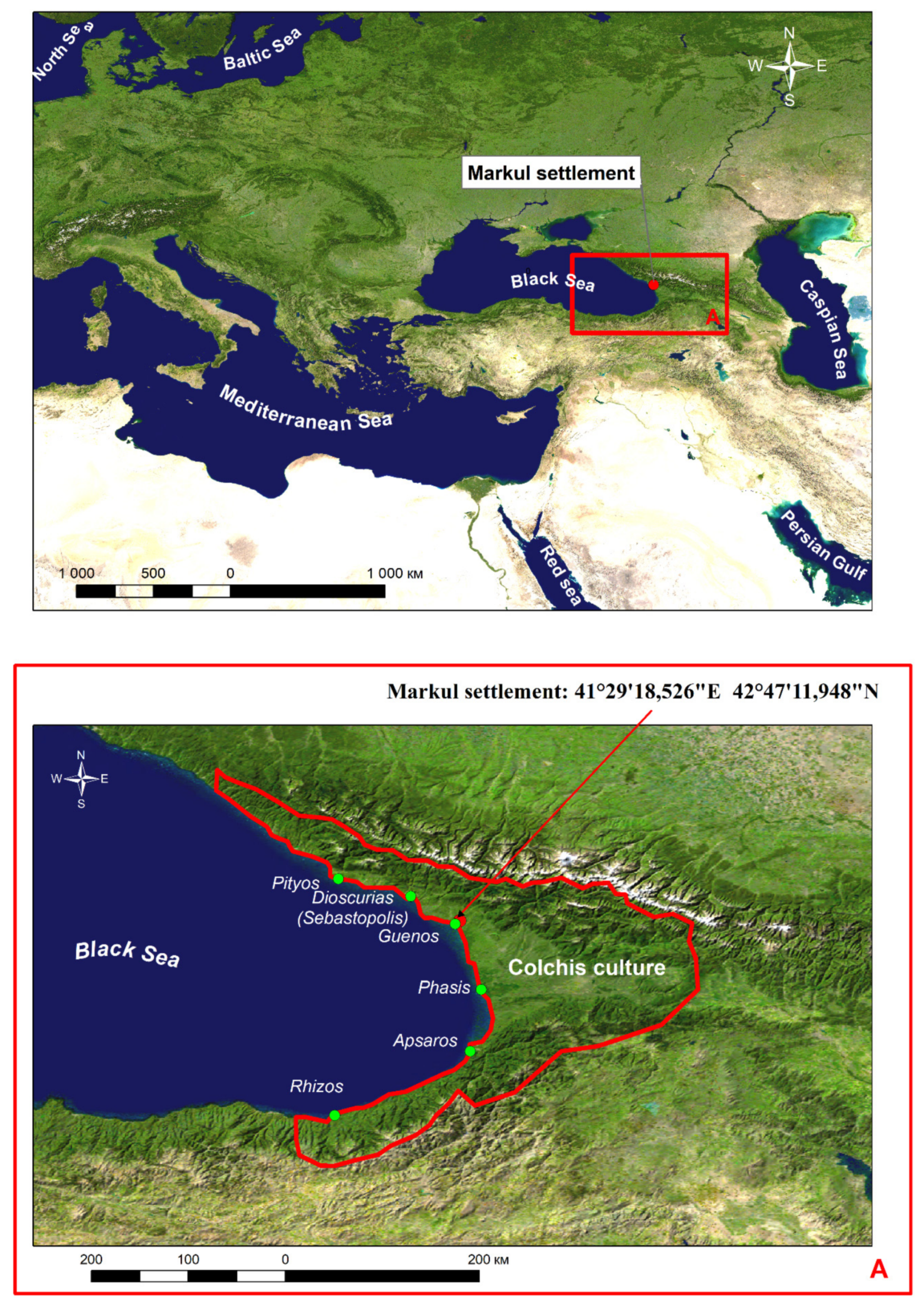
The territory of northwestern Colchis is a historical crossroads for many nations and cultures. Local tribes are known to have actively traded with both with the peoples of the North Caucasus and the states of the Mediterranean and Asia. These tribes have always been under the control of certain major powers, such as Persia, the Kingdom of Pontus, the Roman Empire, later Byzantine Empires, the Genoese Republic, the Ottoman Empire, and the Russian Empire. The tribes themselves were either truncated to several smaller state formations (e.g., Lazika, Apsilia, Abazgia, Sanigia) or united into larger states (e.g., the Kingdom of Abkhazia and Kingdom of Georgia). Despite such a turbulent history, this territory has still been under-researched by archaeologists. The Markul settlement (village of Markula, Ochamchira region, Republic of Abkhazia) was discovered by our group only in 2013. The site, fenced by the famous Kelasur wall, is located on two sufficiently high plateaus, stretching 500 m to the north, with a slope of 38 degrees east of the Black Sea coast, located 10 km inland from the ancient city of Guenos (the modern city of Ochamchira) on the left bank of the Mokva River (
Figure 1) [
1,
2].
The architectural remains comprise two tower structures, a temple, and separate fragments of walls that are still present at the site. Archaeological excavations have been carried out on the southwestern slope of the plateau. Traces of a settlement from the Hellenistic period and early Roman period have been found [
3]. The results obtained after the excavations of the temple, carried out in 2014–2017 on the plateau, have revealed that the settlement has existed from the end of the 4th century AD until the 15th century AD [
4,
5]. The findings from the excavations of both towers, performed in 2018–2020, proved that the towers existed from the 1st–3rd centuries BC up to the 15th century AD [
6] (pp. 326–328). Thus, chronologically, the existence of this site covers the period from the 4th century BC until the 15th century AD. It should be noted that, in the Hellenistic and early Roman periods, that the local people lived on an unprotected slope and in the first centuries AD they went up to the top of the plateau and built defensive structures. Nowadays, convenient access to the hill fort is located on the southwestern part of the hill. The western slopes of both plateaus have been exposed to active erosion—i.e., the part of the buildings at the top of the plateau—and, in particular, the defensive wall and part of the temple fence have already collapsed, where their remains have been found at the bottom of the hill. The eastern slope is gentler in some areas but some segments of it have collapsed. The observation of the site is constrained by the dense subtropical vegetation that covers the territory. The total area of the settlement is 2.5 hectares.
2. Materials and Methods
Traditional and modern digital methods were combined to study the settlement, in particular, using photogrammetry [
7,
8,
9,
10]. We believe that objective excavation pictures are only provided by using complex implementations of various methods and corresponding verification of the results.
A tacheometric study was carried out to obtain topographic plans for separate areas where excavations were undertaken. In order to obtain an accurate model of the landscape of the entire settlement, panorama images from a drone were used with further software processing and the output of the finished orthomodel. These works were carried out by A.A. Medvedev and T.b. Kuderina, who are employees of the Institute of Geography of the Russian Academy of Science, Department of Physical Geography and the Cartography Laboratory. The shooting was conducted using multi-rotor drones at two different altitudes, where the altitude was 50 m with the DJI Inspire 1 Pro drone (SZ DJI Technology Co., Ltd., Shenzhen, China) and 100 m with the DJI Phantom 4 Pro drone (SZ DJI Technology Co., Ltd., Shenzhen, China). Both drones were equipped with optical RGB cameras, gyro-stabilizing platforms, and global navigation satellite system (GNSS) receivers in order to obtain the exact coordinates of the central points of the images. Flight control and surveying with the drones was carried out manually so that the resulting images had an overlap along the route of at least 90% and an overlap between routes of at least 80%. The preliminary and photogrammetric processing of optical images was performed with Agisoft Metashape, (Agisoft LLC, St. Petersburg, Russia) which allows for the creation of high-quality three-dimensional models based on digital photographs via structure from motion (SfM) algorithms [
11]. The generated datasets, in the form of photogrammetric dense point clouds after the semi-automatic filtering of “high” and “low” noise areas, and the resulting orthophotomosaics were exported from Agisoft Metashape for further analysis in ArcGIS using the “3DAnalyst” and “Spatial Analyst” modules. The drone study was carried out during the winter months when the vegetation cover was minimal.
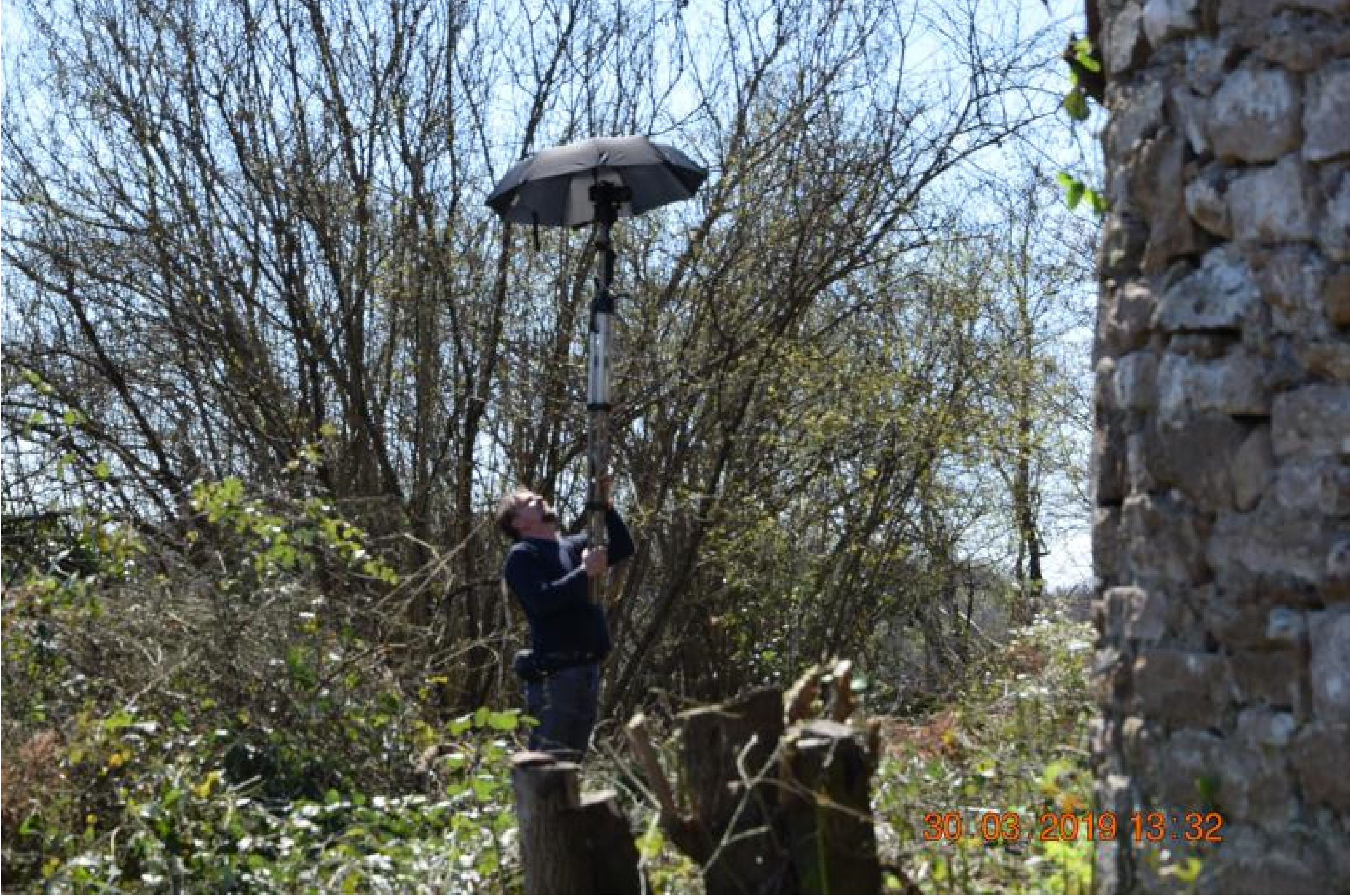
Architectural remains (towers and a temple) at the site were examined using photogrammetry methods. The photogrammetry was carried out from the ground directly by the authors of the article and a Nikon D5100 (Nikon Corporation, Tokyo, Japan) camera was used for photography. The shooting technique depended on the given height of the wall and the size of the object in focus. Usually, shooting was carried out in three rounds, with an offset of about 1 m in a circle, from eye level, with arms outstretched and shooting from a camera tripod raised to the maximum height (
Figure 2).
Thus, three survey cones were obtained with file overlaps of 60–80%. The required image resolution depends on the goals for later processing and the capabilities of the computer used for said processing. To determine the architectural features of the temple and towers and draw up plans, projections, and sections, images with resolutions of 6–8 megapixels were used here. For the temple, northern tower, and Alakhash-abaa tower, 115, 240, and 390 photos were taken, respectively. The images were processed using the Agisoft Photoscan Professional 1.1.0 (64 bit) program (Agisoft LLC, St. Petersburg, Russia).
3. Results
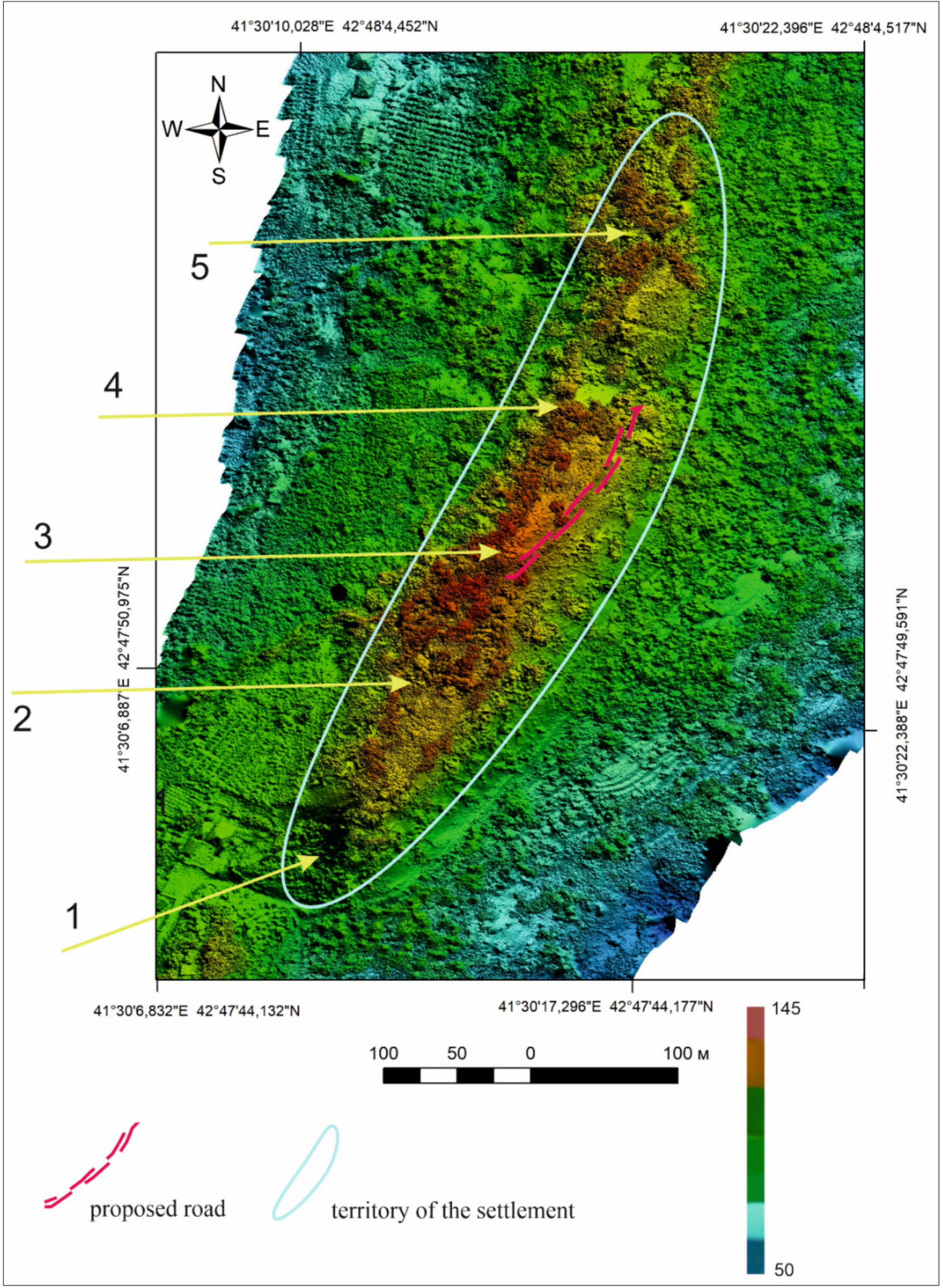
Detailed analysis of the obtained orthographic model of the settlement based on the elevation differences made it possible to determine the location of a possible road, located on the eastern side of the site along the southern plateau and up towards the temple (
Figure 3).
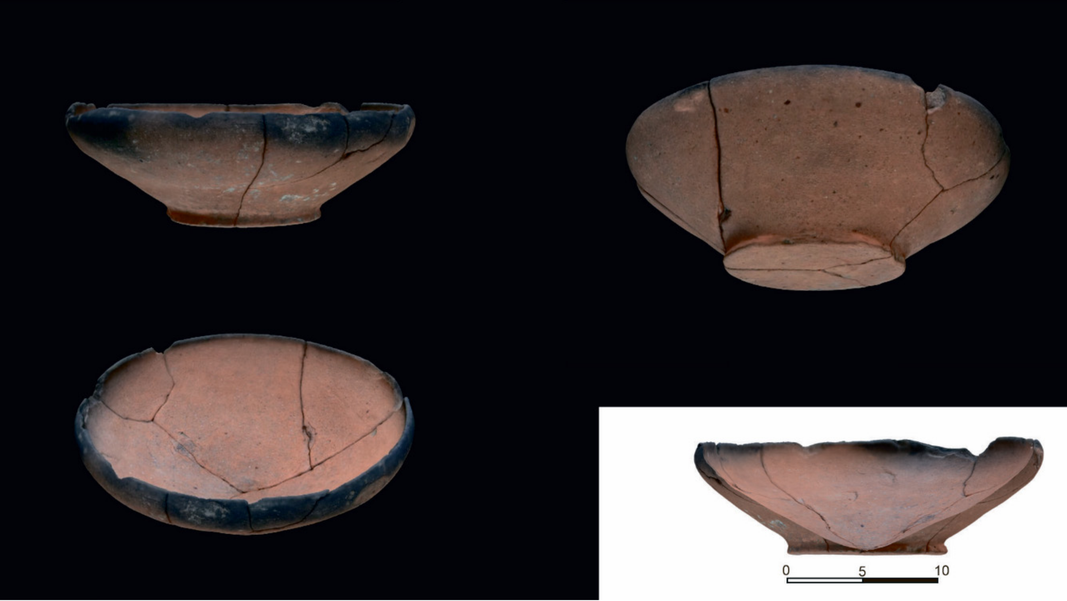
Explorations in the summer of 2020 made it possible to examine the area in more detail and confirm the possible location of the road on the site. It was determined that the road is a flat road along a rising hill on the one side and a precipice on the other, partly destroyed by abrasion. Two pits are located on the side of the road. The materials in the pits are comprised of large amounts of pottery and container ceramics from the first centuries AD. These are possibly vessels that have fallen from carts when travelling along the road towards the plateau. An unexpected finding was the handle of an Alanian camphor vessel dated between the 1st and 3rd centuries AD [
12] (pp. 68–69), [
13] (p. 79). Prior to this finding, Alanian materials have not found on the site. A uniquely preserved bowl found there was of particular interest, where analogs of the bowl have also been found among the Alans from the 1st to 3rd centuries AD as copies of Roman red-lacquered bowls [
12] (p. 71), [
13] (p. 16). The bowl itself was handed over to the Sukhumi State Museum; however, before that, a photogrammetric survey was carried out and a full 3D model was obtained for further processing of the material to support organizing virtual expositions based on the results of the work (
Figure 4). In the future, there are plans to continue studying this road.
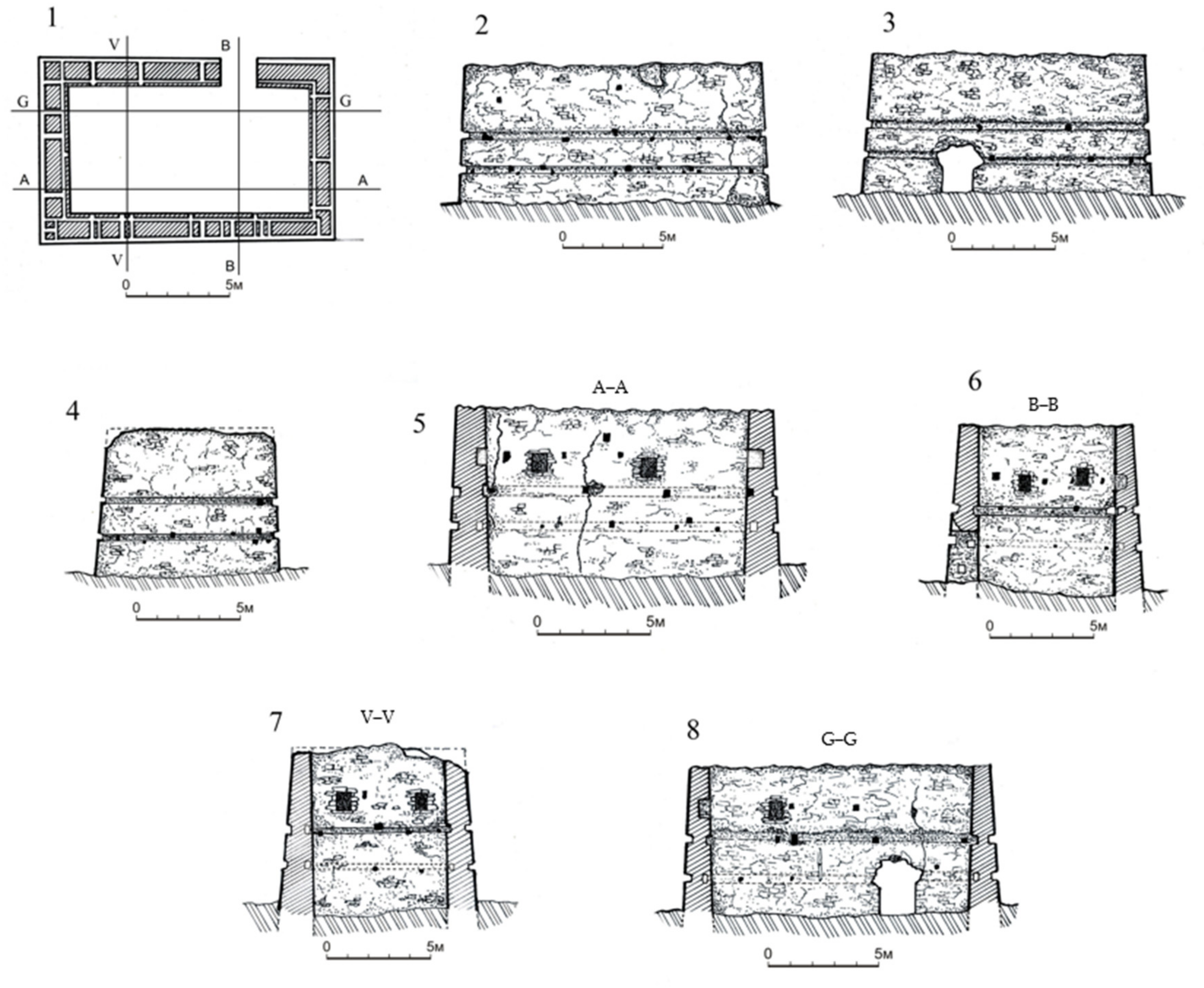
Photogrammetry was also used in the study of the architectural remains of the settlement, primarily for the southern defensive tower, referred to as “Alakhash-abaa”. The resulting orthographic model made it possible to produce the necessary architectural measurements and obtain complete drawings (
Figure 5).
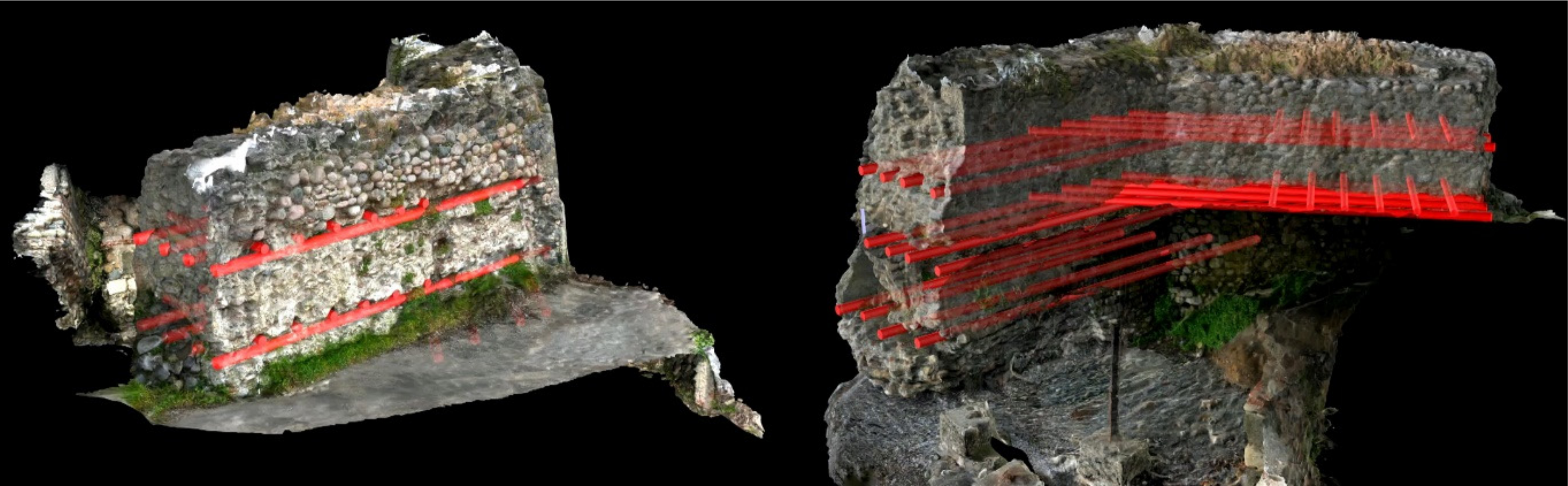
The tower is rectangular in shape, measuring 13.9 × 8.5 m, where the thicknesses of the walls in the lower part vary between 1.2 and 1.4 m, with an internal size in the lower part of 11.3 × 6.0 m. Standing 6.5–6.7 m in height, the tower has lost very little height since its construction. On the inner side of the walls, at a height of 4.0–4.5 m above the contemporary ground level, seven firing ports have been preserved, measuring between 0.7 × 0.5 m and 0.8 × 0.6 m, which are now covered from the outside (
Figure 6).
Additionally, some of the building and architectural features of the tower were identified, in particular, the specific elements of the timber longitudinal reinforcing belts of the structure. The first belt is located 1.4–1.7 m above the current ground level, and the second is 1.1–1.3 m higher above the first. Nowadays, the beam frame has not been preserved; however, according to the shapes of the remaining openings, it can be established that the beams had a 20 × 25 cm rectangular section along their entire length. The longitudinal belts of the beams were located on the outer and inner sides of the walls, oriented opposite to each other, and were tied with transverse beams after 2.5–2.8 m, the holes for which can be seen in the walls. This technique was described in detail by the Roman architect Vitruvius (Vitruvius, De Architectura I, V, 3). Additionally, such a method has been noted in the construction of the Roman fortifications of Sebastopolis (the modern city of Sukhum) [
14] (p. 300). In the medieval fortifications in northwestern Colchis, such a technique for strengthening the walls with longitudinal belts of beams has not yet been recorded. In the fortifications from the Turkish times, similar structures have been found, but featuring round beams instead of rectangular beams and they were not peeled from bark (
Figure 7) [
14] (p. 301).
It is worth mentioning the fact that, at the foundations of the earlier walls of Sebastopolis from the Byzantine period, especially in corner sections, there are parallelogram-shaped cyclopean-shaped blocks. The same kind of technique is used in some corner nodes of the base of the southern part of the tower in the Markul settlement. Excavations of the Alakhash-abaa tower in 2018 revealed the presence of several levels of floors, and in the lower layers of the tower, ceramic and glass materials from the Roman and Byzantine periods (3rd to 6th centuries AD) have been found [
6] (pp. 326–333).
4. Conclusions
As the present study has shown, aerial photography from a drone allows one to obtain high-quality images of a site at different angles at different times of the day during different seasons, and this, in turn, allows one to document the elements of a site that are invisible at first. Preliminary aerial photography from a drone enables one to obtain an exact overview and conduct explicit direct ground research. This significantly increases the efficiency of the research.
Additionally, the photogrammetry of architectural objects permits one to obtain significant data precisely after the analysis of specific architectural details. The ability to record measurements and perform detailed analysis for an architectural site in the office as opposed to the field considerably expands the capabilities of researchers.
The field research present here has fully confirmed the conclusions made in advance, including the dating of the site. The findings of Alanian origin are remarkable and they allow for further direct research into analyzing trade relationships, not only with ancient centers, but also with the tribes of the North Caucasus. The results have shown how the complex application of the methods presented here expands the capabilities of researchers, increases the accuracy of the results, and opens up new horizons for further research.
Author Contributions
Conceptualization, G.T.; investigation, G.T.; methodology, G.Y. and A.K.; supervision, G.T.; visualization, V.Y.; writing—original draft, G.T. and G.Y; writing—review and editing, K.G. All authors have read and agreed to the published version of the manuscript.
Funding
This research received no external funding
Conflicts of Interest
The authors declare no conflict of interest.
References
- Trebeleva, G. Great Abkhazian (Kelasur) wall and the problem of localization Apsilia borders. In Fortifications, Defence Systems, Structures and Features in the Past. Book of Abstracts, Proceedings of the 4th International Conference of Mediaeval Archaeology, Zagreb, Croatia, 7–9 June 2017; Institute of Archaeology: Zagreb, Croatia, 2017; pp. 39–40. [Google Scholar]
- Trebeleva, G.V. The Great Abkhazian (Kelasur) Wall: Research Results; Institute of Archaeology: Moscow, Russia, 2019; p. 397. ISBN 978-5-7114-0663-1. [Google Scholar]
- Trebeleva, G.V.; Khondziya, Z.G.; Shvedchikova, T.Y.; Yurkov, G.Y. Research on the southwestern slope of the Markul settlement. Brief. Present. Inst. Archeol. (CSIA) 2018, 252, 265–272. (In Russian) [Google Scholar] [CrossRef]
- Trebeleva, G.V.; Shvedchikova, T.Y. Burials on the territory of the Markul temple. In Procedures of the Department of Classical Archeology IA RAN; Kuznetsov, V.D., Ed.; Institute of Archaeology Russian Academy of Sciences: Moscow, Russia, 2019; Volume 1, pp. 162–173. [Google Scholar] [CrossRef]
- Trebeleva, G.V.; Sakania, S.M.; Khondziya, Z.G.; Shvedchikova, T.Y.; Yurkov, G.Y. Markul City: Discovery and researches. In V (XXI) All-Russian Archaeological Congress. Collection of Scientific Papers; IA RAN: Moscow, Russia, 2017; pp. 1038–1039. [Google Scholar]
- Trebeleva, G.V.; Khondziya, Z.G.; Yavorskaya, L.V.; Yurkov, V.G. Results of Excavations in the Alakhash-Abaa Tower of the Markul Settlement In 2018 Proceedings of the Problems of the Study of Ancient and Medieval Settlements and Burial Grounds in the Western Caucasus; Felitsyn’s Museum: Krasnodar, Russia, 2019; pp. 326–333. [Google Scholar]
- Dallas, R.W.A. Architectural and archaeological photogrammetry. In Close Range Photogrammetry and Machine Vision; Atkinson, K.B., Ed.; Whittles Publishing: Scotland, UK, 1996; pp. 283–303. [Google Scholar]
- Genin, S.M. Photogrammetry: Methods of survey and applications on restoration works. Int. Arch. Photogramm. Remote Sens. Spat. Inf. Sci. 2019, XLII-2/W11, 557–564. [Google Scholar] [CrossRef] [Green Version]
- Del Pozo, S.; Rodríguez-Gonzálvez, P.; Hernández-López, D.; Onrubia-Pintado, J.; Guerrero-Sevilla, D.; González-Aguilera, D. Novel pole photogrammetric system for low-cost documentation of archaeological sites: The case study of “Cueva Pintada”. Remote Sens. 2020, 12, 2644. [Google Scholar] [CrossRef]
- Luhmann, T.; Chizhova, M.; Gorkovchuk, D.; Hastedt, H.; Chachava, N.; Lekveishvili, N. Combination of terrestrial laserscanning, UAV and close-range photogrammetry for 3D reconstruction of complex churches in Georgia. Int. Arch. Photogramm. Remote Sens. Spat. Inf. Sci. 2019, XLII-2/W11, 753–761. [Google Scholar] [CrossRef] [Green Version]
- Medvedev, A.A.; Telnova, N.O.; Kudikov, A.V.; Alekseenko, N.A. Analysis and mapping of structural parameters of sparse Northern Taiga forests based on photogrammetric point clouds. Mod. Probl. Remote Sens. Earth Space 2020, 17, 150–163. [Google Scholar] [CrossRef]
- Gorbenko, A.A.; Kosyanenko, V.M. Necropolis of Paniardis; Azov Museum reserve: Azov, Russia, 2011; pp. 68–71. [Google Scholar]
- Abramova, M.P. Early Alans of the North Caucasus, III–V Centuries AD; IA RAN: Moscow, Russia, 1997; pp. 16–79. [Google Scholar]
- Trapsh, M.M. Ancient Sukhumi; Sukhumi: Alashara, Russia, 1969; Volume 2. [Google Scholar]
| Publisher’s Note: MDPI stays neutral with regard to jurisdictional claims in published maps and institutional affiliations. |
© 2020 by the authors. Licensee MDPI, Basel, Switzerland. This article is an open access article distributed under the terms and conditions of the Creative Commons Attribution (CC BY) license (http://creativecommons.org/licenses/by/4.0/).


