1. Introduction
Traces of human presence in Montenegro date back to the prehistoric period, which are attested in the archaeological sites of Bioče, Crvena stijena and Mališina stijena (Middle Palaeolithic), Crvena stijena, Mališina stijena, Medena stijena and Trebački krš (Upper Palaeolithic), Odmut and Vruća pećina (Mesolithic), Bijelog Polja, Doganje, Beran, and Trnje (Neolithic) [
1,
2,
3,
4,
5,
6,
7,
8,
9,
10,
11,
12,
13].
The Illyrian tribes represent the first populations that inhabited Montenegro between the fifth and the second century before Christ [
14]. After them, the territory became part of the Roman Empire, in the province of Prevalitania, and the inhabited centres of Doclea, Municipium S, Ulcinj, Budva, Risan and Meteon were formed [
15]. Over the centuries, the Roman Empire gradually declined and the Balkans were included in the Byzantine Empire, the limits of which were occupied by the Slavs in the middle of the sixth century who initiated a long process of Christianization until the tenth century. After this period, complex events affected the territory that was conquered in the centuries by Serbs, Turks, Venetians and Ottomans.
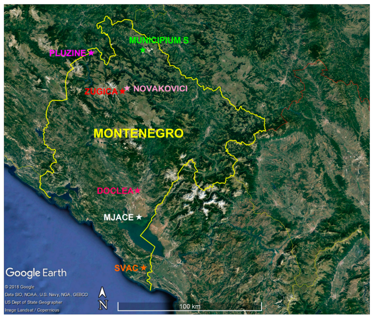
The complex history of Montenegro is reflected in a large number of movable and immovable cultural goods distributed throughout the territory, which are an invaluable source of the cultural identity of the Montenegrin population. The public institution Centre for Conservation and Archaeology of Montenegro (Centar za konzervaciju i arheologiju Crne Gore) has the central purpose of researching, protecting, and presenting archaeological findings. The archaeological division is performing different short and long-term archaeological research programs through terrestrial and underwater archaeological investigations (terrain reconnaissance, systematic archaeological excavation, archaeological survey by non-destructive methods, and other investigations) with the purpose to develop an updated archaeological map of Montenegro. These designing studies are fundamental for the protection of cultural property, the development of management plans and the marking of cultural property. In the frame of these activities, from 2016 to present, a fruitful collaboration between the Ministry of Culture of Montenegro, the Institute of Technology Applied to Cultural Heritage (now recalled Institute of Heritage Sciences, National Council of Researches of Italy) and the University of Molise led to undertake significant actions of intervention for the knowledge of the archaeological heritage. The aim was to improve and implement data regarding the hidden cultural heritage through the application of non-invasive diagnosis in the Hellenistic- Illyrian site of Mjace, the roman towns of Doclea and Municipium S, the medieval city of Svač and the Stećci medieval tombstones graveyards of Novakovići, Žugića and Plužine (inscribed on the World Heritage List in 2016) (
Figure 1). The results allowed for the successful management of them in terms of identification, protection, preservation, enhancement, fruition, and transmission to future generations.
2. Materials and Methods
The research followed a multidisciplinary approach in which geophysicists and archaeologists operated in full synergy, calibrating the procedures of intervention and taking into account all the needs of the study. The collaboration and the continuous flow of information between researchers of different disciplines guaranteed a constant exchange of ideas and results.
In a first step, for each analysed archaeological site, a detailed bibliographic and documentary collection of the edited material was realized selecting information such as archaeological data (excavation data, archaeological plans and maps), architectural data (construction techniques, reliefs, census of known architectural remains), geological data (reports relating to soil analysis, geophysical surveys, geo-archaeological investigations). All data were organized in a computerized archive, supporting and integrating the existing ones.
The planning of geophysical prospections were prepared in accordance with the archaeologists, assuming the type, size and depth of the probable findings in the subsurface and considering the logistics of the survey area and the nature of the subsoil in order to define the best strategy for the study of a particular area.
Many non-invasive geophysical methods can give useful information useful for the reconnaissance of buried structures, such as the magnetic method [
16,
17,
18], the electromagnetic induction methods [
19,
20,
21], the electrical resistivity tomography (ERT) [
22,
23,
24,
25,
26,
27], the ground penetrating radar (GPR) [
28,
29,
30,
31], the gravitational surveying [
32,
33,
34], the self-potential (SP) method, [
35,
36] and seismic methods [
37,
38].
It is not easy to define the most appropriate methodology for any archaeological problem, as different methodologies cannot give the same result considering the environmental noise of the study area, the physical properties of soils, and anthropic remains. Considering the differences in the operating principles, the instruments available for measurements, the type of responses expected, the applicability fields of the various geophysical survey techniques and the objects of the research, the ERT and GPR methods were implemented in this work.
ERT was successfully applied for archaeological investigations [
39,
40,
41,
42,
43]. The parameter on which it is based, the electrical resistivity, allows for the recognition of common archaeological structures as the presence of accumulated tiles, stonewalls, building foundations, or cavities immersed in a conductive hosting soil are usually attested to by high resistivity values.
GPR is the near surface technique that has obtained a favourable consensus among archaeologists thanks to its ability to detect a broad range of buried targets in fast way and with an optimal resolution [
28,
29,
44,
45,
46,
47,
48,
49].
Once the geophysical technique was selected, the choice of a particular instrument was decided taking into account the need of a fast survey on different soils and, in some cases, uneven terrains. For ERT prospections, the portable ELMES ADD-01 resistivity meter was used for data acquisition. It is an alternating current geoelectrical array in which two probes are used to inject a current in the range of 1 to 400 mA with a frequency selectable between 8 and 33 Hz. The potential drops are taken across a receiving dipole. For GPR surveys, the RIS K2 Georadar (IDS GeoRadar s.r.l., Pisa, Italy), equipped with a multi-frequency TRMF (time-reversal matched filter) antenna (600–200 MHz), was used for data collection.
In each case study, for both survey methods, the following features were carefully evaluated during data acquisition and processing:
The optimal setup parameters for the execution of measurements (e.g., for ERT: electrode array, electrode separation, averaging of measures, succession of measures; e.g., for GPR: antenna frequency, vertical scale definition, time zero definition, samples for radar scan, sampling frequency, time window, trace staking, stacking time).
The procedure for carrying out the survey (spacing between profiles, type of sampling, direction of transects, range of sampling, grid configuration, size of areas).
The type of standard data processing (e.g., for ERT: algorithms of inversion; e.g., for GPR: band pass filters, gain control, background removal filters, F-K filtering, deconvolution, migration, data inversion techniques). ERT data were processed using the probability-based electrical resistivity tomography inversion [
50] that, as proven in previous applications [
26,
49,
51,
52,
53,
54], is a convenient method to delineate geometrically the most probable anomalies into the ground. GPR data were processed using the IdsGred [
55] and GPR-SLICE 7.0 software [
56]. Standard methodological approaches were used: data conversion at the same time adding a gain with time; time-zero correction to designate the starting point of the wave and the center frequency of the antenna; band pass filtering to reduce noise from oscillating components that had a regular frequency cycle in the frequency domain; background removal to remove striations noises that occurred at the same time; correction with an automatic gain function applied to each trace based on the difference between the mean amplitude of the signal in the time window and the maximum amplitude of the trace.
The methods of representation of results and the type of outputs.
3. Study Areas
Seven study areas were selected for this research: the Hellenistic-Illyrian site of Mjace, the roman towns of Doclea and Municipium S, the medieval city of Svač and the Stecci medieval tombstones graveyards of Novakovići, Žugića and Plužine (
Figure 1). The choice of sites was made on the basis of a long-term archaeological research program managed by the Centre for Conservation and Archaeology of Montenegro which is providing targeted actions on archaeological sites present throughout the territory. In particular, quite heterogeneous case studies were considered taking into account their dating (from the Hellenistic-Illyrian period to the medieval period), the type of site (necropolis, cities and individual buildings), the typology of supposed remains buried underground (tombs, walls of buildings, roads, etc.) and the geological and environmental context. In every case, geophysical prospections were realized in the proximity of well-known archaeological structures identified from test trenching, or in areas with a high archaeological potential.
3.1. The Hellenistic-Hyllirian Fortification of Mjace
Mjace is located in the area of Skadar Lake (
Figure 1), a place that always provided good living conditions as attested by numerous archaeological traces discovered in the valley: the prehistoric caves of Vezačka and Dujevska; the prehistoric tumulus of Debele, Palićeva, Gornji Vukovci, Odžina glavica, Vuksan Lekići; the urban settlements of Djuteza, Ponari, Samobor, Oblun, Livari, Besac; the enstablished agglomeration of Stari Mataguži; the medieval necropolises of Šinđon, Mijela, Plavnice and Grabe; churches and monasteries as Sv. Luke, Nikoljcrkve, Sv. Petke, Trojice, Skupo, Jekse, Manastira Ćelije, Koma, Presvete Krajinske, Starčeva, Moračnika; fortifications as Lesendro, Grmožur, Tophala, Kulica and Balšinog [
57]. Considering the importance of this region with its heterogeneous content, in 2017, an archaeological survey started at Mjace (
Figure 2a and
Figure 3), in Mataguzi, taking up an excavation realized in the 1980s led to very significant results [
58]. This location reopened the search for a possible centre of the Illyrian state of Donja Zeta, built by Illyri Labeati, on toponymic and linguistic suggestions and the accuracy of data from historical sources [
59].
Although in 1961 Mjace was entered in the Register of Cultural Property as an individual site, it must be mentioned that it could be part of a unique settlement, the densely populated Starih Mataguža including locations on the route from Donjeg Gostilja to Huma, as attested to by numerous material remains from the period IV-I B.C. It should be borne in mind that such a large settlement must have had its necropolis, confirmed in Veljim Ledinama in Gostilju [
60], which, with representative and moving findings, speaks of Labeats as merchants and warriors, rather than farmers [
61].
Throughout the Illyrian period, settlements were erected on the heights and highlands, which are near and around the perimeter of the Scutari plain such as the hill forts of Oblun, Samobor, Livari, Besac, Stara Gradina, Djuteza and Medun. Mjace, which was the subject of recent research, is a fortified settlement in the plain, unique in this respect, and for now it is represented by the remains of an Illyrian-Hellenistic fortification that is made up of dry structures of blocks of larger stones (megaliths), deposited in the so-called cyclopic technique (
Figure 2b).
The base of a square tower was found, about 10 × 10 m. It was built with pieces of stone stacked and worked in an irregular way, width 1.80–2.20 m, on which seven enormous blocks of stone are preserved: four along the north eastern direction (in situ), two along the northwestern direction (in situ), and one dislocated and adjacent to the foundation area on the south eastern side of the tower foundation. The block sizes are different and range from max 1.80 × 0.95 × 0.60 to a min 0.94 × 0.76 × 0.60 m. The processing of stone squares is irregular. The external face has a more careful and faceted sculpture with well-worked joints and bearings, while the inner faces are much rougher. The Mjace fortification system is built in a planned and correct geometric conception of angles and directions. The discovery of a part of the ramparts towards west, about 120 m long and 40 m eastwards from the investigated tower, supports this statement.
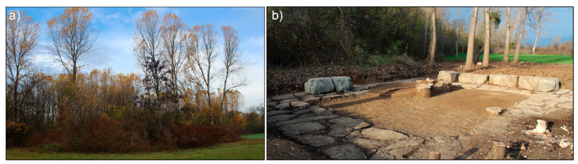
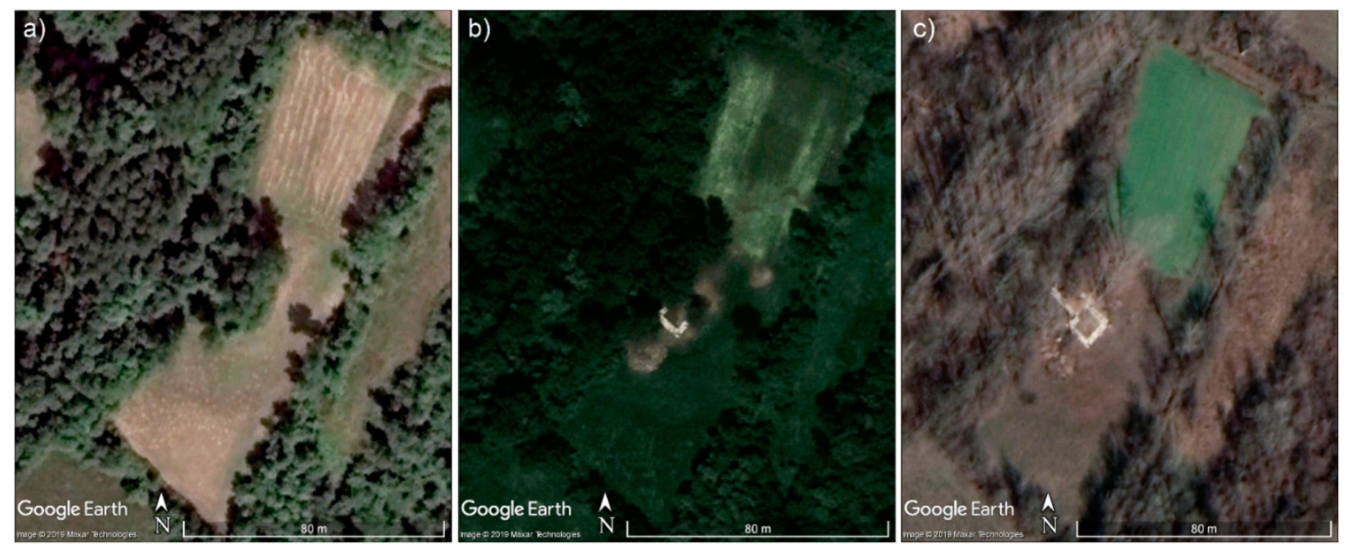
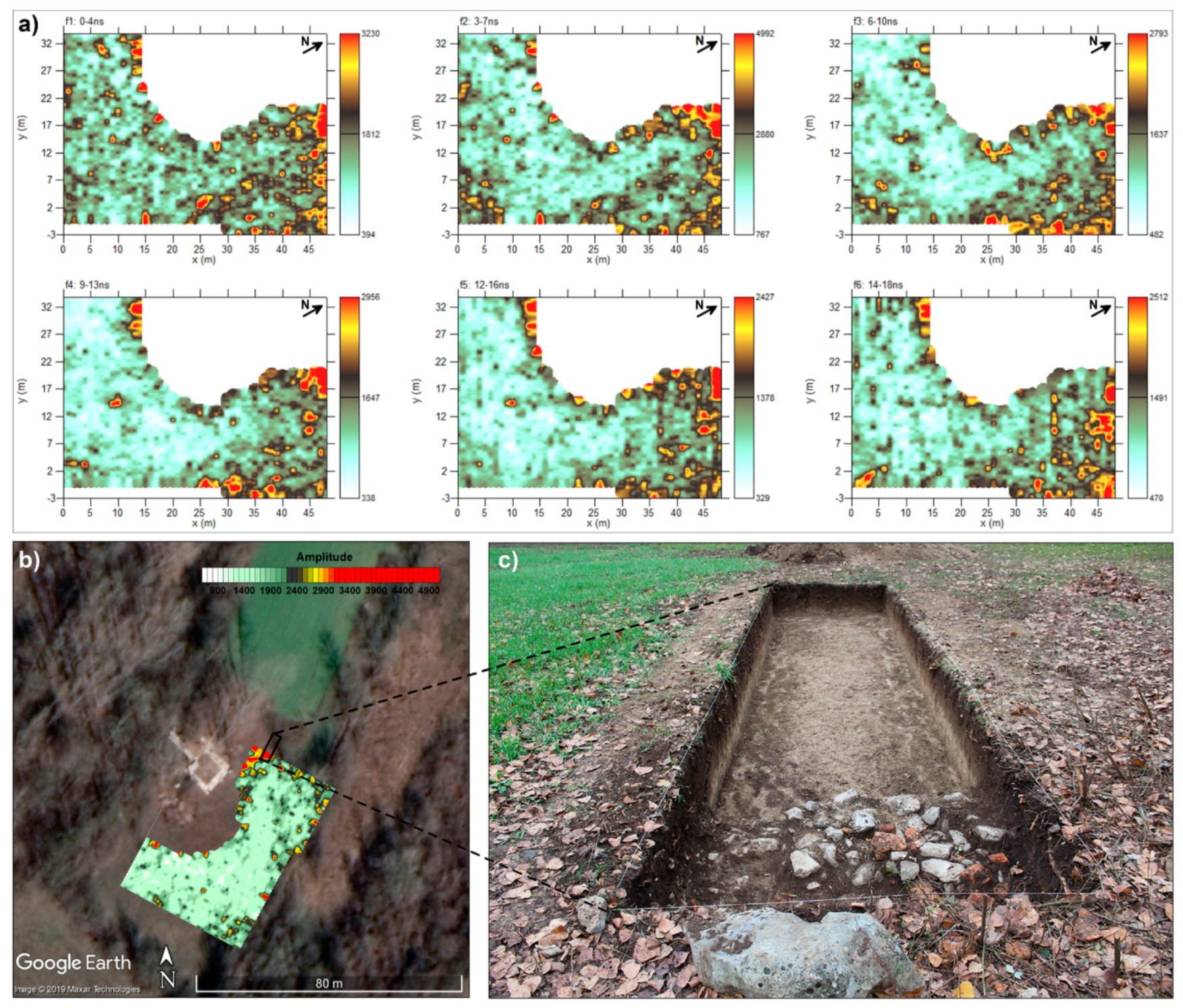
The archaeological investigation was also preceded by a geophysical survey, in accordance with the possibilities provided by the site itself, in the sense that the ground was covered by dense vegetation (
Figure 2a), in neglected and impractical conditions. In this way, the GPR investigations concerned an area in the southern and eastern parts of the tower. Ninety-six profiles, spaced 0.5 m, were acquired in direction ESE-WNW. Radar reflections on each line were recorded at 25 scan s-1 (1 scan approximately corresponds to 0.025 m) as 16-bit data and 512 samples per radar scan. The three-dimensional matrix of averaged square wave amplitudes of the return reflection was then used to extract time slices for time windows equal to 4 ns with an overlap of 1–2 ns. Data were gridded using the inverse distance algorithm, which includes a search for all data within a fixed radius of 0.75 m of the desired point to be interpolated on the grid and a smoothing factor of two. The grid cell size was set to 0.01 m to produce high-resolution images.
Figure 4a shows the most superficial time slices in the range 0–18 ns. The maps of amplitude put in evidence a situation of complete uniformity except for some high spots (with amplitudes major than 3000) with an irregular shape in the northern corner of the investigated area. The opening of a 2 × 8 m excavation test (
Figure 4b,c) by the Centre for Conservation and Archaeology of Montenegro brought to light at that point an agglomeration of small stones and broken bricks. It was interpreted as the probable superstructure of the foundation. The absence of high values for the amplitude of electromagnetic signals elsewhere, despite disappointing expectations, allowed for direct checks to be concentrated only in the points promising truly profitable results from an archaeological point of view.
3.2. The Rroman Town of Doclea
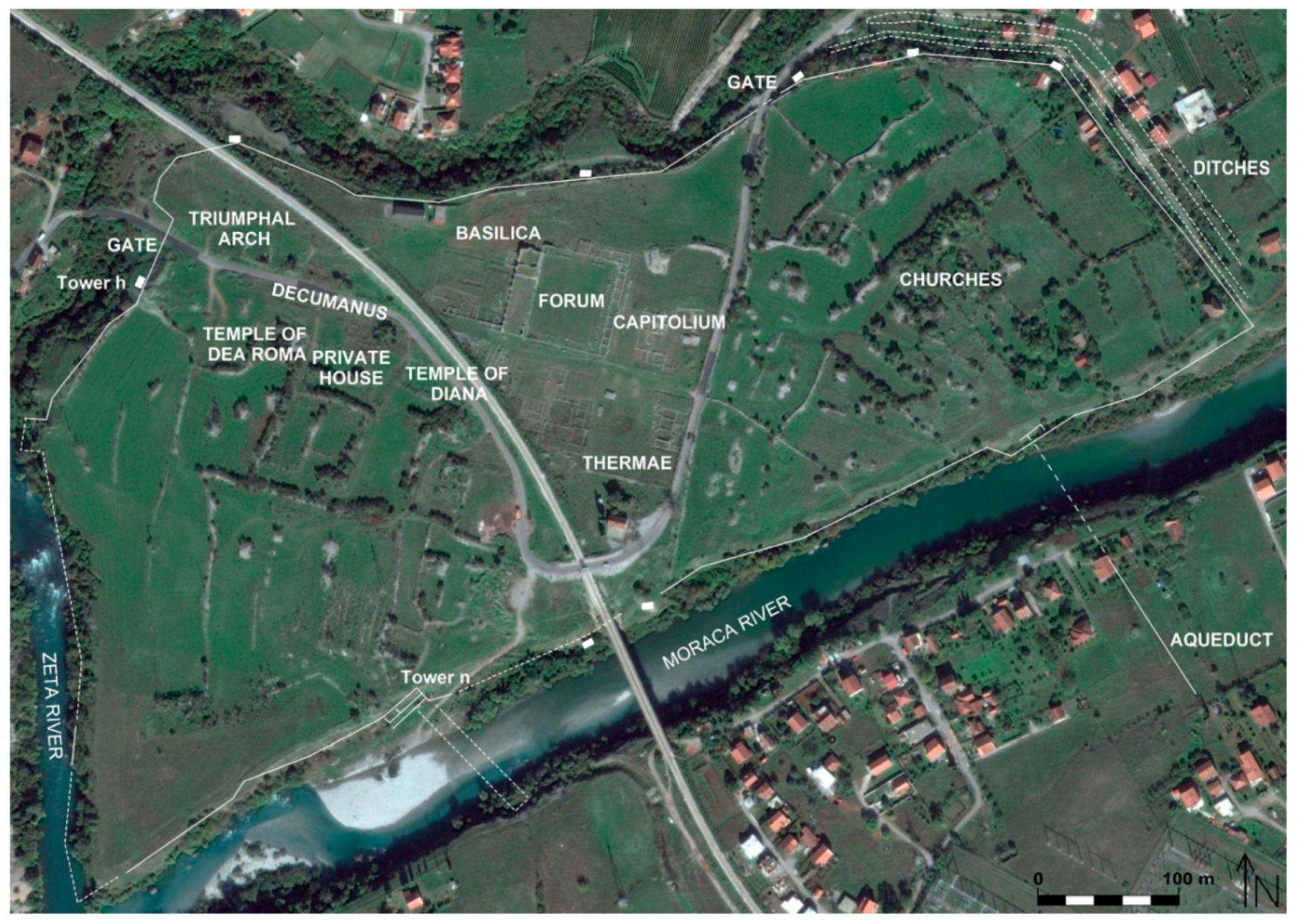
The Roman city of Doclea is located close to Podgorica, the modern capital of Montenegro, on a flat lowland where the river Zeta joins the river Morača (
Figure 5). It was an important urban centre in the Roman province of Dalmatia (I-III century A.D.) and the capital of the province of Praevalitana (II-V A.D.). It was probably abandoned during the fourth century when the Christian churches in the southern sectors were still in use. Later the city was siege of an Episcope but, until now, no trace of the late antique/early medieval town was found, with the exception of the three churches already referred to [
62]. Though naturally protected by rivers that surround the city on three sides with deep and wide riverbeds, its urban area that covers an area of 25.4 hectares was also fortified with strong walls [
63]. While the part of the perimeter that bounds the rivers was constructed with not very massive walls, the north western, northern, and north eastern parts of Doclea were fortified with vertical walls, 2.20–3.70 m wide, with rectangular towers on them.
The first archaeological excavations began between the end of the 19th century and the first twenty years of the twentieth century [
64,
65,
66]. The main buildings in the centre of the Roman city (cardo and decumanus, the thermaes, the civil basilica, the capitolium, the temples and some private houses shown in
Figure 5 and
Figure 6) as well as three medieval churches were brought to light.
Recently the Centre for Archaeological Research of Montenegro, the Museum of Podgorica and different international Universities and Centres of Research restarted research activities [
67,
68,
69,
70,
71,
72,
73,
74].
Since 2016, an extensive GPR survey was conducted at the archaeological site of Doclea [
75] partly overlapping the areas between the capitolium and the northern walls investigated in 2007 through magnetometry [
69]. A detailed comparison of results reached by the two research groups was debated in the most recent work [
75].
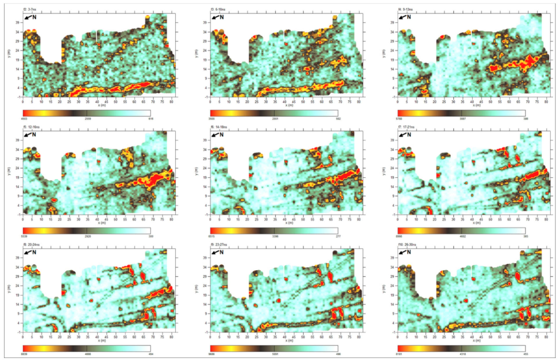
To date, an area of 32,615 m2 was investigated through 1057 profiles of variable length spaced 1 m apart. The acquisition grids were adapted from time to time to the available spaces, taking into account the presence of natural or anthropic obstacles and structures already excavated. During data processing, time slices were produced for time windows equal to 4 ns with an overlap of 1 or 2 ns.
For the sake of brevity,
Figure 7,
Figure 8 and
Figure 9 show only the sequences of three examples of slices processed at various time windows, respectively for the southern areas of the private house and the temple of Diana and the northern zone of the capitolium (1–3 in
Figure 10). The maps show a very clear regular distribution of amplitudes of the electromagnetic signal, especially in the time range 14–21 ns. Square shapes and linear traces suggest the presence of archaeological structures buried in the subsoil with a good degree of certainty.
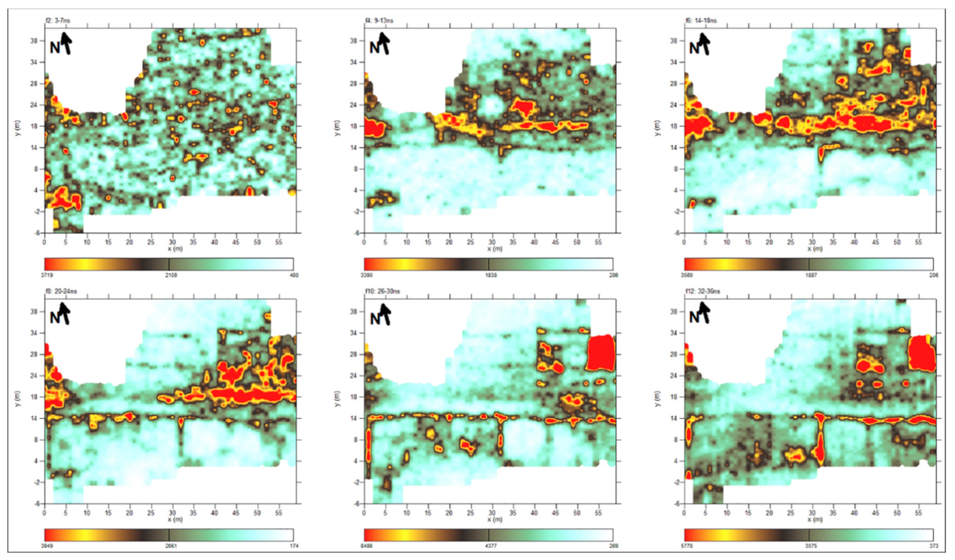
Figure 10 reports the uploaded results of investigation respect previous works [
75] with the new and unpublished data obtained in the eastern part of the thermae (A in
Figure 10) and around the medieval churches (B and C in
Figure 10). The map reports the time slice relative to the time window of 14–18 ns. Here, an interpretation of results is attempted and the plan of probable buried walls is given (
Figure 10b,c).
In general, apart from few disturbances due to the presence of modern paths, the plan highlights numerous traces of possible structures oriented according to the urban scheme known so far. The direction of the detected geophysical features is mainly WNW-ESE and NNE-SWS.
Different linear patterns of high amplitudes, parallel and perpendicular to the decumanus, can be associated with probable roads (anomalies G1–G16 in
Figure 10c). They define the division of the city into insulae (59 × 59 m) in unknown points such as between the private house and the temple of Diana, in the northern and eastern areas of the capitolium and in the eastern area of the thermae. The latter area highlighted very regular highs of amplitudes and a square anomaly is well defined.
As outlined in [
75], some irregularities in the urban scheme stand out. In particular, in the northern sector, the road curves towards the northern gate (G15 and G16 anomalies in
Figure 10c), departing from the regular pattern visible in the south (G9–G13 in
Figure 10c), and to the west of the churches, the identified pattern of streets gives a block width 75 m.
In the western area of the medieval churches, high amplitude values (in green in
Figure 10b,
Figure 11) are sparser and their distribution changes direction in the space (NNW-SES, WSW-ENE) with respect to the other areas. This may prove that, near the limits of the wall circuit and far from the public area, the concentration of buildings could have been lower. In 2018, an excavation proved the existence of a wall dated to the second century in the exact location expected by the geophysical investigation (
Figure 11).
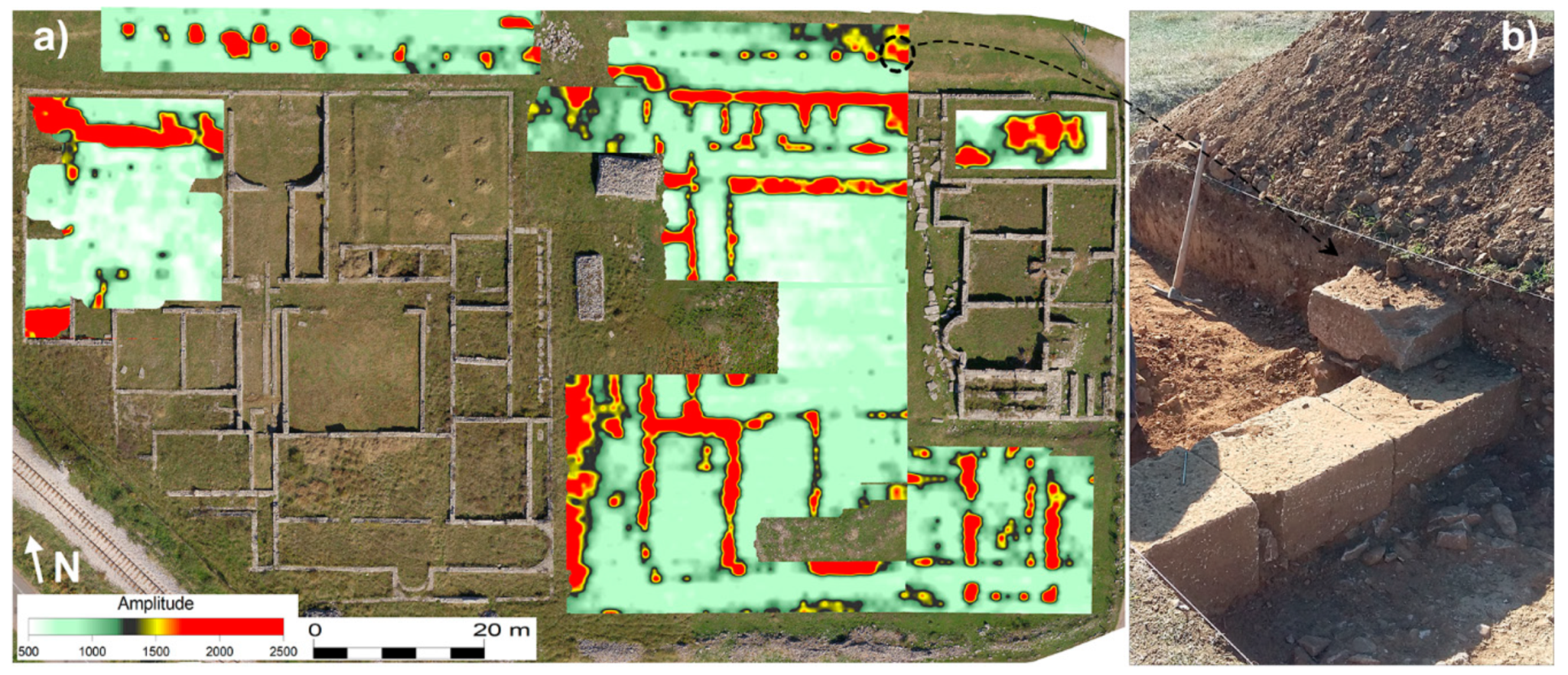
Particularly noteworthy are the results obtained near the thermae where several rooms of the building, an open central space (a probable courtyard) and some hypothetical column bases on the southern border of the decumanus are clearly recognizable (
Figure 12a). In 2019, the Centre for Conservation and Archaeology of Montenegro conduced an excavation orthogonal to the decumanus. The test proved the presence of a base of column in correspondence of the eastern high amplitude spot laying on the southern border of the road (
Figure 12b).
Works are still proceeding with the aim to produce a full map of the hidden structures inside the walls of the city. This research can be useful as well as to reach a complete knowledge of the site also for the protection and the development of management plans of the archaeological area.
3.3. The Roman Town of Municipium S
Municipium S is, in addition to Risinium and Doclea, one of the most important urban centres of Roman age in the southeast part of the province of Dalmatia. The name of this ancient place is unknown. It is believed that the abbreviation “S” in an inscription refers to the name of the municipium, although any other inscription does not prove it. The Roman city existed from the 1st to the 4th centuries A.D. which the findings from epigraphic monuments attest to.
In two areas of necropolis, about 700 burials with stone grave stelae, many of which bear inscriptions, were excavated. The tombs, mentioned by Arthur Evans in the mid-1800s [
76], were studied between 1964 and 1975 by the University of Belgrade [
77,
78,
79,
80]. The discovery of a large quantity of pottery probably produced locally has led to the hypothesis of the existence of a ceramic workshop in Municipium S as testified by the discovery of mortars and bricks [
81]. The most valuable finding is a glass vase, a rare example of diatretum, locked in a decorative cage produced by an important Cologne workshop and dated to the fourth century A.D.
There is no information, however, on the public, administrative and residential centre of the Roman city. The size and the urban conception, the location of its ramparts, gates and routes of access roads are a great concern to this day, since only a small urban area was covered by archaeological research so far in 2007 and 2008. Two large residential complexes in a rather peripheral area of the city came to light, one with a hypocaust (1 and 2 in
Figure 13). In the same area, an apsidal building has emerged which houses three altars with inscriptions (3 in
Figure 13). The excavation of this building is still ongoing by the Centre for Conservation and Archaeology of Montenegro. All these were the reasons to enter the project with the intention of wider prospecting and defining the spatial boundaries of this significant ancient site.
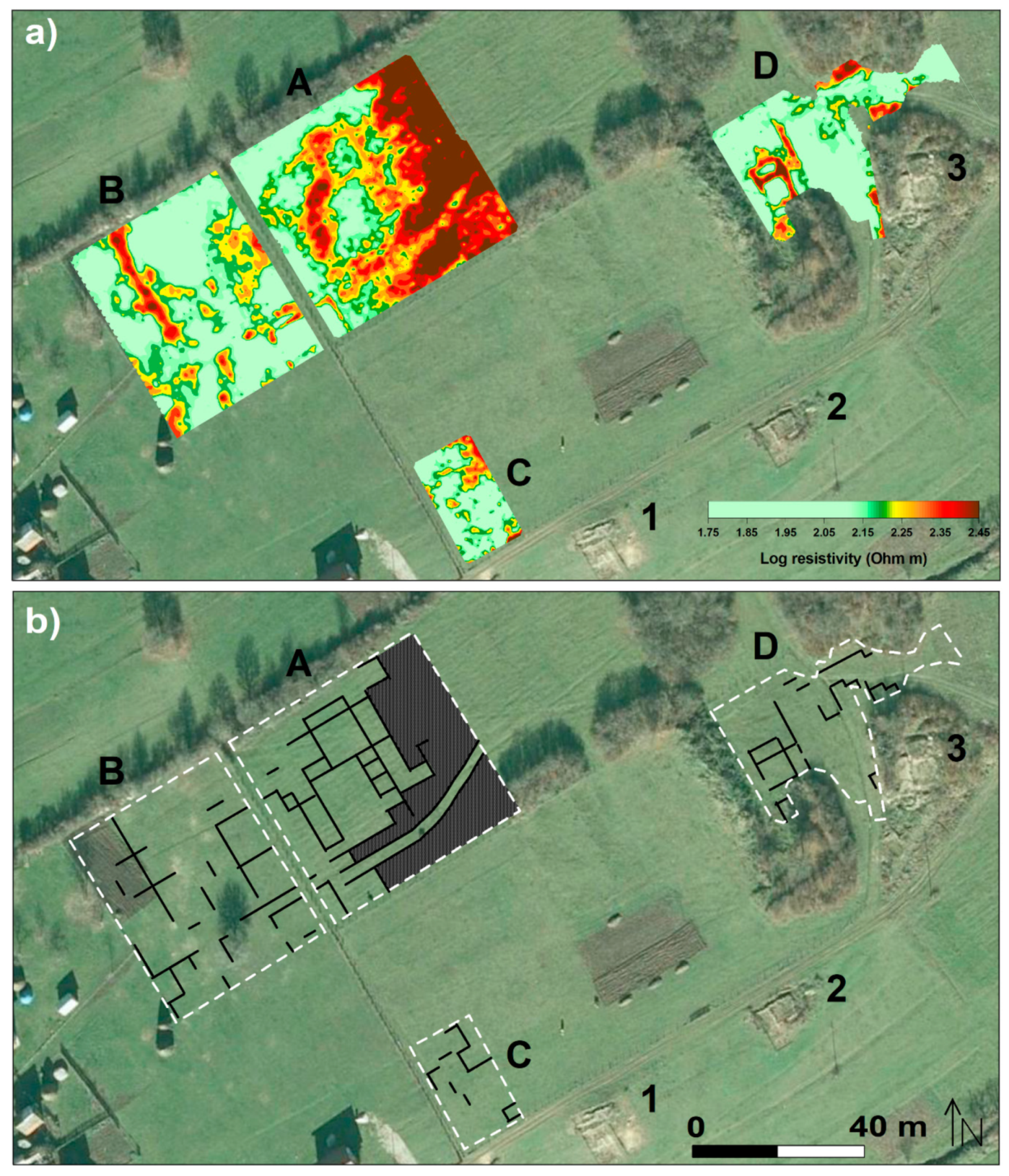
In order to defining the spatial boundaries of the city, in addition to archaeological excavation, geophysical surveys were conducted using the ERT survey in four areas (A–D in
Figure 13).
During data acquisition, an axial dipole-dipole array was implemented with the two dipoles, 1 m long, placed at a step of 1 m along each profile acquiring apparent resistivity data at a pseudo depth of 1 m. In any case, lines were equally spaced at 1 m in the grids.
Areas A and B were surveyed implementing respectively 53 and 42 parallel profiles, 56 m long, and about 4400 data were acquired in the NNW-SES direction. Area C was surveyed through 18 profiles, 33 m long, collecting a data set of 560 apparent resistivity values while Area D was analyzed implementing profiles with different lengths and about 1200 data were measured.
The imaged resistivity map relative to 1 m in depth puts in evidence different regular pattern of resistivity highs that can be attributed to buried archaeological findings (
Figure 13). Areas A, B, and C highlight a complex system of structures of which are shown in same cases the internal divisions. They appear to be aligned to the few element extracted by previous archaeological digging (1 and 2 in
Figure 13).
Results in Area D, very close to the essay in progress, shows the individuation of the closing wall of the building in the northern sector and, above all, the discrimination of a new edifice in the western side of the investigated area about 10 long and 7 m wide (
Figure 14). Two rooms of it are precisely drawn by the distribution of high values of resistivity.
3.4. The Roman Town of Svač
The medieval town of Svač is located 20 km northeast of Ulcinj, on one of the reefs of Šasko Hill. According to a legend, Svač owned as many churches as the number of days in a year, however today many of them are in ruins and only eight have survived. The city was organized in the upper town, the suburbs and the southern part according to the spatial disposition (
Figure 15). Remaining buildings are in very bad state: cracked, demolished, and overgrown with plants (
Figure 16) [
82].
The settlement started to form in prehistory but according to visible remains of public, private and sacral buildings, the biggest part of the town belong to medieval period. It was mentioned for the first time as an episcopal place in 763 and in 1089 when it was enlisted under Bar Archbishopric [
83,
84,
85]. In 1242, Mongolians demolished it and, in the second half of the eighteenth century, Queen Jelena Anzujska restored the devastated town [
82]. It began to deteriorate far long before the arrival of the Turks in 1571 [
82].
An archaeological excavation carried out during 2012 led to the identification of a large structure of dimensions 40 × 32 × 45 m, a probable palisade wall that covers a post monastery cemetery [
82]. On the north part, the structure is about 7 m narrower, which gives impression that it has a mild trapezoidal shape (4 in
Figure 15).
In order to add elements to understand the structure, 73 parallel electrical resistivity profiles were measured with an electrode spacing equal to 1 m inside the partially excavated building. About 3000 apparent resistivity values were acquired at a pseudo depth of 1 m.
A high-resolution orthomosaic was used as base on which overlap geophysical results. 195 images acquired by drone were automatically oriented in a state-of-the-art structure from motion (SfM) software application (Agisoft Metashape) [
86,
87].
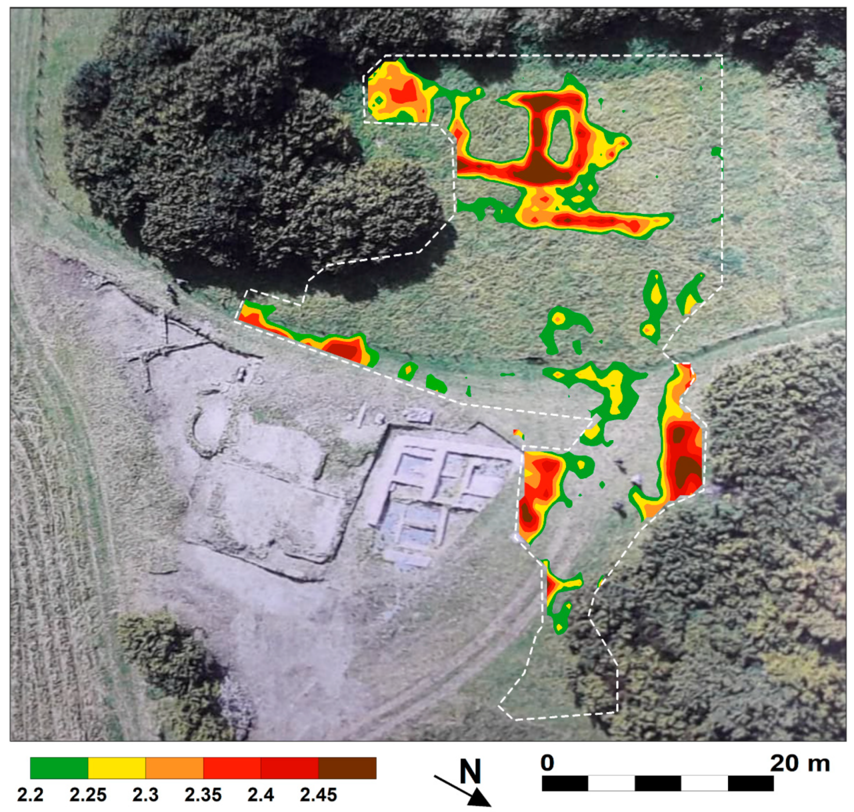
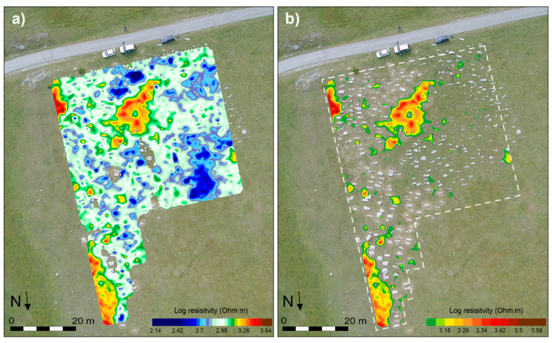
Figure 17 shows the imaged resistivity maps relative to 1 m in depth for the surveyed area. In
Figure 17a, a graphical representation was realized using a colour scale according to which the subsoil zones with lower resistivity are displayed through the shades of blue, on the contrary with shades of red the areas with greater resistivity are represented. The existence of conductive areas, as in the central and northern part of the structure, depicts a non-vanishing probability to find ancient remains as it could potentially represent depressions and anthropic cavities filled with sediment or traces of burial pits. In
Figure 17b, low resistivity values were coloured with a uniformed green shade in order to put in evidence resistive targets that can be attributable to potential remains of built structures. The main features are signed using dot lines.
Resistivity highs (A) were individuated in the eastern part of the known archaeological structure and their distribution is perpendicular to its main wall (wall 1). The resistive alignment is 23 m long (since its end was not detected, it probably develops further outside the investigated area) and 4 m wide.
The resistive feature B, partially detected, is 4 m large and it is perpendicular to the alignment A. Two low resistivity areas (C and D) are present between the regular patterns A and B and they could represent empty spaces.
The resistive alignment E flanks wall 1 and it is perpendicular to A. To the south and east of E and A, several consistent patterns of resistivity highs form right angles between them. Some of them include the resistivity lows F.
The aligned high resistivity values G have a clearly square shape with the north-south side about 6 m long. They are divided by the presence of wall 1 in the centre.
Resistivity highs (H) lie in the corner between wall 1 and wall 2. The resistivity features I are parallel to A and perpendicular to the wall 1. The resistivity lows J are flanked on three sides by regular anomalies. Resistivity highs K and L represent the probable continuation of the partially small walls perpendicular to wall 3. The same situation is found to the west of wall 3 (N). Resistivity highs M are perpendicular to wall 3.
Given the regularity of the detected features, it is plausible to hypothesize that they correspond to sections of walls still buried into the soil. Some anomalies seem to form small rooms.
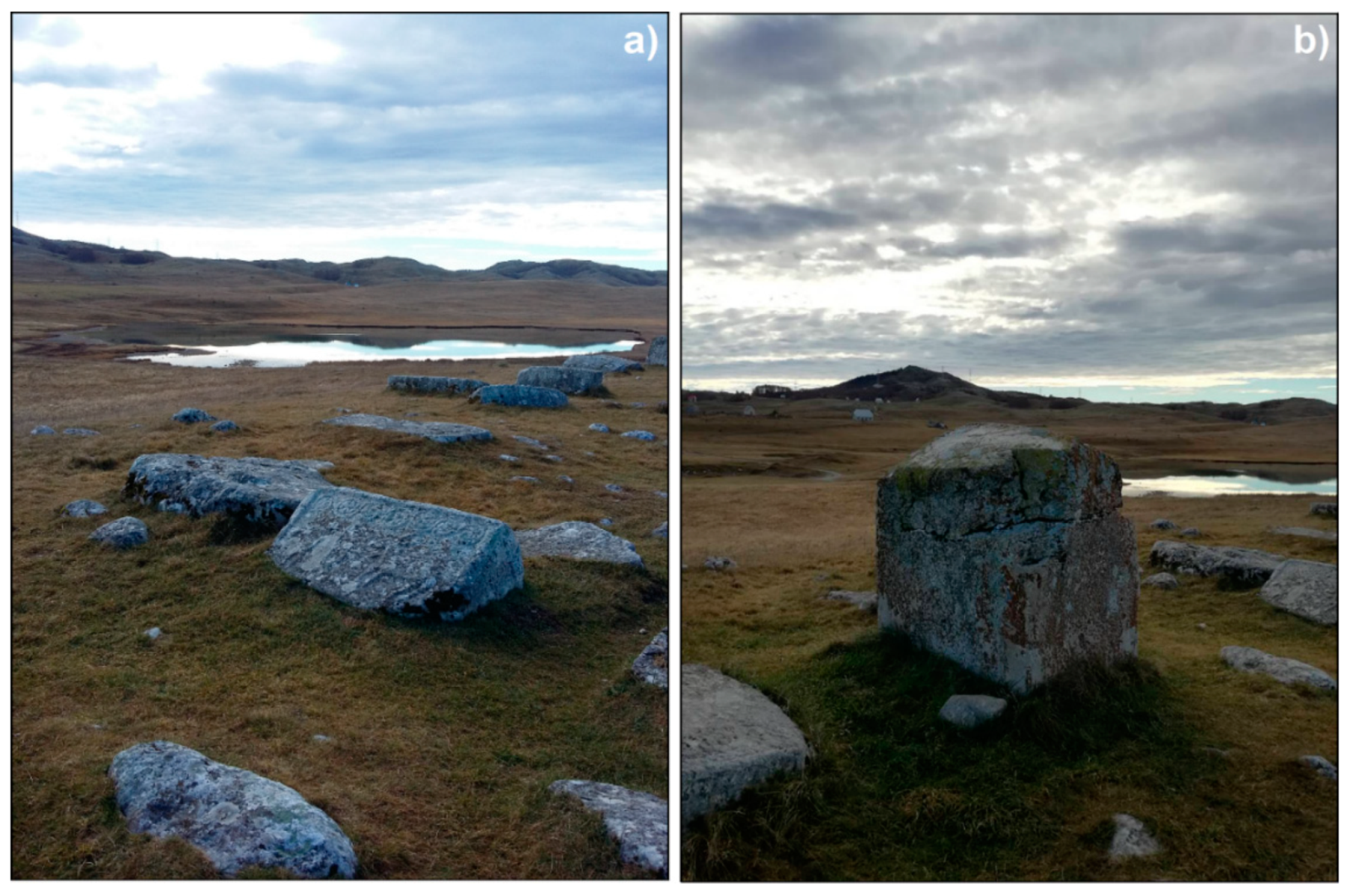
3.5. Stećci of Novakovići, Žugića and Plužine
Stećci are monumental medieval monolithic tombstones that are exclusive testimony of the culture of Bosnia and Herzegovina, Serbia, Croatia and Montenegro. Their location is limited to the territory included between the Sava River (north), the Adriatic coast (south), Lika in Croatia (west) and Serbia (east). Recognizing their outstanding universal value, a selection of 4000 tombs at 28 sites was inscribed on the UNESCO World Heritage List on 15 July 2016 [
88]. Stećci first appeared in the second half of the twelfth century and they were realized until the sixteenth century.
There are three necropolises in Montenegro: Novakovići and Žugića in the Durmitor National Park, and Plužine in the hamlet of Zagrađe in the northwest part of the country.
The necropolis of Plužine is represented by stećci that belong to the type of chests or slabs and they are mostly undecorated. The biggest tombstone (
Figure 18a) contains an inscription that is particularly important in terms of historic data because it mentions kristijanin (Christian) Petko, who lived in the town of Soko during the time of the Duke Stjepan Kosača in the early fourteenth century.
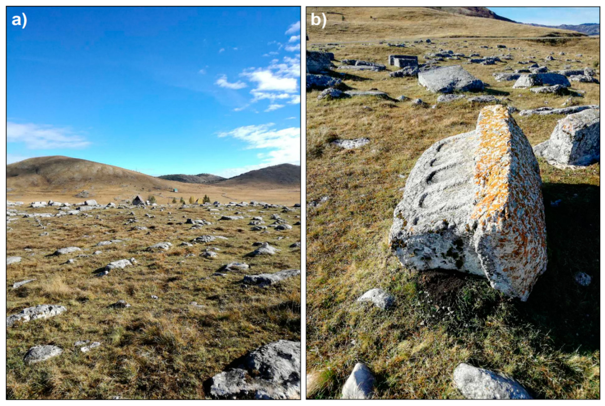
Stećci of Novakovići are located on the top of a hill and extends on a surface of about 500 m
2 (
Figure 19a). The 49 tombs are east west oriented and 22 of them are decorated with arcades, twisted bands, friezes, frames, edgings with parallel slanting tiny lines, twining vines with spirals, trefoils, garlands, or palmettes (
Figure 19b).
Stećci of Žugića (
Figure 20) is situated around 2230 m to the northeast of the Stećci of Novakovići. 300 stećci are regularly organized in east-west rows and the most fine decorated are located in the middle of the necropolis. The tombstones belong to different typologies: slabs (10), chests (50), gabled roof tombstones (10) and amorphous blocks (230). Further, 23 of them are decorated with motifs such as bands, frames and edgings with slanting tiny lines, plain and twisted bands, plain and stylized crosses and bows with arrows. There are few cases of arcades, twining vines with trefoils, concentric circles connected with a ribbon, rosettes, crescents, swords, and shields.
The necropolises with stećci have not been subject to archaeological excavations and investigation and recently they are going to be treated by applying conservation and restoration procedures.
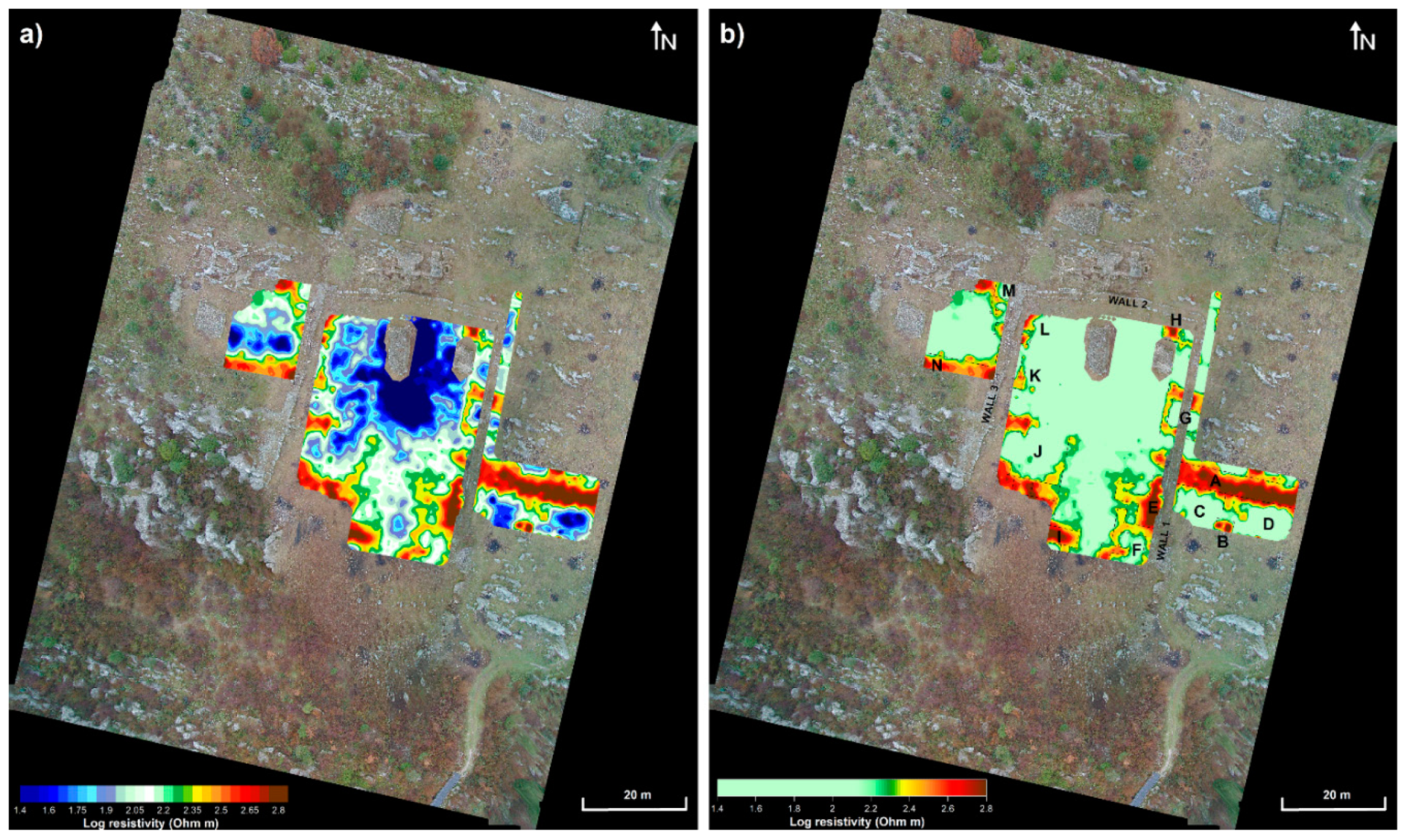
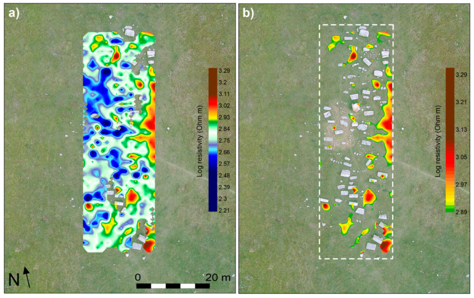
Electrical resistivity surveys were realized with the aim to understand the presence of tombs still buried into the subsoil enhancing the knowledge of the necropolis. At Plužine, 12 profiles were acquired collecting about 350 apparent resistivity values. At Novakovići, the survey employed 16 profiles reaching a data set of 670 apparent resistivity values. At Žugića, 60 lines were investigated and 2700 data point were collected. In any case, lines were equally spaced at 1 m in the grids.
Figure 21,
Figure 22 and
Figure 23 show the modelled resistivity maps relative to 1 m in depth for the three archaeological sites. At the left of the
Figure 21 and
Figure 22, the graphical representations were realized using a colour scale according to which the subsoil zones with lower resistivity are visualized through the shades of blue, while in contrast to more resistive zones correspond to colours with gradations towards red. At the right of the figures, low resistivity values were made transparent in order to better highlight the highly resistive values. The resistive nuclei could be ascribed to probable tombs buried into the subsoil and they are all located in spaces devoid of visible burials on the surface.
Figure 23 shows the resistivity map at the necropolis of Plužine where the nuclei that could be ascribed to probable tombs are signed with black crosses.
4. Conclusions
The study has shown the results of the application of non-destructive geophysical prospections in different archaeological contests, each one with peculiar features considering the nature of the soil, the logistic of the area, the type and size of the probable findings in the subsurface (walls, tombs, road, structures, etc.). The selected case studies were variable also considering the age they belong that varies from the Hellenistic- Illyrian period to the Medieval Age.
In any case, a good knowledge of archaeological sites was reached that was useful for the planning of archaeological excavations or for the preventive safeguard projects.
As regards the site of Mjace, the GPR survey allowed to border the extension of the cyclopean construction targeting in a precise way the archaeological verifications that proved the presence of the superstructure of foundation of the tower in correspondence of highs of amplitude of electromagnetic signals. Elsewhere, the negative result, namely the absence of anomalies, must be interpreted in any way as important data with respect to knowledge of the site, restricting future direct investigations to more profitable points.
The extensive GPR survey at the roman city of Doclea provided valuable results highlighting numerous traces of possible structures oriented according to the urban scheme known so far. In particular, new buried buildings were in some cases perfectly drawn, the viability and the division in insulae were clarified, and anomalies in the regular layout of the city were detected in the southern part of the northern walls and around the medieval churches. The comparison between the hypothesized buried features through geophysical data and the excavated structures in two trenches has demonstrated the perfect correspondence between the expected result and the real found ancient elements. Such a large-scale map of the archaeological site represents a great advantage in terms of conservation and enhancement of it, since all the necessary elements are provided to prepare interventions that avoid or minimize the impact with areas of high archaeological potential. Furthermore, not involving intensive mechanical work, such research did not endanger the structures that were intended to localize and minimized the use of expensive and laborious, as well as intrusive, methods such as drilling and digging trenches, albeit with a higher cognitive degree.
The Municipium S site still reserves many doubts about the public, administrative and residential centre of the roman city as few and fragmented studies are available today. The ERT survey provided details which, although limited to restricted areas, confirm the great potential resource of the archaeological area, with useful data for planning future excavations and better understanding the little-known site. In terms of preventive conservation, these results represent the basis for undertaking protective restrictions in the processing and alteration of soils.
The survey at the archaeological site of Svač provide useful results regarding the internal division of the analysed structure, providing a detailed location of the most probable buried walls. Future archaeological verifications may be planned in detail for points where direct investigation could be advantageous and profitable.
The necropolises with Stećci of Novakovići, Žugića, and Plužine have not been subject to archaeological excavations and investigation until now. The geophysical prospections at the sites provided the position of new unknown probable tombs into the soil. This information, applied to conservation and restoration procedures, can be useful for future research activities. In general, this study offered an enrichment of the knowledge of the studied areas and supplied an updated view of the rich archaeological heritage of Montenegro.
Author Contributions
Conceptualization, M.C. and P.M. (Paolo Mauriello); Data curation, M.C., M.B., N.B., V.G., M.J., P.M. (Paolo Mauriello) and M.Ž.; Investigation, M.C., M.B., N.B., G.G., V.G., M.J., P.M. (Pasquale Merola) and M.Ž.; Methodology, M.C. and P.M. (Paolo Mauriello); Project administration, M.C. and P.M. (Paolo Mauriello); Supervision, M.C. and P.M. (Paolo Mauriello); Writing–original draft, M.C.; Writing–review & editing, M.C. All authors have read and agreed to the published version of the manuscript.
Funding
This research received no external funding.
Acknowledgments
The research was realized in the frame of a Memorandum of Understanding between the ex Institute of Technology Applied to Cultural Heritage (ITABC, now Institute of Heritage Sciences, CNR, Italy) and the Ministry of Culture of Montenegro (2016–2021). The Centre for Conservation and Archaeology of Montenegro carried out archaeological researches. As regards the site of Doclea, part of the activities were in the frame of a Joint Archaeological Laboratory between the Institute for Ancient Mediterranean Studies (ISMA, now Institute of Heritage Sciences, ISPC-CNR, Italy) and the Historical Institute of Montenegro (HIM) (2017–2018), with the collaboration of ITABC, and in the frame of the Project of Great Relevance of the Ministry of Foreign Affairs and International Cooperation between the Department of Social Sciences, Cultural Heritage of CNR and HIM (2018–2020), both coordinated by Lucia Alberti and Tatjana Koprivica. University of Molise took part in all the phases of the projects.
Conflicts of Interest
The authors declare no conflict of interest.
References
- Garašanin, M. Crna Gora u Praistorijsko Doba; Redakcija za istoriju Crne Gor: Titograd, Montenegro, 1967.
- Batović, Š. Jadranska zona. PJZ 1979, 2, 473–634. [Google Scholar]
- Kozlowski, J.K.; Kozlowski, S.K.; Radovanovic, I. Meso—And Neolithic Sequences of the Odmut Cave Montenegro; University of Warsaw: Warsaw, Poland, 1994. [Google Scholar]
- Marković, Č.; Srejović, D. Neolit Crne Gore; Univerzitet u Beogradu, Filozofski fakultet, Centrar za archeološka istraživanjia: Beograd, Serbia, 1985. [Google Scholar]
- Zvelebil, M. The agricultural transition and the origins of Neolithic society in Europe. Doc. Praeh. 2001, 28, 1–26. [Google Scholar] [CrossRef]
- Richards, M. The Neolithic transition in Europe: Archaeological models and genetic evidence. Doc. Praeh. 2003, 30, 159–167. [Google Scholar] [CrossRef] [Green Version]
- Bogićević, K.; Dimitrijević, V. Quaternary Fauna from Mališina stijena near Pljevlja (Montenegro). Zb. Rad. Odbora za kras i Speleol. 2004, 8, 119–133. [Google Scholar]
- Forenbaher, S.; Kaiser, T. Palagruža i širenje zemljoradnje na Jadranu. Opvsc. Archaeol. 2005, 29, 7–23. [Google Scholar]
- Đuričić, L.J. A contribution to research on Bioče Mousterian. J. Serb. Archaeol. Soc. 2006, 22, 179–196. [Google Scholar]
- Marković, Č. Arheologija Crne Gore; Biblioteka Crna Gora: Podgorica, Montenegro, 2006. [Google Scholar]
- Mihailović, D. Social aspect of transition to farmind in the Balkans. Doc. Praeh. 2007, 34, 73–88. [Google Scholar] [CrossRef]
- Mihailović, D. Upper Palaeolithic and Mesolithic Chipped Stone Industries from Crvena Stijena; University of Belgrade, Faculty of Philosophy, Centre for Archaeological Research: Belgrade, Serbia, 2009. [Google Scholar]
- Borovinić, N. Arheološko istraživanje neolitskog naselja u selu Doganje, Opština Pljevlja. In Godišnjak; JU Centar za konzervaciju i archeologiju Crne Gore: Cetinje, Montenegro, 2018; Volume 1, pp. 1–19. [Google Scholar]
- Stipcevic, A. The Illyrians. History and Culture; Noyes Press: Park Ridge, NJ, USA, 1977. [Google Scholar]
- Smith, W. Dictionary of Greek and Roman Geography; Little, Brown & Co.: Boston, MA, USA, 1854. [Google Scholar]
- Aitken, M.J. Physics and Archaeology, 2nd ed.; Clarendon Press: Oxford, UK, 1974. [Google Scholar]
- Weymouth, J.W. Geophysical methods of archaeological site surveying. J. Archaeol. Method Theory 1986, 9, 311–395. [Google Scholar]
- Gibson, T.H. Magnetic prospection on prehistoric sites in western Canada. Geophysics 1986, 51, 553–560. [Google Scholar] [CrossRef]
- Bevan, B.W. Electromagnetics for mapping buried earth features. J. Field Archaeol. 2013, 10, 47–54. [Google Scholar]
- Scollar, I. Electromagnetic Prospecting Methods in Archaeology. Archaeometry 1962, 5, 146–153. [Google Scholar] [CrossRef]
- Tabbagh, A. Applications and Advantages of the Slingram Electromagnetic Method for Archaeological Prospecting. Geophysics 1986, 51, 576–584. [Google Scholar] [CrossRef]
- Cammarano, F.; Mauriello, P.; Patella, D.; Piro, S.; Rosso, F.; Versino, L. Integration of high resolution geophysical methods. Detection of shallow depth bodies of archaeological interest. Ann. Geofis. 1998, 41, 359–368. [Google Scholar]
- Mauriello, P.; Monna, D.; Patella, D. 3D geoelectrical tomography and archaeological applications. Geophys. Prospect. 1998, 46, 543–570. [Google Scholar] [CrossRef]
- Compare, V.; Cozzolino, M.; Mauriello, P.; Patella, D. 3D Resistivity probability tomography at the prehistoric site of Grotta Reali (Molise, Italy). Archaeol. Prospect. 2009, 16, 53–63. [Google Scholar] [CrossRef]
- Compare, V.; Cozzolino, M.; Mauriello, P.; Patella, D. Resistivity probability tomography at the Castle of Zena (Italy). Eurasip J. Image Vide 2009, 2009, 693274. [Google Scholar] [CrossRef] [Green Version]
- Cozzolino, M.; Di Giovanni, E.; Mauriello, P.; Vanni Desideri, A.; Patella, D. Resistivity tomography in the Park of Pratolino at Vaglia (Florence, Italy). Archaeol. Prospect. 2012, 19, 253–260. [Google Scholar] [CrossRef]
- Minelli, A.; Cozzolino, M.; Di Nucci, A.; Guglielmi, S.; Giannantonio, M.; D’Amore, D.; Pittoni, E.; Groot, A.M. The prehistory of the Colombian territory: The results of the Italian archaeological investigation on the Checua site (Municipality of Nemocòn, Cundinamarca Department). Biol. Res. 2012, 85, 94–97. [Google Scholar] [CrossRef]
- Conyers, L.B.; Goodman, D. Ground Penetrating Radar: An Introduction for Archaeologists; Altamira Press: Walnut Creek, CA, USA, 1997. [Google Scholar]
- Goodman, D.; Piro, S. GPR Remote Sensing in Archaeology; Springer: Berlin, Germany, 2013. [Google Scholar]
- Cozzolino, M.; Gabrielli, R.; Galatà, P.; Gentile, V.; Greco, G.; Scopinaro, E. Combined use of 3D metric surveys and non-invasive geophysical surveys for the determination of the state of conservation of the Stylite Tower (Umm ar-Rasas, Jordan). Ann. Geophys. 2019, 62. [Google Scholar] [CrossRef]
- Cozzolino, M.; Di Meo, A.; Gentile, V. The contribution of indirect topographic surveys (photogrammetry and the laser scanner) and GPR investigations in the study of the vulnerability of the Abbey of Santa Maria a Mare, Tremiti Islands (Italy). Ann. Geophys. 2019, 62. [Google Scholar] [CrossRef]
- Linington, R.E. Test use of a gravimeter on Etruscan chamber tombs at Cerveteri. Prospezioni 1966, 1, 37–41. [Google Scholar]
- Kolendo, J.; Przenioslo, J.; Iciek, A.; Jagodzinski, A.; Taluc, S.; Porzezynski, S. Geophysical prospecting for the historic remains of Carthage, Tunisia. In Proceedings of the Society of Exploration Geophysicists, 43rd Annual International Meeting, Mexico City, Mexico, 23–24 October 1973. [Google Scholar]
- Fajklewicz, A.; Glinski, A.; Sliz, J. Some applications of the underground tower gravity vertical gradient. Geophysics 1982, 47, 1688–1692. [Google Scholar] [CrossRef]
- Corwin, R.F.; Hoover, D.B. The Self-Potential Method in Geothermal Exploration. Geophysics 1979, 44, 226–245. [Google Scholar] [CrossRef] [Green Version]
- Cammarano, F.; Mauriello, P.; Patella, D.; Piro, S. Integrated geophysical methods for archaeological prospecting. In Volcanism and Archaeology of the Mediterranean Area, Research Signpost; Cortini, M., De Vivo, B., Eds.; Research Sinpost: Trivandrum, India, 1997. [Google Scholar]
- Stright, M.J. Evaluation of archaeological site potential on the outer continental shelf using high resolution seismic data. Geophysics 1986, 51, 605–622. [Google Scholar] [CrossRef]
- Dolphin, L.T. Geophysical Methods for Archaeological Surveys in Israel; Stanford Research International: Menlo Park, CA, USA, 1981. [Google Scholar]
- Papadopoulos, N.G.; Tsourlos, P.; Tsokas, G.N.; Sarris, A. Two-dimensional and three-dimensional resistivity imaging in archaeological site investigation. Archaeol. Prospect. 2006, 13, 163–181. [Google Scholar] [CrossRef]
- Trogu, A.; Ranieri, G.; Calcina, S.; Piroddi, L. The Ancient Roman Aqueduct of Karales (Cagliari, Sardinia, Italy): Applicability of Geophysics Methods to Finding the Underground Remains. Archaeol. Prospect. 2014. [Google Scholar] [CrossRef]
- Lentini, M.C.; Pakkanen, J.; Sarris, A. Naxos of Sicily in the 5th Century BC: New Research. In Greek Colonization. New Data, Current Approaches, Proceedings of the Scientific Meeting Held in Thessaloniki, Athens, Greece, 6 February 2015; Veleni, P., Tsagari, D., Eds.; pp. 23–35.
- Tsokas, G.N.; Tsourlos, P.I.; Kim, J.H.; Yi, M.J.; Vargemezis, G.; Lefantzis, M.; Fikos, E.; Peristeri, K. ERT imaging of the interior of the huge tumulus of Kastas in Amphipolis (northern Greece). Archaeol. Prospect. 2018, 25, 347–361. [Google Scholar] [CrossRef]
- Supriyadi, A.; Suprianto, A.; Priyantari, N.; Cahyono, B.E.; Sholeha, I. Assessment of validated geoelectrical resistivity methods to reconstruct buried archaeological site (case study: Beteng Site-Sidomekar, Jember Regency). J. Phys. Conf. Ser. 2019, 1153, 012026. [Google Scholar] [CrossRef]
- Malagodi, S.; Orlando, L.; Piro, S.; Rosso, F. Location of archaeological structures using GPR method. 3-D data acquisition and radar signal processing. Archaeol. Prospect. 1996, 3, 13–23. [Google Scholar] [CrossRef]
- Nishimura, Y.; Goodman, D. Ground-penetrating radar survey at Wroxeter. Archaeol. Prospect. 2000, 7, 101–105. [Google Scholar] [CrossRef]
- Goodman, D.; Schneider, K.; Piro, S.; Nishimura, Y.; Pantel, A.G. Ground Penetrating Radar Advances in Subsurfaces Imaging for Archaeology. In Remote Sensing in archaeology; Springer: New York, NY, USA, 2007; pp. 367–386. [Google Scholar]
- Neubauer, W.; Eder-Hinterleitner, A.; Seren, S.; Melichar, P. Georadar in the Roman Civil town Carnuntum, Austria. An approach for archaeological interpretation of GPR data. Archaeol. Prospect. 2002, 9, 135–156. [Google Scholar] [CrossRef]
- Amato, V.; Cozzolino, M.; De Benedittis, G.; Di Paola, G.; Gentile, V.; Giordano, C.; Marino, P.; Rosskopf, C.M.; Valente, E. An integrated quantitative approach to assess the archaeological heritage in highly anthropized areas: The case study of Aesernia (southern Italy). IMEKO 2019, 5, 33–43. [Google Scholar] [CrossRef]
- Cozzolino, M.; Longo, F.; Pizzano, N.; Rizzo, M.L.; Voza, O.; Amato, V. Multidisciplinary Approach to the Study of the Temple of Athena in Poseidonia-Paestum (Southern Italy): New Geomorphological, Geophysical and Archaeological Data. Geosci. J. 2019, 9, 324. [Google Scholar] [CrossRef] [Green Version]
- Mauriello, P.; Patella, D. A data—Adaptive probability—Based fast ERT inversion method. Prog. Electromagn. Res. 2009, 97, 275–290. [Google Scholar] [CrossRef] [Green Version]
- Cozzolino, M.; Mauriello, P.; Patella, D. Resistivity Tomography Imaging of the substratum of the Bedestan Monumental Complex at Nicosia, Cyprus. Archaeometry 2014, 56, 331–350. [Google Scholar] [CrossRef] [Green Version]
- Cozzolino, M.; Di Giovanni, E.; Mauriello, P.; Piro, S.; Zamuner, D. Geophysical Methods for Cultural Heritage Management; Springer Geophysics Series: Cham, Switzerland, 2018. [Google Scholar]
- Cozzolino, M.; Mauriello, P.; Moisidi, M.; Vallianatos, F. A Probability Electrical Resistivity Tomography Imaging of complex tectonic features in the Kissamos and Paleohora urban areas, Western Crete (Greece). Ann. Geophys. Italy 2019, 62, 13. [Google Scholar] [CrossRef] [Green Version]
- Cozzolino, M.; Caliò, L.M.; Gentile, V.; Mauriello, P.; Di Meo, A. The Discovery of the Theater of Akragas (Valley of Temples, Agrigento, Italy): An Archaeological Confirmation of the Supposed Buried Structures from a Geophysical Survey. Geosci. J. 2020, 10, 161. [Google Scholar] [CrossRef]
- Available online: www.idsgeoradar.com (accessed on 24 April 2020).
- Goodman, D. GPR-SLICE. Ground Penetrating Radar Imaging Software. User’s Manual; Geophysical Archaeometry Laboratory: Woodland Hills, CA, USA, 2004. [Google Scholar]
- Jabucanin, M. Archaeological Research in Mataguza, Golubovci, Municipality of Podgorica; Yearbook, Center for Conservation and Archeology of Montenegro: Cetinje, Montenegro, 2018. [Google Scholar]
- Velimirović-Žižić, O.; Pravilović, M. Mataguži, helenističko i rimsko naselje. Arheol. Pregl. 1986, 25–27. [Google Scholar]
- Tit Livije, Ad Urbe Condita, XXXIV, 23, 3, XXXII, 3. Available online: http://www.intratext.com/IXT/LAT0142/ (accessed on 10 April 2020).
- Basler, D. Nekropola na Veljim Ledinama u Gostilju (Donja Zeta); Glasnik Zemaljskog muzeja Bosne i Hercegovine: Sarajevo, Bosnia Herzegovina, 1969. [Google Scholar]
- Velimirović-Žižić, O. Labeati i dokleati kroz izvore i arheološki materijal. Materijali 1967, 4, 61–64. [Google Scholar]
- Gelichi, S.; Negrelli, C.; Leardi, S.; Sabbionesi, L.; Belcari, R. Doclea alla fine dell’antichità. Studi e ricerche per la storia di una città abbandonata della Prevalitania. Nova Antička Duklja 2012, 3, 7–40. [Google Scholar]
- Zivanović, M.; Stamenković, A. On city walls of ancient Doclea. Nova Antička Duklja 2012, 3, 115–142. [Google Scholar]
- Munro, J.A.R.; Anderson, W.C.F.; Milne, J.G.; Haverfield, F. On the Roman town Doclea in Montenegro. Archaeologia 1896, 55, 1–60. [Google Scholar] [CrossRef]
- Rovinski, P. Cernogorija v Jejo Prošlom i Nastojaŝem, Geografija.-Istorija.-Etnografija.—Arheologija, 2nd ed.; Novi Sad: Cetinje, Montenegro, 1994. [Google Scholar]
- Sticotti, P. Die römischen Stadt of Doclea in Montenegro; Kommission bei Alfred Hölder: Wien, Austria, 1913. [Google Scholar]
- Radovic, D. Nova Anticka Duklja/New Antique Doclea 1–7; Ju Muzeji I Galerije Podgorice: Podgorica, Montenegro, 2010–2017. [Google Scholar]
- Baratin, L. Il rilievo del sito archeologico di Doclea, città Romana in Montenegro. Nova Antička Duklja 2010, 1, 59–65. [Google Scholar]
- Pett, L. Doclea, Geophysical survey report, October 2007. Nova Antička Duklja 2010, 1, 7–44. [Google Scholar]
- Baković, M. Archaeological research on the locality of Doclea in 2009, Building N. 9. Nova Antička Duklja 2010, 1, 67–77. [Google Scholar]
- Rinaldi Tufi, S.; Baratin, L.; Peloso, D. Valorizzazione del sito archeologico di Doclea, città romana in Montenegro. BA Online 2010, 1, 71–77. [Google Scholar]
- Rinaldi Tufi, S. Doclea, città romana del Montenegro. In I Processi Evolutivi Della Città in Area Adriatica; BAR IS 2419; De Marinis, G., Fabrini, G.M., Paci, G., Perna, R., Silvestrini, M., Eds.; Archeopress: Oxford, UK, 2012; pp. 477–490. [Google Scholar]
- Koprivica, T. Diaries entries and photographic documentation of J. A. R. Munro related to the archaeological exploration of Doclea (Montenegro) in 1893. Zograf 2013, 37, 1–15. [Google Scholar] [CrossRef]
- Alberti, L. (Ed.) The Archeolab Project in the Doclea Valley, Montenegro: Archaeology, technologies and future perspectives. Archeologia e Calcolatori, 11; All’Insegna del Giglio: Firenze, Italy, 2019. [Google Scholar]
- Cozzolino, M.; Gentile, V. Ground Penetrating radar Survey. In The Archeolab Project in the Doclea Valley, Montenegro: Archaeology, Technologies and Future Perspectives. Archeologia e Calcolatori,11; Alberti, L., Ed.; All’Insegna del Giglio: Firenze, Italy, 2019; pp. 77–83. [Google Scholar]
- Evans, A. Antiquarian Researches in Illyricum. Archaeologia 1885, 49, 1–167. [Google Scholar] [CrossRef] [Green Version]
- Cermanovic-Kuzmanovic, A. Results of archaeological research on the area of Municipio S near Pljevlja—The village of Komini. Materials 1966, 4, 77–84. [Google Scholar]
- Cermanovic-Kuzmanovic, A. Archaeological investigations of an ancient cemetery in the village of Komini near Pljevlja. Elder 1981, 31, 43–52. [Google Scholar]
- Cermanović-Kuzmanović, A. Komini-municipium S…; Centrar za Archeološka Istraživanjia: Beograd, Serbia, 1998. [Google Scholar]
- Mirković, M.; Municipium, S. A Roman town in the central Balkans, Komini near Pljevlja. Montenegro. Class. Rev. 2012, 2357, 581–582. [Google Scholar]
- Vujović, M.B.; Cvijetić, J. Mortaria from Komini- Municipium S (Montenegro). JSAS 2010, 26, 105–112. [Google Scholar]
- ZagarČanin, M. Medieval town of Svač. Results of excavation carried out 2012 and new observations. Nova Antička Duklja 2017, 8, 167–234. [Google Scholar]
- Marković, I. Dukljansko –Barska mitropolija; Tisak A. Scholza: Zagreb, Croatia, 1902. [Google Scholar]
- Jireček, K.; Radonić, J. Istorija Srba. Knj; Slovo ljubve: Beograd, Serbia, 1981. [Google Scholar]
- Antonovic, M. City and Parish in the Zeta Coast and Northern Albania in the 14th and 15th Centuries; Istorijski Institute: Belgrade, Serbia, 2003. [Google Scholar]
- Remondino, F.; El-Hakim, S. Image-based 3-D modelling: A review. Photogramm. Rec. 2006, 21, 269–291. [Google Scholar] [CrossRef]
- Remondino, F.; El-Hakim, S.F.; Gruen, A.; Zhang, L. Turning images into 3-D models. IEEE Signal Process. Mag. 2008, 25, 55–65. [Google Scholar] [CrossRef]
- Available online: https://whc.unesco.org/en/list/1504/ (accessed on 10 April 2020).
Figure 1.
Location of study areas on a Google EarthTM satellite image (2018).
Figure 1.
Location of study areas on a Google EarthTM satellite image (2018).
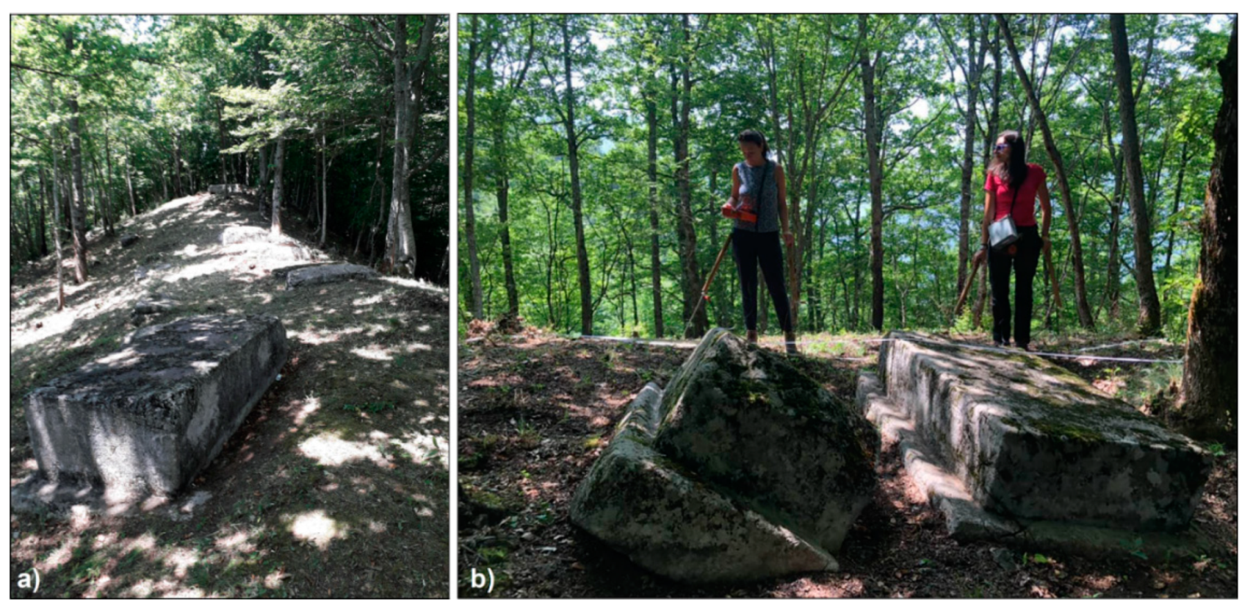
Figure 2.
Mjace: images prior (a) and during (b) the archaeological research of the tower.
Figure 2.
Mjace: images prior (a) and during (b) the archaeological research of the tower.
Figure 3.
Mjace: Google EarthTM satellite images prior (a), during (b) and after (c) archaeological excavation.
Figure 3.
Mjace: Google EarthTM satellite images prior (a), during (b) and after (c) archaeological excavation.
Figure 4.
Mjace: GPR time slices in the range 0–18 ns (a), time slice relative to 9–13 ns overlapped on the satellite image of Google EarthTM (b) and the agglomeration of small stones and broken bricks brought to light by archaeological excavation (c).
Figure 4.
Mjace: GPR time slices in the range 0–18 ns (a), time slice relative to 9–13 ns overlapped on the satellite image of Google EarthTM (b) and the agglomeration of small stones and broken bricks brought to light by archaeological excavation (c).
Figure 5.
Doclea: satellite image of the urban area with indication of architectonical elements and road patterns based on Sticotti’s researches [
66] (modified from ©2018 Google Image).
Figure 5.
Doclea: satellite image of the urban area with indication of architectonical elements and road patterns based on Sticotti’s researches [
66] (modified from ©2018 Google Image).
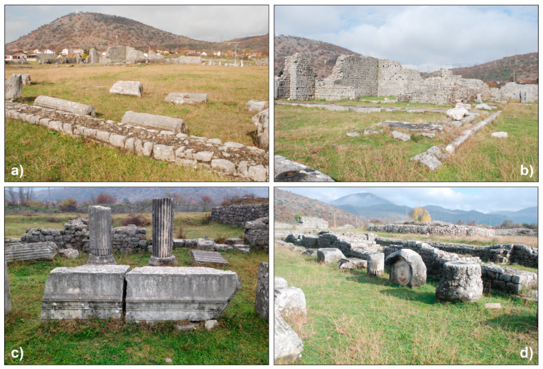
Figure 6.
Doclea: the forum (a), the civil basilica (b) and some details of architectural elements (c,d).
Figure 6.
Doclea: the forum (a), the civil basilica (b) and some details of architectural elements (c,d).
Figure 7.
Doclea: a selection of time slices relative to the southern part of the private house (1 in
Figure 10). The colour scale indicates the measured variation of the amplitude of the electromagnetic signal.
Figure 7.
Doclea: a selection of time slices relative to the southern part of the private house (1 in
Figure 10). The colour scale indicates the measured variation of the amplitude of the electromagnetic signal.
Figure 8.
Doclea: a selection of time slices relative to the southern part of the temple of Diana (2 in
Figure 10). The colour scale indicates the measured variation of the amplitude of the electromagnetic signal.
Figure 8.
Doclea: a selection of time slices relative to the southern part of the temple of Diana (2 in
Figure 10). The colour scale indicates the measured variation of the amplitude of the electromagnetic signal.
Figure 9.
Doclea: a selection of time slices relative to the northern part of the capitolium (3 in
Figure 10). The colour scale indicates the measured variation of the amplitude of the electromagnetic signal.
Figure 9.
Doclea: a selection of time slices relative to the northern part of the capitolium (3 in
Figure 10). The colour scale indicates the measured variation of the amplitude of the electromagnetic signal.
Figure 10.
Doclea: GPR time slice relative to the time window 14–18 ns, overlapped on the satellite image of Google EarthTM (a), identification of anomalies (b) and hypothetical reconstruction of the urban settlement (c).
Figure 10.
Doclea: GPR time slice relative to the time window 14–18 ns, overlapped on the satellite image of Google EarthTM (a), identification of anomalies (b) and hypothetical reconstruction of the urban settlement (c).
Figure 11.
Dolcea: GPR time slice relative to 14–18 ns around the medieval churches 1 and 2 (right) and a picture of an excavated wall after geophysical prospections (left).
Figure 11.
Dolcea: GPR time slice relative to 14–18 ns around the medieval churches 1 and 2 (right) and a picture of an excavated wall after geophysical prospections (left).
Figure 12.
Doclea: GPR time slice relative to 14–18 ns between the thermae overlapped on the photogrammetric image (modified by [
75]) (
a) and a picture of the excavated base of column laying on the southern border of the road (
b).
Figure 12.
Doclea: GPR time slice relative to 14–18 ns between the thermae overlapped on the photogrammetric image (modified by [
75]) (
a) and a picture of the excavated base of column laying on the southern border of the road (
b).
Figure 13.
Municipium S: Electrical resistivity map relative to 1 m in depth on a Google EarthTM satellite image (a) and interpretation of geophysical anomalies (b).
Figure 13.
Municipium S: Electrical resistivity map relative to 1 m in depth on a Google EarthTM satellite image (a) and interpretation of geophysical anomalies (b).
Figure 14.
Municipium S: detail of the electrical resistivity map relative to D area on an image acquired by drone.
Figure 14.
Municipium S: detail of the electrical resistivity map relative to D area on an image acquired by drone.
Figure 15.
Svač: the upper town plan modified by [
82] (
a), buildings 1, 2, 3 reported in
Figure 16 and the surveyed area (4) on a Satellite image of Google Earth
TM (
b).
Figure 15.
Svač: the upper town plan modified by [
82] (
a), buildings 1, 2, 3 reported in
Figure 16 and the surveyed area (4) on a Satellite image of Google Earth
TM (
b).
Figure 16.
Svač: St John Church (
a), Holy Mary Church (
b) and a gate with maybe a church at a top (
c) respectively signed in
Figure 15 with numbers 1–3.
Figure 16.
Svač: St John Church (
a), Holy Mary Church (
b) and a gate with maybe a church at a top (
c) respectively signed in
Figure 15 with numbers 1–3.
Figure 17.
Svač: representations of the electrical resistivity map relative to 1 m in depth using two different colour scales without (a) and with the indication of the main anomalies (b).
Figure 17.
Svač: representations of the electrical resistivity map relative to 1 m in depth using two different colour scales without (a) and with the indication of the main anomalies (b).
Figure 18.
Stećci of Plužine: the biggest tombstone that contains an inscription (a) and a moment of data acquisition (b).
Figure 18.
Stećci of Plužine: the biggest tombstone that contains an inscription (a) and a moment of data acquisition (b).
Figure 19.
Stećci of Novakovići: view of the necropolis (a) and a particular of a tombstone (b).
Figure 19.
Stećci of Novakovići: view of the necropolis (a) and a particular of a tombstone (b).
Figure 20.
Stećci of Žugića: view of the necropolis (a) and a particular of a decorated tombstone (b).
Figure 20.
Stećci of Žugića: view of the necropolis (a) and a particular of a decorated tombstone (b).
Figure 21.
Stećci of Novakovići: electrical resistivity map relative to 1 m in depth using two different colour scales according to which lower resistivity values are visualized through the shades of blue (a) or are made transparent (b).
Figure 21.
Stećci of Novakovići: electrical resistivity map relative to 1 m in depth using two different colour scales according to which lower resistivity values are visualized through the shades of blue (a) or are made transparent (b).
Figure 22.
Stećci of Žugića: electrical resistivity map relative to 1 m in depth using two different colour scales according to which lower resistivity values are visualized through the shades of blue (a) or are made transparent (b).
Figure 22.
Stećci of Žugića: electrical resistivity map relative to 1 m in depth using two different colour scales according to which lower resistivity values are visualized through the shades of blue (a) or are made transparent (b).
Figure 23.
Stećci of Plužine: electrical resistivity map relative to 1 m in depth with indication of probable buried gravestones.
Figure 23.
Stećci of Plužine: electrical resistivity map relative to 1 m in depth with indication of probable buried gravestones.
© 2020 by the authors. Licensee MDPI, Basel, Switzerland. This article is an open access article distributed under the terms and conditions of the Creative Commons Attribution (CC BY) license (http://creativecommons.org/licenses/by/4.0/).

 ,
, 


