GIS Analysis and Spatial Networking Patterns in Upland Ancient Warfare: The Roman Conquest of Dacia


Department of Archaeology, University of Exeter, Laver Building, North Park Road, Exeter EX4 4QE, UK
*
Author to whom correspondence should be addressed.
Geosciences 2021, 11(1), 17; https://0-doi-org.brum.beds.ac.uk/10.3390/geosciences11010017
Submission received: 11 November 2020
/
Revised: 24 December 2020
/
Accepted: 28 December 2020
/
Published: 31 December 2020
(This article belongs to the Special Issue Satellite, Aerial and Ground-Based Remote Sensing for Archaeological and Heritage Research)
Abstract
:Generally seen as natural peripheries, upland landscapes present particular challenges both in terms of living, and of recording past human activity within. LiDAR (light detection and ranging) technology has now brought considerable improvement in our ability to record and map surviving archaeological features, but not necessarily increased our appreciation of local agency. Though the iconic landscape around the Iron Age Dacian capital of Sarmizegetusa Regia (Romania) and its Roman conquest have long caught the attention of specialists and the wider public, both previous research and more recent results from an airborne LiDAR survey leave considerable gaps in our understanding of networking potential across this challenging landscape. Based on LiDAR and satellite-generated high- and mid-resolution topographic data, our paper employs an innovative combination of GIS (geographic information system) spatial analysis tools to examine the spatial relationships between Roman military bases, Dacian targets, and the wider landscape as an integral part of a wider interdisciplinary archaeological research. This helped us formulate and test spatial and historical hypotheses, according to which all known and potential Roman military bases in the study area functioned as part of a system where each contributed individual advantages in securing their domination across the landscape. Our research highlighted the advantages and challenges for Comărnicelu as one of the key Roman logistical nodes, and for the attackers at Şesului and Muncelu working in tandem to besiege and subdue Sarmizegetusa Regia. Our study raises doubts with respect of the fall and destruction of the hillfort at Vârfu lui Hulpe as a result of a Roman siege, making space for alternative political narratives. Ultimately, our findings help build a better understanding of this iconic world heritage landscape and its Roman conquest.
1. Background
Uplands tend to be seen as natural barriers, inhospitable and marginal, where living conditions are more challenging and constraining (see [1] for thorough discussion and bibliography). Indeed, their fragmented topography and climatic regime introduce daily cost and constant challenges, from food cultivation to movement, and from basic air quality to constant threats from climatic extremes. Living in such landscapes usually means that benefits outweigh convenience. Some of the immediate advantages are evident, as throughout time uplands constituted veritable repositories of natural resources to be exploited. Other advantages are occasional, as upland positions provided, for example, desirable upper hand for military operations through hostile territories during war time. In such occasions, uplands provided much-needed cover and safety, and substantially increased possibilities for visual control and speedy intervention across the surrounding landscape.
The landscape is a key factor determining where people could live, where they could produce food or where they could safely transport their produce. Consequently, it also determines the way in which any control agents maintained surveillance of people and activities. In the Roman period, the surrounding landscape became a major factor influencing the distribution of soldiers and forts, and the nature of frontier installations [2]. The Roman army also sought to control natural passes through the mountains, as permanent communication routes established tended to follow river valleys, where control posts were located. This, and the tendency of Roman roads in general to follow river valleys lead most interpreters to believe that Roman armies pattern of movement followed the same lines. However, the functioning of such communication routes was only possible based on securing the strategic control of the surrounding uplands, usually established amid conquest wars, and later enforced through watchtower networks along the frontiers [2]. According to the distribution of temporary encampments, Roman conquest penetration routes follow consistently ridge lines in the uplands of the Iberian Peninsula [3,4,5,6,7,8]. Topographic knowledge and the control of upper positions around target sites was a major concern during ancient warfare [9]. During sieges (e.g., Gamala—see [10]), ramps and towers could be erected to compensate for the lack of helpful natural topographic features (e.g., Jerusalem—see [11]).
Unfortunately, the efficiency of control arrangements is often difficult to assess through traditional, observer-based methods, due to changes in the local landscape since the ancient period and to the state of preservation of the archaeological sites. It is even more difficult to assess lines of connectivity and movement, especially when these have not been converted into permanent roads. However, GIS-based spatial analysis has more recently demonstrated its potential for understanding and modelling ancient movement and perception [12].
Movement and perception are structural mechanisms of human interaction with the natural world, presenting major issues in the way we analyse and interpret archaeological contexts [13]. Based on specific landscape parameters that affect human agency, GIS can assess the likelihood of possible scenarios for the latter, either in more general terms, such as for example an instinctive avoidance of slope steepness [12,14], to the more specific, like the ability of soldiers to network and maintain constant contact with supporting units involved in military operations in hostile territories [2,10].
2. Case Study
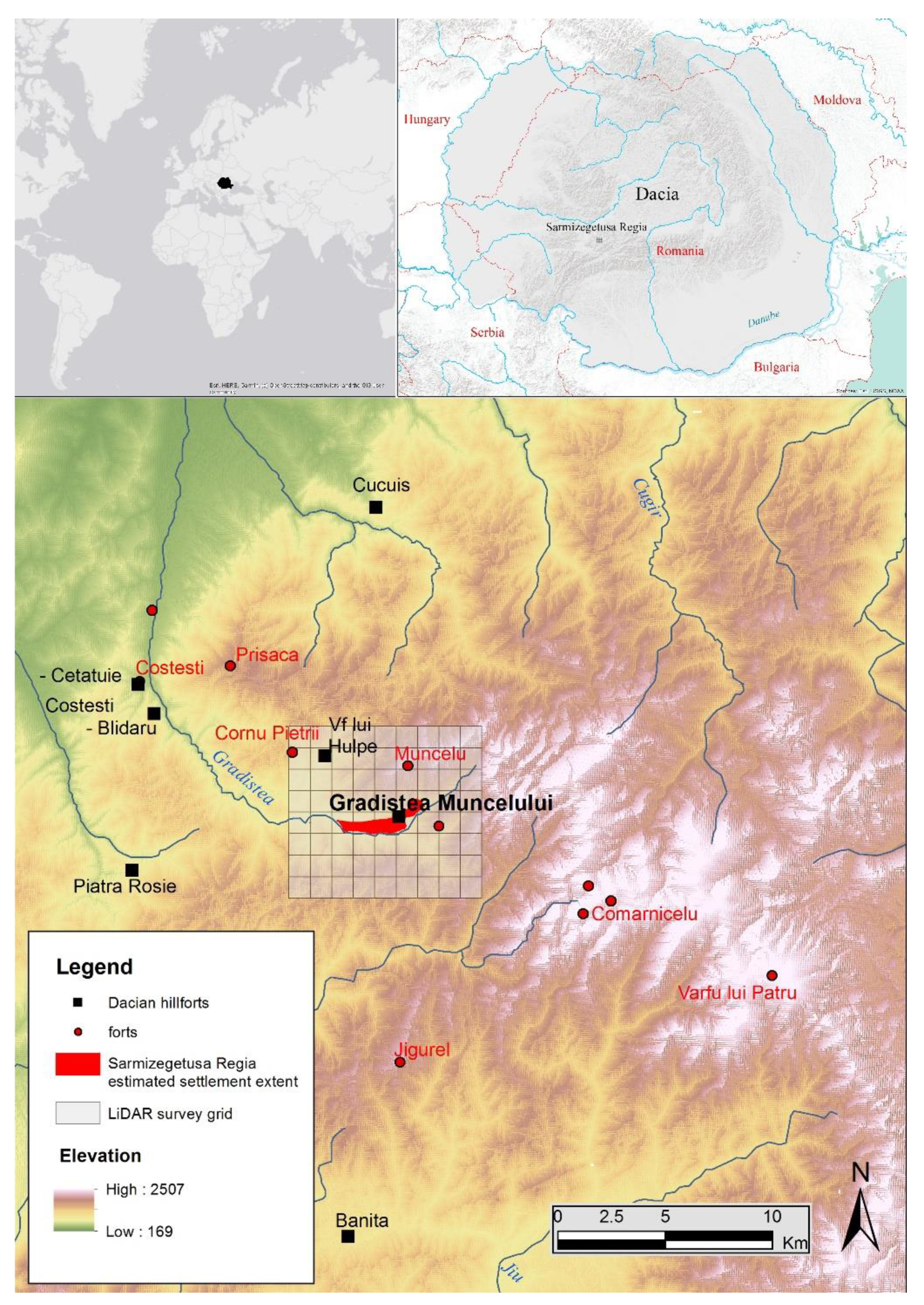
The present study addresses the value of GIS-based spatial analysis tools to assess local agency and Roman warfare in upland landscapes, in the context of Emperor Trajan’s campaigns to conquer the ancient realm of Dacia, in modern Romania. Our understanding of the process of Trajan’s conquest of Dacia relies on contemporary artistic evidence (notably depictions on reliefs of the Trajan’s Column in Rome) and on later historical accounts. Historical sources (most extensively by Cassius Dio many decades after the events) mention a first campaign in 101-2 AD and a second, final one in 105-6 AD. While the first campaign involves a gradual conquest of a series of unnamed native strongholds and advancement towards the central site of the Dacians at Grădiştea Muncelului (Sarmizegetusa Regia; 45°37′18.18″ N 23°18′28.54″ E), the second one focuses exclusively on a strong siege of the latter [15,16]. The political implications are less clear—as a result of a peace agreement in AD 102, the Dacian king Decebalus is maintained until his final fall and eventual suicide during the latter campaign, but more recent research shows that the area may have been much more advanced towards becoming a province than previously assumed [17].
In both campaigns, the assumption is that Roman troops crossed River Danube from army bases in Moesia and Pannonia, moving across the landscape over hundreds of kilometres towards Sarmizegetusa Regia itself (Figure 1). Earlier theories on the movements of the Roman army during the conquest of Dacia have been very crude with respect to their approach to the highly fragmented local topography, with assumptions being based on ethnographic evidence not yet convincingly tested [18]. Trajan’s Column imagery suggests that the Romans’ advance through Dacia had a heavy impact on the local landscape through deforestation and through the construction of roads and other installations and, according to [19], the construction by the Roman army of the road network of Dacia attested by the Peutinger’s Table may have been already underway during the conquest wars. Unfortunately, that itinerary gives no indication of how Sarmizegetusa Regia was accessed from the neighbouring lowlands, and no traces of Roman road have been yet uncovered in the Orăştie Mountains, despite the otherwise good conditions for preservation of archaeological topography.
Such incursions are usually documented archaeologically through evidence of camps accommodating overnight Roman troops on their way to attack indigenous strongholds [20], but the only such sites identified so far in Dacia are in the Orăştie/Şureanu Mountains (part of the Southern Carpathians range) within vicinity of Sarmizegetusa Regia itself (Figure 1). The camps on the Jigurel and Vârfu lui Pătru hills, alongside the three examples clustered on top of Comărnicel hill have been known for some time [21], with another possible example suggested on Prisaca hill [22]. However, all these encampments are located some distance away from any potential Dacian targets and, therefore, have been interpreted as part of army transit towards Sarmizegetusa Regia; the small enclosure on Muncelu hill is the only one traditionally assumed to have played a role in the fall of the target. By contrast, a small camp at Costeşti within immediate proximity of the Dacian citadel on Cetăţuie hill is assumed to be a siege base for that site.
More recently, a reassessment of the archaeological landscape surrounding Sarmizegetusa Regia based on airborne LiDAR evidence [17] demonstrated the value of modern prospection methods and of landscape approaches to advancing the research agenda there. While agreeing with Ştefan’s [19] interpretation of the Muncelu fortification’s character as a permanent, not temporary fortification, it provided substantial new insights into the presence of the Roman army on site and in the area. Thus, it revealed the presence of previously unknown camps on Şesului and on Cornu Pietrii hills, and proposed an extended, multi-period sequence of fortification and destruction on Grădiştea Muncelului hill that involved as many as two separate phases attributable to the Romans, helping us better understand site locations in relation to each other, to strategic targets or to local topography. However, it comes short of providing a clearer understanding of Roman army’s logistics and networking potential, and of its ability to control the surrounding landscape.
3. Material and Methods
An integrated landscape perspective is generally better suited to assist interpretation of the possible date and function of known archaeological sites, to discover new sites and perhaps more importantly, to substantiate possible scenarios on the networking and logistics involved. Tried-and-tested GIS spatial analysis and modelling tools are used throughout this study in an original combination to assess the potential for spatial interrelationship between attacking bases (Roman military camps) and siege targets (indigenous Dacian hillforts), taking into consideration their specific strategic priority to dominate both the mobility and the visibility patterns within this upland landscape. This brings more insight into the strategic role of the Roman army bases from the Orăştie Mountains and their potential interrelationships during the conquest of Dacia.
In the context of this study, the strategic needs of the Roman army would have consisted in their ability to: move securely on the ground and to oversee access paths between bases and towards Dacian hillforts as target for attacks; maintain visual contact with support teams to effectively communicate danger and to orchestrate joint action; and act and react in a timely manner in case of fast developing events.
For this, we have adopted a complex GIS spatial analysis approach using ArcGIS 10.7.1 (Esri, Redlands, CA, USA) to help us model the spatial relationships between Roman military sites, Dacian hillforts and the surrounding landscape based on two available digital terrain models (DTM) (Figure 2). We derived one from a high-resolution LiDAR coverage with 0.5 m of spatial resolution (~8 points per square meter considering all returns; data processed with LAStools (https://rapidlasso.com/lastools/) (version 201124, Rapidlasso GmbH, Gilching, Germany) software dataset for the immediate surroundings of Sarmizegetusa Regia which was already available to us [17]. The second is the freely available NASA developed Shuttle Radar Topography Mission (SRTM); though at a lower resolution of 1 Arc Second ~30 m, it covered the entire area of the Orăştie Mountains. Both these models have limitations. While LiDAR-derived DTMs can be affected by modern-day features or the small-scale natural erosion that can be encountered within the study area (see [23] with bibliography), requiring additional processing to remove or soften these features, the spatial resolution of the more general ones makes them unsuitable for more detailed landscape studies [12,24,25]. Moreover, the digital modelling of specific (paleo) environmental and socio-cultural variables is always complex due to the lack of surviving elements that can affect the results of analysis (e.g., [12,14,26,27,28,29]).
Beyond its contribution to integrating various datasets to reconstruct ancient landscapes and settlement patterns (e.g., [16,30,31,32,33,34,35]), GIS-based spatial analysis has already demonstrated its potential in understanding and modelling ancient movement and perception in upland areas, where physical evidence for ancient paths, tracks and roads is absent (e.g., [29,36,37]). Movement and perception are structural mechanisms of human interaction with the natural world, of ways of being-in-the-world, which makes them key issues in the analysis and interpretation of landscape-based archaeological contexts [13,36]. Our case study moves further and suggests that the control of these elements may even condition social order within certain territories.
In uplands, an elevated position may increase one’s ability to see around a given position, but does not guarantee it. Viewshed calculations are now the standard method to digitally estimate the ability of individuals to see the landscape around them from a given location [38,39]. Binary viewsheds were obtained (using the Viewshed tool in ArcGIS 10.7.1) to assess the effectiveness of visual control from specific sites across the surrounding landscape using OFFSETA (observer height) of 6 m corresponding to the estimated mean height of the Dacian citadel walls and of 2.8 m for the Roman military camps (considering 1.2 m for the height of the rampart and 1.6 m for an average height of the human being). The viewsheds were calculated from several points uniformly distributed within the perimeter of the hillforts and the Roman bases. These were subsequently divided and quantified by different buffers (0.8, 2, 5, and 20 km), to account for short, medium and long visual distances. In addition, total viewsheds (using the Viewshed tool in ArcGIS 10.7.1, with input points in every cell of the LiDAR-derived DTM) and cumulative viewsheds (using the Visibility tool in ArcGIS 10.7.1) were also calculated to assess the visual prominence of sites within the wider landscape and their visual interconnections [39,40,41]. Though vegetation is known to be a major influencing factor in visibility calculations [42], we decided not to factor it in our model as the vegetation at the time should have been relatively sparse given the density of wood-based Iron Age architecture and the industrial scale of metallurgy in the area and documented warfare practices [15,43]. Future work will focus on the fuzziness and direction of viewsheds, in order to assess probability and intentionality of visibility [44,45,46,47,48].
Movement on real terrain involves physical effort (e.g., metabolic energy expenditure), especially on steep upland surfaces [49,50]. There are different cost functions that have been used in the past to estimate the effect of slope on walking speed and energy expenditure [12,14,51]. We have decided to use Llobera & Sluckin [50] ‘zigzagging’ algorithm, which correlates slope crossing with human energy expenditure and is more appropriate for landscapes with steep slopes such as the one in this case study. Least-cost path (LCP) calculation assumes that routes were determined by the least time or energy expenditure required between the start and end points, but different natural and socio-cultural elements can condition the movement and can be incorporated in a friction surface role [12]. According to White [52], LCP analysis “can be broken down into three parts: generating a friction surface, calculating a cumulative cost surface based on a specific origin for travel, and constructing an efficient route from a specific destination back to the origin”. Accordingly, while movement along a flat surface is isotropic, regardless of the direction, movement in the uplands negotiating hilly terrain and steep slopes is anisotropic and takes a different trajectory in each direction [12,53,54]. However, while the slope of the terrain has a major impact on the estimated time required to travel a given distance, other natural and socio-cultural factors may also play a role (e.g., [12]).
Previously employed in ‘predictive’ and ‘postdictive’ approaches [55], LCP analysis is considered an intuitive method to reconstruct the layout of (ancient) roads or paths [56,57,58] or to identify the rationale behind the construction of routes [59,60,61]. In contrast, our case study deals with paths that do not have a physical materialization in the landscape. Therefore, we aimed to identify the main natural routes across the mountains between the Roman military sites (considered a priori as attackers) and the Dacian hillforts (a priori designated as targets), where contemporaneity may not have been yet proven. Previous attempts to move beyond simple LCP calculations between starting point A and a destination (or target) point B, have been attempted through ‘cumulative cost paths’ [62] or through FETE (‘from everywhere to everywhere’) [63,64], to create “travel probability surfaces” akin to dense circulatory systems or road networks [63].
Our study employed a different approach to assess mobility patterns between settlements and their potential inter-relationships that combines LCP analysis and Focal Mobility Networks (for a recent review see [12,65]). Contrary to LCP where fixed start and end points are required, MADO (Modelo de Acumulación de Desplazamiento Óptimo) [66,67] allowed us to calculate optimal paths of movement across the landscape from a given location but without a specific destination, to create a ‘focal mobility network’ [54,55]. This highlighted potential networks of natural mobility across the landscape, which helped us assess with greater confidence the viability of certain natural routes.
According to Herzog [24], “the outcome of the LCP calculations depends not only on the algorithm but also on the cost model, which often includes several cost components” and therefore, in doing so we considered different variables, including slope and river network [25,52,68,69]. Based on our prior knowledge of Roman army strategy and on historic and ethnographic evidence from the study area, we employed the theoretical assumption that the general movement in this area and in this historical context was essentially made through the mountain ridges.
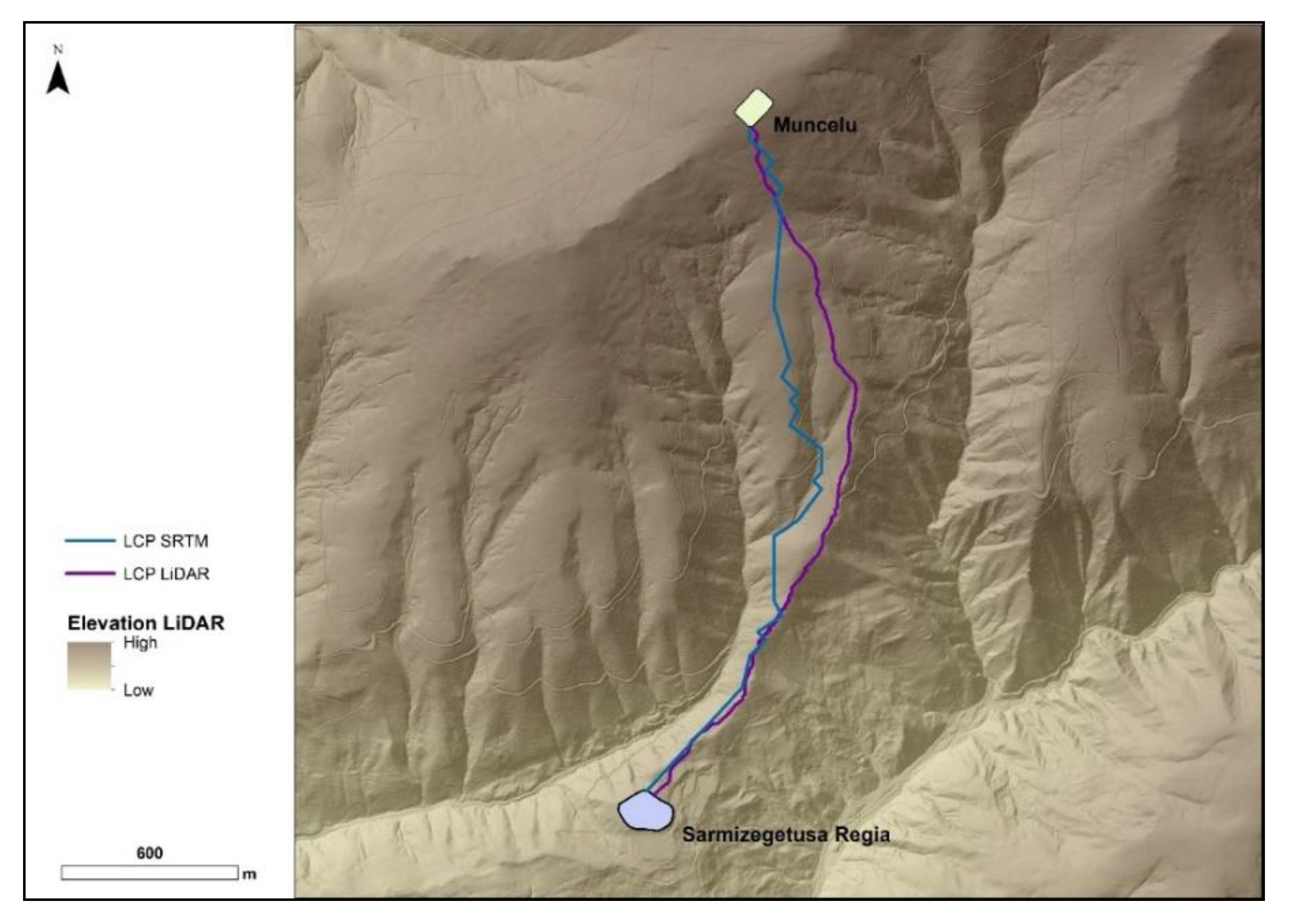
Using the Path Distance tool available in ArcGIS 10.7.1 we calculated an Accumulated Cost Surface (ACS) representing the difficulty of movement in all directions from a given location [67], which quantitatively correlates the slope of the terrain with the human movement effort in biomechanical terms according to Llobera and Sluckin’s [50] function. This relayed on a friction model based on the river network extracted from the DTM using the hydrological tools in ArcGIS 10.7.1 (Fill, Flow Direction, Flow Accumulation, Set Null, Stream Link, Stream Order, Stream to Feature, with watercourses being reclassified and given a higher cost value (equivalent to crossing a slope of 60% according to Llobera and Sluckin’s [50] function) within a buffer equivalent to the DTM spatial resolution. The idea was to prevent the algorithm to consider them as areas suitable for human movement and prioritize as much as possible mobility along mountain ridges [37,69]. Thus, topography, watercourses, slope and energy effort of human movement (according to Llobera and Sluckin’s [50] function) where all considered within the ACS calculation. This formed the basis for our LCP (using the Cost Path tool in ArcGIS 10.7.1) calculations between sites and for MADO focal mobility network analyses (which used the Flow Direction and Flow Accumulation ArcGIS 10.7.1 hydrological tools, with the ACS as input and with the output reclassified according to cell size threshold values for the focal mobility network defined by Llobera et al. [54]). Though the DTM resolution influenced the calculation of mobility routes, especially in relation to negotiating its avoidance of river network and the transit on mountain ridges (Figure 3), it nevertheless allowed us to expand analysis to a broader landscape outside the area of LiDAR coverage. Finally, from the reclassification of the ACS we extracted isochrones to assess the impact of travel time on proposed travel routes. These were obtained through a site catchment analysis of the region accessible from a given site [65,70] with an average speed of 5 km/h applied to human movement. To help interpretation, the catchments were divided into 15 min intervals over a range of up to two hours. These allowed us to estimate the extent to which travel times may have been a factor influencing strategic movement.
4. Interpretation of the Spatial Analysis Results
The GIS spatial analyses performed as part of this research have been successful in highlighting the extent to which Roman army could have dominated efficiently this conflict landscape and defeated Dacian resistance. The main results and their interpretations are discussed below.
4.1. Mobility Route
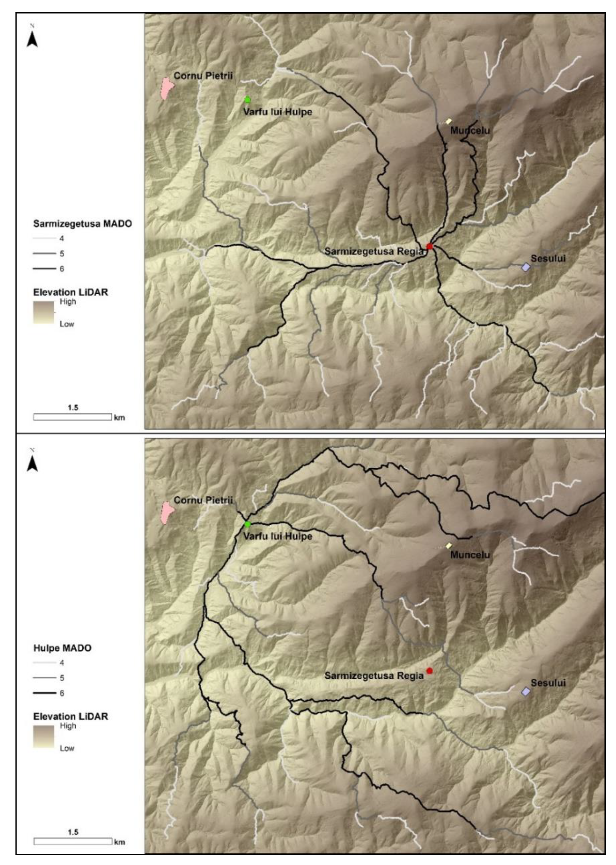
In a siege scenario, a key requirement for the attacking troops is to cut the target’s connections with the outside world. MADO analyses show that, while at Vârfu lui Hulpe no Roman camp hinders any major communication route—thus raising doubts as to whether the hillfort saw any substantial siege at all—at Sarmizegetusa Regia both Roman bases nearby (on Muncelu and Şesului hills) are affecting circulation along main access routes towards north and southeast (Figure 4). Indeed, the northern communication route is cut at Muncelu by two parallel east-west oriented ramparts which seem to precede the permanent fortification and whose function has not been clarified before [17]. Similarly, given the morphological structure and spatial extent of Sarmizegetusa Regia itself rendering less relevant LCP analyses, MADO analyses from Şesului hill and from Muncelu hill successfully highlighted the most efficient routes for their attackers to reach various locations across the site, and the most exposed areas to attack.
Despite its poorer resolution (see above), SRTM data allowed us to extend LCP and MADO to more distant Roman bases to the south, southeast and northwest, to help us identify the broad possible routes travelled by troops from Şesului and Muncelu hills to reach their advanced siege positions (e.g., Figure 5). Travel routes negotiating topography and the time scales involved confirm that a direct attack from either Comărnicelu, Vârfu lui Patru or Jigurel on Sarmizegetusa Regia is less likely and therefore further substantiate their earlier interpretations as transit and distribution sites, as parts of a wider mobility and logistics scheme. The cluster of camps on Comărnicelu hill is ideally located on/in immediate proximity of the shortest natural communication pathways (LCP) between Vârfu lui Patru and either the bases on Muncelu and Şesului, or that on Jigurel hill, as well as for reaching other Dacian targets at Piatra Roşie, Costeşti-Cetăţuie, Vârfu lui Hulpe, or to the Roman base at Prisaca (Figure 5). This confirms Comărnicelu as the key logistical node in the southeast. The Roman advancement from the northwest towards Muncelu hill has been in the past less clear, but the MADO analysis indicates that its natural position allows direct contact with the camp at Costeşti-Cetăţuie. Both MADO and LCP calculations indicate that transiting between Costeşti-Cetăţuie and Muncelu would have been easier and most direct via the Prisaca hill rather than though the camp on Cornu Pietrii hill, which is located much farther to the south from the pathway between Costeşti and Muncelu (Figure 5). If the Roman troops at Cornu Pietrii came there via Costeşti, this happened independently from the route between Costeşti and Muncelu.
4.2. Visibility
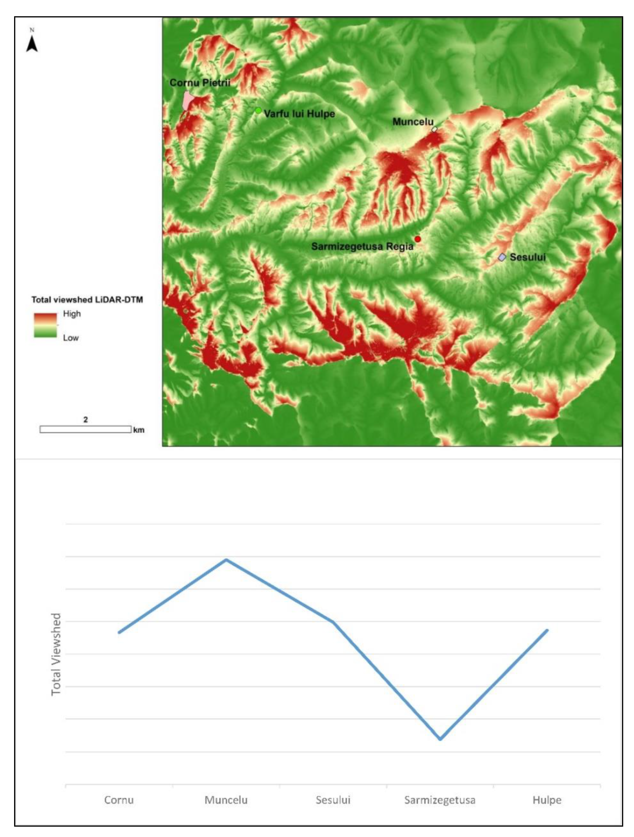
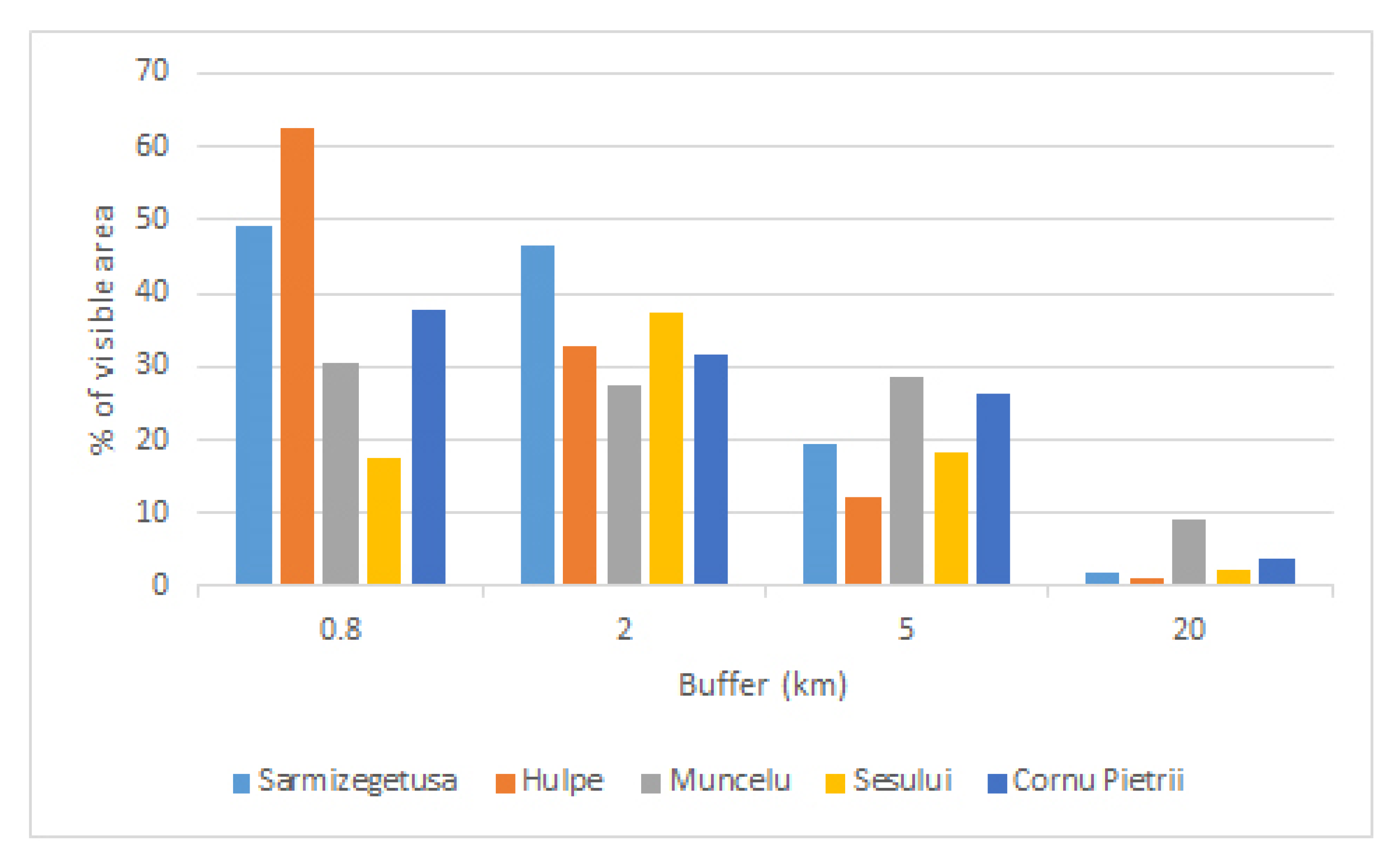
Viewshed analyses allowed us to better estimate the effect of visibility from key sites across the landscape on increasing Roman troops’ ability to control visually their surroundings (immediate and more distant), and how this ability might have impacted on their ability to move across the landscape. While a higher coverage would normally be assumed closer to the viewpoint, at Sarmizegetusa and in its immediate vicinity the highest percentage of immediate coverage is achieved by the two hillforts Sarmizegetusa Regia and Vârfu lui Hulpe, but their visual command ability declines rapidly in the medium and higher distance. However, while the visibility from the Roman camp at Cornu Pietrii follows a similar pattern to that of the hillforts (see above), those from the Roman bases at Muncelu and Şesului are in stark contrast. Şesului distinctly focuses on the lower-mid and higher-mid distance (2–5 km range), while Muncelu secures the most even coverage of the close and mid-distance ranges and the highest coverage of the farther distance (20 km).
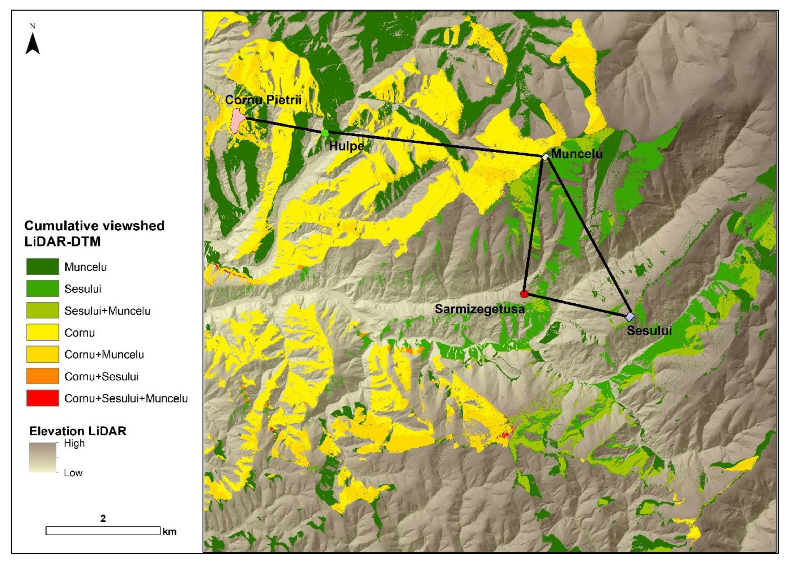
From the three Roman bases closest to Sarmizegetusa Regia, the one with most visual prominence and in higher command over the wider surrounding landscape was at Muncelu hill (Figure 6, Figure 7 and Figure 8). This connected visually with both Şesului and Cornu Pietrii camps and more distant army bases, and Dacian hillforts such as Vârfu lui Hulpe and, further away Piatra Roşie. Surprisingly, it covers very poorly Sarmizegetusa Regia, its likely siege target, and the main approach to it. This is compensated however by the -otherwise more localised- coverage from Şesului hill, and therefore, their visual complementarity could indicate that they had acted as a tandem (Figure 8). The overall visibility from Cornu Pietrii is also fairly limited and, while allowing communication with Muncelu, Costeşti Blidaru, Comărnicelu and Jigurel, it fails to cover the Vârfu lui Hulpe hillfort—a significant inconvenience if warfare was to be conducted from Cornu Pietrii against Vârfu lui Hulpe.
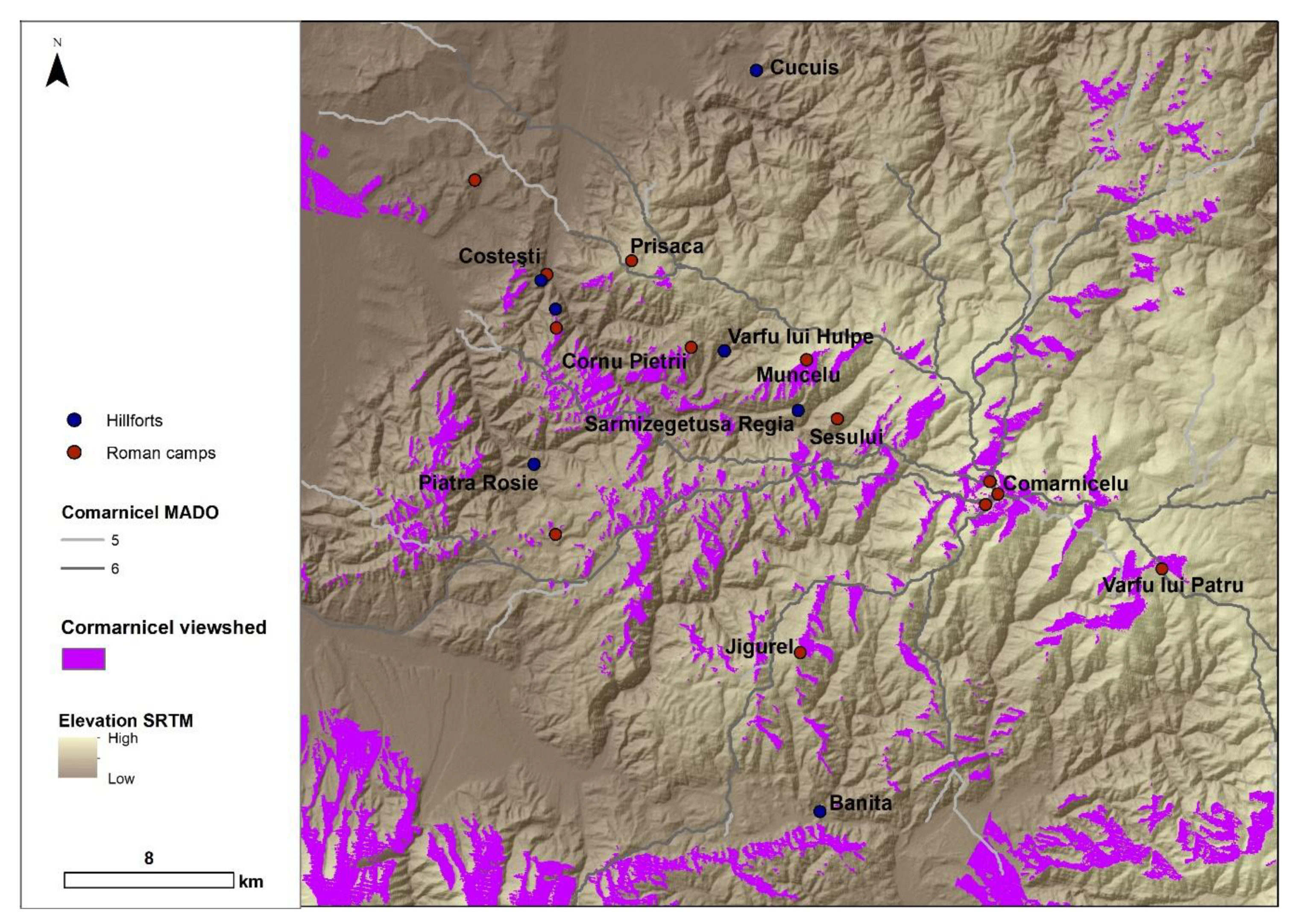
Visibility was important also for safe transit of personnel on the ground. The distribution base on Comărnicelu could see the sites at Muncelu, Vârfu lui Patru, Jigurel and, to some extent Cornu Pietrii, but not Şesului or Sarmizegetusa Regia. Also, its ability to oversee its natural approach lines was patchy, more efficient in the immediate vicinity (Figure 9). By contrast, Muncelu’s ability to overlook its own natural approach lines was more intense at larger distances away.
4.3. Isochrones
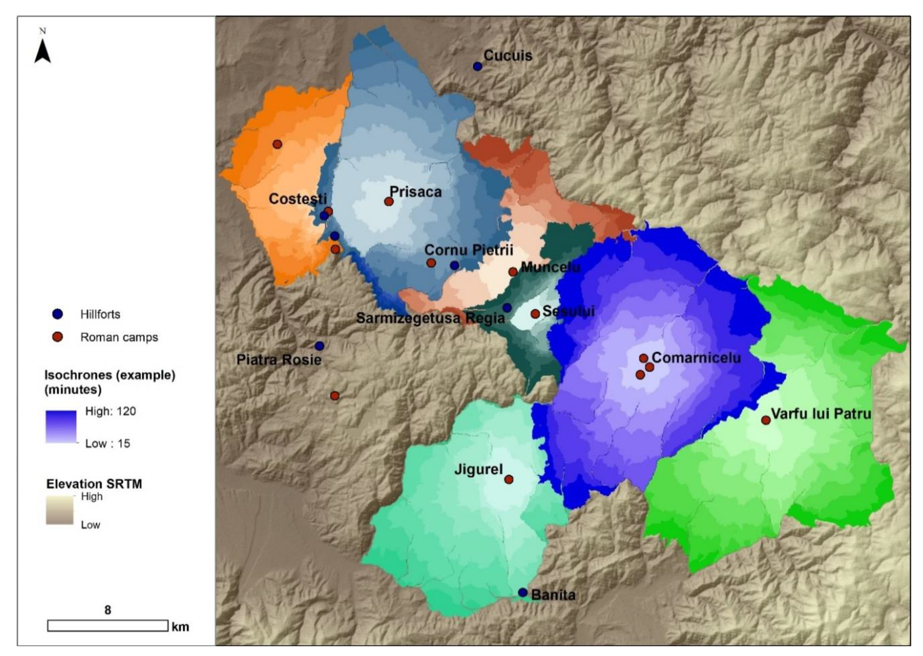
In upland landscapes, the ability of troops to travel rapidly across has key strategic implications, but is heavily and unevenly influenced by local topography. Isochrones calculations give us a convenient baseline on areas which could be reached on foot in 15 min intervals for up to two hours from relevant locations, but each location has its own advantages and challenges. Accordingly, though the overall reach of the camps indicates a fairly systematic coverage of the landscape in between them on both main approaches towards Sarmizegetusa Regia (if Prisaca is to be considered as part of the mobility scheme), at Comărnicelu all camps other than the ones within the cluster itself fall just outside its convenient reach (see Figure 5 and Figure 10). Closer to Sarmizegetusa Regia, both Şesului and Cornu Pietrii camps could be reached comfortably from Muncelu within a two hours interval (Figure 5). However, from Şesului, the base at Muncelu is at the limit of what could be reached within the same amount of time (all other bases requiring considerably longer effort), and from Cornu Pietrii the only reachable base might have been at Prisaca (Figure 10). This indicates that, while the base on Muncelu would have allowed the fastest supply of reinforcements to its immediate friendly neighbours, Şesului and Cornu Pietrii, it would have been more difficult to be supplied in return from either of those. While still able to communicate with each other, the more likely supply connection to Muncelu (and probably Şesului) would have been Comărnicelu. Cornu Pietrii, however, could have been more rapidly connected to Prisaca instead. Travel time was also relevant in assessing the logistics involved in conducting daily attacks against Sarmizegetusa Regia by troops from Şesului hill and Muncelu, where faster access to the walls of the hillfort would have been from Muncelu (15 min) rather than from Şesului (90 min), but the journey back to safety after the attack would have taken much longer to Muncelu (90 min) than to Şesului (75 min). This means that Muncelu was better positioned for fast, surprise attacks, while Şesului was a more reliable option for lengthier, sustained action.
5. Conclusions
If the theoretical assumptions used here to estimate ground movement, visibility and travel time implications are valid, virtually all the existing confirmed or suspected Roman military bases in the Orăştiei Mountains outside Sarmizegetusa Regia would have been needed as part of either the mobility scheme, or for direct warfare against strategic targets. Our analysis confirms that the location at Comărnicelu had the potential to act as an army distribution and coordination node in the advance from southeast towards Sarmizegetusa Regia. While sites like Muncelu or Comărnicelu enjoyed overall better positions than Cornu Pietrii or Şesului, each presented their own advantages, lending weight to their interpretation of operating as part of a strategic system rather than in isolation.
Our research indicates that the distribution of Roman army bases across the landscape secured convenient communication between troops in the area on the ground and visually. Other spatial analyses will be attempted in the future, including to assess probability and intentionality in viewsheds, but based on the results obtained so far, we can already better understand how a siege, while not the solution for conquering Vârfu lui Hulpe, might have succeeded in taking a place like Sarmizegetusa Regia, with Şesului and Muncelu troops relying on each other in order to complete their mission safely and efficiently. Though the morphology of the enclosure itself does not sit comfortably with a temporary, war-time presence at the latter, the spatial analysis presented here highlights the possibility that troops were present at that location to isolate the target and to help the army from Şesului. This theory invites further investigation on the ground, alongside the more general efforts towards a wide scale application of scientific site dating, which would significantly increase the confidence of our spatial modelling. Despite this, by shedding additional light on the practical implications of the Roman army presence and agency in the Orăştiei Mountains during the conquest of Dacia, the research presented here demonstrates the value of our methodology in understanding Roman conquest and warfare.
Author Contributions
Conceptualization, I.A.O.; methodology, J.F.; supervision, I.A.O.; writing—original draft, I.A.O. and J.F.; writing—review & editing, I.A.O. and J.F. All authors have read and agreed to the published version of the manuscript.
Funding
The LiDAR dataset used in this study has been provided to IO by the BBC. An initial processing of the dataset by IO was funded through ArcLand European Comission-funded (Culture Programme 2007–2013—CU7-MULT7 Agreement Number 2010-1486/001-0-01). J.F. was funded by a postdoctoral grant (2016–2019) under the contract between the Galician Innovation Agency (GAIN) and the Spanish National Research Council (CSIC) with the project “The archaeological landscapes of the Roman frontier: comparative perspectives on resources exploitation, social change and imperialism through a non-invasive methodology” (IN606B-2016/002). Both authors are partners in the project “Negotiating and contesting marginal landscapes on the Western fringes of the Roman Empire” funded under the European Union’s Horizon 2020 research and innovation programme under the Marie Skłodowska-Curie (Agreement Number 794048). Thanks to the Roman Society through Donald Atkinson Fund for supporting J.F. visit to Sarmizegetusa Regia and surrounding area in the summer of 2018.
Institutional Review Board Statement
Not applicable.
Informed Consent Statement
Not applicable.
Data Availability Statement
Data available on request from the corresponding author.
Acknowledgments
We would like to thank to Bill Hanson and Rachel Opitz (Glasgow), Michael Doneus (Vienna), for their respective contributions in the initial processing and interpretation of the LiDAR data and to the research team from Grădiştea Muncelului led by Gelu Florea (Cluj Napoca) for assistance with site visits and insight from the ground. Special thanks are owed to Pastor Fábrega-Álvarez (Santiago de Compostela) for technical advice and support with the GIS spatial analysis. Finally, many thanks to those anonymous reviewers who contributed towards improving the quality of our paper.
Conflicts of Interest
The authors declare no conflict of interest.
References
- Carrer, F.; Walsh, K.; Mocci, F. Ecology, Economy, and Upland Landscapes: Socio-Ecological Dynamics in the Alps during the Transition to Modernity. Hum. Ecol. 2020, 48, 69–84. [Google Scholar] [CrossRef] [Green Version]
- Breeze, D.J. The Frontiers of Imperial Rome, Pen and Sword Military, Barnsley; Pen & Sword Military: Barnsley, UK, 2011. [Google Scholar]
- Mayor, J.C.; Hernández, E.M. La Carisa and the Conquest of Asturia Transmontana (Hispania) by Publius Carisius. In Limes XXII: Proceedings of the 22nd International Congress of Roman Frontier Studies, Ruse, Bulgaria, September 2012; Vagalinski, L., Sharankov, N., Eds.; National Archaeological Institute: Sofia, Bulgaria, 2015; pp. 377–385. [Google Scholar]
- Costa-García, J.M. Roman Camp and Fort Design in Hispania: An Approach to the Distribution, Morphology and Settlement Pattern of Roman Military Sites during the Early Empire. In Limes XXIII: Proceedings of the 23rd International Limes Congress in Ingolstadt 2015; Sommer, C.S., Matešić, S., Eds.; Nünnerich-Asmus: Mainz, Germany, 2018; pp. 986–993. [Google Scholar]
- Costa-García, J.M.; Menéndez Blanco, A.; GonzálezÁlvarez, D.; Gago, M.; Fonte, J.; Blanco-Rotea, R.; Álvarez-Martínez, V. The presence of the Roman Army in North-Western Hispania: New archaeological data from ancient Asturias and Galicia. In Limes XXIII: Proceedings of the 23rd International Congress of Roman Frontier Studies Ingolstadt 2015; Sommer, C.S., Matešič, S., Eds.; Nünnerich-Asmus Verlag: Mainz, Germany, 2018; pp. 903–910. [Google Scholar]
- Costa-García, J.M.; Fonte, J.; Gago, M. The reassessment of the Roman military presence in Galicia and northern Portugal trough digital tools: Archaeological diversity and historical problems. Mediterr. Archaeol. Archaeom. 2019, 19, 17–49. [Google Scholar] [CrossRef]
- Morillo, Á.; Adroher, A.; Dobson, M.; Hernández, E.M. Constructing the archaeology of the Roman conquest of Hispania: New evidence, perspectives and challenges. J. Rom. Archaeol. 2020, 33, 36–52. [Google Scholar] [CrossRef]
- Labrador, E.P.; Camino Mayor, J.; Torres-Martínez, J. Recent research on the Cantabrian Wars: The archaeological reconstruction of a mountain war. J. Rom. Archaeol. 2019, 32, 421–438. [Google Scholar] [CrossRef]
- Montgomery, A. Ex opportunitate loci: Understanding Geographic Advantage (Sallust, Bellum Iugurthinum 48.1–53.8). In At the Crossroads of Greco-Roman History, Culture, and Religion: Papers in Memory of Carin M.C. Green; Bell, S.W., Holland, L.L., Eds.; Archaeopress: Oxford, UK, 2018. [Google Scholar]
- Davies, G. Roman Siege Works; Tempus Publishing: Stroud, UK, 2006. [Google Scholar]
- Lendon, J.E. Soldiers and Ghosts. In A History of Battle in Classical Antiquity; Yale University Press: New Haven, CT, USA, 2005. [Google Scholar]
- Verhagen, P.; Nuninger, L.; Groenhuijzen, M.R. Modelling of Pathways and Movement Networks in Archaeology: An Overview of Current Approaches. In Finding the Limits of the Limes. Modelling Demography, Economy and Transport on the Edge of the Roman Empire; Verhagen, P., Joyce, J., Groenhuijzen, M., Eds.; Computational Social Sciences; Springer: Cham, Switzerland, 2019. [Google Scholar] [CrossRef] [Green Version]
- Verhagen, P. Spatial Analysis in Archaeology: Moving into New Territories. In Digital Geoarchaeology. New Techniques for Interdisciplinary Human-Environmental Research; Siart, C., Forbriger, M., Bubenzer, O., Eds.; Natural Science in Archaeology; Springer: Cham, Switzerland, 2018. [Google Scholar]
- Herzog, I. Theory and practice of cost functions. In Fusion of Cultures. Proceedings of the 38th Annual Conference on Computer Applications and Quantitative Methods in Archaeology, Granada, Spain, April 2010; Contreras, F., Farjas, M., Melero, F.J., Eds.; Archaeopress: Oxford, UK, 2013; pp. 375–382. [Google Scholar]
- Oltean, I.A. Dacia. In Landscape, Colonisation and Romanisation; Routledge: Abingdon, UK, 2007. [Google Scholar]
- Oltean, I.A. Sarmizegetusa Regia. In The Encyclopedia of Ancient History; Bagnall, R., Brodersen, K., Champion, C., Erskine, A., Huebner, S., Eds.; Wiley-Blackwell: Hoboken, NJ, USA, 2012. [Google Scholar] [CrossRef]
- Oltean, I.A.; Hanson, W.S. Conquest strategy and political discourse: New evidence for the conquest of Dacia from LiDAR analysis at Sarmizegetusa Regia. J. Rom. Archaeol. 2017, 30, 429–446. [Google Scholar] [CrossRef]
- Daicoviciu, H.; Ferenczi, S.; Glodariu, I. Cetăţi şi Aşezări Dacice în Sud-Vestul Transilvaniei; Editura Ştiinţifică şi Enciclopedică: Cluj-Napoca, Romania, 1989. [Google Scholar]
- Diaconescu, A. Dacia under Trajan, Some observations on Roman tactics and strategy. Acta Musei Napoc. 1997, 34, 13–52. [Google Scholar]
- Jones, R. Roman Camps in Britain; Amberley publishing: Stroud, UK, 2012. [Google Scholar]
- Ştefan, A.S. Les Guerres daciques de Domitien et de Trajan: Architecture militaire, topographie, images et histoire. (Collection de l’École Française de Rome 353); École Française de Rome: Rome, Italy, 2005. [Google Scholar]
- Daicoviciu, C.; Gostar, N.; Crişan, I.H. Şantierul arheologic Grădiştea Muncelului (r. Orăştie, reg. Hunedoara). Mater. Şi Cercet. Arheol. 1959, 5, 379–399. [Google Scholar] [CrossRef]
- Becker, D.; Andrés-Herrero, M.; Willmes, C.; Weniger, G.; Bareth, G. Investigating the Influence of Different DEMs on GIS-Based Cost Distance Modelling for Site Catchment Analysis of Prehistoric Sites in Andalusia. ISPRS Int. J. Geo-Inf. 2017, 6, 36. [Google Scholar] [CrossRef] [Green Version]
- Herzog, I. Least cost paths—Some methodological issues. Internet Archaeol. 2014, 36. [Google Scholar] [CrossRef]
- Herzog, I. A review of case studies in archaeological least-cost analysis. Archeol. Calc. 2014, 25, 223–239. [Google Scholar]
- Kempf, M. Paradigm and pragmatism: GIS-based spatial analyses of Roman infrastructure networks and land-use concepts in the Upper Rhine Valley. Geoarchaeology 2019, 34, 797–808. [Google Scholar] [CrossRef]
- Kempf, M. Modelling multivariate landscape affordances and functional ecosystem connectivity in landscape archaeology. Archaeol. Anthropol. Sci. 2020, 12, 159. [Google Scholar] [CrossRef]
- Carreras, C.; De Soto, P.; Muñoz, A. Land transport in mountainous regions in the Roman Empire: Network analysis in the case of the Alps and Pyrenees. J. Archaeol. Sci. Rep. 2019, 25, 280–293. [Google Scholar] [CrossRef]
- Fabian, L. Moving in the Mountains: GIS and Mapping the Phenomenology of Travel through the South Caucasus. In Landscape Archaeology in Southern Caucasia: Finding Common Ground in Diverse Environments; Anderson, W., Hopper, K., Robinson, A., Eds.; Austrian Academy of Sciences: Vienna, Austria, 2018; pp. 23–35. [Google Scholar]
- Oltean, I.A. Burial mounds and settlement patterns: A quantitative approach to their identification from the air and interpretation. Antiquity 2013, 87, 202–219. [Google Scholar] [CrossRef]
- Oltean, I.A. A Lost Archaeological Landscape on the Lower Danube Roman Limes: The Contribution of Second World War Aerial Photographs. In Archaeology from Historical Aerial and Satellite Archives; Hanson, W., Oltean, I.A., Eds.; Springer: New York, NY, USA, 2013; pp. 147–164. [Google Scholar] [CrossRef]
- Oltean, I.A. A view from the East: The impact of Rome on rural landscapes in Romania. In The Impact of Rome on the British Countryside; Breeze, D.J., Ed.; The Royal Archaeological Institute: London, UK, 2014; pp. 45–51. [Google Scholar]
- Oltean, I.A.; Abell, L.L. High-Resolution Satellite Imagery and the Detection of Buried Archaeological Features in Ploughed Landscapes. In Satellite Remote Sensing. Remote Sensing and Digital Image Processing; Lasaponara, R., Masini, N., Eds.; Springer: Dordrecht, The Netherland, 2012; Volume 16, pp. 291–305. [Google Scholar] [CrossRef]
- Hanson, W.S.; Oltean, I.A. Archaeology from Historical Aerial and Satellite Archives; Springer: New York, NY, USA, 2013. [Google Scholar] [CrossRef] [Green Version]
- Oltean, I.A.; Hanson, W.S. Defining the Roman Limes in Romania: The Contribution of Aerial and Satellite Remote Sensing. In Limes XXII: Proceedings of the 22nd International Congress of Roman Frontier Studies, Ruse, Bulgaria, September 2012; Vagalinski, L., Sharankov, N., Eds.; National Archaeological Institute: Sofia, Bulgaria, 2015; pp. 889–900. [Google Scholar]
- Bell, M.; Leary, J. Pathways to past ways: A positive approach to routeways and mobility. Antiquity 2020, 94, 1349–1359. [Google Scholar] [CrossRef]
- Mahaney, W.C. The Hannibal enigma of 218 BC: A forensic exercise of importance to historical archaeology. Sci. Cult. 2020, 6, 7–24. [Google Scholar] [CrossRef]
- Gillings, M.; Wheatley, D. GIS-Based Visibility Analysis. In Archaeological Spatial Analysis; Gillings, M., Hacıgüzeller, P., Lock, G.L., Eds.; Routledge: London, UK, 2020; pp. 297–313. [Google Scholar]
- Llobera, M. Extending GIS-based visual analysis: The concept of visualscapes. Int. J. Geogr. Inf. Sci. 2003, 17, 25–48. [Google Scholar] [CrossRef]
- Wheatley, D. Cumulative viewshed analysis: A GIS-based method for investigating intervisibility, and its archaeological application. In Archaeology and Geographic Information Systems: A European Perspective; Lock, G., Stancic, Z., Eds.; Taylor and Francis: London, UK, 1995; pp. 171–186. [Google Scholar]
- Llobera, M.; Wheatley, D.; Steele, J.; Cox, S.; Parchment, O. Calculating the inherent visual structure of a landscape (‘total viewshed’) using high-throughput computing. In Beyond the Artefact. Digital Interpretation of the Past. Proceedings of CAA2004, Prato, Italy, 13–17 April 2004; Nicolucci, F., Hermon, S., Eds.; Archaeolingua: Budapest, Hungary, 2010; pp. 146–151. [Google Scholar]
- Llobera, M. Modeling visibility through vegetation. Int. J. Geogr. Inf. Sci. 2007, 21, 799–810. [Google Scholar] [CrossRef]
- Oltean, I.; Fonte, J. Microtopographies of Dacian upland settlement strategies and community aggregation trends in the Orăştie Mountains, Romania. In Rural Settlement: Relating Buildings, Landscape, and People in the European Iron Age; Cowley, D., Fernández-Götz, M., Romankiewicz, T., Wendling, H., Eds.; Sidestone Press: Leiden, The Netherlands, 2019; pp. 251–261. [Google Scholar]
- Brughmans, T.; van Garderen, M.; Gillings, M. Introducing visual neighbourhood configurations for total viewsheds. J. Archaeol. Sci. 2018, 96, 14–25. [Google Scholar] [CrossRef]
- Fábrega-Álvarez, P.; Parcero-Oubiña, C. Now you see me. An assessment of the visual recognition and control of individuals in archaeological landscapes. J. Archaeol. Sci. 2019, 104, 56–74. [Google Scholar] [CrossRef]
- Murphy, K.; Gittings, B.; Crow, J. Visibility analysis of the Roman communication network in southern Scotland. J. Archaeol. Sci. Rep. 2018, 17, 111–124. [Google Scholar] [CrossRef] [Green Version]
- Ogburn, D.E. Assessing the level of visibility of cultural objects in past landscapes. J. Archaeol. Sci. 2006, 33, 405–413. [Google Scholar] [CrossRef]
- Turchetto, J.; Salemi, G. Hide and Seek. Roads, Lookouts and Directional Visibility Cones in Central Anatolia. Open Archaeol. 2017, 3, 69–82. [Google Scholar] [CrossRef]
- Minetti, A.E.; Moia, G.; Roi, S.; Susta, D.; Ferretti, G. Energy cost of walking and running at extreme uphill and downhill slopes. J. Appl. Physiol. 2002, 93, 1039–1046. [Google Scholar] [CrossRef] [Green Version]
- Llobera, M.; Sluckin, T.J. Zigzagging: Theoretical insights on climbing strategies. J. Theor. Biol. 2007, 249, 206–217. [Google Scholar] [CrossRef]
- Herzog, I. The Potential and Limits of Optimal Path Analysis. In Computational Approaches to Archaeological Spaces; Bevan, A., Lake, M., Eds.; Routledge: New York, NY, USA, 2013; pp. 170–211. [Google Scholar] [CrossRef]
- White, D.A. The Basics of Least Cost Analysis for Archaeological Applications. Adv. Archaeol. Pract. 2015, 3, 407–414. [Google Scholar] [CrossRef]
- White, D.A.; Surface-Evans, S. An introduction to the least cost analysis of social landscapes. In Least Cost Analysis of Social Landscapes: Archaeological Case Studies; White, D.A., Surface-Evans, S., Eds.; University of Utah Press: Salt Lake City, UT, USA, 2012; pp. 1–7. [Google Scholar]
- Llobera, M.; Fábrega-Álvarez, P.; Parcero-Oubiña, C. Order in movement: A GIS approach to accessibility. J. Archaeol. Sci. 2011, 38, 843–851. [Google Scholar] [CrossRef]
- Parcero-Oubiña, C.; Güimil-Fariña, A.; Fonte, J.; Costa-García, J.M. Footprints and Cartwheels on a Pixel Road: On the Applicability of GIS for the Modelling of Ancient (Roman) Routes. In Finding the Limits of the Limes; Verhagen, P., Joyce, J., Groenhuijzen, M., Eds.; Computational Social Sciences; Springer: Cham, Switzerland, 2019; pp. 291–311. [Google Scholar] [CrossRef]
- Verbrugghe, G.; De Clercq, W.; Van Eetvelde, V. Routes across the Civitas Menapiorum: Using least cost paths and GIS to locate the Roman roads of Sandy Flanders. J. Hist. Geogr. 2017, 57, 76–88. [Google Scholar] [CrossRef]
- Verhagen, P.; Jeneson, C.F. A Roman Puzzle. Trying to find the Via Belgica with GIS. In Thinking beyond the Tool. Archaeological Computing and the Interpretive Process; Chrysanthi, A., Flores, P.M., Papadopoulos, C., Eds.; Archaeopress: Oxford, UK, 2012; pp. 123–130. [Google Scholar]
- Zohar, M.; Erickson-Gini, T. The ‘Incense Road’ from Petra to Gaza: An analysis using GIS and Cost functions. Int. J. Geogr. Inf. Sci. 2020, 34, 292–310. [Google Scholar] [CrossRef]
- Fonte, J.; Parcero-Oubiña, C.; Costa-García, J.M. A GIS-based analysis of the rationale behind Roman roads. The case of the so-called via XVII (NW Iberian Peninsula). Mediterr. Archaeol. Archaeom. 2017, 17, 163–189. [Google Scholar] [CrossRef]
- Güimil-Fariña, A.; Parcero-Oubiña, C. “Dotting the joins”: A non-reconstructive use of least cost paths to approach ancient roads. The case of the Roman roads in the NW Iberian Peninsula. J. Archaeol. Sci. 2015, 54, 31–44. [Google Scholar] [CrossRef]
- Lynch, J.; Parcero-Oubiña, C. Under the eye of the Apu. Paths and mountains in the Inka settlement of the Hualfín and Quimivil valleys, NW Argentina. J. Archaeol. Sci. Rep. 2017; 16, 44–56. [Google Scholar] [CrossRef]
- Verhagen, P. On the Road to Nowhere? Least Cost Paths, Accessibility and the Predictive Modelling Perspective. In Proceedings of the 38th Annual Conference on Computer Applications and Quantitative Methods in Archaeology, Granada, Spain, April 2010; Contreras, F., Farjas, M., Melero, J.F., Eds.; Archaeopress: Oxford, UK, 2013; pp. 383–390. [Google Scholar]
- White, D.A.; Barber, S.B. Geospatial modelling of pedestrian transportation networks: A case study from precolumbian Oaxaca, Mexico. J. Archaeol. Sci. 2012, 39, 2684–2696. [Google Scholar] [CrossRef]
- Milheira, R.G.; De Souza, J.G.; Iriarte, J. Water, movement and landscape ordering: A GIS-based analysis for understanding the mobility system of late Holocene mound-builders in southern Brazil. J. Archaeol. Sci. 2019, 111, 105014. [Google Scholar] [CrossRef]
- Herzog, I. Spatial Analysis Based On Cost Functions. In Archaeological Spatial Analysis; Gillings, M., Hacıgüzeller, P., Lock, G.L., Eds.; Routledge: London, UK, 2020; pp. 333–358. [Google Scholar]
- Fábrega-Álvarez, P. Moving without destination. A theoretical GIS-based determination of movement from a given origin. Archaeol. Comput. Newsl. 2006, 64, 7–11. [Google Scholar]
- Fábrega-Álvarez, P. Un alto en el camino. Notas acerca del uso de SIG en los análisis de movilidad en arqueología. In Manual de Tecnologías de la Información Geográfica aplicadas a la Arqueología; García, M.C.M., Montes, E.C., Eds.; Museo Arqueológico Regional de Madrid: Madrid, Spain, 2016; pp. 161–182. [Google Scholar]
- Murrieta-Flores, P. Traveling in a prehistoric landscape: Exploring the influences that shaped human movement. In Making History Interactive. Computer Applications and Quantitative Methods in Archaeology (CAA), Proceedings of the 37th International Conference, Williamsburg, VA, USA, 22–26 March 2009; Frischer, B., Crawford, J.W., Koller, D., Eds.; Archaeopress: Oxford, UK, 2010; pp. 249–267. [Google Scholar]
- Fábrega-Álvarez, P.; Parcero-Oubiña, C. Proposals for an archaeological analysis of pathways and movement. Archeol. Calc. 2007, 18, 121–140. [Google Scholar]
- Conolly, J.; Lake, M. Geographical Information Systems in Archaeology; Cambridge University Press: Cambridge, UK, 2016. [Google Scholar] [CrossRef]
Figure 1.
Map of the study area.

Figure 2.
Methodological flowchart.

Figure 3.
Least-Cost Paths (LCP) from Sarmizegetusa Regia to Muncelu calculated from LiDAR and SRTM DTMs.
Figure 3.
Least-Cost Paths (LCP) from Sarmizegetusa Regia to Muncelu calculated from LiDAR and SRTM DTMs.

Figure 4.
MADO (with the highest values of the focal mobility network 4 to 6) from Sarmizegetusa Regia (above); MADO from Vârfu lui Hulpe (below).
Figure 4.
MADO (with the highest values of the focal mobility network 4 to 6) from Sarmizegetusa Regia (above); MADO from Vârfu lui Hulpe (below).

Figure 5.
Results of mobility analysis (LCP and MADO) from the Roman army bases at Comărnicelu (above) and Muncelu (below), indicating area of immediate reach (up to 2 h).
Figure 5.
Results of mobility analysis (LCP and MADO) from the Roman army bases at Comărnicelu (above) and Muncelu (below), indicating area of immediate reach (up to 2 h).

Figure 6.
Total viewshed analysis within the study area based on the LiDAR-generated DTM as map (above) and as relative statistical values (below).
Figure 6.
Total viewshed analysis within the study area based on the LiDAR-generated DTM as map (above) and as relative statistical values (below).

Figure 7.
The percentage of visual coverage around sites at close (0.8 km), lower-mid (2 km), higher-mid (5 km) and distant (20 km) range based on LiDAR data.
Figure 7.
The percentage of visual coverage around sites at close (0.8 km), lower-mid (2 km), higher-mid (5 km) and distant (20 km) range based on LiDAR data.

Figure 8.
Cumulative view calculation and intervisibility lines from the Roman army bases in the vicinity of Sarmizegetusa Regia and Vârfu lui Hulpe Dacian hillforts.
Figure 8.
Cumulative view calculation and intervisibility lines from the Roman army bases in the vicinity of Sarmizegetusa Regia and Vârfu lui Hulpe Dacian hillforts.

Figure 9.
Visibility from Comărnicelu.

Figure 10.
General distribution of isochrones indicating the area of reach within up to 2 h on foot from Roman army bases in the Orăştiei Mountains.
Figure 10.
General distribution of isochrones indicating the area of reach within up to 2 h on foot from Roman army bases in the Orăştiei Mountains.

Publisher’s Note: MDPI stays neutral with regard to jurisdictional claims in published maps and institutional affiliations. |
© 2020 by the authors. Licensee MDPI, Basel, Switzerland. This article is an open access article distributed under the terms and conditions of the Creative Commons Attribution (CC BY) license (http://creativecommons.org/licenses/by/4.0/).
Share and Cite
MDPI and ACS Style
Oltean, I.A.; Fonte, J. GIS Analysis and Spatial Networking Patterns in Upland Ancient Warfare: The Roman Conquest of Dacia. Geosciences 2021, 11, 17. https://0-doi-org.brum.beds.ac.uk/10.3390/geosciences11010017
AMA Style
Oltean IA, Fonte J. GIS Analysis and Spatial Networking Patterns in Upland Ancient Warfare: The Roman Conquest of Dacia. Geosciences. 2021; 11(1):17. https://0-doi-org.brum.beds.ac.uk/10.3390/geosciences11010017
Chicago/Turabian StyleOltean, Ioana A., and João Fonte. 2021. "GIS Analysis and Spatial Networking Patterns in Upland Ancient Warfare: The Roman Conquest of Dacia" Geosciences 11, no. 1: 17. https://0-doi-org.brum.beds.ac.uk/10.3390/geosciences11010017
Note that from the first issue of 2016, this journal uses article numbers instead of page numbers. See further details here.