1. Introduction
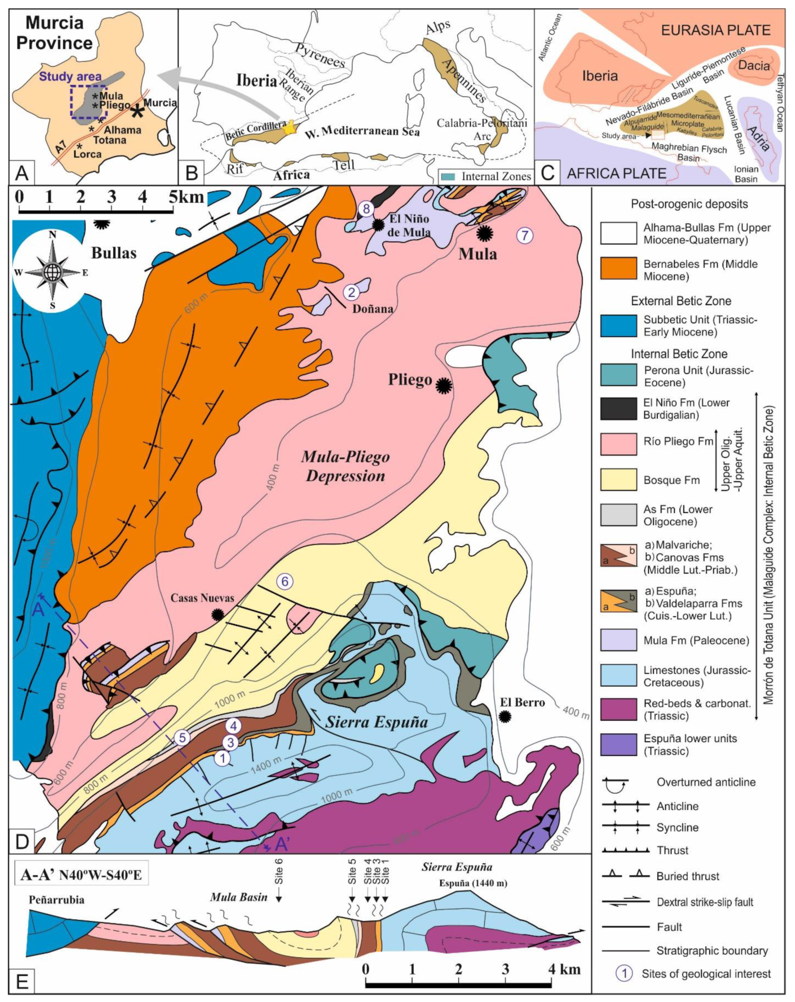
The Sierra Espuña area is located in the Murcia province in SE Spain (
Figure 1A,B). The area is located around the towns of Alhama de Murcia and Totana, to the south, Pliego, in the center, and Mula, to the north (
Figure 1A).
This area belongs to the Malaguide Complex from the Internal Betic Cordillera [
2,
3]. The Internal Zone of this cordillera usually shows metamorphic rocks (Nevado-Filabride and Alpujarride complexes) and only the Malaguide Complex shows a sedimentary (or epimetamorphic) basement and cover. The Betic Cordillera belongs to the Alpine chains of the western Mediterranean area (
Figure 1B) and formed during the Cretaceous to Miocene in response to continental collisions between the Mesomediterranean Microplate and the Iberia-Europe and Africa plates. This led to the closure of seaways and subductions in the western Tethys (
Figure 1C) [
4,
5,
6,
7,
8,
9,
10,
11].
The area exhibits the Mesozoic-Cenozoic cover from the Malaguide Complex, structured in an antiformal stack [
2,
12,
13,
14], in the southern part (Sierra Espuña s.s.). This is followed to the north by a synclinorium (Mula-Pliego Depression) with minor structural highs related to fold-thrust (
Figure 1D,E). The whole area consists of metamorphic (the lower units from the Alpujarride Complex) and sedimentary rocks (the upper two from the Malaguide Complex: Morrón de Totana and Perona units) ranging from the Paleozoic to the Miocene (
Figure 1B). The area has outcrops of good quality and a quite continuous sedimentary record from the Cenozoic succession so that a large number of papers have been published in the area in the last three decades (see below). In particular, the Paleocene to Early Miocene tectono-sedimentary evolution has been the subject of numerous research papers making this basin a key-site for understanding the Cenozoic tectonostratigraphic of the region.
This paper has two scientific focuses: (1) the reviewing of the knowledge of the area, in general, and the Cenozoic, in particular; (2) the proposal of this Cenozoic record as geological heritage. So, this paper aims to show the Cenozoic tectono-sedimentary evolution of the Sierra Espuña as a key area and propose it as a geological heritage. This fact is already mentioned in the previous literature [
2,
3], and references therein) where the quality of outcropping of this tectonic complex from the Internal Betic Zone, is highlighted. To do this, eight sites of geological interest have been selected and evaluated according to recent methodologies [
15,
16].
2. Backgrounds
Former studies in the area were carried out by [
17,
18,
19,
20,
21,
22,
23,
24,
25,
26,
27]. These works introduced the “nappe tectonics” concepts in the area. The involved units were defined and the main structural features of the nappes were established. These studies also proposed a basic stratigraphy and the approximate ages of the sedimentary record.
Studied of the Cenozoic Malaguide Basin in the Sierra Espuña area revived in the late nineties by [
28] and related papers providing new insight into the structure and stratigraphy of the Cenozoic sediments of the area. These papers addressed the timing of deformation in the area, the stratigraphy of Cenozoic formations, and the structure of the Cenozoic sediments [
29]. Detailed works were performed on the early Oligocene As Fm related to the beginning of Cenozoic deformation in the area [
30] and the Paleocene Mula Fm of the Malaguide Complex [
31].
More recent papers related to the structure and/or tectono-sedimentary evolution of the area include [
5,
6,
11,
12,
32]. They redefine the cartographic boundaries, stratigraphy and direction of emplacement of the tectonic units. These authors classified the Cenozoic Malaguide basin of Sierra Espuña as a piggy-back.
The mineralogy and petrography of Cenozoic formations were described by [
2]. Most recently, the Paleocene-Early Eocene platform deposits of the Sierra Espuña area have been recently studied by [
1].
Some books and papers have also been published about the area in recent times highlighting the geological heritage of the area and presenting it to the general public [
33,
34,
35]. These works pointed out some sites of geological interest and georoutes in the area but no evaluation was performed.
3. Stratigraphic Framework of the Cenozoic Malaguide Basin from Sierra Espuña
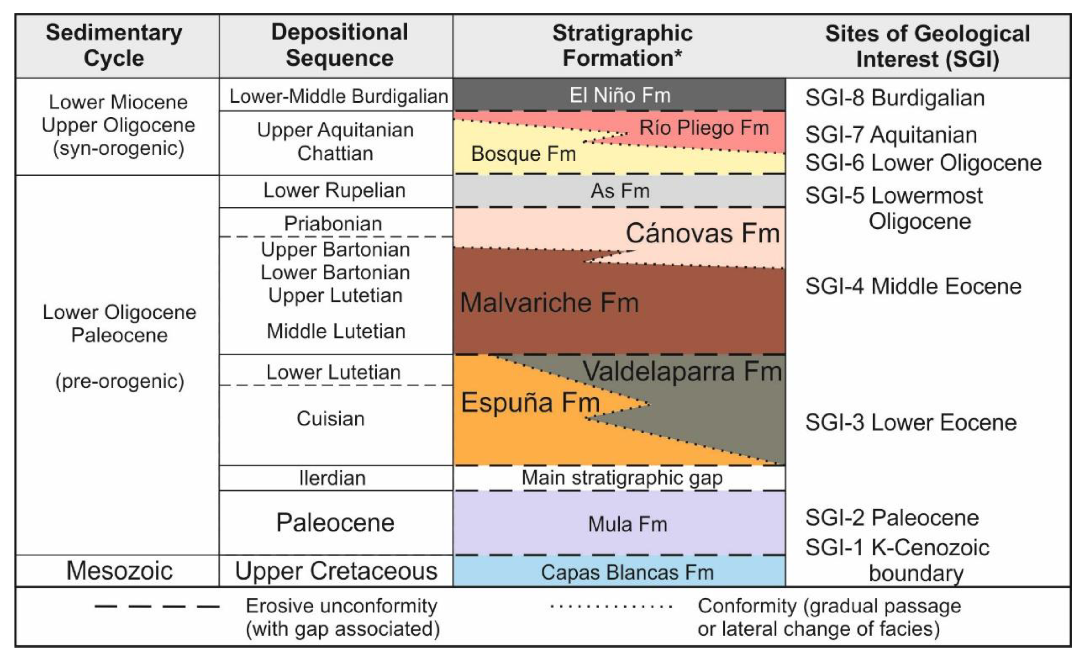
According to literature, the Cenozoic of the Malaguide Complex in the Sierra Espuña area comprises nine stratigraphic formations arranged into two main sedimentary cycles (
Figure 2): the lower one (Paleocene to Earliest Oligocene) is considered pre-orogenic since it is deposited before the older thrusts affecting the Malaguide Complex reached the surface. Nevertheless, flexural tectonics due to basement folding took place during this cycle. The upper cycle (Late Oligocene to Burdigalian) is considered syn-orogenic and deposited contemporaneously to the thin-skin thrusting tectonics which affected the entire Internal Betic Zone.
The pre-orogenic cycle includes six stratigraphic formations separated by lateral changes or unconformities (
Figure 1 and
Figure 2). The older is the Mula Fm (Paleocene) consisting of marine carbonate platform and continental deposits and is separated from the underlying Upper Cretaceous deep marine Capas Blancas Fm by an erosional unconformity with a minor hiatus affecting the Upper Cretaceous
p.p. The Mula Fm is separated from the overlying formations by a stratigraphic gap (unconformity and temporal hiatus) representing the Lower Ypresian (Ilerdian). Following this gap is the Cuisian to Lower Lutetian Espuña Fm, representing an alveoloine-Nummelite platform, and its proximal lateral equivalent, the Valdeparra Fm, consisting of lagoon- and marsh-deposits with coal). The top of both formations is a new erosive contact with minor hiatus associated. It separates the overlying Middle Lutetian to Upper Bartonian alveoline-Nummelites internal platform deposits of the Malvariche Fm. The latter (interfingers) into the marly Nummulite external platform deposits belonging to the Cánovas Fm (Lower Bartonian-Priabonian). The Canovas is unconformably overlain by the Lower Rupelian As Fm, consisting of marshy-lagoonal and deltaic deposits (with quartzite rounded pebbles). The syn-orogenic cycle includes three units (deposited in a syn-tectonic setting) (
Figure 1 and
Figure 2). The Upper Oligocene to Aquitanian Bosque Fm consists of deltaic conglomerate, and limestone to marly platform deposits, which are separated from the underlying As Fm by an erosive unconformity. The Bosque Fm fingers laterally into, and is overlain by turbidites of the Rio Pliego, which in turn are overlain by the Burdigalian deep marine marls, turbidites and silexites of the El Niño Fm. The latter predates the Internal-External Zone Boundary suture [
31]; the back thrusting of the External over the Internal Zone marks the end of the Cenozoic Malaguide Basin.
4. Tectono-Sedimentary Evolution of the Cenozoic Malaguide Basin from Sierra Espuña
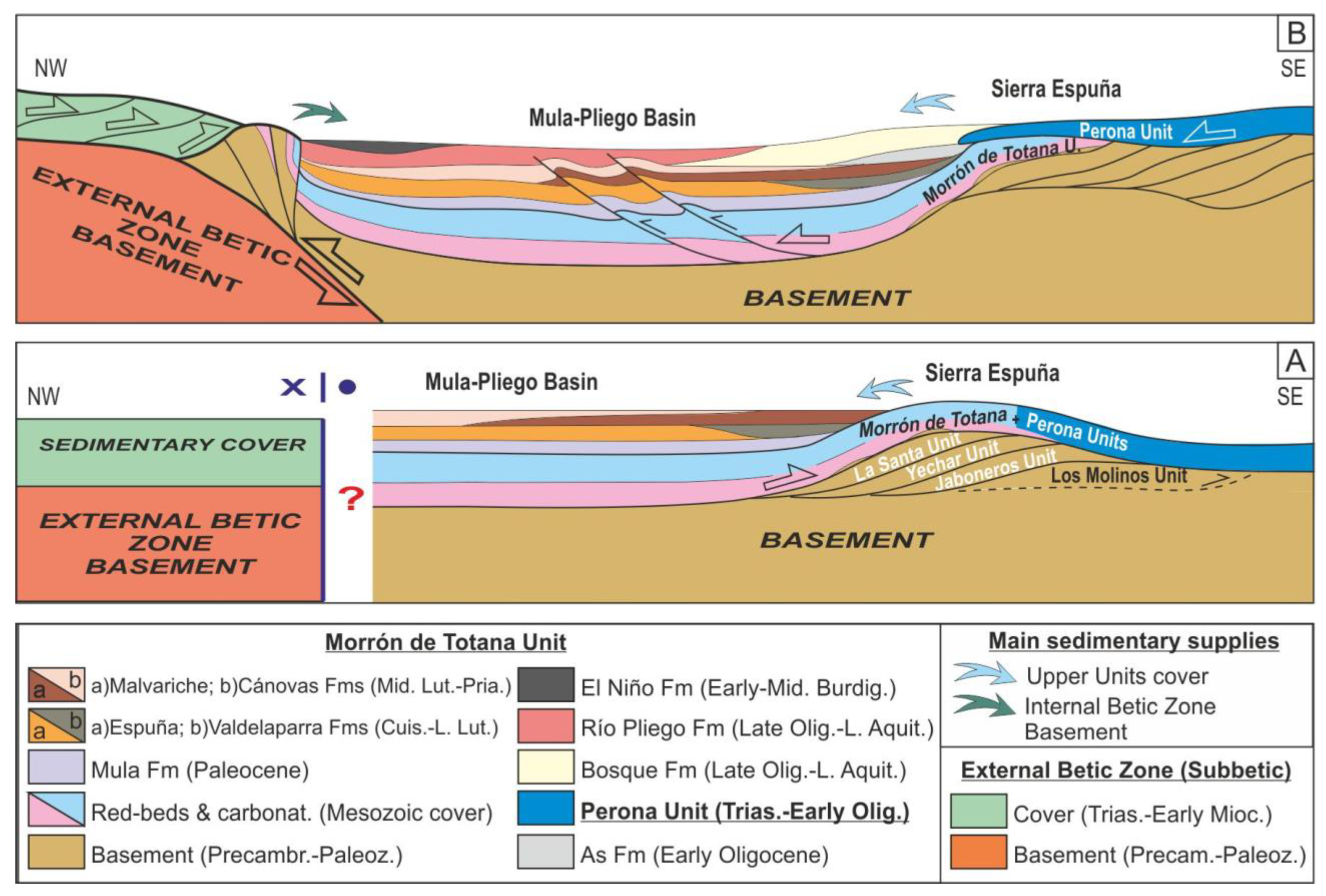
The study area is made up of several Malaguide tectonic units (nappes) divided into lower units (mainly metamorphosed) and upper units (with a sedimentary character) (
Figure 1D). The upper tectonic units are two: the Morrón de Totana unit, in the lower position, and the Perona unit, in the upper position (
Figure 1D and
Figure 3). In turn, the Malaguide units (both lower and upper ones) are thrusting to the Alpujarride tectonic units (in the middle position in the pile of nappes of the Internal Betic Zone). The Cenozoic geodynamic framework of the study area was very complex and marked by different structural stages [
2,
6,
13] that strongly influenced the evolution and sedimentation of the basin. During this period, convergence took place between the Internal Betic Units (belonging to the western and southern margin of the Mesomediterranean Microplate) and the External Betic Units (belonging to the Iberian plate) as represented in
Figure 1C. The convergence started in the Latest Cretaceous, and progressed until the Eocene-Oligocene boundary with the superposition of the Malaguide tectonic units over the lower Alpujarride tectonic units from the Internal Zone (
Figure 3A) [
6,
13]. Later a second superposition stage took place in the Middle Oligocene. In this case, the upper Malaguide Perona unit was up-thrusted over the Morron de Totana one (
Figure 3B), generating related structures in the southern studied area as the Espuña fold. During the Burdigalian, the westward displacement of the Internal Betic Zone and collision against the External Zones probably caused the rotation of the units located along with the Internal–External Zone contact [
6].
The Cenozoic of this area was arranged into two main sedimentary cycles [
6,
8]). The older is: Paleocene to Earliest Oligocene (preorogenic) and deposited contemporaneously to the deep tectonics (
Figure 3A). The younger is Late Oligocene to Burdigalian (syn-orogenic) and deposited contemporaneously to the progression of thrustings in thin skin tectonics affecting the entire Internal Betic Zone (
Figure 3B).
This division is accepted (with minor variation in the age) and equivalent for the Central-Western Alpine Chains (Apennines, Rif, Tell, and Betics). The mentioned evolution is due to the closure of the Tethyan Ocean [
4,
8]. After the tectonic inversion (from spreading to convergence), although this ocean started to close, the compressive conditions only provoked basement folding (deep tectonic) during most of the Paleogene, reflected in the surface by the rising of minor reliefs in the anticlines and the appearance of unconformities and lateral change of facies in the sedimentary record of the basins (usually synclines). This period is considered and mostly accepted in the literature as pre-orogenic. The first important and thin-skin tectonic manifestation took place at the middle Oligocene (just after the As Fm deposition in the study area) when subduction and collision of blocks should take place in the Tethyan area. So, deposition during the Late Oligocene to Miocene is contemporaneous to the nappe tectonic and considered and mostly accepted in the literature as a syntectonic cycle.
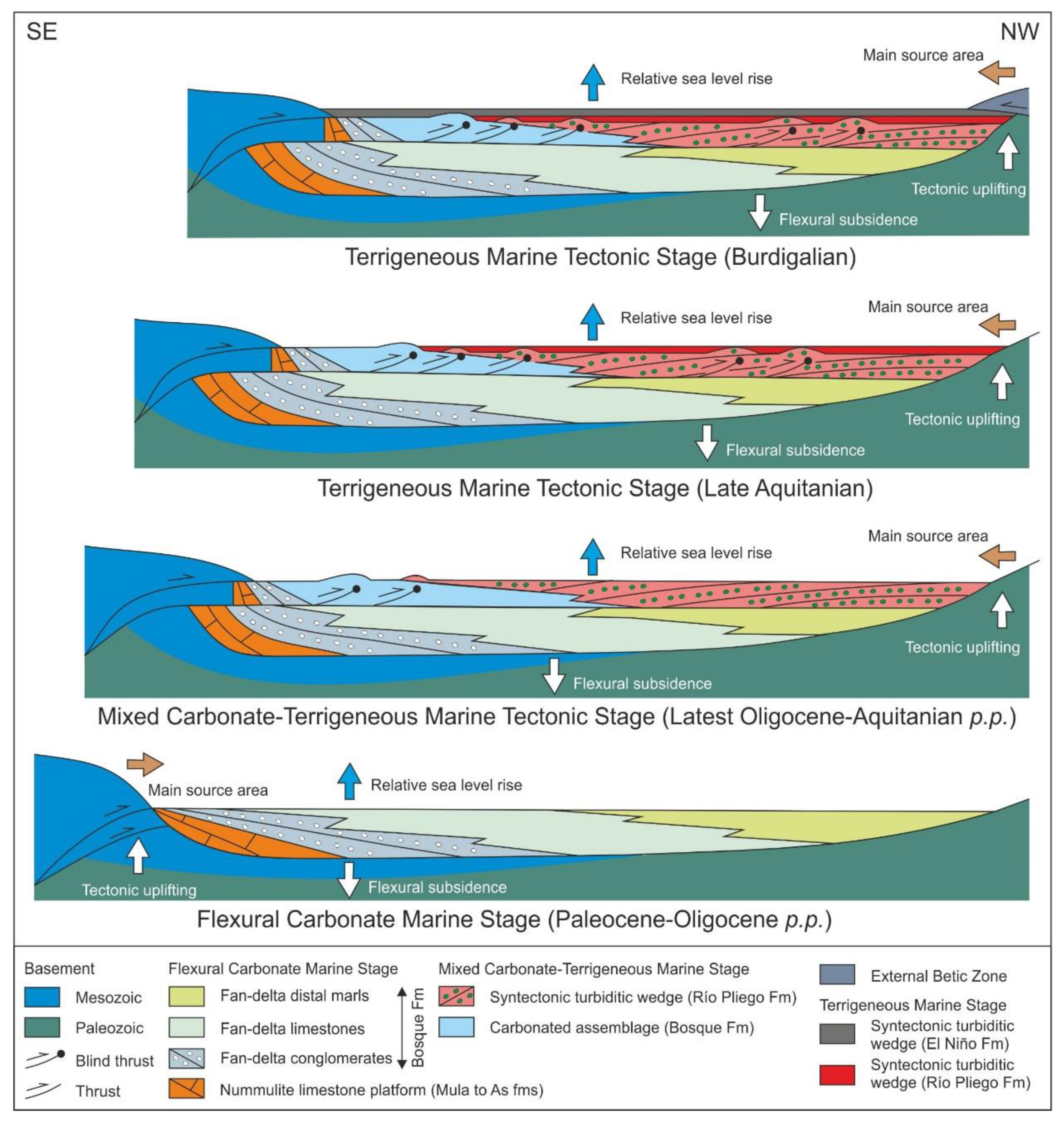
Based on the interpreted tectono-sedimentary evolution, the development of the Cenozoic Malaguide Basin can be divided into three stages [
12] (
Figure 4): (1) a flexural carbonate marine stage during almost the entire Paleogene; (2) a mixed carbonate and terrigenous marine stage during the Latest Oligocene-Earliest Aquitanian; (3) a terrigenous deep marine stage during the rest of the Aquitanian and Burdigalian.
The flexural carbonate marine stage is coincident with the sedimentary pre-orogenic cycle. In this period the terrigenous sedimentation was very scarce and coming from the southern margin of the basin, while tectonics was restricted to basement folding, stacking of units at a deep level, and propagation of blind thrust not manifested at upper tectonic level (
Figure 4).
The following two sedimentary stages coincided with the syn-orogenic evolution of the basin. Mixed carbonate and terrigenous deposition commenced as structures along the basin margins rose above sea-level, particularly in the south, where sediments were sourced from Jurassic to Cenozoic carbonate sediments. During this period, the basin was segmented and compartmentalized by the fold propagation faults, creating a series of local structural highs and subsiding local basins. Finally, the terrigenous deep marine stage clearly shows the paroxysmal tectonics in the area with the main source area from the northern boundary of the basin (basement and Triassic sediments) coincident with a nappe and superficial tectonics.
After this, the Internal Zone was back-thrusted by the External at the Latest Burdigalian, terminating the development of the Cenozoic Malaguide Basin.
5. Sites of Geological Interest
Eight sites have been selected in order to show the tectono-sedimentary evolution of the Cenozoic Malaguide Basin from Sierra Espuña area (
Figure 1D,E and
Figure 2), as follow: (1) Cretaceous-Cenozoic boundary in the Malvariche Valley; (2) the Paleocene Mula Fm in the Doñana sector; (3) the Lower Eocene Espuña and Valdelaparra Fms from Malvariche Valley; (4) the Middle-Upper Eocene Malvariche and Cánovas Fms from Malvariche Valley; (5) the Lowermost Oligocene As Fm from Malvariche Valley; (6) the Upper Oligocene Bosque Fm in the Cejo de las Palomas area (Casas Nuevas); (7) the Aquitanian turbidite Río Pliego Fm in the Mula area; (8) the Burdigalian silexites from the Niño Fm at the El Niño de Mula area.
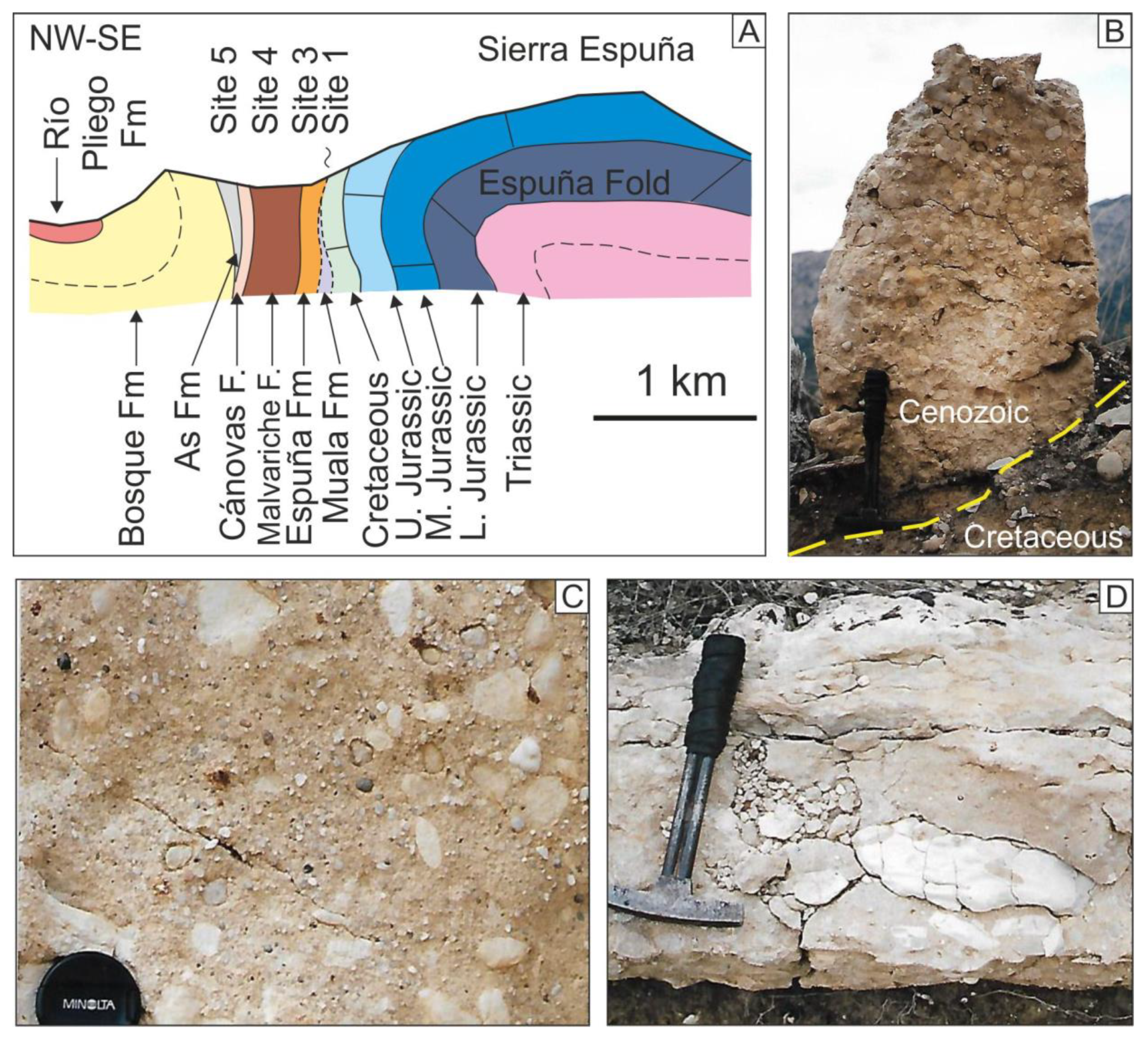
5.1. The Cretaceous-Cenozoic Boundary in the Malvariche Valley
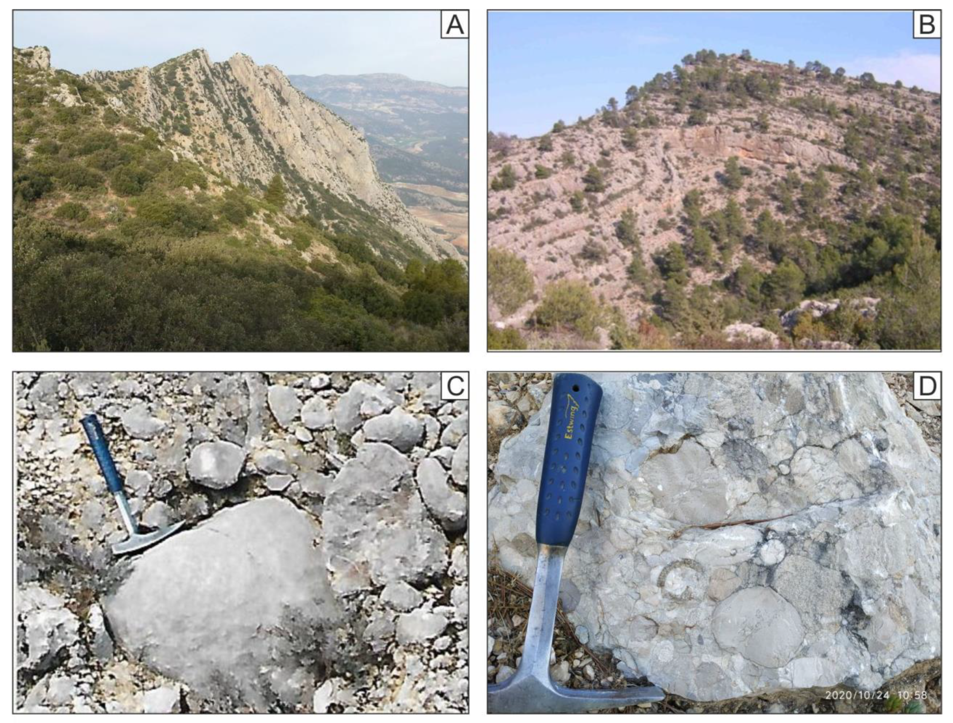
This site is located on the Malvariche forest trail (37°52′34.7″ N 1°36′07.0″ W) from Sierra Espuña (
Figure 1D,E). It was discovered and studied by Martín-Martín [
28] and is considered the best outcrop illustrating the stratigraphic Cretaceous-Cenozoic boundary in the Malaguide Basin. This area belongs to the southern and most active margin of the basin at this period. The area appears structured as a vertical or reversed monocline series belonging to the N flank of the Espuña Fold (
Figure 5A). The Lower Eocene (Cuisian) Espuña Fm directly overlies the Upper Cretaceous Capas Blancas Fm with a cartographic unconformity (
Figure 5A). An erosive gap affecting the entire Paleocene and the Ilerdian (Lower Ypresian) is registered due to the syn-sedimentary deformation (uplifting) of the margin of the basin. The preserved thickness of the Paleocene succession in the central part of the basin varies. Site 1 consists of an outcrop with calcareous conglomerates, marly limestones, and limestone pebbles (
Figure 5B,C) eroded from the underlying Capas Blancas Fm. Rounded quartz grains and pebbles (
Figure 5C) from the erosion of lower quartzite level of the Malaguide cover (Triassic) and basement (Paleozoic) can be found. This level is the first evidence of terrigenous input after the tectonic inversion in which the regional tectonic framework passes from extensional to compressional at the Latest Cretaceous period.
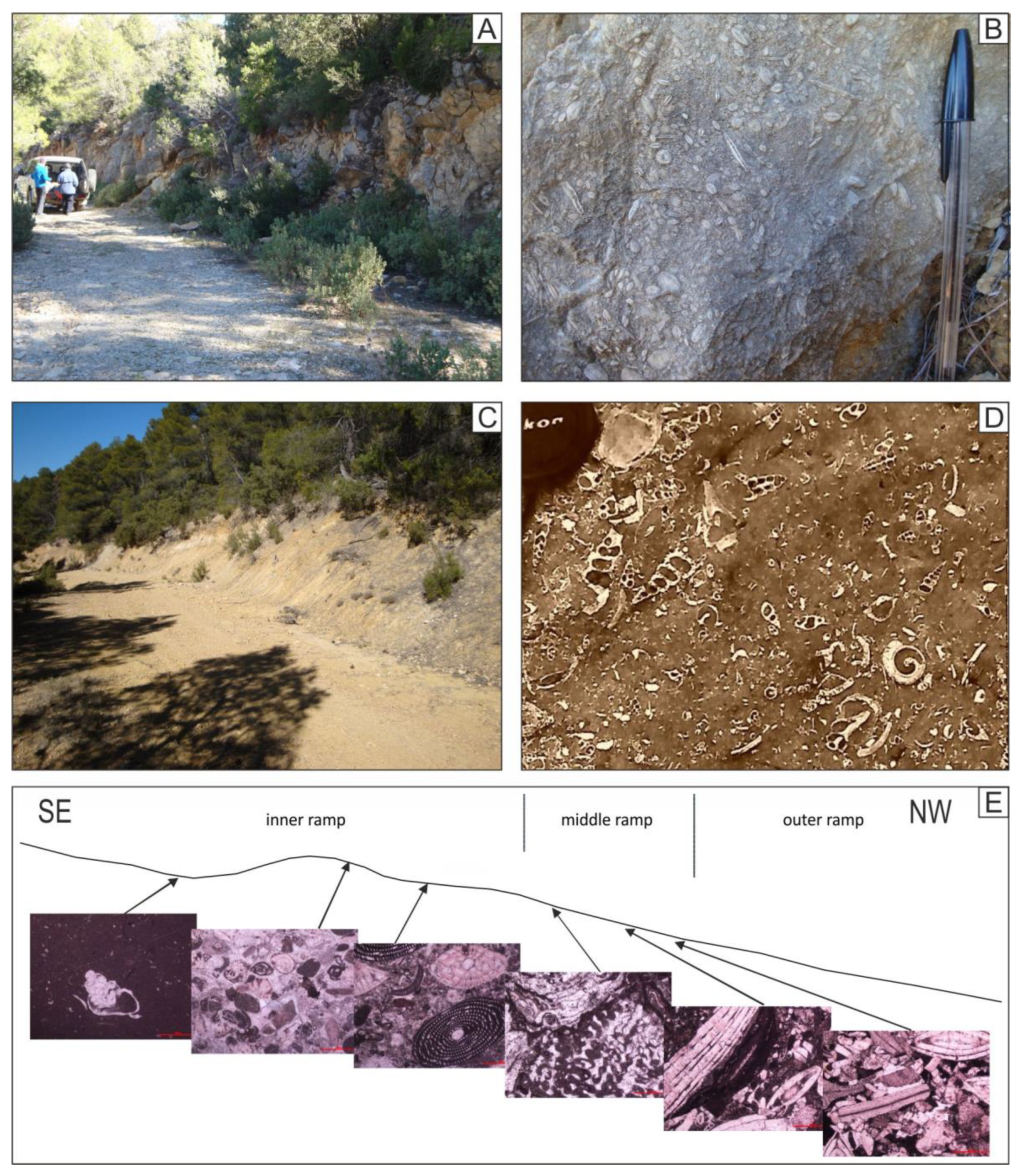
5.2. The Paleocene Mula Fm in the Doñana Area
This site is located in the Doñana area next to the El Niño de Mula location (38°01′34.2″ N 1°32′14.3″ W) from the Mula-Pliego Depression (
Figure 1D). It was discovered and studied by Martín-Martín [
28] and Martín-Martín et al. [
1,
31] and it has been selected as an example of the Paleocene evolution of the basin. The bedding in the area dips gently towards NW. A rhythmic succession is made of greyish limestones and sandy marls outcrops (
Figure 6A,B) representing several environments (from the lagoon to the external platform) of a classic ramp platform with the dominance of larger foraminifera and patch corals. This platform was oriented SE-NW from shallow to deep (
Figure 6C). It belongs to the beginning of the preorogenic cycle of the sedimentation in the basin [
2] when the flexural stage of the basin took place and the antiformal stack and Espuña Fold were created (
Figure 3A and
Figure 4) [
12].
5.3. The Lower Eocene Espuña and Valdelaparra Fms in the Malvariche Valley
This site is located on the Malvariche forest trail (37°52′46.3″ N 1°36′07.7″ W) from Sierra Espuña (
Figure 1D,E). Some papers have been published on this outcrop [
1,
28,
29] and it has been selected as an example of the Lower Eocene evolution of the basin. The area appears structured with an NW dipping as part of the northern flank of the Espuña Fold (
Figure 5A). Espuña Fm (massive of thick stratified carbonate marine platform) and Valdelaparra Fm (lagoon) are two laterally related formations (
Figure 1D). The Espuña Fm consists of alveolina, nummulite, and algal rich limestones and calcarenites (
Figure 7A,B), while the Valdelaparra Fm is made of marshy whitish to cream marls rich in gastropods with intercalation of black lignite levels (
Figure 7C,D).
Both stratigraphic formations represent several environments (from the lagoon to the middle platform) of the ramp platform with the dominance of larger foraminifera and algae. This platform was oriented SE-NW from shallow to deep (
Figure 7E). During this period the flexural stage of the basin, the antiformal stack, and Espuña Fold formation were still ongoing (
Figure 3A and
Figure 4) [
12].
5.4. The Middle Eocene Malvariche and Cánovas Fms in the Malvariche Valley
This site is also located on the Malvariche forest trail in the Malvariche Valley (37°53′14.5″ N 1°35′59.8″ W) from Sierra Espuña (
Figure 1D,E and
Figure 8A). It was previously studied [
28,
29] and it has been selected as an example of the Middle Eocene evolution of the basin. The area is part of the northern (reversal) flank of the Espuña Fold showing a SE steep dip (
Figure 5A). In a reversed succession Cánovas Fms upwardly appears with a gradual passage over the Malvariche Fm (
Figure 8A). Malvariche Fm represents the internal and middle marine platform, while Canovas Fm was deposited in the external platform. The Malvariche Fm consists of alveolina, nummulite, and algal rich massive (or thick stratified) limestones and calcarenites (with similar facies to the Espuña fm) (
Figure 8B,C) with local marly intercalations. The Cánovas Fm is made of pinkish marls (with local calcarenite level intercalations) rich in flat larger foraminifera (
Figure 8D,F) and solitary corals (
Figure 8E). In the marls, planktonic foraminifera appear. Both stratigraphic formations represent again several environments (from the lagoon to the external platform) of the ramp platform with the dominance of larger foraminifera and algae and oriented S-N from shallow to deep).
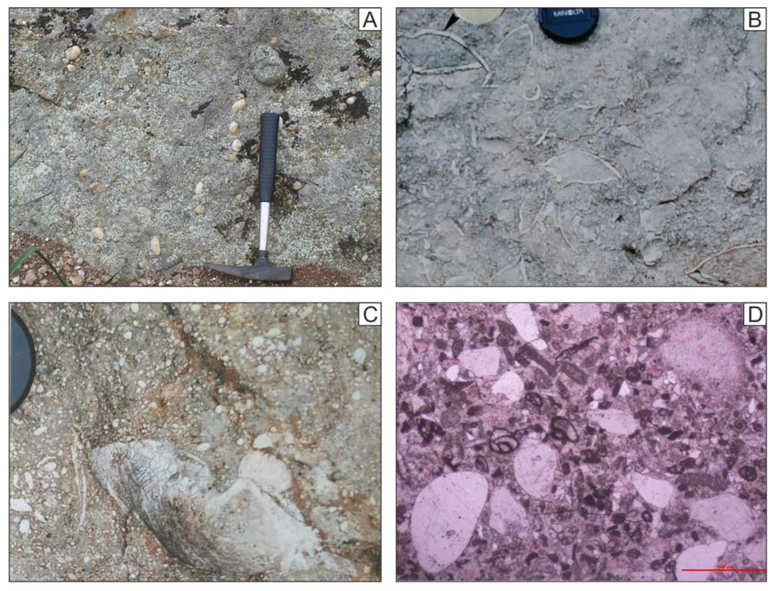
5.5. The Lowermost Oligocene As Fm in the Malvariche Area
This site is also located on the Malvariche forest trail (37°52′57.6″ N 1°36′43.4″ W) from Sierra Espuña (
Figure 1D). It was previously studied [
28,
29,
30] and it has been selected as an example of the Lowermost Oligocene evolution of the basin. The area appears structured with a reversal SE steep dip as part of the northern flank of the Espuña Fold (
Figure 5A). This stratigraphic formation is made of limestones, calcarenites, and yellowish marls with rounded quartz pebbles and occasional bivalves (
Figure 9A–D) outcropping unconformably overlaying the former Eocene succession (
Figure 1D). This formation represents the deposits of an internal platform or lagoon with bivalves (
Figure 9B,C) and benthonic foraminifera (
Figure 9D) affected by the beginning of the main terrigenous supply in the basin fed from the incipient southern rising area of Sierra Espuña. This stratigraphic formation is very important since it belongs to the end of the pre-orogenic cycle. It is involved in the first thrustings of the area predating the beginning of thin skin tectonics in the area [
2,
29,
30]. The deposition of this stratigraphic formation took place when the flexural stage (
Figure 4) of the basin was ending [
12]. This site has been selected as an example of the Lowermost Oligocene evolution of the basin (
Figure 3B). In fact, the age of this nappe phase was debated in the literature and until the nineties considered Eocene in age as in the Pyrenees (Paquet, 1966 [
20]; Lonergan, 1991 [
14]). This changed when the As Fm, involved in the nappes, was dated as Early Oligocene [
30]. The new characterization of the As Fm allowed the relocation of the first nappe tectonic phase at the middle Oligocene.
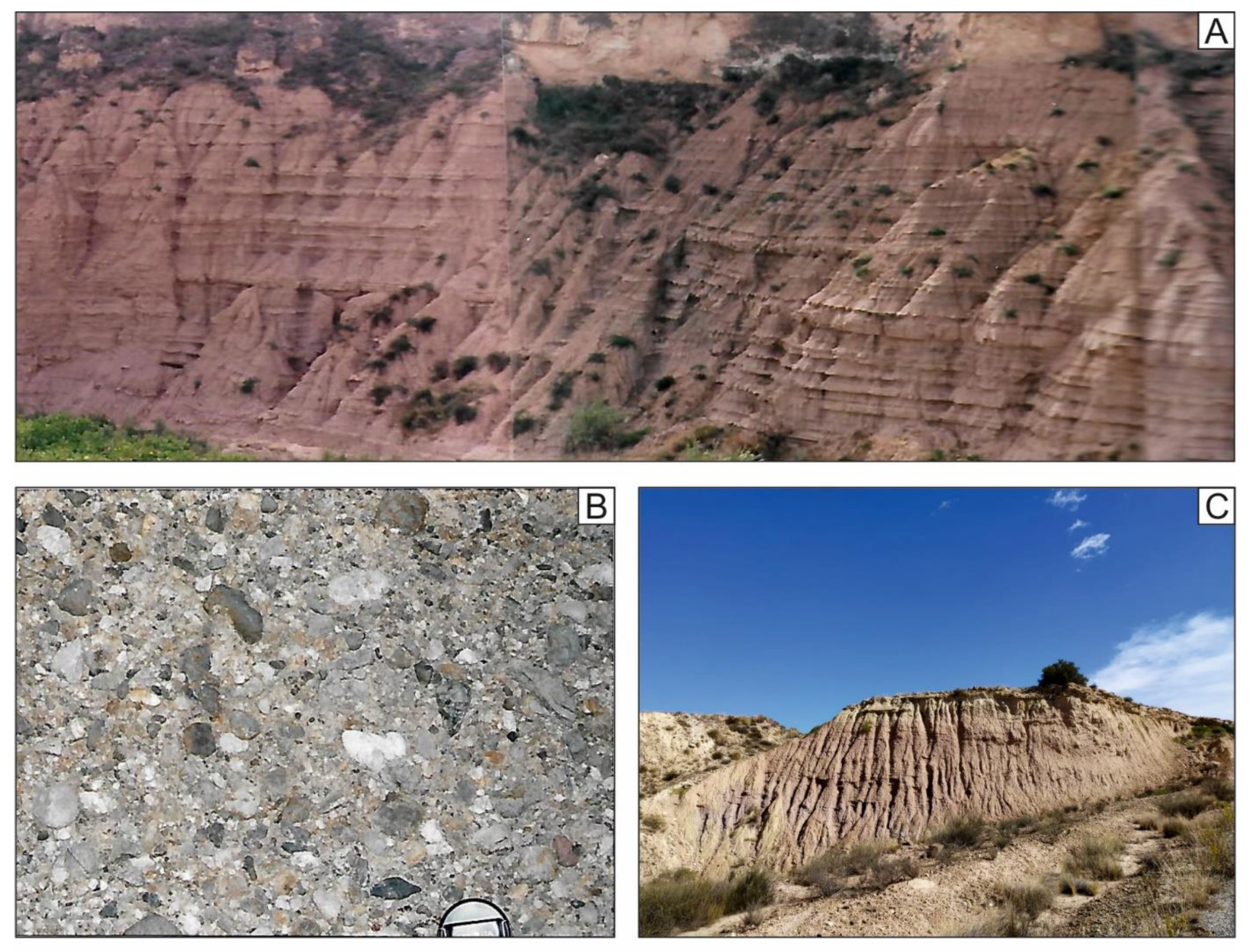
5.6. The Upper Oligocene-Lower Aquitanian Bosque Fm in the Casas Nuevas Area
This site is located near Casas Nuevas on the Canal del Taibilla forest trail (37°55′34.6″ N 1°34′08.7″ W) in the Mula-Pliego Depression (
Figure 1D). This stratigraphic formation crops out in the Umbría del Bosque (
Figure 10A) and Casas Nuevas area (
Figure 10B) and it was previously studied [
12,
28,
29] and it has been selected as an example of the Upper Oligocene-Lower Aquitanian evolution of the basin. The area is situated in a minor anticlinal fold inside the Mula-Pliego Depression (
Figure 10B). This stratigraphic formation is made of conglomerates (mainly carbonate clasts:
Figure 10C,D), limestones, calcarenites, and yellowish marls outcropping unconformably overlying the former succession but also postdating the tectonic phase with the stacking of the upper units from Sierra Espuña (
Figure 3B). This formation represents the deposits of a fan delta transitioning to an internal platform fed from the southern rising area of Sierra Espuña. This stratigraphic formation is very important since it belongs to the beginning of the syn-orogenic cycle. It postdates the first thrustings in the area but is deformed and involved in the paroxysmal phase of deformation of the area [
2,
12,
29,
30]. Deposition of this stratigraphic formation accounted when mixed carbonate and terrigenous stage of the basin took place (
Figure 4). It was deposited contemporaneously to the tectonic compartmentation of the basin due to the appearance of structural highs and subsiding areas in response to the propagation of the structures from S to N (
Figure 3B) [
12].
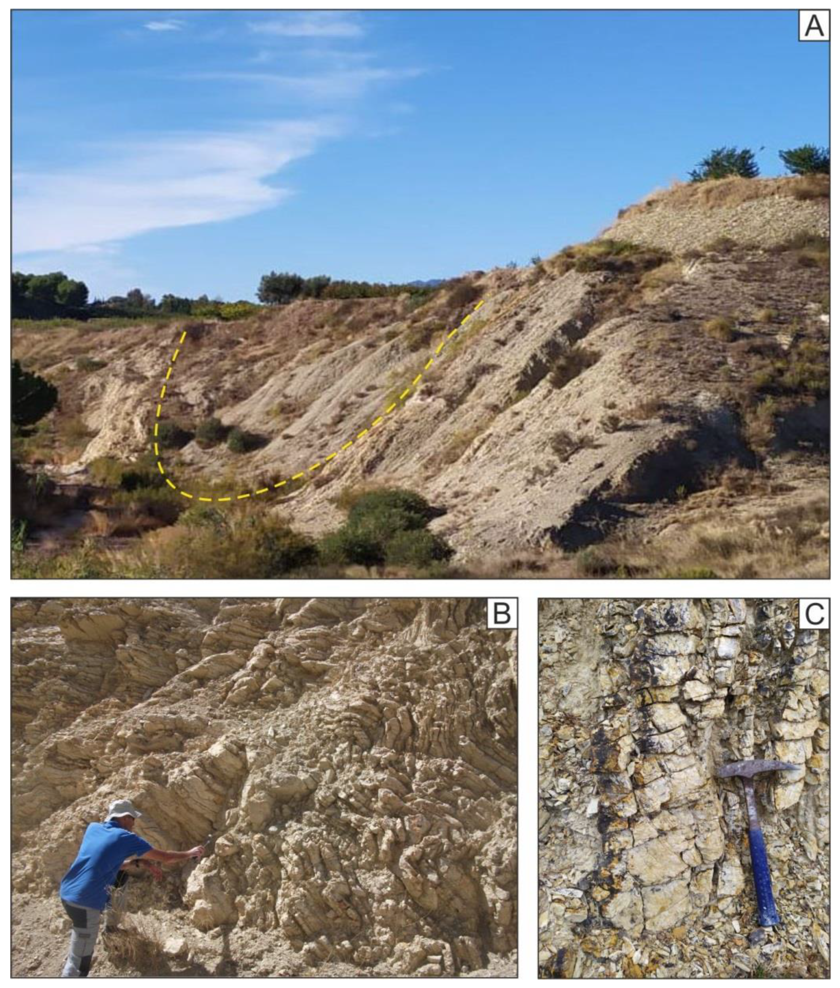
5.7. The Upper Oligocene-Aquitanian Río Pliego Fm in the Mula Area
This site is located in the Río Pliego River near Mula (38°01′52.0″ N 1°27′35.8″ W) in the Mula-Pliego Depression (
Figure 1D). The area exhibits a monoclinal and subhorizontal succession. It was previously studied [
12,
28,
29] and it has been selected as an example of the Upper Oligocene-Aquitanian evolution of the basin when a terrigenous turbiditic wedge was deposited (
Figure 4) fed from the northern margin that became the active one at this time [
12]. This stratigraphic formation consists of a rhythmic succession (
Figure 11A) made of reddish, sandstones (Ta-e, Tb-e) (
Figure 11A), polygenic conglomerates (
Figure 10B), and reddish to yellowish pelites (
Figure 10C) of turbiditic origin. The conglomerates are mainly made of greenish Paleozoic greywackes, reddish Triassic sandstones, and quartzose conglomerates, and whitish Mesozoic limestones. The Rio Pliego Rm stratigraphically overlies the Bosque Fm. However, the lower part of the Rio Pliego Fm exhibits a lateral transition from the Bosque Fm, showing it to be partly contemporaneous to the latter (
Figure 1D). The importance of this stratigraphic formation is due to its belonging to the syn-orogenic cycle since it is deformed and involved in the paroxysmal phase of deformation of the area [
2,
12,
29,
30] when the terrigenous stage of the basin took place, contemporaneously to the compartmentation of the basin due to the appearance of structural highs and subsiding areas as the response of the propagation of the structures from S to N (
Figure 3B) [
12].
5.8. The Burdigalian El Niño Fm in the Mula Area
This site is located close to El Niño de Mula village near Mula (38°02′51.9″ N 1°32′17.2″ W) in the Mula-Pliego Depression (
Figure 1D). The area is situated in a minor synclinal fold inside the Mula-Pliego Depression (
Figure 12A). It was previously studied [
28,
29] and it has been selected as an example of the Burdigalian evolution of the basin when a general deepening of the basin took place. This stratigraphic formation consists of polygenic breccias, sandstones, and greenish pelites of turbiditic origin, but also whitish silexite beds (
Figure 12B,C). This formation upwardly appears to the Río Pliego Fm. A regional unconformity with a minor erosive gap coincident with the Aquitanian-Burdigalian boundary separates both stratigraphic formations. This stratigraphic formation is very important since it belongs to the end syn-orogenic cycle. This formation appears deformed and involved in the paroxysmal phase of deformation of the area [
2,
12,
29,
30] when the terrigenous stage of the basin took place, contemporaneously to the beginning of the erosion of the basin as a response to the propagation of the structures from S to N and emersion (
Figure 3B and
Figure 4) [
12].
The eight sites demonstrate the tectonostratigraphic development of the basin in terms of changes to depositional environments, sediment sources, and tectonically driven topographic changes (
Figure 3,
Figure 4,
Figure 5,
Figure 6,
Figure 7,
Figure 8,
Figure 9,
Figure 10,
Figure 11 and
Figure 12).
6. Evaluation of the Sites
A quantitative assessment of the sites has been performed following the methodology proposed by Brilha [
15] and Aoulad-Sidi-Mend [
16], where four different groups of criteria are evaluated separately: Scientific Value (SV), Potential Educational Use (PEU), Potential Touristic Use (PTU) and Degradation Risk (DR). Values 1, 2, 3, and 4 can be assigned to each criterion (in the case of SV value 3 is not used). These values are also weighted according to a percentage according to Brilha [
15].
Seven criteria (Brilha, 2016 [
15]) are used for the Scientific Value (SV) group: representativeness (R), key locality (Kl), Scientific knowledge (Sn), Integrity (I), Geological diversity (Gd), Rarity (Ra), and Use limitations (Ul).
- -
Representativeness is the capacity of a site to illustrate geological elements or processes.
- -
Key locality is the importance of a site as a reference in any field of geology.
- -
Scientific knowledge is a value related to the existence of published scientific studies.
- -
Integrity is related to the present conservation status of the geosite, taking into account both natural processes and human actions.
- -
Geological diversity is considered when a high number of different geological elements with scientific interest can be seen at the same site. A high number of different geological elements with a scientific interest in a site imply a higher SV
- -
Rarity is related to the presence of similar sites in the area. A small number of similar sites in the area of study increases the SV
- -
Use limitations are related to the existence of obstacles to visit the site. The existence of obstacles that may be problematic for the regular scientific use of the geosite has impacts on the geosite’s SV
Twelve criteria are used for the PEU group: Vulnerability (V), Accessibility (A), Use limitations (Ul), Safety (S) Logistics (L), Density of population (Dp), Associations with other values (Av), Scenery (Sc), Uniqueness (U), Observation conditions (Oc), Didactic potential (Dp), and Geological diversity (Gd).
- -
Vulnerability is related to the existence of geological elements that can be destroyed by visitors. The existence of geological elements that can be destroyed by students decreases the value of the site
- -
Accessibility is related to the ease of access. The easier and shorter walk between the means of transportation and the site increases the value of this criterion.
- -
Use limitations is the existence of obstacles for educative purposes. The existence of obstacles that may be problematic for the development of educative activities has an impact on the site’s valorization
- -
Safety is related to risks for the student’s safety on the site. When the field activity can be carried out under low-risk conditions for students the value of this criterion increases.
- -
Logistics is the existence or not of facilities to receive students. The existence of facilities to receive students, such as accommodation, food, and toilets, increases the value of this criterion.
- -
Density of population is related to the existence of a population near the site as possible visitors. The existence of a population near the site, potentially providing students who will use the site, increases its value.
- -
Association with other values represents the existence of other natural or cultural elements associated with the site. The existence of other natural or cultural elements associated with the site may justify interdisciplinary field trips and increase the value of the site
- -
Scenery is related to the beauty of the geological elements (including geomorphological ones) that could stimulate students’ interest in the site.
- -
Uniqueness concerns distinctiveness and the rarity of the geodiversity element that could promote students’ interest in the site.
- -
Observation conditions are related to the grade of the goodness of the observation conditions. The better conditions for observation of all the geodiversity elements on the site imply a higher value.
- -
Didactic potential is the possible use by students of different education levels of the site. The use of the site by students of different education levels increases the value of the site
- -
Geological diversity is related to the number of different geological elements with the didactic potential of the site. A high number of different geological elements with didactic potential increase the value of the site
Thirteen criteria are used for the PTU group, being ten of the criteria already cited in the PEU group (V, A, Ul, S, L, Dp, Av, Sc, U, Oc). The interpretative potential (Ip), Economical level (El), and Proximity to recreational areas (Pr) are specific criteria for PTU.
- -
Interpretative potential is related to the capacity of a geodiversity feature to be easily understood by people with no geological background, i.e., typical members of the general public.
- -
Economic level is related to the level of income of people living near the site. The high level of income of people living near the site suggests a higher probability of it being visited.
- -
Proximity of recreational areas is related to the existence of well-known tourist attractions in the surrounding area of the site. A touristic visit to a site may benefit from the existence of well-known tourist attractions in the surrounding area
Finally, five criteria are used for the DR group: Deterioration of geological elements (Dg), Proximity to areas/activities with the potential to cause degradation (Pa), Legal protection (Lp), Accessibility (Ac), and Density of population (Dpp).
- -
Deterioration of geological elements reflects the possibility of a loss of geological elements in the site as a consequence of (i) its fragility, namely its intrinsic characteristics (size of the geological element, ease of obtaining samples, the resistance of the rock, etc.) and natural actions (susceptibility to erosion, the intensity of erosional agents, etc.) and (ii) its vulnerability to anthropic actions (tourism, agriculture, urban development, vandalism, etc.).
- -
Proximity to areas/activities with the potential to cause degradation is related to the existence of mines, industrial facilities, recreational areas, roads, urban areas, etc.
- -
Legal protection is related to the location of the site in an area with any type of legal protection (direct or indirect). Access control refers to the existence of obstacles, such as restrictions by the owner, fences, need to pay entrance fees, mining activities.
- -
Accessibility reflects the conditions of access to the site for the general public (not considering disabled people). A site with easy access is more likely to be damaged by visitors’ misuse than one with difficult access.
- -
Density of the population reveals the number of persons that live near the site and that can cause potential deterioration to the site due to inappropriate use (vandalism, theft, etc.).
In this case, the Ac and Dpp criteria (also used in the PEU and PTU as favorable) are considered unfavorable.
For the final values of each group of criteria (SV, PEU, PTU, and DR) four thresholds are used: 0–25 low, 26–50 moderate, 51–75 high, 76–100 very high. The evaluation of the eight selected sites (
Table 1,
Figure 13) shows that in terms of SV, PEU and PTU they score above 50, indicating “high” or “very high” interest. Moreover, in most of the cases values are above 75 and indicate “very high” interest. Contrarily, the DR shows lower values (always below 50) and the assigned threshold is a “moderate” risk of degradation.
7. The Cenozoic Malaguide Basin from Sierra Espuña as a Key-Area
The Cenozoic Malaguide Basin from Sierra Espuña (Internal Betic Zone, S Spain) studied in depth in the last 30 years shows a high quality of outcrops. This together with the great areal representation and continuity in the sedimentation allow us to propose it as a key area for the study of this basin. Published models indicate an evolution from passive margin to wedge top (piggy-back) basin from Upper Cretaceous to Lower Miocene [
1,
2,
12]. During this period, the sedimentary environment changed from limestone platforms with local terrigenous inputs (Paleocene to Lower Oligocene) to deep basin with a substantial influx of turbidites (Upper Oligocene to Lower Miocene) [
2]. The area now appears as an antiformal stack (pile nappe folded) and shows abundant evidence of synsedimentary tectonics [
2,
6,
7,
12,
13]. Three mechanisms (phases), successively following one another, have been proposed by Martín-Martín and Martín-Algarra (2002) [
12]: (1) flexural tectonics during most of the Paleogene times to create the Cenozoic basin; (2) compartmentalization of the basin with associated formation of structural highs and subsiding areas related to blind-fault-propagation folds, deforming the basin from south to north (Upper Oligocene to Lower Aquitanian); (3) superficial thrust tectonics when the basin began to be deformed and eroded (Upper Aquitanian-Burdigalian).
Based on the review of published studies and a survey of the sites, eight key-outcrops illustrating the tectonic and depositional evolution of the Cenozoic basin were selected. Moreover, an evaluation has been done in order to obtain the scientific value (SV), the educational and touristic potential (PEU and PTU, respectively), and the degradation risk (DR) following the methodology proposed by Brilha [
15] and Aoulad-Sidi-Mend [
16]. In this research, this methodology was applied to the tectono-sedimentary evolution of a basin. The methodology seems to be valid for this purpose since this basin evolution is followed through sites of geological interest. The obtained values allow us to propose the tectono-sedimentary evolution of this basin as a good example of geological heritage since values above 50 were obtained for SV, PEU, and PTU. These can be considered of “high” or “very high” interest (in most of the cases values are above 75 that indicate “very high” interest). In detail, SV values exceed (high quality) in all cases and sites 2, 3, 4, and 7 yielded values above 75 (very high). The scoring of the seven criteria of the Scientific Value (SV) group has been performed according to the exposed in the following lines. The Representativeness (R) is the capacity of a site to illustrate geological elements or processes. This criterion achieves tops core (4) at all sites since the selected sites illustrate the selected geological processes very well. The Key locality (Kl) is the importance of a site as a reference in any field of geology. This criterion has been scored according to the relevance of the site: local (1), national (2), or international (4). The higher scores have been obtained in sites 3 and 7 with international relevance. Scientific knowledge (Sn) is a value related to the existence of published scientific studies. It obtains the top score (4) in all the sites as the selected sites have been mentioned in numerous international SCI research papers. Integrity (I) is related to the degree of conservation of the sites. Scores were assigned according to the actual state of preservation of the sites. The lower scores appear in sites 1, 5, and 8 where some signs of degradation have been found. The Geological diversity (Gd) was assessed according to the number of different geological elements with scientific interest visible in the same site. Sites with higher scores (sites 2, 3, 4, 6, and 7) display four geological aspects (paleontological, stratigraphic, sedimentological, and petrographic). These sites merit a value of 4. The other sites obtain the value 2 since the number of geological aspects demonstrated at the site is lower (reduced to two geological elements). The Rarity (Ra), related to the presence of similar sites in the area, has been evaluated accordingly and the higher value (4) is assigned to site 2 because Paleocene sediments are very unusual in the Malaguide Complex. On the contrary, features very represented in many close sites obtain lower scores. In our case, site 6 obtains the score 1. The protected areas in the Regional Park of Sierra Espuña (sites 1, 3, 4, and 5) obtain lower values due to the existence of obstacles to visit the sites because access permission is needed and the forest tracks are closed with fences. It is reflected in the scoring of the Use limitations (Ul), criterion.
In the case of PEU, the aggregate values are above 60 (high quality) and site 7 is scored as above 80 (very high). The PTU shows values above 50 in all the cases (high quality) but no site is valued above 70. The values obtained in SV, PEU, and PTU show that the study area is of high to very high interest. Even, it can be considered excellent taking into account that this area belongs to the Internal Betic Zone, where highly deformed and metamorphic materials normally crop out. In this case, the assessment of the criteria Rarity (Ra) and Uniqueness (U) are high since in the Internal Betic Zone outcrops of sedimentary rock are very scarce and only restricted to the Malaguide Complex.
On the other hand, the DR consistently yielded values below 50 indicating a “moderate” risk of degradation. Even, sites 3 and 4 appear below 25 indicating a low degree of degradation. The conservation and dissemination of the geological heritage of an area can contribute to the improvement of the wealth of the region [
15]. Sites of geological interest will stimulate and encourage scientific research, education, and promote cultural tourism [
16]. In the case of research, some areas can be marketed to the international scientific community so that new research can be performed. For education, these sites could be part of the educational activities of local and regional schools and universities. For tourism, the development of sites of geological interest, the introduction of signaling systems, and the publication of guides and brochures can stimulate the visits of a different kind of tourist mostly interested in cultural aspects.
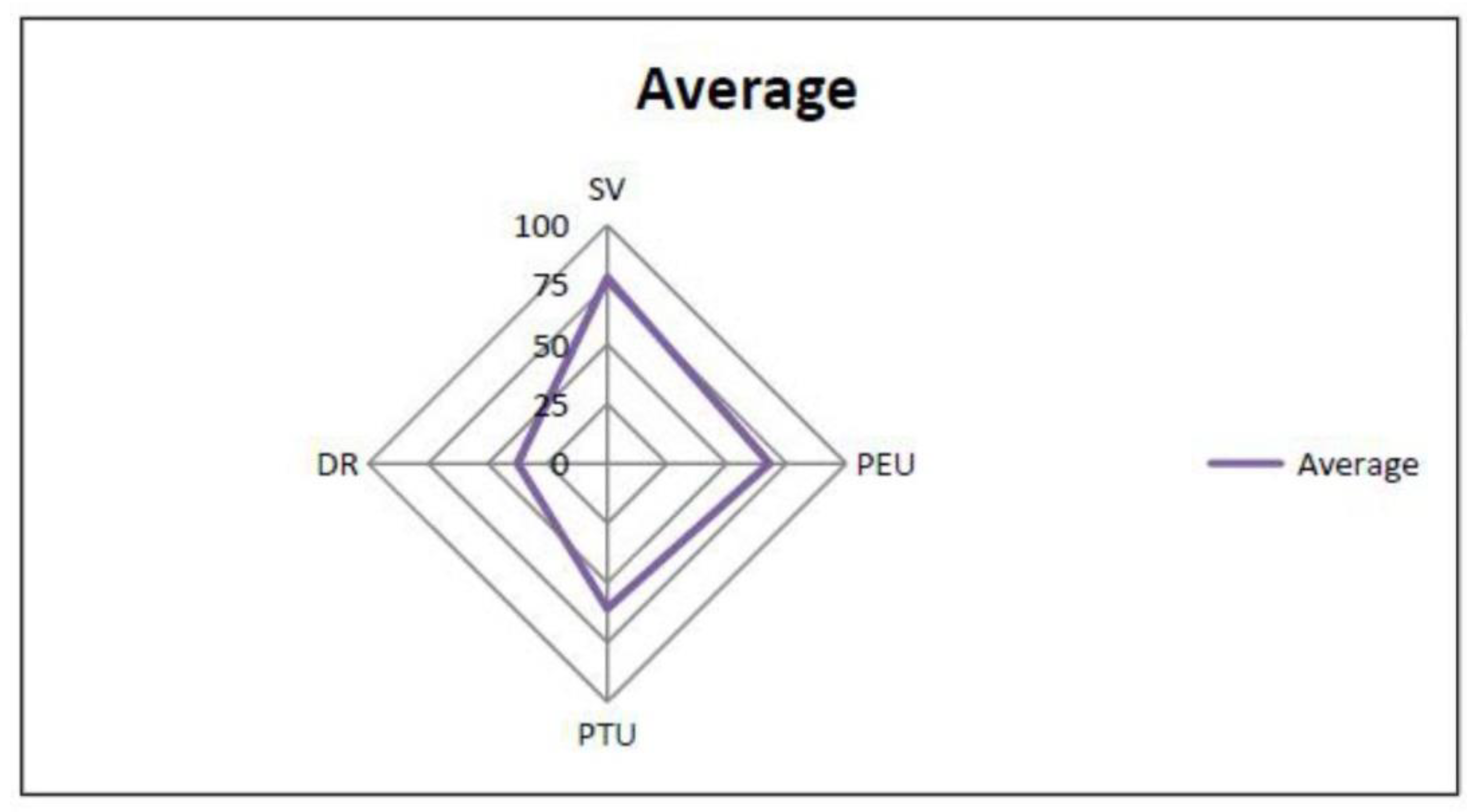
When considered as a georoute (
Figure 14), the Cenozoic Malaguide Basin of the Sierra Espuña area yields an SV average close to 80 (“very high”), a PEU close to 70 (“high”), a PTU close to 60 (“high”) and a DR lower to 30 (“moderate”). These values can give an idea of the importance of the basin; moreover, taking into account that the study area belongs to the Internal Zone. Due to this, the scoring of the criteria Rarity (Ra) and Uniqueness (U) are high since in this tectonic domain sedimentary outcropping is very scarce and only restricted to the Malaguide Complex.
8. Conclusions
The area of Sierra Espuña (Internal Betic Zone, S Spain) due to the quality of outcrops, areal representation, and continuity in the sedimentation can be considered a key area for the study of the Cenozoic Malaguide Basin.
This basin evolved from passive margin to wedge-top basin and sedimentation changed from limestone platforms with scarce terrigenous inputs to the deep basin with huge terrigenous supply.
The Cenozoic tectono-sedimentary basin evolution is related to three phases: (1) flexural tectonics during most of the Paleogene times to create the basin; (2) fault and fold compartmentation of the basin with the creation of structural highs and subsiding areas related to blind-fault-propagation folds, deforming the basin from south to north during Late Oligocene to Early Aquitanian times; (3) thin-skin thrusting tectonics during the Late Aquitanian-Burdigalian.
Eight key-outcrops have been selected as sites of geological interest to follow the tectono-sedimentary evolution of the Cenozoic basin from this area: Cretaceous-Cenozoic boundary, Paleocene Mula Fm, Lower Eocene Espuña-Valdelaparra Fms, Middle Eocene Malvariche-Cánovas Fms, Lowermost Oligocene As Fm, Upper Oligocene-Lower Aquitanian Bosque Fm, Upper Oligocene-Aquitanian Río Pliego Fm, Burdigalian El Niño Fm.
An evaluation has been performed to obtain four parameters: the scientific value, the educational and touristic potential, and the degradation risk.
The first three parameters obtained values above 50 being considered of “high” or “very high” interest (“very high” in most of the cases). The last parameter shows always values below 50 indicating a “moderate” or “low” risk of degradation.
When all sites are considered as a georoute, this area yields an SV average value close to 80 (“very high”), a PEU close to 70 (“high”), a PTU close to 60 (“high”), and a DR lower to 30 (“moderate”). The obtained values allow us considering the tectono-sedimentary evolution of this basin worthy of being proposed as a geological heritage.
9. Final Recommendations
Some recommendations can be done for the proposed sites of the Cenozoic Malaguide Basin from Sierra Espuña according to the valuation outlined above. In the case of SV, PEU, and PTU only “high” and “very high” values are obtained. These values indicate that the sites are potential of interest for the respective scientific community, educational or touristic purposes. We proposed the introducing of signaling, distributing guides and brochures to visitors, and the promotion of visits to the area as it has been also recommended by several authors [
33,
34,
35]. In the case of the DR thresholds that are “low” or “moderate” it only requires introducing regulatory measures in the sites with a “moderate” threshold.
Our evaluation of the sites demonstrates that there is significant potential for further geological studies by the scientific community. The sites also have great educational value for use in visits for high school and university students from the region. The sites have a moderate-high value for tourists interested in nature. The moderate degradation value accommodates these uses and enjoyment and only some indications and warnings for the visitor at the sites are required to ensure proper conservation.


 ,
, 


