
When Individual Geosites Matter Less—Challenges to Communicate Landscape Evolution of a Complex Morphostructure (Orlické–Bystrzyckie Mountains Block, Czechia/Poland, Central Europe)


Abstract
:1. Introduction
2. Study Area
2.1. Location and General Topography
2.2. Geology
2.3. Origin of the Orlické–Bystrzyckie Mountains Block Morphostructure—Patterns and Timeline
3. Materials and Methods
4. Geosites
5. Large-Scale Landforms—How to Show, Explain and Integrate into a Story?
5.1. The Role of Viewpoint Geosites
5.2. Opportunities from Remote Sources
5.3. The Contributing Role of Classic Geosites
6. Conclusions
Author Contributions
Funding
Data Availability Statement
Acknowledgments
Conflicts of Interest
References
- Reynard, E. Geosite. In Encyclopedia of Geomorphology; Goudie, A.S., Ed.; Routledge: London, UK, 2004; Volume 1, p. 440. [Google Scholar]
- Reynard, E. Geomorphosites: Definition and characteristics. In Geomorphosites; Reynard, E., Coratza, P., Regolini-Bissig, G., Eds.; Dr. Friedrich Pfeil Verlag: Munich, Germany, 2009; pp. 9–20. [Google Scholar]
- Hose, T.A. Geotourism and interpretation. In Geotourism; Dowling, R., Newsome, D., Eds.; Elsevier Butterworth-Heinemann: Oxford, UK, 2005; pp. 221–241. [Google Scholar]
- Hose, T.A. 3G’s for modern geotourism. Geoheritage 2012, 4, 7–24. [Google Scholar] [CrossRef]
- Dowling, R.K.; Newsome, D. Geotourism’s issues and challenges. In Geotourism; Dowling, R., Newsome, D., Eds.; Elsevier Butterworth-Heinemann: Oxford, UK, 2005; pp. 242–254. [Google Scholar]
- Dowling, R.K. Geotourism’s global growth. Geoheritage 2011, 3, 1–13. [Google Scholar] [CrossRef]
- Hughes, K.; Ballantyne, R. Interpretation rocks! Designing signs for geotourism sites. In Geotourism: The Tourism of Geology and Landscape; Newsome, D., Dowling, R.K., Eds.; Goodfellow: Oxford, UK, 2010; pp. 184–199. [Google Scholar]
- Bruno, B.C.; Wallace, A. Interpretative panels for geoheritage sites: Guidelines for design and evaluation. Geoheritage 2019, 11, 1315–1323. [Google Scholar] [CrossRef]
- Armiero, V.; Petrosino, P.; Lirer, L.; Alberico, I. The GeoCaF project: Proposal of a geosites network at Campi Flegrei (Southern Italy). Geoheritage 2011, 3, 195–219. [Google Scholar] [CrossRef] [Green Version]
- Lozar, F.; Clari, P.; Dela Pierre, F.; Natalicchio, M.; Berbardi, E.; Violanti, D.; Costa, M.; Giardino, M. Virtual tour of past environmental and climate change: The Messinian succession of the Tertiary Piedmont Basin (Italy). Geoheritage 2014, 7, 47–56. [Google Scholar] [CrossRef]
- Abratis, M.; Viereck, L.; Buchner, J.; Tietz, O. Route to the Volcanoes in Germany—Conceptual model for a geotourism project interconnecting geosites of Cenozoic volcanism. Z. Dtsch. Ges. Geowiss. 2015, 166, 161–185. [Google Scholar] [CrossRef]
- Aldighieri, B.; Testa, B.; Bertini, A. 3D Exploration of the San Lucano Valley: Virtual geo-routes for everyone who would like to understand the landscape of the Dolomites. Geoheritage 2016, 8, 77–90. [Google Scholar] [CrossRef]
- Pica, A.; Reynard, E.; Grangier, L.; Kaiser, C.; Ghiraldi, L.; Perotti, L.; Del Monte, M. GeoGuides, Urban geotourism offer powered by mobile application technology. Geoheritage 2017, 10, 311–326. [Google Scholar] [CrossRef]
- Migoń, P.; Duszyński, F.; Jancewicz, K.; Różycka, M. From plateau to plain—Using ergodic assumption in interpreting geoheritage through a thematic trail, Elbsandsteingebirge, Germany. Geoheritage 2019, 11, 839–855. [Google Scholar] [CrossRef] [Green Version]
- Wrede, V.; Mügge-Bartolović, V. GeoRoute Ruhr—A network of geotrails in the Ruhr Area National GeoPark, Germany. Geoheritage 2012, 4, 109–114. [Google Scholar] [CrossRef]
- Palladino, G.; Prosser, G.; Bentivenga, M. The geological itinerary of Sasso di Castalda: A journey into the geological history of the Southern Apennine Thrust-belt (Basilicata, Southern Italy). Geoheritage 2013, 5, 47–58. [Google Scholar] [CrossRef]
- Santangelo, N.; Romano, P.; Santo, A. Geo-itineraries in the Cilento Vallo di Diano Geopark: A tool for tourism development in southern Italy. Geoheritage 2015, 7, 319–335. [Google Scholar] [CrossRef]
- Migoń, P.; Pijet-Migoń, E. Viewpoint geosites—Values, conservation and management issues. Proc. Geol. Assoc. 2017, 128, 511–522. [Google Scholar] [CrossRef]
- Mikhailenko, A.V.; Ruban, D.A.; Yashalova, N.N.; Rebezov, M.B. The unique granite gorge in Mountainous Adygeya, Russia: Evidence of big and complex geosite disproportions. Geosciences 2019, 9, 372. [Google Scholar] [CrossRef] [Green Version]
- Migoń, P.; Latocha, A. Human interactions with the sandstone landscape of Central Sudetes. Appl. Geogr. 2013, 42, 206–216. [Google Scholar] [CrossRef]
- Migoń, P. Rediscovering geoheritage, reinventing geotourism—200 years of experience from the Sudetes, Central Europe. In Appreciating Physical Landscapes; Special Publication; Hose, T.A., Ed.; Geological Society of London: London, UK, 2016; Volume 417, pp. 215–228. [Google Scholar]
- Vítek, J. Adršpach-teplice rocks and broumov cliffs—Large sandstone rock cities in the Central Europe. In Landscapes and Landforms of the Czech Republic; Pánek, T., Hrádecký, J., Eds.; Springer: Cham, Switzerland, 2016; pp. 209–220. [Google Scholar]
- Ziegler, P.A.; Dèzes, P. Cenozoic uplift of Variscan Massifs in the Alpine foreland: Timing and controlling mechanisms. Glob. Planet. Chang. 2007, 5, 237–269. [Google Scholar] [CrossRef]
- Opletal, M.; Domečka, K.; Čech, S.; Čuta, M.; Fajst, M.; Holub, V.; Kačura, G.; Líbalová, J.; Pošmourný, K.; Sekyra, J.; et al. Geologie Orlických Hor; Ústřední Ústav Geologický: Prague, Czechoslovakia, 1980. [Google Scholar]
- Żelaźniewicz, A.; Jastrzębski, M.; Redlińska-Marczyńska, A.; Szczepański, J. The Orlica-Śnieżnik Dome, the Sudetes, in 2002 and 12 years later. Geol. Sudetica 2014, 42, 105–123. [Google Scholar]
- Cymerman, Z. Kopuła orlicko-śnieżnicka w świetle rozważań tektonicznych. Przegląd Geologiczny 2016, 64, 814–830. [Google Scholar]
- Wojewoda, J. Perm basenu Nachodu. Sedimentologica 2007, 1, 85–99. [Google Scholar]
- Prosová, M. Fossil weathering products in the foothills of the West-Sudeten. Acta Univ. Carol. Geol. 1973, 3, 213–226. [Google Scholar]
- Prosová, M. Geneze Reliktního Terciéru; Univerzita Karlova: Prague, Czechoslovakia, 1974. [Google Scholar]
- Sroka, W. Ewolucja morfotektoniczna Sudetów w rejonie Kotliny Kłodzkiej w świetle analizy morfometryczno-statystycznej. Acta Univ. Wratisl. 1997, 1939, 57. [Google Scholar]
- Ranoszek, W. Morfologia progów tektonicznych obramowujących Rów Górnej Nysy. Acta Univ. Wratisl. 1998, 2061, 23–35. [Google Scholar]
- Šebesta, D. Porovnání geomorfologických pomĕrů povodí Zdobnice a Bĕlé. Východočeský Sborník Přírodovědný Práce Stud. 2000, 8, 3–29. [Google Scholar]
- Latocha, A. Uwarunkowania rozwoju rzeźby struktur płytowych na przykładzie Gór Stołowych i Gór Bystrzyckich. Przegląd Geogr. 2003, 75, 231–250. [Google Scholar]
- Šebesta, D. Geomorfologické pomĕry povodí Olešenky. Východočeský Sborník Přírodovědný Práce Stud. 2005, 12, 15–28. [Google Scholar]
- Różycka, M.; Migoń, P. Geomorphometry and statistics-based approach for recognition of areas of enhanced erosion and their morphotectonic interpretation. In Proceedings of the Geomorphometry 2020 Conference, Perugia, Italy, 22–26 June 2020; Alvioli, M., Marchesini, I., Melelli, L., Guth, P., Eds.; pp. 151–154. [Google Scholar]
- Różycka, M. Morphostructure of the Bystrzyckie-Orlickie Mountains Block in the Middle Sudetes in the Light of Quantitative Analysis of Relief. Ph.D. Thesis, University of Wrocław, Wroclaw, Poland, January 2020. [Google Scholar]
- Malkovský, M.; Benešová, Z.; Čadek, J.; Holub, V.; Chaloupský, J.; Jetel, J.; Müller, V.; Mašín, J.; Tásler, R. Geologie České Křídové Pánve a Jejího Podloží; Ústředni Ústav Geologický, Československé Akademie Věd: Prague, Czechoslovakia, 1974. [Google Scholar]
- Skoček, V.; Valečka, J. Palaeogeography of the Late Cretaceous Quadersandstein of Central Europe. Palaeogeogr. Palaeoclimatol. Palaeoecol. 1983, 44, 71–92. [Google Scholar] [CrossRef]
- Gierwielaniec, J.; Turnau-Morawska, M. Geneza glaukonitu przy transgresji morza kredowego na krystalinik na obszarze między Kudową a Spaloną. Arch. Miner. 1965, 25, 261–275. [Google Scholar]
- Coubal, M.; Málek, J.; Adamovič, J.; Štěpančíková, P. Late Cretaceous and Cenozoic dynamics of the Bohemian Massif inferred from the paleostress history of the Lusatian Fault belt. J. Geodyn. 2015, 87, 26–49. [Google Scholar] [CrossRef]
- Sobczyk, A.; Sobel, E.R.; Georgieva, V. Meso–Cenozoic cooling and exhumation history of the Orlica-Śnieżnik Dome (Sudetes, NE Bohemian Massif, Central Europe): Insights from apatite fission-track thermochronometry. Terra Nova 2020, 32, 122–133. [Google Scholar] [CrossRef]
- Kopecký, A. Hlavni rysy neotektoniky Československa. Sborník Geol. Věd 1972, A6, 77–155. [Google Scholar]
- Demek, J.; Kirchner, K.; Mackovčin, P.; Slavík, P. Morphostructures on the Territory of the Czech Republic (Europe). Z. Geomorphol. 2009, 53 (Suppl. 2), 1–10. [Google Scholar] [CrossRef]
- Ranoszek, W. Zastosowanie różnych metod morfometrycznych w analizie morfologii progu tektonicznego na przykładzie zachodniej krawędzi Masywu Śnieżnika. Przegląd Geol. 1999, 47, 1027–1031. [Google Scholar]
- Žatecká, P. Vývoj říčního systému v povodí nejhořejší Tiché Orlice. Orlické Hory Podorlicko 1996, 8, 17–24. [Google Scholar]
- Vaničkova, E. Geomorfologický vývoj Zemské brány v Orlických horách. Východočeský Sborník Přírodovědný Práce Stud. 2007, 14, 15–33. [Google Scholar]
- Różycka, M.; Michniewicz, A.; Migoń, P.; Kasprzak, M. Identification and morphometric properties of landslides in the Bystrzyckie Mountains (Sudetes, SW Poland) based on data derived from airborne LiDAR. In Geomorphometry for Geosciences; Jasiewicz, J., Zwoliński, Z., Mitasova, H., Hengl, T., Eds.; Adam Mickiewicz University in Poznań—Institute of Geoecology and Geoinformation, International Society for Geomorphometry: Poznan, Poland, 2015; pp. 247–250. [Google Scholar]
- Różycka, M.; Migoń, P.; Michniewicz, A. Topographic Wetness Index and Terrain Ruggedness Index in landslide studies, on examples from the Sudetes, SW Poland. Z. Geomorphol. 2017, 61 (Suppl. 2), 61–80. [Google Scholar] [CrossRef] [Green Version]
- Wężyk, P. (Ed.) Podręcznik dla Uczestników Szkoleń z Wykorzystaniem Produktów LiDAR: Informatyczny System Osłony Kraju Przed Nadzwyczajnymi Zagrożeniami; Główny Urząd Geodezji i Kartografii: Warsaw, Poland, 2015. [Google Scholar]
- Brázdil, K. Technická Zpráva k Digitálnímu Modelu Reliéfu 5: Generace DMR 5G; Zeměměřický Úřad, Vojenský Geografický a Hydrometeorologický Úřad: Prague, Czech Republic, 2016; Available online: http://geoportal.cuzk.cz/Dokumenty/TECHNICKA_ZPRAVA_DMR_5G.pdf (accessed on 22 August 2019).
- Instytut Geologiczny. Szczegółowa Mapa Geologiczna Sudetów 1:25 000; Sheets Bystrzyca Kłodzka, Bystrzyca Nowa, Domaszków, Duszniki-Zdrój, Jeleniów, Kłodzko, Krosnowice, Kudowa-Zdrój, Lesica, Lewin Kłodzki, Międzylesie, Mostowice, Poręba, Polanica-Zdrój, Szalejów Górny, Wambierzyce; Instytut Geologiczny: Warsaw, Poland, 1980. [Google Scholar]
- Geovědní Mapy 1:50 000. Available online: https://mapy.geology.cz/geocr50/ (accessed on 9 January 2021).
- Vítek, J. Krajinou Severovýchodních Čech: Hory, Kopce, Vyhlídková Místa, Údolí, Skály, Jeskyně; Oftis: Ústí nad Orlicí, Czech Republic, 2000. [Google Scholar]
- Stachowiak, A.; Cwojdziński, S.; Ihnatowicz, A.; Pacuła, J.; Mrázová, S.; Skácelová, D.; Otava, J.; Pecina, V.; Rejchrt, M.; Skácelová, Z.; et al. Geostrada Sudecka—Przewodnik Geologiczno-Turystyczny; PIG–PIB: Warsaw, Poland, 2013. [Google Scholar]
- Databáze Významných Geologických Lokalit, Praha: Česká Geologická Služba. 1998. Available online: http://lokality.geology.cz (accessed on 4 January 2021).
- Ruban, D.A. Quantification of geodiversity and its loss. Proc. Geol. Assoc. 2010, 121, 326–333. [Google Scholar] [CrossRef]
- Kotwicka, W.; Duszyński, F.; Jancewicz, K. Morfologia progu piaskowcowego na wschodnim stoku wzniesienia Bronisz w Górach Bystrzyckich. Przyr. Sudet. 2019, 22, 161–188. [Google Scholar]
- Migoń, P.; Różycka, M.; Jancewicz, K. Zespół osuwisk na Toczku (Góry Bystrzyckie) w świetle analizy geomorfometrycznej. Przyr. Sudet. 2016, 19, 167–188. [Google Scholar]
- Vítek, J. Geomorfologie novohrádeckého masívu. Práce Stud. 2013, 20, 3–22. [Google Scholar]
- Cayla, N.; Martin, S. Digital geovisualization technologies applied to geoheritage management. In Geoheritage, Assessment, Protection and Management; Reynard, E., Brilha, J., Eds.; Elsevier: Amsterdam, The Netherlands, 2018; pp. 289–303. [Google Scholar]
- Tooth, S. Google EarthTM in geomorphology: Re-enchanting, revolutionizing, or just another resource? In Treatise on Geomorphology; Shroder, J., Switzer, A.D., Kennedy, D.M., Eds.; Academic Press: San Diego, CA, USA, 2013; Volume 14, pp. 53–64. [Google Scholar]
- Mather, A.E.; Mills, S.; Stokes, M.; Fyfe, R. Ten years on: What can Google Earth offer the geoscience community? Geol. Today 2015, 31, 216–221. [Google Scholar] [CrossRef]
- Google Earth ProTM. Available online: https://earth.google.com/web/ (accessed on 11 January 2021).
- Geoportal Infrastruktury Infomacji Przestrzennej. Available online: http://geoportal.gov.pl (accessed on 23 January 2021).
- Aleš, M. Orlické Hory 1:75 000; Kartografie HP, s.r.o.: Jicin, Czech Republic, 2005. [Google Scholar]
- Hasiuk, F.J.; Harding, C.; Renner, A.R.; Winer, E. TouchTerrain: A simple web-tool for creating 3D-printable topographic models. Comp. Geosci. 2017, 109, 25–31. [Google Scholar] [CrossRef]


| Number of Geosite (See Figure 1 and Figure 2) | Specific Name (If Applicable) or Name of Nearest Settlement (in Brackets) | Content | Type of Geosite—Main Theme | Remarks |
|---|---|---|---|---|
| 1 | (Běloves) | Conglomerate crags | Geology–lithology | Protected site |
| 2 | (Běloves) | Abandoned rhyolite quarry | Geology–lithology | - |
| 3 | Peklo | River gorge | Geomorphology | Protected area |
| 4 | (Nový Hrádek) | Abandoned granodiorite quarry | Geology–lithology | - |
| 5 | (Nový Hrádek) | Abandoned phyllite quarry | Geology–lithology | - |
| 6 | (Nové Město nad Metuji) | Natural outcrops of Cretaceous sediments over basement | Geology–lithology | - |
| 7 | Špičák | Abandoned gabbrodiorite quarry | Geology–lithology | - |
| 8 | Jelení lazeň | Peat bog | Geomorphology | Protected area |
| 9 | Marušin kámen | Gneissic crag | Geomorphology | - |
| 10 | Sfinga | Schist crag | Geomorphology | Protected site |
| 11 | (Mnichová) | Amphibolite outcrops in road cut | Geology–lithology | - |
| 12 | (Masty) | Working amphibolite quarry | Geology–lithology | Not accessible without permission |
| 13 | (Bílý Ujezd) | Natural outcrops of Cretaceous sediments over basement | Geology–lithology | - |
| 14 | Růženina Hut’ | Abandoned amphibolite quarry | Geology–lithology | - |
| 15 | (Kačerov) | Mica schist crag | Geomorphology | - |
| 16 | (Zdobnička) | Abandoned gneiss quarry with lamprophyre dykes | Geology–lithology | - |
| 17 | Na Dolech | Ancient mining works | Mining history | - |
| 18 | U Kunštatské kaple | Peat bog | Geomorphology | Protected area |
| 19 | (Lukavice) | Man-made outcrops of weathered rocks (laterite) | Geology–lithology | Inaccessible underground galleries |
| 20 | (Pěčin) | Abandoned gabbrodiorite quarry | Geology–lithology | - |
| 21 | (Nebeská Rybna) | Trachyte outcrops in road cut | Geology–lithology | - |
| 22 | Myší díra | Natural outcrops of serpentinite | Geology–lithology | - |
| 23 | (Bartošovice v Orlických horach) | Abandoned sand pit in Cretaceous sediments | Geology–lithology | - |
| 24 | Zemská brána | River gorge | Geomorphology | Protected area |
| 25 | Studenské skály | Gneissic crags | Geomorphology | - |
| 26 | Udolí Orličky | Natural gneiss outcrops | Geology–lithology | - |
| 27 | Čenkovička | Natural gneiss outcrops | Geology–lithology | Protected area |
| Number of Geosite (See Figure 1 and Figure 2) | Specific Name (If Applicable) or Name of Nearest Settlement (in Brackets) | Content | Type of Geosite—Main Theme | Remarks |
|---|---|---|---|---|
| 28 | Duszniki-Zdrój | Mineral springs in spa park | Hydrogeology | - |
| 29 | (Duszniki-Zdrój) | Mylonite outcrop | Geology–lithology | - |
| 30 | Kozia Hala | Abandoned marble quarry | Geology–lithology | - |
| 31 | (Zieleniec) | Abandoned dolomite quarry | Geology–lithology | - |
| 32 | Złota Sztolnia | Ancient mining works | Mining history | Not accessible |
| 33 | (Zieleniec) | Mica schist outcrop | Geology–lithology | - |
| 34 | Torfowisko pod Zieleńcem | Peat bog | Geomorphology | Limited accessibility—nature reserve |
| 35 | Siwa Skała | Gneissic crag | Geomorphology | - |
| 36 | (Spalona) | Abandoned gneiss quarry | Geology–lithology | - |
| 37 | Szary Kamień | Gneissic crag | Geomorphology | - |
| 38 | (Młoty) | Sandstone blockfields | Geomorphology | - |
| 39 | (Młoty) | Gneiss outcrop in disused gallery for power station | Geology–lithology | Not accessible |
| 40 | (Wójtowice) | Gneiss outcrop | Geology–lithology | - |
| 41 | (Poręba) | Gneiss outcrops in road cut | Geology–lithology | - |
| 42 | (Poręba) | Mica schist outcrop in road cut | Geology–lithology | - |
| 43 | (Rudawa) | Gneiss outcrop in road cut | Geology–lithology | - |
| 44 | Jedlnik | Viewing point | Geomorphology | - |
| 45 | Szczerba | Castle ruins—amphibolite as building stone | Geology–lithology | - |
| 46 | Solna Jama | Karstic cave | Geomorphology | - |
| 47 | Różanka | Sandstone sculptures next to church | Use of rock resources | - |
| 48 | (Różanka) | Abandoned marl and sandstone quarry | Geology–lithology | - |
| 49 | (Długopole-Zdrój) | Working sandstone quarry | Geology–lithology | Not accessible without permission |
| 50 | Długopole-Zdrój | Mineral springs in spa park | Hydrogeology | - |
| Principal Theme | Number of Geosites | |||
|---|---|---|---|---|
| Czechia | Poland | Total | ||
| Absolute | Percentage | |||
| Geology—lithology | 18 | 13 | 31 | 62 |
| Geomorphology | 8 | 6 | 14 | 28 |
| Mining history | 1 | 1 | 2 | 4 |
| Hydrogeology | - | 2 | 2 | 4 |
| Use of geological resources | - | 1 | 1 | 2 |
| Total | 27 | 23 | 50 | 100 |
| Letter Code | Locality | Type of Viewpoint | Brief Description of View | |
|---|---|---|---|---|
| Foreground | Background | |||
| Western Part | ||||
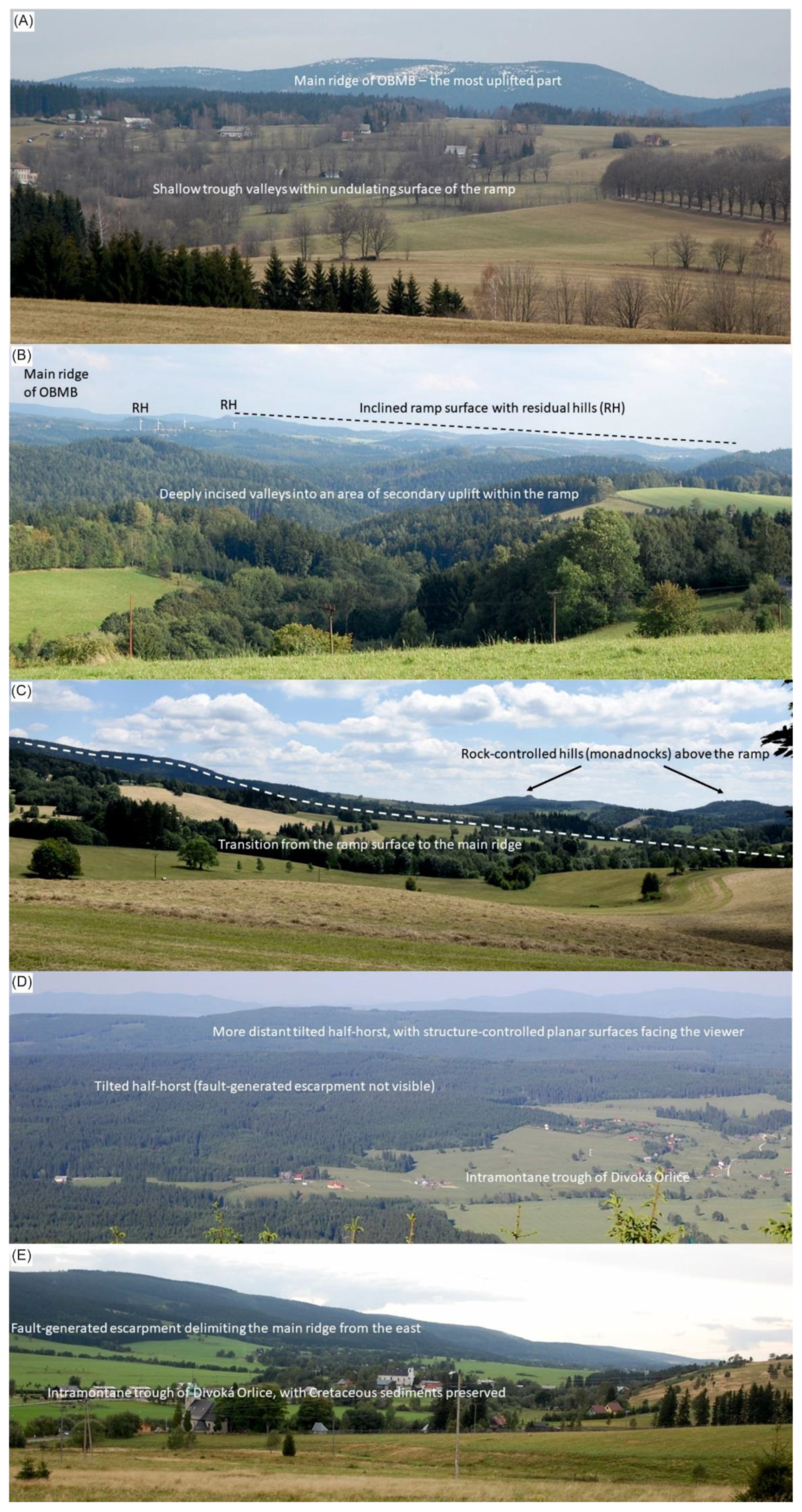
| A | Liberk | Open terrain | Shallow trough valleys within undulating surface of the ramp | Main ridge of the Orlické–Bystrzyckie Mountains Block (OBMB)—the most uplifted part |
| B | Dobrošov | Viewing tower | Deeply incised valleys into an area of secondary uplift within the ramp | Inclined ramp surface with residual hills; main ridge of OBMB in the far left |
| C | Polom | Open terrain | Transition from the ramp surface to the main ridge—evidence of increasing uplift | Rock-controlled hills (monadnocks) rising above the ramp |
| Axial Part | ||||
| D | Velká Deštná | Viewing tower | Tilted half-horst (fault-generated escarpment not visible) and intramontane trough of Divoká Orlice | More distant tilted half-horst, with structure-controlled planar surfaces facing the viewer |
| E | Mostowice | Open terrain | Intramontane trough of Divoká Orlice, with Cretaceous sediments preserved | Fault-generated escarpment delimiting the main ridge of OBMB from the east |
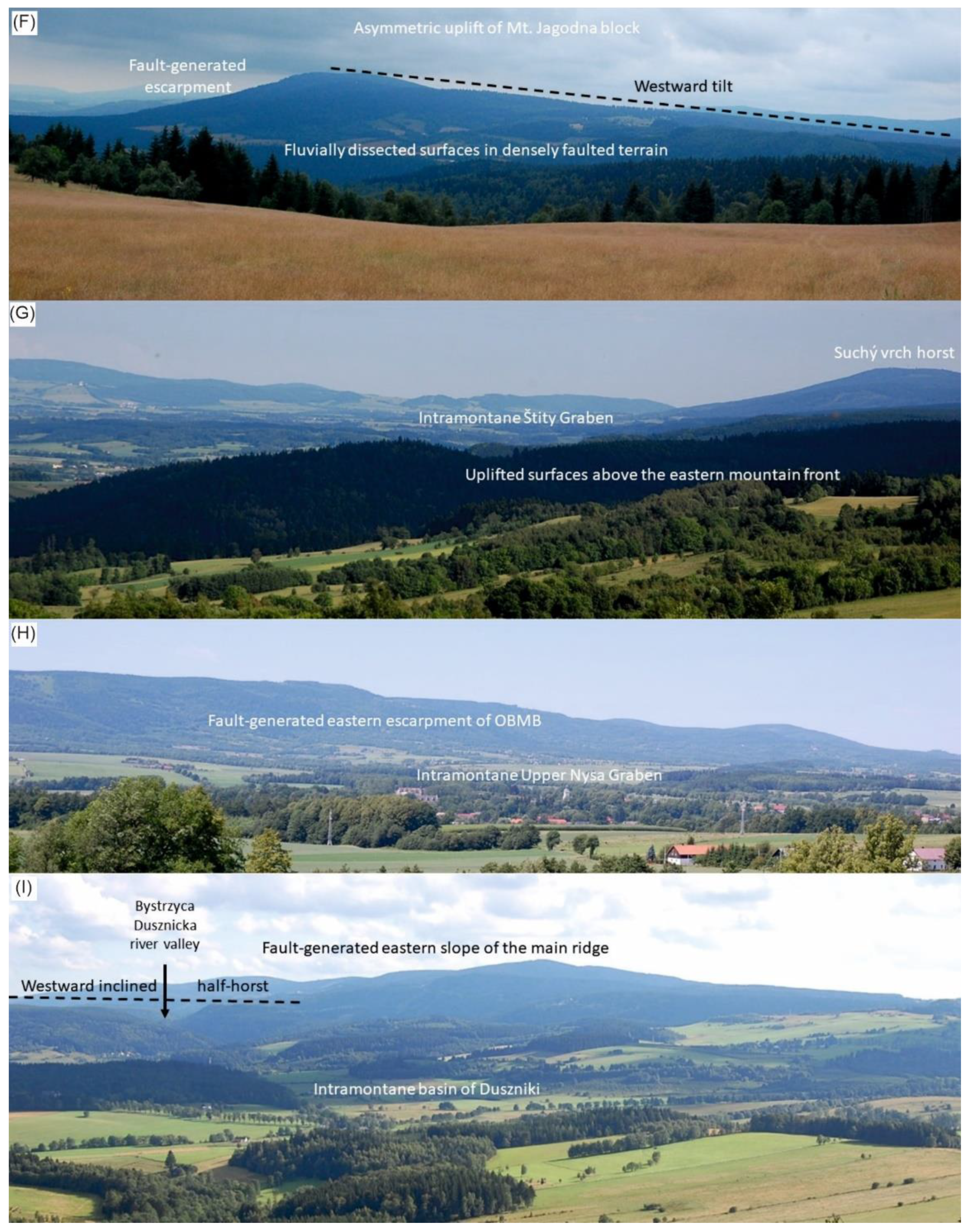
| Not coded | Suchý vrch | Viewing tower | Axial part of the main ridge (southernmost part) | Asymmetric uplift of Suchý vrch block, fault-generated escarpment in the east (left), westward tilt |
| Eastern Part | ||||
| F | Huta | Open terrain | Fluvially dissected surfaces in densely faulted terrain | Asymmetric uplift of Mt. Jagodna block, fault-generated escarpment in the east (left), westward tilt |
| G | Jedlnik | Open terrain | Uplifted surfaces above the eastern mountain front | Intramontane Štity Graben (middle) and Suchý vrch horst (right) |
| H | Mielnik * | Open terrain | Intramontane Upper Nysa Graben | Fault-generated eastern escarpment of OBMB |
| Northern Part | ||||
| I | Skały Puchacza * | Open terrain | Northern foreland of OBMB (intramontane basin of Duszniki) | Westward inclined half-horst, incised by Bystrzyca Dusznicka river, with structure-controlled planar surfaces (left), and fault-generated eastern slope of the main ridge. |
Publisher’s Note: MDPI stays neutral with regard to jurisdictional claims in published maps and institutional affiliations. |
© 2021 by the authors. Licensee MDPI, Basel, Switzerland. This article is an open access article distributed under the terms and conditions of the Creative Commons Attribution (CC BY) license (http://creativecommons.org/licenses/by/4.0/).
Share and Cite
Migoń, P.; Różycka, M. When Individual Geosites Matter Less—Challenges to Communicate Landscape Evolution of a Complex Morphostructure (Orlické–Bystrzyckie Mountains Block, Czechia/Poland, Central Europe). Geosciences 2021, 11, 100. https://0-doi-org.brum.beds.ac.uk/10.3390/geosciences11020100
Migoń P, Różycka M. When Individual Geosites Matter Less—Challenges to Communicate Landscape Evolution of a Complex Morphostructure (Orlické–Bystrzyckie Mountains Block, Czechia/Poland, Central Europe). Geosciences. 2021; 11(2):100. https://0-doi-org.brum.beds.ac.uk/10.3390/geosciences11020100
Chicago/Turabian StyleMigoń, Piotr, and Milena Różycka. 2021. "When Individual Geosites Matter Less—Challenges to Communicate Landscape Evolution of a Complex Morphostructure (Orlické–Bystrzyckie Mountains Block, Czechia/Poland, Central Europe)" Geosciences 11, no. 2: 100. https://0-doi-org.brum.beds.ac.uk/10.3390/geosciences11020100