
Inverted Basins by Africa–Eurasia Convergence at the Southern Back-Arc Tyrrhenian Basin

 ,
, 
Abstract
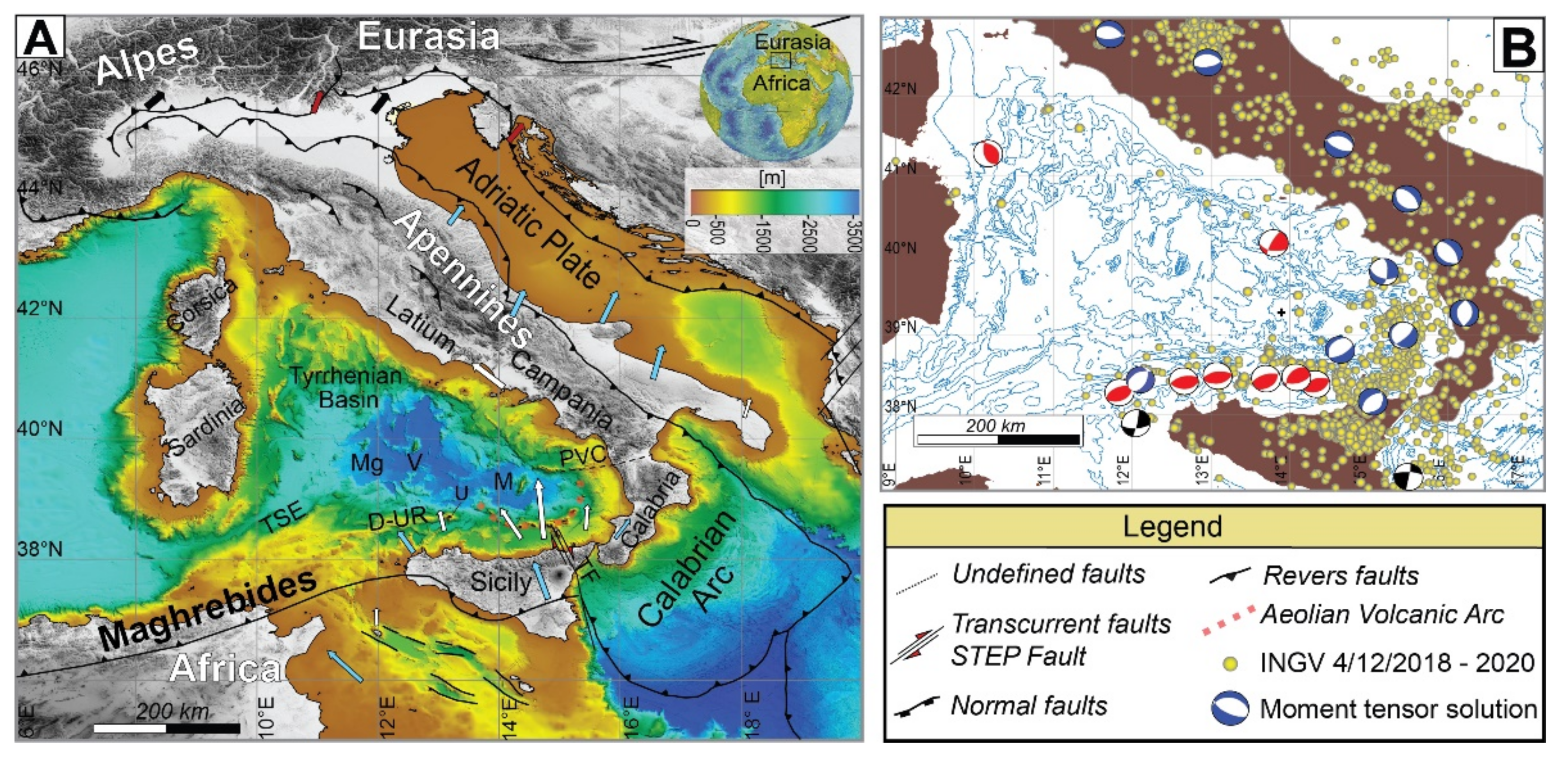
:1. Introduction

2. Materials and Methods
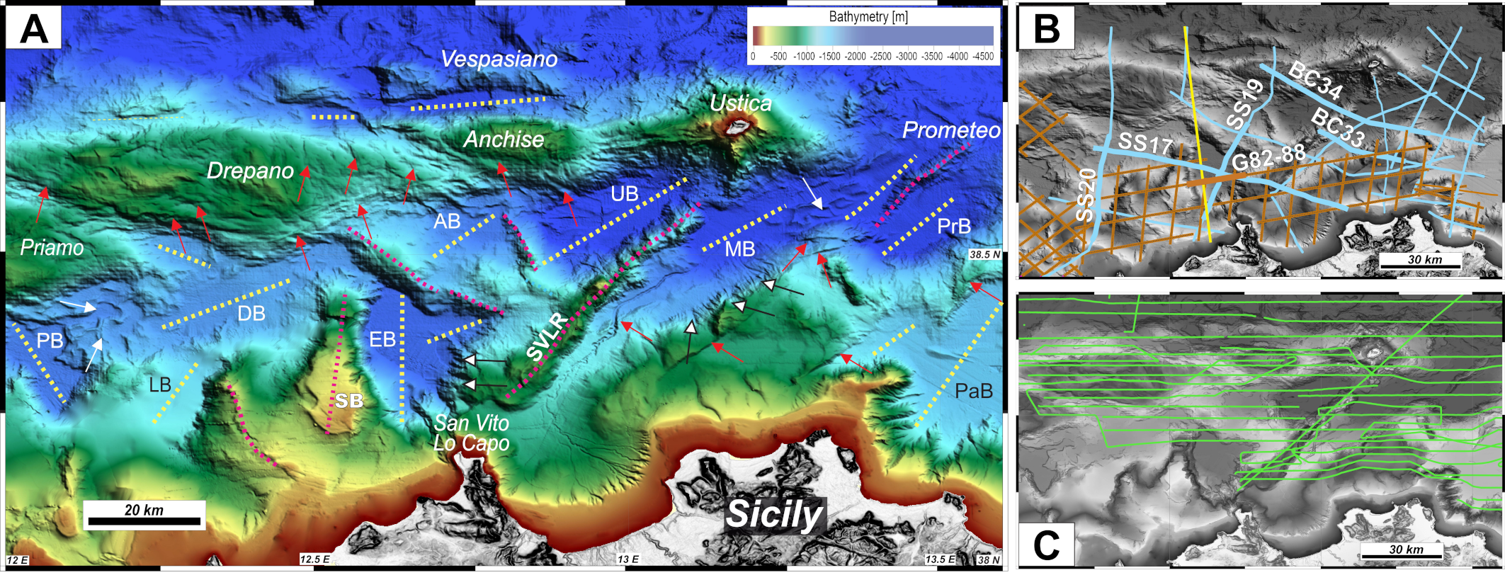
2.1. Morpho-Bathymetry
2.2. Seismic Profiles
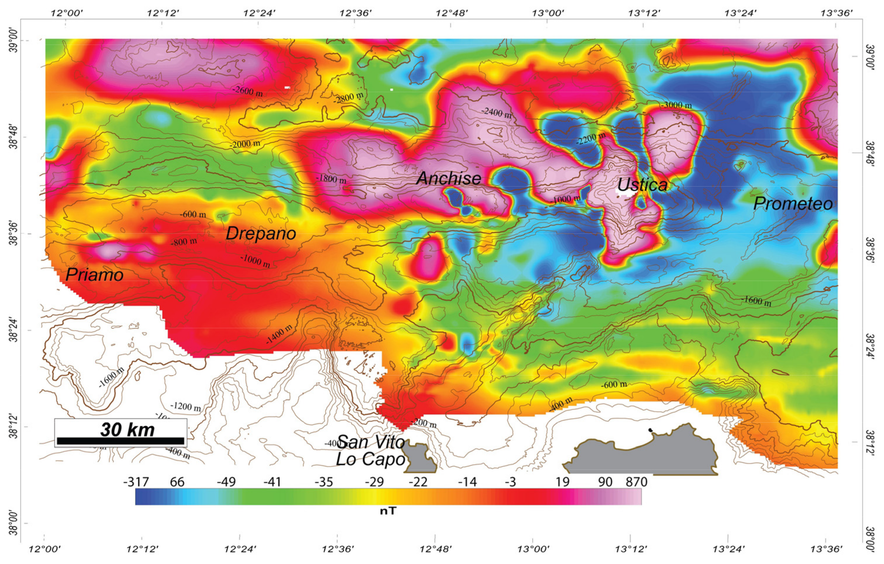
2.3. Magnetic Data
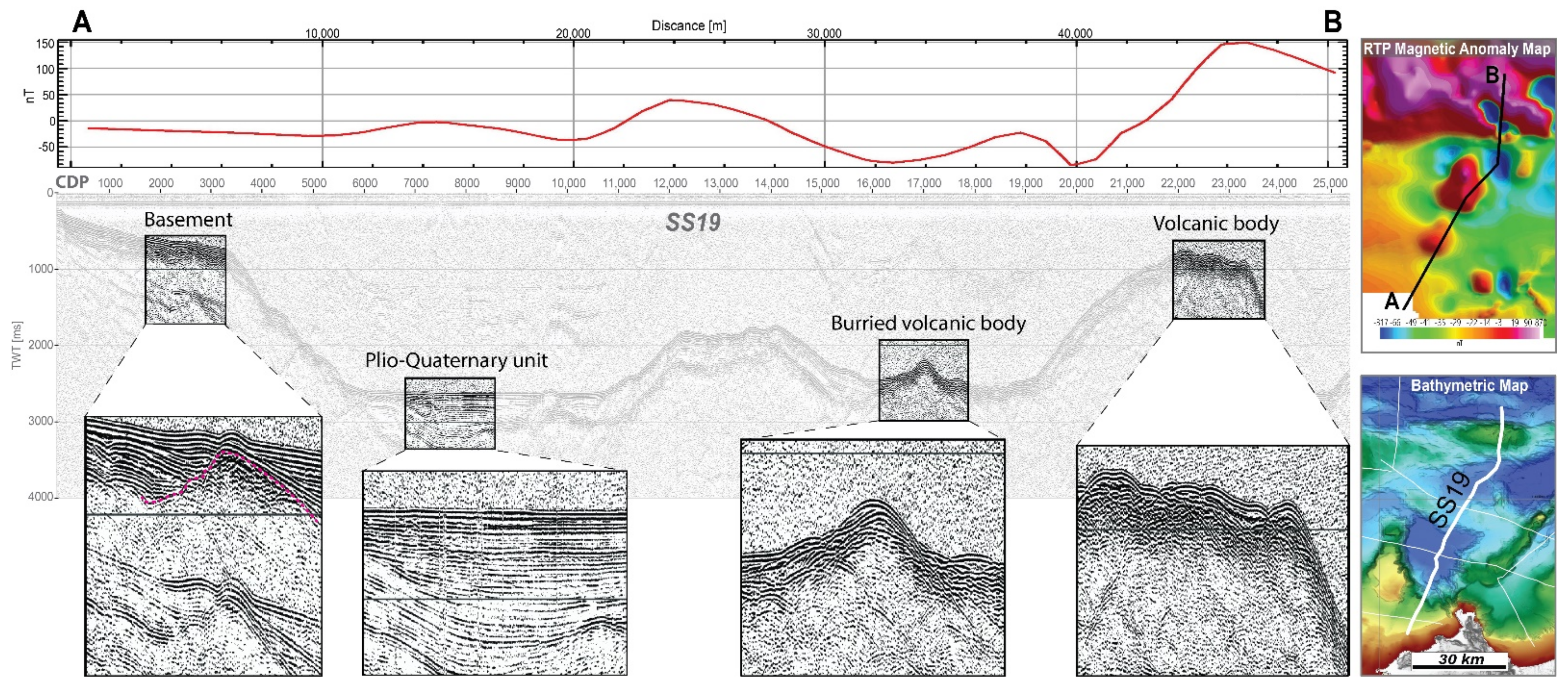
2.4. Seismostratigraphy
3. Results
3.1. Magnetic Anomalies
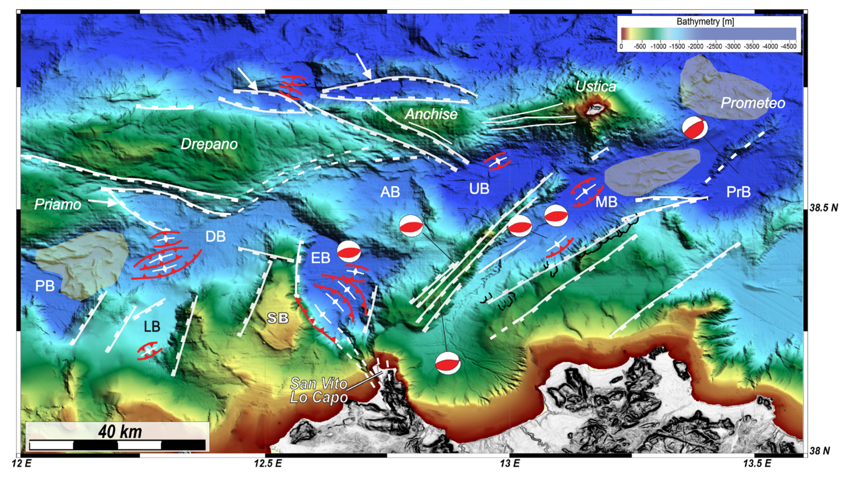
3.2. Morpho-Bathymetry
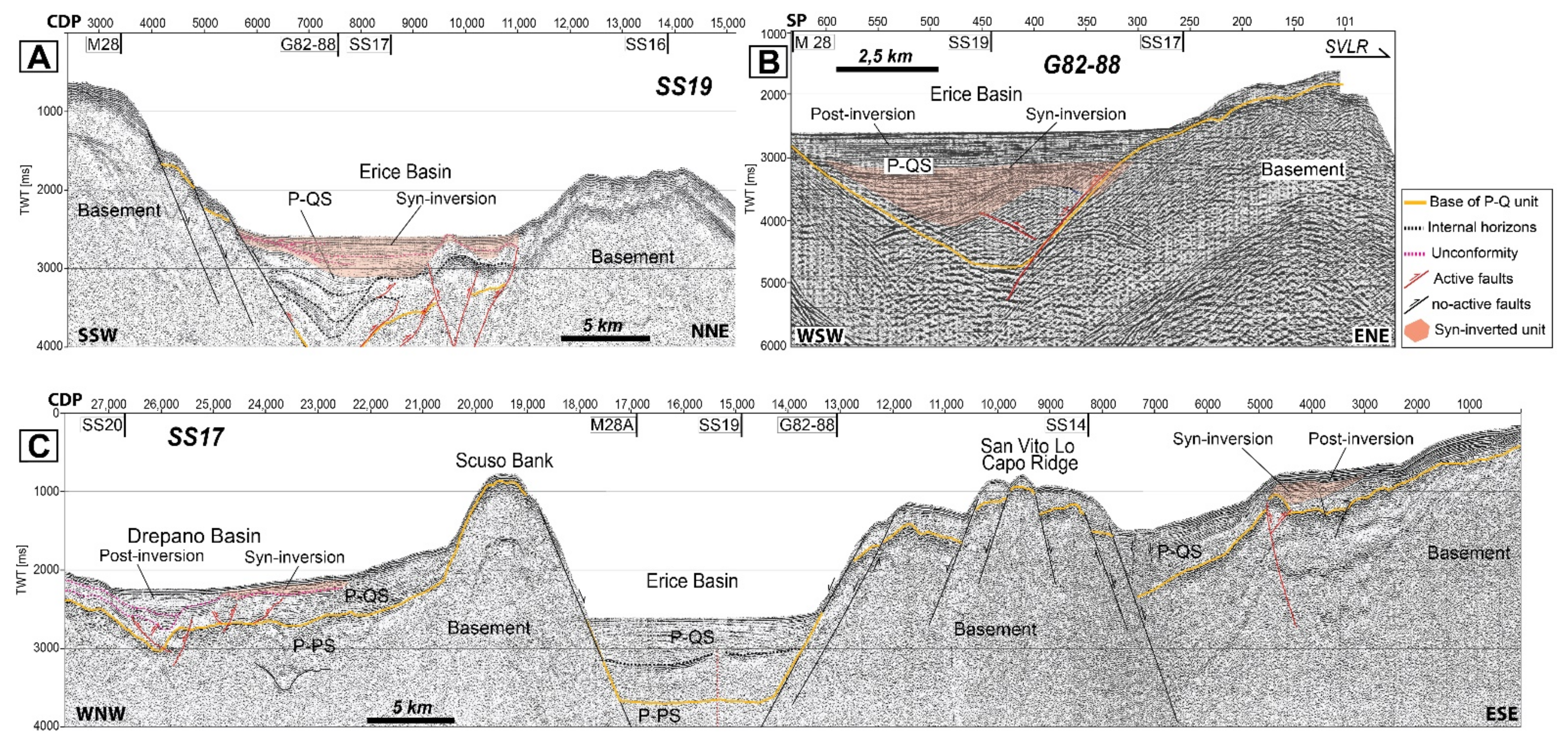
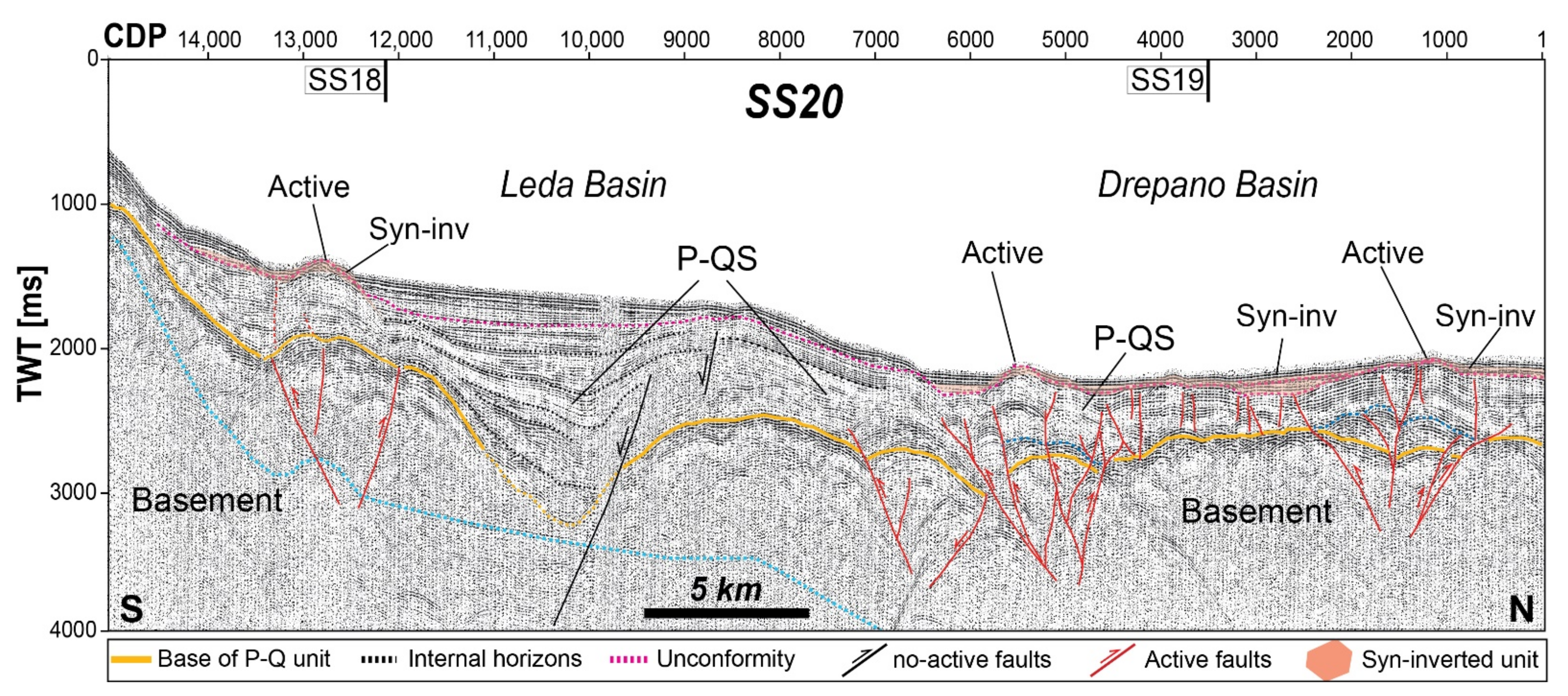
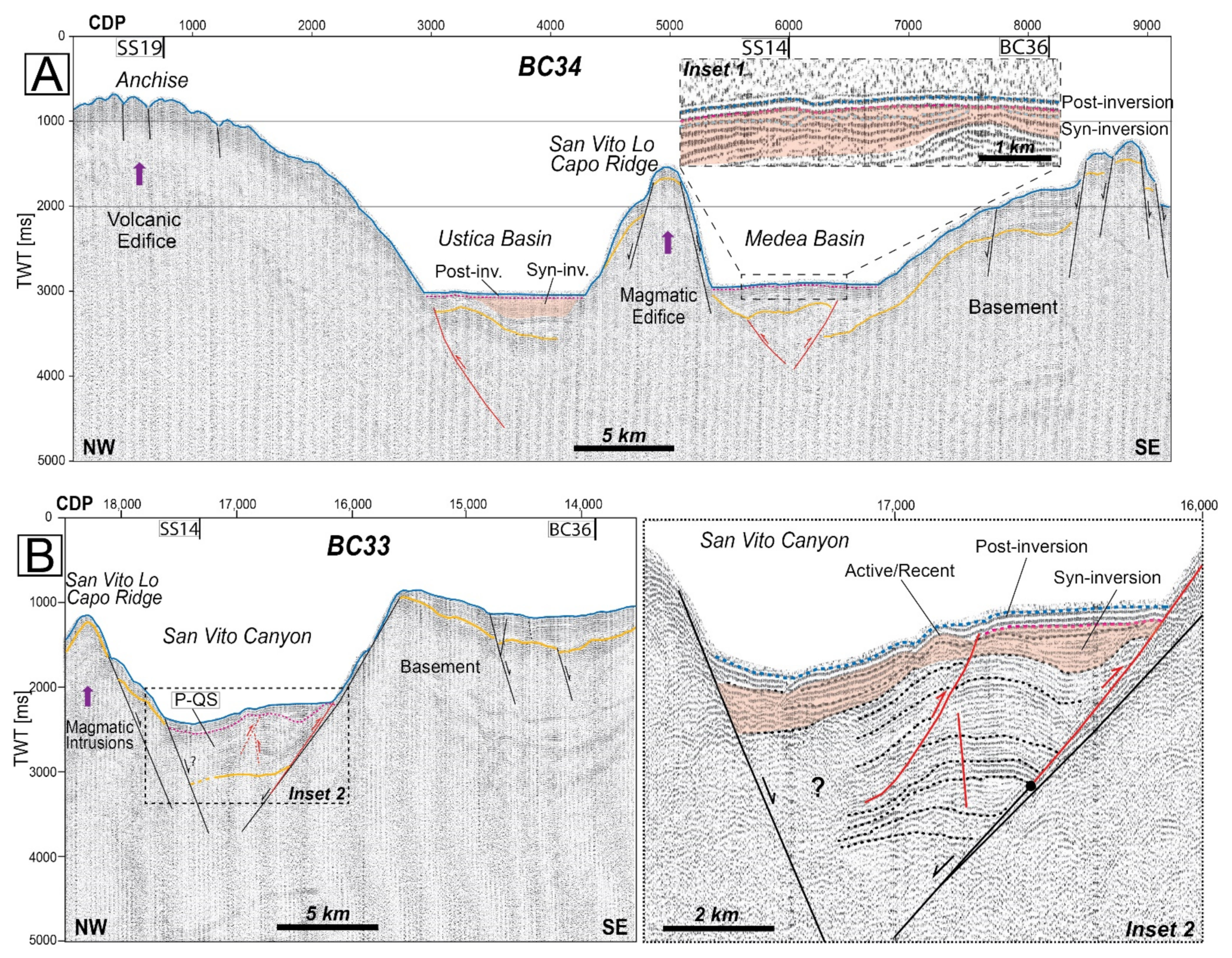
3.3. Seismic Profiles
3.4. Structural and Sedimentary Thickness Map
4. Discussion
4.1. Basin Opening in Pliocene Time
4.2. Basin Inversion in Quaternary Time
5. Conclusions
Author Contributions
Funding
Data Availability Statement
Acknowledgments
Conflicts of Interest
References
- Uyeda, S.; Kanamori, H. Back-arc opening and the mode of subduction. J. Geophys. Res. 1979, 84, 1049–1061. [Google Scholar] [CrossRef] [Green Version]
- Bernoulli, D.; Davies, G.A.; Montadert, L. Listric Normal Faults. In Proceedings of the 26th International Geological Congress, Paris, France, 7 July 1980. [Google Scholar]
- Boillot, G.; Recq, M.; Winterer, E.L.; Meyer, A.W.; Applegate, J.; Baltuck, M.; Williamson, M. Tectonic denudation of the upper mantle along passive margins: A model based on drilling results (ODP leg 103, western Galicia margin, Spain). Tectonophysics 1987, 132, 335–342. [Google Scholar] [CrossRef]
- Florineth, D. Transition from continental to oceanic basement in the Tansa nappe (Engadine window, Grarunden, Switzerland): Evidence for Early Cretaceous opening of the Valais ocean. Schwiz Mineral Petrogr. Mitt. 1994, 74, 348–437. [Google Scholar]
- O’Brien, P.J. Subduction followed by collision: Alpine and Himalayan examples. Phys. Earth Planet. Inter. 2001, 127, 277–291. [Google Scholar] [CrossRef]
- Horváth, F.; Bada, G.; Szafián, P.; Tari, G.; Ádám, A.; Cloetingh, S. Formation and deformation of the Pannonian Basin: Constraints from observational data. Geol. Soc. London Mem. 2006, 32, 191–206. [Google Scholar] [CrossRef]
- Matenco, L.; Krézsek, C.; Merten, S.; Schmid, S.; Cloetingh, S.; Andriessen, P. Characteristics of collisional orogens with low topographic build-up: An example from the Carpathians. Terra Nova 2010, 22, 155–165. [Google Scholar] [CrossRef]
- Okamura, Y.; Watanabe, M.; Morijiri, R.; Satoh, M. Rifting and basin inversion in the eastern margin of the Japan Sea. Island Arc 1995, 4, 166–181. [Google Scholar] [CrossRef]
- Pivnik, D.A.; Nahm, J.; Tucker, R.S.; Smith, G.O.; Nyein, K.; Nyunt, M.; Maung, P.H. Polyphase deformation in a fore-arc/back-arc basin, Salin Subbasin, Myanmar (Burma). AAPG Bull. 1998, 82, 1837–1856. [Google Scholar]
- Wilson, J.T. A new class of faults and their bearing on continental drift. Nature 1965, 207, 343–347. [Google Scholar] [CrossRef]
- Govers, R.; Wortel, M. J R. Lithosphere tearing at STEP faults: Response to edges of subduction zones. Earth Planet. Sci. Lett. 2005, 236, 505–523. [Google Scholar] [CrossRef]
- Pelletier, B.; Calmant, S.; Pillet, R. Current tectonics of the Tonga New Hebrides region. Earth Planet. Sci. Lett. 1998, 164, 263–276. [Google Scholar] [CrossRef]
- Russo, R.M.; Speed, R.C.; Okal, E.A.; Shepherd, J.B.; Rowley, K.C. Seismicity and tectonics of the southeastern Caribbean. J. Geop. Res. Solid Earth 1993, 98, 14299–14319. [Google Scholar] [CrossRef]
- Malinverno, A.; Ryan, W.B. Extension in the Tyrrhenian Sea and shortening in the Apennines as result of arc migration driven by sinking of the lithosphere. Tectonics 1986, 5, 227–245. [Google Scholar] [CrossRef]
- Faccenna, C.; Mattei, M.; Funiciello, R.; Jolivet, L. Styles of back-arc extension in the central Mediterranean. Terra Nova 1997, 9, 126–130. [Google Scholar] [CrossRef]
- Sartori, R.; Carrara, G.; Torelli, L.; Zitellini, N. Neogene evolution of the southwestern Tyrrhenian Sea (Sardinia Basin and western Bathyal plain). Mar. Geol. 2001, 175, 47–66. [Google Scholar] [CrossRef]
- Dewey, J.F.; Pitman, W.C.; Ryan, W.B.; Bonnin, J. Plate tectonics and the evolution of the Alpine system. Geol. Soc. Am. Bull. 1973, 84, 3137–3180. [Google Scholar] [CrossRef]
- Le Pichon, X.; Bergerat, F.; Roulet, M.J. Plate kinematics and tectonics leading to the Alpine belt formation; a new analysis. Geol. Soc. Am. Special Papers 1988, 218, 111–132. [Google Scholar]
- Sartori, R.; Torelli, L.; Zitellini, N.; Carrara, G.; Magaldi, M.; Mussoni, P. Crustal features along a W–E Tyrrhenian transect from Sardinia to Campania margins (Central Mediterranean). Tectonophysics 2004, 383, 171–192. [Google Scholar] [CrossRef]
- Prada, M.; Ranero, C.R.; Sallarès, V.; Zitellini, N.; Grevemeyer, I. Mantle exhumation and sequence of magmatic events in the Magnaghi-Vavilov Basin (Central Tyrrhenian, Italy): New constraints from geological and geophysical observations. Tectonophysics 2016, 689, 133–142. [Google Scholar] [CrossRef]
- Prada, M.; Ranero, C.R.; Sallarès, V.; Grevemeyer, I.; de Franco, R.; Gervasi, A.; Zitellini, N. The structure of Mediterranean arcs: New insights from the Calabrian Arc subduction system. Earth Planet Sci. Lett. 2020, 548, 116480. [Google Scholar] [CrossRef]
- Milia, A.; Torrente, M.M.; Tesauro, M. From stretching to mantle exhumation in a triangular backarc basin (Vavilov basin, Tyrrhenian Sea, Western Mediterranean). Tectonophysics 2017, 710, 108–126. [Google Scholar] [CrossRef]
- Kastens, K.; Mascle, J.; Auroux, C.; Bonatti, E.; Broglia, C.; Channell, J.; Curzi, P.; Emeis, K.-C.; GlaçOn, G.; Hasegawa, S.; et al. ODP Leg 107 in the Tyrrhenian Sea: Insights into passive margin and back-arc basin evolution. Geol. Soc. Am. Bull. 1988, 100, 1140–1156. [Google Scholar] [CrossRef]
- Sartori, R. The Tyrrhenian back-arc basin and subduction of the Ionian lithosphere. Episodes 2003, 26, 217–221. [Google Scholar] [CrossRef]
- Loreto, M.F.; Zitellini, N.; Ranero, C.; Palmiotto, C.; Manel, P. Extensional tectonics during the Tyrrhenian back-arc basin formation and a new morpho-tectonic map. Basin Res. 2020. [Google Scholar] [CrossRef]
- Trincardi, F.; Zitellini, N. The rifting of the Tyrrhenian Basin. Geo-Mar. Lett. 1987, 7, 1–6. [Google Scholar] [CrossRef]
- Zitellini, N.; Ranero, C.R.; Loreto, M.F.; Ligi, M.; Pastore, M.; D’Oriano, F.; Prada, M. Recent inversion of the Tyrrhenian Basin. Geology 2020, 48, 123–127. [Google Scholar] [CrossRef]
- Gamberi, F.; Argnani, A. Basin formation and inversion tectonics on top of the Egadi foreland thrust belt (NW Strait of Sicily). Tectonophysics 1995, 252, 285–294. [Google Scholar] [CrossRef]
- Cuffaro, M.; Riguzzi, F.; Scrocca, D.; Doglioni, C. Coexisting tectonic settings: The example of the southern Tyrrhenian Sea. Int. J. Earth Sci. 2011, 100, 1915–1924. [Google Scholar] [CrossRef]
- Camafort, M.; Gràcia, E.; Ranero, C.R. Quaternary Seismostratigraphy and Tectono-sedimentary Evolution of the North Tunisian Continental Margin. Tectonics 2020, 39, e2020TC006243. [Google Scholar] [CrossRef]
- Argnani, A.; Trincardi, F. Paola slope basin: Evidence of regional contraction on the eastern Tyrrhenian margin. Mem. Soc. Geol. It. 1988, 44, 93–105. [Google Scholar]
- Agate, M.; Bernzoli, L.; Braun, T.; Catalano, R.; Favali, P.; Frugoni, F.; Pepe, F.; Smriglio, G.; Sulli, A. The 1998 offshore NW Sicily earthquakes in the tectonic framework of the southern border of the Tyrrhenian Sea. Mem. Soc. Geol. It. 2000, 55, 103–114. [Google Scholar]
- Ventura, G.; Milano, G.; Passaro, S.; Sprovieri, M. The Marsili Ridge (Southern Tyrrhenian Sea, Italy): An island-arc volcanic complex emplaced on a ‘relict’back-arc basin. Earth Sci. Rev. 2013, 116, 85–94. [Google Scholar] [CrossRef]
- Iezzi, G.; Caso, C.; Ventura, G.; Vallefuoco, M.; Cavallo, A.; Behrens, H.; Mollo, S.; Paltrinieri, D.; Signannii, P.; Vetere, F. First documented deep submarine explosive eruptions at the Marsili Seamount (Tyrrhenian Sea, Italy): A case of historical volcanism in the Mediterranean Sea. Gondwana Res. 2014, 25, 764–774. [Google Scholar] [CrossRef]
- Selli, R.; Lucchini, F.; Rossi, P.L.; Savelli, C.; Del Monte, M. Dati geologici, petrochimici e radiometrici sui vulcani centro-tirrenici. Giorn. Geol. 1977, 42, 221–246. [Google Scholar]
- Marani, M.P.; Trua, T. Thermal constriction and slab tearing at the origin of a superinflated spreading ridge: Marsili volcano (Tyrrhenian Sea). J. Geo. Res. Solid Earth 2002, 107, 2188. [Google Scholar] [CrossRef]
- Patacca, E.; Scandone, P. Post-Tortonian mountain building in the Apennines. The role of the passive sinking of a relic lithospheric slab. In The Lithosphere in Italy: Advances in Earth Science Research; Boriani, A., Bonafede, M., Piccardo, M., Vai, G.B., Eds.; Accademia dei Lincei: Rome, Italy, 1989; Volume 80, pp. 157–176. [Google Scholar]
- Rosenbaum, G.; Lister, G.S. Neogene and Quaternary rollback evolution of the Tyrrhenian Sea, the Apennines, and the Sicilian Maghrebides. Tectonics 2004, 23. [Google Scholar] [CrossRef]
- Gutscher, M.A.; Dominguez, S.; de Lepinay, B.M.; Pinheiro, L.; Gallais, F.; Babonneau, N.; Cattaneo, A.; Le Faou, Y.; Barreca, G.; >Rovere, M. Tectonic expression of an active slab tear from high-resolution seismic and bathymetric data offshore Sicily (Ionian Sea). Tectonics 2016, 35, 39–54. [Google Scholar] [CrossRef] [Green Version]
- Maesano, F.E.; Tiberti, M.M.; Basili, R. Deformation and fault propagation at the lateral termination of a subduction zone: The Alfeo Fault System in the Calabrian Arc, southern Italy. Front. Earth Sci. 2020. [Google Scholar] [CrossRef]
- Cocchi, L.; Passaro, S.; Caratori Tontini, F.C.; Ventura, G. Volcanism in slab tear faults is larger than in island-arcs and back-arcs. Nat. Commun. 2017, 8, 1451. [Google Scholar] [CrossRef] [Green Version]
- Westaway, R. Quaternary uplift of southern Italy. J. Geoph. Res. Solid Earth 1993, 98, 21741–21772. [Google Scholar] [CrossRef]
- Bordoni, P.; Valensise, G. Deformation of the 125 ka marine terrace in Italy: Tectonic implications. In Late Quaternary Coastal Tectonics; Stewart, I., Vita Finzi, C., Eds.; Geological Society Special Publications: London, UK, 1998; Volume 146, pp. 71–110. [Google Scholar]
- Anzidei, M.; Antonioli, F.; Benini, A.; Gervasi, A.; Guerra, I. Evidence of vertical tectonic uplift at Briatico (Calabria, Italy) inferred from Roman age maritime archaeological indicatore. Quat. Int. 2012. [Google Scholar] [CrossRef]
- Selvaggi, G.; Chiarabba, C. Seismicity and P-wave velocity image of the Southern Tyrrhenian subduction zone. Geoph. J. Int. 1995, 121, 818–826. [Google Scholar] [CrossRef] [Green Version]
- Presti, D.; Billi, A.; Orecchio, B.; Totaro, C.; Faccenna, C.; Neri, G. Earthquake focal mechanisms, seismogenic stress, and seismotectonics of the Calabrian Arc, Italy. Tectonophysics 2013, 602, 153–175. [Google Scholar] [CrossRef]
- Frepoli, A.; Amato, A. Spatial variation in stresses in peninsular Italy and Sicily from background seismicity. Tectonophysics 2000, 317, 109–124. [Google Scholar] [CrossRef]
- Roselli, P.; Marzocchi, W.; Mariucci, M.T.; Montone, P. Earthquake focal mechanism forecasting in Italy for PSHA purposes. Geophys. J. Int. 2018, 212, 491–508. [Google Scholar] [CrossRef]
- Peace, A.; McCaffrey, K.; Imber, J.; van Hunen, J.; Hobbs, R.; Wilson, R. The role of pre-existing structures during rifting, continental breakup and transform system development, offshore West Greenland. Basin Res. 2018, 30, 373–394. [Google Scholar] [CrossRef] [Green Version]
- Stephenson, R.; Schiffer, C.; Peace, A.; Nielsen, S.B.; Jess, S. Late Cretaceous-Cenozoic basin inversion and palaeostress fields in the North Atlantic-western Alpine-Tethys realm: Implications for intraplate tectonics. Earth Sci. Rev. 2020, 103252. [Google Scholar] [CrossRef]
- Bigi, G.; Cosentino, D.; Parotto, M.; Sartori, R.; Scandone, P. Structural model of Italy 1:500.000. In CNR Progetto Finalizzato Geodinamica; Società Geologica Italiana: Rome, Italy, 1992. [Google Scholar]
- Serpelloni, E.; Vannucci, G.; Pondrelli, S.; Argnani, A.; Casula, G.; Anzidei, M.; Baldi, P.; Gasperini, P. Kinematics of the Western Africa-Eurasia plate boundary from focal mechanisms and GPS data. Geoph. J. Int. 2007, 169, 1180–1200. [Google Scholar] [CrossRef]
- Serpelloni, E.; Anzidei, M.; Baldi, P.; Casula, G.; Galvani, A. Crustal velocity and strain-rate fields in Italy and surrounding regions: New results from the analysis of permanent and non-permanent GPS networks. Geoph. J. Int. 2005, 161, 861–880. [Google Scholar] [CrossRef] [Green Version]
- Pondrelli, S.; Salimbeni, S.; Ekström, G.; Morelli, A.; Gasperini, P.; Vannucci, G. The Italian CMT dataset from 1977 to the present. Phys. Earth Planet. Int. 2006, 159, 286–303. [Google Scholar] [CrossRef] [Green Version]
- Dziewonski, A.M.; Chou, T.-A.; Woodhouse, J.H. Determination of earthquake source parameters from waveform data for studies of global and regional seismicity. J. Geophys. Res. 1981, 86, 2825–2852. [Google Scholar] [CrossRef]
- Ekström, G.; Nettles, M.; Dziewonski, A.M. The global CMT project 2004-2010: Centroid-moment tensors for 13,017 earthquakes. Phys. Earth Planet. Inter. 2012, 200–201, 1–9. [Google Scholar] [CrossRef]
- Marani, M.; Gamberi, F.; Bortoluzzi, G.; Carrara, G.; Ligi, M.; Penitenti, D. Tyrrhenian sea bathymetry. From seafloor to deep mantle: Architecture of the Tyrrhenian back arc basin. Mem. Descr. Carta Geol. It. 2004, 44, 1–2. [Google Scholar]
- Wessel, P.; Smith, W.H.F. New improved version of the Generic Mapping Tools released. EOS Trans. Am. Geophys. Union 1998, 79, 579. [Google Scholar] [CrossRef]
- Fabbri, A.; Gallignani, P.; Zitellini, N. Geologic evolution of the peri-Tyrrhenian sedimentary basins. In Proceedings of the Consiglio nazionale delle ricerche, Rome, Italy, 11–14 November 1981; pp. 101–126. [Google Scholar]
- Gasperini, L.; Stanghellini, G. Seisprho: An interactive computer program for processing and interpretation of high-resolution seismic reection proles. Comput. Geosci. 2009, 35, 1497–1507. [Google Scholar] [CrossRef]
- Scrocca, D.; Doglioni, C.; Innocenti, F.; Manetti, P.; D’offizi, S. CROP Atlas: Seismic reflection profiles of the Italian crust. Mem. Descrit. Carta Geolo. It. 2003, 62, 1–193. [Google Scholar]
- Bortoluzzi, G.; Carrara, G.; Gamberi, F.; Marani, M.P.; Tonani, M.; Bonazzi, C.; Fabretti, P.; Penitenti, D.; Zitellini, N.; Lippolis, S. Swath Bathymetry and Geophysical Survey of the Tyrrhenian Sea; IGM Technical Report 52; IGM-CNR: Bologna, Italy, 1999. [Google Scholar]
- Thébault, E.; Finlay, C.C.; Beggan, C.D.; Alken, P.; Aubert, J.; Barrois, O.; Bertrand, F.; Bondar, T.; Boness, A.; Brocco, L.; et al. International Geomagnetic Reference Field: The 12th generation. Earth Planet Sp. 2015, 67, 1–9. [Google Scholar] [CrossRef]
- Kastens, K.A.; Mascle, J.; Auroux, C.; Bonatti, E.; Broglia, C.; Channell, J.; Curzi, P.; Emeis, K.-C.; Glacon, G.; Hasegawa, S.; et al. Shipboard Scientific Party. In Proceedings of the Ocean Drilling Program, Initial Reports (Part A); Ocean Drilling Program College Station: Texas, TX, USA, 1987; Volume 107. [Google Scholar] [CrossRef]
- Catalano, R.; D’Argenio, B.; Montanari, L.; Morlotti, E.; Torelli, L. Marine geology of the Northwest Sicily offshore and its relationships with mainland structures. Boll. Soc. Geol. Ital. 1985, 104, 207–215. [Google Scholar]
- Catalano, R.; Di Stefano, P.; Sulli, A.; Vitale, F.P. Paleogeography and structure of the central Mediterranean: Sicily and its offshore area. Tectonophysics 1996, 260, 291–323. [Google Scholar] [CrossRef]
- Pepe, F.; Bertotti, G.; Cella, F.; Marsella, E. Rifted margin formation in the south Tyrrhenian Sea: A high-resolution seismic profile across the north Sicily passive continental margin. Tectonics 2000, 19, 241–257. [Google Scholar] [CrossRef]
- Zecchin, M.; Praeg, D.; Ceramicola, S.; Muto, F. Onshore to offshore correlation of regional unconformities in the Plio-Pleistocene sedimentary successions of the Calabrian Arc (central Mediterranean). Earth Sci. Rev. 2015, 142, 60–78. [Google Scholar] [CrossRef]
- De Ritis, R.; Pepe, F.; Orecchio, B.; Casalbore, D.; Bosman, A.; Chiappini, M.; Chiocci, F.; Corradino, M.; Nicolich, R.; Martorelli, E.; et al. Magmatism along lateral slab-edges: Insights from the Diamante-Enotrio-Ovidio Volcanic-Intrusive Complex (Southern Tyrrhenian Sea). Tectonics 2019, 38. [Google Scholar] [CrossRef] [Green Version]
- Serri, G.; Innocenti, F.; Manetti, P. Magmatism from Mesozoic to Present, petrogenesis, time-space distribution and geodynamic implications. In Anatomy of an Orogen, the Apennines and Adjacent Mediterranean Basins; Vai, G.B., Martini, P.I., Eds.; Kluwer Academie Publishers: Dordrecht, The Netherlands, 2001; pp. 77–104. [Google Scholar]
- Goudswaard, W.; Jenyon, M.K. (Eds.) Seismic Atlas of Structural and Stratigraphic Features. European Association of Exploration Geophysicists; CIP-Gegevens Koninklijke Biblio theek: Den Haag, The Netherlands, 1988; p. D1. [Google Scholar]
- Sulli, A.; Zizzo, E.; Spatola, D.; Morticelli, M.G.; Agate, M.; Iacono, C.L.; Gargano, F.; Pepe, F.; Ciaccio, G. Growth and geomorphic evolution of the Ustica volcanic complex at the Africa-Europe plate margin (Tyrrhenian Sea). Geomorphology 2020, 374, 107526. [Google Scholar] [CrossRef]
- Gueguen, E.; Tavarnelli, E.; Renda, P.; Tramutoli, M. The southern Tyrrhenian Sea margin: An example of lithospheric scale strike-slip duplex. It. J. Geosci. 2010, 129, 496–505. [Google Scholar]
- Palmiotto, C.; Loreto, M.F. Regional scale morphological pattern of the Tyrrhenian Sea: New insights from EMODnet bathymetry. Geomorphology 2019, 332, 88–99. [Google Scholar] [CrossRef]
- Rehault, J.P.; Moussat, E.; Fabbri, A. Structural evolution of the Tyrrhenian back-arc basin. Mar. Geol. 1987, 74, 123–150. [Google Scholar] [CrossRef]
- Patacca, E.; Sartori, R.; Scandone, P. Tyrrhenian basin and Apennines. Kinematic evolution and related dynamic constraints. In Recent Evolution and Seismicity of the Mediterranean Region; Boschi, E., Mantovani, E., Morelli, A., Eds.; Springer: Dordrecht, The Netherlands, 1993; pp. 161–171. [Google Scholar]
- Milia, A.; Iannace, P.; Torrente, M.M. The meeting place of backarc and foreland rifting: The example of the offshore western Sicily (Central Mediterranean). Glob. Planet. Chang. 2020, 103408. [Google Scholar] [CrossRef]
- Argnani, A.; Savelli, C. Cenozoic volcanism and tectonics in the southern Tyrrhenian Sea: Space-time distribution and geodynamic significance. J. Geodyn. 1999, 27, 409–432. [Google Scholar] [CrossRef]
- Beccaluva, L.; Morlotti, E.; Torelli, L. Notes on the geology of the Elimi Chain area (south-western margin of the Tyrrhenian Sea). Mem. Soc. Geol. It. 1986, 27, 213–232. [Google Scholar]
- Compagnoni, R.; Morlotti, E.; Torelli, L. Crystalline and sedimentary rocks from the scarps of the Sicily-Sardinia Trough and Cornaglia Terrace (southwestern Tyrrhenian Sea, Italy): Paleogeographic and geodynamic implications. Chemical Geol. 1989, 77, 375–398. [Google Scholar] [CrossRef]
- Billi, A.; Faccenna, C.; Bellier, O.; Minelli, L.; Neri, G.; Piromallo, C.; Scrocca, D.; Faccenna, C.; Presti, D.; Serpelloni, E. Recent tectonic reorganization of the Nubia-Eurasia convergent boundary heading for the closure of the western Mediterranean. Bull. Soc. Geol. France 2011, 182, 279–303. [Google Scholar] [CrossRef]
- Trua, T.; Serri, G.; Rossi, P.L. Coexistence of IAB-type and OIB-type magmas in the southern Tyrrhenian back-arc basin: Evidence from recent seafloor sampling and geodynamic implications. Mem. Descr. Carta Geol. It. 2004, 44, 83–96. [Google Scholar]
- Channell, J.E.T.; Oldow, J.S.; Catalano, R.; D’Argenio, B. Paleomagnetically determined rotations in the western Sicilian fold and thrust belt. Tectonics 1990, 9, 641–660. [Google Scholar] [CrossRef]
- Grasso, M.; Manzoni, M.; Quintili, A. Misure magnetiche su Trubi infrapliocenici della Sicilia rientale. possibili implicazioni stratigrafiche e strutturali. Mem. Soc. Geol. It. 1987, 38, 459–474. [Google Scholar]
- Speranza, F.; Maniscalco, R.; Mattei, M.; Di Stefano, A.; Butler, R.W.H.; Funiciello, R. Timing and magnitude of rotations in the frontal thrust systems of southwestern Sicily. Tectonics 1999, 18, 1178–1197. [Google Scholar] [CrossRef] [Green Version]
- Speranza, F.; Maniscalco, R.; Grasso, M. Pattern of orogenic rotations in central–eastern Sicily: Implications for the timing of spreading in the Tyrrhenian Sea. J. Geol. Soc. 2003, 160, 183–195. [Google Scholar] [CrossRef]
- Barreca, G.; Maesano, F.E. Restraining stepover deformation superimposed on a previous fold-and-thrust-belt: A case study from the Mt. Kumeta–Rocca Busambra ridges (western Sicily, Italy). J. Geodyn. 2012, 55, 1–17. [Google Scholar] [CrossRef]
- Cinque, A.; Civetta, L.; Orsi, G.; Peccerillo, A. Geology and geochemistry of the island of Ustica. Rendiconti Soc. It. Miner. Petrol. 1988, 43, 987–1002. [Google Scholar]
- De Vita, S.; Laurenzi, M.A.; Orsi, G.; Voltaggio, M. Application of 40Ar/39Ar and 230Th dating methods to the chronostratigraphy of Quaternary basaltic volcanic areas: The Ustica island case history. Quat. Int. 1998, 47, 117–127. [Google Scholar] [CrossRef]
- Cavallaro, D.; Monaco, C.; Polonia, A.; Sulli, A.; Di Stefano, A. Evidence of positive tectonic inversion in the north-central sector of the Sicily Channel (Central Mediterranean). Nat. Hazards 2017, 86, 233–251. [Google Scholar] [CrossRef] [Green Version]
- Turner, J.P.; Williams, G.A. Sedimentary basin inversion and intra-plate shortening. Earth Sci. Rev. 2004, 65, 277–304. [Google Scholar] [CrossRef]
- Buiter, S.J.; Pfiffner, O.A.; Beaumont, C. Inversion of extensional sedimentary basins: A numerical evaluation of the localisation of shortening. Earth Planet Sci. Lett. 2009, 288, 492–504. [Google Scholar] [CrossRef]
- Sibson, R.H. A note on fault reactivation. J. Struct. Geol. 1985, 7, 751–754. [Google Scholar] [CrossRef]
- Silva, S.; Terrinha, P.; Matias, L.; Duarte, J.C.; Roque, C.; Ranero, C.R.; Geissler, W.H.; Zitellini, N. Micro-seismicity in the Gulf of Cadiz: Is there a link between micro-seismicity, high magnitude earthquakes and active faults? Tectonophysics 2017, 717, 226–241. [Google Scholar] [CrossRef]
- Maldonado, A.; Zitellini, N.; Leitchenkov, G.; Balanyá, J.C.; Coren, F.; Galindo-Zaldıvar, J.; Lodolo, E.; Jabaloy, A.; Zanolla, C.; Vinnikovskaya, O.; et al. Small ocean basin development along the Scotia—Antarctica plate boundary and in the northern Weddell Sea. Tectonophysics 1998, 296, 371–402. [Google Scholar] [CrossRef]
- Bohoyo, F.; Galindo-Zaldívar, J.; Jabaloy, A.; Maldonado, A.; Rodríguez-Fernández, J.; Schreider, A.; Suriñach, E. Extensional deformation and development of deep basins associated with the sinistral transcurrent fault zone of the Scotia—Antarctic plate boundary. Geol. Soc. London Spec. Publ. 2007, 290, 203–217. [Google Scholar] [CrossRef]
- Civile, D.; Lodolo, E.; Vuan, A.; Loreto, M.F. Tectonics of the Scotia—Antarctica plate boundary constrained from seismic and seismological data. Tectonophysics 2012, 550, 17–34. [Google Scholar] [CrossRef]
- Duarte, J.C.; Rosas, F.M.; Terrinha, P.; Schellart, W.P.; Boutelier, D.; Gutscher, M.A.; Ribeiro, A. Are subduction zones invading the Atlantic? Evidence from the southwest Iberia margin. Geology 2013, 41, 839–842. [Google Scholar] [CrossRef]
- Shemenda, A.I. Subduction of the lithosphere and back arc dynamics: Insights from physical modeling. J. Geop. Res. Solid Earth 1993, 98, 16167–16185. [Google Scholar] [CrossRef]
- Toth, J.; Gurnis, M. Dynamics of subduction initiation at preexisting fault zones. J. Geop. Res. Solid Earth 1998, 103, 18053–18067. [Google Scholar] [CrossRef] [Green Version]
- Doin, M.P.; Henry, P. Subduction initiation and continental crust recycling: The roles of rheology and eclogitization. Tectonophysics 2001, 342, 163–191. [Google Scholar] [CrossRef]
- Hall, C.E.; Gurnis, M.; Sdrolias, M.; Lavier, L.L.; Müller, R.D. Catastrophic initiation of subduction following forced convergence across fracture zones. Earth Planet Sci. Lett. 2003, 212, 15–30. [Google Scholar] [CrossRef]
- Maffione, M.; van Hinsbergen, D.J.J.; de Gelder, G.O.; van der Goes, F.C.; Morris, A. Kinematics of Late Cretaceous subduction initiation in the Neo-Tethys Ocean reconstructed from ophiolites of Turkey, Cyprus, and Syria. J. Geophys. Res. 2017, 122, 3953–3976. [Google Scholar] [CrossRef]


Publisher’s Note: MDPI stays neutral with regard to jurisdictional claims in published maps and institutional affiliations. |
© 2021 by the authors. Licensee MDPI, Basel, Switzerland. This article is an open access article distributed under the terms and conditions of the Creative Commons Attribution (CC BY) license (http://creativecommons.org/licenses/by/4.0/).
Share and Cite
Loreto, M.F.; Palmiotto, C.; Muccini, F.; Ferrante, V.; Zitellini, N. Inverted Basins by Africa–Eurasia Convergence at the Southern Back-Arc Tyrrhenian Basin. Geosciences 2021, 11, 117. https://0-doi-org.brum.beds.ac.uk/10.3390/geosciences11030117
Loreto MF, Palmiotto C, Muccini F, Ferrante V, Zitellini N. Inverted Basins by Africa–Eurasia Convergence at the Southern Back-Arc Tyrrhenian Basin. Geosciences. 2021; 11(3):117. https://0-doi-org.brum.beds.ac.uk/10.3390/geosciences11030117
Chicago/Turabian StyleLoreto, Maria Filomena, Camilla Palmiotto, Filippo Muccini, Valentina Ferrante, and Nevio Zitellini. 2021. "Inverted Basins by Africa–Eurasia Convergence at the Southern Back-Arc Tyrrhenian Basin" Geosciences 11, no. 3: 117. https://0-doi-org.brum.beds.ac.uk/10.3390/geosciences11030117