
Water-Rock Interaction and Potential Contamination Risk in a U-Enriched Area

 , ,
, ,  , , and
Abstract
:1. Introduction
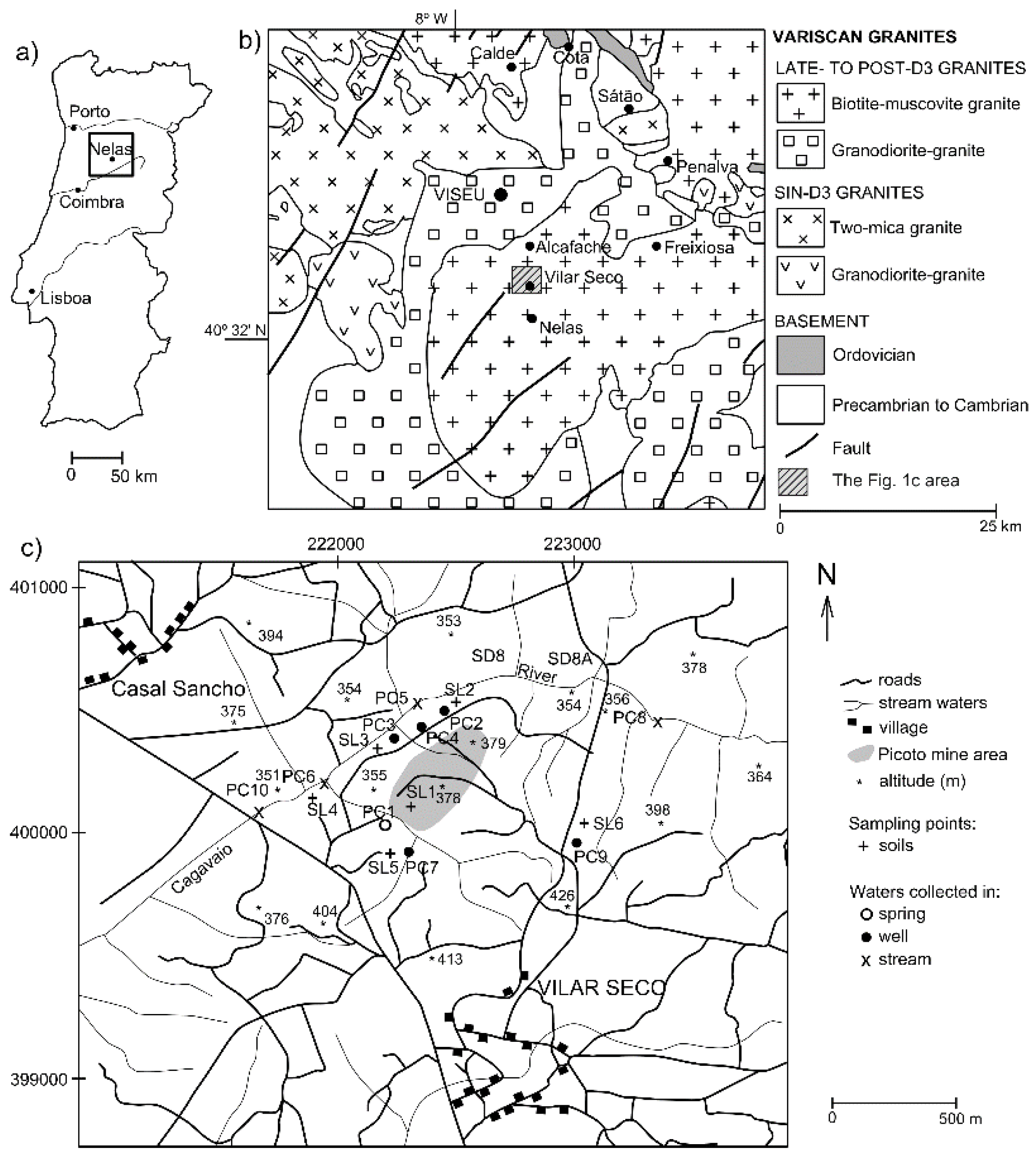
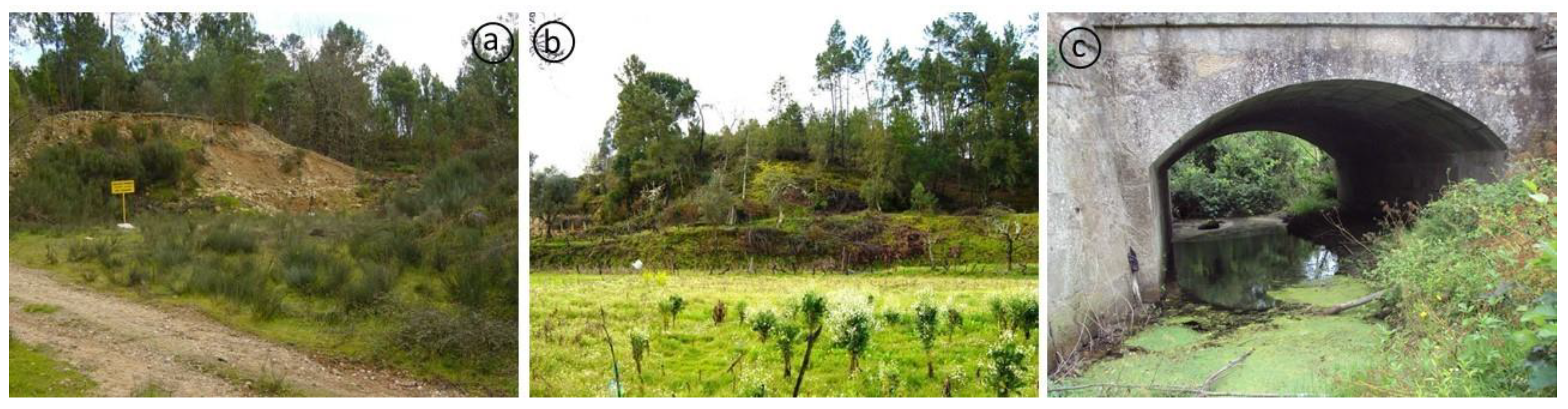
2. Study Area
3. Materials and Methods
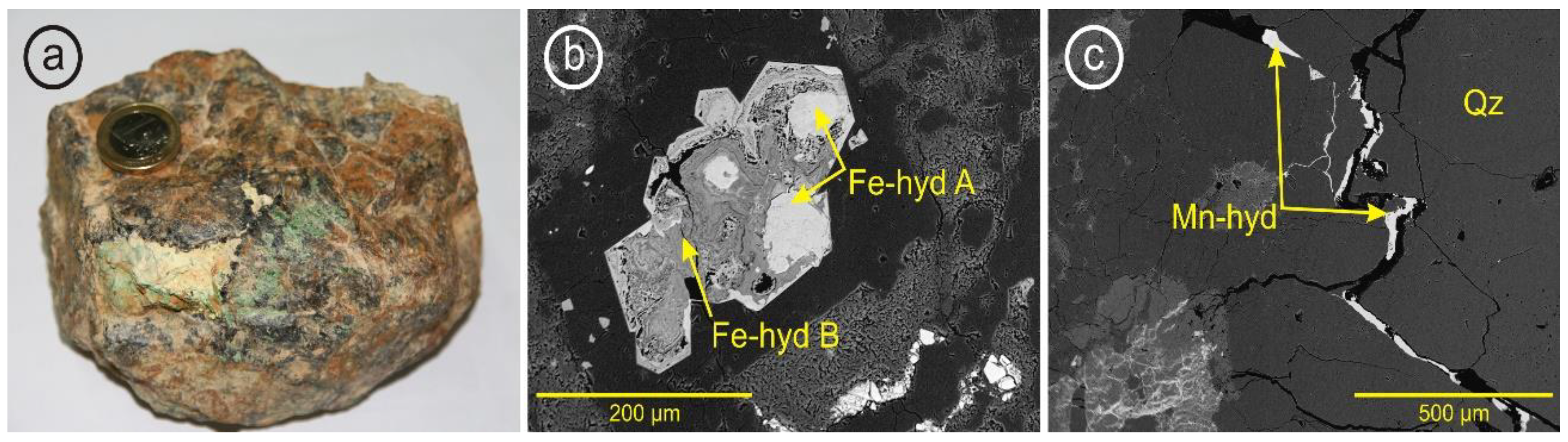
4. Results and Discussion
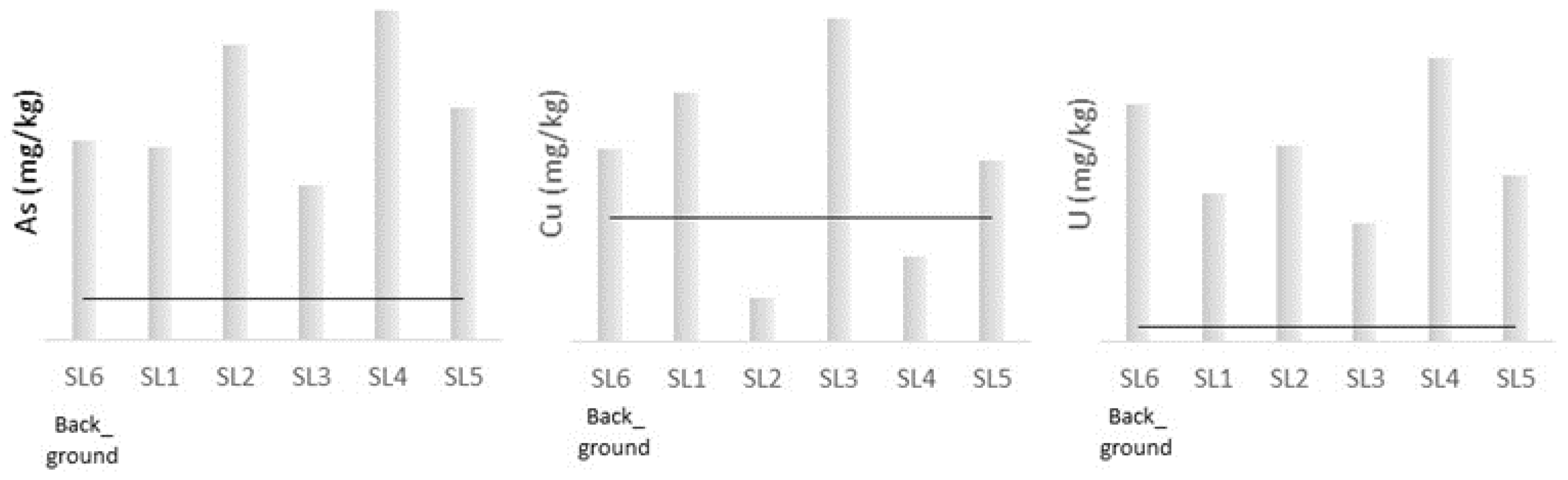
4.1. Geochemistry of Soils
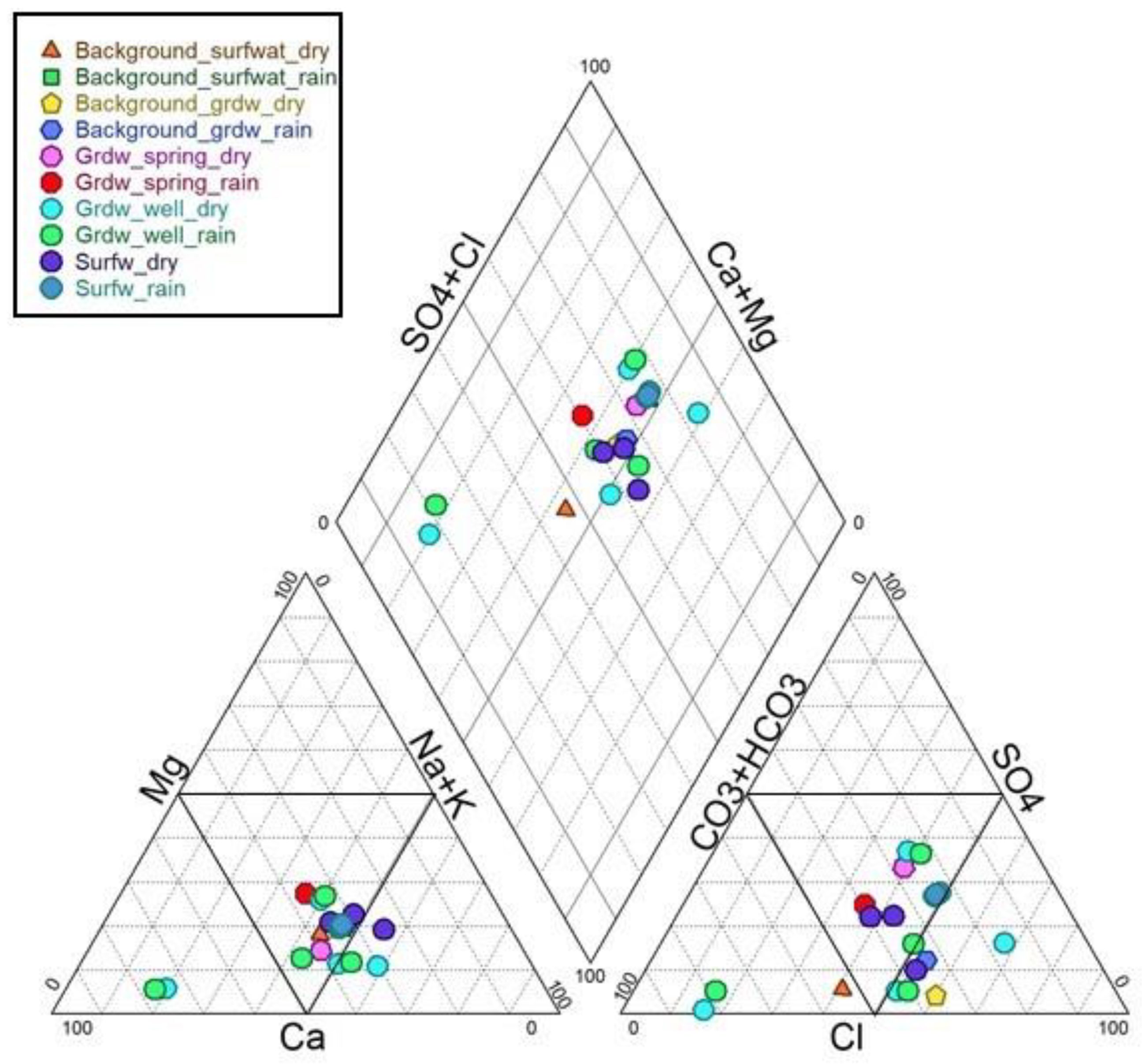
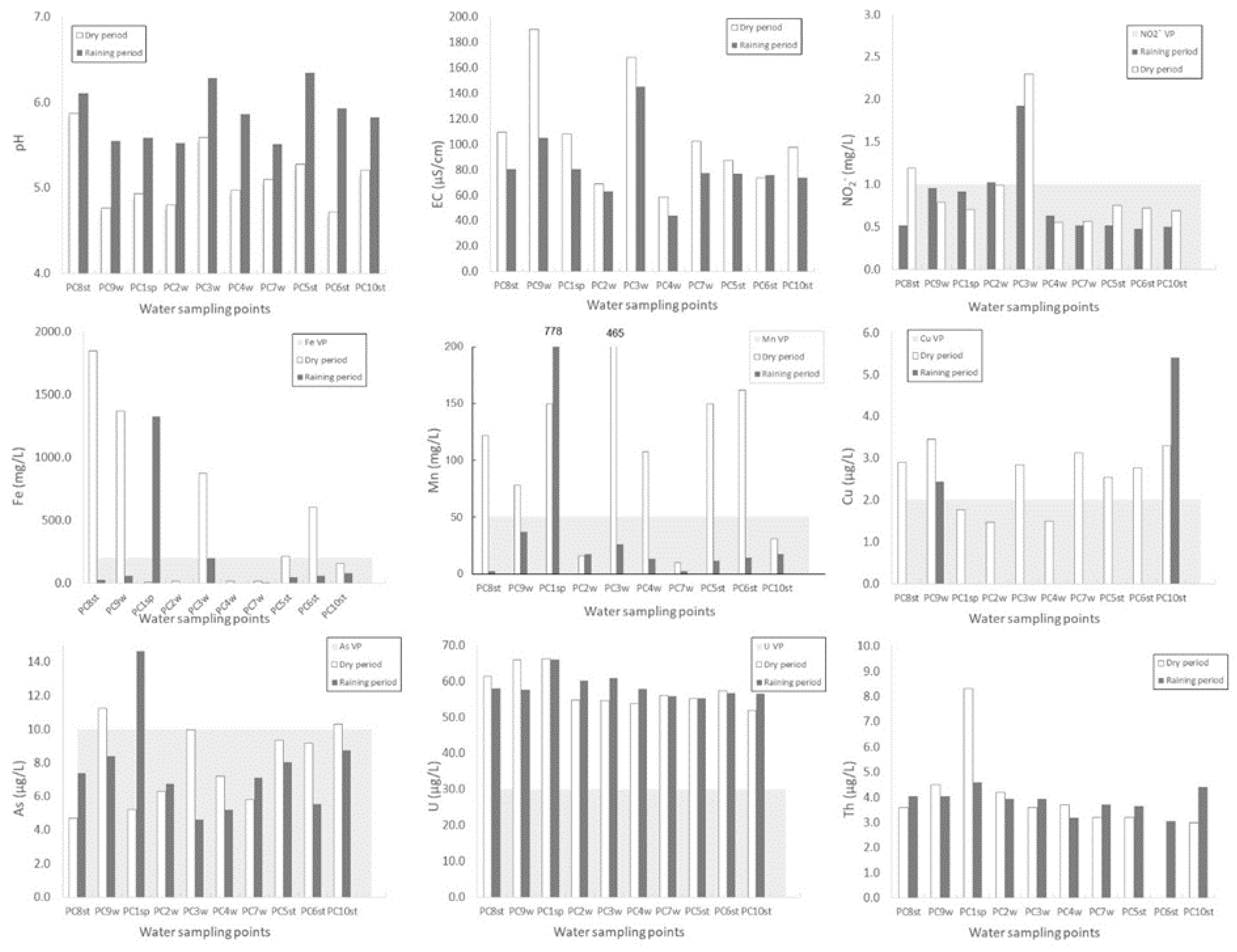
4.2. Hydrochemistry and Water Quality
5. Conclusions
Author Contributions
Funding
Institutional Review Board Statement
Informed Consent Statement
Data Availability Statement
Acknowledgments
Conflicts of Interest
References
- Brown, G.E., Jr.; Calas, G. Environmental mineralogy–Understanding element behavior in ecosystems. C. R. Geosci. 2011, 343, 90–112. [Google Scholar] [CrossRef]
- Brugge, D.; de Lemos, J.L.; Oldmixon, B. Exposure pathways and health effects associated with chemical and radiological toxicity of natural uranium: A review. Rev. Environ. Health 2005, 20, 177–193. [Google Scholar] [CrossRef] [PubMed]
- Costa, M.R.; Pereira, A.J.S.C.; Neves, L.J.P.F.; Fererira, A. Potential human health impact of groundwater in non-exploited uranium ores: The case of Horta da Vilariça (NE Portugal). J. Geochem. Explor. 2017, 183 Pt B, 191–196. [Google Scholar] [CrossRef]
- Neiva, A.M.R.; Carvalho, P.C.S.; Antunes, I.M.H.R.; Albuquerque, M.T.D.; Santos, A.C.T.; Cunha, P.P.; Henriques, S.B.A. Assessment of metal and metalloid contamination in the waters and stream sediments around the abandoned uranium mine area from Mortórios, central Portugal. J. Geochem. Explor. 2019, 202, 35–48. [Google Scholar] [CrossRef]
- Ke, X.; Gui, S.F.; Huang, H.; Zhang, H.J.; Wang, C.Y.; Guo, W. Ecological risk assessment and source identification for heavy metals in surface sediments from the Liaohe River protected area, China. Chemosphere 2017, 175, 473–481. [Google Scholar] [CrossRef]
- Zhang, P.Y.; Qin, C.Z.; Hong, X.; Kang, G.H.; Yang, D.; Pang, B.; Li, Y.Y.; He, J.J.; Dick, R.P. Risk assessment and source analysis of soil heavy metal pollution from lower reaches of Yellow River irrigation in China. Sci. Total Environ. 2018, 663, 1136–1147. [Google Scholar] [CrossRef]
- Yang, T.; Chen, J.; Xiaoping, L.; Wu, T.; Hu, Z.; Wang, S. Ecological risk by heavy metal contents in sediments within the Wei River Basin. Environ. Earth Sci. 2019, 78–101. [Google Scholar] [CrossRef]
- Cutter, G.A.; Cutter, L.S.; Featherstone, A.M.; Lohrenz, S.E. Antimony and arsenic biogeochemistry in the western Atlantic Ocean. Deep Sea Res. Part II Top. Stud. Oceanogr. 2001, 48, 2895–2915. [Google Scholar] [CrossRef]
- Elgano, L.; Kannan, R. Rock–water interaction and its control on chemical composition of groundwater. In Developments in Environmental Science; Sarkar, D., Datta, R., Hannigan, R., Eds.; Elsevier: Amsterdam, The Netherlands, 2007; Volume 5, Chapter 11; pp. 229–243. [Google Scholar]
- Redwan, M.; Abdel Moneim, A.A.; Amra, M.A. Effect of water–rock interaction processes on the hydrogeochemistry of groundwater west of Sohag area, Egypt. Arab. J. Geosci. 2016, 9, 111. [Google Scholar] [CrossRef]
- Carvalho, F.P. The National Radioactivity Monitoring Program for the Regions of Uranium Mines and Uranium Legacy Sites in Portugal. Proc. Earth Planet. Sci. 2014, 8, 33–37. [Google Scholar] [CrossRef] [Green Version]
- Pinto, M.M.S.C.; Silva, M.M.V.G.; Neiva, A.M.R. Pollution of water and stream sediments associated with the Vale de Abrutiga uranium mine, Central Portugal. Mine Water Environ. 2014, 23, 66–75. [Google Scholar] [CrossRef] [Green Version]
- Antunes, I.M.H.R.; Albuquerque, M.T.D. Using indicator kriging for the evaluation of arsenic potential contamination in an abandoned mining area (Portugal). Sci. Total Environ. 2013, 442, 545–552. [Google Scholar] [CrossRef] [PubMed]
- Carvalho, P.C.S.; Neiva, A.M.R.; Silva, M.M.V.G.; Antunes, I.M.H.R. Metal and metalloid leaching from tailings into stream water and sediments in the old Ag-Pb-Zn Terramonte mine, northern Portugal. Environ. Earth Sci. 2013, 71, 2029–2041. [Google Scholar] [CrossRef]
- Neiva, A.M.R.; Carvalho, P.C.S.; Antunes, I.M.H.R.; Silva, M.M.V.G.; Santos, A.C.T.; Cabral Pinto, M.M.S.; Cunha, P.P. Contaminated water, stream sediments and soils close to the abandoned Pinhal do Souto uranium mine, Central Portugal. J. Geoch. Explor. 2014, 136, 102–117. [Google Scholar] [CrossRef] [Green Version]
- Neiva, A.M.R.; Antunes, I.M.H.R.; Carvalho, P.C.S.; Santos, A.C.T. Uranium and arsenic contamination in the former Mondego Sul uranium mine area. Central Portugal. J. Geoch. Explor. 2016, 162, 1–15. [Google Scholar] [CrossRef]
- Antunes, I.M.H.R.; Neiva, A.M.R.; Albuquerque, M.T.D.; Carvalho, P.C.S.; Santos, A.C.T.; Cunha, P.P. Potential toxic elements in stream sediments, soils and waters in an abandoned radium mine (central Portugal). Environ. Geochem. Health 2018, 40, 521–542. [Google Scholar] [CrossRef] [Green Version]
- Antunes, I.M.H.R.; Albuquerque, M.T.D.; Roque, N. Spatial Environmental risk evaluation of Potential Toxic Elements in stream sediments. Environ. Geochem. Health 2018, 40, 2573–2585. [Google Scholar] [CrossRef] [PubMed]
- Antunes, I.M.H.R.; Santos, A.C.T.; Valente, T.M.F.; Albuquerque, M.T.D. Spatial Mobility of U and Th in a U-enriched Area (Central Portugal). Appl. Sci. 2020, 10, 7866. [Google Scholar] [CrossRef]
- Oliveira, J.T.; Pereira, E.; Ramalho, M.; Antunes, M.T.; Monteiro, J.H. Geological Map of Portugal, 1/500 000, 5th ed.; SGP: Lisboa, Portugal, 1992. [Google Scholar]
- Azevedo, M.R.; Valle Aguado, B.; Nolan, J.; Martins, M.; Medina, J. Origin and emplacement of syn-orogenic Variscan granitoids in Iberia the Beiras massif. J. Virtual Explor. 2005, 19, 1–18. [Google Scholar] [CrossRef] [Green Version]
- Cotelo Neiva, J.M. Jazigos portugueses de minérios de urânio e sua génese. In Engineering Geology and Geological Resources. Book in Honour to Prof. J.M. Cotelo Neiva; Ferreira, M.R.P.V., Ed.; Coimbra University Press: Coimbra, Portugal, 2003; Volume 1, pp. 15–76. [Google Scholar]
- Cabral Pinto, M.M.S.; Silva, M.M.V.G. The Vale de Abrutiga uranium phosphates mine, central Portugal (short communication). Chem. Erde 2007, 67, 251–252. [Google Scholar] [CrossRef] [Green Version]
- Jaques, L.; Bobos, I.; Noronha, F. Study of fluids related to hydrothermal alteration of biotite granites from Gerês and Guarda (Portugal). Comum. Geol. 2010, 97, 81–98. [Google Scholar]
- Leroy, J. The Margnac and Fanay uranium deposits of the La Crouzille district (western Massif Central, France): Geologic and fluid inclusion studies. Econ. Geol. 1978, 73, 1611–1634. [Google Scholar] [CrossRef]
- Costi, H.T.; Dall’Agnol, R.; Borges, R.M.K.; Minuzzi, O.R.R.; Teixeira, J.T. Tin-bearing sodicepisyenites associated with the Proterozoic, A-type Água Boa Granite, Pitinga mine, Amazonian craton, Brazil. Gondw. Res. 2002, 5, 435–451. [Google Scholar] [CrossRef]
- Condomines, M.; Loubeau, O.; Patrier, P. Recent mobilization of U-series radionuclides in the Bernardan U deposit (French massif central). Chem. Geol. 2007, 244, 304–315. [Google Scholar] [CrossRef]
- Cuney, M.; Emetz, A.; Mercadier, J.; Mykchaylov, V.; Shunko, W.; Yuslenko, A. Uranium deposits associated with Na-metasomatism from central Ukraine: A review of some of the major deposits and genetic constraints. Ore Geol. Rev. 2012, 44, 82–106. [Google Scholar] [CrossRef]
- Martins, L.M.O.; Gomes, M.E.P.; Teixeira, R.J.S.; Pereira, A.J.S.C.; Neves, L.J.P.F. Indoor radon risk associated to post-tectonic biotite granites from Vila Pouca de Aguiar pluton, northern Portugal. Ecot. Environm. Saf. 2016, 133, 164–175. [Google Scholar] [CrossRef] [PubMed] [Green Version]
- Murphy, W.M.; Shock, E.L. Environmental aqueous geochemistry of actinides. In Uranium: Mineralogy, geochemistry and the environment. Rev. Min. 1999, 38, 221–253. [Google Scholar]
- Cabral Pinto, M.M.S.; Silva, M.M.V.G.; Neiva, A.M.R. Geochemistry of U-bearing minerals from the Vale de Abrutiga uranium mine area, Central Portugal. Neues Jahrb. Mineral. 2008, 185, 183–198. [Google Scholar] [CrossRef]
- British Standard (BS) 7755. Soil Quality, part 3. Chemical methods, section 3.2. In Determination of pH. ISO 10390; ISO: Geneva, Switzerland, 1995. [Google Scholar]
- British Standard (BS) 7755. Soil Quality, part 3. Chemical methods, section 3.4. In Determination of Specific Electrical Conductivity. ISO 11265; ISO: Geneva, Switzerland, 1994. [Google Scholar]
- User Manual. Jobin Yvon ICP Spectrometers, Version 3.0; Reference: 321088486, January 2001; pp. 20–23.
- Xuejing, X. Analytical requirements in international geochemical mapping. Analyst 1995, 120, 1497–1504. [Google Scholar] [CrossRef]
- Min, L.; Xiaohuan, X.; Guiyi, X.; Hangxin, C.; Zhongfang, Y.; Guohua, Z.; Jiayu, Y.; Zhonghui, L. National multi-purpose regional geochemical survey in China. J. Geoch. Explor. 2014, 139, 21–30. [Google Scholar] [CrossRef] [Green Version]
- Salminen, R.; Batista, M.J.; Bidovec, M.; Demetriades, A.; De Vivo, B.; De Vos, W.; Duris, M.; Gilucis, A.; Gregorauskiene, V.; Halamić, J.; et al. FOREGS Geochemical Atlas of Europe, Methodology and Maps; Geological Survey of Finland: Espo, Finland, 2005; Part 1, p. 526; Part 2, p. 690. [Google Scholar]
- Canadian Environmental Quality Guidelines (CCME). Canadian Soil Quality Guidelines for the Protection of Environmental and Human Health—Diisopropanolamine; Canadian Council of Ministers of the Environment: Winnipeg, MB, Canada, 2017; summary tables 1–6.
- Antunes, I.M.H.R.; Neiva, A.M.R.; Albuquerque, M.T.D.; Santos, A.C.T. Spatial Surface and groundwater interaction in an abandoned radium-bearing mine (Guarda, central de Portugal). Proc. Earth Planet. Sci. 2017, 17, 618–621. [Google Scholar] [CrossRef]
- Software Diagrammes, Version 6.73; Laboratoire d’Hydrogéologie d’Avignon: Avignon, France, 2003.
- Antunes, I.M.H.R.; Gomes, M.E.P.; Neiva, A.M.R.; Carvalho, P.C.S.; Santos, A.C.T. Potential risk assessment in stream sediments, soils and waters after remediation in an abandoned W>Sn mine (NE Portugal). Ecot. Environ. Saf. 2016, 133, 135–145. [Google Scholar] [CrossRef] [PubMed]
- Empresa de Desenvolvimento Mineiro (EDM). Mina do Picoto—Relatório Interno; EDM: Lisboa, Portgual, 2007. [Google Scholar]
- Diário da República. Decreto-Lei 236/98—Legislação Portuguesa de Qualidade da água; Diário da República I-A: Lisboa, Portgual, 1998; pp. 3676–3722. [Google Scholar]
- Diário da República. Legislação Portuguesa de Qualidade da água; Diário da República I-A: Lisboa, Portgual, 2017; pp. 5747–5765. [Google Scholar]
- World Human Organization. Guidelines for Drinking Water Quality, 4th ed.; World Human Organization: Geneva, Switzerland, 2011; Available online: http://Whqlibdoc.Who.int/publications/2011/9789241548151_eng.pdf (accessed on 13 April 2021).


| Accuracy | Precision | |
|---|---|---|
| Concentration relative to detection limit (DL) | ||
| Soils <3 DL | ≤0.024 | 0.031 |
| >3 DL | ≤0.015 | 0.018 |
| Water <3 DL | ≤0.022 | 0.033 |
| >3 DL | ≤0.017 | 0.023 |
| Soils from Picoto Mine Area | |||
|---|---|---|---|
| Background | Mining Area influence | ||
| Minimum | Maximum | ||
| pH | 4.9 | 4.3 | 5.0 |
| EC | 25.0 | 17.0 | 47.0 |
| Al | 21,840.5 | 12,711.6 | 35,047.4 |
| As | 56.5 | 43.8 | 93.2 |
| Co | - | 2.9 | 3.4 |
| Cr | - | 4.7 | 8.6 |
| Cu | 97.2 | 22.8 | 163.5 |
| Fe | 18,680.2 | 15,658.2 | 25,210.2 |
| Mn | 255.9 | 149.0 | 437.2 |
| Pb | 32.7 | 18.1 | 37.8 |
| Sn | 21.0 | 17.9 | 43.4 |
| Sr | 11.1 | 5.9 | 14.5 |
| Th | 78.2 | 60.5 | 122.5 |
| U | 80.1 | 39.8 | 95.4 |
| W | 6.3 | 4.1 | 8.1 |
| Zn | 82.4 | 57.0 | 91.0 |
Publisher’s Note: MDPI stays neutral with regard to jurisdictional claims in published maps and institutional affiliations. |
© 2021 by the authors. Licensee MDPI, Basel, Switzerland. This article is an open access article distributed under the terms and conditions of the Creative Commons Attribution (CC BY) license (https://creativecommons.org/licenses/by/4.0/).
Share and Cite
Antunes, M.; Teixeira, R.; Albuquerque, T.; Valente, T.; Carvalho, P.; Santos, A. Water-Rock Interaction and Potential Contamination Risk in a U-Enriched Area. Geosciences 2021, 11, 217. https://0-doi-org.brum.beds.ac.uk/10.3390/geosciences11050217
Antunes M, Teixeira R, Albuquerque T, Valente T, Carvalho P, Santos A. Water-Rock Interaction and Potential Contamination Risk in a U-Enriched Area. Geosciences. 2021; 11(5):217. https://0-doi-org.brum.beds.ac.uk/10.3390/geosciences11050217
Chicago/Turabian StyleAntunes, Margarida, Rui Teixeira, Teresa Albuquerque, Teresa Valente, Paula Carvalho, and António Santos. 2021. "Water-Rock Interaction and Potential Contamination Risk in a U-Enriched Area" Geosciences 11, no. 5: 217. https://0-doi-org.brum.beds.ac.uk/10.3390/geosciences11050217