
Salinas and “Saltscape” as a Geological Heritage with a Strong Potential for Tourism and Geoeducation


1
Mechanical Engineering Department, ICAI, Comillas Pontifical University, 28015 Madrid, Spain
2
Institute of Saltscapes and Salt Heritage, IPAISAL, 28450 Madrid, Spain
3
Cátedra de Participación Ciudadana y Paisajes Valencianos, Universitat de València, 46010 Valencia, Spain
*
Author to whom correspondence should be addressed.
Geosciences 2022, 12(3), 141; https://0-doi-org.brum.beds.ac.uk/10.3390/geosciences12030141
Submission received: 11 February 2022
/
Revised: 8 March 2022
/
Accepted: 14 March 2022
/
Published: 21 March 2022
(This article belongs to the Special Issue Geoheritage and Geotourism Resources: Education, Recreation, Sustainability)
Abstract
:Salinas and saltscapes are relevant geoheritage sites with important implications on socioeconomic activities beyond the production of salt, particularly tourism and education. As cultural landscapes, they also have implications related to the identity of their communities. This work presents the study of the patrimonialization processes of four sites in Europe (Añana in Spain, Guérande in France, Læsø in Denmark, and Sečovlje in Slovenia). Lessons obtained from these processes may contribute to the recovery and valuation of similar saltscapes and other forms of geoheritage. The study is based on interviews with relevant stakeholders, a survey of the related grey and scientific literature, and a simplified SWOT analysis. Despite their differences in historical background and current management, all four sites share features that have contributed to the success of their patrimonialization processes, such as having a dedicated entity for this purpose or being protected in some way. They also share common threats that need to be addressed, such as the banalization of the heritage discourse. Other saltscapes and geoheritage sites in general may benefit from these common features, which should serve as an inspiration and not as a template. In the end, shifting from a little-known productive, (proto-)industrial activity toward a sustainable, multifunctional landscape in which geoeducation and tourism are paramount contributes to a more resilient and educated society.
Keywords:
salinas; saltscapes; geoheritage; cultural landscapes; geotourism; geoeducation; local development1. Introduction
Salinas are a cultural landscape type. Within the context of this paper, salinas can be defined as productive landscapes in which salt that is present in nature and forms a saline ecosystem is harvested by humans by means of different techniques (solar evaporation, seething, etc.). Cultural landscapes, on the other hand, are a blend of nature and culture, tangible and intangible heritage, and geological, biological, and cultural diversity, embodying a framework of complex relationships. The recognition of landscape as a cultural heritage, as the perceived and interpreted manifestation of a territorial reality loaded with values, reveals its protagonism in different spheres: environmental, cultural, identitarian, economic, and educational. The preamble of the European Landscape Convention (2000) indicates that the landscape plays an important role of general interest in the cultural, ecological, environmental, and social fields, and that it constitutes a favorable resource for economic activity. Its protection, management, and planning can stimulate the creation of employment. It also indicates that the landscape has a fundamental role in shaping local cultures and that it is an essential component of the European natural and cultural heritage, contributing to human well-being and to the consolidation of European identity [1]. Therefore, landscapes can and should be considered as a key element for the integral development of the individual and the community [2,3].
Saltscapes or salt landscapes are the result of the interaction between geological-geographical processes and socio-economic dynamics that, because of their multiple values, turn the territory into a “cultural geoheritage” that must be conserved, rationally managed, and taught [4]. These areas, full of geodiversity, interconnect territories, their people, and their culture. Salinas, a term that in this context refers to the salt architecture and productive activity that gives rise to saltscapes, are the result of an ancestral economic activity, based on geological resources, which in their development have generated unique ecosystems. However, not all salinas have the same characteristics, present the same model of productive activity, or have the same state of conservation. While some are in full production and are well preserved, others are in decline, endangering ecosystems, cultural heritage, and, ultimately, the landscape. In both cases it is necessary to devise valorization strategies, either to maintain the ecosystem and reinforce its social recognition, or to provide the salinas with new uses, such as tourism or education, that prevent their degradation and disappearance.
Tourism has established itself as an important economic and social activity in almost all scenarios, with emphasis on the segments related to nature and culture [5]. It is a well-known fact that tourism and cultural heritage do not always get along well, but they are mutually interdependent. How to solve this paradox? How can tourism contribute to the conservation of heritage, and to the education and livelihoods of residents? Heritage can be “activated” for the purpose of tourism [6] and heritage tourism, in turn, can contribute to create identities, not only among tourists but also within the local community. This is no trivial issue: in places where the identity of a community was linked to a certain economic activity (industry, mining, agriculture, etc.) that has subsequently disappeared, there is a threat of “dissolution of the society” (unemployment, emigration, ageing, etc.) and the local community’s identity may need to be reactivated. Heritage tourism is one of the possible tools to do so [7].
However, tourism in heritage sites or cultural landscapes is an activity that carries controversy among conservationists because they see it as a threat to the values they defend, but also as a source of necessary income to preserve cultural heritage [8,9,10]. This tension needs special attention when taking into consideration sustainability [9]. It is also relevant to see to what extent the profits of heritage tourism reach the local community and the resources they depend on [11]. From the point of view of tourism development, heritage has some virtues: it can be overtly promoted by public administrations; it is—in principle—free of charge and owned by society in general; it can be visited almost any time of the year; and it offers an air of respectability to the travel experience. Despite these tensions, as said, authorities and the private sector tend to see heritage tourism as a tool to enhance the economic activity in their area of reference, and even as an educational tool. Current tourists originating from a post-industrial society, often seek meaning in their activity. This type of visitor is better informed and prefer destinations with ecological, ethical, and social values. Some of today’s tourists want to differentiate themselves from mass tourists, although authors such as Urry and Larsen or Dujmovic and Vitasovic argue that postmodern tourism also has its shadows, such as experiential travel with excessive cultural simulations. Nevertheless, tourists in general have become more demanding and there has been an increase in the creation of new services based on emotions and cultural and landscape experiences [12,13]. In this sense, it is important to identify, analyze and enjoy the benefits of educational potential of this multidimensional phenomenon, in the formation of sensitive citizens aware of the role of the cultural landscapes as something inherent to the well-being and individual and collective identity. With cultural tourism the public can understand the environmental processes, appreciate the different aspects intervening in the history of the local community visited, and demand products and services that require the conservation and management of heritage sites [14,15].
It has been shown that cultural tourism brings potential benefits to other sectors of activity [10]. Direct profits may go to companies presenting heritage to the public (e.g., communications, engineering, and design) and indirect benefits to those that take advantage of the presence of public enjoying leisure activities (e.g., hospitality, fashion, and design), and these will, at the end of the line, revert to the conservation of the heritage and landscapes they depend on. Among the benefits of the link between heritage tourism and local development, two groups may be distinguished: a priori benefits, among which are the creation of employment, increased profits, and improved training of stakeholders. Ultimately, benefits include an improvement in quality of life, a better-quality cultural tourism, enhanced social inclusion, and stronger local development [10]. One important benefit of heritage tourism is the preservation of the landscape that host(-ed) the heritage assets in question. Whatever the activity (agriculture, mining, industry, etc.), the public will be able to gain a better insight if the landscape can be “read”. In the case of operating salinas, the heritage will be alive. Hence, from a paradigm of “What can heritage do for tourism?” we have moved on to “What can tourism to for heritage?” [16].
Cultural tourism may favor sites with sensitivity toward their heritage and that actively contribute to its conservation [17]. Visitors also want to actively participate in the experience, engaging in “creative tourism”, that is, becoming producers of their own consumer goods and services on site [18]. The global economic crisis and later the pandemic have spurred an upsurge of so-called slow travelers, characterized by travels within the region, especially to rural areas, the search for wellness and health, and short breaks and day trips [19,20,21,22,23]. An important motivation found in slow travelers is the quest for meaningful and participatory experiences rather than for witnessing people and places passively [18,24]. Cultural tourism is no longer just an activity that presents artifacts to tourists, but one that takes into account the relationship between the visitor and the heritage presented, especially when including intangible heritage, which in turn helps visitors get “emotionally involved” in a “heritage experience” [18,25,26]
Salinas epitomize the complexity of cultural landscapes in which human, cultural, and natural features are intimately linked and are mutually dependent for achieving and maintaining sustainability. In addition, salinas are or can be living landscapes without the need to change them into surrogate or fossilized “heritagescapes”. This strength of salinas has also been its weakness. The built heritage in salinas is pragmatic, modest, and, because of the materials used, easily degraded, hence not attracting the attention of architects and other heritage specialists. Unfortunately, changes in society and history in the past decades or even centuries have motivated the disappearance of numerous salt-making sites worldwide. A loss of around 90% has been registered [27]. By all measures, this is a serious threat to the remaining sites. Those that have not been transformed into industrial saltworks (e.g., roughly half of the remaining coastal sites in Spain) are under threat of abandonment. Hueso-Kortekaas presents an extensive review of the fate of Spanish and European salinas [27,28].
This research as a threefold goal: first, to characterize the patrimonialization process of four well-managed saltscapes across Europe. This process describes the gradual transformation of a resource-based productive activity (in this case, salt), usually in decline, into a multifunctional landscape with a heritage-based economic activity. Typically, the first stage patrimonialization takes place after the abandonment or irreversible decline of the production of salt and is then activated by interested stakeholders, usually NGOs or public administrations. After activation follows a stage of professionalization, in which the heritage asset or landscape is taken care of by individuals or organizations that have expertise in the topic, although still somewhat patchy. This stage merges onto the consolidation of the process in which a specific, dedicated entity is created and a budget is allotted for the conservation, promotion and use of the site. This is the optimal stage from the point of view of patrimonialization, as it provides stability and a strategic long-term vision [27].
The sites have been selected upon the basis of their heritage values (all of them enjoy a certain degree of protection and have a relevant historical background) and their dedicated heritage management, which consolidates their success in the transition from saltscapes in decline to complex geoheritage sites with a multifunctional character (production of salt, tourism, wellness, and education). Second, common features are sought by means of looking at the lessons learnt in the patrimonialization process, and a simplified spatial SWOT analysis is performed. Third, the work aims at extrapolating the results to other saltscapes and similar forms of geoheritage, which may contribute to better-targeted efforts and more efficient results in the protection and valuation of other saltscapes and geoheritage in general. This paper is organized as follows. Section 2 introduces the data collection techniques and SWOT analysis methods used in the study, before Section 3 exposes the results. Finally, in Section 4, the results are discussed and some ideas for future work explained.
2. Materials and Methods
2.1. Selection of Study Sites
Four study sites were chosen, namely Valle Salado de Añana in Spain, Marais salants de Guérande in France, Sečovlje soline in Slovenia, and the Læsø saltworks in Denmark (Table 1). The selection of all cases responds to one criterion: that is, whether they are or have been in the process of patrimonialization. This means that the selected sites do not only produce salt, but also have other areas of economic activity focused on the public: tourism, health services, or educational activities. They harbor significant heritage values, which are acknowledged by different instruments of legal protection of natural and/or cultural assets, and count with a relevant historical background at regional and national level. These are sites also known for their successful management of the artisanal salt-making activity in a balanced combination with the protection of natural and cultural values, as well as the provision of a livelihood for the local community. The cases selected also have in common that the patrimonialization process is found in an advanced stage and can serve as an example or paradigm for others. In addition, these sites produce salt by traditional methods, reinforcing the idea of heritage conservation and transmission. The four areas are thriving examples of heritage recovery at a regional level and are well known on an international scope. Having said this, the sites differ considerably from each other in their past and recent history and how the process is driven. There are more cases in Europe and elsewhere, but their diversity of patrimonialization processes showcases different possible pathways to success.
2.2. Bibliographic Survey
An important part of the work relied on the consultation of written literature. The sources covered both scientific as non-scientific literature. The search has been, therefore, eclectic by nature (from systematic key-word use in Google Scholar and Google News to the websites of the companies or organizations in charge of the sites, including cross references from any written document or oral referral). Google Scholar was preferred above other scientific portals because it also provides references to grey literature, which is very relevant in this context. The latter include unpublished reports, plans, and projects or internal documents and have usually been published by non-profit organizations and authorities.
2.3. Interviews with Stakeholders
Understanding local development around a saltscape (or any other form of landscape-based heritage) requires the appropriate identification of stakeholders. Stakeholders are any person or organization that feels affected by any event related to this form of heritage or landscape.
The main challenge of this part of the research has been finding the right stakeholders in each of the study sites, given the variety of roles and profiles [29,30]. They are organized or not in formal, known structures, or may be informal opinion leaders without apparent filiation. Some of them may have the right information, but not the capacity or willingness to participate in the research [11]. Stakeholders who have been relevant in the recent past but are now disengaged from the site have also been considered, especially those who have inspired or triggered management practices that have been used for some time or still are. The main method to find stakeholders in the field was the snowball, by which first-level contacts provided new contacts that were deemed relevant in the context of this work.
Interviews have been performed with 10–12 key stakeholders per site in relation to past, present, and future plans and projects in the study sites involved. Their roles included owners and managers of the salinas, local public administrations, tourism authorities and businesses, (nature) guides, academics and scholars, spa and wellness managers, and, of course, salt makers.
The interviews were semi-structured. The reasons to choose this format were threefold [31]. First, the situations tackled were very different between and even within sites, which required flexibility in the design and development of the interview.
Second, the information needed was rather complex and the responses were expected to differ significantly, both in tone and in content, depending on the stakeholder involved. Third, the need to create a relaxed atmosphere, especially in group settings or with biased stakeholders, recommended this user-friendly format.
2.4. Field Visits and Observations
The field visits were intended to observe first-hand the state of the salt-making site and the surrounding landscape, to visit the businesses and other facilities associated to salt, and to perform the interviews with local stakeholders. Direct observation allowed us to improve the understanding of the site, the decisions of its owners or managers, and the relations among stakeholders. The field visits provided an opportunity to register the most relevant features and significant events related to or resulting from the management of the salt-making site and also a holistic, integrated view of its hinterland.
2.5. Spatial SWOT Analysis
To understand the current situation of artisanal salinas and how they face the future, it is important to have a deep knowledge of them and of their hinterland. Spatial SWOT analysis is a method frequently used to elaborate on strategic territorial diagnoses and make decisions. The SWOT is a classic analysis tool for strategic management enterprise proposed by Kenneth Andrews (1971) [32] that has been transferred to territorial planning and cultural management. Spatial SWOT analysis plays a dual role. It fills in the gap of scientific knowledge and local data and is an approach that synthesizes the information collected through different sources [33,34,35].
Its name comes from the four ideas that it focuses on: strengths, weaknesses, opportunities, and threats. The items “strengths” and “weaknesses” refer to the current intrinsic aspects of the sites, whereas the items “opportunities” and “threats” are related to their sociocultural and business environment and typically hint at situations that will arise in the future. SWOT is an appropriate diagnostic and evaluation tool to obtain an initial idea of the state of the saltscapes and their possible future evolution. The benefit of this method is its simplicity. Moreover, it is user friendly and does not require computer systems or software [36,37].
In this work, the SWOT matrix analyzes the internal strengths and weaknesses, as well as external threats and opportunities, to guide the future expected strategies. The objective of this matrix is to determine all applicable strategies. First, by using the internal strengths we attempt to exploit the external opportunities and maximizes them. Second, using the present opportunities in the internal environment we attempt to improve weaknesses. Third, using the strengths counteracts the effects of current threats and, fourth, the internal weaknesses are minimized and threats caused by the external environment are prevented.
3. Results
3.1. The Values of Saltscapes
Common salt (NaCl) is an essential constituent for living beings. It is found in nature in the form of rock salt in layers at different depths of the Earth’s surface; or dissolved in surface water and groundwater (oceans, lakes, springs, or saline aquifers). Sea waters contain an average of 35 g of salt in solution per liter, which varies between warmer seas such as the Mediterranean and the Red Sea, which have a salinity of 37 and more than 40 g per liter, respectively, and colder seas such as the Baltic, which barely reach 10 g of salt per liter of water. In the case of salt sources, the circulation of water between salt deposits dissolves and transports the salt in solution over long distances in saline aquifers until it reaches the surface, sometimes reaching salinities of over 200 g of salt per liter.
Halophile vegetation absorbs NaCl in solution and incorporates it into the food chain. Wildlife and humans consume vegetables and other animals, incorporating salt into their diet. However, that being insufficient, they collect brackish water or lick rock salt, because salt is essential for their survival. It has specific functions in each of the metabolic cycles and in cellular nutrition. Our body has no reserves of sodium chloride, so it must constantly regulate the amount of salt present through the kidneys and urine [38].
But in addition to the importance of sodium chloride at an organic level, we cannot ignore all the culture that has been generated around its use: food, therapeutics, salting, preservation of skins, industry, religious rites, etc. This is the reason why salt, together with cereals and wine, was considered the basic trilogy of the Mediterranean economy from antiquity until practically the 20th century. Since Neolithic times, humans have collected salt for a variety of purposes. Salt production, trade, and use are at the basis of the so-called saltscapes: environmentally unique sites with a very powerful historical, cultural, and symbolic significance. Therefore, the historical value of salt has left its imprint on the territory and on culture: the salinas themselves, but also trade relations, taxes, by-products, etc. The salinas have allowed a social and ecological coexistence by reconciling the exploitation and sustainable use of the territory. They have contributed to human supply and environmental heterogeneity, and increased biological diversity, playing a key role at the ecological, anthropological, landscape, socio-economic, and cultural levels [39]. Saline water generates ecosystems with special features. They are wetlands in which salinity acts as a limiting factor. However, the organisms that occupy these fragile and unique ecosystems serve as food for many species of birds that nest and rest in them. When humans develop an economic activity to produce salt, environmental and landscape conditions are modified. The surface area occupied by brackish water increases and a semi-industrial architecture is created (ponds, pools, threshing floors, canals, roads, warehouses, etc.) with ecological, cultural, and heritage implications. Saltpans become habitats for organisms that thrive in a range of extreme salinity, temperature, pH, nutrient concentration, oxygen availability, and solar radiation. The production process involves increasing the concentration of salt in the water until it becomes brine. As salinity increases, some organisms are replaced by others: halophilic micro-organisms, including bacteria, archaea, and fungi, which are important in the biogeochemical functioning of salinas [40,41]. Halophilic algae incorporate energy into the system, feeding crustaceans such as Artemia sp., which in turn feed the birds [42], making the salt pans important sites for various species of flora and fauna.
However, it should not be forgotten that these unique habitats have their origin in a productive anthropic activity, which began with the collection of salt precipitated in the hollows of coastal rocks or in the beds of salty rivers, and which has evolved into the construction of semi-industrial facilities. The geographical features of a territory are determinant in salt production [43,44]. Therefore, the production process involves knowledge of the environmental processes and the construction of an infrastructure for the management of salt water. The salinas are made up of a set of shallow artificial ponds at different topographical levels, to which seawater or water from saline springs is transported by means of a network of canals. The salt is obtained in these ponds after a first concentration stage and a second crystallization stage.
The physical process of the evaporation of brackish water requires an external energy source that increases the temperature of the water to the point where the dissolved salts begin to precipitate, forming salt crystals. The latitude and location provide favorable climatic characteristics (high annual sunshine and low rainfall during the harvesting season; winds to accelerate evaporation) so that salt production depends exclusively on the use of direct solar energy [45,46]. In sites where climatic conditions are not suitable for solar evaporation, the alternative has been to induce brine evaporation by a wood combustion process. On the other hand, the topographical characteristics are relevant in its location, since it is a process that requires important extensions of land on which to build the evaporation ponds.
Obtaining salt does not depend only on the production infrastructure. The experience and know-how of the salt makers has also been relevant when it comes to achieving greater production and higher levels of purity in the salt (NaCl). Sodium chloride is not the only salt present in the water. The construction of a succession of ponds of different depths and at different elevations makes it possible, on the one hand, to saturate the water, converting it into a brine, and on the other to precipitate—in the first set of ponds—other salts that are less soluble than sodium chloride, such as CaCO3 or CaSO4, which are present in the water. Finally, the practically saturated brine (25.7 °Baumé) is redistributed to the crystallizers. These are square or rectangular ponds, no more than 15 centimeters deep and with a flat bottom, also known as saltpans, where NaCl precipitates at 28–29 °Baumé.
In both coastal and inland salinas, the production process does not end with the crystallization of sodium chloride. Once the NaCl has precipitated, the brine contains other more soluble salts, so the water can be reused to obtain sodium and magnesium sulphates, which are used in the glass and soap industries or in cosmetics, respectively. Finally, the salt itself must be accumulated, dried, and protected from possible inclement weather. Thus, a building linked to the salt installation is needed: the warehouse, where the tools of the salt workers were also kept.
In some inland areas, the abrupt relief makes it almost impossible to have flat surfaces to build the crystallizers. To make up for this lack of horizontality, a system of artificial terraces is set up on the slopes, based on stone and wood structures. The upper part of the terraces is used as a saltpan, while the space between the embankment and the structure is used to store the extracted salt. A salina is therefore a natural, scenic, and cultural heritage that demonstrates the human use of geological resources and shows the intimate relationship between humans and nature that goes beyond the sheer extraction of a raw material.
According to Quesada and Malpica, the production of salt in the salinas resembles an agricultural process because, first, the land must be conditioned and transformed as if it were cultivated fields. As in agriculture, it is necessary to build structures (terraces, banks, and pipelines). Second, there is an assimilation of hydraulism, as found in irrigated agriculture. Water management is typically based on four pillars: catchment, transport, storage, and distribution. Third, it does not require a complex infrastructure, nor investment in manpower or their training because expertise is acquired with practice. Fourth, an idea of “harvesting” is generated from the use and management of natural resources [45,46,47]. Having made this analogy, it is important to highlight not only the ecosystem services offered by salinas, but also the economic and cultural ones. They are productive cultural landscapes with multiple values, so they must be managed in terms of conservation of geological and geomorphic processes, conservation of biological processes, production of goods, and production of tourist and educational services [48,49].
3.2. Landscape and Geoheritage Characterization of Study Cases
Each case study has, as expected, unique features and narratives. In this section, a brief description, and a summary of the recent history of each site is provided, in relation to its patrimonialization process. Table 2 summarizes the main features of the patrimonialization process of each site. However, patterns can be found with respect to these processes that allow the identification of strengths and weaknesses, as well as lessons taught, for saltscapes and salt heritage in general. These are offered at the end of this section.
3.2.1. Valle Salado de Añana (Basque Country, Spain)
The cultural landscape of Valle Salado de Añana (42°48′ N, 2°59′ W, 531 m a.s.l) is located in the southwest of the Basque Autonomous Region. The salinas lie in a deep Y-shaped valley formed by the River Muera (brine, in Spanish) and occupy a surface of ca 10 hectares (Figure 1). Brine is obtained from wells that tap groundwater that has been in contact with the diapir just below. The brine is then distributed via aerial wooden carved channels to the crystallizers located in wooden terraces built on the slopes. The origin of the saline aquifer lies in the presence of a diapiric structure derived from the intrusion and tectonic uplift of evaporite rocks dating from the Triassic period—facies Keuper (salts, gypsums, and clays) through denser materials [50]. When surface runoff waters infiltrate and circulate through these materials, they are loaded with salts and become brackish or brine. These brackish waters arise to the surface in the form of saline springs. From there, the brine, which flows with a salinity level of 210–240 gr/L, is conducted by gravity through channels toward the crystallization pans, which are arranged in terraces on the slopes of the valley. Once the brine is distributed over the saltpans, the sun evaporates the water and salt crystallizes, just as in other solar evaporation salinas. The geological origin of the salt and the geomorphology of the valley explain the uniqueness of this landscape from an environmental perspective [50,51].
Salt making in the area has been documented from the year 822 C.E., but recent archaeological research has found evidence of salt-making activity as early as 7000 B.C.E. [52]. The saltworks flourished in medieval times, under the control of the salt workers-cum-owners organization known as the Community of Heirs. As occurred with many other salinas in Spain, in 1564, under King Philip II, they became state-owned during a prolonged period. In 1869, the Community of Heirs recovered the power over the management of the salinas and the traditional salt-making methods they had been using in the past. Due to competition from other salinas, productivity was being increased by irrationally enlarging the surface of crystallizers, building them on dangerously steep slopes, above the level of the sources or using new materials that proved useless, such as concrete. The latter caused major damage to the wooden structures and pollution from debris in the valley. Despite these modernization efforts, salt was still being harvested by hand [53].
In 1960, the valley had about 5000 crystallizers in operation, which went down to 150 in 2000. Production decreased from 4000 tons to hardly 3. In the years 1999–2000, the salinas were practically inactive [54,55,56,57]. The Valle Salado was declared a BIC (Good of Cultural Interest, in its Spanish acronym) in 1984 with the category of Monument. The Diputación Foral de Álava (provincial administration) initiated a series of actions to recover the valley. In the years 1998 and 1999 the Comunidad de Herederos de las Reales Salinas de Añana (Community of Heirs) became a private company, the Sociedad de Salineros Gatzagak, S.L., which gathered all the owners of the crystallizers. With a contemporary legal structure, the ownership became unified, and third parties had one single representative to address, thereby facilitating the recovery of the valley. In 2009, the Fundación Valle Salado (Valle Salado Trust) was founded, its trustees being the provincial government, the Basque regional government, the municipality of Salinas de Añana, and the Company Gatzagak S.L.
A 20-year Master Plan with a budget of EUR 20 million was devised, setting the physical limits of the monument in order to better determine its functional and landscape recovery and to organize the management and activities of the salinas and its environment to enhance its use and enjoyment by all [58,59,60]. With the turn of the century, the first measures to create public access to the salina were taken (Figure 2). The public was invited to visit the works, under the motto “Open for repairs”. The visitor program of Añana is an ever-growing activity, with ca 100,000 annual visitors in the last decade. The tourism offers range from regular guided tours to specialized tours for schools or special interest groups. Visitors can also book brine foot or hand baths and soon a flotarium will be available.
The informants generally agree that the project has brought significant benefits to the village, aside from visibility and local pride. The initial stages of the patrimonialization process were difficult, as stakeholders needed to find a common ground to agree upon and the top-down approach did not contribute to motivate the local community.
3.2.2. Marais Salants de Guérande (Bretagne, France)
The Guérande salt marshes (47°17′ N, 2°27′ W, 0 m a.s.l.) are located in the southern half of Brittany (France) between the mouths of the rivers Loire and Vilaine, facing the Atlantic Ocean. They form a very large wetland zone in western Loire-Atlantique and occupy a surface of 2000 ha (Figure 3) [61]. The current relief is the result of the razing of the Hercynian mountains, the fracturing in inclined blocks, of the post-Hercynian razing surface during the Cenozoic, and of differential coastal erosion during the last marine transgression. The geographical area has a lithological variety typical of geological history (Brioverian schists, gneiss, granite, migmatites, and Quaternary sediments) [62]. The disposition of the inclined blocks of Le Croisic-Batz and Guérande, as well as that of the isthmuses of Pen-Bron and La Baule, have created the conditions for the formation of a maritime marsh, whose clogging by sand and mud intensifies toward the base of the slope of Guérande (where it is more than 20 m thick) [61,62,63].
Salt has been harvested on the peninsula since the Iron Age. The first saltworks to use the storage capacity of the lagoon goes back to the 3rd century, shortly after the Roman conquest. The first salt marshes as are known today were shaped by the monks from Landévennec Abbey, who, in 945, carved them out by studying the tides, wind, and sun. The salinas brought prosperity to Guérande for many centuries and opened the first trading routes in Europe. Today, at least five saltworks from the Carolingian period are still in operation. After a period in the mid-20th century when the salinas were threatened with urban sprawl, certain sectors of civil society sensitive to the cultural and natural values of the site managed to reverse this threat and recover the salt marshes as they had always been. A key issue in the empowering of salt makers was the strong union formed by the different stakeholders that fought the development plans in the early 1970s, including Breton nationalists and environmentalists. This formed the seed of a strong social and political awareness in the area, that has now grown to become a solid, well-organized supporting tissue in the region [30,64].
The decade of 1975 to 1985 was characterized by the reconstruction of the salt-making activity and the recovery of the marshes (Figure 4). The main challenge was to find replacements for the ageing salt makers, as few young people wanted to take this profession.
Thanks to the arrival of interested apprentices from other regions, the activity gradually regained momentum. Because of this interest, in 1979, a training center for young salt makers was opened. The tradition of the salt worker’s profession was thus recovered, and the preservation of these skills have allowed the Guérande marshes to survive through to modern times. Today, about 16,000 tons of coarse salt and 700 tons of fleur de sel are produced each year.
The public interest in hand-harvested (as opposed to industrial) salt was gaining strength and so did the tourism pressure in the area. Salt makers still saw tourism as the main threat to their livelihood but slowly started to see visitors as partners rather than enemies in their quest to defend their profession and their landscape. The relationship between salt makers and visitors gradually improved over time and the creation of the visitor center Terre de Sel further contributed to regulate and ease the previous tensions between them [64]. It organizes thematic guided visits, also catering to school groups. Two other museums exist around the world of salt making in the neighboring locations of Batz-sur-Mer (Musée des Marais Salants) and Saillé (Maison des Paludiers), the three of them receiving more than 130,000 visitors annually. Today, the area of La Baule–Presqu’ile de Guérande has a well-developed tourism industry. Guérande receives 1.2 million visitors per year. It is calculated that one-fifth of the revenues generated in the area are related to tourism and more than 8100 people are employed in this sector [63,65].
The informants generally present positive feelings about the patrimonialization process, which was initially rough. However, there remain some differences in the focus, as some paludiers believe the essence of the site is being lost because of the commodification of the salt itself and the concept of fleur de sel in particular. In fact, some salt masters do not wish to belong to the cooperative for this reason (G.P., pers. comm.). On the other hand, nature conservationists perceive a pressure to recover more surface for salt production and feel it will cause a detrimental effect on habitats and birds (D.M., pers. comm.). In such a large site, striking the right balance seems difficult.
3.2.3. Læsø Saltworks (North Jutland, Denmark)
The Læsø saltworks (57°15′ N, 11°2′ W, 0 m a.s.l.) are located in the southeast of the island of Læsø in northernmost Denmark (Figure 5). As Jørgensen explains, the area is the marine foreland composed of four minor low islands, a belt of coastal meadows and salt marshes and wide areas of sand in shallow water [66]. The terrain is practically flat (low altitude and minimal slope) and the existing vegetation depends on the seawater level. From the inner part toward the coast, the meadows gradually transition into salt marshes. The geology present in the area is composed of a thin cover of sands and silts intertwined by layers of sands and coarse gravels. Beneath these materials is interglacial marine stiff clay [66,67]. The saline water to produce brine and salt is captured from the aquifer formed by post-glacial marine sediments, which has salinity percentages above 17%.
Salt is being produced by seething, using wood as fuel. The brine is pumped from the salty water table of Rønnerne, in the nearby sandbanks of the southern edge of the island. This brine is twice, or three times as concentrated as seawater and is collected in wells to be further concentrated. The brine is then boiled or seethed to obtain a product of high-quality, equal to the famous salt from Lüneburg in Germany.
In the Middle Ages the Læsø saltworks were the most important workplace of the island and were considered the first industry of the time. Salt production stopped in 1652 because seething salt in the huts required large amounts of biomass. By then, the salt industry had used up all the fuel wood on the island and the island was transformed into a windswept desert. The ruins of the old huts where the salt was boiled are still standing as low, square embankments. There are an estimated 1000 of them on the island.
Archaeological research in the mid-20th century revealed how salt making was done a few centuries ago. From the results of the excavations in 1990 it was decided that the Municipality of Læsø would rebuild a salt seething hut, originally with an educational purpose. The goal of the project was partly to put Læsø on the map by telling its unique story about salt, and partly to contribute to the archaeological knowledge on seething by restarting the salt-making activity on the island according to 16th century methods [68,69,70,71]. Initially supported by the public authorities, it quickly grew into a thriving productive activity with a keen interest from visitors.
It was soon decided that the visits should be free of charge. In exchange, the salt was sold at a high price, but that was justified as a support to cover the costs of the project. In the first years, the usual high costs derived from salaries were cut because of the participation of the school workshop of the island, whose employees were hired to work in the huts. Læsø Saltworks uses between 1000–1500 cubic meters of firewood every year, less than 10% of the current harvest of forest products, well below the limit of sustainability. Today the salt making activity is highly organized and successful.
The saltworks are making an important contribution to the economy of Læsø. As a tourist attraction, the saltworks receive more than 60,000 visitors per year, half of the total amount of visitors to the island. The saltworks produce ca. 70 tons of salt per year, selling both locally and all over Scandinavia. The salt is highly valued by customers and visitors and has become a culinary reference in high-end restaurants in the region. The new saltworks were never conceived as a museum, even though its main revenues come from tourism (Figure 6). Visits are still free of charge, because the site is considered a living place of production, in full operation and visitors come for the experience [72].
Perhaps the single most relevant new business associated with salt is the thalassotherapy center, Læsø Kur, which opened in 2008 in a deconsecrated church. In just over 1 year, the center offered numerous therapy services (sauna, steam bath, cool water pool, mother lay baths, jacuzzi, and massage), leisure, and beauty treatments. The center has an agreement with the Danish health system to offer packages for patients and, of course, anyone interested can purchase their own wellness or therapy packages.
All informants agree upon the benefits of the patrimonialization process and do not manifest critical views of it. It seems to have had a net positive impact on the economy of the island, also beyond the salt-making and tourism activities themselves (B.B., P.C., P.S. pers. comm.). Some initiatives did not survive (e.g., a salt-themed restaurant), but generally speaking there is a broad consensus about the success of the process.
3.2.4. Secovlje Soline (Istria, Slovenia)
The Sečovlje salt pans (45°29′ N, 13°36′ E, 0 m a.s.l.) are located in the southwest part of Slovenia, (Gulf of Trieste, northern Adriatic), next to the border with the Republic of Croatia, on the Istria Peninsula. The Slovenian coast, albeit short, is highly varied. There are cliffs, shingle beaches, and coastal plains (lagoons and wetlands). This last type of coast is the result of the accumulation of large quantities of fine sediments, deposited by the Soca, Rizana, Badasevica, and Dragonja rivers, facing a shallow sea with a shelving sea bottom. The Slovenian coast evolved in the Holocene. Vahtar explains that the valleys have been transformed into bays, with alluvial sediment deposition still ongoing, while ridges changed into peninsulas developing cliffs at the coastline [73]. The rock materials are Eocene flysch, while in the plains, fine-grained alluvial sediments predominate. The Sečovlje salina is a coastal marsh wetland developed on a sedimentary plain of the Dragonja River [73,74]. It consists of two parts. Its northern section, where salt is still being actively produced and harvested, is known as Lera. The southern section, called Fontanigge, is separated by the Grande–Drnica channel (Figure 7).
The Sečovlje salinas are today the largest coastal marsh wetlands (650 ha) in the country, and at the same time the most important Slovenian locality from the ornithological point of view. Today, 272 bird species have been found in the salinas, with some 90 breeders among them. Based on these facts, the Government of the Republic of Slovenia in the year 2001 declared the Sečovlje Salina Natural Park and the adjacent Museum of Salt-making as a cultural monument of national importance. In 1993, the salinas became the first Slovene wetland, inscribed on the list of internationally important marshes under the auspices of the Ramsar Convention. The salina represents different ecosystems, from marine to brackish, fresh water and land ecosystems.
The traditional manual harvesting of salt in these salinas, over 700 years old, is a representative feature of the cultural heritage of Mediterranean Slovenia. Until the beginning of the 20th century, the saltworks were owned by wealthy families, churches, monasteries, and charitable institutions. The salt worker was merely the tenant of the salt field and the producer of the salt. The golden age of salt making in Sečovlje lasted from the 15th century to the end of the 18th century, under the control of the Venetian Republic [75]. In 2000, the Sečovlje Salinas Nature Park was designated the first protected area in Slovenia when the concession for its management had been given to a business company (SOLINE Pridelava soli d.o.o.), which is owned by the national biggest phone company (Mobitel d.d.). The company is responsible for the management of the state-designated Nature Park and use of its natural resources. The company also is responsible for the protection of nature in the state-owned property of the Sečovlje Salina Nature Park. In return, the Republic of Slovenia provides funding for the management of the protected area [76]. The park receives 30,000 to 45,000 visitors per year, mainly during the summer [77]. Their salt is well known in the Eastern Mediterranean and the site constitutes an example of good management practices and smooth transition from a communist to a capitalist economic system.
In general, the informants agree that the saltworks have a positive influence on the local economy, although there seems to be certain lack of coordination between stakeholders. There are pending issues, such as the access to the salt museum in the border between Croatia and Slovenia, or the management of visitors to the protected area within the productive area of Lera (F.B. and D.C., pers. comm.).
At the turn of the millenium, 593 ha of salt-making surface were recovered in Fontanigge (only for the provision of brine) and in Lera (for the whole salt-making process, which accounted for 25 salt-making units). In 2002, 18 men were employed who produced 100 tons of salt. A decade later, more than 94 hired workers produce up to 5000 tons of salt and 30 tons of fleur de sel per year (Figure 8). In 2013, the company SOLINE Pridelava d.o.o. decided to invest in a thalassotherapy center to take advantage of the two subproducts of salt making with healing properties, namely the mud (also known as fango or peloid) and the mother lay or acqua madre. The complex, named Lepa Vida, was built within the natural protected area and has a total surface of 4000 square meters.
3.3. Common Features of the Patrimonialization Processes of the Four Study Sites
The four study sites can be considered consolidated examples of patrimonialization and sound use of geoheritage. Despite their differences in ownership, management, heritage assets, and funding, they share some common features that may be contributing to their success. All four sites have some form of protection status, some more diverse, including both natural and cultural values (Añana, Guérande), than others that focus on the natural aspects (Sečovlje, Læsø). From the point of view of management, the four sites count with a specific, dedicated entity: the Valle Salado Trust in Añana, the Cooperative de Salines de Guérande in Guérande, the company Læsø Salt in Læsø, and the company Soline Pridelava in the case of Sečovlje. These entities oversee the management, financing and long-term strategies for the protection of geoheritage, education, and tourism in their respective locations. They are all but financially self-sufficient, with gradually decreasing government support in the cases of Añana and Sečovlje and none in Guérande or Læsø. In all cases, albeit with slight differences in priorities, they form multifunctional landscapes with a focus on four aspects: artisanal salt making, tourism, education, and wellness products and services. At this point in their geoheritage development and use, two risks need to be taken care of.
On the one hand, these entities are dependent on income and need to devise mechanisms to secure financing. To this end, the initial priority to protect and educate about their heritage may shift to a more commercial one. As the protagonist role of the stakeholders involved in the early stages of patrimonialization fades, the new managers may lose this initial perspective. Examples of the banalization of this geoheritage are the organization of mass events such as mountain races (e.g., in Añana, which to be fair was held only once) or the export of artisanal salt to places where this heritage is unknown (especially in Guérande and Læsø), thereby counteracting the discourse of local identity and heritage. This effect is under further stress because of competition from industrial saltworks across the Mediterranean region, which now use a narrative and aesthetics that imitate artisanal salt-making. Consolidated artisanal salt-making sites need to constantly shift their discourse to distinguish themselves from such imitators.
3.4. Saltscapes’ Spatial SWOT Analysis
Table 3 summarizes the main strengths, weaknesses, opportunities, and threats of studied saltscapes. From the point of view of the structural strengths, as compared with other productive activities, salt is a well-known commodity that may trigger the interest of a broad sector of the public. These landscapes provide a harmonious and serene combination of natural and artificial elements, in which water is protagonist. The apparent simplicity of the structure of the wetland allows easy reading and understanding, especially if there are recent remains of the activity. Since these sites have been traditionally isolated, they have not often been visited prior to their use as tourism and educational assets. The members of the public who seek new, rewarding sensorial experiences can find them in (former) salt-making sites.
Saltscapes are usually located in rural areas, which are experiencing an ever-growing appreciation of their culture, as a token of authenticity and a return to one’s roots. The local community, on the other hand, shows a pride in their traditions, practices, and products, with a stronger sense of belonging to the area. Salt has the advantage of being a universal, everyday item. It is therefore relatively easy to raise the interest of the public in it.
There are numerous protection and planning instruments available that can be applied to the management of these sites. Given the multifunctionality of saltscapes, the variety of instruments is one of the largest possible. All this will also increase the chances to obtain public investments, although the global economic crisis is hitting hard, especially in the socio-cultural and environmental sectors. Perhaps the strongest and most specific strength of saltscapes is that they can be recovered for the original purpose they were made for. This is not common in former industrial or mining sites and happens only occasionally in certain rural activities such as bakeries, lime kilns, or charcoal-from-biomass.
The main structural weaknesses of saltscapes have to do with location and technology. Salt can only be made where certain geological, climatic, and topographical conditions exist. Salt making itself is a strenuous activity that requires a young, fit, and motivated workforce. Bearing in mind that salt can only be harvested a couple of months per year, salt workers need to combine this job with other activities. The maintenance of salinas is also demanding, especially those that had some importance in the past, which host more complex infrastructures, a larger productive surface, plus housing, offices, and several warehouses. These sites are especially vulnerable to climate change, not only in terms of flooding (if at the coast), but also because of their intimate dependence on functional natural processes [78]. Delays in planning and performing recovery activities rapidly increase the costs, and maintenance after that is very costly in terms of manpower.
From the point of view of management, salt making is not a priority activity for authorities and institutions that may provide (financial) support, such as rural development agencies or chambers of commerce. The little institutional willingness to invest in these facilities is usually aggravated when the sites are in private hands. Planning and implementing recovery projects in these sites is costly and the global economic crisis has significantly decreased the funding opportunities for the upkeep and rehabilitation of rural heritage, both from public as from private bodies.
Nevertheless, the increasing sensitivity toward sustainable tourism initiatives may benefit tourism around saltscapes, as the sites lend themselves well to a slow, conscious, experience-based form of tourism [79]. There are also numerous potential uses of a saltscape that are compatible with the conservation of their natural, cultural, and human values. They may even lend themselves to new economic activities around research, innovation, and development and commercialization of by-products. There is also a growing flexibility in funding practices that do not require strong investments. As well, authorities seem to be more open to transfer tasks to private organizations, e.g., with land stewardship agreements, volunteer work, etc., making the management of the sites more diverse. This enhanced flexibility is also perceived in society in general, with a growing diversity of products and services, where the traditional dichotomies client-customer, resident-visitor, or student-teacher, to name a few, are becoming blurred. Also, synergies with other heritage assets or like-minded initiatives in the area can be found. The diversification of activities increases the opportunities of participation for the local community, thereby empowering them around their heritage. All this may create unimaginable synergies and collaborations that may provide new opportunities for heritage to (re-) emerge. Hence, despite the gloomy economic scenario, it may become an opportunity rather than a threat.
4. Discussion and Conclusions
Salinas and saltscapes are geoheritage sites whose existence cannot be understood without the human use of geological resources. They are places where the economic exploitation of salt has contributed to increase their environmental and cultural values and to their legal recognition under different forms of protection. This sum of circumstances, geological processes, biodiversity, habitats, cultural heritage, landscape, etc., has led to an increase in the significance of these areas, which have become more than just a wetland or a salt production area. There is a greater identification by the local society, which demands preservation policies from public authorities. A process of patrimonialization of the site takes place with consequences on the environmental, cultural, political, and social dimensions. However, there are different circumstances that make these sites fragile enclaves, which require attention, sensitivity, and creativity in their treatment so that they can continue to fulfil their multifunctional role. There are no homogeneous measures for their management because their diversity (geographical, functional, and social) means that specific actions are required in each case. However, some lessons can be learned from patrimonialized saltscapes, which could serve as a reference for other geoheritage sites. In these cases, the importance lies in being inspired by the processes behind their patrimonialization and socio-economic valuation, rather than by the specific products and outcomes of each site.
One of the approaches being proposed is the social and economic revaluation of territorial resources and landscapes. There are various public policies that rely on cultural and natural assets as instruments for the differentiation and recognition of regions and places to be valued, as criteria on which to base the distribution of facilities, as elements for the promotion of tourism and other services, as sources of employment, and as places for learning and the creation of collective identities.
Among the factors that contribute to the patrimonialization process of geoheritage sites are the range of cultural ecosystem services they offer. These services are associated with the ecological, cultural, and symbolic valuation of the sites, in addition to the production necessary for their proper functioning. In this way, many key sites are protected and recognized for their aesthetic contributions, the beauty they inspire, the spirituality they trigger, the cultural identity they establish, the knowledge they represent, and the health, education, recreation, and tourism services they provide for human well-being. However, there is a need for greater recognition of the importance of geology and geomorphology focused on conservation, education, and sustainable development. Indeed, although geosites and their landscapes synthesize a whole set of structures and socio-environmental processes, their educational use has not received much attention in research [80], nor in outdoor teaching activities [81]. However, the interpretation of the landscape in situ, together with the use of historical events and material and immaterial cultural heritage, can facilitate the understanding of places and the learning of the environmental, socio-economic, and cultural processes that have shaped them. The importance of geo-environmental education for the promotion and preservation of geological heritage and geo-ethical values should be emphasized [4].
The value of geoheritage sites should be promoted among civil society and taken advantage of by teachers and planners—hence the need to promote them publicly, develop methods for their valuation, and define their qualities and character to establish their vocation. This is the way to achieve effective management under an appropriate legal framework [82,83] and a dedicated entity could provide stability and focus. During the last 2 decades, international networks and organizations have worked to promote binding protection of geosites (such as the Geosites project, promoted by the IUGS, or the European Geoparks Network). The states and regions have also opted for their legal recognition and regulation [84]. The protected status should not be seen as a limiting element but should serve as a catalyst for preservation and local development. Salt-making sites that have developed legal planning and management mechanisms, sometimes with public-private investment, eco-labels, marketing strategies, or land stewardship mechanisms, are a magnificent example. In addition to guaranteeing the preservation of the values that are at their origin, they have made possible the creation of new services and products. Geotourism stands out, which involves visits by tourists interested in consuming knowledge and products linked to the salinas, which translates into new investments, more infrastructure, businesses, and job creation that contribute to the diversification of the local economy.
Author Contributions
Conceptualization, K.H.-K. and E.I.-G.; methodology, K.H.-K. and E.I.-G.; software, E.I.-G.; validation, K.H.-K. and E.I.-G.; formal analysis, K.H.-K. and E.I.-G.; investigation, K.H.-K. and E.I.-G.; data curation, K.H.-K.; writing—original draft preparation, K.H.-K. and E.I.-G.; writing—review and editing, K.H.-K.; visualization, K.H.-K. and E.I.-G.; supervision, K.H.-K. and E.I.-G. All authors have read and agreed to the published version of the manuscript.
Funding
This research received no external funding.
Conflicts of Interest
The authors declare no conflict of interest.
References
- Déjeant-Pons, M. The European Landscape Convention. Landsc. Res. 2006, 31, 363–384. [Google Scholar] [CrossRef]
- Scazzosi, L. Reading and assessing the landscape as cultural and historical heritage. Landsc. Res. 2004, 29, 335–355. [Google Scholar] [CrossRef]
- Kyvelou, S.S.; Gourgiotis, A. Landscape as Connecting Link of Nature and Culture: Spatial Planning Policy Implications in Greece. Urban Sci. 2019, 3, 81. [Google Scholar] [CrossRef] [Green Version]
- Zafeiropoulos, G.; Drinia, H.; Antonarakou, A.; Zouros, N. Geoheritage to Geoeducation, Geoethics and Geotourism: A Critical Evaluation of the Greek Region. Geoscience 2021, 11, 381. [Google Scholar] [CrossRef]
- Fonsêca, F.O.; dos Santos, J.C.; Vieira, L.V.L.; Ferreira, F.A. Pedagogical Tourism in National Parks: Relations Between Brazil and Portugal. In Advances in Tourism, Technology and Systems: Selected Papers from ICOTTS20 (Smart Innovation, Systems and Technologies), 1st ed.; Abreu, A., Liberato, D., González, E.A., Garcia Ojeda, J.C., Eds.; Springer: Singapore, 2021; Volume 209, pp. 560–571. [Google Scholar] [CrossRef]
- Prats, L. Antropología y Patrimonio, 3rd ed.; Ariel: Barcelona, Spain, 1997; p. 176. [Google Scholar]
- Ruiz, E.; Hernández, M. Identity and community—Reflections on the development of mining heritage tourism in Southern Spain. Tour. Manag. 2007, 28, 677–687. [Google Scholar] [CrossRef]
- Nuryanti, W. Heritage and postmodern tourism. Ann. Tour. Res. 1996, 23, 249–260. [Google Scholar] [CrossRef]
- Garrod, B.; Fyall, A. Managing heritage tourism. Ann. Tour. Res. 2000, 27, 682–708. [Google Scholar] [CrossRef]
- Greffe, X. Es el patrimonio un incentivo para el desarrollo? Rev. PH 2003, 42, 43–50. [Google Scholar] [CrossRef]
- Aas, C.; Ladkin, A.; Fletcher, J. Stakeholder collaboration and heritage management. Ann. Tour. Res. 2005, 32, 28–48. [Google Scholar] [CrossRef] [Green Version]
- Urry, J.; Larsen, J. The Tourist Gaze 3.0.; Sage: Thousand Oaks, CA, USA, 2011. [Google Scholar]
- Dujmović, M.; Vitasović, A. Postmodern society and tourism. J. Tour. Hosp. Manag. 2015, 3, 192–203. [Google Scholar] [CrossRef] [Green Version]
- Lussetyowati, T. Preservation and conservation through cultural heritage tourism: Case study: Musi riverside Palembang. Procedia Soc. Behav. Sci. 2015, 184, 401–406. [Google Scholar] [CrossRef] [Green Version]
- Chong, K.Y.; Balasingam, A.S. Tourism sustainability: Economic benefits and strategies for preservation and conservation of heritage sitesin Southeast Asia. Tour. Rev. 2019, 74, 268–279. [Google Scholar] [CrossRef]
- Silberberg, T. Cultural tourism and business opportunities for museums and heritage sites. Tour. Manag. 1995, 16, 361–365. [Google Scholar] [CrossRef]
- Wearing, S.; Neil, J. Ecoturismo: Impacto, Tendencias y Posibilidades; Síntesis: Madrid, Spain, 2000; p. 269. [Google Scholar]
- Richards, G.; Wilson, J. Developing creativity in tourist experiences: A solution to the serial reproduction of culture? Tour. Manag. 2006, 27, 1209–1223. [Google Scholar] [CrossRef]
- European Commission. Using Natural and Cultural Heritage to Develop Sustainable Tourism in Non-Traditional Tourist Destinations; European Commission: Luxembourg, 2000; p. 136. [Google Scholar]
- Mitkova-Todorova, R. Traditional Salt-Works and Tourism: A Practitioners Guide; ALAS Technical Letter: Koper, Greece, 2002. [Google Scholar]
- Skumov, M. Salinas and tourism: The ALAS experience. In Proceedings of the ALAS All About Salt Final Conference, Mytilini, Greece, 29 November–2 December 2002; Petanidou, T., Dahm, H., Vayanni, L., Eds.; University of the Aegean: Mytilini, Greece, 2002; pp. 53–56. [Google Scholar]
- Vodenska, M.; Popova, N.; Mitkova-Todorova, R. Sustainable Regional Development of Salinas and Salt Production based Tourism. ALAS Interregional Study: Pomorie, Bulgaria, 2002. [Google Scholar]
- Seyfi, S.; Hall, C.M. COVID-19 pandemic, tourism and degrowth. In Degrowth and Tourism: New Perspectives on Tourism Entrepreneurship, Destinations and Policy; Hall, C.M., Lundmark, L., Zhang, J., Eds.; Routledge: London, UK, 2020; pp. 220–238. [Google Scholar]
- Bosshart, D.; Frick, K. The Future of Leisure Travel—Trend Study; Gottlieb Duttweiler Institute: Zürich, Switzerland, 2006; p. 67. [Google Scholar]
- Poria, Y.; Butler, R.; Airey, D. Links between tourists, heritage and reasons for visiting heritage sites. J. Travel Res. 2004, 43, 19–28. [Google Scholar] [CrossRef] [Green Version]
- Alivizatou, M. Museums and intangible heritage: The dynamics of an unconventional relationship. Pap. Inst. Archaeol. 2006, 17, 47–57. [Google Scholar] [CrossRef] [Green Version]
- Hueso, K. Salt in Our Veins. The Patrimonialization Processes of Artisanal Salt and Saltscapes in Europe and Their Contribution to Local Development. Ph.D. Thesis, Univeritat de Barcelona, Barcelona, Spain, 2019. [Google Scholar]
- Hueso, K. Gente Salada. Las Salinas de Interior, ¿Un Patrimonio Vivo? IPAISAL: Collado Mediano, Spain, 2015; p. 164. [Google Scholar]
- Ander-Egg, E. Métodos y Técnicas de Investigación Social IV. Técnicas para la Recogida de Datos e Información; Lumen Humanitas: Buenos Aires, Argentina, 2003; p. 384. [Google Scholar]
- Steyaert, P.; Barzman, M.; Billaud, J.P.; Brives, H.; Hubert, B.; Ollivier, G.; Roche, B. The role of knowledge and research in facilitating social learning among stakeholders in natural resources management in the French Atlantic coastal wetlands. Environ. Sci. Policy 2007, 10, 537–550. [Google Scholar] [CrossRef]
- Corbetta, P. Metodología y Técnicas de Investigación Social, 1st ed.; McGraw-Hill: Madrid, Spain, 2007; p. 448. [Google Scholar]
- Andrews, K.R. The Concept of Corporate Strategy; Dow Jones Irwin: Homewood, IL, USA, 1971. [Google Scholar]
- Praveena, S.M.; Aris, A.Z. A review of groundwater in islands using SWOT analysis. World Rev. Sci. Technol. Sustain. Dev. 2009, 6, 186–203. [Google Scholar] [CrossRef] [Green Version]
- Diamantopoulou, P.; Voudouris, K. Optimization of water resources management using SWOT analysis: The case of Zakynthos Island, Ionian Sea, Greece. Environ. Geol. 2008, 54, 197–211. [Google Scholar] [CrossRef]
- Comino, E.; Ferretti, V. Indicators-based spatial SWOT analysis: Supporting the strategic planning and management of complex territorial systems. Ecol. Indic. 2016, 60, 1104–1117. [Google Scholar] [CrossRef] [Green Version]
- Beeho, A.J.; Prentice, R.C. Conceptualizing the experiences of heritage tourists: A case study of New Lanark World Heritage Village. Tour. Manag. 1997, 18, 75–87. [Google Scholar] [CrossRef]
- Benzaghta, M.A.; Elwalda, A.; Mousa, M.M.; Erkan, I.; Rahman, M. SWOT analysis applications: An integrative literature review. J. Glob. Bus. Insights 2021, 6, 54–72. [Google Scholar] [CrossRef]
- Monckeberg, B. Salt is indispensable for life, but how much? Rev. Chil. Nutr. 2012, 39, 192–195. [Google Scholar]
- Martín, J. Las salinas: Socioecosistemas que conectan vidas. In Paisajes de la Sal en Iberoamérica. Cultura, Territorio y Patrimonio; Moreno, O., Román, E., Eds.; Instituto Juan de Herrera: Madrid, Spain, 2021; pp. 55–74. [Google Scholar]
- Davis, J.S. Biological management of solar saltworks. In Proceedings of the 5th International Symposium Salt, Northern Ohio Geological Society Inc, Cleveland, OH, USA, 19–22 April 1980; Volume 1, pp. 265–268. [Google Scholar]
- Mani, K.; Salgaonkar, B.B.; Das, D.; Bragança, J.M. Community solar salt production in Goa, India. Aquat. Biosyst. 2012, 8, 1–8. [Google Scholar] [CrossRef] [Green Version]
- Korovessis, N.A.; Lekkas, T.D. Solar saltworks production process evolution—wetland function. In Proceedings of the Post Conference Symposium SALTWORKS: Preserving Saline Coastal Ecosystems, Samos, Greece, 11–30 September 1999. [Google Scholar]
- Hocquet, J.C. Explotation et appropiation des salines de la Méditerranée occidentale (1250 1350 env.). In Proceedings of the XI Congresso di Storia della Corona d’Aragona, Palermo, Italy, 11–15 April 1984; Volume III, pp. 219–248. [Google Scholar]
- Weller, O. First salt making in Europe: An overview from Neolithic times. Doc. Praehist. 2015, XLII, 185–196. [Google Scholar] [CrossRef] [Green Version]
- Quesada, T. Las salinas de interior de Andalucía Oriental: Ensayo de tipología. In Proceedings of the II Coloquio de Historia y Medio Físico. Agricultura y regadío en al-Andalus, Almería, Spain, 9–10 June 1996; pp. 317–333. [Google Scholar]
- Iranzo-García, E. Las Salinas Continentales en la Provincia de Valencia. Aproximación al Estudio de un Elemento Singular del Patrimonio Rural; Departament de Geografia. Universitat de Valencia: Valencia, Spain, 2005. [Google Scholar]
- Quesada, T.; Malpica-Cuello, A. Las salinas de Andalucía oriental en epoca medieval. Planteamientos generales y perspectivas de investigación. J. Salt Hist. 1994, 2, 144–169. [Google Scholar]
- Iranzo-García, E.; Kortekaas, K.H.; López, E.R. Inland Salinas in Spain: Classification, Characterisation, and Reflections on Unique Cultural Landscapes and Geoheritage. Geoheritage 2021, 13, 1–10. [Google Scholar] [CrossRef]
- Georgousis, E.; Savelidi, M.; Savelides, S.; Holokolos, M.-V.; Drinia, H. Teaching Geoheritage Values: Implementation and Thematic Analysis Evaluation of a Synchronous Online Educational Approach. Heritage 2021, 4, 3523–3542. [Google Scholar] [CrossRef]
- Ruiz Urrestarazu, E.; Galdós Urrutia, R. Patrimonio e innovación en el Valle Salado de Añana, País Vasco. Ciud. Territ. Estud. Territ. 2015 47, 73–88.
- Corella, J.P.; Stefanova, V.; El Anjoumi, A.; Rico, E.; Giralt, S.; Moreno, A.; Valero-Garcés, B.L. A 2500-year multi-proxy reconstruction of climate change and human activities in northern Spain: The Lake Arreo record. Palaeogeograph. Palaeoclimatol. Palaeoecol. 2012, 386, 555–568. [Google Scholar] [CrossRef] [Green Version]
- Plata, A. La Comunidad de Propietarios del Valle Salado de Añana, 2nd ed.; Publicaciones de la Diputación Foral de Álava/Arabako Foru Aldundiaren Argitalpenak: Vitoria, Spain, 2019; p. 360. [Google Scholar]
- Torres, J.M. La recogida de la sal en Salinas de Añana. Narria: Estud. Artes Costumbr. Pop. 1991, 53, 23–29. [Google Scholar]
- Lasagabaster, J.I. El Valle Salado de Salinas de Añana o donde la historia se hace paisaje. In Proceedings of the I Biennal de la Restauració Monumental, L’Hospitalet de Llobregat, Barcelona, Spain, 23–26 November 2000. [Google Scholar]
- Landa, M.; Lasagabaster, J.I. La recuperación integral del valle salado de Salinas de Añana: Gestión y método. In Las Salinas y la Sal de Interior en la Historia: Economía, Medio Ambiente y Sociedad; Morère, N., Ed.; Universidad Rey Juan Carlos: Madrid, Spain, 2007; pp. 1021–1042. [Google Scholar]
- Plata, A.; Landa, M.; Lasagabaster, J.I. Salinas de Añana, Álava. In Los Paisajes Ibéricos de la Sal 1: Las Salinas de Interior; Carrasco, J.F., Hueso, K., Eds.; Asociación de Amigos de las Salinas de Interior: Guadalajara, Spain, 2008; pp. 45–57. [Google Scholar]
- Plata, A. La recuperación y el estudio de una fábrica de sal: Las salinas de Añana-Alava. In La Explotación Histórica de la Sal: Investigación y Puesta en Valor; SEHA, Ed.; Sociedad Española de Historia de la Arqueología: Ciempozuelos, Spain, 2009; pp. 15–36. [Google Scholar]
- Landa, M.; Ochandiano, A. El valle salado de Salinas de Añana, recuperación integral. Akobe Restaur. Conserv. Bienes Cult. 2002, 3, 43–46. [Google Scholar]
- Mallarach, J.M. La conservació dels paisatges singulars i rellevants del territori històric d’Àlaba: Una estratègia comprensiva i integradora. Espais Rev. Dept. Política Territ. Obres Públ. 2005, 50, 150–155. [Google Scholar]
- López de Eguilaz, R. Paisaje cultural del Valle Salado de Añana (Alava). Candidato a patrimonio mundial de la Unesco en 2014. In Paisajes Culturales, Patrimonio Industrial y Desarrollo Regional; Álvarez, M.A., Ed.; Colección Los ojos de la Memoria no. 13; INCUNA: Gijón, Spain, 2013; pp. 603–609. [Google Scholar]
- Lemonnier, P. Le marais salant de Guérande: Un écosysteme transformé en moyen de production. Étud. Rural. 1977, 66, 7–22. [Google Scholar] [CrossRef]
- Sellier, D. Un moyen de vulgarisation de la géomorphologie: Le triptyque explicatif des géomorphosites (application au pays de Guérande, Loire-Atlantique). Cahiers Nant. 2010, 1, 119–126. [Google Scholar]
- Harduin, R.; Ragot, C.; Trichet, L.; Andreu-Boussut, V.; Chadenas, C. Gérer la fréquentation humaine, protéger le patrimoine naturel: Étude de cas sur les marais salants de Guérande. Cahiers Nant. 2016, 2, 31–42. [Google Scholar]
- Perraud, C. La renaissance du sel marin de l’Atlantique en France (1970–2004). In I Seminário Internacional Sobre o Sal Portugués; Amorim, I., Ed.; Instituto de História Moderna da Universidade do Porto: Porto, Portugal, 2005; pp. 423–430. [Google Scholar]
- Chambre d’Agriculture Loire-Atlantique. Diagnostic Salicole avec la Participation du Comité Professionnel Salicole; CAP Atlantique: Nantes, France, 2011. [Google Scholar]
- Jørgensen, N.O. Origin of shallow saline groundwater on the Island of Læsø, Denmark. Chem. Geol. 2002, 184, 359–370. [Google Scholar] [CrossRef]
- Hansen, J.M.; Aagaard, T.; Stockmarr, J.; Moller, I.; Nielsen, L.; Binderup, M.; Larsen, B. Continuous record of Holocene sea-level changes and coastal development of the Kattegat island Læsø (4900 years BP to present). Bull. Geol. Soc. Den. 2016, 64, 1–55. [Google Scholar] [CrossRef]
- Vellev, J. Salt Produktion på Læsø, i Danmark og i Europa, 3rd ed.; Forlaget Hikuin: Højberg, Denmark, 2000; p. 108. [Google Scholar]
- Vellev, J. En rejse 1597 til Læsøs salt. In Renæssancens Verden. Tænkning, Kulturliv, Dagligliv og Efterliv, 4th ed.; Høiris, O., Vellev, J., Eds.; Århus Universitetsforlag: Århus, Denmark, 2006; pp. 371–400. [Google Scholar]
- Mørtensen, M.D.; Olsen, N.F. Kulturhistoriske Værdier på Læsø. Pilotprojekt Marin Nationalpark Læsø; Center for Kulturanalyse, Københavns Universitet: Copenhagen, Denmark, 2005; pp. 1–56. [Google Scholar]
- Tanvig, H.W. Læsø-lokalsamfund og natur på det globale marked. Videnblade Planlægning Af By Og Land 2007, 4, 25–26. [Google Scholar]
- Lorentzen, A. Leisure, culture and experience economy in the periphery. Does Northern Jutland benefit from the Experience economy? In Regional Studies Association International Conference; University of Newcastle: Tyne, UK, 2011; pp. 1–20. [Google Scholar]
- Vahtar, M. Slovenian Coast (Slovenia). Report of UAB Pilot Sites; Draft; EUROSION: Rotterdam, The Netherlands, 2002; Volume 3, pp. 1–20. [Google Scholar]
- Ogorelec, B.; Mišič, M.; Šercelj, A.; Cimerman, F.; Faganeli, J.; Stegnar, P. Sediment of the salt marsh of Sečovlje. Geologija 1981, 24, 179–216. [Google Scholar]
- Žagar, Z.; Benčič, E.; Bonin, F. Muzej Solinarrstva/Museo delle Saline/Museum of Salt-Making/Salzgartenmuseum; Maritime Museum Sergej Mašera: Piran, Slovenia, 2006. [Google Scholar]
- Deržek, P. A rescue plan for the traditional Salinas: Vision of a long-term development of the Landscape Park of Sečovlje Saltworks, Piran. In Salt and Salinas as Natural Resources and Alternative Poles for Local Development; Petanidou, T., Dalm, H., Eds.; University of the Aegean: Mytilene, Greece, 2002; pp. 58–61. [Google Scholar]
- Sovinc, A. Sečovlje Salina Nature Park, Slovenia: Latest developments and important cultural activities. In Culture and Wetlands in the Mediterranean: An Evolving Story; Papayannis, T., Pritchard, D., Eds.; Med-INA: Athens, Greece, 2011; pp. 227–234. [Google Scholar]
- Adam, P. Saltmarshes in a time of change. Environ. Conserv. 2002, 29, 39–61. [Google Scholar] [CrossRef]
- Wu, T.C.E.; Xie, P.F.; Tsai, M.C. Perceptions of attractiveness for salt heritage tourism: A tourist perspective. Tour. Manag. 2015, 51, 201–209. [Google Scholar] [CrossRef]
- Stewart, A. Whose place, whose history? Outdoor environmental education pedagogy as reading the landscape. J. Adv. Educ. Outdoor Learn. 2008, 8, 79–98. [Google Scholar] [CrossRef]
- Fägerstam, E. High school teachers’ experience of the educational potential of outdoor teaching and learning. J. Adv. Educ. Outdoor Learn. 2014, 14, 56–81. [Google Scholar] [CrossRef] [Green Version]
- Panizza, M. Geomorphosites: Concepts, methods and examples of geomorphological survey. Chinna Sci. Bull. 2001, 46, 4–5. [Google Scholar] [CrossRef]
- Henriques, M.H.; dos Reis, R.P.; Brilha, J.; Mota, T. Geoconservation as an emerging geoscience. Geoheritage 2011, 3, 117–128. [Google Scholar] [CrossRef] [Green Version]
- Palacio, J.L. Geositios, geomorfositios y geoparques: Importancia, situación actual y perspectivas en México. Investig. Geogr. Bolet. Inst. Geogr. 2013, 82, 24–37. [Google Scholar] [CrossRef] [Green Version]
Figure 1.
Maps of the study area and location of the Valle Salado de Añana (Spain). The perimeter of the salina is delimited in red. Source: Own elaboration.
Figure 1.
Maps of the study area and location of the Valle Salado de Añana (Spain). The perimeter of the salina is delimited in red. Source: Own elaboration.

Figure 2.
View of some of the restored saltpans and channels in the Salado valley of Añana. This section can be visited on guided tours only. Own elaboration.
Figure 2.
View of some of the restored saltpans and channels in the Salado valley of Añana. This section can be visited on guided tours only. Own elaboration.

Figure 3.
Maps of the study area and location of the Marais salants de Guérande (France). The perimeter of the salina is delimited in red. Source: Own elaboration.
Figure 3.
Maps of the study area and location of the Marais salants de Guérande (France). The perimeter of the salina is delimited in red. Source: Own elaboration.

Figure 4.
Winter view of the salt pans of one productive unit in the marshes of Guérande. These pans will be cleaned before the next salt making season. Own elaboration.
Figure 4.
Winter view of the salt pans of one productive unit in the marshes of Guérande. These pans will be cleaned before the next salt making season. Own elaboration.

Figure 5.
Maps of the study area and location of the Læsø saltworks (Denmark). The perimeter of the salina is delimited in red. Source: Own elaboration.
Figure 5.
Maps of the study area and location of the Læsø saltworks (Denmark). The perimeter of the salina is delimited in red. Source: Own elaboration.

Figure 6.
Restored salt-making hut in the saltworks of Læsø, according to the findings of the archaeological excavations conducted in 1990. Own elaborate.
Figure 6.
Restored salt-making hut in the saltworks of Læsø, according to the findings of the archaeological excavations conducted in 1990. Own elaborate.

Figure 7.
Maps of the study area and location of the Secovlje soline (Slovenia). The perimeter of the salina is delimited in red. Source: Own elaboration.
Figure 7.
Maps of the study area and location of the Secovlje soline (Slovenia). The perimeter of the salina is delimited in red. Source: Own elaboration.

Figure 8.
Salt worker harvesting salt in Lera, according to methods used in the salinas of the Adriatic basin in the 15th century onwards. Own elaboration.
Figure 8.
Salt worker harvesting salt in Lera, according to methods used in the salinas of the Adriatic basin in the 15th century onwards. Own elaboration.


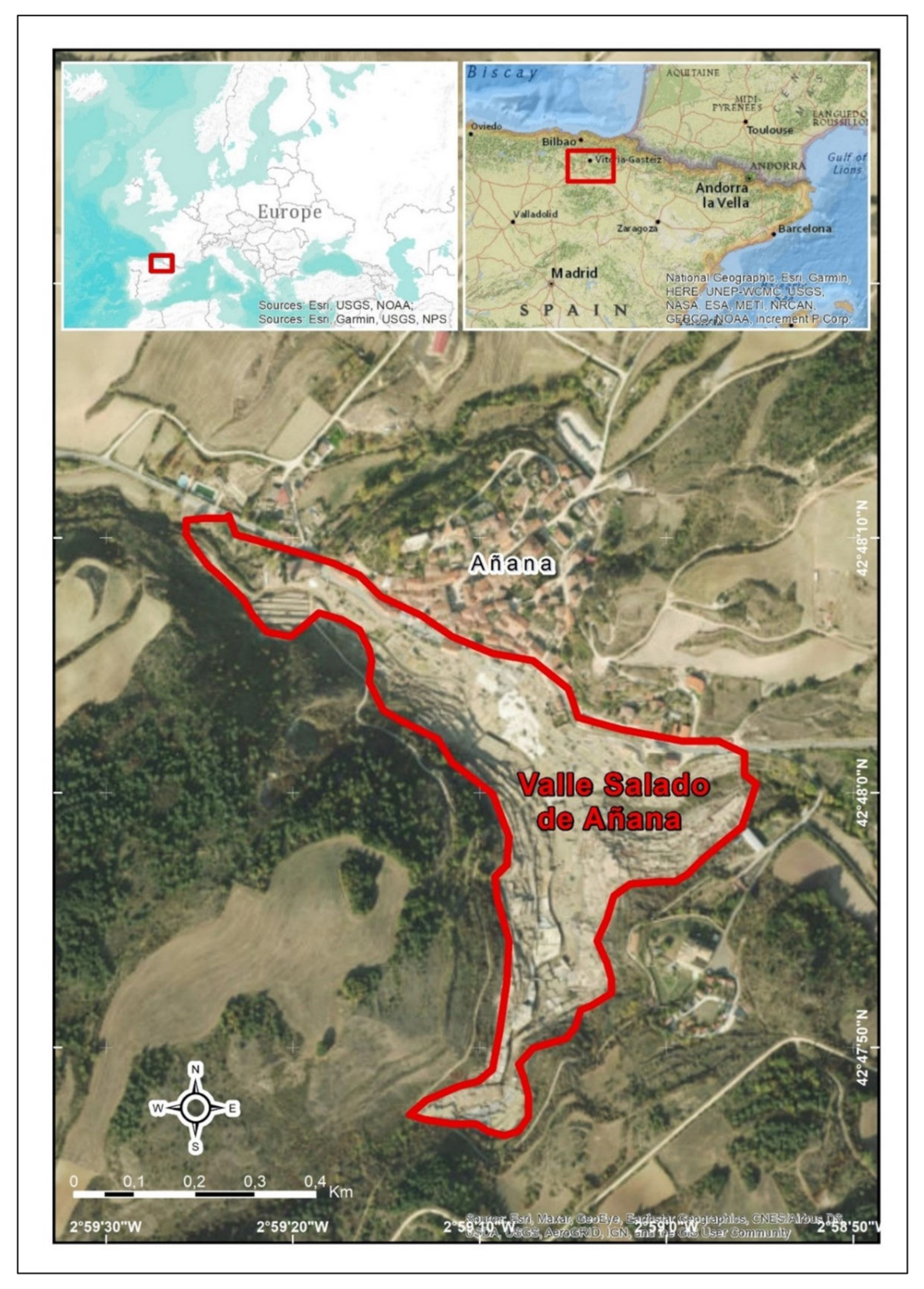
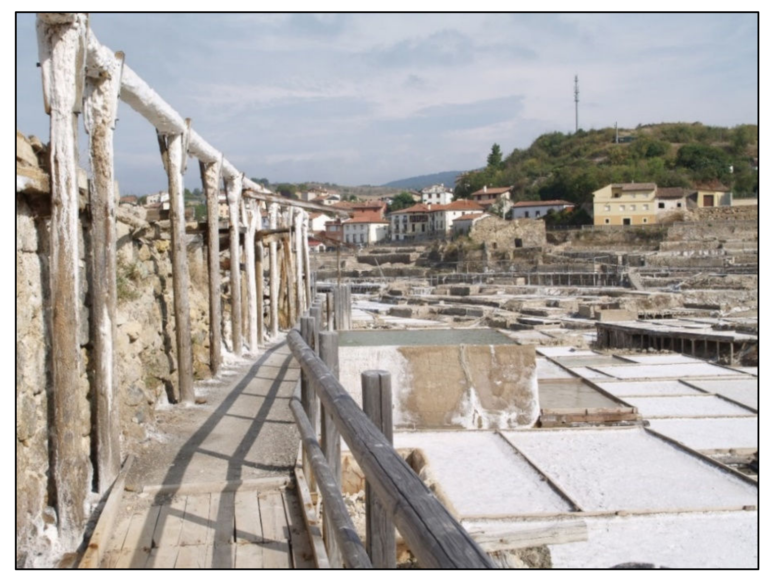
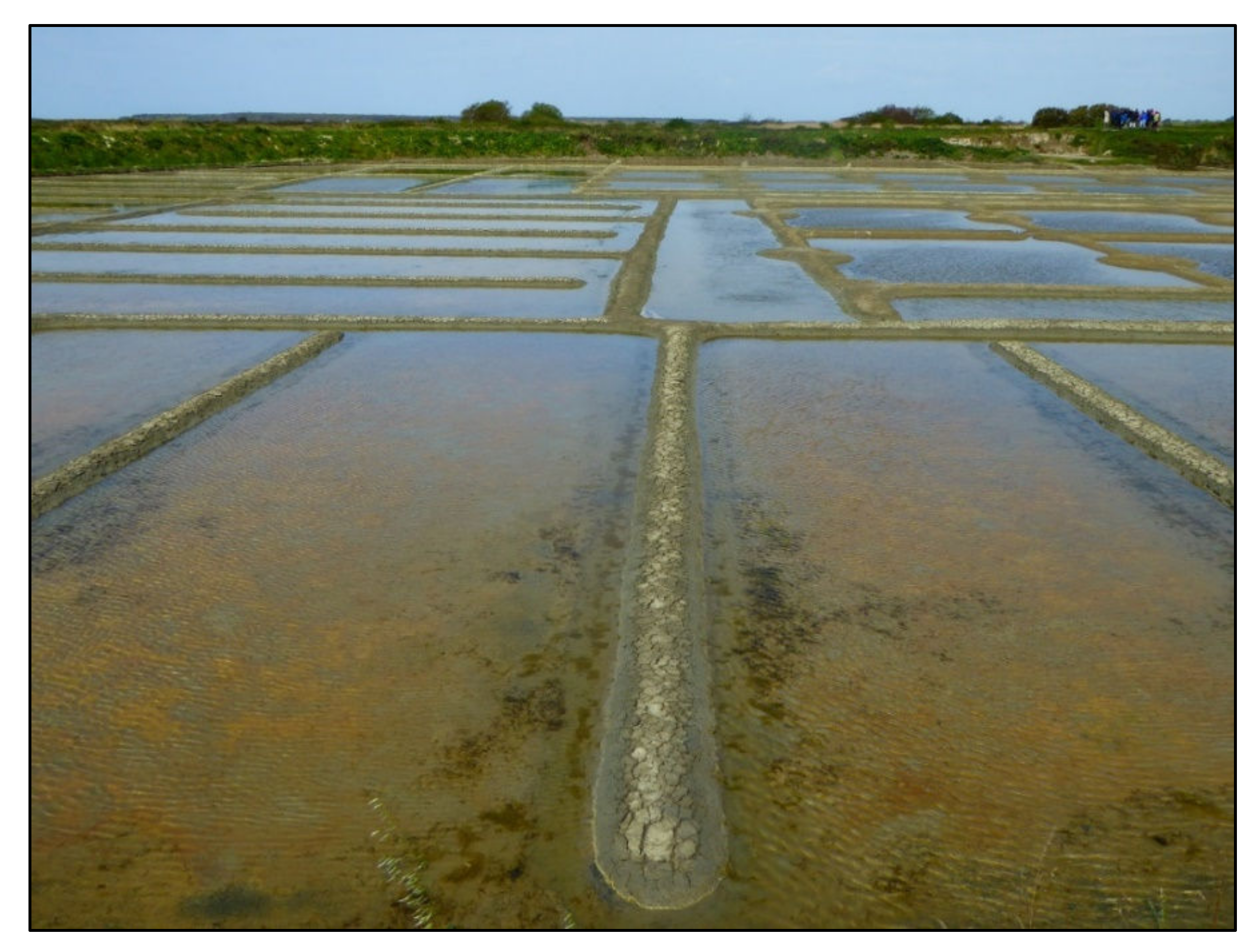
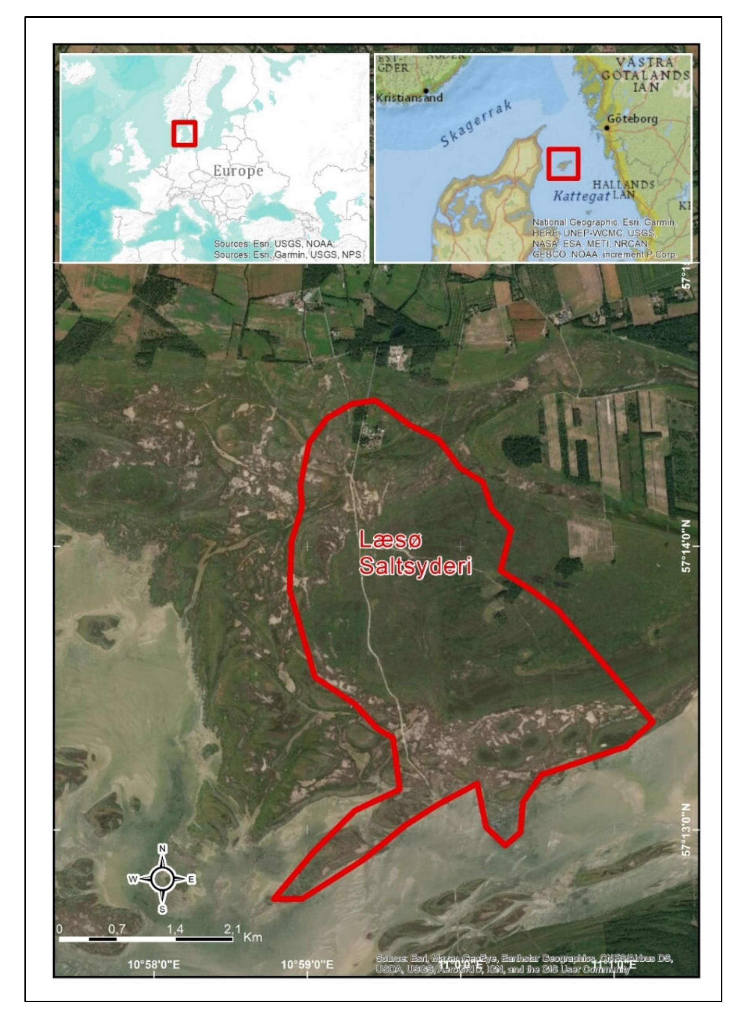
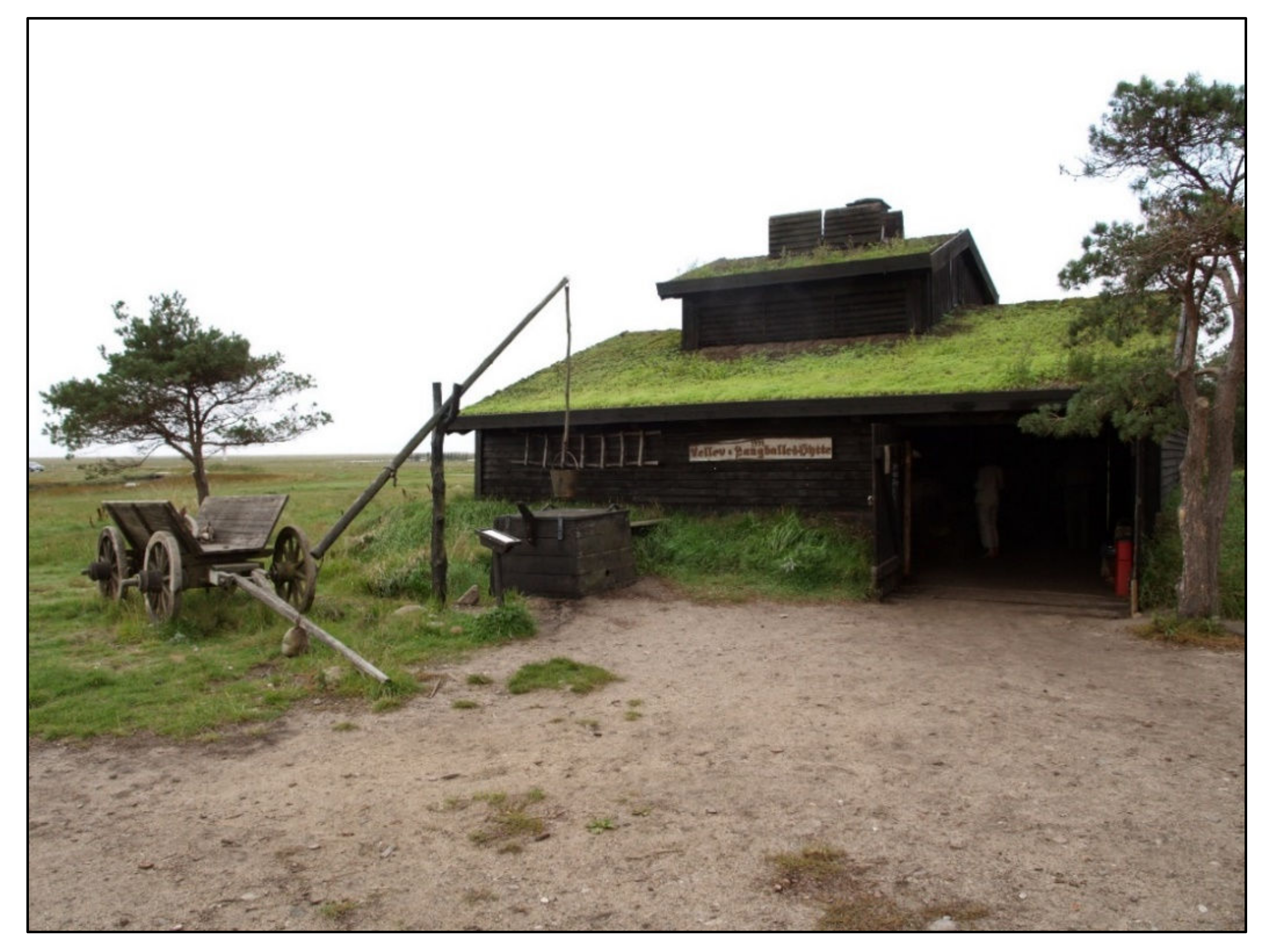
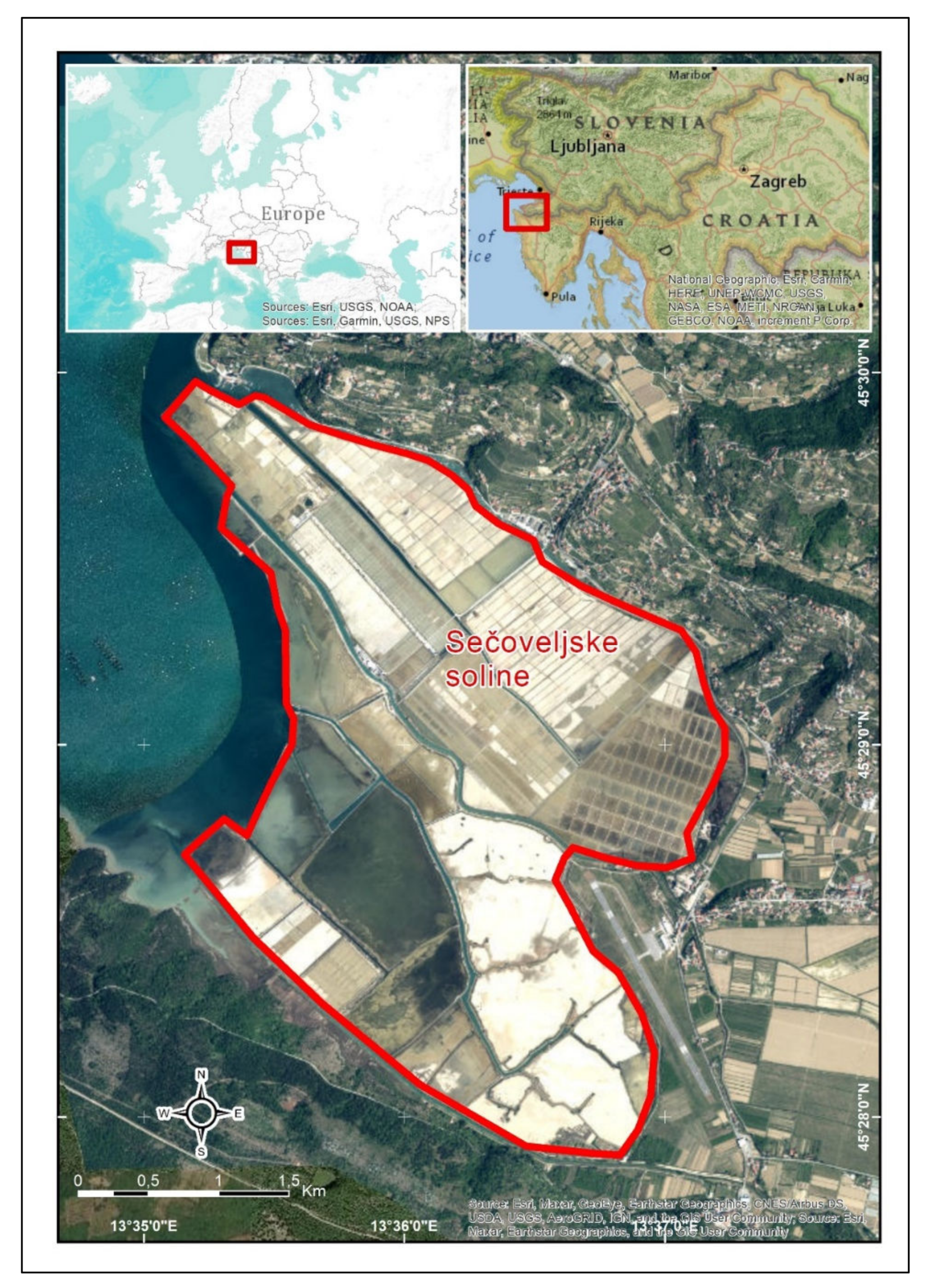
Table 1.
Description of case study sites according to different criteria. Own elaboration.
| Site | Geophysical Features | Productive Features | |||||
|---|---|---|---|---|---|---|---|
| Location | Landscape | Hydrogeol. Origin | Production Method | Energy Source | Scale | State of Facilities | |
| Añana | Inland salina | Mountain | Diapir | Trad. Solar evaporation | Sun & wind | Artisanal | Active |
| Guérande | Coastal salina | Marsh | Sea | Trad. solar evaporation | Sun & wind | Artisanal | Active |
| Læsø | Coastal salina | Marsh | Groundwater (marine intrusion) | Seething | Biomass | Artisanal | Active |
| Sečovlje | Coastal salina | Coast | Sea | Trad. solar evaporation | Sun & wind | Artisanal | Active |
Table 2.
Main features of the four study sites. Own elaboration.
| Site | Patrimonialization Process | Approach | Cause of Change | Owner | Manager | Main Source of Funding |
|---|---|---|---|---|---|---|
| Añana | Institutional | Top down | Abandonment | Private | Public/Private | Public |
| Guérande | Social | Bottom up | Threat of land use change | Private | Coope-rative | Largely private |
| Læsø | Institutional | Bottom up | Historical reconstruction | Private | SME | Private (initially public) |
| Sečovlje | Corporate | Top down | Abandonment/Political change | Public | Large corporate | Largely private |
Table 3.
SWOT analysis of salt heritage and saltscapes.
| Strengths | Weaknesses |
|---|---|
| Structural Salt as a universally known commodity Scenic beauty of saltscapes Visible remains of the salt making activity Appreciation of rural life Managerial Planning and protection instruments Attractive for public investments Sense of belonging Can be recovered to original function | Structural Isolated geographical location Decay and fragility of salt heritage Salt making as a physical challenging activity Seasonality Costly recovery and maintenance Managerial Lack of support for artisanal salt as a product Conflicts in the uses of saltscapes Vandalism |
| Opportunities | Threats |
| Managerial Development of sustainable tourism around saltscapes Potential innovative uses (also R&D) Synergies with other heritage assets and activities Empowerment and motivation of the local community around heritage Flexible financing mechanisms | Managerial Low population density Global economic crisis/pandemic Plans and projects beyond the scope of control Political shortsightedness Dependence on public funds Lack of entrepreneurial culture Climate change |
Publisher’s Note: MDPI stays neutral with regard to jurisdictional claims in published maps and institutional affiliations. |
© 2022 by the authors. Licensee MDPI, Basel, Switzerland. This article is an open access article distributed under the terms and conditions of the Creative Commons Attribution (CC BY) license (https://creativecommons.org/licenses/by/4.0/).
Share and Cite
MDPI and ACS Style
Hueso-Kortekaas, K.; Iranzo-García, E. Salinas and “Saltscape” as a Geological Heritage with a Strong Potential for Tourism and Geoeducation. Geosciences 2022, 12, 141. https://0-doi-org.brum.beds.ac.uk/10.3390/geosciences12030141
AMA Style
Hueso-Kortekaas K, Iranzo-García E. Salinas and “Saltscape” as a Geological Heritage with a Strong Potential for Tourism and Geoeducation. Geosciences. 2022; 12(3):141. https://0-doi-org.brum.beds.ac.uk/10.3390/geosciences12030141
Chicago/Turabian StyleHueso-Kortekaas, Katia, and Emilio Iranzo-García. 2022. "Salinas and “Saltscape” as a Geological Heritage with a Strong Potential for Tourism and Geoeducation" Geosciences 12, no. 3: 141. https://0-doi-org.brum.beds.ac.uk/10.3390/geosciences12030141
Note that from the first issue of 2016, this journal uses article numbers instead of page numbers. See further details here.