
Reconstructing the Fluvial History of the Lilas River (Euboea Island, Central West Aegean Sea) from the Mycenaean Times to the Ottoman Period

 , , , ,
Abstract
:1. Introduction

2. Site Setting
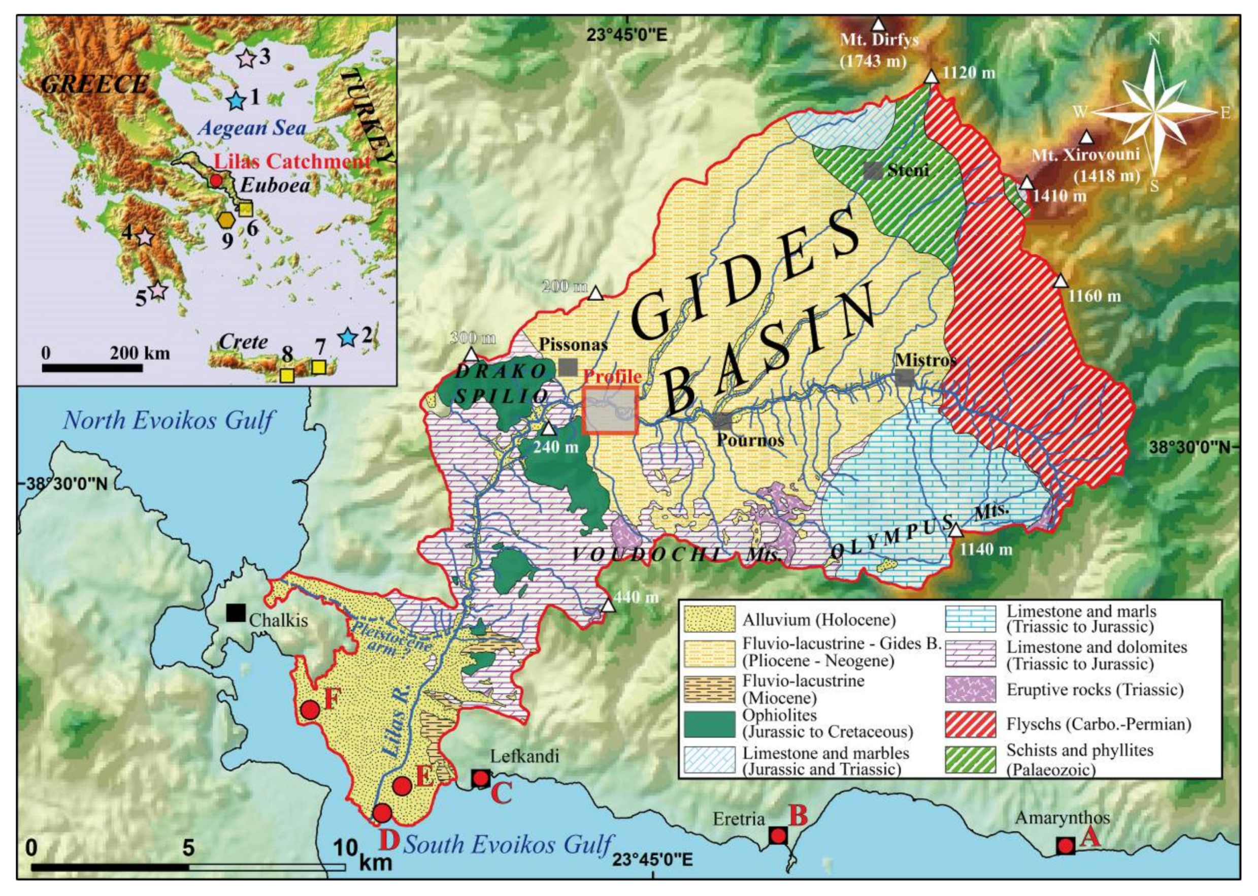
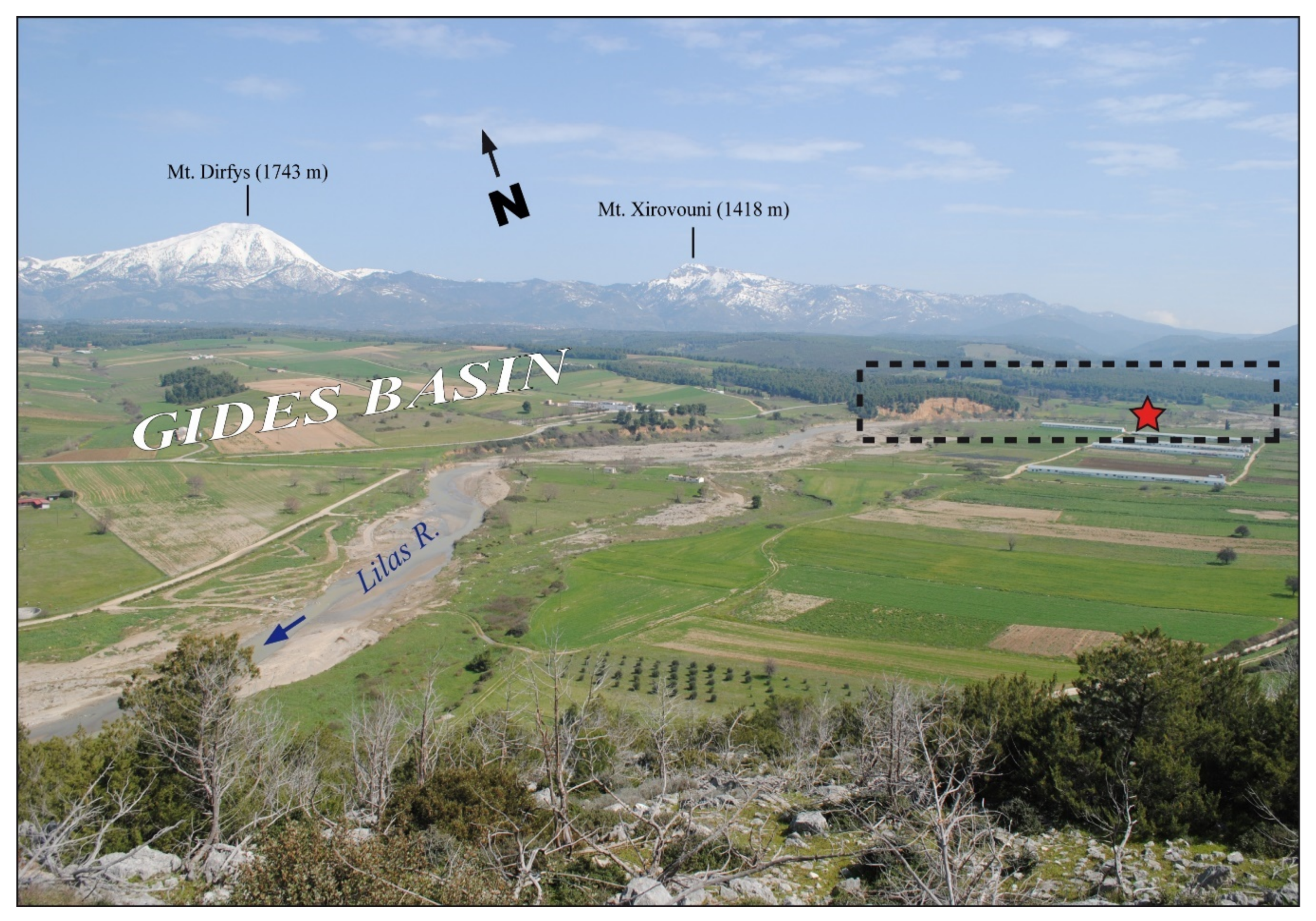
2.1. Topography, Geology and Tectonics
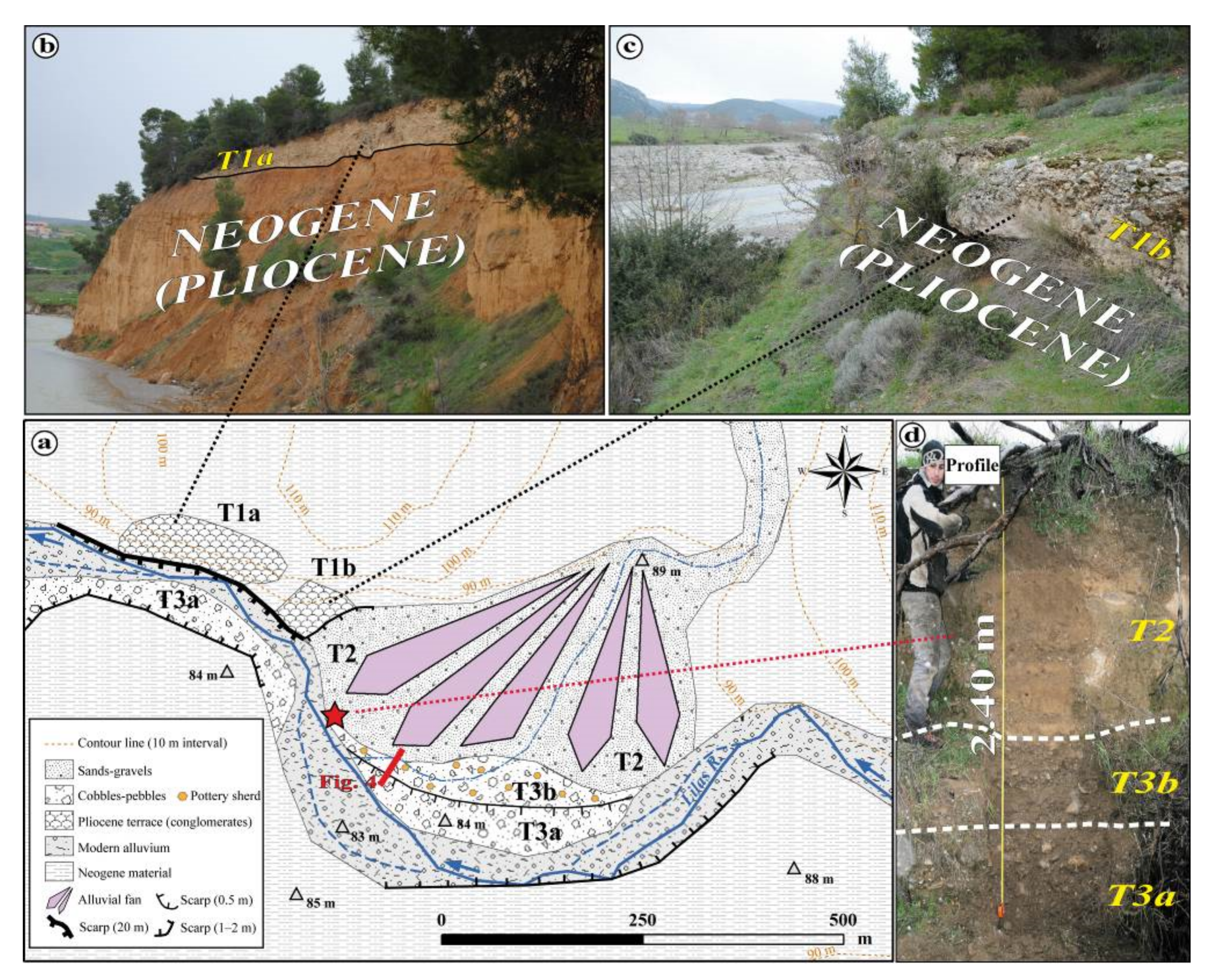
2.2. Alluvial Terraces Geometry
2.3. Archaeological and Historical Background
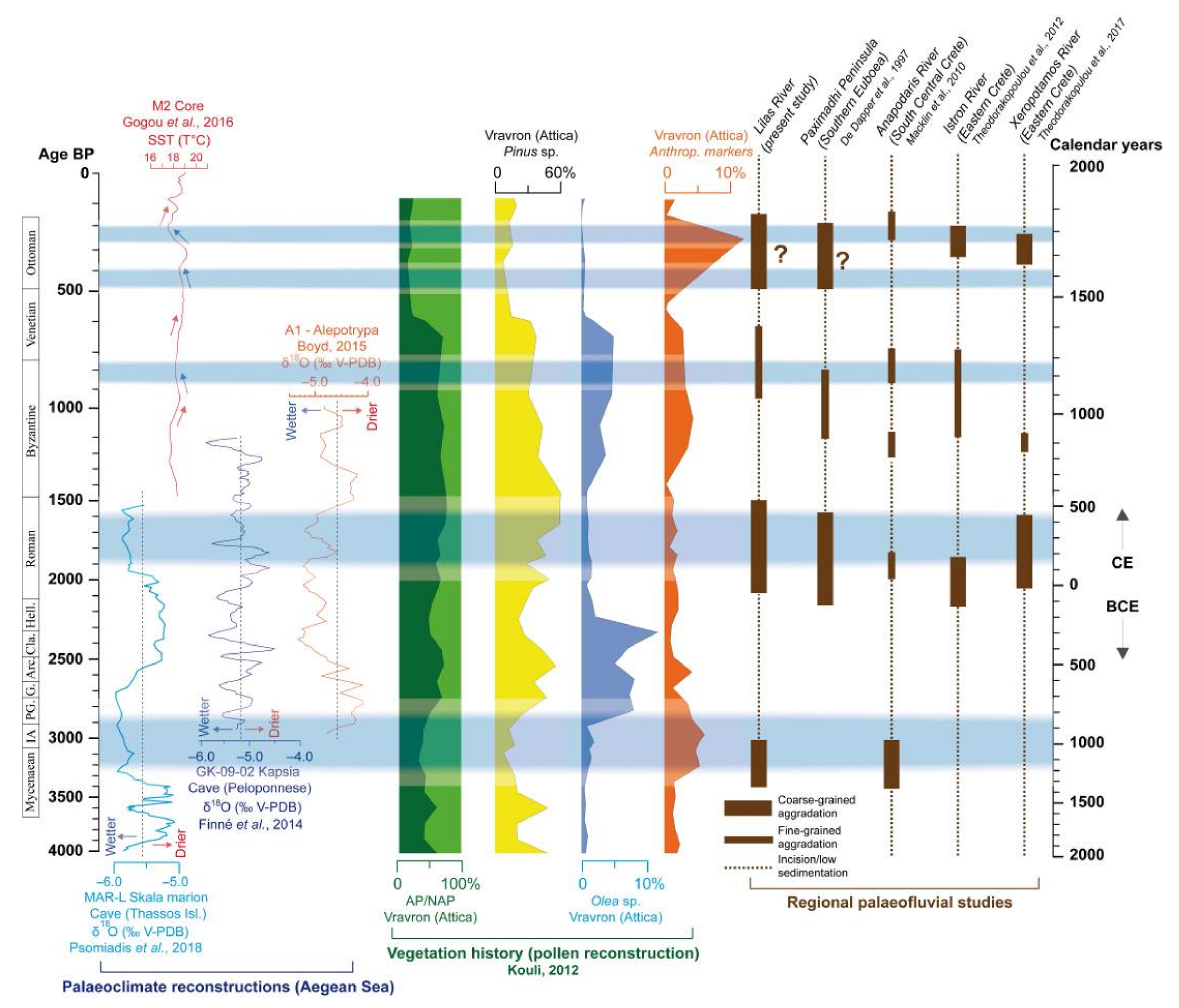
2.4. A Review of the Palaeoclimate and Fluvial Reconstructions Obtained for the Central Aegean Sea Covering the Last Three Millennia
3. Field and Laboratory Methods
3.1. Field Sampling
3.2. Magnetic Susceptibility Measurements
3.3. Grain Size Analyses: Laser Granulometry and Manual Sieving Methods
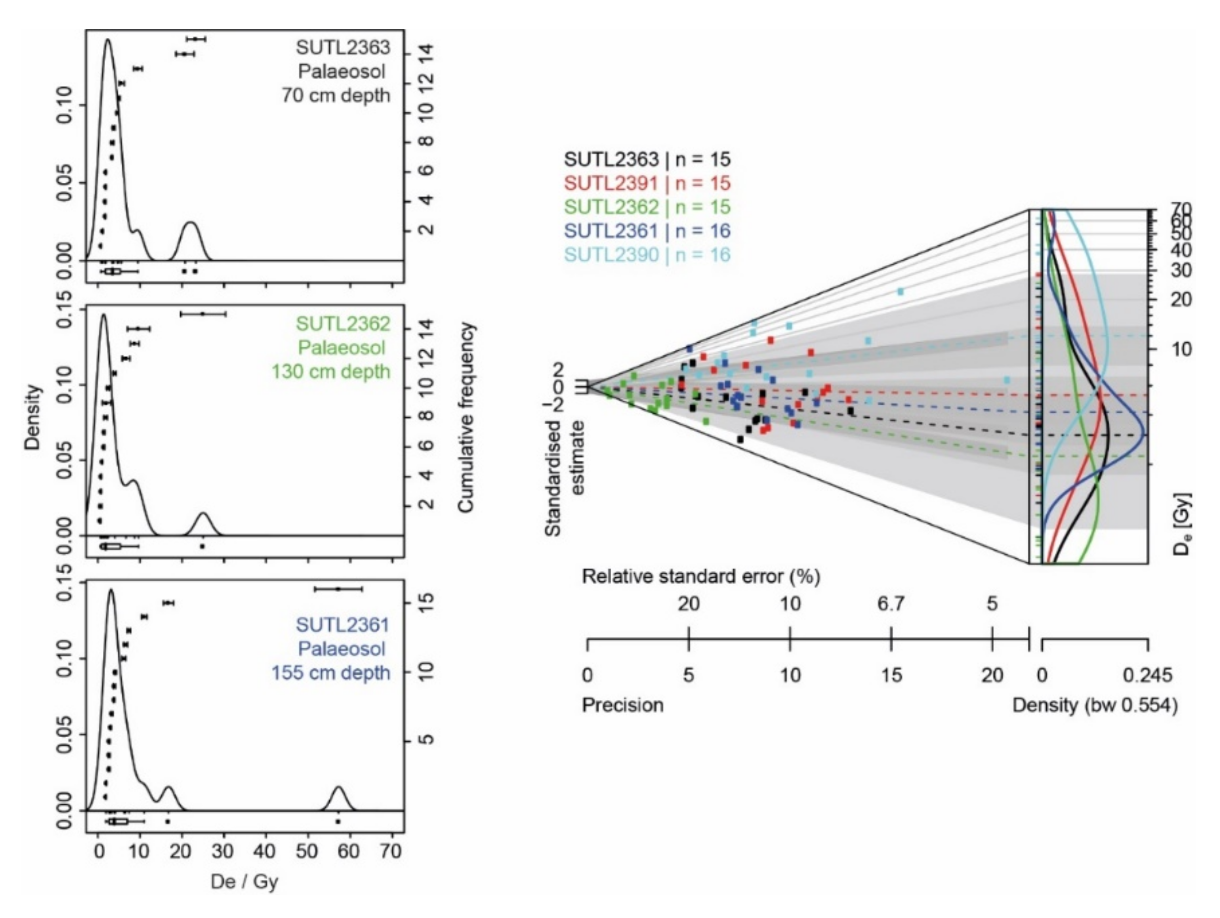
3.4. OSL Profiling and Dating
4. Results
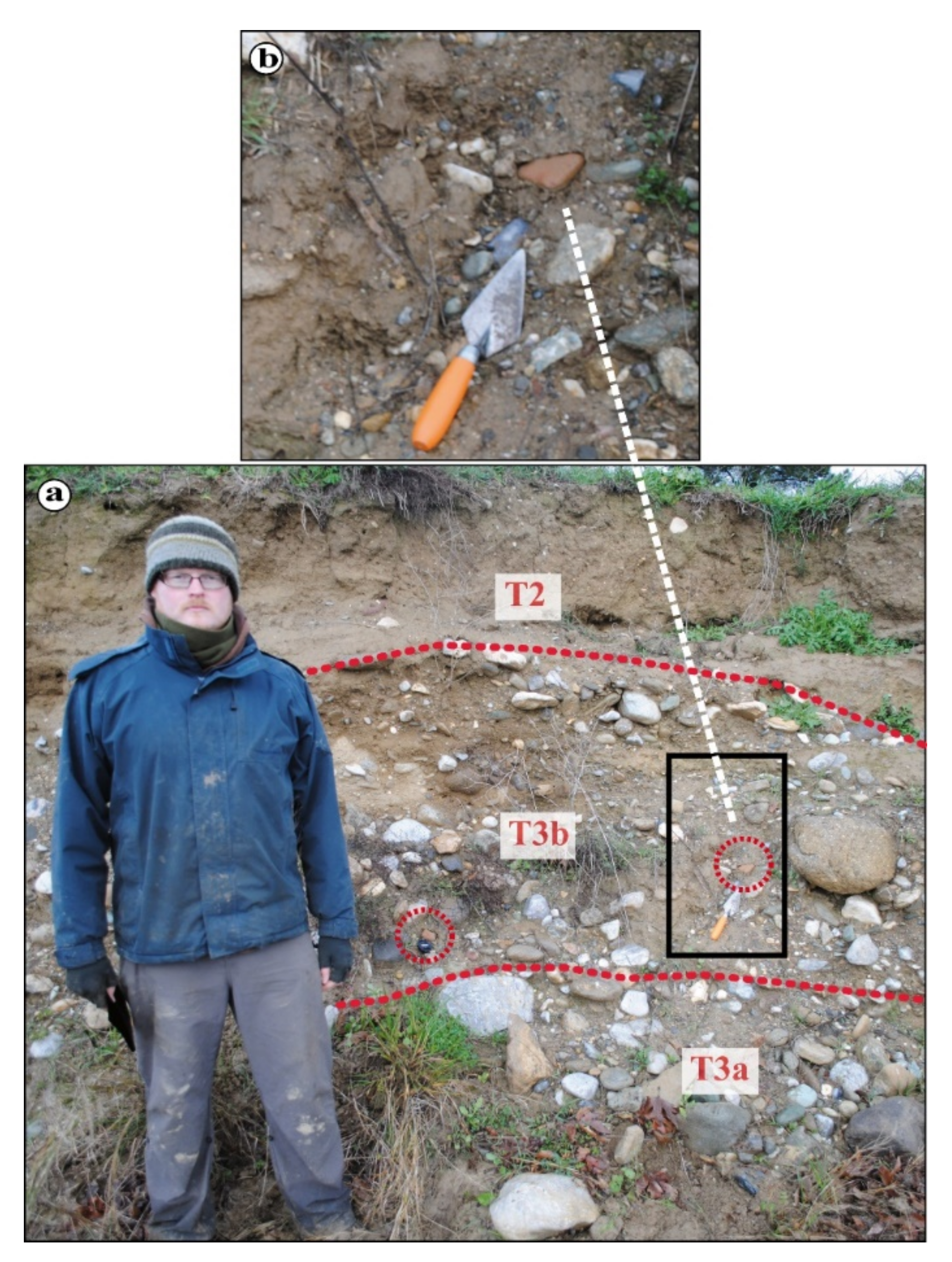
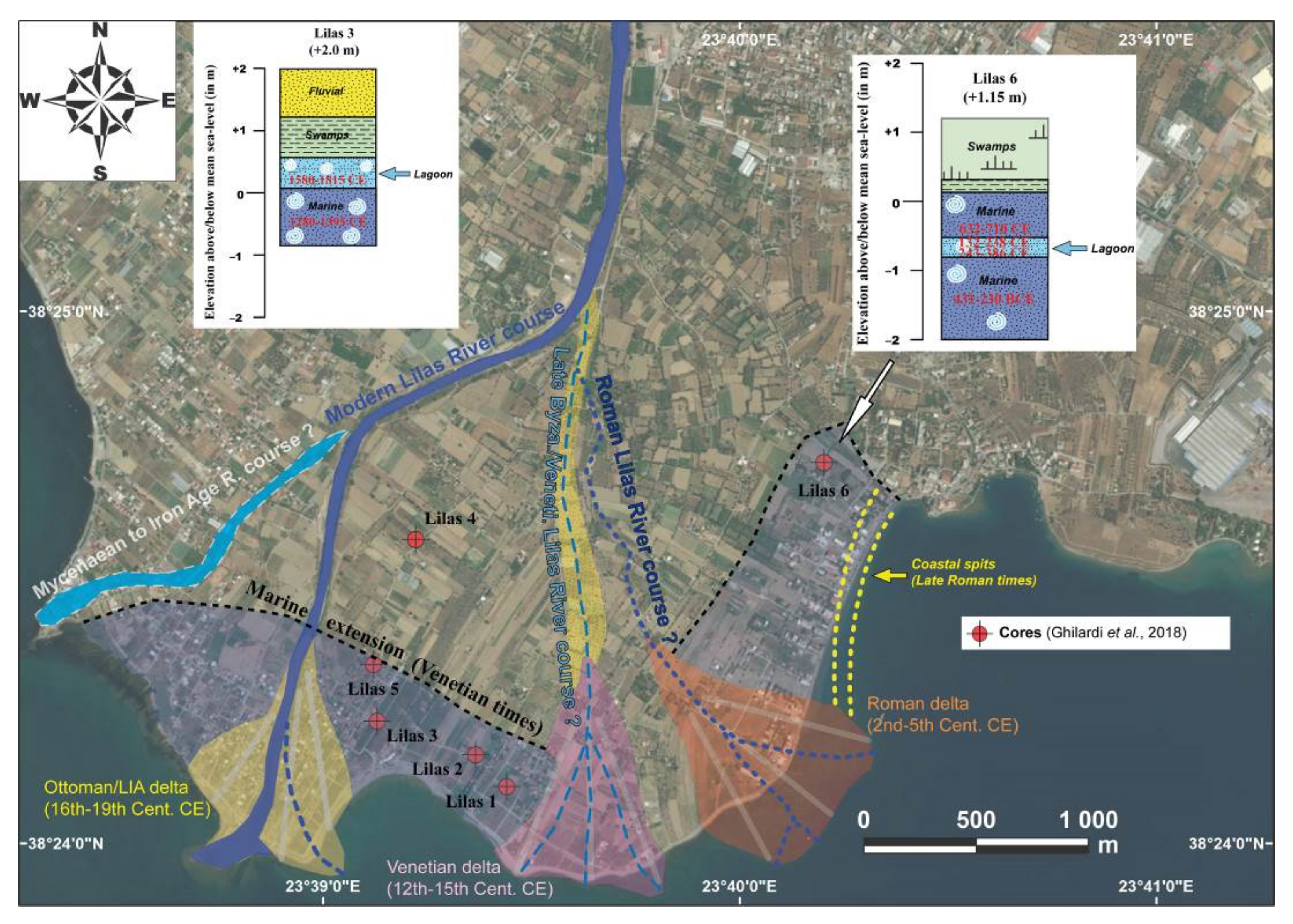
4.1. Lilas Sediment Profile Stratigraphy
4.2. Magnetic Susceptibility Values of the Lilas Catchment Lithologies and Alluvial Sediments
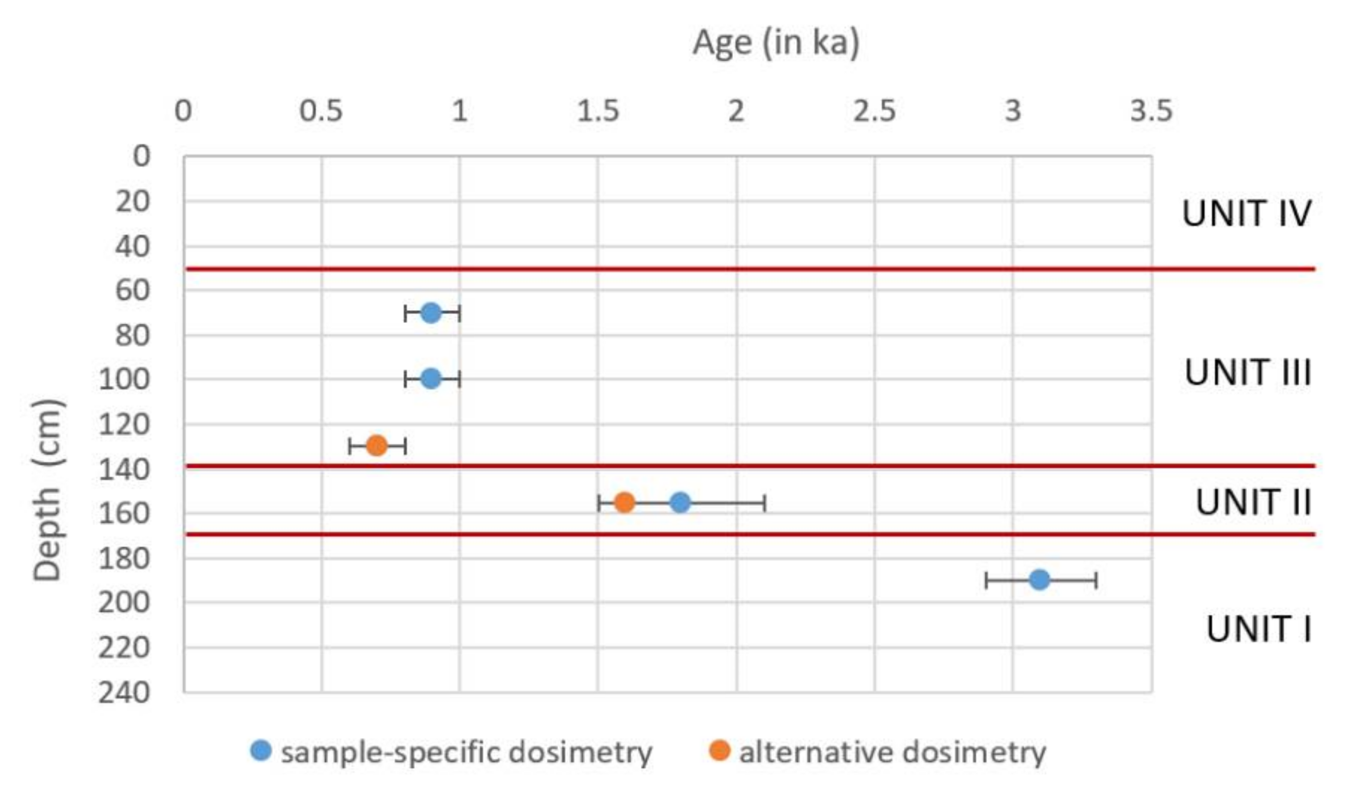
4.3. Dating Results—Geochronology of Alluvial Units
5. Discussion
5.1. Historical Alluviation of the Lilas River and Correlations with Regional Plaeofluvial Studies
5.2. On the Identification of Mycenaean and Roman Coarse-Grained Alluvial Terraces and on the Possible Mixed Climatic/Anthropogenic Origins
5.3. A Late Byzantine (?) to Venetian Fine-Grained Phase of Deposition and Possible Alluvial Activity during the Little Ice Age
5.4. How Can We Explain the Hiatus/Incision Phases Observed during Ancient Greek and Early Byzantine Times?
6. Conclusions
Author Contributions
Funding
Institutional Review Board Statement
Informed Consent Statement
Data Availability Statement
Acknowledgments
Conflicts of Interest
References
- Fouache, E. The Mediterranean World Environment and History; Elsevier Masson: Paris, France, 2003; p. 488. [Google Scholar]
- Vita-Finzi, C. The Mediterranean Valleys: Geological Changes in Historical Times; Cambridge University Press: Cambridge, UK, 1969; p. 140. [Google Scholar]
- Lafrenière, G. The Decline of Nature: Environmental History and the Western Worldview; Academia Press: Cambridge, MA, USA, 2008; p. 457. [Google Scholar]
- Bintliff, J.L. Natural Environment and Human Settlement in Prehistoric Greece Based on Original Fieldwork. BAR Suppl. Ser. 1977, 28, 734. [Google Scholar]
- Bintliff, J.L. Time, Process and Catastrophism in the Study of Mediterranean Alluvial History: A Review. World Archaeol. 2002, 33, 417–435. [Google Scholar] [CrossRef]
- Wagstaff, M. Buried Assumptions: Some Problems in the Interpretation of the “Younger Fill” Raised by Recent Data from Greece. J. Archaeol. Sci. 1981, 8, 247–264. [Google Scholar] [CrossRef]
- Van Andel, T.H.; Zanger, E.; Demitrack, A. Land Use and Soil Erosion in Prehistoric and Historical Greece. J. Field Archaeol. 1990, 17, 379–396. [Google Scholar]
- Lespez, L. Geomorphic Responses to Long-Term Land Use Changes in Eastern Macedonia (Greece). Catena 2003, 51, 181–208. [Google Scholar] [CrossRef]
- Lespez, L. Les Dynamiques des Systèmes Fluviaux en Grèce du Nord au Cours des 7 Derniers Millénaires: Vers une Approche Multiscalaire des Interactions Nature/Société. Géomorphol. Relief Processus Environ. 2007, 1, 49–66. [Google Scholar]
- Dufaure, J.J. La Terrasse Holocène d’Olympie et Ses Équivalents Méditerranéens. Bull. Assoc. Géogr. Fr. 1976, 433–434, 85–94. [Google Scholar] [CrossRef]
- Fouache, E.; Gaki-Papanastassiou, K. Les Crues Brutales dans la Plaine d’Argos (Grèce): Une Contrainte à l'Aménagement, de l'Antiquité à Nos Jours. Géomorphol. Relief Processus Environ. 1997, 3, 313–324. [Google Scholar] [CrossRef]
- Fouache, E. L’Alluvionnement Historique en Grèce Occidentale et au Péloponnèse: Géomorphologie, Archéologie et Histoire. Bull. Corresp. Hell. 1999, 35, 235. [Google Scholar]
- Pope, R.J.J.; Wilkinson, K.N.; Millington, A.C. Human and Climatic Impact on Late Quaternary Deposition in the Sparta Basin Piedmont: Evidence from Alluvial Fan Systems. Geoarchaeology 2003, 18, 685–724. [Google Scholar] [CrossRef]
- Lewin, J.; Macklin, M.J.; Woodward, J.C. Late Quaternary Fluvial Sedimentation in the Voidomatis Basin, Epirus, Northwest Greece. Quat. Res. 1991, 35, 103–115. [Google Scholar] [CrossRef]
- Krahtopoulou, A. Holocene Alluvial History of Northern Pieria, Macedonia, Greece. In Landscape and Land Use in Postglacial Greece; Halstead, P., Frederick, C., Eds.; Sheffield Academic Press: Sheffield, UK, 2000; pp. 15–27. [Google Scholar]
- Lespez, L.; Dalongeville, R.; Noirel-Schutz, C.; Suc, J.-P.; Koukouli-Chryssanthaki, H.; Treuil, R. Les Paléoenvironnements du Site Préhistorique de Dikili Tash (Macédoine Orientale, Grèce). Bull. Corresp. Hell. 2000, 124, 413–434. [Google Scholar] [CrossRef]
- Lespez, L.; Glais, A.; López-Sáez, J.A.; Le Drezen, Y.; Tsirtsoni, Z.; Davidson, R.; Birée, L.; Malamidou, D. Middle Holocene Rapid Environmental Changes and Human Adaptation in Greece. Quat. Res. 2016, 85, 227–244. [Google Scholar] [CrossRef]
- Fuchs, M. An Assessment of Human versus Climatic Impacts on Holocene Soil Erosion in NE Peloponnese, Greece. Quat. Res. 2007, 67, 349–356. [Google Scholar] [CrossRef]
- Macklin, M.G.; Tooth, S.; Brewer, P.A.; Noble, P.L.; Duller, G.A.T. Holocene Flooding and River Development in a Mediterranean Steepland Catchment: The Anapodaris Gorge, South Central Crete, Greece. Glob. Planet. Change 2010, 70, 35–52. [Google Scholar] [CrossRef]
- Theodorakopoulou, K.; Pavlopoulos, K.; Athanassas, K.; Zacharias, N.; Bassiakos, Y. Sedimentological Response to Holocene Climate Events in the Istron Area, Gulf of Mirabello, NE Crete. Quat. Int. 2012, 266, 62–73. [Google Scholar] [CrossRef]
- Theodorakopoulou, K.; Bassiakos, Y. Georchaeological Studies at the Cemetery of Ancient Kamara, Assisted by Optically Stimulated Luminescence (OSL) Dating: Insights in the Post-roman Hydrological Record of Eastern Crete. J. Archaeol. Sci. Rep. 2017, 12, 794–804. [Google Scholar]
- Genre, C. Les Alluvionnements Historiques en Eubée, Grèce. Caractères Principaux, Chronologie, Signification. Études Méditerr. 1988, 12, 229–258. [Google Scholar]
- Genre, C. Néotectonique et Développement des Terrasses de l’Holocène Récent: L’Exemple de l’Eubée (Grèce Centre Orientale). Géomorphol. Relief Processus Environ. 1999, 5, 143–158. [Google Scholar] [CrossRef]
- De Dapper, M.; De Vliegher, B.M.; Peña Monne, J.L. Geoarchaeological Study of Historical Accumulations on the Paximadhi Peninsula (South Euboia, Greece). In Geoarchaeology in Tropical and Mediterranean Regions; Alexandre, J., De Dapper, M., Eds.; Académie Royale des Sciences d’Outre-Mer: Brussels, Belgium, 1997; pp. 91–107. [Google Scholar]
- Wallinga, J. Optically Stimulated Luminescence Dating of Fluvial Deposits: A Review. Boreas 2002, 31, 303–322. [Google Scholar] [CrossRef]
- De Long, S.B.; Arnold, L.J. Dating Alluvial Deposits with Optically Stimulated Luminescence, AMS 14C and Cosmogenic Techniques, Western Transverse Ranges, California, USA. Quat. Geochronol. 2007, 2, 129–136. [Google Scholar] [CrossRef]
- Rittenour, T. Luminescence Dating of Fluvial Deposits: Applications to Geomorphic, Palaeoseismic and Archaeological Research. Boreas 2008, 37, 613–635. [Google Scholar] [CrossRef]
- Cordier, S. Optically Stimulated Luminescence Dating: Procedures and Applications to Geomorphological Research in France. Géomorphol. Relief Processus Environ. 2010, 16, 21–40. [Google Scholar] [CrossRef] [Green Version]
- Wallinga, J.; Bos, I.J. Optical Dating of Fluvio-Deltaic Clastic Lake-Fill Sediments—A Feasibility Study in the Holocene Rhine Delta (Western Netherlands). Quat. Geochronol. 2010, 5, 602–610. [Google Scholar] [CrossRef]
- Genre, C. Cartes des Linéaments Structuraux Établies à Partir des Images Landstat II et des Données Sismotectoniques OASP et IGME; Research Report; CIEM: Poitiers, France, 1985; p. 12. [Google Scholar]
- Ghilardi, M.; Vacchi, M.; Currás, A.; Müller Celka, S.; Theurillat, T.; Lemos, I.; Pavlopoulos, K. Géoarchéologie des Paysages Littoraux le Long du Golfe Sud-Eubéen (île d’Eubée, Grèce) au Cours de l’Holocène. Quaternaire 2018, 29, 95–120. [Google Scholar] [CrossRef]
- Karymbalis, E.; Valkanou, K.; Tsodoulos, I.; Iliopoulos, G.; Tsanakas, K.; Batzakis, V.; Tsironis, G.; Gallousi, C.; Stamoulis, K.; Ioannides, K. Geomorphic Evolution of the Lilas River Fan Delta (Central Evia Island, Greece). Geosciences 2018, 8, 361. [Google Scholar] [CrossRef] [Green Version]
- Gogou, A.; Triantaphyllou, M.; Xoplaki, E.; Izdebski, A.; Parinos, C.; Dimiza, M.D.; Bouloubassi, I.; Luterbacher, J.; Kouli, K.; Martrat, B.; et al. Climate Variability and Socio-Environmental Changes in the Northern Aegean (NE Mediterranean) during the Last 1500 Years. Quat. Sci. Rev. 2016, 136, 209–228. [Google Scholar] [CrossRef]
- Xoplaki, E.; Fleitmann, D.; Luterbacher, J.; Wagner, S.; Haldon, J.F.; Zorita, E.; Telelis, I.; Toreti, A.; Izdebski, A. The Medieval Climate Anomaly and Byzantinum: A Review of the Evidence on Climatic Fluctuations, Economic Performance and Societal Change. Qutaernary Sci. Rev. 2016, 136, 229–252. [Google Scholar] [CrossRef] [Green Version]
- Rohling, E.J.; Mayewski, P.; Abu-Zied, R.; Crasford, J.S.L. Holocene Atmosphere-Ocean Interactions: Records from Greenland and the Aegean Sea. Clim. Dyn. 2002, 18, 587–593. [Google Scholar]
- Psomiadis, D.; Dotsika, E.; Albanakis, K.; Galheb, M.; Hillaire-Marcel, C. Speleothem Record of Climatic Changes in the Northern Aegean Region (Greece) From the Bronze Age to the Collapse of the Roman Empire. Palaeogeogr. Palaeoclimatol. Palaeoecol. 2018, 489, 272–283. [Google Scholar] [CrossRef]
- Finné, M.; Bar-Matthews, M.; Holmgren, K.; Sundqvist, H.S.; Liakopoulos, I.; Zhang, Q. Speleothem Evidence for Late Holocene Climate Variability and Floods in Southern Greece. Quat. Res. 2014, 81, 213–227. [Google Scholar] [CrossRef]
- Boyd, M. Speleothem from Warm Climates-Holocene Records from the Caribbean and Mediterranean Regions. Ph.D. Thesis, Department of Physical Geography, University of Stockholm, Stockholm, Sweden, 2015; p. 82. [Google Scholar]
- Stiros, S.C.; Arnold, M.; Pirazzoli, P.A.; Laborel, J.; Laborel, F.; Papageorgiou, S. Historical Coseismic Uplift on Euboea island, Greece. Earth Planet. Sci. Lett. 1992, 108, 109–117. [Google Scholar] [CrossRef]
- Pavlopoulos, K.; Kapsimalis, V.; Theodorakopoulou, K.; Panagiotopoulos, I.P. Vertical Displacements in the Aegean Coastal Zone (NE Mediterranean) during the Holocene Assessed by Geo-Archaeological Data. Holocene 2011, 22, 717–728. [Google Scholar] [CrossRef]
- Evelpidou, N.; Vassilopoulos, A.; Pirazzoli, A. Holocene Emergence in Euboea Island (Greece). Mar. Geol. 2012, 295–298, 14–19. [Google Scholar] [CrossRef]
- Drakopoulos, I.; Makropoulos, K.; Stavrakakis, G. Junction of Evia–Beotia and Chalkida Diversion. Seismological Study; Report for the Greek Ministry of Public Works; Greek Ministry of Public Works: Athens, Greek, 1984; p. 58. (In Greek)
- Galanopoulos, A. Σεισμική γεωγραφία της Ελλάδος. Ann. Géol. Pays Hell. 1995, VI, 83–121. [Google Scholar]
- Papazachos, B.; Papazachou, C. The Earthquakes of Greece; Ziti Publisher: Thessaloniki, Greece, 1997; p. 304. [Google Scholar]
- Gaki-Papanastassiou, K.; Cundy, A.B.; Maroukian, H. Fluvial versus Tectonic Controls on the Late Holocene Geomorphic and Sedimentary Evolution of a Small Mediterranean Fan Delta System. J. Geol. 2011, 119, 221–234. [Google Scholar] [CrossRef]
- Kalamara, P.; Kosma, M.; Boukaras, K.; Chairetakis, Y. The City of Chalkis; Ministry of Culture and sports; Kapon: Athens, Greece, 2015; pp. 30–51. [Google Scholar]
- Lemos, I.S. The ProtoGeometric Aegean. The archaeology of the Late Eleventh and Tenth Centuries BC.; Oxford University Press: Oxford, UK, 2002; p. 245. [Google Scholar]
- Knodell, A.R. A Conduit Between Two Worlds: Geography and Connectivity in the Euboean Gulf. In An Island Between Two Worlds: The Archaeology of Euboea from Prehistoric to Byzantine Times, Proceedings of International Conference, Eretria, Greece, 12–14 July 2013; Tankosic, Z., Mavridis, F., Kosma, M., Eds.; Norwegian Institute at Athens: Athens, Greece, 2017; pp. 195–213. [Google Scholar]
- Fachard, S.; Verdan, S. Chalkis and Eretria. In The Oxford History of the Archaic Greek World; Cartledge, P., Christesen, P., Eds.; Oxford University Press: Oxford, UK, 2022; Forthcoming. [Google Scholar]
- Sackett, L.H.; Howell, R.J.; Jacobsen, T.W.; Popham, M.R. Prehistoric Euboea: Contributions toward a Survey. ABSA 1966, 61, 33–112. [Google Scholar] [CrossRef]
- Fachard, S. La Défense du Territoire d’Erétrie: Etude de la Chora et de ses Gortifications; Infolio, Eretria, 21; Ecole Suisse d’Archéologie en Grèce: Gollion, Switzerland, 2012; p. 358. [Google Scholar]
- Bakhuizen, S.C. Studies in the Topography of Chalcis on Euboea; Studies of the Dutch Archaeological and Historical Studies; E.J. Brill Publisher: Leiden, The Netherlands, 1985; Volume 11, p. 183. [Google Scholar]
- Loizou, C. The Medieval Towers in the Landscape of Euboea: Landmarks of Feudalism. J. Greek Archaeol. 2016, 1, 331–352. [Google Scholar]
- Koder, J. Negroponte. Untersuchungen zur Topographie und Siedlungsgeschichte der Insel Euboia während der Zeit der Venezianerherrschaft; Verlag der Österreichischen Akadamie der Wissenschaften: Vienna, Austria, 1973; p. 191. [Google Scholar]
- Lock, P. The Towers of Euboea: Lombard or Venetian, Agrarian or Strategic. In The Archaeology of Medieval Greece; Lock, P., Sanders, G.D.R., Eds.; Oxbow: Oxford, UK, 1996; pp. 107–126. [Google Scholar]
- Balta, E. L’Eubée à la Fin du XVe Siècle. Economie et Population. Les Registres de l’Année 1474; Association des Études d’Eubée: Athens, Greece, 1989; p. 448. [Google Scholar]
- Kiel, M. The Turkish Aqueduct of Chalkis. In Studies of the Dutch Archaeological and Historical Studies; E.J. Brill Publisher: Leide, The Netherlands, 1985; Volume 11, pp. 151–157. [Google Scholar]
- Luterbacher, J.; García-Herrera, R.; Akcer-On, S.; Allan, R.; Alvarez-Castro, M.C.; Benito, G.; Booth, J.; Büntgen, U.; Cagatay, N.; Colombaroli, D.; et al. A Review of 2000 Years of Paleoclimatic Evidence in the Mediterranean. In The Climate of the Mediterranean Region; Elsevier: Amsterdam, The Netherlands, 2012; pp. 87–185. [Google Scholar]
- Finné, M.; Woodbridge, J.; Labuhn, I.; Roberts, C.N. Holocene Hydro-Climatic Variability in the Mediterranean: A Synthetic Multi-Proxy Reconstruction. Holocene 2019, 29, 847–863. [Google Scholar] [CrossRef]
- Rohling, E.J.; Marino, G.; Grant, K.M.; Mayewski, P.A.; Weninger, B. A Model for Archaeologically Relevant Holocene Climate Impacts in the Aegean-Levantine Region (Easternmost Mediterranean). Quat. Sci. Rev. 2019, 208, 38–53. [Google Scholar] [CrossRef] [Green Version]
- Kuhnt, T.; Schmiedl, G.; Ehrmann, W.; Hamann, Y.; Hemleben, C. Deep-Sea Ecosystem Variability of the Aegean Sea during the past 22 Kyr as Revealed by Benthic Foraminifera. Mar. Micropaleontol. 2007, 64, 141–162. [Google Scholar] [CrossRef]
- Griggs, C.; De Gaetano, A.; Kuniholm, P.; Newton, M. A Regional High-Frequency Reconstruction of Mayejune Precipitation in the North Aegean from Oak Tree Rings, AD 1089–1989. Int. J. Climatol. 2007, 27, 1075–1089. [Google Scholar] [CrossRef]
- Kotthoff, U.; Müller, U.C.; Pross, J.; Schmiedl, G.; Lawson, I.T.; Van De Schootbrugge, B.; Schulz, H. Lateglacial and Holocene Vegetation Dynamics in the Aegean Region: An Integrated View Based on Pollen Data from Marine and Terrestrial Archives. Holocene 2008, 18, 1019–1032. [Google Scholar] [CrossRef]
- Finné, M.; Holmgren, K.; Shen, C.C.; Hu, H.M.; Boyd, M.; Stocker, S. Late Bronze Age Climate Change and the Destruction of the Mycenaean Palace of Nestor at Pylos. PLoS ONE 2017, 12, e0189447. [Google Scholar] [CrossRef] [Green Version]
- Heymann, C.; Nelle, O.; Dörfler, W.; Zagana, H.; Nowaczyk, N.; Xue, J.; Unkel, I. Late Glacial to Mid-Holocene Palaeoclimate Development of Southern Greece Inferred from the Sediment Sequence of Lake Stymphalia (NE-Peloponnese). Quat. Int. 2013, 302, 42–60. [Google Scholar] [CrossRef]
- Norström, E.; Katrantsiotis, C.; Finné, M.; Risberg, J. Biomarker Hydrogen Isotope Composition (δD) as Proxy for Holocene Hydroclimatic Change and Seismic Activity in SW Peloponnese, Greece. J. Quat. Sci. 2018, 33, 563–574. [Google Scholar] [CrossRef]
- Unkel, I.; Schimmelmann, A.; Shriner, C.; Forsén, J.; Heymann, C.; Brückner, H. The Environmental History of the Last 6500 Years in the Asea Valley (Peloponnese, Greece) And Its Linkage to the Local Archaeological Record. Z Für Geomorphol. 2014, 58, 89–107. [Google Scholar] [CrossRef]
- Bar-Matthews, M.; Ayalon, A.; Kaufman, A. Middle to Late Holocene (6500 years period) Paleoclimate in the Eastern Mediterranean Region from Stable Isotopic Composition of Spe-Leothems from Soreq Cave, Israel. In Water, Environment and Society in Times of Climatic Change; Issar, A.S., Brown, N., Eds.; Kluwer: Amsterdam, The Netherlands, 1998; pp. 203–214. [Google Scholar]
- Bar-Matthews, M.; Ayalon, A.; Gilmour, M.; Matthews, A.; Hawkesworth, C.J. Sea–Land Oxygen Isotopic Relationships from Planktonic Foraminifera and Speleothems in the Eastern Mediterranean Region and Their Implication for Paleorainfall during Interglacial Intervals. Geochim. Cosmochim. Acta 2003, 67, 3181–3199. [Google Scholar] [CrossRef]
- Triantaphyllou, M.; Kouli, K.; Tsourou, T.; Koukousioura, O.; Pavlopoulos, K.; Dermitzakis, M.D. Palaeoenvironmental Changes since 3000 BC in the Coastal Marsh of Vravron (Attica, SE Greece). Quat. Int. 2010, 216, 14–22. [Google Scholar] [CrossRef]
- Ghilardi, M.; Revelles, J.; Glais, A.; Theodorakopoulou, K.; Theodoropoulou, T.; Lespez, L.; Longo, F.; Rossi, A.; Bellier, O.; Benedetti, L. Reconstructing Human-Environment Interactions in the Western Messara Plain (Phaistos, Crete, Greece) From the Emergence of City States to Byzantine Times. J. Archaeol. Sci. Rep. 2019, 26, 101909. [Google Scholar] [CrossRef] [Green Version]
- Kouli, K. Vegetation Development and Human Activities in Attiki (SE Greece) During the Last 5000 Years. Veg. Hist. Archaeobotany 2012, 21, 267–278. [Google Scholar] [CrossRef]
- Bintliff, J.L. Landscape Change in Classical Greece: A Review. In Geoarchaeology of the Landscapes of Classical Antiquity; Vermeulen, F., De Dapper, M., Eds.; Peeters: Leuven, Belgium, 2000; pp. 49–70. [Google Scholar]
- Ehrmann, W.; Schmiedl, G.; Hamann, Y.; Kuhnt, T.; Hemleben, C.; Siebel, W. Clay Minerals in Lateglacial and Holocene Sediments of the Northern and Southern Aegean Sea. Palaeogeogr. Palaeoclimatol. Palaeoecol. 2007, 249, 36–57. [Google Scholar] [CrossRef]
- Orland, I.J.; Bar-Matthews, M.; Kita, N.T.; Ayalon, A.; Matthews, A.; Valley, J.W. Climate Deterioration in the Eastern Mediterranean as Revealed by Ion Microprobe Analysis of a Speleothem That Grew from 2.2 to 0.9 ka in Soreq Cave, Israel. Quat. Res. 2009, 71, 27–35. [Google Scholar] [CrossRef]
- Fouache, E. Un Exemple de Crise d’Alluvionnement Historique: La Terrasse d’Olympie. In Le Commentaire de Paysages en Géographie Physique; Mercier, D., Ed.; SEJER, Armand Colin, Collection U-Géographie: Paris, France, 2004; p. 256. [Google Scholar]
- Cook, B.I.; Anchukaitis, K.J.; Touchan, R.; Meko, D.M.; Cook, E.R. Spatiotemporal Drought Variability in the Mediterranean over the Last 900 Years. J. Geophys. Res. 2016, 121, 2060–2074. [Google Scholar] [CrossRef] [PubMed]
- Maher, B.A.; Taylor, R.M. Formation of Ultrafine-Grained Magnetite in Soils. Nature 1988, 336, 368–370. [Google Scholar] [CrossRef]
- Dearing, J.A.; Dann, R.J.L.; Hay, K.; Lees, J.A.; Loveland, P.J.; Maher, B.A.; O’Grady, K. Frequency-Dependent Susceptibility Measurements of Environmental Materials. Geophys. J. Int. 1996, 124, 228–240. [Google Scholar] [CrossRef] [Green Version]
- Ghilardi, M.; Kunesch, S.; Styllas, M.; Fouache, E. Reconstruction of Mid-Holocene Sedimentary Environments in the Central Part of the Thes-Saloniki Plain (Greece), Based on Microfaunal Identification, Magnetic Susceptibility and Grain-Size Analyses. Geomorphology 2008, 97, 617–630. [Google Scholar] [CrossRef]
- Ghilardi, M.; Cordier, S.; Carozza, J.M.; Psomiadis, D.; Guilaine, J.; Demory, F.; Delanghe-Sabatier, D.; Zomeni, Z.; Vella, M.A.; Bony, G.; et al. The Holocene Fluvial History of the Tremithos River (South Central Cyprus) And Its Linkage to Archaeological Records. Environ. Archaeol. J. Hum. Palaeoecol. 2015, 20, 184–201. [Google Scholar] [CrossRef]
- Ghilardi, M.; Delanghe, D.; Demory, F.; Leandri, F.; Pêche-Quilichini, K.; Vacchi, M.; Vella, M.A.; Rossi, V.; Robresco, S. Enregistrements d’Événements Extrêmes et Évolution des Paysages dans les Basses Vallées Fluviales du Taravo et du Sagone (Corse Occidentale, France) au Cours de l’Âge du Bronze Moyen à Final: Une Perspective Géoarchéologique. Géomorphol. Relief Processus Environ. 2017, 23, 15–35. [Google Scholar] [CrossRef] [Green Version]
- Buurman, P.; Pape, T.; Muggler, C.C. Laser Grain-Size Determination in Soil Genetic Studies: Practical Problems. Soil Sci. 1996, 162, 211–218. [Google Scholar] [CrossRef]
- Buurman, P.; de Boer, K.; Pape, T. Laser Diffraction grain-size characteristics of Andisols in perhumid Costa Rica: The aggregate size of allophane. Geoderma 1997, 78, 71–91. [Google Scholar] [CrossRef]
- Blott, S.J.; Pye, K. Gradistat: A Grain Size Distribution and Statistics Package for the Analysis of Unconsolidated Sediments. Earth Surf. Processes Landf. 2001, 26, 1237–1248. [Google Scholar] [CrossRef]
- Burbidge, C.I.; Sanderson, D.C.W.; Housley, R.A.; Allsworth Jones, P. Survey of Palaeolithic Sites by Luminescence Profiling, a Case Study from Eastern Europe. Quat. Geochronol. 2007, 2, 296–302. [Google Scholar] [CrossRef]
- Kinnaird, T.C.; Sanderson, D.C.W.; Bigelow, G.F. Feldspar SARA IRSL Dating of Very Low Dose Rate Aeolian Sediments from Sandwick South, Unst, Shetland. Quat. Geochronol. 2015, 30, 168–174. [Google Scholar] [CrossRef] [Green Version]
- Kinnaird, T.C.; Sanderson, D.C.W.; Bickett, A. OSL Dating of Fluvial Terrace Deposits, Eubeoa, Greece; Unpublished Report; University of Glasgow: Glasgow, UK, 2011. [Google Scholar]
- Murray, A.S.; Wintle, A.G. Luminescence Dating of Quartz Using an Improved Single-Aliquot Regenerative-Dose Protocol. Radiat. Meas. 2000, 32, 57–73. [Google Scholar] [CrossRef]
- Prescott, J.R.; Hutton, J.T. Cosmic Ray Contributions to Dose Rates for Luminescence and ESR Dating: Large Depths and Long-Term Time Variations. Radiat. Meas. 1994, 23, 497–500. [Google Scholar] [CrossRef]
- Sanderson, D.C.W.; Bishop, P.; Stark, M.; Alexander, S.; Penny, D. Luminescence Dating of Canal Sediments from Angkor Borei, Mekong Delta, Southern Cambodia. Quat. Geochronol. 2007, 2, 322–329. [Google Scholar] [CrossRef]
- Fuchs, M.; Lang, A. OSL Dating of Coarse-Grain Fluvial Quartz Using Single-Aliquot Protocols on Sediments from NE Peloponnese, Greece. Quat. Sci. Rev. 2001, 20, 783–787. [Google Scholar] [CrossRef]
- Lepper, K.; Larsen, N.A.; McKeever, S.W.S. Equivalent Dose Distribution Analysis of Holocene Eolian and Fluvial Quartz Sandsequivalent Dose Distribution Analysis of Holocene Eolian and Fluvial Quartz Sands from Central Oklahoma. Radiat. Meas. 2000, 32, 603–608. [Google Scholar] [CrossRef]
- Olley, J.M.; Caitcheon, G.G.; Murray, A.S. The Distribution of Apparent Dose as Determined by Optically Stimulated Luminescence in Small Aliquots of Fluvial Quartz: Implications for Dating Young Sediment. Quat. Geochronol. 1998, 17, 1033–1040. [Google Scholar]
- Olley, J.M.; Caitcheon, G.G.; Roberts, R.G. The Origin of Dose Distributions in Fluvial Sediments, and the Prospect of Dating Single Grains from Fluvial Deposits Using Optically Stimulated Luminescence. Radiat. Meas. 1999, 30, 207–217. [Google Scholar] [CrossRef]
- Sanderson, D.C.W. Thermoluminescence Dating of Vitrified Scottish Forts. Ph.D. Thesis, Paisley College, Paisley, UK, 1987. [Google Scholar]
- Aitken, M.J. Dose Rate Data in SI Units. PACT 1983, 9, 69–73. [Google Scholar]
- Bell, W.T.; Zimmerman, D.W. The Effect of HF Acid Etching on the Morphology of Quartz Inclusions for Thermoluminscence Dating. Archaeometry 1978, 20, 63–65. [Google Scholar] [CrossRef]
- Ghilardi, M.; Psomiadis, D.; Pavlopoulos, K.; Müller-Celka, S.; Fachard, S.; Theurillat, T.; Verdan, S.; Knodell, A.; Theodoropoulou, T.; Bicket, A.; et al. Mid- to Late Holocene Shoreline Reconstruction and Human Occupation in Ancient Eretria (South Central Euboea, Greece). Geomorphology 2014, 208, 225–237. [Google Scholar] [CrossRef]
- Krause, K. Naissance et Formation d’une Ville. Hist. Archéol. Doss. 1985, 94, 17–25. [Google Scholar]
- Fachard, S.; Theurillat, T.; Psalti, A.; Ackermann, D.; Knoepfler, D. La Nécropole du Canal à Érétrie: Topographie et Inscriptions. Bull. Corresp. Hell. 2017, 141, 141–226. [Google Scholar] [CrossRef] [Green Version]
- Verdan, S.; Theurillat, T.; Fachard, S.; Ghilardi, M. Of Dykes and Men: Eretria in the Making. In Opere di Regimentazione delle Acque in Età Arcaica, Roma, Grecia e Magna Grecia, Etruria et Mondo Italico; Bianchi, E., D’Acunto, M., Eds.; Edizioni Quasar: Rome, Italy, 2020; pp. 19–36. [Google Scholar]
- Ghilardi, M.; Fachard, S.; Pavlopoulos, K.; Psomiadis, D.; Collana, C.; Bicket, A.; Crest, Y.; Bonneau, A.; Delanghe-Sabatier, D.; Knodel, A.; et al. Reconstructing Mid-to-Recent Holocene Paleoenvironments in the Vicinity of Ancient AMA-Rynthos (Euboea, Greece). Geodin. Acta 2012, 25, 38–51. [Google Scholar] [CrossRef] [Green Version]
- Moody, J. Holocene Climate Change in Crete: An Archaeologist’s View. In Landscape and Land Use in Postglacial Greece. Sheffield Studies in Aegean Archaeology, 3; Halstead, P., Frederick, C., Eds.; Sheffield Academic Press: Sheffield, UK, 2000; pp. 52–61. [Google Scholar]
- Lemos, I.S. Euboea and Its Aegean Koine. In Euboica: L’Eubea e la Presenza Euboica in Calcidica e in Occidente; D’Agostino, B., Bats, M., Eds.; Centre Jean Bérard: Naples, Italy, 1998; pp. 45–58. [Google Scholar]
- Kouli, K.; Triantaphyllou, M.; Pavlopoulos, K.; Tsourou, T.; Karkanas, P.; Dermitzakis, M.D. Palynological Investigation of Holocene Palaeoenvironmental Changes in the Coastal Plain of Marathon (Attica, Greece). Geobios 2009, 42, 43–51. [Google Scholar] [CrossRef]
- Kvapil, L. The Agricultural Terraces of Korphos-Kalamianos: A Case Study of the Dynamic Relationship Between Land Use and Socio-Political Organization in Prehistoric Greece. Ph.D. Thesis, University of Cincinnati, Cincinnati, OH, USA, 2012. [Google Scholar]
- Zangger, E. Landscape Changes around Tiryns During the Bronze Age. Am. J. Archaeol. 1994, 98, 189–212. [Google Scholar] [CrossRef]
- Palaiologou, H. The Plain of Mycenae During the 13th Century BC and Later. In Physis: Environnement Naturel et la Relation Homme-milieu dans le Monde Égéen Protohistorique, Proceeding of the Actes de la 14e Rencontre Égéenne International, Paris, France, 11–14 December 2012; Touchais, G., Laffineur, R., Rougemont, F., Eds.; Leuven: Leuven, Belgium, 2014; Volume 34, pp. 517–519. [Google Scholar]
- Maroukian, H.; Gaki-Papanastassiou, K.; Papanastassiou, D. Geomorphic and Seismotectonic Observations in the Area of Mycenae, Their Relation to the Catastrophes of Mycenae during Mycenaean Times. In Archaeoseismology; British School of Archaeology at Athens: Athens, Greece, 1996; pp. 189–194. [Google Scholar]
- Zangger, E.; Timpson, M.E.; Yazvenko, S.B.; Kuhnke, F.; Knauss, J. The Pylos Regional Archaeological Project: Part II: Landscape Evolution and Site Preservation. Hesperia J. Am. Sch. Class. Stud. Athens 1997, 66, 549–641. [Google Scholar] [CrossRef]
- Weiberg, E.; Bevan, A.; Kouli, K.; Katsianis, M.; Woodbridge, J.; Bonnier, A.; Engel, M.; Finné, M.; Fyfe, R.; Maniatis, Y.; et al. Long-Term Trends of Land Use and Demography in Greece: A Comparative Study. Holocene 2019, 29, 742–760. [Google Scholar] [CrossRef] [Green Version]
- Emmanouilidis, A.; Panagiotopoulos, K.; Kouli, K.; Avramidis, P. Late-Holocene Paleoenvironmental and Land-Use Changes in Western Greece Based on a Sediment Record from Klisova Lagoon. Holocene 2022, 32, 485–500. [Google Scholar] [CrossRef]
- Loizou, C. The Medieval Towers of Euboea: Their Dimension as Domestic and Landscape Phenomena. In An Island between Two Worlds. The Archaeology of Euboea from Prehistoric to Byzantine Times; Tankosic, Z., Mavridis, F., Kosma, M., Eds.; Norwegian Institute at Athens: Athens, Greece, 2017; Volume 6, pp. 625–638. [Google Scholar]
- Dimiza, M.D.; Fatourou, M.; Arabas, A.; Panafiotopoulos, I.; Gogou, A.; Kouli, K.; Parinos, C.; Rousakis, G.; Triantaphyllou, M.V. Deep-Sea Benthic Foraminifera Record of the Last 1500 Years in the North Aegean Trough (Northeastern Mediterranean): A Paleoclimatic Reconstruction Scenario. Deep.-Sea Res. Part II 2020, 171, 104705. [Google Scholar] [CrossRef]
- Bond, G.; Showers, W.; Cheseby, M.; Lotti, R.; Almasi, P.; deMenocal, P.; Priore, P.; Cullen, H.; Hajdas, I.; Bonani, G. A Pervasive Millennial-Scale Cycle in North Atlantic Holocene and Glacial Climates. Science 1997, 278, 1257–1266. [Google Scholar] [CrossRef]
- Weiberg, E.; Unkel, I.; Kouli, K.; Holmgren, K.; Avramidis, P.; Bonnier, A.; Dibble, F.; Finné, M.; Izdebski, A.; Katrabtsiotis, C.; et al. The Socio-Environmental History of the Peloponnese during the Holocene: Towards an Integrated Understanding of the Past. Quat. Sci. Rev. 2016, 136, 40–65. [Google Scholar] [CrossRef] [Green Version]


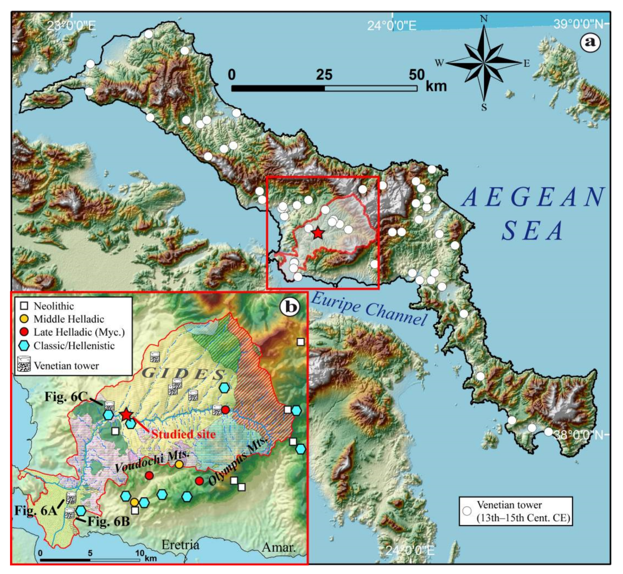
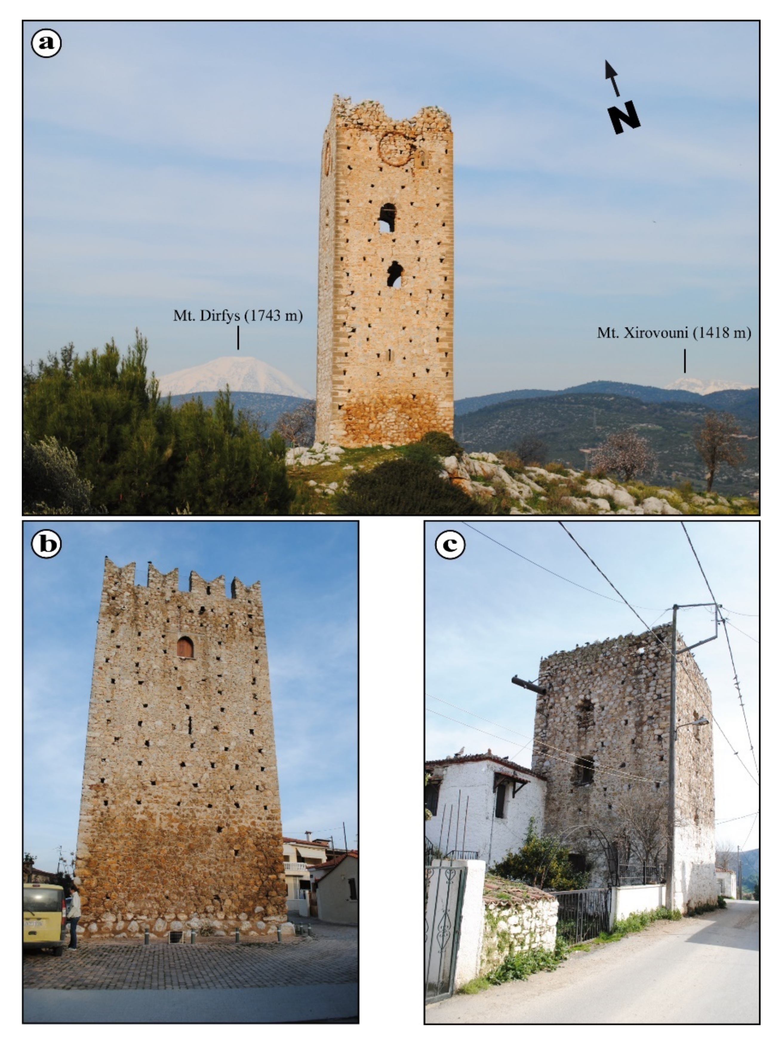
| Terrace Level | Sedimentary Unit | Granulometry | Magnetic Susceptibility | OSL Dating | Archaeological Material |
|---|---|---|---|---|---|
| T2 | Unit IV | Manual sieving + LASER | Yes | No | No |
| Unit III | Manual sieving + LASER | Yes | Yes | No | |
| T3b | Unit II | Manual sieving | Yes | Yes | Yes |
| T3a | Unit I | Manual sieving + LASER | Yes | Yes | No |
| SUERC Code | Field Number | Depth in Section (m) | Sedimentary Unit (Terrace Level) | Description |
|---|---|---|---|---|
| SUTL 2363 | Lilas6 | 70 | Unit III (Terrace T2) | Palaeosol P4 |
| SUTL 2391 | Lilas5 | 100 | Unit III (Terrace T2) | Silty sands/palaeosol P3 |
| SUTL 2362 | Lilas4 | 130 | Unit III (Terrace T2) | Palaeosol P2 |
| SUTL 2361 | Lilas2 | 155 | Unit II (Terrace T3b) | Silts/fine-grained sands; brown to yellow/Palaeosol P1 |
| SUTL 2390 | Lilas 1 | 190 | Unit I (Terrace T3a) | Silts to sands |
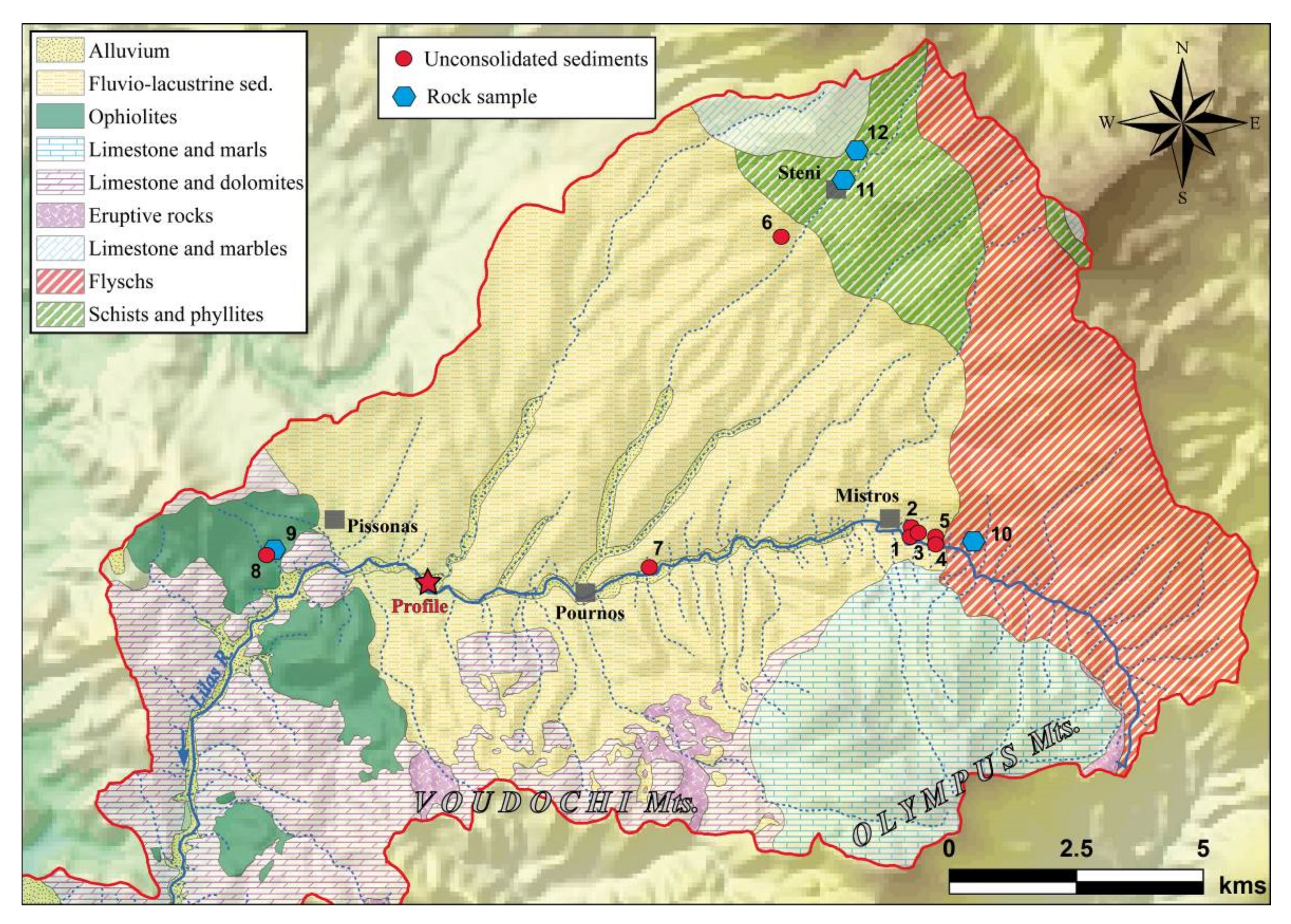
| Material | Site Reference (Figure 7) | Area | Texture/Geology/Environment | χlf (×10−8m3⋅kg−1) | χfd (%) |
|---|---|---|---|---|---|
| Unconsolidated sediments | 1 | Mistros (upper reaches) | Alluvial sands to gravels | 11.6 | 4.2 |
| 2 | Mistros (upper reaches) | Alluvial sands | 32.6 | 4.9 | |
| 3 | Mistros (upper reaches) | Alluvial sands to gravels | 42.9 | 3.7 | |
| 4 | Mistros (upper reaches) | Sands to gravels (Alluvial terrace) | 40.9 | 4.8 | |
| 5 | Mistros (upper reaches) | Sands (Alluvial terrace) | 28.4 | 6.3 | |
| 6 | Steni (upper reaches) | Clays to fine sands | 10.7 | 4.7 | |
| 7 | Pournos (mid-stream) | Terra Rossa (red soils) | 244.1 | 13.2 | |
| 8 | Pissonas (mid-stream) | Oxidised clays and sands (above ophiolitic bedrock) | 1071.2 | 1.5 | |
| Rock sample | 9 | Pissonas (mid-stream) | Ophiolite | 793.6 | 1.1 |
| 10 | Mistros (upper reaches) | Flyschs | 11.3 | 1.7 | |
| 11 | Steni (upper reaches) | Phyllites | 10.1 | 2.8 | |
| 12 | Steni (upper reaches) | Limestone | 11.3 | 2.1 |
| Sample ID | Depth/cm | Dose Rate/mGy a−1 | Stored Dose/Gy | Age/ka | Age/Calendar Years | Sedimentary Unit (SU)/Terrace Level (Section 4.1) |
|---|---|---|---|---|---|---|
| 2363 | 70 | 3.40 ± 0.12 | 2.9 ± 0.5 | 0.9 ± 0.1 | 1150 ± 140 CE | Top of SU III/Terrace T2 |
| 2391 | 100 | 2.61 ± 0.13 | 2.4 ± 0.1 | 0.9 ± 0.1 | 1100 ± 50 CE | Mid of SU III/Terrace T2 |
| 2362 | 130 | 2.59 ± 0.17 | 1.8 ± 0.4 | 0.7 ± 0.1 | 1320 ± 140 CE | Base of SU III/Terrace T2 |
| 2361 | 155 | 2.31 ± 0.21 | 3.8 ± 0.5 | 1.6 ± 0.3 | 360 ± 260 CE | Base of SU II/Terrace T3b |
| 2390 | 190 | 2.05 ± 0.13 | 6.4 ± 0.2 | 3.1 ± 0.2 | 1110 ± 220 BCE | Top of SU I/Terrace T3a |
Publisher’s Note: MDPI stays neutral with regard to jurisdictional claims in published maps and institutional affiliations. |
© 2022 by the authors. Licensee MDPI, Basel, Switzerland. This article is an open access article distributed under the terms and conditions of the Creative Commons Attribution (CC BY) license (https://creativecommons.org/licenses/by/4.0/).
Share and Cite
Ghilardi, M.; Kinnaird, T.; Kouli, K.; Bicket, A.; Crest, Y.; Demory, F.; Delanghe, D.; Fachard, S.; Sanderson, D. Reconstructing the Fluvial History of the Lilas River (Euboea Island, Central West Aegean Sea) from the Mycenaean Times to the Ottoman Period. Geosciences 2022, 12, 204. https://0-doi-org.brum.beds.ac.uk/10.3390/geosciences12050204
Ghilardi M, Kinnaird T, Kouli K, Bicket A, Crest Y, Demory F, Delanghe D, Fachard S, Sanderson D. Reconstructing the Fluvial History of the Lilas River (Euboea Island, Central West Aegean Sea) from the Mycenaean Times to the Ottoman Period. Geosciences. 2022; 12(5):204. https://0-doi-org.brum.beds.ac.uk/10.3390/geosciences12050204
Chicago/Turabian StyleGhilardi, Matthieu, Tim Kinnaird, Katerina Kouli, Andrew Bicket, Yannick Crest, François Demory, Doriane Delanghe, Sylvian Fachard, and David Sanderson. 2022. "Reconstructing the Fluvial History of the Lilas River (Euboea Island, Central West Aegean Sea) from the Mycenaean Times to the Ottoman Period" Geosciences 12, no. 5: 204. https://0-doi-org.brum.beds.ac.uk/10.3390/geosciences12050204