
Soil Characteristics in Private Gardens of Different City Neighborhoods: A Case Study of Taibe, Israel

Abstract
:1. Introduction
2. Materials and Methods
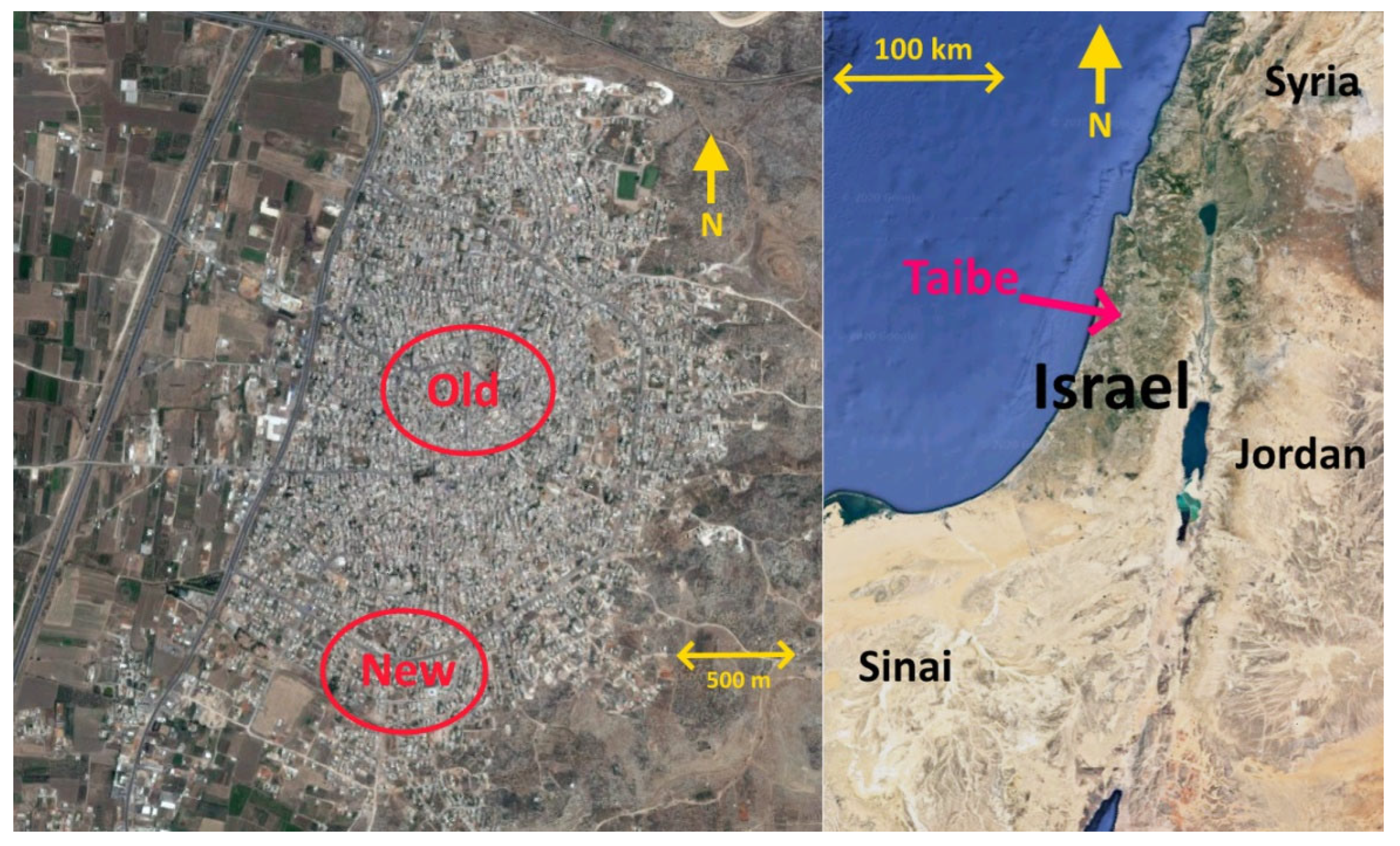
2.1. Study Area
2.2. Field Work
2.3. Laboratory Methods
2.4. Statistical Analysis
3. Results
4. Discussion
4.1. Differences between the City Neighborhoods
4.2. Soil Properties Gradients
4.3. Urban Soil Development
5. Conclusions
Author Contributions
Funding
Data Availability Statement
Conflicts of Interest
References
- Jim, C.Y. Resolving intractable soil constraints in urban forestry through research–practice synergy. Socio-Ecol. Pr. Res. 2019, 1, 41–53. [Google Scholar] [CrossRef]
- Galhena, D.H.; Mikunthan, G.; Maredia, K.M. Home gardens for enhancing food security in Sri Lanka. Farming Matters 2012, 28, 12. [Google Scholar]
- Booth, D.B. Urbanization and the natural drainage system-impacts, solutions, and prognoses. Northwest Environ. J. 1991, 7, 93–118. [Google Scholar]
- Cannon, A.R.; Chamberlain, D.E.; Toms, M.P.; Hatchwell, B.J.; Gaston, K.J. Trends in the use of private gardens by wild birds in Great Britain 1995. J. Appl. Ecol. 2005, 42, 659–671. [Google Scholar] [CrossRef]
- Shwartz, A.; Shirley, S.; Kark, S. How do habitat variability and management regime shape the spatial heterogeneity of birds within a large Mediterranean urban park? Landsc. Urban Plan. 2008, 84, 219–229. [Google Scholar] [CrossRef]
- Giuffré, L.; Romaniuk, R.I.; Marbán, L.; Ríos, R.P.; García Torres, T.P. Public health and heavy metals in urban and periurban horticulture. Emir J. Food Agric. 2012, 24, 148–154. [Google Scholar]
- Sarah, P.; Zhevelev, H.M.; Oz, A. Urban Park Soil and Vegetation: Effects of Natural and Anthropogenic Factors. Pedosphere 2015, 25, 392–404. [Google Scholar] [CrossRef]
- Brevik, E.C.; Fenton, T.E. Long-Term Effects of Compaction on Soil Properties Along the Mormon Trail, South-Central Iowa, USA. Soil Horiz. 2012, 53, 37–42. [Google Scholar] [CrossRef]
- Alexandrovskaya, E.I.; Alexandrovskiy, A. History of the cultural layer in Moscow and accumulation of anthropogenic substances in it. Catena 2000, 41, 249–259. [Google Scholar] [CrossRef]
- Brevik, C.E.; Fenton, E.T.; Moran, L. Effect of soil compaction on organic carbon amounts and distribution, South-Central Iowa. Environ. Pollut. 2002, 116, 137–141. [Google Scholar] [CrossRef]
- Hamza, M.; Anderson, W. Soil compaction in cropping systems A review of the nature, causes and possible solutions. Soil Till. Res. 2005, 82, 121–145. [Google Scholar] [CrossRef]
- Scalenghe, R.; Marsan, F.A. The anthropogenic sealing of soils in urban areas. Landsc. Urban Plan. 2009, 90, 1–10. [Google Scholar] [CrossRef]
- Jim, C.; Ng, Y. Porosity of roadside soil as indicator of edaphic quality for tree planting. Ecol. Eng. 2018, 120, 364–374. [Google Scholar] [CrossRef]
- Jim, C.Y. Trampling Impacts of Recreationists on Picnic Sites in a Hong Kong Country Park. Environ. Conserv. 1987, 14, 117–127. [Google Scholar] [CrossRef]
- Wood, J.C.; Wood, M.K.; Tromble, J.M. Important factors influencing water infiltration and sediment production on arid lands in New Mexico. J. Arid Environ. 1987, 12, 111–118. [Google Scholar] [CrossRef]
- Kutiel, P.; Zhevelev, H. Recreational use impact on soil and vegetation at picnic sites in Aleppo pine forest on Mount Carmel, Israel. Isr. J. Plant Sci. 2001, 49, 49–56. [Google Scholar] [CrossRef]
- Sarah, P.; Zhevelev, H.M. Effect of visitors’ pressure on soil and vegetation in several different micro-environments in urban parks in Tel Aviv. Landsc. Urban Plan. 2007, 83, 284–293. [Google Scholar] [CrossRef]
- Zhevelev, H.M.; Sarah, P.; Oz, A. The Spatial Variability and Temporal Dynamics of Soil Properties as Affected by Visitors’ Pressure in an Urban Park. J. Environ. Prot. 2013, 4, 52–64. [Google Scholar] [CrossRef]
- De Lucia, B.; Cristiano, G.; Vecchietti, L.; Rea, E.; Russo, G. Nursery Growing Media: Agronomic and Environmental Quality Assessment of Sewage Sludge-Based Compost. Appl. Environ. Soil Sci. 2013, 2013, 1–10. [Google Scholar] [CrossRef] [Green Version]
- Lough, G.C.; Schauer, J.J.; Park, J.-S.; Shafer, M.M.; DeMinter, J.T.; Weinstein, J.P. Emissions of Metals Associated with Motor Vehicle Roadways. Environ. Sci. Technol. 2004, 39, 826–836. [Google Scholar] [CrossRef]
- Douay, F.; Roussel, H.; Fourrier, H.; Heyman, C.; Chateau, G. Investigation of heavy metal concentrations on urban soils, dust and vegetables nearby a former smelter site in Mortagne du Nord, Northern France. J. Soils Sediments 2007, 7, 143–146. [Google Scholar] [CrossRef]
- Hjortenkrans, D.S.T.; Bergback, B.G.; Haggerud, A.V. Metal emissions from brake linings and tires: Case studies of Stockholm, Sweden 1995/1998. Environ. Sci. Technol. 2007, 4, 5224–5230. [Google Scholar] [CrossRef] [PubMed]
- Aelion, C.M.; Davis, H.T.; McDermott, S.; Lawson, A.B. Soil metal concentrations and toxicity: Associations with distances to industrial facilities and implications for human health. Sci. Total Environ. 2009, 407, 2216–2223. [Google Scholar] [CrossRef] [PubMed] [Green Version]
- Modrzewska, B.; Wyszkowski, M. Trace metals content in soils along the state road 51 (northeastern Poland). Environ. Monit. Assess. 2014, 186, 2589–2597. [Google Scholar] [CrossRef] [PubMed] [Green Version]
- Liu, L.; Liu, Q.; Ma, J.; Wu, H.; Qu, Y.; Gong, Y.; Yang, S.; An, Y.; Zhou, Y. Heavy metal(loid)s in the topsoil of urban parks in Beijing, China: Concentrations, potential sources, and risk assessment. Environ. Pollut. 2020, 260, 114083. [Google Scholar] [CrossRef]
- Sarah, P.; Zhevelev, H.; Shatha, H.-Y. Characteristics of private gardens in the older and newer neighborhoods in the city of Taibe, Israel. Negev Dead Sea Arava Stud. 2021, 13, 37–45. [Google Scholar]
- Israel Meteorological Service. 2018. Available online: http://www.ims.gov.il (accessed on 11 January 2022).
- Israel Central Bureau of Statistics. 2017; Local Authorities in Israel Taibe Profile Publication no. 1759. Available online: https://www.cbs.gov.il/he/publications/doclib/2019/local_authorities17_1759/143_2730.pdf (accessed on 11 January 2022).
- Karpachevsky, L.O.; Voronin, A.D.; Demitriev, A.D.; Stroganova, M.N.; Shoba, S.A. Soil and Biogeocenological Research in Forest Ecosystems; Moscow State University: Moscow, Russia, 1980. (In Russian) [Google Scholar]
- Rodwell, D.L. Soil Science: Methods and Applications; Longman Group UK Ltd.: London, UK, 1994. [Google Scholar]
- Gardner, W.G. Water content. In Methods of Soil Analysis; Black, C.A., Ed.; American Society of Agronomy: Madison, WI, USA, 1965; pp. 82–127. [Google Scholar]
- Black, C.A. Method of Soil Analysis; American Society of Agronomy: Madison, WI, USA, 1965. [Google Scholar]
- Loeppert, R.H.; Suarez, D.L. Carbonate and gypsum. In Methods of Soil Analysis—Part 3: Chemical Methods; Sparks, D.L., Page, A.L., Helmke, P.A., Loeppert, R.H., Soltanpour, P.N., Tabatabai, M.A., Johnson, C.T., Sumner, M.E., Eds.; The SSSA Special Publication: Madison, WI, USA, 1996; Volume 5, p. 437. [Google Scholar]
- Shaharabani, M. An Instrument for Measuring Carbonate Content in the Soil. A Seminar Dissertation, The Department of Geography, Bar-Ilan University, Ramat Gan, Israel, 1985. (In Hebrew with English Abstract). [Google Scholar]
- Sposito, G.; Lund, L.J.; Chang, A.C. Trace metal chemistry in arid-zone field soils amended with sewage sludge: I. Fractionation of Ni, Cu, Zn, Cd, and Pb in solid phases. Soil Sci. Soc. Am. J. 1982, 46, 260–264. [Google Scholar] [CrossRef]
- Duncan, D.B. Multiple range and multiple F-test. Biometrics 1955, 11, 1–42. [Google Scholar] [CrossRef]
- Nawaz, M.F.; Bourrié, G.; Trolard, F. Soil compaction impact and modelling. A review. Agron. Sustain. Dev. 2012, 33, 291–309. [Google Scholar] [CrossRef] [Green Version]
- Dunkerley, D.L.; Brown, K.J. Runoff and runon areas in a patterned chenopod shrubland, arid western New South Wales, Australia: Characteristics and origin. J. Arid Env. 1995, 30, 41–55. [Google Scholar] [CrossRef]
- Bromley, J.; Brouwer, J.; Barker, A.P.; Gaze, S.R.; Valentin, C. The role of surface water redistribution in an area of patterned vegetation in a semi-arid environment, south-west Niger. J. Hydrol. 1997, 198, 1–29. [Google Scholar] [CrossRef]
- Tian, G.; Kang, B.T.; Brussaard, L. Mulching effect of plant residues with chemically contrasting compositions on maize growth and nutrients accumulation. Plant Soil 1993, 153, 179–187. [Google Scholar] [CrossRef]
- Pariente, S. Spatial patterns of soil moisture as affected by shrubs, in different climatic conditions. Environ. Monit. Assess. 2000, 73, 237–241. [Google Scholar] [CrossRef] [PubMed]
- Boeken, B.; Orenstein, D. The effect of plant litter on ecosystem properties in a Mediterranean semi-arid shrubland. J. Veg. Sci. 2001, 12, 825–832. [Google Scholar] [CrossRef]
- Li, X.; Sarah, P. Arylsulfatase activity of soil microbial biomass along a Mediterranean-arid transect. Soil Biol. Biochem. 2003, 35, 925–934. [Google Scholar] [CrossRef]
- Lavee, H.; Imeson, A.C.; Sarah, P.; Benyamini, Y. The response of soils to simulated rainfall along a climatological gradient in an arid and semi-arid region. Catena 1991, 19, 19–37. [Google Scholar]
- Imeson, A.C. The physical, chemical and biological degradation of the soil. Desertification in a European Context: Physical and Socio-Economic Aspects. In Proceedings of the European School of Climatology and Natural Hazards Course, Alicante, Spain, 6–13 October 1993; pp. 399–409. [Google Scholar]
- Bochet, E.; Rubio, J.L.; Poesen, J. Soil stability islands within a Mediterranean patchy vegetation. Catena 1999, 38, 23–44. [Google Scholar] [CrossRef]
- Stavi, I.; Ungar, U.; Lavee, H.; Sarah, P. Grazing-induced spatial variability of soil bulk density and content of moisture, organic carbon and calcium carbonate in a semi-arid rangeland. Catena 2008, 75, 288–296. [Google Scholar] [CrossRef]
- Khlosi, M.; Cornelis, W.M.; Douaik, A.; Hazzouri, A.; Habib, H.; Gabriels, D. Exploration of the Interaction between Hydraulic and Physicochemical Properties of Syrian Soils. Vadose Zone J. 2013, 12, 1–11. [Google Scholar] [CrossRef]
- Porter, W.M.; Cox, W.; Wilson, I. Soil acidity: Is it a problem in Western Australia? West Aust. J. Agric. 1980, 21, 126–133. [Google Scholar]
- Pariente, S.; Helena, Z.; Eyal, S.; Anatoly, F.G.; Michal, Z. Road side effect on lead content in sandy soil. Catena 2018, 174, 301–307. [Google Scholar] [CrossRef]
- Mertens, J.; Smolders, E. Zinc. In Heavy Metals in Soils—Environmental Pollution 22; Alloway, B., Ed.; Springer: Dordrecht, The Netherlands, 2013. [Google Scholar] [CrossRef]
- Oorts, K. Copper. Heavy Metals in Soils—Environmental Pollution 22; Alloway, B., Ed.; Springer: Dordrecht, The Netherlands, 2013. [Google Scholar] [CrossRef]
- Baker, D.E.; Senft, J.P. Copper. Heavy Metals in Soils; Alloway, B.L., Ed.; Chapman & Hall: London, UK, 1995; pp. 179–202. [Google Scholar]
- Davis, A.P.; Shokouhian, M.; Ni, S. Loading estimates of lead, copper, cadmium, and zinc in urban runoff from specific sources. Chemosphere 2001, 44, 997–1009. [Google Scholar] [CrossRef]
- Dolan, L.M.J.; van Bohemen, H.; Whelan, P.; Akbar, K.F.; O’malley, V.; O’leary, G.; Keizer, P.J. Towards the sustainable development of modern road ecosystem. In The Ecology of Transportation: Managing Mobility for the Environment; Davenport, J., Davenport, J.L., Eds.; Springer: Amsterdam, The Netherlands, 2006; pp. 275–331. [Google Scholar]
- Ministry of Environmental Protection. Land Pollution in Israel—List of Sites Suspected of Land Pollution is Particularly Serious Industrial Sources; Ministry of Environmental Protection: Jerusalem, Israel, 2009. (In Hebrew) [Google Scholar]
- Callender, E.; Rice, K.C. The urban environment gradient: Anthropogenic influences on the spatial and temporal distribution of lead and zinc in sediments. Environ. Sci. Technol. 2000, 34, 232–238. [Google Scholar] [CrossRef]
- Douay, F.; Roussel, H.; Pruvot, C.; Waterlot, C. Impact of a smelter closedown on metal contents of wheat cultivated in the neighbourhood. Environ. Sci. Pollut. Res. 2006, 15, 162–169. [Google Scholar] [CrossRef] [Green Version]
- Oojuri, O.O.; Taiwo, O.A.; Oluwatuyi, O.E. Heavy metal migration along a rural highway route: Ilesha-Akure roadside soil’ Southwestern, Nigeria. Global Nest J. 2016, 18, 742–760. [Google Scholar]
- Yong, R.N.; Phadungchewit, Y. pH influence on selectivity and retention of heavy metals in some clay soils. Can. Geotech. J. 1993, 30, 821–833. [Google Scholar] [CrossRef]
- Yong, R.N.; Warkentin, B.P.; Phadungchewit, Y.; Galvez, R. Buffer capacity and lead retention in some clay materials. Water Air Soil Pollut. 1990, 53, 53–67. [Google Scholar] [CrossRef]
- Liu, C.L.; Wang, Y.L.; Liao, C.R.; Wu, C.H.; Sung, C.C.; Lee, C.H. The studies of heavy metals in soils and rice in Central Taiwan. In Proceedings of Soils and Fertilizer Experiment Reports; Department of Agriculture and Forestry, Taiwan Provincial Government Nantow: Nantow, Taiwan, 1998; pp. 328–397. [Google Scholar]
- Sarah, P. Soil sodium and potassium adsorption ratio along a Mediterranean–arid transect. J. Arid Environ. 2004, 59, 731–741. [Google Scholar] [CrossRef]
- Brady, N.C.; Weil, R.R. The Nature and Properties of Soils, 11th ed.; Prentice-Hall: New Jersey, NJ, USA, 1996. [Google Scholar]
- Yaalon, O.H.; Yaron, B. Framework for manmade soil changes: Outline of metapedogenesis. Soil Sci. 1996, 102, 272–277. [Google Scholar] [CrossRef]
- Effland, R.W.; Pouyat, V.R. The genesis, classification, and mapping of soils in urban areas. Urban Ecosyst. 1997, 1, 217–228. [Google Scholar] [CrossRef]


| (a) | |||||||||||||||||||||||||||||||||||||||||
|---|---|---|---|---|---|---|---|---|---|---|---|---|---|---|---|---|---|---|---|---|---|---|---|---|---|---|---|---|---|---|---|---|---|---|---|---|---|---|---|---|---|
| Soil Property | |||||||||||||||||||||||||||||||||||||||||
| Neighborhood | pH | EC (µS/cm) | PD (cm) | ||||||||||||||||||||||||||||||||||||||
| Soil Depth (cm) | |||||||||||||||||||||||||||||||||||||||||
| 0–2 | 2–10 | 10–30 | 0–2 | 2–10 | 10–30 | 0–2 | |||||||||||||||||||||||||||||||||||
| Old | Avg. | 7.22 | Ba | 7.21 | Aa | 7.15 | Aa | 993 | Aa | 718 | Ab | 532 | Ab | 1.94 | A | ||||||||||||||||||||||||||
| Std. | 0.41 | 0.35 | 0.32 | 475 | 432 | 168 | 0.8 | ||||||||||||||||||||||||||||||||||
| CV (%) | 5.65 | 4.86 | 4.54 | 48 | 60 | 32 | 42.6 | ||||||||||||||||||||||||||||||||||
| Med. | 7.04 | 7.15 | 7.11 | 849 | 540 | 507 | 1.9 | ||||||||||||||||||||||||||||||||||
| Max. | 8.05 | 8.18 | 7.99 | 1745 | 1622 | 965 | 3.5 | ||||||||||||||||||||||||||||||||||
| Min. | 6.68 | 6.72 | 6.74 | 344 | 260 | 316 | 0.8 | ||||||||||||||||||||||||||||||||||
| New | Avg. | 7.45 | Aa | 7.31 | Aa | 7.41 | Aa | 716 | Ba | 509 | Ab | 391 | Bc | 1.55 | A | ||||||||||||||||||||||||||
| Std. | 0.43 | 0.37 | 0.31 | 163 | 275 | 137 | 1.2 | ||||||||||||||||||||||||||||||||||
| CV (%) | 5.74 | 5.03 | 4.15 | 23 | 54 | 35 | 75.6 | ||||||||||||||||||||||||||||||||||
| Med. | 7.54 | 7.25 | 7.37 | 713 | 487 | 339 | 1.1 | ||||||||||||||||||||||||||||||||||
| Max. | 8.17 | 8.05 | 8.13 | 1012 | 1035 | 662 | 5.0 | ||||||||||||||||||||||||||||||||||
| Min. | 6.63 | 6.86 | 6.97 | 480 | 169 | 200 | 0.5 | ||||||||||||||||||||||||||||||||||
| (b) | |||||||||||||||||||||||||||||||||||||||||
| Soil Property | |||||||||||||||||||||||||||||||||||||||||
| Neighborhood | BD (g/cm3) | CC (%) | |||||||||||||||||||||||||||||||||||||||
| Soil Depth (cm) | |||||||||||||||||||||||||||||||||||||||||
| 0–2 | 2–10 | 10–30 | 0–2 | 2–10 | 10–30 | ||||||||||||||||||||||||||||||||||||
| Old | Avg. | 1.49 | Ab | 1.55 | Aab | 1.62 | Aa | 9.68 | Ab | 10.16 | Aab | 14.98 | Aa | ||||||||||||||||||||||||||||
| Std. | 0.11 | 0.15 | 0.12 | 6.85 | 10.98 | 10.10 | |||||||||||||||||||||||||||||||||||
| CV (%) | 7.16 | 9.67 | 7.23 | 70.81 | 108.11 | 67.41 | |||||||||||||||||||||||||||||||||||
| Med. | 1.48 | 1.56 | 1.62 | 6.71 | 5.16 | 14.86 | |||||||||||||||||||||||||||||||||||
| Max. | 1.68 | 1.78 | 1.85 | 24.17 | 41.85 | 33.08 | |||||||||||||||||||||||||||||||||||
| Min. | 1.31 | 1.20 | 1.45 | 2.45 | 0.02 | 1.68 | |||||||||||||||||||||||||||||||||||
| New | Avg. | 1.58 | Aa | 1.63 | Aa | 1.54 | Aa | 4.65 | Aa | 4.18 | Aa | 4.28 | Ba | ||||||||||||||||||||||||||||
| Std. | 0.12 | 0.12 | 0.20 | 6.34 | 6.71 | 7.02 | |||||||||||||||||||||||||||||||||||
| CV (%) | 7.62 | 7.62 | 12.77 | 136.42 | 160.39 | 164.08 | |||||||||||||||||||||||||||||||||||
| Med. | 1.60 | 1.64 | 1.55 | 2.79 | 1.77 | 2.01 | |||||||||||||||||||||||||||||||||||
| Max. | 1.76 | 1.86 | 1.85 | 24.44 | 22.64 | 21.44 | |||||||||||||||||||||||||||||||||||
| Min. | 1.36 | 1.46 | 1.19 | 0.00 | 0.00 | 0.00 | |||||||||||||||||||||||||||||||||||
| (c) | |||||||||||||||||||||||||||||||||||||||||
| Soil Property | |||||||||||||||||||||||||||||||||||||||||
| Neighborhood | FWC (%) | OM (%) | |||||||||||||||||||||||||||||||||||||||
| Soil Depth (cm) | |||||||||||||||||||||||||||||||||||||||||
| 0–2 | 2–10 | 10–30 | 0–2 | 2–10 | 10–30 | ||||||||||||||||||||||||||||||||||||
| Old | Avg. | 7.10 | Aa | 7.14 | Aa | 8.58 | Aa | 2.36 | Aa | 1.20 | Aa | 1.13 | Aa | ||||||||||||||||||||||||||||
| Std. | 5.85 | 4.74 | 4.59 | 1.58 | 0.68 | 0.50 | |||||||||||||||||||||||||||||||||||
| CV (%) | 82.43 | 66.35 | 53.44 | 67.03 | 57.09 | 44.49 | |||||||||||||||||||||||||||||||||||
| Med. | 6.28 | 7.25 | 7.06 | 1.92 | 1.23 | 0.99 | |||||||||||||||||||||||||||||||||||
| Max. | 19.56 | 20.22 | 16.32 | 5.98 | 2.30 | 2.01 | |||||||||||||||||||||||||||||||||||
| Min. | 0.77 | 2.28 | 2.04 | 0.34 | 0.25 | 0.28 | |||||||||||||||||||||||||||||||||||
| New | Avg. | 4.96 | Aa | 6.24 | Aa | 7.01 | Aa | 1.15 | Ba | 0.56 | Bb | 0.54 | Bb | ||||||||||||||||||||||||||||
| Std. | 4.79 | 6.65 | 6.94 | 0.68 | 0.40 | 0.42 | |||||||||||||||||||||||||||||||||||
| CV (%) | 96.57 | 106.60 | 99.05 | 59.63 | 72.22 | 79.27 | |||||||||||||||||||||||||||||||||||
| Med. | 3.07 | 3.17 | 3.77 | 0.95 | 0.40 | 0.44 | |||||||||||||||||||||||||||||||||||
| Max. | 18.15 | 26.35 | 25.23 | 2.48 | 1.24 | 1.51 | |||||||||||||||||||||||||||||||||||
| Min. | 1.28 | 1.73 | 2.40 | 0.24 | 0.06 | 0.07 | |||||||||||||||||||||||||||||||||||
| (d) | |||||||||||||||||||||||||||||||||||||||||
| Soil Property | |||||||||||||||||||||||||||||||||||||||||
| Neighborhood | HSM (%) | ||||||||||||||||||||||||||||||||||||||||
| Soil Depth (cm) | |||||||||||||||||||||||||||||||||||||||||
| 0–2 | 2–10 | 10–30 | |||||||||||||||||||||||||||||||||||||||
| Old | Avg. | 2.19 | Aa | 1.57 | Aa | 2.02 | Aa | ||||||||||||||||||||||||||||||||||
| Std. | 2.04 | 1.74 | 2.05 | ||||||||||||||||||||||||||||||||||||||
| CV (%) | 93.22 | 110.60 | 101.83 | ||||||||||||||||||||||||||||||||||||||
| Med. | 1.41 | 0.80 | 1.21 | ||||||||||||||||||||||||||||||||||||||
| Max. | 5.52 | 6.20 | 6.15 | ||||||||||||||||||||||||||||||||||||||
| Min. | 0.40 | 0.40 | 0.20 | ||||||||||||||||||||||||||||||||||||||
| New | Avg. | 1.45 | Aa | 1.46 | Aa | 1.82 | Aa | ||||||||||||||||||||||||||||||||||
| Std. | 0.99 | 1.76 | 2.35 | ||||||||||||||||||||||||||||||||||||||
| CV (%) | 68.43 | 120.48 | 129.10 | ||||||||||||||||||||||||||||||||||||||
| Med. | 1.21 | 1.01 | 0.40 | ||||||||||||||||||||||||||||||||||||||
| Max. | 3.71 | 6.61 | 7.44 | ||||||||||||||||||||||||||||||||||||||
| Min. | 0.20 | 0.10 | 0.20 | ||||||||||||||||||||||||||||||||||||||
| Grain Size Fractions (%) | ||||||||||||||||||
|---|---|---|---|---|---|---|---|---|---|---|---|---|---|---|---|---|---|---|
| Neighborhood | Soil Depth 0–2 cm | |||||||||||||||||
| Clay | Fine Silt | Coarse Silt | Sand | |||||||||||||||
| Old | Avg. | 8.39 | Aa | 5.37 | Aa | 4.33 | Aa | 81.91 | Aab | |||||||||
| Std. | 5.40 | 2.26 | 4.60 | 8.40 | ||||||||||||||
| CV (%) | 64.33 | 42.02 | 106.33 | 10.26 | ||||||||||||||
| Med. | 5.61 | 5.41 | 2.40 | 85.22 | ||||||||||||||
| Max. | 17.59 | 8.62 | 12.42 | 91.30 | ||||||||||||||
| Min. | 4.66 | 2.63 | 1.42 | 72.73 | ||||||||||||||
| New | Avg. | 9.57 | Aa | 3.99 | Aa | 0.77 | Aa | 85.68 | Aa | |||||||||
| Std. | 1.48 | 3.39 | 0.64 | 3.43 | ||||||||||||||
| CV (%) | 15.44 | 84.90 | 83.91 | 4.01 | ||||||||||||||
| Med. | 9.95 | 2.46 | 0.49 | 86.62 | ||||||||||||||
| Max. | 11.08 | 9.95 | 1.88 | 88.89 | ||||||||||||||
| Min. | 7.16 | 1.95 | 0.24 | 79.85 | ||||||||||||||
| Grain size fractions (%) | ||||||||||||||||||
| Neighborhood | Soil Depth 2–10 cm | |||||||||||||||||
| Clay | Fine Silt | Coarse Silt | Sand | |||||||||||||||
| Old | Avg. | 8.19 | Aa | 4.09 | Aa | 2.35 | Aa | 85.37 | Aa | |||||||||
| Std. | 4.26 | 2.28 | 1.80 | 7.38 | ||||||||||||||
| CV (%) | 52.09 | 55.76 | 76.42 | 8.64 | ||||||||||||||
| Med. | 8.35 | 3.41 | 2.02 | 84.44 | ||||||||||||||
| Max. | 13.88 | 7.13 | 5.09 | 95.23 | ||||||||||||||
| Min. | 2.78 | 1.19 | 0.80 | 77.55 | ||||||||||||||
| New | Avg. | 9.81 | Aa | 1.94 | Aa | 1.37 | Aa | 86.88 | Aa | |||||||||
| Std. | 4.11 | 0.93 | 0.66 | 5.45 | ||||||||||||||
| CV (%) | 41.91 | 47.96 | 48.53 | 6.27 | ||||||||||||||
| Med. | 8.19 | 1.74 | 1.22 | 89.33 | ||||||||||||||
| Max. | 16.82 | 3.55 | 2.13 | 90.73 | ||||||||||||||
| Min. | 6.59 | 1.24 | 0.74 | 77.49 | ||||||||||||||
| Grain size fractions (%) | ||||||||||||||||||
| Neighborhood | Soil Depth 10–30 cm | |||||||||||||||||
| Clay | Fine Silt | Coarse Silt | Sand | |||||||||||||||
| Old | Avg. | 10.86 | Aa | 5.64 | Aa | 4.55 | Aa | 78.95 | Ab | |||||||||
| Std. | 5.73 | 3.28 | 2.63 | 7.37 | ||||||||||||||
| CV (%) | 52.76 | 58.20 | 57.77 | 9.34 | ||||||||||||||
| Med. | 10.16 | 4.80 | 3.80 | 79.31 | ||||||||||||||
| Max. | 19.04 | 10.10 | 8.04 | 86.40 | ||||||||||||||
| Min. | 5.00 | 2.61 | 2.19 | 68.04 | ||||||||||||||
| New | Avg. | 15.20 | Aa | 3.84 | Aa | 2.23 | Aa | 78.73 | Aa | |||||||||
| Std. | 8.64 | 5.00 | 1.65 | 13.73 | ||||||||||||||
| CV (%) | 56.85 | 130.36 | 74.19 | 17.44 | ||||||||||||||
| Med. | 18.75 | 2.00 | 1.44 | 78.37 | ||||||||||||||
| Max. | 24.70 | 12.59 | 4.84 | 91.77 | ||||||||||||||
| Min. | 5.24 | 0.00 | 0.98 | 57.87 | ||||||||||||||
| Neighborhood | Heavy Metals (mg/kg Soil) | ||||||
|---|---|---|---|---|---|---|---|
| Pb | Cu | Zn | |||||
| Old | Avg. | 19.7 | A | 18.8 | A | 157.9 | A |
| Std. | 13.3 | 12.1 | 250.7 | ||||
| CV (%) | 67.7 | 64.5 | 158.7 | ||||
| Med. | 17.9 | 14.2 | 87.5 | ||||
| Max. | 59.8 | 48.3 | 1050.0 | ||||
| Min. | 7.8 | 6.0 | 37.5 | ||||
| New | Avg. | 13.4 | A | 9.1 | B | 50.2 | A |
| Std. | 14.9 | 5.2 | 18.8 | ||||
| CV (%) | 111.4 | 57.0 | 37.4 | ||||
| Med. | 9.3 | 9.1 | 45.3 | ||||
| Max. | 61.7 | 18.9 | 84.4 | ||||
| Min. | 6.7 | 2.9 | 25.0 | ||||
Publisher’s Note: MDPI stays neutral with regard to jurisdictional claims in published maps and institutional affiliations. |
© 2022 by the authors. Licensee MDPI, Basel, Switzerland. This article is an open access article distributed under the terms and conditions of the Creative Commons Attribution (CC BY) license (https://creativecommons.org/licenses/by/4.0/).
Share and Cite
Sarah, P.; Zhevelev, H.; Haj-Yehia, S.; Sachs, E.; Fragin, A.G. Soil Characteristics in Private Gardens of Different City Neighborhoods: A Case Study of Taibe, Israel. Geosciences 2022, 12, 217. https://0-doi-org.brum.beds.ac.uk/10.3390/geosciences12050217
Sarah P, Zhevelev H, Haj-Yehia S, Sachs E, Fragin AG. Soil Characteristics in Private Gardens of Different City Neighborhoods: A Case Study of Taibe, Israel. Geosciences. 2022; 12(5):217. https://0-doi-org.brum.beds.ac.uk/10.3390/geosciences12050217
Chicago/Turabian StyleSarah, Pariente, Helena Zhevelev, Shatha Haj-Yehia, Eyal Sachs, and Anatoly G. Fragin. 2022. "Soil Characteristics in Private Gardens of Different City Neighborhoods: A Case Study of Taibe, Israel" Geosciences 12, no. 5: 217. https://0-doi-org.brum.beds.ac.uk/10.3390/geosciences12050217