Next Issue
Volume 9, March
Previous Issue
Volume 9, January


Geosciences, Volume 9, Issue 2 (February 2019) – 47 articles

Cover Story (view full-size image): 
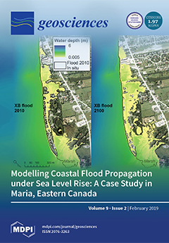
Coastal managers and communities often rely on design storm scenarios to define flood-prone areas. When tide gauge records are limited, knowledge on historical extreme events is crucial to validate flood models and assess the impact of sea level rise. In this study, the process-based XBeach model is used for hydrodynamic simulations of extreme floods in Maria (Eastern Canada). The model is first validated with field observations of waves and water levels. Based on field surveys of sediment deposited inland during a flood in December 2010, results underline the good performance of XBeach (60% fit) for coastal flood mapping. Using a local sea level trend from tide gauge analyses, this paper shows that sea level rise on the low-lying coastal community of Maria could induce a larger flood area in 2100, deeper floodwater, and higher flow velocities, resulting in a higher hazard for the population. View this [...] Read more.
  • Issues are regarded as officially published after their release is announced to the table of contents alert mailing list.
  • You may sign up for e-mail alerts to receive table of contents of newly released issues.
  • PDF is the official format for papers published in both, html and pdf forms. To view the papers in pdf format, click on the "PDF Full-text" link, and use the free Adobe Reader to open them.
Order results
Result details
Section
Select all
Export citation of selected articles as:
16 pages, 11275 KiB  
Article
Application of a Real-Time Tsunami Forecast System to the Disaster Response of Local Governments during a Major Tsunami Disaster
by Tomohiro Kubo, Wataru Suzuki, Masahiro Ooi, Narumi Takahashi, Kazumi Asao and Kaoru Yoshioka
Geosciences 2019, 9(2), 102; https://0-doi-org.brum.beds.ac.uk/10.3390/geosciences9020102 - 24 Feb 2019
Cited by 2 | Viewed by 3492
Abstract
We applied a real-time tsunami inundation forecast system to a disaster response plan. We developed a standard operating procedure (SOP) for a tsunami disaster response based on a Plan, Do, Check, Action cycle to effectively use tsunami observation and prediction information provided by [...] Read more.
We applied a real-time tsunami inundation forecast system to a disaster response plan. We developed a standard operating procedure (SOP) for a tsunami disaster response based on a Plan, Do, Check, Action cycle to effectively use tsunami observation and prediction information provided by a real-time tsunami inundation forecast system during an initial response to a tsunami disaster. In the Plan stage, we ran a workshop on the tsunami disaster response to confirm the current tsunami disaster response plan and develop a timeline plan for a tsunami disaster. In the Do stage, we conducted a tabletop exercise (TTX) for a tsunami disaster using a real-time tsunami prediction system. In the Check stage, we ran a workshop on an after-action review of the TTX. In the Action stage, we applied the SOPs of the real-time tsunami prediction system to the tsunami disaster management plan and conducted a second TTX. As a result, we verified the information provided by a real-time tsunami prediction system to apply the system to a tsunami disaster management plan for real municipalities. It was confirmed that the SOP that we developed allows a real-time tsunami inundation forecast system to enable government staff to safely and effectively respond during a disaster. Full article
(This article belongs to the Special Issue Marine Geohazards: New Insights and Perspectives)
Show Figures

Figure 1

15 pages, 1481 KiB  
Article
Kinetics of White Soft Minerals (WSMs) Decomposition under Conditions of Interest for Astrobiology: A Theoretical and Experimental Study
by Gaia Micca Longo, Marcella D’Elia, Sergio Fonti, Savino Longo, Francesca Mancarella and Vincenzo Orofino
Geosciences 2019, 9(2), 101; https://0-doi-org.brum.beds.ac.uk/10.3390/geosciences9020101 - 23 Feb 2019
Cited by 8 | Viewed by 2774
Abstract
In this paper, the thermal decomposition kinetics of a class of minerals that we call White Soft Minerals (WSMs) is studied by means of theoretical and experimental methods, in connection to the transport of extraterrestrial organic matter to Earth and the possible use [...] Read more.
In this paper, the thermal decomposition kinetics of a class of minerals that we call White Soft Minerals (WSMs) is studied by means of theoretical and experimental methods, in connection to the transport of extraterrestrial organic matter to Earth and the possible use of the decomposition reaction in the characterization of these minerals in space. WSMs include, under a single denomination, carbonates and sulphates of Mg, Fe, and Ca. To improve the present knowledge of the properties of such materials, we use the following techniques: kinetic models for chemical decomposition, atmospheric entry models, spectroscopy, and gravimetric analyses. Model results show that the atmospheric entry of WSM grains is strongly affected by their thermal decomposition. The decomposition reaction, being strongly endothermic, tends to significantly lower the grain temperature during the atmospheric entry, especially at high altitudes and for grazing entries. A previously proposed infrared spectroscopic technique to evaluate the degree of advancement of the reaction is found to be in good agreement with gravimetric measurements for calcium carbonate. The numerical model developed for the atmospheric entry scenarios is used to interpret experimental results. These main findings show that an additional contribution to the reaction enthalpy is needed to reproduce the experimental results, suggesting that the present theoretical model needs improvements such as the account of gas diffusion in the materials. Full article
(This article belongs to the Special Issue Planetary Evolution and Search for Life on Habitable Planets)
Show Figures

Figure 1

10 pages, 5118 KiB  
Article
The Use of Gigapixel Photogrammetry for the Understanding of Landslide Processes in Alpine Terrain
by Saverio Romeo, Lucio Di Matteo, Daniel Scott Kieffer, Grazia Tosi, Aurelio Stoppini and Fabio Radicioni
Geosciences 2019, 9(2), 99; https://0-doi-org.brum.beds.ac.uk/10.3390/geosciences9020099 - 21 Feb 2019
Cited by 14 | Viewed by 4077
Abstract
The work in this paper illustrates an experimental application for geosciences by coupling new and low cost photogrammetric techniques: Gigapixel and Structure-from-Motion (SfM). Gigapixel photography is a digital image composed of billions of pixels (≥1000 megapixels) obtained from a conventional Digital single-lens reflex [...] Read more.
The work in this paper illustrates an experimental application for geosciences by coupling new and low cost photogrammetric techniques: Gigapixel and Structure-from-Motion (SfM). Gigapixel photography is a digital image composed of billions of pixels (≥1000 megapixels) obtained from a conventional Digital single-lens reflex camera (DSLR), whereas the SfM technique obtains three-dimensional (3D) information from two-dimensional (2D) image sequences. The field test was carried out at the Ingelsberg slope (Bad Hofgastein, Austria), which hosts one of the most dangerous landslides in the Salzburg Land. The stereographic analysis carried out on the preliminary 3D model, integrated with Ground Based Synthetic Aperture Radar Interferometry (GBInSAR) data, allowed us to obtain the main fractures and discontinuities of the unstable rock mass. Full article
(This article belongs to the Special Issue Mountain Landslides: Monitoring, Modeling, and Mitigation)
Show Figures

Graphical abstract

37 pages, 8750 KiB  
Review
Marine Geohazards: A Bibliometric-Based Review
by João M. R. Camargo, Marcos V. B. Silva, Antônio V. Ferreira Júnior and Tereza C. M. Araújo
Geosciences 2019, 9(2), 100; https://0-doi-org.brum.beds.ac.uk/10.3390/geosciences9020100 - 21 Feb 2019
Cited by 30 | Viewed by 8590
Abstract
Marine geohazard research has developed during recent decades, as human activities intensified towards deeper waters. Some recent disastrous events (e.g., the 2004 Indian Ocean and 2011 Japan tsunamis) highlighted geohazards socioeconomic impacts. Marine geohazards encompass an extensive list of features, processes, and events [...] Read more.
Marine geohazard research has developed during recent decades, as human activities intensified towards deeper waters. Some recent disastrous events (e.g., the 2004 Indian Ocean and 2011 Japan tsunamis) highlighted geohazards socioeconomic impacts. Marine geohazards encompass an extensive list of features, processes, and events related to Marine Geology. In the scientific literature there are few systematic reviews concerning all of them. Using the search string ‘geohazard*’, this bibliometric-based review explored the scientific databases Web of Science and Scopus to analyze the evolution of peer-reviewed scientific publications and discuss trends and future challenges. The results revealed qualitative and quantitative aspects of 183 publications and indicated 12 categories of hazards, the categories more studied and the scientific advances. Interdisciplinary surveys focusing on the mapping and dating of past events, and the determination of triggers, frequencies, and current perspectives of occurrence (risk) are still scarce. Throughout the upcoming decade, the expansion and improvement of seafloor observatories’ networks, early warning systems, and mitigation plans are the main challenges. Hazardous marine geological events may occur at any time and the scientific community, marine industry, and governmental agencies must cooperate to better understand and monitor the processes involved in order to mitigate the resulting unpredictable damages. Full article
(This article belongs to the Special Issue Marine Geohazards: New Insights and Perspectives)
Show Figures

Figure 1

22 pages, 7257 KiB  
Article
Locating Cave Entrances Using Lidar-Derived Local Relief Modeling
by Holley Moyes and Shane Montgomery
Geosciences 2019, 9(2), 98; https://0-doi-org.brum.beds.ac.uk/10.3390/geosciences9020098 - 20 Feb 2019
Cited by 14 | Viewed by 12220
Abstract
Lidar (Light detection and ranging) scanning has revolutionized our ability to locate geographic features on the earth’s surface, but there have been few studies that have addressed discovering caves using this technology. Almost all attempts to find caves using lidar imagery have focused [...] Read more.
Lidar (Light detection and ranging) scanning has revolutionized our ability to locate geographic features on the earth’s surface, but there have been few studies that have addressed discovering caves using this technology. Almost all attempts to find caves using lidar imagery have focused on locating sinkholes that lead to underground cave systems. As archaeologists, our work in the Chiquibul Forest Reserve, a heavily forested area in western Belize, focuses on locating potential caves for investigation. Caves are an important part of Maya cultural heritage utilized by the ancient Maya people as ritual spaces. These sites contain large numbers of artifacts, architecture, and human remains, but are being looted at a rapid rate; therefore, our goal is to locate and investigate as many sites as possible during our field seasons. While some caves are entered via sinkholes, most are accessed via vertical cliff faces or are entered by dropping into small shafts. Using lidar-derived data, our goal was to locate and investigate not only sinkholes but other types of cave entrances using point cloud modeling. In this article, we describe our method for locating potential cave openings using local relief models that require only a working knowledge of relief visualization techniques. By using two pedestrian survey techniques, we confirmed a high rate of accuracy in locating cave entrances that varied in both size and morphology. Although 100% pedestrian survey coverage delivered the highest rate accuracy in cave detection, lidar image analyses proved to be expedient for meeting project goals when considering time and resource constraints. Full article
Show Figures

Figure 1

15 pages, 1902 KiB  
Article
Automated Classification of Terrestrial Images: The Contribution to the Remote Sensing of Snow Cover
by Roberto Salzano, Rosamaria Salvatori, Mauro Valt, Gregory Giuliani, Bruno Chatenoux and Luca Ioppi
Geosciences 2019, 9(2), 97; https://0-doi-org.brum.beds.ac.uk/10.3390/geosciences9020097 - 19 Feb 2019
Cited by 19 | Viewed by 5061
Abstract
The relation between the fraction of snow cover and the spectral behavior of the surface is a critical issue that must be approached in order to retrieve the snow cover extent from remotely sensed data. Ground-based cameras are an important source of datasets [...] Read more.
The relation between the fraction of snow cover and the spectral behavior of the surface is a critical issue that must be approached in order to retrieve the snow cover extent from remotely sensed data. Ground-based cameras are an important source of datasets for the preparation of long time series concerning the snow cover. This study investigates the support provided by terrestrial photography for the estimation of a site-specific threshold to discriminate the snow cover. The case study is located in the Italian Alps (Falcade, Italy). The images taken over a ten-year period were analyzed using an automated snow-not-snow detection algorithm based on Spectral Similarity. The performance of the Spectral Similarity approach was initially investigated comparing the results with different supervised methods on a training dataset, and subsequently through automated procedures on the entire dataset. Finally, the integration with satellite snow products explored the opportunity offered by terrestrial photography for calibrating and validating satellite-based data over a decade. Full article
(This article belongs to the Special Issue Remote Sensing of Snow and Its Applications)
Show Figures

Graphical abstract

20 pages, 5902 KiB  
Benchmark
Signal Processing of GPR Data for Road Surveys
by Luca Bianchini Ciampoli, Fabio Tosti, Nikos Economou and Francesco Benedetto
Geosciences 2019, 9(2), 96; https://0-doi-org.brum.beds.ac.uk/10.3390/geosciences9020096 - 19 Feb 2019
Cited by 85 | Viewed by 9891
Abstract
Effective quality assurance and quality control inspections of new roads as well as assessment of remaining service-life of existing assets is taking priority nowadays. Within this context, use of ground penetrating radar (GPR) is well-established in the field, although standards for a correct [...] Read more.
Effective quality assurance and quality control inspections of new roads as well as assessment of remaining service-life of existing assets is taking priority nowadays. Within this context, use of ground penetrating radar (GPR) is well-established in the field, although standards for a correct management of datasets collected on roads are still missing. This paper reports a signal processing method for data acquired on flexible pavements using GPR. To demonstrate the viability of the method, a dataset collected on a real-life flexible pavement was used for processing purposes. An overview of the use of non-destructive testing (NDT) methods in the field, including GPR, is first given. A multi-stage method is then presented including: (i) raw signal correction; (ii) removal of lower frequency harmonics; (iii) removal of antenna ringing; (iv) signal gain; and (v) band-pass filtering. Use of special processing steps such as vertical resolution enhancement, migration and time-to-depth conversion are finally discussed. Key considerations about the effects of each step are given by way of comparison between processed and unprocessed radargrams. Results have proven the viability of the proposed method and provided recommendations on use of specific processing stages depending on survey requirements and quality of the raw dataset. Full article
(This article belongs to the Special Issue Advances in Ground Penetrating Radar Research)
Show Figures

Figure 1

15 pages, 4871 KiB  
Article
Nitrogen Cycle Dynamics Revealed Through δ18O-NO3 Analysis in California Groundwater
by Nate Veale, Ate Visser, Bradley Esser, Michael J. Singleton and Jean E. Moran
Geosciences 2019, 9(2), 95; https://0-doi-org.brum.beds.ac.uk/10.3390/geosciences9020095 - 18 Feb 2019
Cited by 8 | Viewed by 4073
Abstract
Nitrate is a significant water-quality issue in California, the United States as a whole, and the world. Critical to addressing nitrate contamination is understanding the presence and extent of denitrification, and further refining the techniques used to identify nitrate sources. The use and [...] Read more.
Nitrate is a significant water-quality issue in California, the United States as a whole, and the world. Critical to addressing nitrate contamination is understanding the presence and extent of denitrification, and further refining the techniques used to identify nitrate sources. The use and understanding of nitrate isotopic signatures to identify nitrate sources have advanced tremendously; however, knowledge gaps remain concerning specific fractionation pathways and the role of denitrification in altering source values. Using a large unique database of California groundwater nitrate isotopic compositions, we explored the utility of nitrate–oxygen isotope ratios in determining specific nitrate origins. Lawrence Livermore National Lab (LLNL) samples were supplemented by United States Geological Society (USGS) data to create a dataset of over 1200 dual-isotope results. Methods used at LLNL allowed for the determination of δ15N-NO3, δ18O-NO3, δ18O-H2O, δ2H-H2O, excess air, major dissolved gases, and excess N2. Results were examined for the degree to which δ18O-NO3 conforms to the model of nitrification in which two atoms of oxygen are sourced from ambient water and one from the atmosphere. Almost 80% of the results fall within one standard deviation of predicted values. However, 19% of samples had significantly higher values, suggesting the preservation of a synthetic nitrate source signature, mixing of sources, or widespread denitrification. Results were examined with respect to general land-use classifications and, while nitrate concentrations followed the expected pattern of being higher in agricultural settings, δ18O-NO3patterns are complicated by application of N-fertilizer in various forms, and subsequent N cycling in the soil zone. We found that the current understanding of oxygen isotope-fractionation mechanisms cannot yet explain the prevalence of oxygen-isotope compositions with higher than predicted δ18O values, but when paired with related data such as land use and indicators of denitrification, oxygen-isotope compositions of nitrate can help to assess nitrogen cycle dynamics. Full article
(This article belongs to the Special Issue Hydrogeochemistry and Groundwater Management)
Show Figures

Figure 1

12 pages, 3913 KiB  
Article
Glaciochemistry of Cave Ice: Paradana and Snežna Caves, Slovenia
by Anne E. Carey, Matija Zorn, Jure Tičar, Matej Lipar, Blaž Komac, Susan A. Welch, Devin F. Smith and William Berry Lyons
Geosciences 2019, 9(2), 94; https://0-doi-org.brum.beds.ac.uk/10.3390/geosciences9020094 - 18 Feb 2019
Cited by 7 | Viewed by 4500
Abstract
Cave ice samples collected within karstic terrain have major ion and nutrient concentrations showing that the ice originates from local precipitation modified by the addition of Ca2+ and HCO3 from the dissolution of the local bedrock. Isotopic profiles of Paradana [...] Read more.
Cave ice samples collected within karstic terrain have major ion and nutrient concentrations showing that the ice originates from local precipitation modified by the addition of Ca2+ and HCO3 from the dissolution of the local bedrock. Isotopic profiles of Paradana Cave ice are similar to those described in other ice caves in central and eastern Europe, where the profiles are developed through the freezing of cave pool or “lake” waters from the top downward during the onset of the cold portion of the year. Stable isotope data suggest future studies may yield a long-term paleo-environmental record for this location. Full article
(This article belongs to the Special Issue Isotope Geochemistry of Meteoric Waters)
Show Figures

Figure 1

44 pages, 3862 KiB  
Review
Gadolinium as an Emerging Microcontaminant in Water Resources: Threats and Opportunities
by Pooria Ebrahimi and Maurizio Barbieri
Geosciences 2019, 9(2), 93; https://0-doi-org.brum.beds.ac.uk/10.3390/geosciences9020093 - 17 Feb 2019
Cited by 72 | Viewed by 11629
Abstract
As a result of high doses of paramagnetic gadolinium (Gd) chelates administered in magnetic resonance imaging (MRI) exams, their unmetabolized excretion, and insufficient removal in wastewater treatment plants (WWTPs), large amounts of anthropogenic Gd (Gdanth) are released into surface water. The [...] Read more.
As a result of high doses of paramagnetic gadolinium (Gd) chelates administered in magnetic resonance imaging (MRI) exams, their unmetabolized excretion, and insufficient removal in wastewater treatment plants (WWTPs), large amounts of anthropogenic Gd (Gdanth) are released into surface water. The upward trend of gadolinium-based contrast agent (Gd-CA) administrations is expected to continue growing and consequently higher and higher anthropogenic Gd concentrations are annually recorded in water resources, which can pose a great threat to aquatic organisms and human beings. In addition, the feasibility of Gd retention in patients administered with Gd-CAs repeatedly, and even potentially fatal diseases, including nephrogenic systemic fibrosis (NSF), due to trace amounts of Gd have recently arisen severe health concerns. Thus, there is a need to investigate probable adverse health effects of currently marketed Gd-CAs meticulously and to modify the actual approach in using Gd contrast media in daily practice in order to minimize unknown possible health risks. Furthermore, the employment of enhanced wastewater treatment processes that are capable of removing the stable contrast agents, and the evaluation of the ecotoxicity of Gd chelates and human exposure to these emerging contaminants through dermal and ingestion pathways deserve more attention. On the other hand, point source releases of anthropogenic Gd into the aquatic environment presents the opportunity to assess surface water—groundwater interactions and trace the fate of wastewater plume as a proxy for the potential presence of other microcontaminants associated with treated wastewater in freshwater and marine systems. Full article
(This article belongs to the Special Issue Emerging contaminants (ECs) in Groundwater)
Show Figures

Figure 1

11 pages, 1310 KiB  
Hypothesis
The Rise of A Habitable Planet: Four Required Conditions for the Origin of Life in the Universe
by Vladimir Kompanichenko
Geosciences 2019, 9(2), 92; https://0-doi-org.brum.beds.ac.uk/10.3390/geosciences9020092 - 16 Feb 2019
Cited by 14 | Viewed by 5559
Abstract
The advanced version of the author’s inversion concept of the origin of terrestrial life and its application for life in the Universe has been substantiated. A key step in the transition to life consists in the thermodynamic inversion of non-living prebiotic microsystems when [...] Read more.
The advanced version of the author’s inversion concept of the origin of terrestrial life and its application for life in the Universe has been substantiated. A key step in the transition to life consists in the thermodynamic inversion of non-living prebiotic microsystems when the contributions of free energy (F) and information (I) become prevalent over the contribution of entropy (S). It is based the thermodynamic corridor that is mandatory for all chemical scenarios for the origin of life: F + I < S (prebiotic microsystem) → F + I ≈ S (intermediate stage, inversion moment) → F + I > S (primary living unit). A prebiotic organic microsystem can reach the intermediate state between non-life and life only under high-frequency and multilevel oscillations of physic-chemical parameters in hydrothermal environments. The oscillations are considered the fourth required condition for the origin of life, in addition to the three well-known ones: the availability of organic matter, an aqueous medium, and a source of energy. The emergence of initial life sparks in nonequilibrium prebiotic microsystems (being at the intermediate state) proceeds through the continuous response (counteraction) of prebiotic microsystems to incessant physic-chemical oscillations (stress). The next step of laboratory simulations on the origin of life directed to the exploration of the microsystems’ response to high-frequency oscillations (>10−10 s–<30 min) is proposed. Finally, some fragments of the general scenario of the origin of life in the Universe based on the whole four required conditions have been outlined. Full article
(This article belongs to the Special Issue Planetary Evolution and Search for Life on Habitable Planets)
Show Figures

Figure 1

22 pages, 3755 KiB  
Article
Fifteen Years of Radionuclide Research at the KIT Synchrotron Source in the Context of the Nuclear Waste Disposal Safety Case
by Jörg Rothe, Marcus Altmaier, Ron Dagan, Kathy Dardenne, David Fellhauer, Xavier Gaona, Ernesto González-Robles Corrales, Michel Herm, Kristina O. Kvashnina, Volker Metz, Ivan Pidchenko, Dieter Schild, Tonya Vitova and Horst Geckeis
Geosciences 2019, 9(2), 91; https://0-doi-org.brum.beds.ac.uk/10.3390/geosciences9020091 - 15 Feb 2019
Cited by 19 | Viewed by 5196
Abstract
For more than 120 years, systematic studies of X-ray interaction with matter have been the basis for our understanding of materials—both of natural or man-made origin—and their structure-function relationships. Beginning with simple radiographic imaging at the end of the 19th century, X-ray based [...] Read more.
For more than 120 years, systematic studies of X-ray interaction with matter have been the basis for our understanding of materials—both of natural or man-made origin—and their structure-function relationships. Beginning with simple radiographic imaging at the end of the 19th century, X-ray based analytical tools such as X-ray diffraction, X-ray fluorescence and photoemission or X-ray absorption techniques are indispensable in almost any field of chemical and material sciences—including basic and applied actinide and radionuclide studies. The advent of dedicated synchrotron radiation (SR) sources in the second half of the last century has revolutionized the analytical power of X-ray probes, while—with increasing number of SR facilities—beamline instrumentation followed a trend towards increasing specialization and adaption to a major research topic. The INE-Beamline and ACT station at the KIT synchrotron source belong to the exclusive club of a few synchrotron beamline facilities—mostly located in Europe—dedicated to the investigation of highly radioactive materials. Since commissioning of the INE-Beamline in 2005, capabilities for synchrotron-based radionuclide and actinide sciences at KIT have been continuously expanded, driven by in-house research programs and external user needs. Full article
Show Figures

Figure 1

3 pages, 160 KiB  
Commentary
Commentary on Sequestering Atmospheric CO2 Inorganically: A Solution for Malaysia’s CO2 Emission
by John Barry Gallagher, Nithiyaa Nilamani and Norlaila Binti Mohd Zanuri
Geosciences 2019, 9(2), 90; https://0-doi-org.brum.beds.ac.uk/10.3390/geosciences9020090 - 15 Feb 2019
Viewed by 2325
Abstract
The commentary questions the basis behind an article on accounting and calculating inorganic carbon sequestration services for Malaysia. We point out the omission of coastal vegetated ecosystems. We also bring the author’s attention to the problems of using a seemingly resultant chemistry within [...] Read more.
The commentary questions the basis behind an article on accounting and calculating inorganic carbon sequestration services for Malaysia. We point out the omission of coastal vegetated ecosystems. We also bring the author’s attention to the problems of using a seemingly resultant chemistry within open systems, in which reactive species come from external sources. In addition, we point out that ecosystem services in the mitigation of climate change must be referenced against a manufacturing process, such as cement’s normal lifetime of carbon dioxide sequestration. Without such a reference state, sequestration services may be severely overestimated and when used within a cap and trade system, it will lead to an increased rate of carbon dioxide emissions. Full article
(This article belongs to the Special Issue Carbon Sequestration)
23 pages, 2024 KiB  
Article
Modelling of a Large Landslide Problem under Water Level Fluctuation—Model Calibration and Verification
by Xiang Li, Chenyang Zhao, Raoul Hölter, Maria Datcheva and Arash Alimardani Lavasan
Geosciences 2019, 9(2), 89; https://0-doi-org.brum.beds.ac.uk/10.3390/geosciences9020089 - 14 Feb 2019
Cited by 7 | Viewed by 3415
Abstract
In past centuries, reservoir landslides have been always a threat that brought a big loss in lives and properties. The phenomena that have decisive influence on the landslide instability are quite complex and the importance of each of them for the stability of [...] Read more.
In past centuries, reservoir landslides have been always a threat that brought a big loss in lives and properties. The phenomena that have decisive influence on the landslide instability are quite complex and the importance of each of them for the stability of a particular landslide differs. Therefore, it is extremely important to distinguish between the effects that different phenomena have and to identify those that dominate the behaviour of the studied landslide. The aim of the present study is to investigate the behaviour under the river level fluctuation of a large landslide in China, namely the Huangtupo landslide. A 2D numerical model of a selected part of the Huangtupo landslide is created and a series of fully coupled hydro-mechanical simulations have been conducted to investigate the landslide behaviour under different influencing factors (e.g., mechanical incidents, water head, soil water permeability, etc.). Furthermore, both local and global sensitivity analyses are performed to assess the importance of these influencing factors and to select the most influential model parameters. Thereafter, back analysis is employed to calibrate the model against real field data. Finally, the capability of the calibrated model is evaluated and the results show that it can simulate appropriately the long-term behaviour of the landslide after the river level reaches its maximal level. Full article
(This article belongs to the Special Issue Mountain Landslides: Monitoring, Modeling, and Mitigation)
Show Figures

Figure 1

16 pages, 3790 KiB  
Article
Fluid Inclusions at the Plavica Au-Ag-Cu Telescoped Porphyry–Epithermal System, Former Yugoslavian Republic of Macedonia (FYROM)
by Vasilios Melfos, Panagiotis Voudouris, Todor Serafimovski and Goran Tasev
Geosciences 2019, 9(2), 88; https://0-doi-org.brum.beds.ac.uk/10.3390/geosciences9020088 - 14 Feb 2019
Cited by 6 | Viewed by 3543
Abstract
The Plavica Au-Ag-Cu porphyry and high sulfidation (HS) epithermal deposit is located at the Kratovo–Zlatovo volcanic field in Eastern Former Yugoslavian Republic of Macedonia. In this study, new fluid inclusions data provide additional evidence of the presence of a porphyry style mineralization which [...] Read more.
The Plavica Au-Ag-Cu porphyry and high sulfidation (HS) epithermal deposit is located at the Kratovo–Zlatovo volcanic field in Eastern Former Yugoslavian Republic of Macedonia. In this study, new fluid inclusions data provide additional evidence of the presence of a porphyry style mineralization which is associated with an overlain HS epithermal deposit. The Oligocene–Miocene magmatic rocks have a calc–alkaline to high-K calc–alkaline affinity and consist of sub-volcanic intrusions and volcanic rocks. Previous studies distinguished four alteration types: (a) Sericitic, (b) advanced argillic, (c) silicification, and (d) propylitic alteration. Fluid inclusions showed an early magmatic brine in porphyry style veins with high salinity (33–57 wt% NaCl equiv.), which coexists with a vapor rich fluid with lower salinity (14–20 wt% NaCl equiv.), at temperatures 380–500 °C, under boiling conditions. At shallower depths, the fluid inclusions demonstrate various HS–epithermal deposits which were formed by moderate to low salinity (3–14 wt% NaCl equiv.) hydrothermal fluids at lower temperatures from 200 to 300 °C. Full article
(This article belongs to the Special Issue Magmatic-Hydrothermal Ore Deposits)
Show Figures

Graphical abstract

20 pages, 6217 KiB  
Article
Rhyolite Domes and Subsequent Offlap of Pliocene Carbonates on Volcanic Islets at San Basilio (Baja California Sur, Mexico)
by Markes E. Johnson, David H. Backus, Ana Luisa Carreño and Jorge Ledesma-Vázquez
Geosciences 2019, 9(2), 87; https://0-doi-org.brum.beds.ac.uk/10.3390/geosciences9020087 - 14 Feb 2019
Cited by 2 | Viewed by 4000
Abstract
San Basilio basin in Baja California Sur (Mexico) exhibits distinct styles of volcanism that interrupted phases of normal sedimentation correlated with the Zanclean Stage (Lower Pliocene). Sea cliffs around a 4-km2 bay opening onto the Gulf of California are dominated by rhyolite, [...] Read more.
San Basilio basin in Baja California Sur (Mexico) exhibits distinct styles of volcanism that interrupted phases of normal sedimentation correlated with the Zanclean Stage (Lower Pliocene). Sea cliffs around a 4-km2 bay opening onto the Gulf of California are dominated by rhyolite, mudstone, sandstone, and limestone. Volcanism associated with re-sedimented hyaloclastite is regionally uncommon and the goal was to investigate interactions between volcanic events and intervals of stability represented by fossil-rich strata. Methods of study involved a combination of microfossil and macrofossil analyses. Relating the basin’s faults to Pliocene development in the greater Gulf of California was a secondary goal. Microfossils Bolivina bicostata and B. interjuncta recovered from mudstone indicate an initial water column of 150 m. An abrupt hydromagmatic explosion ruptured the mudstone cover, followed by banded rhyolite flows inter-bedded with sandstone. Outlying limestone beds with the index fossil Clypeaster bowersi are separated from rhyolite by conglomerate eroded under intertidal conditions. A renewed phase of activity saw eruption of smaller volcanoes in the basin center semi-contemporaneous with pecten limestone deposited on unstable slopes. Normal faults conform to a pattern of extensional rifting in the proto-gulf, followed by cross-cutting faults indicating the onset of transtensional tectonics beginning about 3.5 Ma. Full article
(This article belongs to the Section Biogeosciences)
Show Figures

Figure 1

15 pages, 24737 KiB  
Article
Cross-Correlation and Cross-Spectral Analysis of the Hydrographs in the Northern Part of the Dinaric Karst of Croatia
by Krešimir Pavlić and Jelena Parlov
Geosciences 2019, 9(2), 86; https://0-doi-org.brum.beds.ac.uk/10.3390/geosciences9020086 - 13 Feb 2019
Cited by 12 | Viewed by 4711
Abstract
Correlation and cross-spectral analysis of hydrographs was performed on the karst area of the mountainous section of the Kupa River in two time periods. Since there are karst aquifers in this area that is a part of strategic groundwater reserves of potable water, [...] Read more.
Correlation and cross-spectral analysis of hydrographs was performed on the karst area of the mountainous section of the Kupa River in two time periods. Since there are karst aquifers in this area that is a part of strategic groundwater reserves of potable water, such an analysis could give better insight into the behavior of these aquifers. The functions used to describe karst aquifers are the cross-correlation function, coherence function, gain function, and phase function. The outcomes of the analysis results were very similar in the two analyzed periods, suggesting that differences in input signals between these two periods do not affect the aquifer function as a system filter. The results of this research suggest that the aquifer and overburden layer characteristics have a much stronger influence than the change of input signal on the runoff regime in the considered period. Full article
Show Figures

Figure 1

8 pages, 1069 KiB  
Article
Using Size and Composition to Assess the Quality of Lunar Impact Glass Ages
by Pham Nguyen and Nicolle Zellner
Geosciences 2019, 9(2), 85; https://0-doi-org.brum.beds.ac.uk/10.3390/geosciences9020085 - 13 Feb 2019
Cited by 4 | Viewed by 3091
Abstract
Determining the impact chronology of the Moon is an important yet challenging problem in planetary science even after decades of lunar samples and other analyses. In addition to crater counting statistics, orbital data, and dynamical models, well-constrained lunar sample ages are critical for [...] Read more.
Determining the impact chronology of the Moon is an important yet challenging problem in planetary science even after decades of lunar samples and other analyses. In addition to crater counting statistics, orbital data, and dynamical models, well-constrained lunar sample ages are critical for proper interpretation of the Moon’s impact chronology. To understand which properties of lunar impact glasses yield well-constrained ages, we evaluated the compositions and sizes of 119 Apollo 14, 15, 16, and 17 impact glass samples whose compositions and 40Ar/39Ar ages have already been published, and we present new data on 43 others. These additional data support previous findings that the composition and size of the glass are good indicators of the quality of the age plateau derived for each sample. We have further constrained those findings: Glasses of ≥200 μm with a fraction of non-bridging oxygens (X(NBO)) of ≥0.23 and a K2O (wt%) of ≥0.07 are prime candidates for argon analyses and more likely to yield well-constrained 40Ar/39Ar ages. As a result, science resulting from impact glass analyses is maximized while analytical costs per glass are minimized. This has direct implications for future analyses of glass samples for both those in the current lunar collection and those that have yet to be collected. Full article
(This article belongs to the Special Issue Recent Advances in Lunar Studies)
Show Figures

Figure 1

18 pages, 4998 KiB  
Article
Picking Up the Pieces—Harmonising and Collating Seabed Substrate Data for European Maritime Areas
by Anu Marii Kaskela, Aarno Tapio Kotilainen, Ulla Alanen, Rhys Cooper, Sophie Green, Janine Guinan, Sytze van Heteren, Susanna Kihlman, Vera Van Lancker, Alan Stevenson and the EMODnet Geology Partners
Geosciences 2019, 9(2), 84; https://0-doi-org.brum.beds.ac.uk/10.3390/geosciences9020084 - 13 Feb 2019
Cited by 28 | Viewed by 6274
Abstract
The poor access to data on the marine environment is a handicap to government decision-making, a barrier to scientific understanding and an obstacle to economic growth. In this light, the European Commission initiated the European Marine Observation and Data Network (EMODnet) in 2009 [...] Read more.
The poor access to data on the marine environment is a handicap to government decision-making, a barrier to scientific understanding and an obstacle to economic growth. In this light, the European Commission initiated the European Marine Observation and Data Network (EMODnet) in 2009 to assemble and disseminate hitherto dispersed marine data. In the ten years since then, EMODnet has become a key producer of publicly available, harmonised datasets covering broad areas. This paper describes the methodologies applied in EMODnet Geology project to produce fully populated GIS layers of seabed substrate distribution for the European marine areas. We describe steps involved in translating national seabed substrate data, conforming to various standards, into a uniform EMODnet substrate classification scheme (i.e., the Folk sediment classification). Rock and boulders form an additional substrate class. Seabed substrate data products at scales of 1:250,000 and 1:1 million, compiled using descriptions and analyses of seabed samples as well as interpreted acoustic images, cover about 20% and 65% of the European maritime areas, respectively. A simple confidence assessment, based on sample and acoustic coverage, is helpful in identifying data gaps. The harmonised seabed substrate maps are particularly useful in supraregional, transnational and pan-European marine spatial planning. Full article
(This article belongs to the Special Issue Geological Seafloor Mapping)
Show Figures

Figure 1

13 pages, 2391 KiB  
Article
Intraspecific Length Variation and Shell Thickness of the Ostracod Cyprideis torosa (Jones, 1850) as a Potential Tool for Palaeosalinity Characterization
by Christopher Berndt, Peter Frenzel and Attila Çiner
Geosciences 2019, 9(2), 83; https://0-doi-org.brum.beds.ac.uk/10.3390/geosciences9020083 - 13 Feb 2019
Cited by 8 | Viewed by 4289
Abstract
Cyprideis torosa (Jones) is a common ostracod species in brackish waters of large parts of the world. The species appears in, but it is not restricted to, marginal marine areas, and it thus plays a significant role in identifying variable impacts between the [...] Read more.
Cyprideis torosa (Jones) is a common ostracod species in brackish waters of large parts of the world. The species appears in, but it is not restricted to, marginal marine areas, and it thus plays a significant role in identifying variable impacts between the marine and terrestrial realms as its carapace changes phenotypically under various conditions. This variability could be a highly valuable source of information in palaeoecology. We use valves of this species living in different lagoonal and lacustrine environments of the Kızılırmak Delta at the Turkish Black Sea coast since the Mid-Holocene. By measuring the valve sizes of adult individuals and A-1 instars and documenting the thickness classes of the adult shells we found a good positive correlation between the size of female valves and the prevailing salinity (correlation coefficient: 0.56), while such a correlation is lacking for ontogenetic stage A-1. No changes of the height/length ratio of the valves were recognizable along the salinity gradient. Shells are significantly thicker under relatively stable, higher saline conditions, but thinner in highly variable and low saline deltaic lakes. Both morphological features, size and shell thickness of C. torosa (Cyprideis torosa), are thus potential tools to give palaeo-environmental information, especially in C. torosa-dominated, low diversity marginal marine environments. Full article
Show Figures

Figure 1

18 pages, 6491 KiB  
Article
First Findings of Buried Late-Glacial Paleosols within the Dune Fields of the Tomsk Priobye Region (SE Western Siberia, Russia)
by Alexandr Konstantinov, Sergey Loiko, Alina Kurasova, Elizaveta Konstantinova, Andrey Novoselov, Georgy Istigechev and Sergey Kulizhskiy
Geosciences 2019, 9(2), 82; https://0-doi-org.brum.beds.ac.uk/10.3390/geosciences9020082 - 12 Feb 2019
Cited by 16 | Viewed by 3587
Abstract
Buried soils within aeolian deposits are considered an important tool for diagnosing, determining the age, and estimating the intensity of aeolian processes at the transition from the Pleistocene to the Holocene in the Northern Hemisphere. Late Pleistocene aeolian coversands and ancient inland dunes [...] Read more.
Buried soils within aeolian deposits are considered an important tool for diagnosing, determining the age, and estimating the intensity of aeolian processes at the transition from the Pleistocene to the Holocene in the Northern Hemisphere. Late Pleistocene aeolian coversands and ancient inland dunes are widely distributed in the periglacial zone of Western Siberia. In contrast to the territories of Central and Eastern Europe, the paleosol archive of the aeolian sands and dunes of Western Siberia has not yet been studied. This paper presents the first findings of late Pleistocene paleosols within the ancient inland dunes in the southeast of Western Siberia (Ob–Tomsk interfluve, Tomsk region). The soils and their stratigraphic position were studied in the outcrop of the quarry, located in the junction zone of the second Tom river terraces and the ancient valley. Two types of paleosols were identified. The first one is confined to the central part of a small dune and is represented by a slightly developed Albic Arenosol with fragmentary humus horizon Ahb and a well-pronounced Eb. It can probably be considered as an analogue of the European Usselo soil. The second paleosol was found at the bottom of the interdune depression. It is represented by a brown Bwb horizon and probably corresponds to a Brunic Arenosol (Dystric). The second paleosol is characterized by a higher content of clay fraction and organic carbon, the presence of weak signs of illuviation, and richer and more diverse mineral composition. This soil is apparently an analogue of the European Finow soil. Radiocarbon dating of the charcoals found in the paleosols suggests that the first dates from the Younger Dryas (ca. 12,036 cal. yr. BP), and the second one from the Allerød (ca. 13,355 cal. yr. BP). The study results propose that the natural environment in the periglacial zone of the south of Western Siberia was generally similar to those in Central and Eastern Europe, and the activation of aeolian processes, which led to the formation of a dune relief, occurred at about the same time. Full article
(This article belongs to the Special Issue The Imprint of Palaeoenvironments on Soils and Palaeosols)
Show Figures

Figure 1

15 pages, 1658 KiB  
Article
Neptunium(V) and Uranium(VI) Reactions at the Magnetite (111) Surface
by Pieter Bots, Arjen van Veelen, J. Frederick W. Mosselmans, Christopher Muryn, Roy A. Wogelius and Katherine Morris
Geosciences 2019, 9(2), 81; https://0-doi-org.brum.beds.ac.uk/10.3390/geosciences9020081 - 08 Feb 2019
Cited by 3 | Viewed by 3706
Abstract
Neptunium and uranium are important radionuclides in many aspects of the nuclear fuel cycle and are often present in radioactive wastes which require long term management. Understanding the environmental behaviour and mobility of these actinides is essential in underpinning remediation strategies and safety [...] Read more.
Neptunium and uranium are important radionuclides in many aspects of the nuclear fuel cycle and are often present in radioactive wastes which require long term management. Understanding the environmental behaviour and mobility of these actinides is essential in underpinning remediation strategies and safety assessments for wastes containing these radionuclides. By combining state-of-the-art X-ray techniques (synchrotron-based Grazing Incidence XAS, and XPS) with wet chemistry techniques (ICP-MS, liquid scintillation counting and UV-Vis spectroscopy), we determined that contrary to uranium(VI), neptunium(V) interaction with magnetite is not significantly affected by the presence of bicarbonate. Uranium interactions with a magnetite surface resulted in XAS and XPS signals dominated by surface complexes of U(VI), while neptunium on the surface of magnetite was dominated by Np(IV) species. UV-Vis spectroscopy on the aqueous Np(V) species before and after interaction with magnetite showed different speciation due to the presence of carbonate. Interestingly, in the presence of bicarbonate after equilibration with magnetite, an unknown aqueous NpO2+ species was detected using UV-Vis spectroscopy, which we postulate is a ternary complex of Np(V) with carbonate and (likely) an iron species. Regardless, the Np speciation in the aqueous phase (Np(V)) and on the magnetite (111) surfaces (Np(IV)) indicate that with and without bicarbonate the interaction of Np(V) with magnetite proceeds via a surface mediated reduction mechanism. Overall, the results presented highlight the differences between uranium and neptunium interaction with magnetite, and reaffirm the potential importance of bicarbonate present in the aqueous phase. Full article
Show Figures

Figure 1

18 pages, 10498 KiB  
Article
Stratigraphy, Petrography and Grain-Size Distribution of Sedimentary Lithologies at Cahuachi (South Peru): ENSO-Related Deposits or a Common Regional Succession?
by Marco Delle Rose, Michele Mattioli, Nicola Capuano and Alberto Renzulli
Geosciences 2019, 9(2), 80; https://0-doi-org.brum.beds.ac.uk/10.3390/geosciences9020080 - 08 Feb 2019
Cited by 3 | Viewed by 3674
Abstract
Several central Andean pre-Columbian sites struck by hydrogeological disasters due to El Niño-Southern Oscillation (ENSO) events are reported in the literature. The mainstream explanation for the decline and demise of Cahuachi (pampa of Nazca, south Peru) implies the damage and burial of [...] Read more.
Several central Andean pre-Columbian sites struck by hydrogeological disasters due to El Niño-Southern Oscillation (ENSO) events are reported in the literature. The mainstream explanation for the decline and demise of Cahuachi (pampa of Nazca, south Peru) implies the damage and burial of such a ceremonial center as a consequence of two catastrophic river floods, which occurred around 600 CE and 1000 CE, respectively. Therefore, geological studies at Cahuachi are mandatory with regard to both the correlations of ENSO-related deposits (“event-strata”) among different Peruvian sites and the assessment of the millennium-scale climate variability. In particular, the latter is crucial to evaluate the environmental and economic consequences due to the incoming fluctuations of ENSO. In this paper, stratigraphic, grain-size distribution, and petrographic investigations on a sedimentary section exposed close to one of the main temples of Cahuachi are reported. They represent the first test for the current mainstream explanation. The preliminary finding indicates that the studied stratigraphic interval may belong to the common regional succession of the pampa of Nazca rather than the ENSO-related deposits described in the literature. However, further geological research will be necessary to unravel this issue in more detail. Full article
Show Figures

Figure 1

12 pages, 3921 KiB  
Article
Nanoindentation Studies of Plasticity and Dislocation Creep in Halite
by Christopher A. Thom and David L. Goldsby
Geosciences 2019, 9(2), 79; https://0-doi-org.brum.beds.ac.uk/10.3390/geosciences9020079 - 06 Feb 2019
Cited by 14 | Viewed by 3523
Abstract
Previous deformation experiments on halite have collectively explored different creep mechanisms, including dislocation creep and pressure solution. Here, we use an alternative to conventional uniaxial or triaxial deformation experiments—nanoindentation tests—to measure the hardness and creep behavior of single crystals of halite at room [...] Read more.
Previous deformation experiments on halite have collectively explored different creep mechanisms, including dislocation creep and pressure solution. Here, we use an alternative to conventional uniaxial or triaxial deformation experiments—nanoindentation tests—to measure the hardness and creep behavior of single crystals of halite at room temperature. The hardness tests reveal two key phenomena: (1) strain rate-dependent hardness characterized by a value of the stress exponent of ~25, and (2) an indentation size effect, whereby hardness decreases with increasing size of the indents. Indentation creep tests were performed for hold times ranging from 3600 to 106 s, with a constant load of 100 mN. For hold times longer than 3 × 10⁴ s, a transition from plasticity to power-law creep is observed as the stress decreases during the hold, with the latter characterized by a value of the stress exponent of 4.87 ± 0.91. An existing theoretical analysis allows us to directly compare our indentation creep data with dislocation creep flow laws for halite derived from triaxial experiments on polycrystalline samples. Using this analysis, we show an excellent agreement between our data and the flow laws, with the strain rate at a given stress varying by less than 5% for a commonly used flow law. Our results underscore the utility of using nanoindentation as an alternative to more conventional methods to measure the creep behavior of geological materials. Full article
(This article belongs to the Special Issue Micromechanics of Reservoir and Cap Rocks)
Show Figures

Figure 1

15 pages, 4431 KiB  
Article
Composition Changes of Hydrocarbons during Secondary Petroleum Migration (Case Study in Cooper Basin, Australia)
by Sara Borazjani, David Kulikowski, Khalid Amrouch and Pavel Bedrikovetsky
Geosciences 2019, 9(2), 78; https://0-doi-org.brum.beds.ac.uk/10.3390/geosciences9020078 - 03 Feb 2019
Cited by 3 | Viewed by 8673
Abstract
The reliable mathematical modelling of secondary petroleum migration that incorporates structural geology and mature source rocks in the basin model, allows for prediction of the reservoir location, yielding the significant enhancement of the probability of exploration success. We investigate secondary petroleum migration with [...] Read more.
The reliable mathematical modelling of secondary petroleum migration that incorporates structural geology and mature source rocks in the basin model, allows for prediction of the reservoir location, yielding the significant enhancement of the probability of exploration success. We investigate secondary petroleum migration with a significant composition difference between the source and oil pools. In our case study, the secondary migration period is significantly shorter than the time of the hydrocarbon pulse generation. Therefore, neither adsorption nor dispersion of components can explain the concentration difference between the source rock and the reservoir. For the first time, the present paper proposes deep bed filtration of hydrocarbons with component kinetics retention by the rock as a physics mechanism explaining compositional grading. Introduction of the component capture rate into mass balance transport equation facilitates matching the concentration difference for heavy hydrocarbons, and the tuned filtration coefficients vary in their common range. The obtained values of filtration coefficients monotonically increase with molecular weight and consequently affects the size of the oleic component, as predicted by the analytical model of deep bed filtration. The modelling shows a negligible effect of component dispersion on the compositional grading. Full article
(This article belongs to the Special Issue Stress Quantification in Sedimentary Basins)
Show Figures

Figure 1

18 pages, 6259 KiB  
Article
GIS Framework for Spatiotemporal Mapping of Urban Flooding
by Sayed Joinal Hossain Abedin and Haroon Stephen
Geosciences 2019, 9(2), 77; https://0-doi-org.brum.beds.ac.uk/10.3390/geosciences9020077 - 02 Feb 2019
Cited by 16 | Viewed by 7409
Abstract
This research aims to develop a framework using the Geographic Information System (GIS) to perform modeling and mapping of flood spatiotemporal variation in urban micro-watersheds. The GIS-framework includes a workflow of several methods and processes including delineation of urban watershed, generation of runoff [...] Read more.
This research aims to develop a framework using the Geographic Information System (GIS) to perform modeling and mapping of flood spatiotemporal variation in urban micro-watersheds. The GIS-framework includes a workflow of several methods and processes including delineation of urban watershed, generation of runoff hydrographs, and time series mapping of inundation depths and flood extent. This framework is tested in areas previously known to have experienced flooding at the University of Nevada, Las Vegas main campus, including Black Parking Lot (Blacklot) and East Mall. Calibration is performed by varying Digital Elevation Model (DEM) resolution, rainfall temporal resolution, and clogging factor whereas validation is performed using flood information from news reports and photographs. The testing at the Blacklot site resulted in calibration at 5 m DEM resolution and clogging factor of 0.83. The flood model resulted in an error of 24% between the estimated (26 inches/66 cm) and actual (34 inches/86.36 cm) flood depths. The estimated flood extents are consistent with the reported conditions and observed watermarks in the area. The flood beginning time estimated from the model is also consistent with the news reports. The testing at East Mall site also shows consistent results. The GIS framework provides spatiotemporal maps of flood inundation for visualization of flood dynamics. This research provides insight into flood modeling and mapping for a storm drain inlet-based watershed. Full article
(This article belongs to the Special Issue Hydrology of Urban Catchments)
Show Figures

Figure 1

25 pages, 22717 KiB  
Article
Modelling Coastal Flood Propagation under Sea Level Rise: A Case Study in Maria, Eastern Canada
by David Didier, Marion Bandet, Pascal Bernatchez and Dany Dumont
Geosciences 2019, 9(2), 76; https://0-doi-org.brum.beds.ac.uk/10.3390/geosciences9020076 - 02 Feb 2019
Cited by 9 | Viewed by 6037
Abstract
Coastal management often relies on large-scale flood mapping to produce sea level rise assessments where the storm-related surge is considered as the most important hazard. Nearshore dynamics and overland flow are also key parameters in coastal flood mapping, but increase the model complexity. [...] Read more.
Coastal management often relies on large-scale flood mapping to produce sea level rise assessments where the storm-related surge is considered as the most important hazard. Nearshore dynamics and overland flow are also key parameters in coastal flood mapping, but increase the model complexity. Avoiding flood propagation processes using a static flood mapping is less computer-intensive, but generally leads to overestimation of the flood zone, especially in defended urban backshore. For low-lying communities, sea level rise poses a certain threat, but its consequences are not only due to a static water level. In this paper, the numerical process-based model XBeach is used in 2D hydrodynamic mode (surfbeat) to reproduce an observed historical flood in Maria (eastern Canada). The main goal is to assess the impacts of a future storm of the same magnitude in the horizon 2100 according to an increase in sea level rise. The model is first validated from in situ observations of waves and water levels observed on the lower foreshore. Based on field observations of a flood extent in 2010, the simulated flooded area was also validated given a good fit (59%) with the actual observed flood. Results indicate that the 2010 storm-induced surge generated overwash processes on multiple areas and net landward sediment transport and accumulation (washover lobes). The flood was caused by relatively small nearshore waves (Hs < 1 m), but despite small water depth (>1.2 m), high flow velocities occurred in the main street (U > 2 m/s) prior to draining in the salt marsh. The impact of sea level rise on the low-lying coastal community of Maria could induce a larger flood area in 2100, deeper floodwater, and higher flow velocities, resulting in higher hazard for the population. Full article
(This article belongs to the Special Issue River, Urban, and Coastal Flood Risk)
Show Figures

Graphical abstract

12 pages, 3346 KiB  
Article
Examination of Sediment Dynamics Based on the Distribution of Silica Fluxes and Flood Sediments in the Otoishi River Related to the Northern Kyushu Heavy Rain Disaster, July 2017
by Ryunosuke Nakanishi, Akira Baba, Takahiro Tsuyama, Hiro Ikemi and Yasuhiro Mitani
Geosciences 2019, 9(2), 75; https://0-doi-org.brum.beds.ac.uk/10.3390/geosciences9020075 - 31 Jan 2019
Cited by 1 | Viewed by 2656
Abstract
The heavy rain disaster occurred in July 2017, in northern Kyushu, Japan. The river environment greatly changed due to sediment moving accompanied by erosion. It is important regarding disaster prevention to localize watersheds where sediment transportation is active. In this study, the sediment [...] Read more.
The heavy rain disaster occurred in July 2017, in northern Kyushu, Japan. The river environment greatly changed due to sediment moving accompanied by erosion. It is important regarding disaster prevention to localize watersheds where sediment transportation is active. In this study, the sediment dynamics were discussed on the basis of our investigation about the stored sediment, water-flow, and silica fluxes from sub-basins. As a result, the sediment survey revealed that many sediments consist of sand or gravel and were moved secondarily by water-flow. By the hydrological survey, it was confirmed that the trend of the dissolved silica concentrations varied between the right and the left bank tributaries. It was suggested that the left bank tributaries have a various process of water-flow. Considering the distribution of collapsed slopes, the right bank tributaries have more collapsed slopes than the left bank tributaries. As suggested by the results, the range of the silica flux is wider at the left bank tributaries because the sedimentation shows various distributions. On the other hand, the right bank tributaries were estimated topographically stable since the value of the silica flux is about the same. Full article
Show Figures

Figure 1

12 pages, 2590 KiB  
Article
Sumerian Pottery Technology Studied Through Neutron Diffraction and Chemometrics at Abu Tbeirah (Iraq)
by Giulia Festa, Carla Andreani, Franco D’Agostino, Vanessa Forte, Matteo Nardini, Antonella Scherillo, Claudia Scatigno, Roberto Senesi and Licia Romano
Geosciences 2019, 9(2), 74; https://0-doi-org.brum.beds.ac.uk/10.3390/geosciences9020074 - 31 Jan 2019
Cited by 5 | Viewed by 5819
Abstract
Pottery is the most common material found in archaeological excavations and is used as the main tool for chronological dating. Due to the geopolitical instability of the Middle East during the latter part of the last century until recent years, Sumerian pottery studies [...] Read more.
Pottery is the most common material found in archaeological excavations and is used as the main tool for chronological dating. Due to the geopolitical instability of the Middle East during the latter part of the last century until recent years, Sumerian pottery studies and analyses are limited. The resumption of archaeological excavations in Iraq during the last ten years allows the acquisition of new information and the study of archaeological material excavated through modern stratigraphic methodologies. This paper presents the results of the non-destructive analyses of Abu Tbeirah Sumerian pottery (Iraq) from the 3rd millennium BC and is aimed at analysing the crystallographic composition of ceramic material, therefore contributing to fill a gap in the knowledge of early Southern Mesopotamian pottery production, shedding new light on details of ancient technology and manufacturing techniques. Among the wide range of analytical techniques available, neutron-based ones have been chosen, obtaining detailed analyses in a non-destructive manner. Non-destructive and non-invasive neutron diffraction (ND) was applied in combination with chemometrics such as Principal Component Analysis (PCA) and Cluster Analysis (CA). ND confirms a general uniformity of the raw materials and a local Mesopotamian provenance through a comparison with modern local clay. Moreover, secondary minerals and their marker-temperature formation imply two different ranges of firing temperature that never exceeded 1000 °C, a temperature easily reachable through pit-firing techniques. Full article
Show Figures

Figure 1

15 pages, 1782 KiB  
Article
Molecular and Isotopic Composition of Hydrate-Bound, Dissolved and Free Gases in the Amazon Deep-Sea Fan and Slope Sediments, Brazil
by Luiz F. Rodrigues, João M. Ketzer, Rafael R. Oliveira, Victor H.J.M. dos Santos, Adolpho H. Augustin, Jose A. Cupertino, Adriano R. Viana, Bruno Leonel and Wilhelm Dorle
Geosciences 2019, 9(2), 73; https://0-doi-org.brum.beds.ac.uk/10.3390/geosciences9020073 - 31 Jan 2019
Cited by 7 | Viewed by 4602
Abstract
In this work, we investigated the molecular stable isotope compositions of hydrate-bound and dissolved gases in sediments of the Amazon deep-sea fan and adjacent continental slope, Foz do Amazonas Basin, Brazil. Some cores were obtained in places with active gas venting on the [...] Read more.
In this work, we investigated the molecular stable isotope compositions of hydrate-bound and dissolved gases in sediments of the Amazon deep-sea fan and adjacent continental slope, Foz do Amazonas Basin, Brazil. Some cores were obtained in places with active gas venting on the seafloor and, in one of the locations, the venting gas is probably associated with the dissociation of hydrates near the edge of their stability zone. Results of the methane stable isotopes (δ13C and δD) of hydrate-bound and dissolved gases in sediments for the Amazon fan indicated the dominant microbial origin of methane via carbon dioxide reduction, in which 13C and deuterium isotopes were highly depleted (δ13C and δD of −102.2% to −74.2% V-PDB and −190 to −150% V-SMOW, respectively). The combination of C1/(C2+C3) versus δ13C plot also suggested a biogenic origin for methane in all analysed samples (commonly >1000). However, a mixture of thermogenic and microbial gases was suggested for the hydrate-bound and dissolved gases in the continental slope adjacent to the Amazon fan, in which the combination of chemical and isotopic gas compositions in the C1/(C2+C3) versus δ13C plot were <100 in one of the recovered cores. Moreover, the δ13C-ethane of −30.0% indicates a thermogenic origin. Full article
(This article belongs to the Special Issue Gas Hydrate: Environmental and Climate Impacts)
Show Figures

Figure 1

Previous Issue
Next Issue
Back to TopTop