Watershed and Pahu-anCave Stream Interconnectivity in Bonliw, Torrijos, Marinduque, Philippines

1
School of Agriculture, Fisheries and Natural Sciences, Marinduque State College, Torrijos 4903, Marinduque, Philippines
2
Biology Department, Silliman University, Dumaguete 6200, Philippines
3
Department of Environment and Natural Resources-PENRO, Boac 4900, Marinduque, Philippines
*
Author to whom correspondence should be addressed.
Environments 2019, 6(2), 11; https://0-doi-org.brum.beds.ac.uk/10.3390/environments6020011
Submission received: 18 October 2018
/
Revised: 6 December 2018
/
Accepted: 12 December 2018
/
Published: 24 January 2019
(This article belongs to the Special Issue Technologies for Sustainable Environmental Systems)
Abstract
:Marinduque Island is characterized as having a karst landscape with caves having underground streams harboring a variety of freshwater organisms including freshwater shrimps which are dependent on the quality of the forest and watershed. This study aimed to characterize the forest cover overlying the cave, siltation/sedimentation rate in the surface and cave streams, nutrient contents (ammonium, phosphate. and sulfate) of the sediment and water, and freshwater shrimps and phytoplanktons present in both streams. Results of the assessment indicate that the surface stream and the cave stream in the Torrijos Watershed Forest Reserve are interconnected as shown by both streams having similar freshwater shrimps and phytoplankton species. Phytoplanktons to develop will need sunlight which is devoid in the cave, and therefore have to be transported to the caves to be present. The freshwater shrimps found in the cave are not troglobitic and therefore has found its way to the cave stream. Further, there seemed to be a similar trend on the total suspended solids, sedimentation rates and amount of nutrients (phosphates) between the two streams. Although organic matter and nutrients from the aboveground landscape are needed for the sustenance of organisms in the cave ecosystem (the abundance of which are dependent on the connectivity of the two water systems), siltation/sedimentation can ultimately threaten the water quality of cave stream. With the forest in the watershed area characterized as denuded, the threat is evident. The protection of the watersheds and its landscape is imperative.
1. Introduction
Marinduque is characterized as having a karst landscape with caves having underground streams harboring a variety of freshwater shrimps adding to its ecotourism potential [1]. However, these potential resources can be lost if the water quality of the streams are not maintained, which are also dependent on the quality of the forest and watershed.
The importance of forests to the cave stream ecosystems has been recognized, highlighting the need to proceed with development in forested karst area with extreme care [2]. Karst landscapes are characterized by underground drainage systems, underground caverns, surface depressions (sinkholes), dry creek beds, large springs, sinking stream, and other land forms. Protection of the soil and its ability to transmit water, protection of water quality and the natural drainage pattern (if streams become silted it could lead to caves being blocked or underground water supplies being damaged), protection of the natural vegetation around caves entrances and vicinity is an imperative as cave dwelling organisms maybe dependent upon quality of streams for their food supply.
While there is a lot of published information on water quality in surface streams in karst landscapes in the temperate regions [3,4], published information on cave ecosystems in the Philippines is lacking in addition to the interconnection between the forest and cave ecosystems. This study attempts to provide the platform in establishing the interconnection by characterizing the forest cover and the quality of the cave stream in the Philippine context.
This study aimed to characterize the forest cover overlying the cave, determine the siltation/sedimentation rate in the surface and cave stream, nutrient content (ammonium, phosphate, and sulfate) of the sediment and water, and organisms (freshwater shrimps and phytoplanktons) present in the surface and cave streams.
The relationship of the surface vegetation and karst water basin established by the movement of organic carbon in the karst ecosystem provides the theoretical basis for this study [3,4,5].
The results of the study are deemed to establish the connectivity of the cave stream and the forest cover and provide the environmental benchmark for the management and conservation of the forest and cave ecosystem in Marinduque.
2. Materials and Methods
Sampling sites. The study site is within the proximity of the Torrijos Forest Watershed Reserve in Barangay Bonliw, Torrijos, Marinduque (Figure 1). There are 23 caves in the area but only one, the Pahu-an Cave, which is closest to the watershed reserve, was considered in this study.
Forest cover estimation. The forest cover in the area was estimated and characterized based on secondary information (DENR reports, and satellite maps—Google Earth).
Siltation/sedimentation. The silt/sediments were collected using cylindrical plastic containers that were submerged in the subterranean stream for 24 h. The collected water samples were then vacuum-filtered through a No. 41 filter. The filter papers with the silt/sediment (filtrate) were oven-dried to constant dry weight for 5 days at 40 °C and weighed.
Nutrient analysis. Sediment samples were collected from the substrate of the subterranean and aboveground streams using a scoop and placed in plastic bags. In the laboratory, the samples were air-dried and pulverized and later oven-dried until processing for the nutrient analysis.From the oven-dried samples, 10 g were soaked in 100 mL of distilled water in an Erlenmeyer flask with cover and subjected to shaking for an hour. The solution was then vacuum-filtered through a No. 41 filter paper. The filtered water samples were frozen until ready for the colorimetric analysis.
Water sampling. Water samples were collected from the subterranean and aboveground streams using the scoop method and were placed in plastic bottles and stored in an ice chest for transport to the laboratory, where the samples were frozen until ready for analysis.
When ready for analysis, the samples were thawed and vacuum filtered through a No. 41 filter paper. The filtered water will then be ready for the colorimetric analysis.
Colorimetric analysis. To quantify the nutrients present in the filtered water, the quantitative colorimetric analysis was used. The absorbance value of the developed color of the filtrate with the corresponding reagents used for each of the nutrients to be determined, were measured using a UV-VIS spectrophotometer. For each of the nutrients, standard samples were also prepared to come up with regression curve that will allow for the conversion of absorbance readings to mg/L or ppm unit.
Planktoning. Planktons were collected from the site using plankton net with an 80 μm mesh size. The plankton net was vertically towed whenever possible, otherwise, if the water system is too shallow, a specific volume of water from the stream was scooped and poured into the plankton net. The depth of the vertical tow was also taken to determine the volume of the water column sampled. Plankton samples were immediately preserved in 10% formalin and stored in cool area until enumerated in the laboratory.In the laboratory, samples were directly viewed and identified and enumerated using a compound microscope.The planktons were identified using available taxonomic guides for tropical freshwater planktons [6].
Collection of freshwater shrimps. Freshwater shrimps were collected in the sampling sites using scoop nets and simply handpicked whenever possible. Samples were stored in an ice chest for transport in the laboratory where they were photographed prior to being preserved in 95% ethanol for further identification and analysis.The shrimps were identified using available taxonomic guides for freshwater shrimps [7,8].
3. Results and Discussion
3.1. Forest Cover/Resources
Based on the Resource Basic Inventory Summary Report, the forest above the Pahu-an Cave covers an area of about 104 hectares and part of the Torrijos Watershed Forest Reserve located at Barangay Bonliw, Torrijos, Marinduque, Philippines [9]. Table 1 shows the present land use of the area.
The watershed reserve is placed under the category of timberland although there are about 18.80 ha of reserve that are farmlands planted with coconut, fruit trees, and cash crops by transient farmers from the barangay.
Based on a five percent systematic sampling/timber inventory conducted by the PENRO-Marinduque, there were 69 species identified thatare mostly indigenous to the area. Aside from Leucaena leucocephala (Ipil-ipil) that was planted via aerial broadcasting in the 1970’s, Melanolepis multiglandulosa (Alim), Gonocaryum calleryanum (Anilao), Cordia dicothoma (Anonang), Ficus sp. (Biga-a), Celtis philippinensis (Malaikmo), Burseara graveolens (Palosanto), Pterocymbium tinctorium (Taluto) and Ficus variegata (Tangisang-bayawak) dominated the vegetation. Pterocarpus indicus (Narra) was also present although not among the dominant species.
Fauna wildlife inventory includes 28 species mostly dominated by dove species. Fruit bats and insect bats were found inside the caves. There were also some large flying foxes observed roosting in the forest canopy.
3.2. Topography and Physiography
The general landscape of the area is generally between 18–30% slope with some rolling 8–18% slope. Elevation in the area ranges from 15 to 300 m above mean sea level. The area is covered with andesite to basalt and agglomerate with intercalated clastics. The northern part is covered with limestone, where caves are found. There are 23 caves in proximity to the watershed forest reserve area. But for this study, only the Pahu-an cave was considered as it is the closest to the watershed forest reserve area.
Pahu-an cave extends to about 300 m (Figure 2). The cave has only one entrance where the cave stream also exits and is at 83 m above sea level (ASL).
3.3. Water Features
There are two stream systems in the area: Danao and Maguyam Creeks. These creeks supply water for the farmer’s agricultural needs. However, these two creeks are intermittent and having water only on rainy season. For the residents’ drinking needs, a spring is located within the watershed area. For washing clothes during summer months, the residents utilize the water that exits from the Pahu-an Cave stream.
Surface stream sampling was limited in Maguyam Creek (upstream was at 194 m ASL and downstream was 82 m ASL) as it was the only creek that had available water pools and was done in the summer month of March 2016. The flow rate of the stream cannot be determined because there was no discernable movement of water.
Both surface and cave streams flow in the same direction (from upstream on the south to downstream on the North). Both streams also exit at about the same elevation (82 m ASL for the surface stream and 83 ASL for the cave stream).
The forest condition in the area categorized as denuded may be the reason why the surface streams dry-up during the summer months.
3.4. Nutrient Analysis
The nutrient analyses are presented because of the association of nutrients with organic matter, it is being released as organic matter decomposes and providing the nutrients for other life forms in the stream ecosystems. The productivity of most cave ecosystems depends on organic matter from the surface and is therefore largely determined by its connectivity to the surface [10].
In general, regardless of the connectivity between the two stream systems, the quantity and quality of the organic inputs are often low in cave streams compared to aboveground streams because of lack of riparian inputs and prior biological processing in the surface and soil habitats [11].
3.4.1. Phosphate Content
Water
Results of the phosphate analysis in the water showed that there is a significant difference (using t-test) on the amount of phosphates present. As shown in Table 2, the amount of phosphate present upstream was higher on the surface stream compared to the cave upstream. However, in the midstream, the cave stream had higher phosphate compared to that of the aboveground stream. This can be attributed to the presence of the bats in the mid section of the cave, which have contributed to the phosphate content with its fecal materials.
No significant difference was detected downstream. With the aboveground streams containing more phosphates, there are reasons to believe that the cave streams are influenced by the aboveground streams.
The phosphate levels in the water were within the tolerable limit based on the <0.4 ppm standard set by the Department of Environment and Natural Resources-EMB [12]. Excess concentrations in the aquatic ecosystems can result in algal blooms.
The streams in the sampling sites can already be considered as eutrophic. Concentrations exceeding 0.020 mg/L are already considered eutrophic [13]. This however may be temporary due to the water level receding as a result of the prevailing summer season.
Sediments
Phosphates in the sediments except for the downstream sites showed a similar pattern (Table 3). The aboveground stream sediments had more phosphate content than the cave stream sediments.
3.4.2. Ammonium Content
Water
Except for the midstream site, both the downstream and upstream ammonium content of the water from the cave had higher ammonium content (Table 4).
The ammonium content of the samples for both cave and aboveground streams were within <1 ppm threshold for aquatic systems for aquaculture purposes [12].
This may indicate that the ammonium content in the cave streams is not influenced by the above ground stream.
Sediments
The ammonium content of the sediments showed a similar pattern with the water samples. The cave sediments contained more ammonium than the aboveground streams (Table 5).
3.4.3. Sulfate Content
Water
Sulfates in water except for upstream sites were higher in aboveground streams (Table 6). The aboveground streams can influence the cave stream sulfate content.
The sulfate content of the waters samples waswithin the <2000 ppm standard set by the Iowa Department of Natural Resources [14]. Based on the study commissioned by Iowa Department of Natural Resources [14], sulfate is toxicity only if coupled with high chloride and hardness concentrations. The Philippine standard for water quality for aesthetics use is 250 ppm [12].
Sediments
The amount of sulfates in the sediments was higher in the upstream and midstream sections of the cave streams and the opposite was observed in the downstream section (Table 7). This may be due to the accumulation of sulfates in the sediments.
3.5. Total Suspended Solids (TSS)
Except for the midstream section, the total suspended solids in the aboveground stream were higher compared to the cave stream. The higher total suspended solids in the midstream section in the cave can be attributed to the fecal materials excreted by bats (Table 8). There is reason to believe that the aboveground stream influences the total suspended solid in the cave stream.
3.6. Sedimentation Rate
The trend in the sedimentation rates between aboveground and cave streams are the same wherein the aboveground streams have shown a higher sedimentation rates compared to the cave streams. Statistically however, only the downstream section has shown a significant difference (Table 9). This may indicate the connectedness of the aboveground stream and the cave stream.
Factors that contribute to the variability in the organic matter particulates (in the form of sediments) abundance in the cave streams are poorly known but can be attributed to a combination of aboveground landscape features (e.g., topology, forest structure), cave structure (e.g., depth of cave and size of voids and fractures in the surrounding bedrock) and climate (e.g., precipitation and hydrology) [15].
3.7. Planktons
A total of 102 phytoplankton species were encountered. The cave stream had 78 species while the aboveground stream had 60 species (Table 10). The cave stream also had a higher density compared to that of the aboveground stream. The difference in density could be attributed to the prevailing summer condition in the aboveground stream.
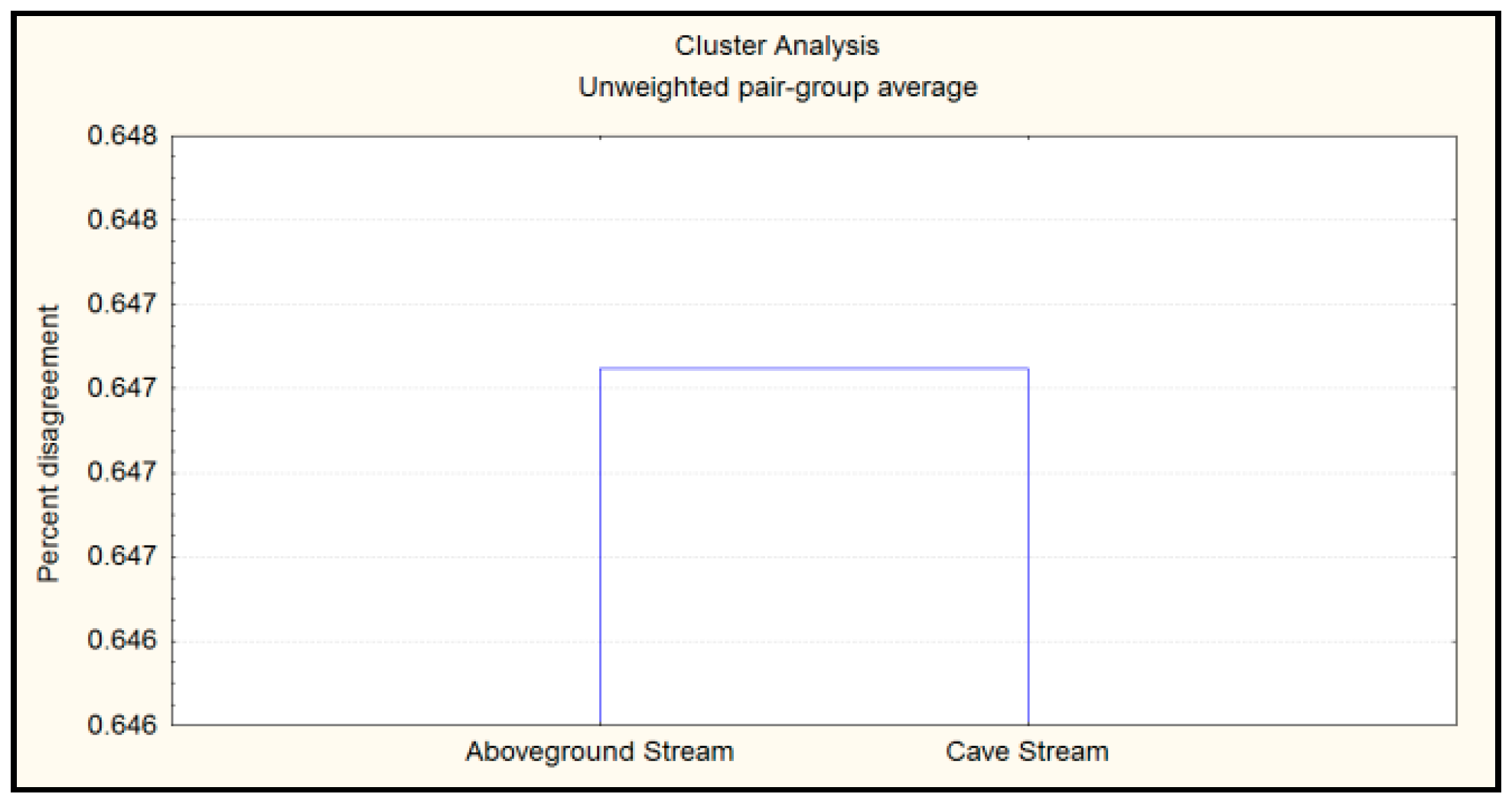
A cluster analysis (Figure 3) showed that 36 species were present in either sites or 35.29% (64.70% disagreement). The presence of similar species in both sites was indicative that the two stream systems are interconnected. The difference in the species composition could be attributed to the species sensitivity or tolerance to cave conditions.
The presence of phytoplanktons in the cave stream indicates a strong interconnectivity with surface streams. Phytoplanktons to develop will need sunlight which is readily available in cave streams [16].
3.8. Freshwater Shrimps
Initial identification based on external morphology indicates that the shrimps collected from sampling sites belong to two genera: Atyoida and Macrobrachium (Table 11). The Macrobrachium species was found in both inside and outside streams while the Atyoida species was limited to surface streamstream. Atyoida are seen mainly in riffles which contain shallower water [17], as observed in this study with Atyoidapilipes found in rapid flowing waters outside of the cave.
The presence of Macrobrachium species in both the cave and aboveground streams may indicate a connection between the stream systems. As Macrobarchium freshwatershrimps are not troglobitic species. Infact, they are considered as amphidromous [18].
4. Conclusions
There are reasons to believe that the surfacestream and the cave stream in the Torrijos Watershed Forest Reserve are interconnected as shown by both streams having common organisms (both freshwater shrimps and phytoplanktons). Phytoplanktons need sunlight to develop, which is absent in the cave, and therefore must be transported to the caves to be present. The freshwater shrimps found in the cave are not troglobitic and are considered amphidromous and therefore has found its way to the cave stream. Further, there seems to be a similar trend or correlation on the total suspended solids, sedimentation rates and amounts of nutrients (in particular phosphates) between the aboveground stream and the cave stream.
Although organic matter and nutrients from the aboveground landscape are needed for the sustenance of organisms in the cave ecosystem (the abundance of which are dependent on the connectivity of the two water systems), excessive siltation/sedimentation can ultimately threaten the water quality of cave streams. With the forest in the watershed area characterized as denuded, the threat is evident. The protection of the watershed and its landscape is imperative. The karst landscapes (which includes the forest/vegetation cover) work together to reduce soil erosion and pollution that will ultimately end up in the cave stream.
Author Contributions
Conceptualization, investigations of freshwater planktons and shrimps and writing—original draft, D.R.M.; supervision, R.O.D.d.L.; investigation of watershed, E.L.D.R.
Funding
This study was funded by the Commission on Higher Education—Faculty Development II (CHED-FDP II).
Acknowledgments
The permits to study the areas were granted by the Department of Environment and Natural Resources and the Local Government Units of Barangay Bonliw and Municipality of Torrijos. Ronald Atienza and Jovs Raza assisted in the fieldworks. The fund for the registration to participate in the 2018 International Conference on Sustainable Environmental Technologies was supported by the Philippines Commission on Higher Education which include the publication fee for the international journal.
Conflicts of Interest
The authors declare no conflict of interest.
References
- Mascareñas, D.R.; Demayo, C.G. Nutrient characterization of subterranean and aboveground streams in Marinduque, Philippines: Implications to the freshwater plankton and shrimp diversity. Sci. Int. 2017, 29, 827–831. [Google Scholar]
- Kiernan, K. Timber harvesting on karst lands: Some operational considerations and procedural requirements. ENDINS 1987, 13, 105–109. [Google Scholar]
- Strueber, A.M.; Criss, R.E. Origin and transport of dissolved chemicals in a karst watershed, Southwestern Illinois. J. Am. Water Resour. Assoc. 2005, 41, 267–290. [Google Scholar] [CrossRef]
- Criss, R.E.; Fernandes, S.A.; Winston, W.E. Isotopic, geochemical and biological tracing of the source of an impacted karst spring, Weldon Spring, Missouri. Environ. Forensics 2001, 2, 99–103. [Google Scholar] [CrossRef]
- Simon, K.S.; Pipan, T.; Culver, D.C. A conceptual model of the flow and distribution of organic carbon in caves. J. Cave Karst Stud. 2007, 69, 279–284. [Google Scholar]
- Shirota, A. The planktons of South-Vietnam: Freshwater and Marine Plankton; Overseas Technical Cooperation Agency: Tokyo, Japan, 1966. [Google Scholar]
- Chace, F.; Bruce, A.J. The Caridean Shrimps (Crustacea: Decapoda) of the Albatross Philippine Expedition 1907–1910, Part 6: Superfamily Palaemonoidea; Smithsonian Institution Press: Washington, DC, USA, 1993. [Google Scholar]
- Cai, Y.; Anker, A. On a collection of freshwater shrimps (Crustacea Decapoda Caridea) from the Philippines, with descriptions of five new species. Trop. Zool. 2004, 17, 233–266. [Google Scholar] [CrossRef] [Green Version]
- Marinduque Provincial Environment and Natural Resources Office. Protected Area Suitablity Assessment (PASA) Resource Basic Inventory (RBI) Report; Torrijos Watershed Forest Reserve: Barangay Bonliw, Torrijos, Marinduque; Marinduque Provincial Environment and Natural Resources Office: Marinduque, Philippines, 2013.
- Venarsky, M.P.; Benstead, J.P.; Huryn, A.D. Effects of organic matter and season on leaf litter colonization and breakdown in cave streams. Freshw. Biol. 2012, 57, 773–786. [Google Scholar] [CrossRef]
- Mueller, D.K.; Helsel, D.R. Nutrients in the Nation’s Waters—Too Much of a Good Thing? U.S.Geological Survey Circular 1136. National Water-Quality Assessment Program. 1999. Available online: http://water.usgs.gov/nawqa/circ-1136.html (accessed on 21 January 2017).
- Department of Environment and Natural Resources-Environmental Management Bureau. Revised Water Usage and Classification/Water Quality Criteria Amending Section Nos. 68 and 69, Chapter III of the 1978 NPCC Rules and Regulations; DENR Administrative Order No. 34 Series of 1990; Department of Environment and Natural Resources-Environmental Management Bureau: Quezon City, Philippines, 2009.
- PHILMINAQ. Mitigating Impacts from Aquaculture in the Philippines; Annex 2. European Commission-Cordis; European Commission: Brussels, Belgium, 2008. [Google Scholar]
- Iowa Department of Natural Resources. Water Quality Standards Review: Chloride, Sulfate and Total Dissolved Solids; Consultation Package; Iowa Department of Natural Resources: Des Moines, IA, USA, 2009; 79p.
- Zokaites, C. Living on Karst; Cave Conservancy of the Virginias: Glen Allen, VA, USA, 1997; 33p. [Google Scholar]
- Willoughby, L.C. Freshwater Biology; Pica Press: Great Britain, UK, 1977. [Google Scholar]
- Leberer, T.; Nelson, S.G. Factors affecting the distribution of Atyid shrimps in two tropical insular rivers. Pac. Sci. 2001, 55, 389–398. [Google Scholar] [CrossRef]
- Chen, R.T.; Tsai, C.F.; Tzeng, W.N. Freshwater prawns (Macrobrachium Bate, 1868) of Taiwan with special references to their biogeographical origins and dispersion routes. J. Crustacean Biol. 2009, 29, 232–244. [Google Scholar] [CrossRef]
Figure 1.
Sampling site in Pahu-an Cave and vicinity showing the surface stream and the remaining forest cover in the area (modified from Google Earth [2018] and Mines and Geoscience Bureau Geological Database Information System generated maps [http://gdis.mgb.gov.ph/mgbpublic]).
Figure 1.
Sampling site in Pahu-an Cave and vicinity showing the surface stream and the remaining forest cover in the area (modified from Google Earth [2018] and Mines and Geoscience Bureau Geological Database Information System generated maps [http://gdis.mgb.gov.ph/mgbpublic]).

Figure 2.
Pahu-an Cave profile (modified from the Marinduque Cave Assessment Team map, unpublished).
Figure 2.
Pahu-an Cave profile (modified from the Marinduque Cave Assessment Team map, unpublished).

Figure 3.
Phytoplankton cluster analysis.


Table 1.
Present landuse of the Torrijos Watershed Forest Reserve.
| Dominant Land-Use | Area Covered in Hectares |
|---|---|
| 1. Secondary forest/reforestation | 40.00 |
| 2. Karst forest | 35.00 |
| 3. Shrubs and brushes | 10.00 |
| 4. Coconut plantation/kaingin | 18.80 |
| Total | 103.80 |
Table 2.
Phosphate content (water).
| Sampling Site | Pahu-an Cave Stream (PO4-P ppm) | Aboveground Stream (PO4-P ppm) | Prob. | ||
|---|---|---|---|---|---|
| Mean | S.D. | Mean | S.D. | ||
| Upstream | 0.139 | 0.031 | 0.220 | 0.054 | 0.045 * |
| Midstream | 0.195 | 0.031 | 0.119 | 0.023 | 0.014 * |
| Downstream | 0.149 | 0.053 | 0.124 | 0.048 | 0.288 |
* significant.
Table 3.
Phosphate content (sediments).
| Sampling Site | Pahu-an Cave Stream (PO4-P ppm) | Aboveground Stream (PO4-P ppm) | Prob. | ||
|---|---|---|---|---|---|
| Mean | S.D. | Mean | S.D. | ||
| Upstream | 0.471 | 0.092 | 0.622 | 0.123 | 0.082 |
| Midstream | 0.491 | 0.161 | 0.511 | 0.128 | 0.001 * |
| Downstream | 0.556 | 0.023 | 0.833 | 0.038 | 0.0002 * |
* significant.
Table 4.
Ammonium content (water).
| Sampling Site | Pahu-an Cave Stream (NH3-N ppm) | Aboveground Stream (NH3-N ppm) | Prob. | ||
|---|---|---|---|---|---|
| Mean | S.D. | Mean | S.D. | ||
| Upstream | 0.092 | 0.011 | 0.005 | 0.003 | 0.010 * |
| Midstream | 0.012 | 0.007 | 0.015 | 0.008 | 0.325 |
| Downstream | 0.380 | 0.069 | 0.023 | 0.003 | 0.0004 * |
* significant.
Table 5.
Ammonium content (sediments).
| Sampling Site | Pahu-an Cave Stream (NH3-N ppm) | Aboveground Stream (NH3-N ppm) | Prob. | ||
|---|---|---|---|---|---|
| Mean | S.D. | Mean | S.D. | ||
| Upstream | 0.035 | 0.027 | 0.531 | 0.023 | 0.055 × 10⁻⁶ * |
| Midstream | 0.361 | 0.005 | 0.557 | 0.045 | 0.990 × 10⁻⁵ * |
| Downstream | 0.973 | 0.018 | 0.516 | 0.018 | 0.001 * |
* significant.
Table 6.
Sulfate content (water).
| Sampling Site | Pahu-an Cave Stream (SO4-S ppm) | Aboveground Stream (SO4-S ppm) | Prob. | ||
|---|---|---|---|---|---|
| Mean | S.D. | Mean | S.D. | ||
| Upstream | 0.321 | 0.257 | 0.020 | 0.979 | 0.115 |
| Midstream | 1.643 | 0.426 | 7.309 | 0.279 | 0.000 * |
| Downstream | 0.507 | 0.279 | 6.752 | 0.836 | 0.000 * |
* significant.
Table 7.
Sulfate content (sediments).
| Sampling Site | Pahu-an Cave Stream (SO4-S ppm) | Aboveground Stream (SO4-S ppm) | Prob. | ||
|---|---|---|---|---|---|
| Mean | S.D. | Mean | S.D. | ||
| Upstream | 4.926 | 0.317 | 2.697 | 0.426 | 0.025 * |
| Midstream | 7.806 | 0.042 | 1.025 | 0.851 | 0.023 * |
| Downstream | 6.659 | 0.580 | 2.232 | 0.126 | 0.001 * |
* significant.
Table 8.
Total suspended solids (TSS).
| Sampling Site | Pahu-an Cave (g/L) | Aboveground Stream (g/L) |
|---|---|---|
| Upstream | 0.139 | 0.162 |
| Midstream | 0.160 | 0.133 |
| Downstream | 0.095 | 0.132 |
Table 9.
Sedimentation rate.
| Sampling Site | Pahu-an Cave (g/m2/day) | Aboveground Stream (g/m2/day) | Prob. | ||
|---|---|---|---|---|---|
| Mean | S.D. | Mean | S.D. | ||
| Upstream | 17.828 | 0.468 | 27.825 | 0.713 | 0.052 |
| Midstream | 7.439 | 0.997 | 11.786 | 0.178 | 0.103 |
| Downstream | 17.279 | 0.607 | 30.006 | 0.529 | 0.007 * |
* significant.
Table 10.
Phytoplanktons.
| Species | Density per Liter | |
|---|---|---|
| Cave | Surface | |
| Stream | Stream | |
| Anabaena sp. 1 | 8250 | 3750 |
| Anabaena sp. 2 | 550 | 200 |
| Ankistrodesmus sp. 1 | 100 | 100 |
| Ankistrodesmus sp. 2 | 0 | 50 |
| Aphanizomenon sp. | 100 | 0 |
| Asterionella sp. | 50 | 0 |
| Batrachospermum sp. | 50 | 0 |
| Chodatella sp. | 200 | 0 |
| Cladophora sp. | 150 | 0 |
| Coleps sp. | 0 | 50 |
| Cosmarium sp. | 200 | 0 |
| Craticula sp. | 50 | 0 |
| Cupidothrix sp. | 50 | 0 |
| Cylindrocystis sp. | 0 | 50 |
| Diatom (unidentified) | 50 | 0 |
| Dictyosphaerium sp. | 50 | 0 |
| Enteromorpha sp. | 50 | 0 |
| Euglena sp. 1 | 50 | 0 |
| Euglena sp. 2 | 100 | 50 |
| Eunotia sp. | 0 | 50 |
| Fragilaria sp. | 50 | 0 |
| Gomphonema sp. 2 | 0 | 50 |
| Gomphonema sp. 1 | 50 | 0 |
| Hydroctyon sp. | 4700 | 1050 |
| Hydrosera sp. | 0 | 50 |
| Lemanea sp. | 50 | 0 |
| Lyngbya sp. | 1150 | 450 |
| Melosira sp. | 50 | 0 |
| Merismopedia sp. | 850 | 150 |
| Microcystis sp. 5 | 50 | 0 |
| Microcystis sp. 1 | 50 | 50 |
| Microcystis sp. 2 | 50 | 0 |
| Microcystis sp. 3 | 50 | 50 |
| Microcystis sp. 4 | 50 | 200 |
| Monoraphidium sp. | 50 | 0 |
| Monoraphidium sp. | 0 | 50 |
| Mugeotia sp. 1 | 50 | 0 |
| Mugeotia sp. 2 | 150 | 50 |
| Navicula sp. 2 | 0 | 100 |
| Navicula sp. 1 | 2550 | 0 |
| Nitzschia sp. 2 | 150 | 300 |
| Nitzschia sp. 3 | 400 | 50 |
| Nitzschia sp. 6 | 50 | 0 |
| Nodularia sp. | 0 | 50 |
| Nostoc sp. | 50 | 1350 |
| Oocystis sp. 2 | 100 | 300 |
| Oocytis sp. | 150 | 100 |
| Oscillatoria sp. | 100 | 100 |
| Scenedesmus sp. | 0 | 150 |
| Stigeoclarium sp. | 50 | 0 |
| Synechoccus sp. | 700 | 0 |
| Synedra sp. 3 | 100 | 0 |
| Synedra sp. 4 | 150 | 100 |
| Synedra sp. 5 | 50 | 0 |
| Synedra sp. 6 | 50 | 200 |
| Synedra sp. 7 | 50 | 100 |
| Synedra sp. 7 | 50 | 50 |
| Synedra sp. 8 | 0 | 50 |
| Synedra sp. 1 | 50 | 0 |
| Synedra sp. 2 | 50 | 0 |
| Trachelomonas sp. | 100 | 200 |
| Ulothrix sp. | 50 | 50 |
| Unidentified sp. 1 | 50 | 50 |
| Unidentified sp. 2 | 50 | 0 |
| Unidentified sp. 3 | 50 | 100 |
| Unidentified sp. 4 | 200 | 50 |
| Unidentified sp. 5 | 50 | 0 |
| Unidentified sp. 6 | 17,800 | 6450 |
| Unidentified sp. 7 | 50 | 0 |
| Unidentified sp. 8 | 100 | 50 |
| Unidentified sp. 9 | 50 | 0 |
| Unidentified sp. 10 | 50 | 0 |
| Unidentified sp. 11 | 50 | 500 |
| Unidentified sp. 12 | 50 | 50 |
| Unidentified sp. 13 | 100 | 0 |
| Unidentified sp. 14 | 50 | 0 |
| Unidentified sp. 15 | 100 | 100 |
| Unidentified sp. 16 | 100 | 50 |
| Unidentified sp. 17 | 0 | 50 |
| Unidentified sp. 18 | 300 | 50 |
| Unidentified sp. 19 | 50 | 0 |
| Unidentified sp. 20 | 100 | 100 |
| Unidentified sp. 21 | 50 | 0 |
| Unidentified sp. 22 | 50 | 0 |
| Unidentified sp. 23 | 0 | 150 |
| Unidentified sp. 24 | 0 | 50 |
| Unidentified sp. 25 | 0 | 2100 |
| Unidentified sp. 26 | 0 | 150 |
| Unidentified sp. 27 | 0 | 2050 |
| Unidentified sp. 28 | 100 | 600 |
| Unidentified sp. 29 | 50 | 300 |
| Unidentified sp. 30 | 0 | 50 |
| Unidentified sp. 31 | 0 | 100 |
| Unidentified sp. 32 | 0 | 50 |
| Unidentified sp. 33 | 0 | 50 |
| Unidentified sp. 34 | 0 | 100 |
| Unidentified sp. 35 | 50 | 0 |
| Unidentified sp. 36 | 100 | 0 |
| Unidentified sp. 37 | 0 | 50 |
| Unidentified sp. 38 | 50 | 0 |
| Unidentified sp. 39 | 50 | 0 |
| Unidentified sp. 40 | 0 | 50 |
| Total Abundance | 42,300 | 23,150 |
| Species Richness | 78 | 60 |
Table 11.
Freshwater shrimp species richness.
| Species | Cave Stream | Aboveground Stream |
|---|---|---|
| Macrobrachium lar | + | + |
| Atyoidapilipes | − | + |
| Species Richness | 1 | 2 |
© 2019 by the authors. Licensee MDPI, Basel, Switzerland. This article is an open access article distributed under the terms and conditions of the Creative Commons Attribution (CC BY) license (http://creativecommons.org/licenses/by/4.0/).
Share and Cite
MDPI and ACS Style
Mascareñas, D.R.; de Leon, R.O.D.; Delos Reyes, E.L. Watershed and Pahu-anCave Stream Interconnectivity in Bonliw, Torrijos, Marinduque, Philippines. Environments 2019, 6, 11. https://0-doi-org.brum.beds.ac.uk/10.3390/environments6020011
AMA Style
Mascareñas DR, de Leon ROD, Delos Reyes EL. Watershed and Pahu-anCave Stream Interconnectivity in Bonliw, Torrijos, Marinduque, Philippines. Environments. 2019; 6(2):11. https://0-doi-org.brum.beds.ac.uk/10.3390/environments6020011
Chicago/Turabian StyleMascareñas, Doreen R., Roy Olsen D. de Leon, and Efren L. Delos Reyes. 2019. "Watershed and Pahu-anCave Stream Interconnectivity in Bonliw, Torrijos, Marinduque, Philippines" Environments 6, no. 2: 11. https://0-doi-org.brum.beds.ac.uk/10.3390/environments6020011
Note that from the first issue of 2016, this journal uses article numbers instead of page numbers. See further details here.