
Sand Trapping Fences as a Nature-Based Solution for Coastal Protection: An International Review with a Focus on Installations in Germany

 , ,
, , 
Abstract
:1. Introduction
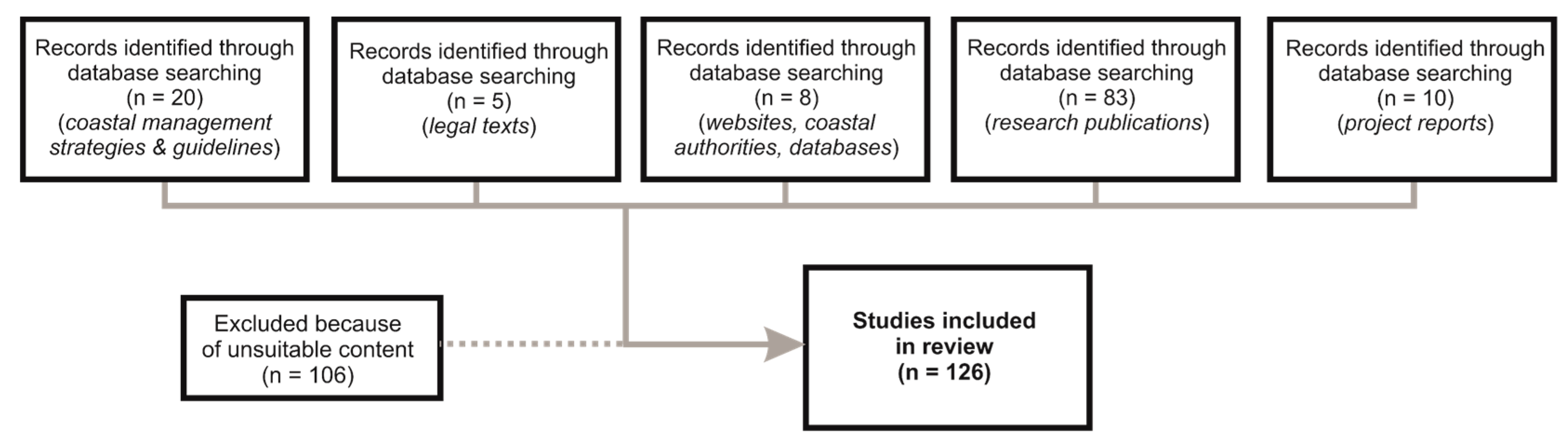
2. Methodology
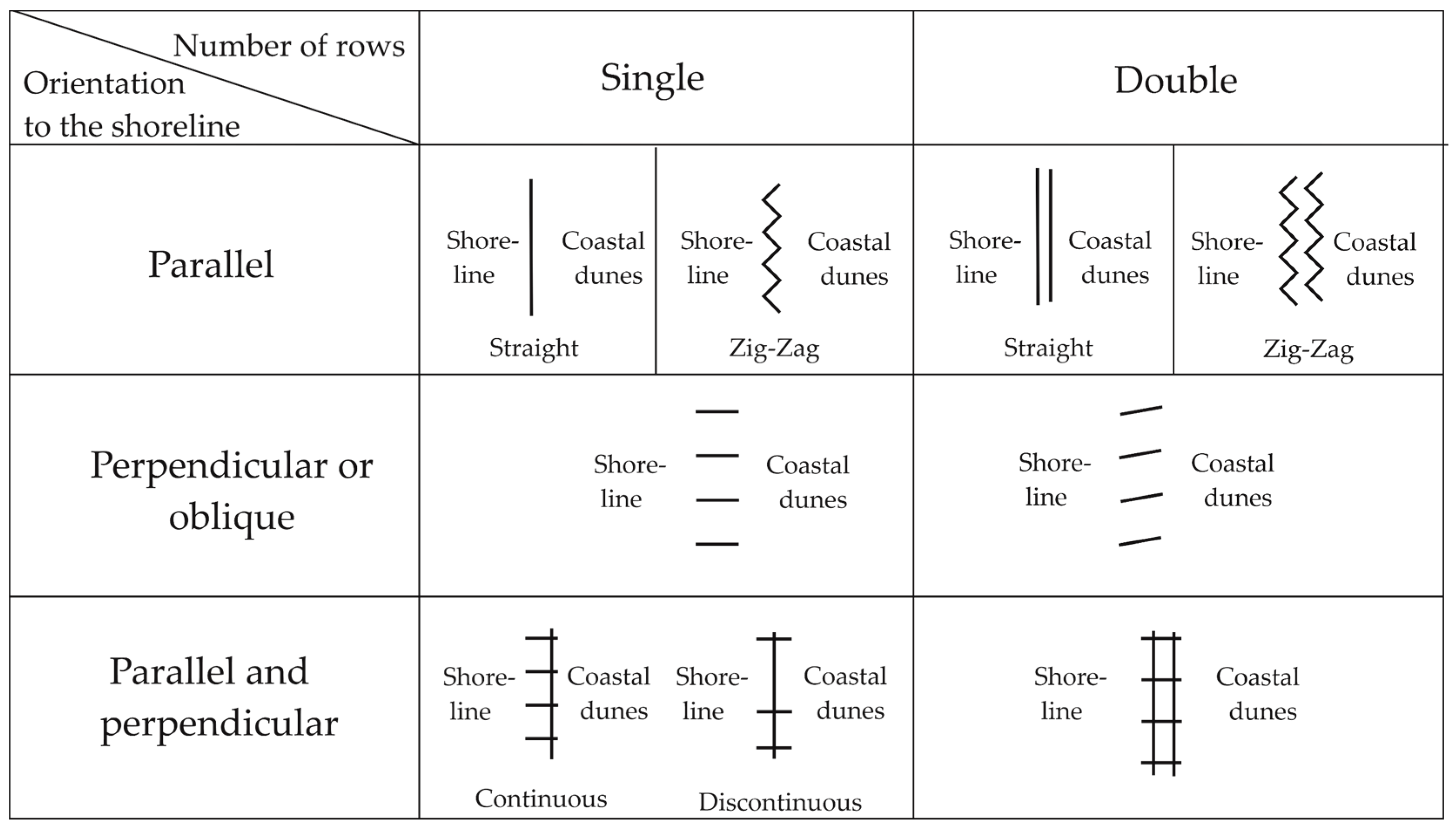
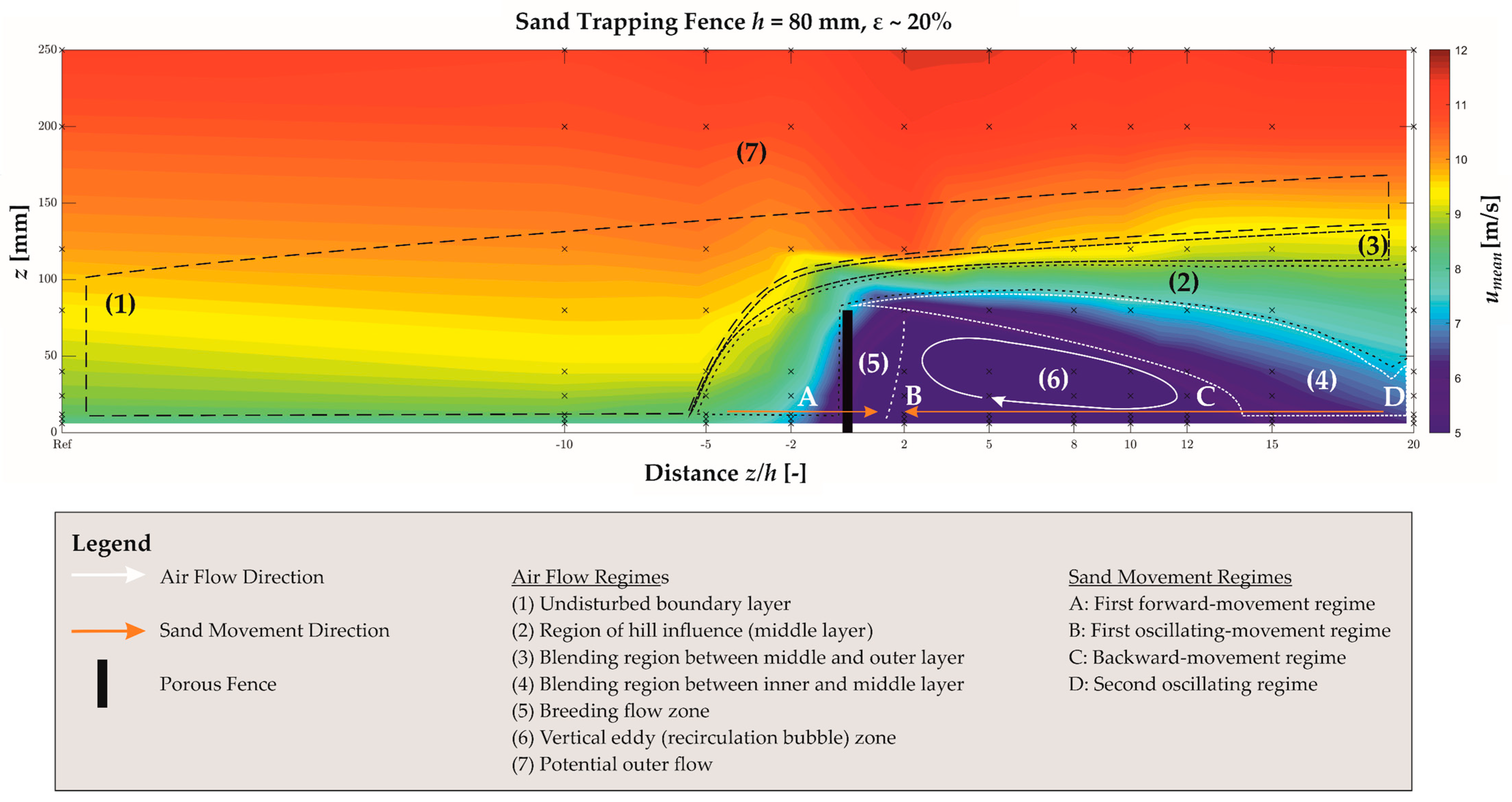
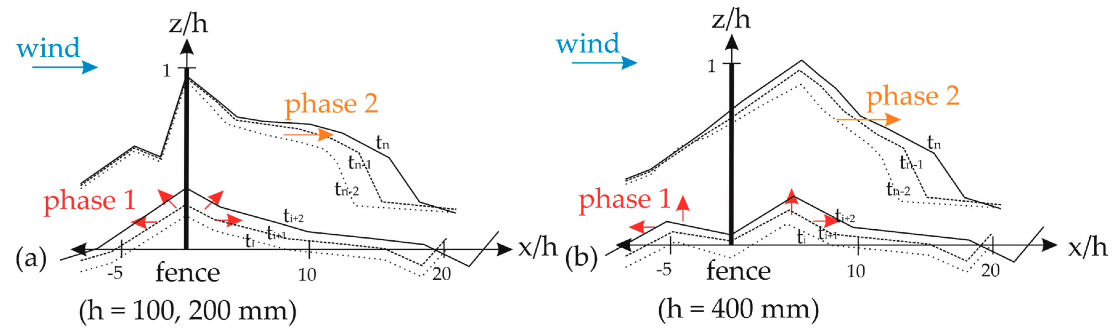
3. General Aerodynamic and Morphodynamic Conditions around a Porous Fence
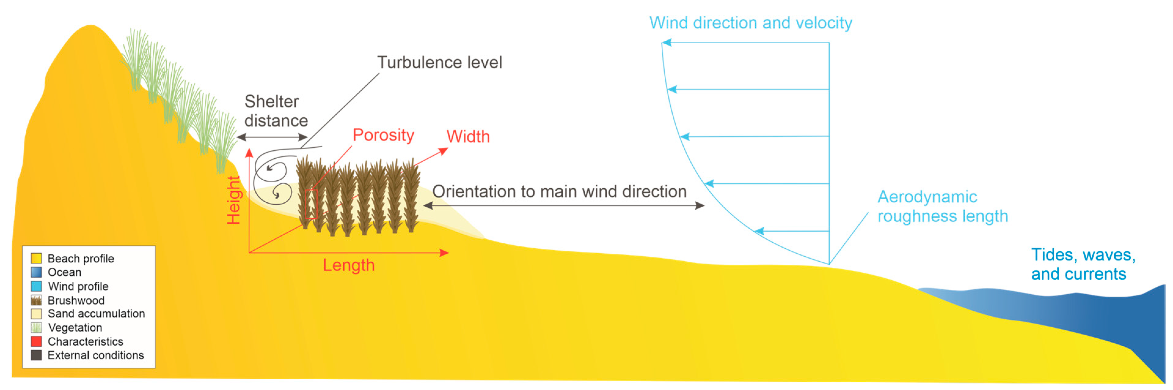
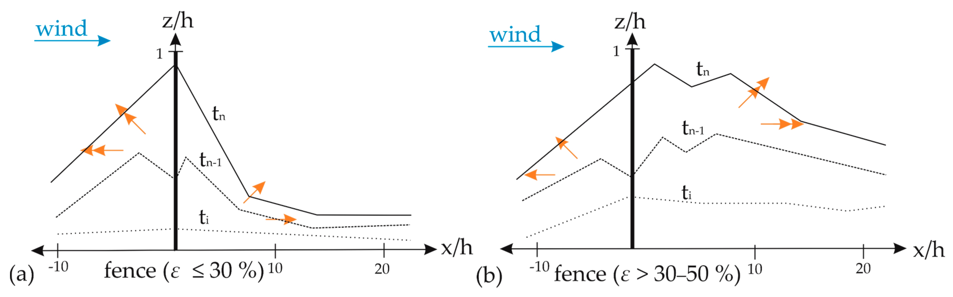
4. Influencing Parameters of the Aerodynamic and Morphodynamic Conditions
4.1. Fence Height
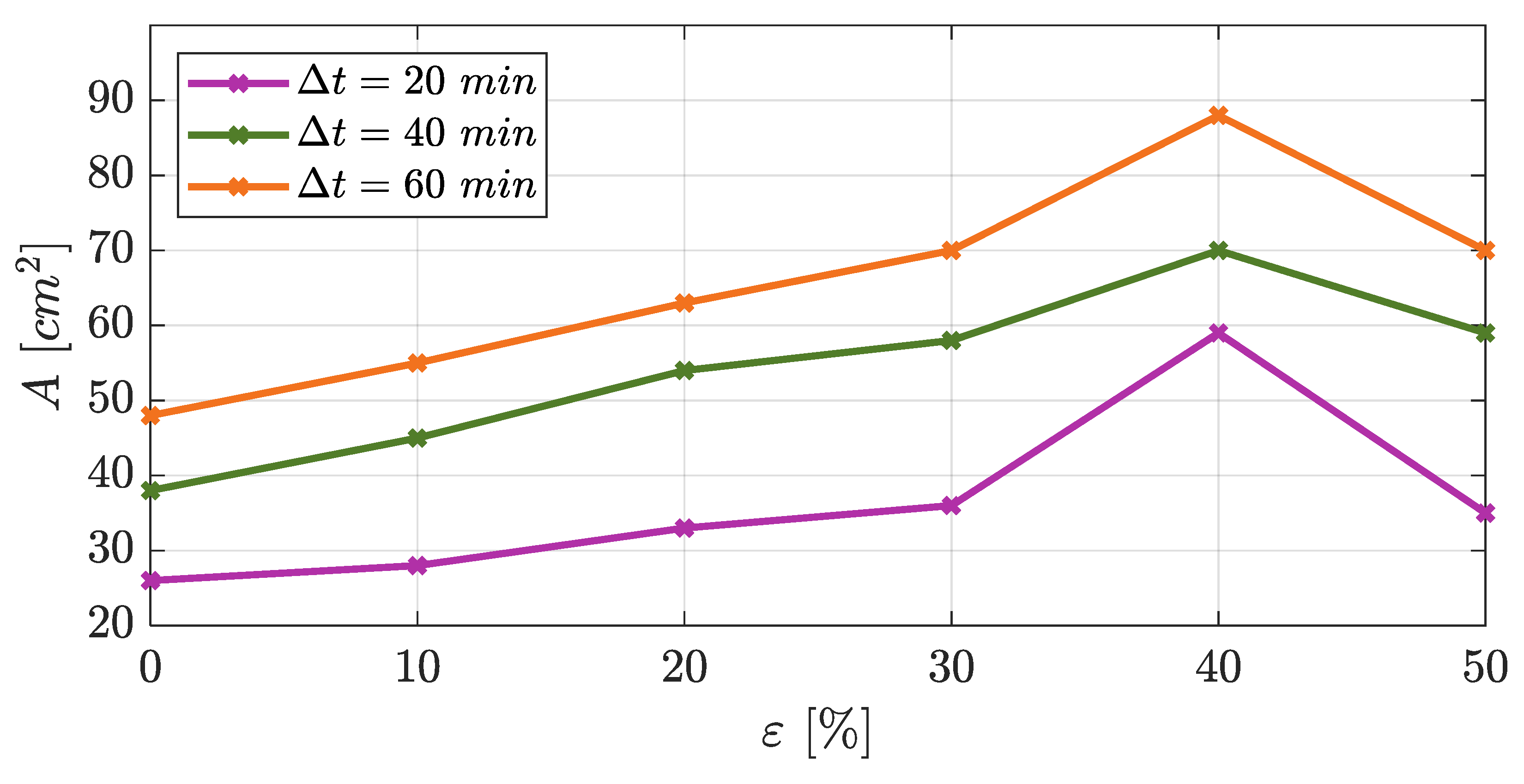
4.2. Fence Porosity
5. Efficiency of Sand Trapping Fences to Trap Sediment
6. Sand Trapping Fences in Coastal Regions Worldwide and Germany
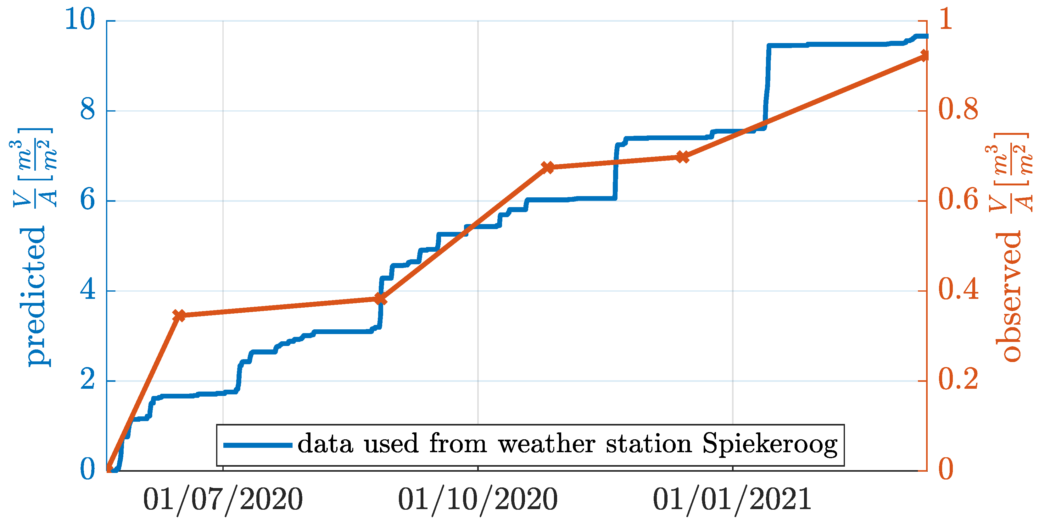
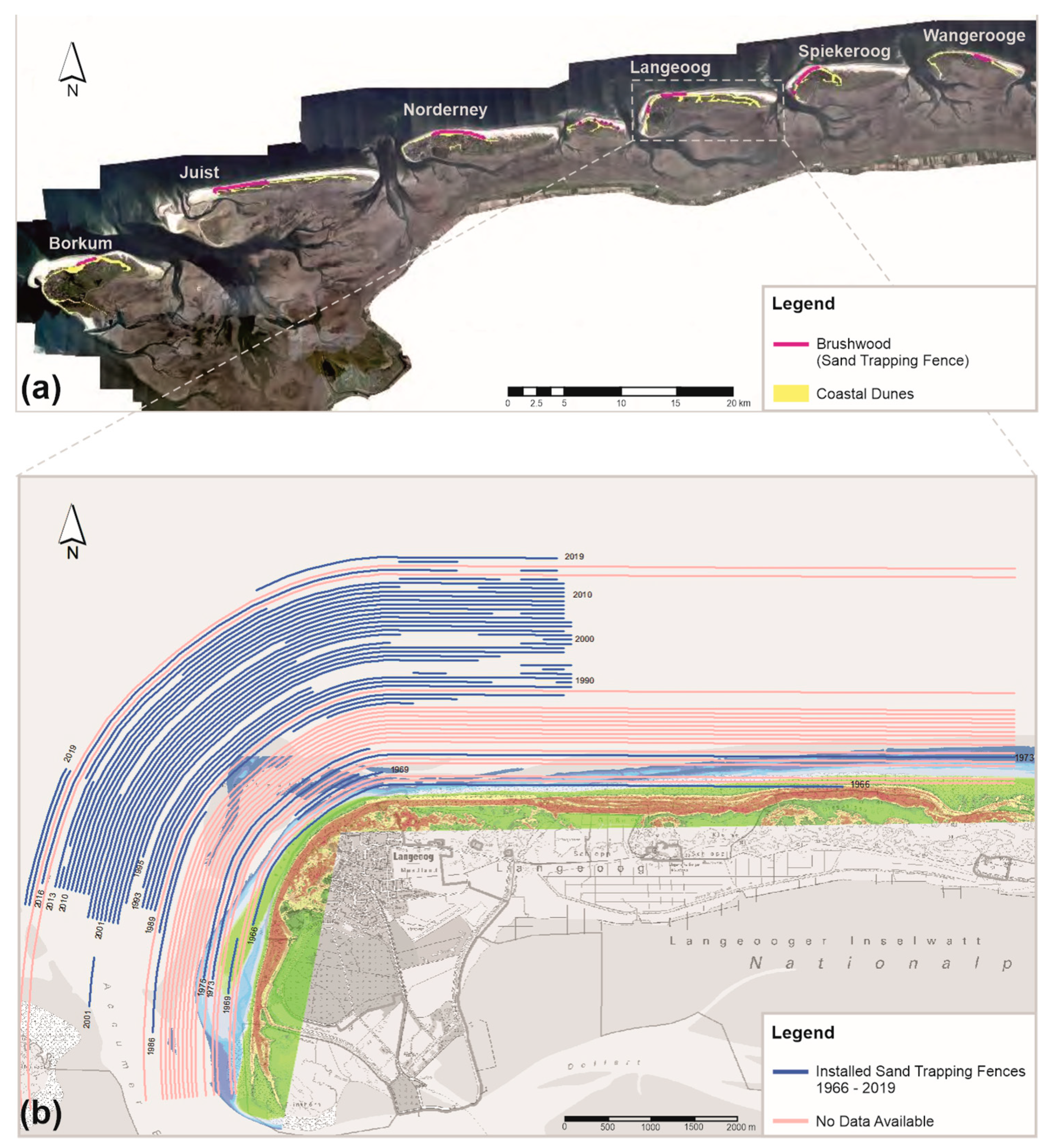
6.1. Sand Trapping Fences at the German Coast
6.1.1. North Sea
6.1.2. Baltic Sea
7. Conclusions
Author Contributions
Funding
Acknowledgments
Conflicts of Interest
References
- Harff, J.; Björck, S.; Hoth, P. The Baltic Sea Basin; Springer: Berlin, Germany, 2011; ISBN 978-3-642-17220-5. [Google Scholar]
- Keijsers, J.; de Groot, A.V.; Riksen, M. Vegetation and sedimentation on coastal foredunes. Geomorphology 2015, 228, 723–734. [Google Scholar] [CrossRef]
- Hesp, P. Dune Coasts. In Treatise on Estuarine and Coastal Science: Estuarine and Coastal Geology and Geomorphology—A Synthesis; Wolanski, E., McLusky, D., Eds.; Elsevier: Amsterdam, The Netherlands, 2011; pp. 193–221. ISBN 9780080878850. [Google Scholar]
- DeVries, S.; Southgate, H.N.; Kanning, W.; Ranasinghe, R. Dune behavior and aeolian transport on decadal timescales. Coast. Eng. 2012, 67, 41–53. [Google Scholar] [CrossRef]
- National Aeronautics and Space Administration. Living Ocean. Available online: https://science.nasa.gov (accessed on 20 August 2021).
- Wasserwirtschaft, N.L.; Naturschutz, K. Lower Saxony Water Management, Coastal Protection, and Conservation Agency; Gen. Küstenschutz Niedersachsen: Bremen, Germany, 2007. [Google Scholar]
- Arens, S.M.; Mulder, J.P.; Slings, Q.L.; Geelen, L.H.; Damsma, P. Dynamic dune management, integrating objectives of nature development and coastal safety: Examples from the Netherlands. Geomorphology 2013, 199, 205–213. [Google Scholar] [CrossRef]
- Morris, R.L.; Konlechner, T.M.; Ghisalberti, M.; Swearer, S.E. From grey to green: Efficacy of eco-engineering solutions for nature-based coastal defence. Glob. Chang. Biol. 2018, 24, 1827–1842. [Google Scholar] [CrossRef] [PubMed]
- Scheres, B.; Schüttrumpf, H. Nature-Based Solutions in Coastal Research—A New Challenge for Coastal Engineers? Viet, N.T., Xiping, D., Tung, T.T., Eds.; Springer: Singapore, 2020. [Google Scholar]
- Schoonees, T.; Gijón-Mancheño, A.; Scheres, B.; Bouma, T.J.; Silva, R.; Schlurmann, T.; Schüttrumpf, H. Hard Structures for Coastal Protection, Towards Greener Designs. Estuaries Coasts 2019, 42, 1709–1729. [Google Scholar] [CrossRef]
- De Jong, B.; Keijsers, J.G.; Riksen, M.J.; Krol, J.; Slim, P.A. Soft Engineering vs. a Dynamic Approach in Coastal Dune Management: A Case Study on the North Sea Barrier Island of Ameland, The Netherlands. J. Coast. Res. 2014, 30, 670. [Google Scholar] [CrossRef]
- Nolet, C.; van Puijenbroek, M.; Suomalainen, J.; Limpens, J.; Riksen, M. UAV-imaging to model growth response of marram grass to sand burial: Implications for coastal dune development. Aeolian Res. 2018, 31, 50–61. [Google Scholar] [CrossRef]
- Eichmanns, C.; Schüttrumpf, H. Investigating Changes in Aeolian Sediment Transport at Coastal Dunes and Sand Trapping Fences: A Field Study on the German Coast. JMSE 2020, 8, 1012. [Google Scholar] [CrossRef]
- Staudt, F.; Gijsman, R.; Ganal, C.; Mielck, F.; Wolbring, J.; Hass, H.C.; Goseberg, N.; Schüttrumpf, H.; Schlurmann, T.; Schimmels, S. The sustainability of beach nourishments: A review of nourishment and environmental monitoring practice. J. Coast. Conserv. 2021, 25, 1–24. [Google Scholar] [CrossRef]
- Thorenz, F. Coastal Flood Defence and Coastal Protection along the North Sea Coast of Niedersachsen. Die Küste 2008, 74, 158–169. [Google Scholar]
- Charbonneau, B.R.; Dohner, S.M.; Wnek, J.P.; Barber, D.; Zarnetske, P.; Casper, B.B. Vegetation effects on coastal foredune initiation: Wind tunnel experiments and field validation for three dune-building plants. Geomorphology 2021, 378, 107594. [Google Scholar] [CrossRef]
- Li, B.; Sherman, D.J. Aerodynamics and morphodynamics of sand fences: A review. Aeolian Res. 2015, 17, 33–48. [Google Scholar] [CrossRef]
- Zhang, N.; Kang, J.-H.; Lee, S.-J. Wind tunnel observation on the effect of a porous wind fence on shelter of saltating sand particles. Geomorphology 2010, 120, 224–232. [Google Scholar] [CrossRef]
- Grafals-Soto, R.; Nordstrom, K. Sand fences in the coastal zone: Intended and unintended effects. Environ. Manag. 2009, 44, 420–429. [Google Scholar] [CrossRef] [PubMed]
- Dong, Z.; Luo, W.; Qian, G.; Wang, H. A wind tunnel simulation of the mean velocity fields behind upright porous fences. Agric. For. Meteorol. 2007, 146, 82–93. [Google Scholar] [CrossRef]
- Dong, Z.; Chen, G.; He, X.; Han, Z.; Wang, X. Controlling blown sand along the highway crossing the Taklimakan Desert. J. Arid Environ. 2004, 57, 329–344. [Google Scholar] [CrossRef]
- Hotta, S.; Horikawa, K. Function of Sand Fence Placed in Front of Embankment. In Proceedings of the 22nd Conference on Coastal Engineering, Delft, The Netherlands, 2–6 July 1990; pp. 2754–2767. [Google Scholar] [CrossRef]
- Gillies, J.A.; Etyemezian, V.; Nikolich, G.; Glick, R.; Rowland, P.; Pesce, T.; Skinner, M. Effectiveness of an array of porous fences to reduce sand flux: Oceano Dunes, Oceano CA. J. Wind Eng. Ind. Aerodyn. 2017, 168, 247–259. [Google Scholar] [CrossRef]
- Hotta, S.; Harikai, S. State-of-the-art in Japan on controlling windblown sand on beaches. In Proceedings of the 32nd Conference on Coastal Engineering, Shanghai, China, 30 June–7 July 2010. [Google Scholar]
- Adriani, M.J.; Terwindt, J. Sand Stabilization and Dune Building. Rijkswaterstaat Commun. 1974, 19, 1–69. [Google Scholar]
- Ning, Q.; Li, B.; Ellis, J.T. Fence height control on sand trapping. Aeolian Res. 2020, 46, 100617. [Google Scholar] [CrossRef]
- O’Connel, J. Coastal Dune Protection & Restoration: Using ‘Cape’ American Beach Grass and Fencing. Available online: https://www.whoi.edu (accessed on 15 October 2021).
- Gerhardt, P. Handbuch des Deutschen Dünenbaus: Im Auftrage des Kgl. Preuss. Ministeriums der Öffentlichen Arbeiten; Paul Parey: Berlin, Germany, 1990. [Google Scholar]
- Eichmanns, C.; Schüttrumpf, H. Influence of Sand Trapping Fences on Dune Toe Growth and Its Relation with Potential Aeolian Sediment Transport. JMSE 2021, 9, 850. [Google Scholar] [CrossRef]
- Itzkin, M.; Moore, L.J.; Ruggiero, P.; Hacker, S.D. The effect of sand fencing on the morphology of natural dune systems. Geomorphology 2020, 352, 106995. [Google Scholar] [CrossRef]
- Yu, Y.; Zhang, K.; An, Z.; Wang, T.; Hu, F. The blocking effect of the sand fences quantified using wind tunnel simulations. J. Mt. Sci. 2020, 17, 2485–2496. [Google Scholar] [CrossRef]
- Bofah, K.K.; Al-Hinai, K.G. Field tests of porous fences in the regime of sand-laden wind. J. Wind Eng. Ind. Aerodyn. 1986, 23, 309–319. [Google Scholar] [CrossRef]
- Lee, S.-J.; Kim, H.-B. Velocity field measurements of flow around a triangular prism behind a porous fence. J. Wind Eng. Ind. Aerodyn. 1998, 77–78, 521–530. [Google Scholar] [CrossRef]
- Lee, S.-J.; Kim, H.-B. Laboratory measurements of velocity and turbulence field behind porous fences. J. Wind Eng. Ind. Aerodyn. 1999, 80, 311–326. [Google Scholar] [CrossRef]
- Wang, T.; Qu, J.; Ling, Y.; Liu, B.; Xiao, J. Shelter effect efficacy of sand fences: A comparison of systems in a wind tunnel. Aeolian Res. 2018, 30, 32–40. [Google Scholar] [CrossRef]
- Ruz, M.-H.; Anthony, E.J. Sand trapping by brushwood fences on a beach-foredune contact: The primacy of the local sediment budget. Zeit Geo Supp. 2008, 52, 179–194. [Google Scholar] [CrossRef]
- Anthony, E.J.; Vanhee, S.; Ruz, M.-H. An assessment of the impact of experimental brushwood fences on foredune sand accumulation based on digital elelvation models. Ecol. Eng. 2007, 31, 41–46. [Google Scholar] [CrossRef]
- Martin, G.A. Fences, Gates, and Bridges: A Practical Manual; A.C. Hood: Brattleboro, VT, USA, 1992; ISBN 0911469087. [Google Scholar]
- Primack, M.L. Farm Fencing in the Nineteenth Century. J. Econ. Hist. 1969, 29, 287–291. [Google Scholar] [CrossRef]
- Hewes, L.; Hewes, L. Early Fencing on the Western Margin of the Prairie. Ann. Assoc. Am. Geogr. 1981, 71, 499–527. [Google Scholar] [CrossRef]
- Pickard, J. Post and Rail Fences: Derivation, Development, and Demise of Rural Technology in Colonial Australia. Agric. Hist. 2005, 79, 27–49. [Google Scholar] [CrossRef] [Green Version]
- Tigges, P. Sandfangzäune am Hauptstrand. Available online: http://www.inselrundgang.de (accessed on 29 October 2021).
- Lima, I.A.; Araújo, A.D.; Parteli, E.J.R.; Andrade, J.S.; Herrmann, H.J. Optimal array of sand fences. Sci. Rep. 2017, 45148. [Google Scholar] [CrossRef] [Green Version]
- Grafals-Soto, R. Understanding the Effects of Sand Fence Usage and the Resulting Landscape, Landform and Vegetation Patterns: A New Jersey Example. Ph.D. Thesis, The State University of New Jersey, New Brunswick, NJ, USA, 2010. [Google Scholar]
- Wang, T.; Qu, J.; Ling, Y.; Xie, S.; Xiao, J. Wind tunnel test on the effect of metal net fences on sand flux in a Gobi Desert, China. J. Arid Land 2017, 9, 888–899. [Google Scholar] [CrossRef] [Green Version]
- Plate, E.J. The aerodynamics of shelter belts. Agric. Meteorol. 1971, 8, 203–222. [Google Scholar] [CrossRef]
- Judd, M.J.; Raupach, M.R.; Finnigan, J.J. A wind tunnel study of turbulent flow around single and multiple windbreaks, part I: Velocity fields. Boundary Layer Meteorol. 1996, 80, 127–165. [Google Scholar] [CrossRef]
- Dong, Z.; Qian, G.; Luo, W.; Wang, H. Threshold velocity for wind erosion: The effects of porous fences. Environ. Geol. 2006, 51, 471–475. [Google Scholar] [CrossRef]
- Finney, E.A. Snow Drift Control by Highway Design; Michigan State University: E. Lansing, Michigan, USA, 1939; No. 86. [Google Scholar]
- Gloyne, R.W. Some Effects of Shelterbelts upon Local and Micro Climate. Forestry 1954, 27, 85–95. [Google Scholar] [CrossRef]
- Bodrov, B. Influence of Shelterbelts on the Micro-Climate of the Adjoining Territory; Translation U.S. For. Servo No. 164; Journal of forestry: Moscow, Russia, 1935. [Google Scholar]
- Hallberg, S. Some Investigations on Snow Fences: Statens Väginstitut, Meddelande 67; Stockholms Stadsbibliotek: Stockholm, Sweden, 1943. [Google Scholar]
- Dyunin, A.K. The Analytic Determination of the Surface Wind Velocity behind Open Snow Fences: (Translated from Russian by Israel Program for Scientific Translations); U.S. Department of Commerce: Washington, DC, USA, 1964; p. 17.
- Plate, E.J.; Lin, C.W. The Velocity Field Downstream from a Two-Dimensional Modell Hill: Final Report, Part I; US Army Material Agency: Redstone Arsenal, AL, USA, 1965; Contract DA-AMC-36-039-63-G7.
- Raine, J.K.; Stevenson, D.C. Wind protection by model fences in a simulated atmospheric boundary layer. J. Wind Eng. Ind. Aerodyn. 1977, 2, 159–180. [Google Scholar] [CrossRef]
- Wilson, J.D. Numerical studies of flow through a windbreak. J. Wind Eng. Ind. Aerodyn. 1985, 21, 119–154. [Google Scholar] [CrossRef]
- Wilson, J.D.; Swaters, G.E.; Ustina, F. A perturbation analysis of turbulent flow through a porous barrier. Q. J. R. Met. Soc. 1990, 116, 989–1004. [Google Scholar] [CrossRef]
- Perera, M. Shelter behind two-dimensional solid and porous fences. J. Wind Eng. Ind. Aerodyn. 1981, 8, 93–104. [Google Scholar] [CrossRef]
- Cornelis, W.M.; Gabriels, D. Optimal windbreak design for wind-erosion control. J. Arid Environ. 2005, 61, 315–332. [Google Scholar] [CrossRef]
- Dalyander, P.S.; Mickey, R.C.; Passeri, D.L.; Plant, N.G. Development and Application of an Empirical Dune Growth Model for Evaluating Barrier Island Recovery from Storms. JMSE 2020, 8, 977. [Google Scholar] [CrossRef]
- Houser, C.; Wernette, P.; Rentschlar, E.; Jones, H.; Hammond, B.; Trimble, S. Post-storm beach and dune recovery: Implications for barrier island resilience. Geomorphology 2015, 234, 54–63. [Google Scholar] [CrossRef]
- Savage, R.P.; Woodhouse, W.W. Creation and Stabilization of Coastal Barrier Dunes. In Proceedings of the 11th International Conference on Coastal Engineering, London, UK, September 1968; US Coastal Engineering Research Center: London, UK; pp. 671–700. [Google Scholar] [CrossRef]
- Manohar, M.; Bruun, P. Mechanics of dune growth by sand fences. Dock Harb. Auth. 1970, 51, 243–252. [Google Scholar]
- Chen, B.; Cheng, J.; Xin, L.; Wang, R. Effectiveness of hole plate-type sand barriers in reducing aeolian sediment flux: Evaluation of effect of hole size. Aeolian Res. 2019, 38, 1–12. [Google Scholar] [CrossRef]
- Bagnold, R.A. The movement of desert sand. Proc. R. Soc. Lond. Ser. A Math. Phys. Sci. 1936, 157, 594–620. [Google Scholar] [CrossRef]
- Bagnold, R.A. The Physics of Blown Sand and Desert Dunes, 2nd ed.; Methuen: London, UK, 1954. [Google Scholar]
- Van Rijn, L.C.; Strypsteen, G. A fully predictive model for aeolian sand transport. Coast. Eng. 2019, 156. [Google Scholar] [CrossRef]
- Van Rijn, L.C. Aeolian Transport over a Flat Sediment Surface. 2019. Available online: www.leovanrijn-sediment.com (accessed on 10 August 2021).
- Nickling, W.G.; McKenna Neumann, C. Aeolian Sediment Transport. In Geomorphology of Desert Environments; University of Guelph: Guelph, ON, Canada, 2009. [Google Scholar]
- Strypsteen, G. Monitoring and Modelling Aeolian Sand Transport at the Belgian Coast. Ph.D. Thesis, KU Leuven, Brugge, Belgium, 2019. [Google Scholar]
- Nickling, W.G.; Davidson-Arnott, R. Aeolian Sediment Transport on Beaches and Coastal Sand Dunes. In Proceedings of the Symposium on Coastal Sand Dunes 1990, Guelph, ON, Canada, 12–14 September 1990; pp. 1–35. [Google Scholar]
- Hinrichsen, A.M. Biotechnischer Küstenschutz auf Sylt (und Föhr): Presentation within Project Support Group of ProDune. Available online: https://www.schleswig-holstein.de/DE/Fachinhalte/K/kuestenschutz_fachplaene/Sylt/3_3_biotechnik.html(accessed on 24 June 2021).
- Landesbetrieb für Küstenschutz. Nationalpark und Meeresschutz Schleswig-Holstein (LKN-SH); Fachplan Küstenschutz Sylt, Biotechnischer Küstenschutz: Schleswig-Holstein, Germany, 2016. [Google Scholar]
- Niedersächsischer Landesbetrieb für Wasserwirtschaft, Küsten- und Naturschutz (Lower Saxony Water Management, Coastal Protection, and Conservation Agency); Generalplan Küstenschutz Niedersachen: Hannover, Germany, 2010.
- Erchinger, H. Schutz sandiger Küsten in Abhängigkeit vom Schutzdünen-Strand-Profil. In Proceedings of the 14th Conference on Coastal Engineering, Copenhagen, Denmark, 24–28 June 1974; pp. 19–27, Die Küste No. 27. [Google Scholar]
- Landesbetrieb für Küstenschutz, Nationalpark und Meeresschutz Schleswig-Holstein. Biotechnischer Küstenschutz: Ostsee. Available online: https://www.schleswig-holstein.de (accessed on 21 September 2021).
- Sommermeier, K. Sandfangmaßnahmen in Mecklenburg-Vorpommern: Staatliches Amt für Landwirtschaft und Umwelt Rostock, Abteilung KÜSTE. Presentation within project support group of ProDune; Meer & Küste: Rostock, Germany, 2020. [Google Scholar]
- Übersichtsheft. Grundlagen, Grundsätze, Standortbestimmungen und Ausblick; Regelwerk Küstenschutz Mecklenburg-Vorpommern, Ministerium für Landwirtschaft, Umwelt und Verbraucherschutz Mecklenburg-Vorpommern: Schwerin, Germany, 2009.
- El-Baz, F.; Hassan, M.H.A. Physics of Desertification; Nijhoff: Dordrecht, The Netherlands, 1986; ISBN 9024732921. [Google Scholar]
- Jensen, F. Sandflugt og Klitforvaltning. Erfaringer og Status; Miljøministeriet: Kopenhagen, Denmark, 2008; ISBN 978-87-92256-78-2. [Google Scholar]
- Feilberg, A.; Jensen, F. Management and conservation of sand dunes in Denmark. Coast. Dunes 1992, 63, 429–437. [Google Scholar]
- Ministry of Environment of Denmark. Sand Drift and Dune Protection: Experience and Status; Ministry of Environment of Denmark: Copenhagen, Denmark, 2008; ISBN 978-87-92256-78-2.
- Ecologic Institute Gemeinnützige GmbH. Governance Kristianstad, SE. Available online: https://www.coastal-management.eu (accessed on 22 September 2021).
- Ecologic Institute Gemeinnützige GmbH. Governance Sweden. Available online: https://www.coastal-management.eu (accessed on 9 October 2021).
- Ängelholms Municipality. Policy for Long-Term and Sustainable Management of Ängelholm’s Beaches: Main Documents; Ängelholms Municipality: Ängelholms, Sweden, 2013. [Google Scholar]
- Nordstrom, K.F.; Arens, S.M. The role of human actions in evolution and management of foredunes in The Netherlands and New Jersey, USA. J. Coast. Conserv. 1998, 4, 169–180. [Google Scholar] [CrossRef]
- Nordstrom, K.F.; McCluskey, J.M. The Effects of Houses and Sand Fences on the Eolian Sediment Budget at Fire Island, New York. J. Coast. Res. 1985, 1, 39–56. [Google Scholar]
- Sherman, D.J.; Nordstrom, K.F. Hazards of Windblown Sand and Coastal Sand Drifts: A Review. In Coastal Hazards: Perception, Susceptibility and Mitigation; Coastal Education & Research Foundation, Inc.: Coconut Creek, FL, USA, 1994. [Google Scholar]
- Republic of France. Conservatoire du Littoral (CDL): The Environment in France State of the Environment Report (L’environnement en France Rapport sur L’état de L’environnement). Available online: https://ree.developpement-durable.gouv.fr (accessed on 22 September 2021).
- Claudel, H.; Coupa, S. File of Declaration of General Interest for the Restoration of the Dune Belt between the Bourdigou and the Têt Torreilles, Sainte-Marie la Mer and Canet-en-Roussillon; Ifremer: Rouen, France, 2019. [Google Scholar]
- Dias, J.; Ferreira, O.; Matías, A.; Vila-Concejo, A.; Sá-Pires, C. Evaluation of Soft Protection Techniques in Barrier Islands by Monitoring Programs: Case Studies from Ria Formosa (Algarve-Portugal). J. Coast. Res. 2003, 35, 117–131. [Google Scholar]
- Garcia, T.; Ferreira, O.; Matías, A.; Dias, J.A. Coastal Hazards Representation for Praia do Barril (Algarve, Portugal). J. Coast. Res. 2005, 28–33. [Google Scholar]
- Matías, A.; Ferreira, Ó.; Mendes, I.; Dias, J.A.; Vila-Concejo, A. Artificial Construction of Dunes in the South of Portugal. J. Coast. Res. 2005, 213, 472–481. [Google Scholar] [CrossRef]
- Ley, C.; Gallego Fernández, J.; Vidal Pascual, C. Coastal Dunes Restoration Manual; Dirección General de Costas: Madrid, Spain, 2007; ISBN 978 84 8320 409 2. [Google Scholar]
- Ley, C. Dune Restoration. The Spanish Case; Societat d’Història Natural de les Balears: Basque, Spain, 2013; ISBN 978 84 616 2240 5. [Google Scholar]
- Sanromualdo-Collado, A.; Hernández-Cordero, A.I.; Viera-Pérez, M.; Gallego-Fernández, J.B.; Hernández-Calvento, L. Coastal Dune Restoration in El Inglés Beach (Gran Canaria, Spain): A Trial Study. REA 2021, 41, 187–204. [Google Scholar] [CrossRef]
- Van Dongeren, A.; Ciavola, P.; Martinez, G.; Viavattene, C.; Bogaard, T.; Ferreira, O.; Higgins, R.; McCall, R. Introduction to RISC-KIT: Resilience-increasing strategies for coasts. Coast. Eng. 2018, 134, 2–9. [Google Scholar] [CrossRef] [Green Version]
- Van Dongeren, A.; Ciavola, P.; Martinez, G.; Viavattene, C.; DeKleermaeker, S.; Ferreira, O.; Costa, C.; McCall, R. RISC-KIT: Resilience-increasing Strategies for Coasts. E3S Web Conf. 2016, 7, 17001. [Google Scholar] [CrossRef] [Green Version]
- Ranwell, D.S.; Rosalind, B. Coastal Dune Management Guide; Institute of terrestrial Ecology: Edinburgh, UK, 1986; ISBN 0904282 93 7. [Google Scholar]
- Defra, J. Sand Dune Processes and Management for Flood and Coastal Defence Part 4: Techniques for Sand Dune Management; Environment Agency: London, UK, 2007. [Google Scholar]
- Government UK. A Coastal Concordat for England: (Revised: December 2019). Available online: https://www.gov.uk (accessed on 21 September 2021).
- RISC-KIT. Governance England (UK). Available online: https://coastal-management.eu (accessed on 21 September 2021).
- Wallingford, H.R. A Guide to Managing Coastal Erosion in Beach/Dune System; Scottish Natural Heritage: Glasgow, Scotland, 2000. [Google Scholar]
- Savage, R.P.; Woodhouse, W.W. Creation and stabilization of coastal barrier dunes. Int. Conf. Coastal. Eng. 1968, 1, 43. [Google Scholar] [CrossRef] [Green Version]
- Miller, D.; Thetford, M.; Yager, L. Evaluation of sand fence and vegetation for dune building following overwash by hurricane Opalon Santa Rosa Island, Florida. J. Coast. Res. 2001, 17, 936–948. [Google Scholar]
- NSW Department of Land and Water Conservation. Coastal Dune Management: A Manual of Coastal Dune Management and Rehabilitation Techniques; Coastal Unit, DLWC: Newcastle, UK, 1990; ISBN 0 7347 5202 4. [Google Scholar]
- Short, A.D. Holocene Coastal Dune Formation in Southern Australia: A Case Study. Sediment. Geol. 1988, 55, 121–142. [Google Scholar] [CrossRef]
- Lees, B. Timing and Formation of Coastal Dunes in Northern and Eastern Australia. J. Coast. Res. 2006, 221, 78–89. [Google Scholar] [CrossRef]
- Callaghan, K.; Engelbrecht, J.; Kemp, J. The use of Landsat and aerial photography for the assessment of coastal erosion and erosion susceptibility in False Bay, South Africa. S. Afr. J. Geomat. 2015, 4, 65–79. [Google Scholar] [CrossRef] [Green Version]
- Cape EAPrac. Environmental Management Programme; MOS600/03; Cape Environmental Assessment Practitioners (Pty) Ltd.: Tergniet, South Africa, 8 December 2020. [Google Scholar]
- Thushari, G.G.N.; Senevirathna, J.D.M. Plastic pollution in the marine environment. Heliyon 2020, 6, e04709. [Google Scholar] [CrossRef]
- Corcoran, P.L.; Biesinger, M.C.; Grifi, M. Plastics and beaches: A degrading relationship. Mar. Pollut. Bull. 2009, 58, 80–84. [Google Scholar] [CrossRef]
- Probst, B.; Thorenz, F. Allocation of Administrative Responsibilities and Legal Framework Conditions. Die Küste 2008, 74, 125–130. [Google Scholar]
- Federal Maritime and Hydrographic Agency of Germany. Gezeitenkalender 2021: Hoch- und Niedrigwasserzeiten für die Deutsche Bucht und deren Flussgebiete; Federal Maritime and Hydrographic Agency of Germany: Hamburg und Rostock, Germany, 2020.
- Medvedev, I.P.; Rabinovich, A.B.; Kulikov, E.A. Tides in Three Enclosed Basins: The Baltic, Black, and Caspian Seas. Front. Mar. Sci. 2016, 3, 46. [Google Scholar] [CrossRef] [Green Version]
- Federal Maritime and Hydrographic Agency of Germany (BSH). Storm Surges: Reports on Storm Surges and Extreme Water Levels. Available online: https://www.bsh.de (accessed on 20 September 2021).
- Ministerium für Energiewende, Landwirtschaft, Umwelt und ländliche Räume des Landes Schleswig-Holstein. Generalplan Küstenschutz des Landes Schleswig-Holstein; Die Kommunale Wärmeplanung: Kiel, Germany, 2013.
- Thorenz, F. Coastal defence strategies for sandy coasts as a building block for integrated coastal zone management. Proc. Third Chin. Ger. Joint Symp. Coast. Ocean Eng. Tainan. 2006, 11, 463–472. [Google Scholar]
- Niedersächsisches Deichgesetz § 14: NDG. 2004.
- Niedersächsisches Deichgesetz §20a: NDG. 2004.
- §30 Bundesnaturschutzgesetz: BnatSchG. 2009.
- §28a Niedersächsisches Naturschutzgesetz: NnatG. 2010.
- Ladage, F. Vorarbeiten zu Schutzkonzepten für die Ostfriesischen Inseln: Morphologische Entwicklung um Langeoog im Hinblick auf die verstärkten Dünenabbrüche vor dem Pirolatal; Forschungsstelle Küste: Norderney, Germany, 2002. [Google Scholar]
- Deutscher Wetterdienst (DWD). Climate Data Center. 2019. Available online: https://cdc.dwd.de/portal/ (accessed on 28 February 2019).
- Osswald, F.; Dolch, T.; Reise, K. Remobilizing stabilized island dunes for keeping up with sea level rise? J. Coast. Conserv. 2019, 23, 675–687. [Google Scholar] [CrossRef] [Green Version]
- Hesp, P. Foredunes and blowouts: Initiation, geomorphology and dynamics. Geomorphology 2002, 48, 245–268. [Google Scholar] [CrossRef]


| Geography | Legal and Strategic Framework | Fence Characteristics | References | ||||
|---|---|---|---|---|---|---|---|
| Country (Coastline) | Region | Responsibility and Legal Basis | Strategies for Coastal Protection | Materials | Arrangement/Geometry | Position in Beach Profile | |
| Germany (3624 km)  | North Sea |
|
|
|
|
| [13,72,73,74,75] |
| Baltic Sea |
|
|
|
| [76,77,78] | ||
| Denmark (5316 km)  | North Sea |
|
|
|
|
| [79,80,81,82] |
| Sweden (26,384 km)  | Baltic Sea |
|
|
|
|
| [83,84,85] |
| The Nether-lands (1914 km)  | North Sea |
|
|
|
|
| [2,7,11,14,86,87,88] |
| Belgium (76 km)  | North Sea |
|
|
|
|
| [14,70] |
| France (7330 km)  | North Sea |
|
|
|
|
| [36,37,89] |
| Mediterranean Sea |
|
|
|
|
| [90] | |
| Portugal (2830 km)  | Atlantic Sea |
|
|
|
|
| [91,92,93] |
| Spain (7268 km)  | Mediterranean SeaCantabrian/Atlantic Sea |
|
|
|
|
| [94,95] |
| Gran Canaria Island |
|
|
|
|
| [96] | |
United Kingdom (England, Scotland) | North Sea, Celtic Sea, Irish Sea, Atlantic Ocean |
|
|
|
|
| [14,97,98,99,100,101,102,103] |
| U.S.A. (133,312 km)  | Atlantic Ocean |
|
|
|
|
| [14,19,86,104,105] |
| Australia (66,530 km)  | Pacific Ocean |
|
|
|
|
| [14,106,107,108] |
| Tasmania (3034 km)  | Tasmanian Sea |
|
|
|
|
| [106] |
| South Africa (3751 km)  | Indian and Atlantic Oceans |
|
|
|
|
| [109,110] |
Publisher’s Note: MDPI stays neutral with regard to jurisdictional claims in published maps and institutional affiliations. |
© 2021 by the authors. Licensee MDPI, Basel, Switzerland. This article is an open access article distributed under the terms and conditions of the Creative Commons Attribution (CC BY) license (https://creativecommons.org/licenses/by/4.0/).
Share and Cite
Eichmanns, C.; Lechthaler, S.; Zander, W.; Pérez, M.V.; Blum, H.; Thorenz, F.; Schüttrumpf, H. Sand Trapping Fences as a Nature-Based Solution for Coastal Protection: An International Review with a Focus on Installations in Germany. Environments 2021, 8, 135. https://0-doi-org.brum.beds.ac.uk/10.3390/environments8120135
Eichmanns C, Lechthaler S, Zander W, Pérez MV, Blum H, Thorenz F, Schüttrumpf H. Sand Trapping Fences as a Nature-Based Solution for Coastal Protection: An International Review with a Focus on Installations in Germany. Environments. 2021; 8(12):135. https://0-doi-org.brum.beds.ac.uk/10.3390/environments8120135
Chicago/Turabian StyleEichmanns, Christiane, Simone Lechthaler, Wiebke Zander, Mariana Vélez Pérez, Holger Blum, Frank Thorenz, and Holger Schüttrumpf. 2021. "Sand Trapping Fences as a Nature-Based Solution for Coastal Protection: An International Review with a Focus on Installations in Germany" Environments 8, no. 12: 135. https://0-doi-org.brum.beds.ac.uk/10.3390/environments8120135