1. Introduction
The global navigation satellite system (GNSS) is one of the most commonly used techniques for determining the precise positions of various objects, including surveying control stations. Although GNSS generates a precise, three-dimensional (3D) position, the ellipsoidal height determined by GNSS constitutes the geometric distance between the ellipsoidal surface and the object, and does not refer to the vertical datum. Thus, spirit leveling has been continuously used to determine (orthometric) height so as to coincide with the local vertical datum in each case and to ensure precision, despite the widespread use of GNSS in the field of surveying. However, GNSS-derived height determination, which is a modern technique that calculates elevation as the difference between the ellipsoidal and geoidal heights, is now being used, following the development of a precise local geoid [
1,
2,
3,
4,
5,
6]. To make it clear, the technique to calculate the elevation based on GNSS and the geoid model is called GNSS-derived height determination, and the calculation result is called elevations in this study.
In particular, GNSS-derived height determination is more time- and cost-effective than spirit leveling, so many countries, such as the United States of America (U.S.A.), Australia, Japan, and Korea, draw surveying guidelines and apply them in the surveying field [
7,
8,
9,
10]. In GNSS-derived height determination, at least three control stations with published official elevations must be located surrounding the unknown stations, and static GNSS surveying should be performed at the control and unknown stations simultaneously. The observation duration is different for each country, but more than 2 h and two days of surveying are generally used to minimize the error caused by satellite geometry. For reference, the target precision of the GNSS-derived elevation is approximately 2–5 cm, considering 1–3 cm levels of error in GNSS surveying and in the geoid model [
7,
8,
9,
10].
In particular, many recent studies have focused on GNSS-derived height determination as an alternative way to unify the vertical datum between inland and island areas. In the case of Korea, control stations located inland were determined through spirit leveling by fixing the origin of the benchmark, which is connected to the Incheon mean sea level. On the other hand, the elevations of stations on the many islands located to the west, south, and east of the Korean peninsula are too far away to perform spirit leveling, so their elevations were determined by fixing the locally determined mean sea level [
11]; this led to local biases in islands that are not connected to the mainland via bridges. Sea-crossing leveling was conducted to connect the vertical datum between inland and island areas, but this cannot be a fundamental solution because it is not applicable over long distances. However, GNSS-derived height determination could connect the vertical datum when the geoid is available, covering inland and island areas. Thus, GNSS-derived height determination can be said to be more useful in terms of unifying the vertical datum. For reference, gravity values were not available at control points when the elevations of the control points were determined. Thus, strictly speaking, elevation means normal orthometric heights in Korea.
GNSS-derived height determination is considered an efficient way to determine elevations of stations located in the coastal and island areas and connect the separated vertical datum, but its precision has not been evaluated clearly. To evaluate the precision of the GNSS-derived elevations in coastal and island areas, here, GNSS surveying was conducted on control stations with elevations determined by spirit leveling and comparisons were made between the two methods. In addition, the elevations of the control stations located in the two regions were also determined by sea-crossing leveling and compared to elevations from GNSS-derived and spirit leveling to analyze the possibility of replacing sea-crossing leveling with GNSS-derived height determination.
2. GNSS-Derived Height Determination
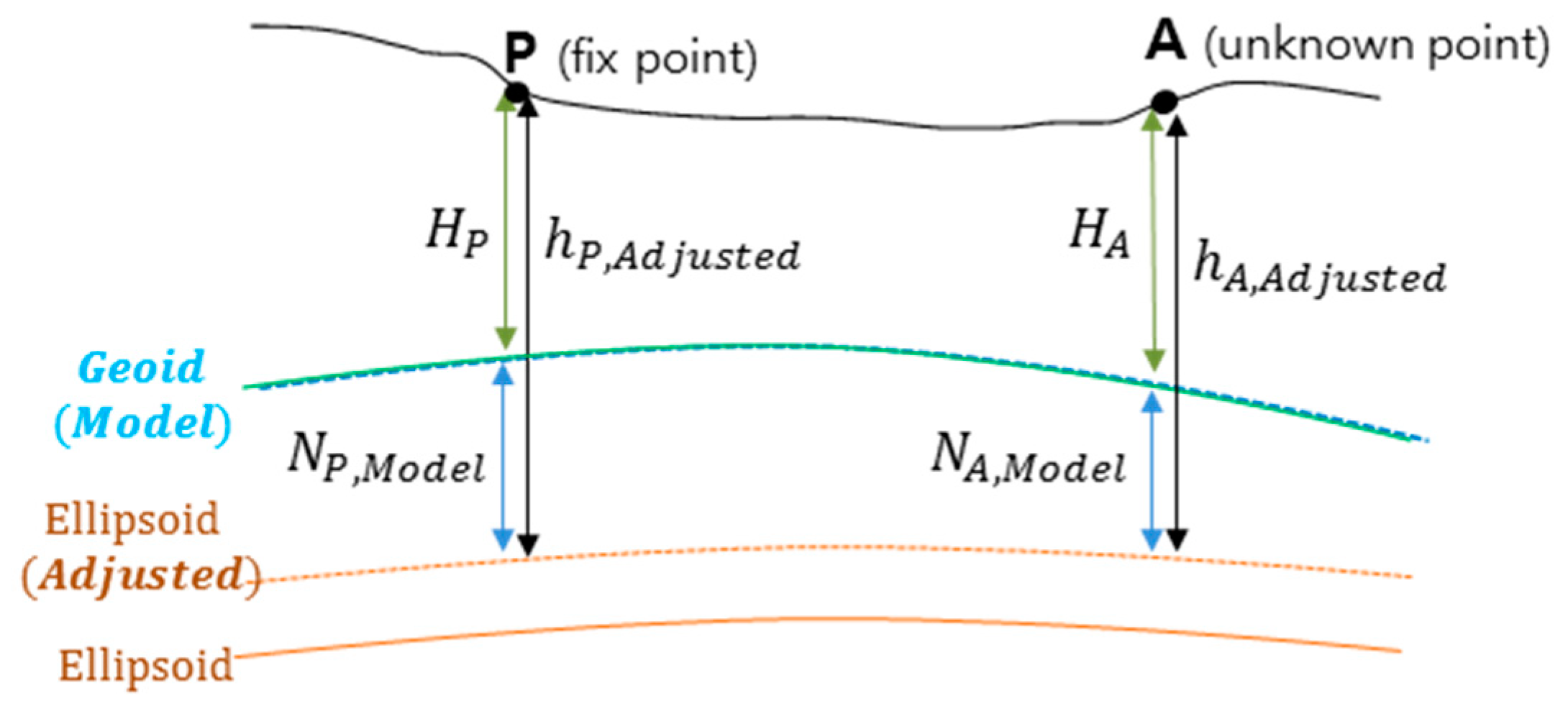
GNSS-derived height determination is a modern surveying technique that determines the elevation as the difference between the ellipsoidal height from GNSS surveying and the geoidal height from the local geoid model. For reference, the gravimetric geoid is determined by referring to the global mean sea level, so that the hybrid geoid, which is adjusted to be identical to the local vertical datum by fitting the gravimetric geoid to the local GNSS/Leveling data, is applied. However, the modeled geoid surface is not identical to the true geoid surface. Thus, the elevation, computed by directly subtracting the geoidal height from the ellipsoidal height determined by GNSS surveying, does not coincide with the elevation as determined by spirit leveling. Therefore, removing the bias between the geoid surfaces is key to determining the GNSS-derived elevation. However, it is impossible to determine the bias between these geoid surfaces. Thus, it is assumed that the geoid surface is the same, and the adjusted ellipsoidal height is calculated as the sum of the official elevation determined by leveling and geoidal height. This value is used instead of the ellipsoidal height from GNSS surveying to remove the bias.
A more detailed description of the procedure for determining GNSS-derived elevation is provided in
Figure 1. Here, P is a fixed station where the precise position and height (ellipsoidal height and elevation) are already known, and A is an unknown station. First, the adjusted ellipsoidal height at P is calculated as a sum of the elevation determined by leveling and geoidal height, as shown in the following equation.
where
and
are the adjusted ellipsoidal height and official elevation, respectively, for
P.
is the geoidal height calculated from the local geoid model at
P.
Second, the ellipsoidal height at A is determined via GNSS post-processing. As the adjusted ellipsoidal height is used at P, the adjusted ellipsoidal height is computed at A. During this processing, in principle, the latitude, longitude, and adjusted ellipsoidal height of the fixed station should be fixed. However, only the adjusted ellipsoidal height is fixed when the latitude and longitude are fixed at other fixed stations.
Finally, the elevation at
A is calculated by subtracting the geoidal height from the ellipsoidal height determined in step 2, following the equation below:
where
is the GNSS-derived elevation,
is the adjusted ellipsoidal height determined by GNSS processing, and
is the geoidal height calculated from the local geoid model at
A.
The guidelines for GNSS-derived height determination in Korea was introduced in 2014, following the above principle [
12,
13]. This approach assumes that the static differential GNSS surveying is conducted to obtain GNSS data. In detail, it is applicable when the target precision of the GNSS-derived elevation is 3 cm and 5 cm, respectively. The required observation duration differs according to the desired target precision. To obtain a target precision of 3 cm, it is necessary to survey for 4 h/day for two days. The observation time for each day should be set considering satellite geometry. Only 2 h of GNSS surveying is sufficient for a target precision of 5 cm, however. The logging time intervals shorter than 30 s and 15 s, respectively, is necessary.
To guarantee the stability of the geometric distribution, all unknown stations should be surrounded by at least three fixed stations. This is a common approach in countries applying the GNSS-derived height determination technique. However, it is not possible to apply this method in all scenarios. In the case of coastal regions or islands, control stations are not always located in the required locations, and there are fewer available stations than requirements. In addition, the official elevations of island stations might refer to a locally determined vertical datum. Therefore, if control stations referring to different vertical datum are discounted, it is common for unknown stations not to be surrounded by fixed stations. In Korea, therefore, the guidelines were updated by adding an exception for coastal regions or islands in 2017 [
14]. According to the guidelines, the elevations of unknown stations located in the coastal region or islands can be determined by fixing only two inland stations. At least two stations are required so as to maintain the stability of the network. Additionally, the maximum baseline distance between the control stations should be shorter than 20 km.
During processing, two cases of adjusted ellipsoidal height should be calculated, using half of the total observation time; they should then be compared to each other to check the consistency according to the time. The differences in the cases should be smaller than 3 cm or 5 cm, depending on the target precision. This means that the adjusted ellipsoidal height from 4 h of the first day, and on the second day, should be smaller than 3 cm.
The most recent model should be applied to the geoid model. In Korea, KNGeoid18, which has a 2.3 cm degree of fit (DOF), was developed [
15] so that it should be applied to GNSS-derived height determination. The detailed surveying conditions in Korea are summarized in
Table 1. For reference, the latest version of the guidelines was re-announced in January 2020 because the public surveying rules were amended by officially adopting GNSS-derived height determination in December 2019 [
16] and the development of KNGeoid18. However, the principles and conditions are identical to the previous guidelines, so the contents were not changed.
3. Precision Analysis of GNSS-Derived Elevations
3.1. Test Regions
Since the GNSS-derived height determination was introduced in 2014, only some studies have been performed in Korea [
17,
18,
19,
20]. Most of the test regions were located inland. Here, however, the aim was to analyze the precision of GNSS-derived elevation in the coastal regions and islands and verify the applicability of GNSS-derived height determination for unifying the inland and island areas. Therefore, the GNSS-derived elevation was determined by fixing two near control stations located inland, considering the actual surveying environment. The five test regions for this study are located in the western and southern parts of Korea, where there are many islands. The original GNSS data were obtained by National Geographic Information Institute (NGII) research projects [
21,
22,
23].
Figure 2 shows the geometric distribution of the fixed and unknown stations; the stations are also summarized in
Table 2. In the case of USS04B, USS13B, TBM1, and TBM2, which are located in regions one and five, the elevations were computed by both GNSS-derived height determination and sea-crossing leveling. The fixed or unknown stations with names starting with “U” are newly established 3D control points called unified control points (UCPs). These UCPs have official ellipsoidal heights and elevations. Stations ending with “B” are supplement points of UCPs. UCPs installed from 2008 to 2010 use names in the form of “U” + number, whereas those installed after 2011 use “U” + region name + number. Thus, USS04 is a UCP installed in the Seo-San (SS) region. 14-04-24-06 and 14-00-29-02 are the spirit benchmarks, and TBM is a temporarily installed point for sea-crossing leveling. Through the distribution illustrated in
Figure 2, it was found that the unknown stations were not surrounded; instead, only two fixed stations located inland were connected with unknown stations.
3.2. Precision Analysis
For the post-processing of GNSS data, commercial software is allowed in Korea. Thus, Leica Geo Office (LGO) version 8.2 was applied for the processing. The precision of the GNSS-derived elevation at each unknown station was evaluated through comparison with elevation determined by spirit leveling. In the case of regions three and four, the unknown stations were located on islands, and the official elevations given by NGII were computed by referring to the locally determined vertical datum. However, a bridge connecting inland and islands was recently constructed. Thus, the spirit leveling surveying was conducted again, and elevations were re-calculated by fixing them with nearby benchmarks or UCPs; these corrected elevations were applied in this study. The elevations of the unknown stations located in region three were calculated by adding leveling observations to the elevations of the fixed station, U1167. For the stations located in region four, U0531 and TBM were calculated by fixing them to the benchmark 37-25-00. Furthermore, UGN58 and TBM2 were calculated by fixing them to 12-00-30-12. For other unknown stations in regions one, two, and five, the elevations given by NGII were already determined by spirit leveling, so the official elevations were applied without any re-calculations. As all of the elevations of the unknown stations were determined based on spirit leveling (including the re-calculations in regions three and four), the reference elevations are referred to herein as leveling-based elevations regarding precision analysis. As mentioned before, regardless of whether the official values given by NGII or the re-calculated ones were applied, all elevations applied to references values mean normal orthometric heights because real gravity values were not considered.
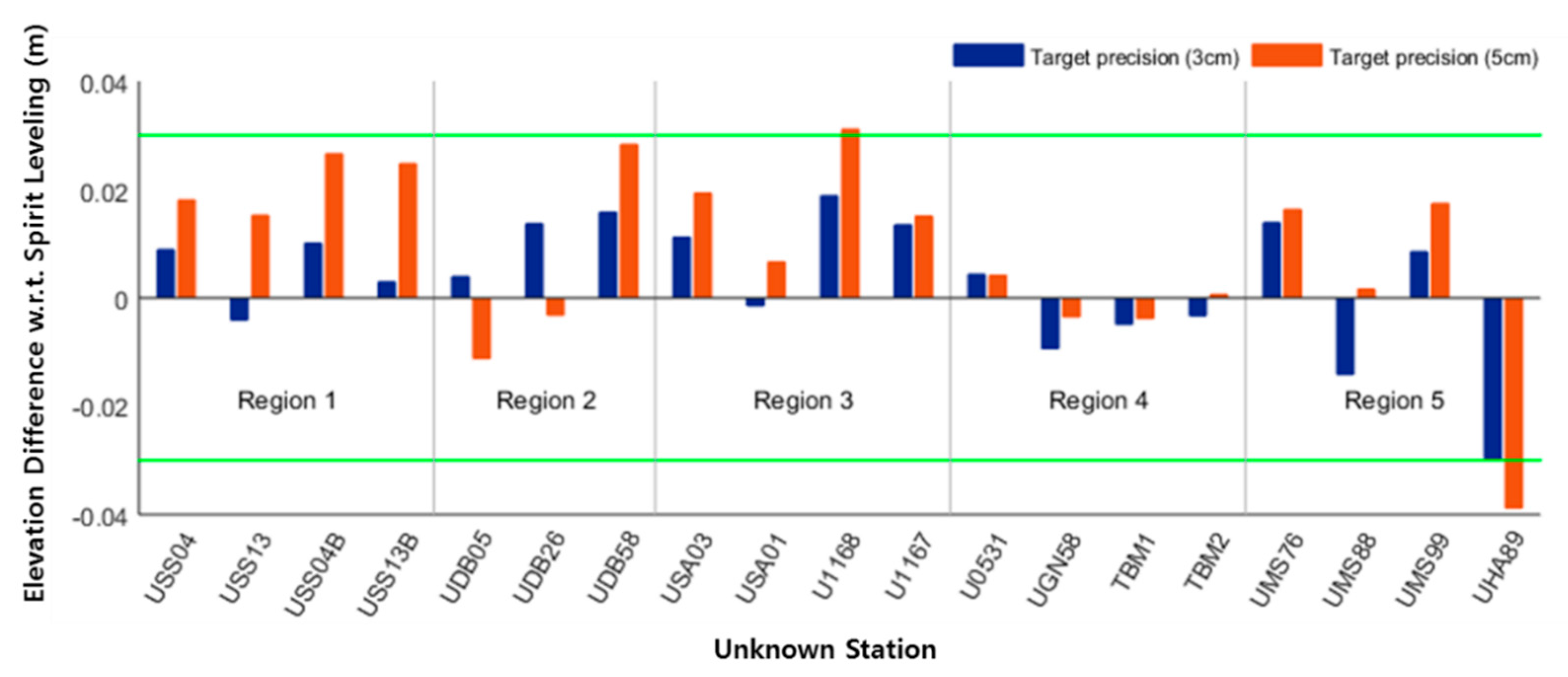
Figure 3 and
Table 3 show the differences between GNSS-derived elevations and those obtained from spirit leveling for the 19 unknown stations located in the five test regions for target precisions of 3 and 5 cm. As shown in
Figure 3 and
Table 3, all GNSS-derived elevations showed differences smaller than 3 cm compared to spirit leveling-based elevations (when GNSS surveying was conducted for 4 h/day for two days). The difference was smaller than 1 cm at ten stations (52.63%), and was smaller than 2 cm at eighteen stations (94.73%). Thus, the mean absolute difference was calculated to be approximately 1 cm. The maximum difference (2.79 cm) was found at Station UHA89, located in region five. Even this did not exceed the target precision of 3 cm, however. Considering that UHA89 had a relatively long baseline compared to the other unknown stations, the GNSS-derived elevation can be said to have sufficiently met the target precision when fixing only two control stations in coastal or island areas.
GNSS-derived elevations computed based on two hours of GNSS data revealed that seven stations (36.84%) showed a difference of less than 1 cm compared to the elevations from spirit leveling. Fourteen (73.68%) and seventeen (89.47%) stations exhibited differences smaller than 2 and 3 cm, respectively. The mean absolute difference was calculated to be approximately 1.5 cm, meaning that elevations with 5 cm precision could be determined based on GNSS and the local geoid model. The maximum difference (3.88 cm) occurred at station UHA89, which also exhibited the largest difference under the 3 cm target precision. As mentioned above, this maximum difference likely occurred due to the station’s long baseline. Other stations in region five (UMS76, UMS88, and UMS99) use a different region name to UHA89, indicating that they are located in a different region. Thus, the incomplete removal of local bias from the geoid model may also have led to this larger discrepancy. Despite the relatively large difference, however, it still did not exceed the target precision of 5 cm.
It was found that elevations with precisions smaller than 3 cm or 5 cm could be determined through GNSS-derived height determination, despite being fixed to only two inland stations. Of course, well-conducted GNSS surveying and precise geoid model were mainly used to complement the weaknesses of traditional geometry. In addition, the gentle changes in topography in coastal areas and islands could also have helped to contribute to the observed stability. For reference, the unknown stations in this study are located in the coastal area or islands, so variations in the terrain are quite small. Most elevations of unknown points were smaller than 50 m and the maximum did not exceed 100 m; thus, the geoidal heights in the same test region changed within a 30 cm level. Thus, it is expected that precision will be improved in scenarios where unknown stations are surrounded by fixed stations, for example, during inland surveying.
3.3. Possibility of Substituting GNSS-Derived Height Determination for Sea-Crossing Leveling
GNSS-derived height determination is a useful surveying technique to connect islands, which refers to a local vertical datum, to inland unified vertical datum. The unification of various vertical datums is required in the field of surveying or construction, for example, when constructing bridges, to ensure safety. Furthermore, GNSS-derived height determination is meaningful because it could help to realize global unified vertical datum, which would be especially useful for monitoring, warning, and restoration of disasters across countries [
24,
25,
26]. Before the introduction of GNSS and the construction of the precision geoid model, the elevations of stations located in islands were determined by sea-crossing leveling. The details of the surveying techniques and instruments used differ depending on the observation distance between the control and unknown stations, but the principle remains unchanged: both the distance and angle are measured and then converted to vertical elevation. When the leveling network is disconnected due to rivers or seas, the distance between the control and unknown stations generally exceeds a few kilometers. Thus, surveying instruments are set to both sides where the control and unknown stations are located and observations are collected at the same time to minimize errors (i.e., collimation and atmospheric refraction errors). In addition, the required number of observation repetitions increases as the distance between stations increases. For reference, Korean surveying guidelines state that observations should be performed for three days with a total of 280 repetitions at a distance of 3 km [
27].
In this study, sea-crossing leveling was conducted in two regions to check the possibility of substituting GNSS-derived height determination for sea-cross leveling. USS04B–USS13B, located in region one, and TBM1–TBM2, located in region four, were the selected surveying sections. The distances for both sections are approximately 3.33 km. In the case of USS04B–USS13B, sea-crossing leveling was conducted following Korean surveying guidelines; 280 repetitions (140 repetitions per side) of observation data were collected for seven days in 2016 [
21]. When analyzing the dataset, it was found that 80 repetitions per side were sufficient to determine the elevation difference of the section [
21]. Thus, for section TBM1–TBM2, 120 repetitions per side were observed for six days. The final elevation differences of each section were then determined by averaging all observations [
23].
Table 4 shows the elevation differences determined by sea-crossing leveling, GNSS-derived height determination, and spirit leveling. In the case of GNSS-derived height determination and spirit leveling, the elevation differences were computed based on the elevation of each station. The GNSS-derived elevation in each case refers to the elevation obtained from the 3 cm target precision. The elevation difference for section USS04B–USS13B was determined to be 0.3156 m; differences of 0.3201 and 0.3084 m were calculated for sea-crossing leveling and GNSS-derived height determination, respectively. Compared to the elevation difference calculated from spirit leveling, both surveying techniques showed a difference of less than 1 cm. When surveying is performed again, the elevation difference between stations should not exceed 15 mm
(where
S is the distance in km) according to the Korean surveying guidelines [
27]. This means that the results from sea-crossing leveling and GNSS-derived height determination should coincide with a level of approximately 2.7 cm; in both cases, these techniques met this limit. In the case of section TBM1–TBM2, the sea-crossing leveling and GNSS-derived elevations were both smaller than the above limit. However, GNSS-derived elevation did not exceed the limit of surveying and showed better consistency than sea-crossing at the approximately 1 cm level. This differed from that of spirit leveling, unlike section USS04B–USS13B, where the two were similar. The comparison results of the elevation differences at these two sections among the surveying methods are summarized in
Table 4.
In terms of surveying time, there is a large difference between the sea-crossing leveling and GNSS-derived height determinations. For both sections, two days of GNSS surveying were conducted for the GNSS-derived height determination. On the other hand, seven and six days were spent on sea-crossing leveling for sections USS04B–USS13B and TBM1–TBM2, respectively. Although fewer repetitions were conducted for section TBM1–TBM2, sea fog caused huge inconsistencies in the observations. Thus, re-surveying was conducted, so one day’s worth of observations was lost. These kinds of environmental effects frequently occur during sea-crossing leveling, which uses optical instruments. These environmental effects can cancel surveying. GNSS-derived height determination, however, is largely unaffected by environmental effects. Therefore, it would be a more efficient way to determine the elevations of stations located in the region that refer to local vertical datum, considering its effectiveness, shorter surveying time, and similar level of precision. However, the precision of the local geoid model represents a risk factor in this regard. The local geoid model was developed by adjusting the gravimetric geoid to the GNSS/Leveling data that are generally located inland. Therefore, the precision is relatively high inland, but it could decreas in offshore areas. It is, thus, necessary to continuously improve the precision of the geoid model over coastal and island areas to enable more generalized usage of GNSS-derived elevation in the field of surveying.
4. Conclusions
In this study, the applicability of GNSS-derived height determination for positioning objects located on islands or coastal areas was verified by comparing the GNSS-derived elevations of 19 unknown stations to elevations obtained from spirit leveling. In particular, the basic condition that unknown points should be surrounded by at least three control points in the GNSS-derived height determination could not be easily fulfilled in this coastal and island setting, so the stability obtained when fixing only two fixed points was checked.
When GNSS-derived elevations on 19 unknown points were determined based on surveying for 4 h/day for two days, all points showed differences smaller than 3 cm compared to the spirit leveling results. Though the maximum difference was 2.97 cm, 18 stations (94.73%) had differences smaller than 2 cm. Thus, the target precision of 3 cm is expected to be fully achievable. When GNSS surveying was conducted for the GNSS-derived height determination, all unknown points met the target precision of 5 cm, and the maximum difference was calculated to be 3.88 cm. Fourteen (73.68%) and 17 (89.47%) stations showed differences of less than 2 cm and 3 cm, respectively. As shown in the test results, the target precision in GNSS-derived height determination was efficiently met by fixing only two control points. Thus, GNSS-derived elevation can be broadly applied in the surveying field.
GNSS-derived height determination is an efficient way to connect different vertical datums between inland and island areas, and replace the traditional method of sea-crossing leveling. Here, the possibility of replacing sea-crossing leveling with GNSS-derived height determination was checked in terms of precision and time effectiveness. When applied to two test sections, both surveying methods showed differences smaller than 2.7 cm compared to spirit leveling (this limit was calculated based on surveying guidelines). Furthermore, for one of these sections, the GNSS-derived height determination showed a much smaller difference. The surveying time for GNSS-derived height determination is also shorter than that required for sea-crossing, and the former method also avoids the issue of environmental influences, such as sea fog. However, it should be mentioned that the geoid model should be further improved regarding its relatively low precision in coastal and island areas.


