
Present Tectonic Dynamics of the Geological Structural Setting of the Eastern Part of the Adriatic Region Obtained from Geodetic and Geological Data


Abstract
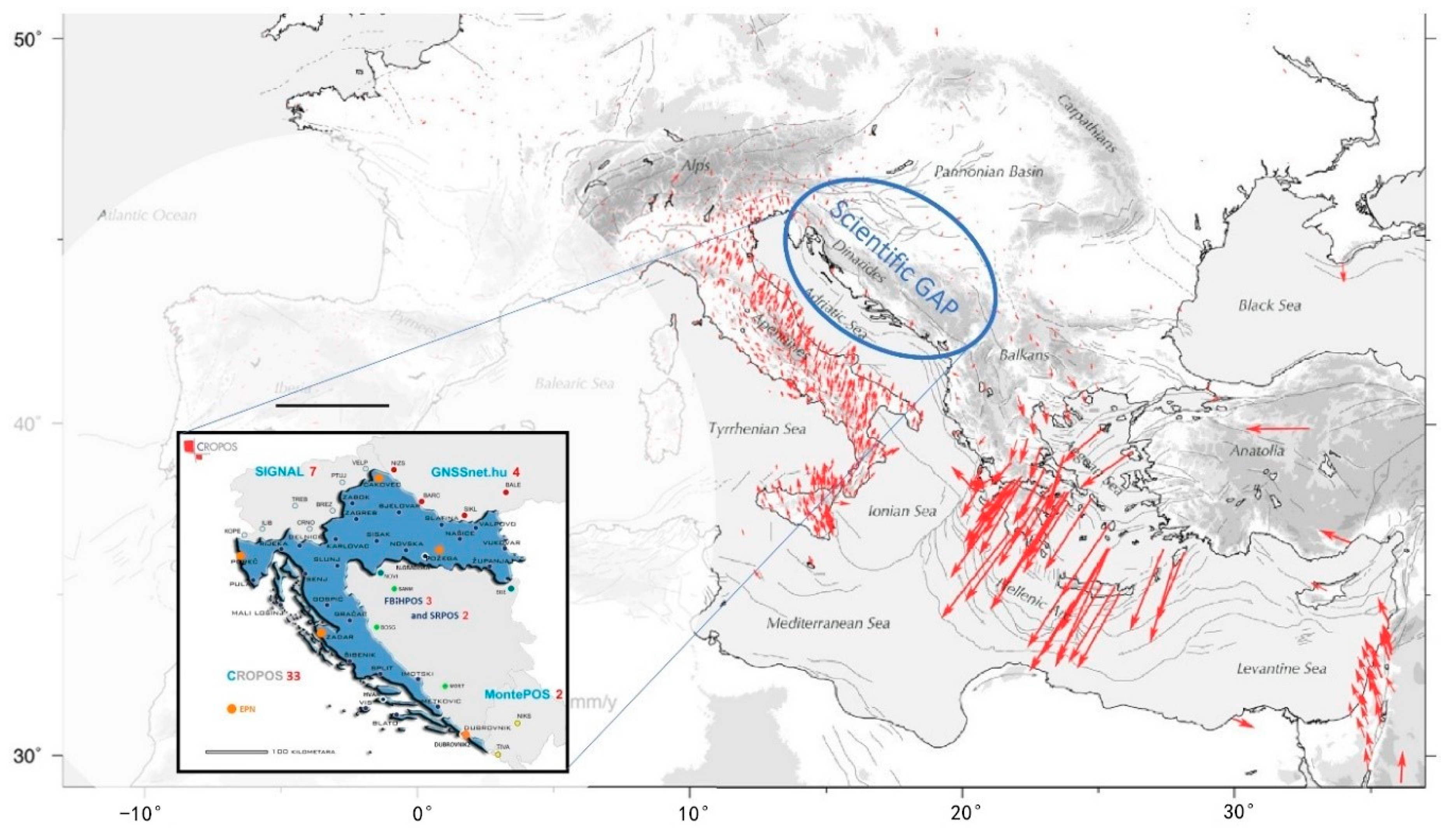
:1. Introduction
2. Geodetic Surveys and Data Processing
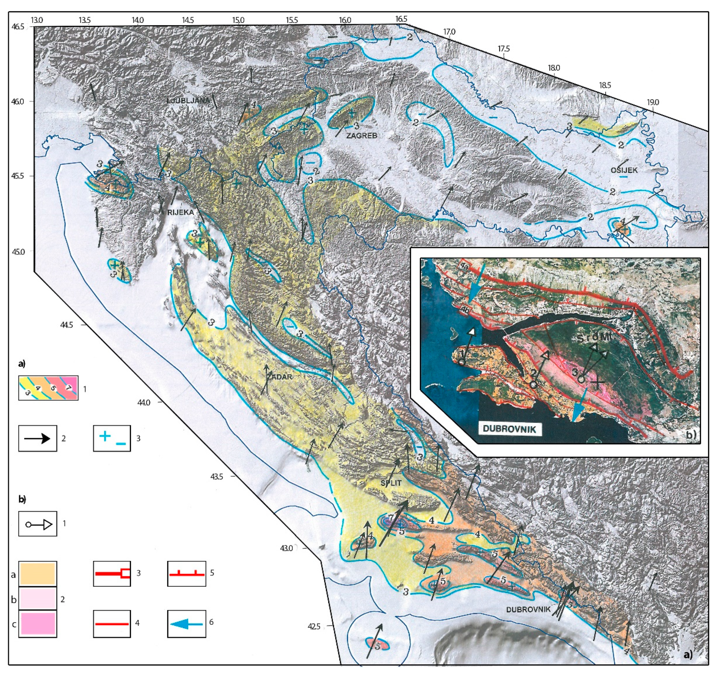
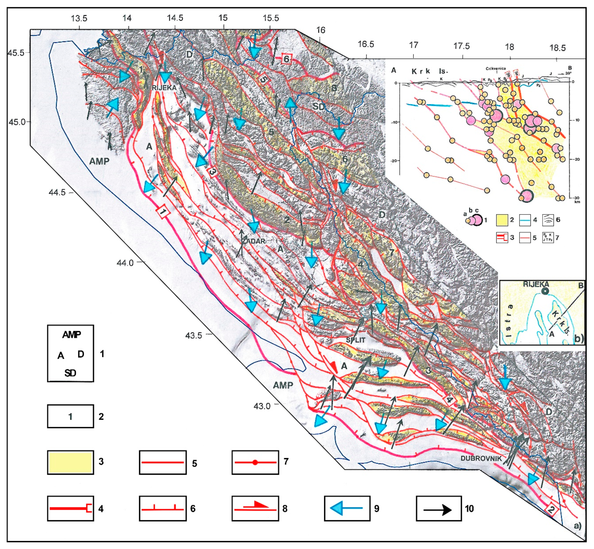
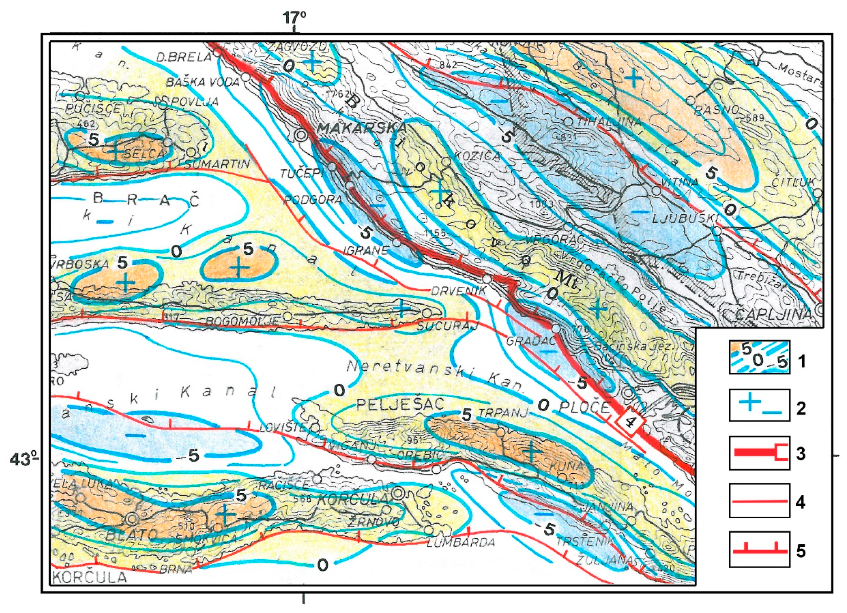
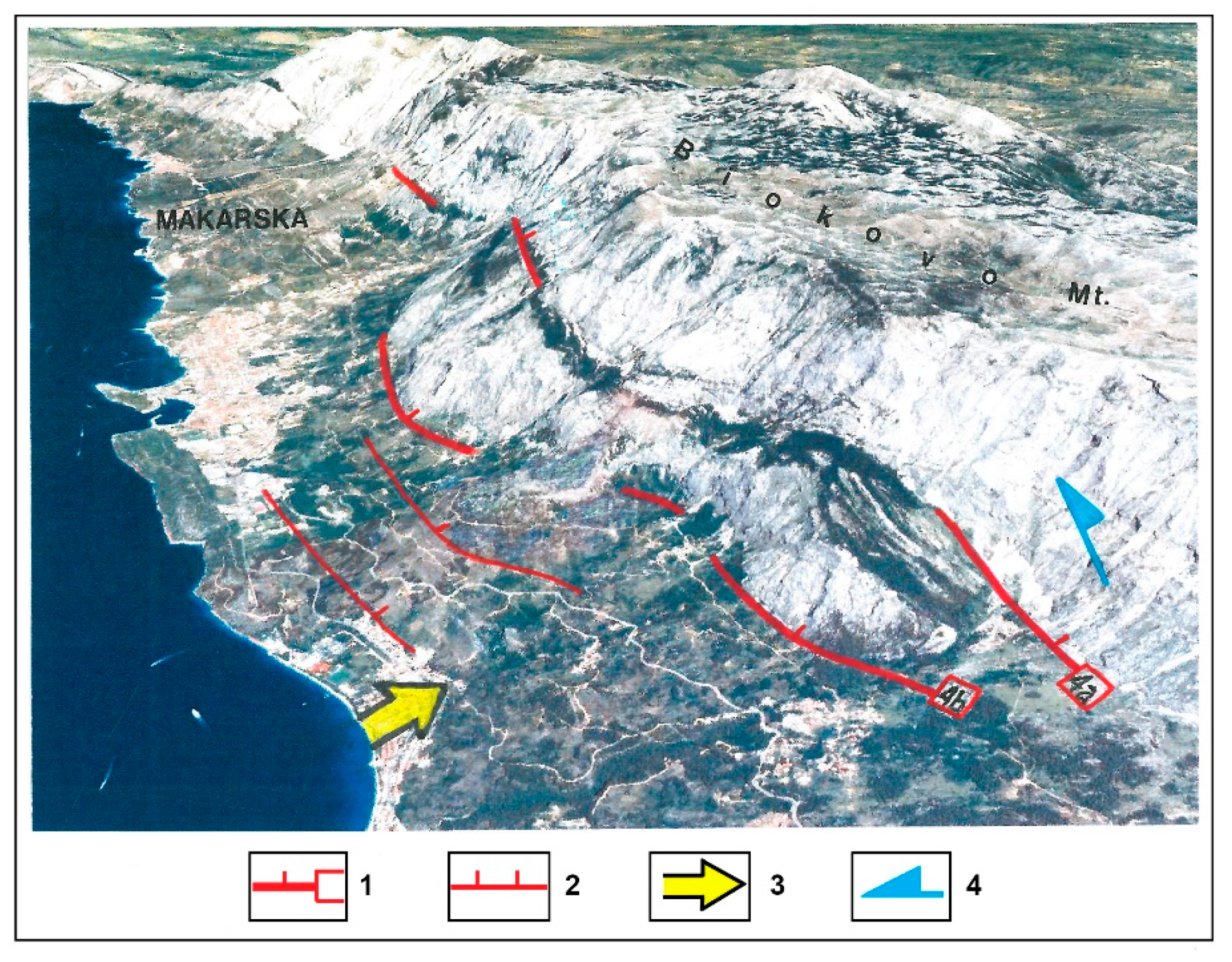
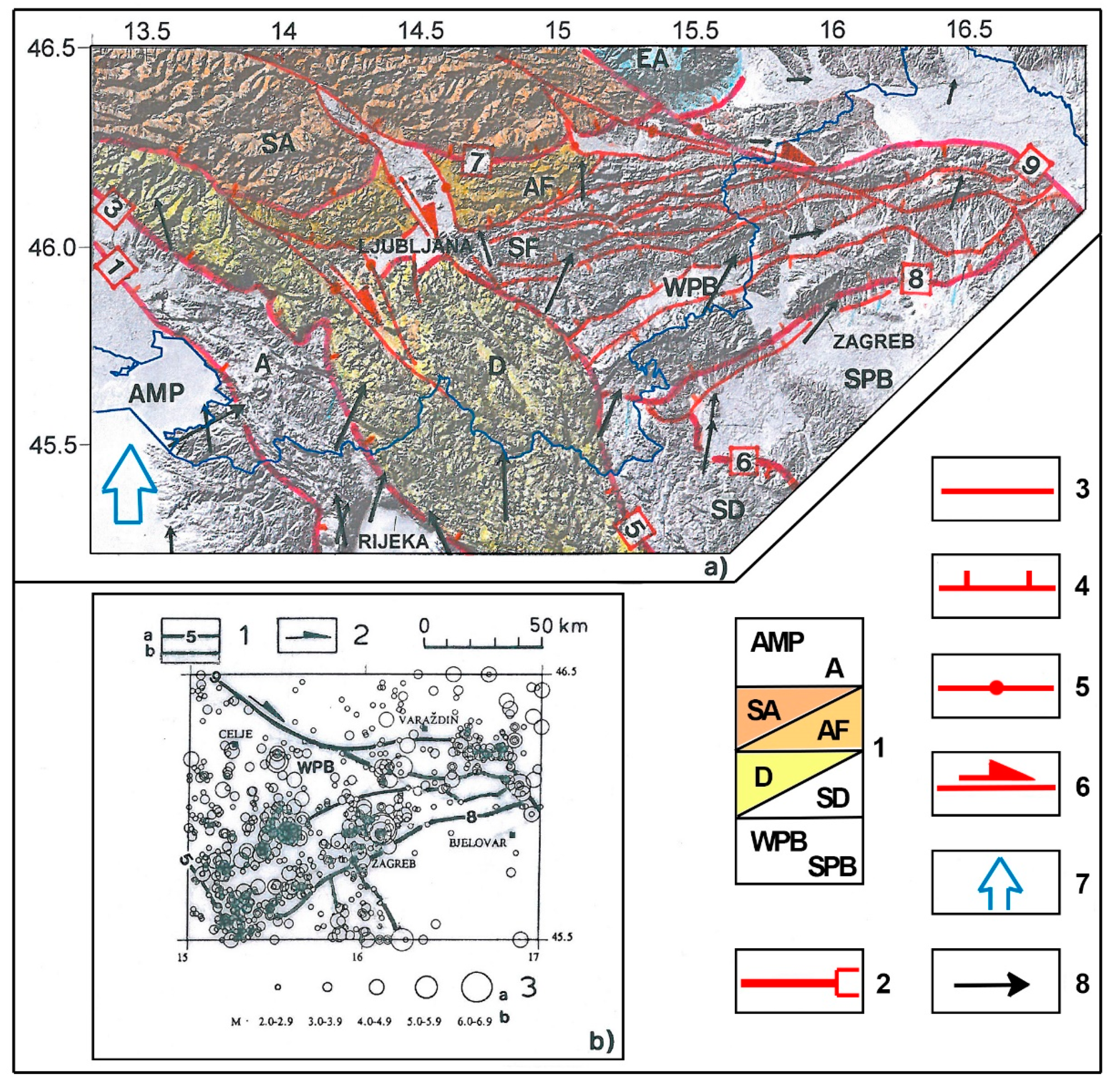
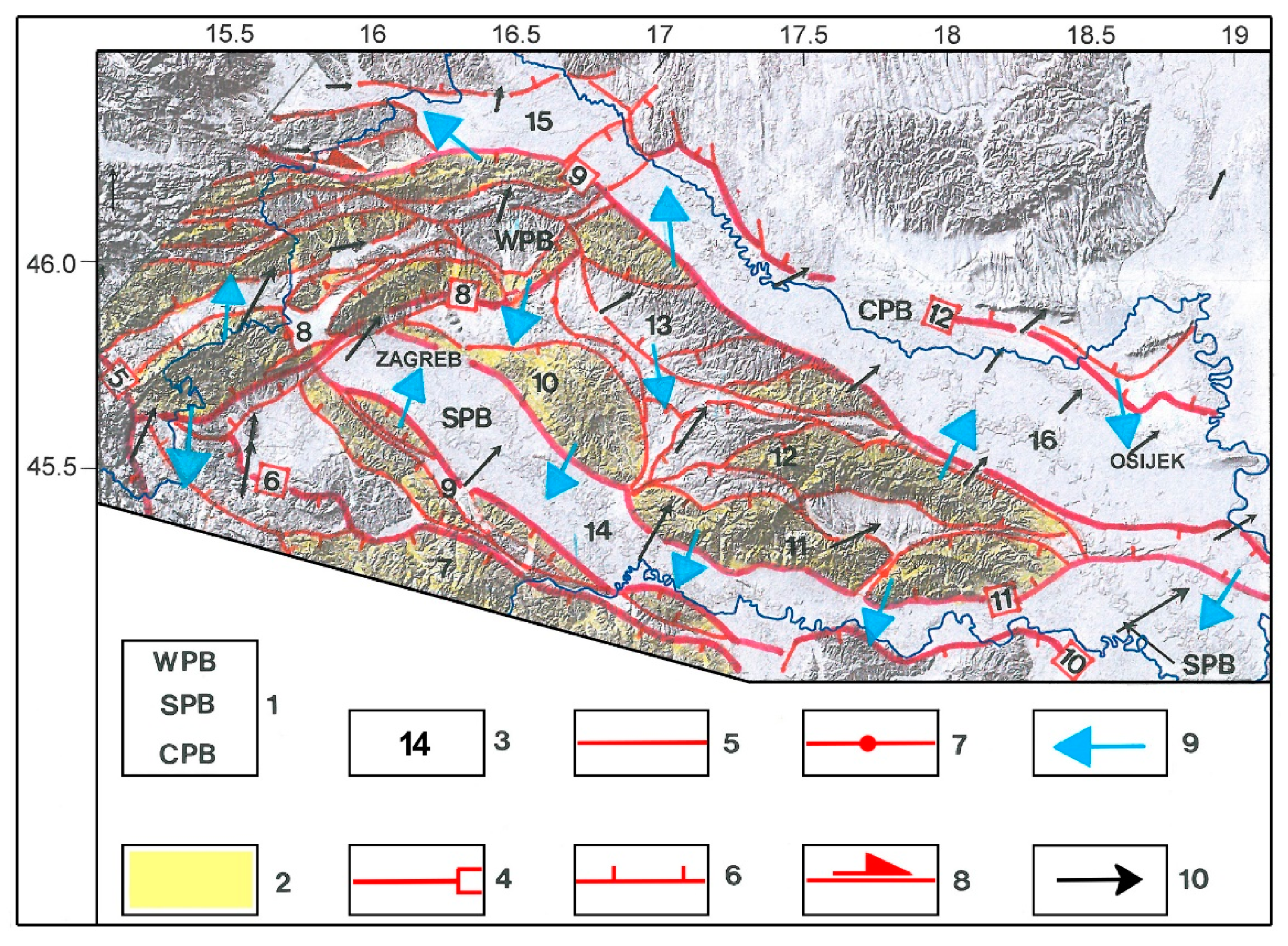
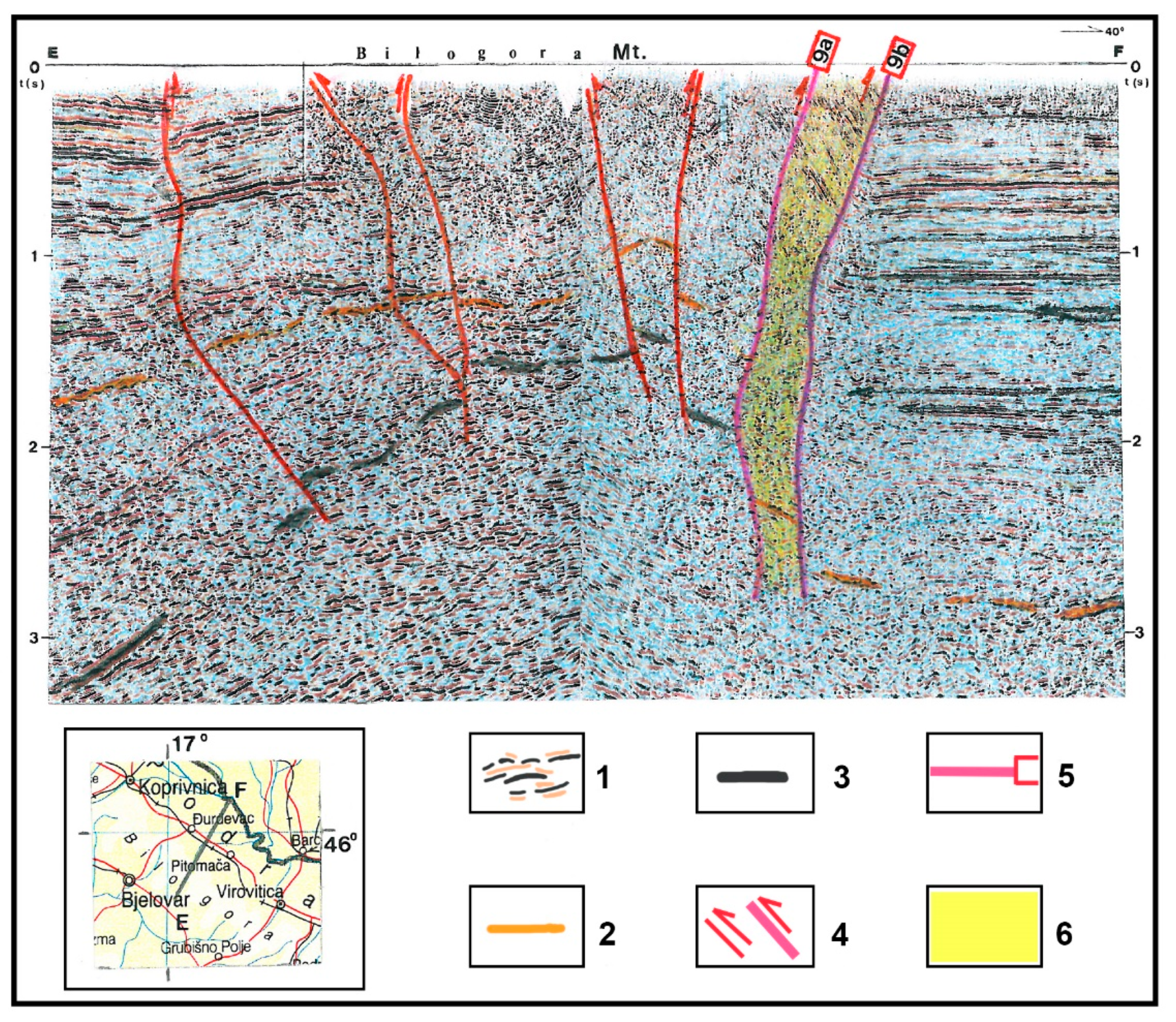
3. Geological Data Interpretation
4. Results and Discussion: Recent Geological Structure Setting, Causes of Tectonic Activity, and Structure Movements
5. Conclusions
Author Contributions
Funding
Acknowledgments
Conflicts of Interest
References
- Caporali, A.; Aichhorn, C.; Barlik, M.; Becker, M.; Fejes, I.; Gerhatova, L.; Ghitau, D.; Grenerczy, G.; Hefty, J.; Krauss, S.; et al. Surface kinematics in the Alpine–Carpathian–Dinaric and Balkan region inferred from a new multi-network GPS combination solution. Tectonophysics 2009, 474, 295–321. [Google Scholar] [CrossRef]
- D’Agostino, N.; Avallone, A.; Cheloni, D.; D’Anastasio, E.; Mantenuto, S.; Selvaggi, G. Active tectonics of the Adriatic region from GPS and earthquake slip vectors. J. Geophys. Res. Space Phys. 2008, 113, 113. [Google Scholar] [CrossRef]
- Devoti, R.; D’Agostino, N.; Serpelloni, E.; Pietrantonio, G.; Riguzzi, F.; Avallone, A.; Cavaliere, A.; Cheloni, D.; Cecere, G.; D’Ambrosio, C.; et al. A Combined Velocity Field of the Mediterranean Region. Ann. Geophys. 2017, 60, 215. [Google Scholar] [CrossRef] [Green Version]
- Dach, R.; Hugentobler, U.; Fridez, P.; Meindl, M. (Eds.) Bernese GPS Software Version 5.0. User Manual; Astronomical Institute, University of Bern: Bern, Switzerland, 2007; Available online: ftp://ftp.space.dtu.dk/pub/fch/bernese/DOCU50.pdf (accessed on 20 December 2020).
- Aljinović, B.; Cvijanović, D.; Labaš, V.; Prelogović, E.; Skoko, D. Geološka građa područja Dubrovnika na temelju seizmotektonskih i geofizičkih istraživanja. In X. Kong. Geol. Jug.; Zavod za geološka istraživanja: Budva, Montenegro, 1982; pp. 527–539. [Google Scholar]
- Anderson, H.; Jackson, J. Active tectonics of the Adriatic Region. Geophys. J. Int. 1987, 91, 937–983. [Google Scholar] [CrossRef]
- Skoko, D.; Prelogović, E.; Aljinović, B. Geological structure of the Earth’s crust above the Moho discontinuity in Yugoslavia. Geophys. J. Int. 1987, 89, 379–382. [Google Scholar] [CrossRef] [Green Version]
- Herak, M. Dinarides-Mobilistic view of the genesis and structures. Acta Geol. 1991, 21, 35–117. [Google Scholar]
- Pamić, J.; Gušić, I.; Jelaska, V. Geodynamic evolution of the central Dinarides. Tectonophysics 1998, 297, 251–268. [Google Scholar] [CrossRef]
- Prelogovic, E.; Aljinovic, B.; Bahun, S. New data on structural relationships in the north Dalmatian Dinaride area. Geol. Croat. 1995, 48, 167–176. [Google Scholar] [CrossRef]
- Prelogović, E.; Velić, J.; Saftić, B. Structural dynamics of the southern part of Pannonian Basin in Croatia. Am. Assoc. Pet. Geol. Bull. 1997, 81. [Google Scholar] [CrossRef]
- Prelogović, E.; Kuk, V.; Buljan, R. The structural fabric and seismotectonic activity of northern Velebit: Some new observations. Rud. Geol. Naft. Zb. 1998, 10, 39. [Google Scholar]
- Prelogović, E.; Pribičević, B.; Dragičević, I. Recentni Strukturni Sklop Dinarida (Recent Structural Setting of the Dinarides); Faculty of Mining, Geology and Petroleum Engineering, University of Zagreb: Zagreb, Croatia, 2001. [Google Scholar]
- Prelogović, E.; Pribičević, B.; Dragičević, I.; Buljan, R.; Kapelj, J. Tektonska Aktivnost i Klasifikacija Struktura Pogodnih za Naftno Geološka Istraživanja u Prostoru Centralnog Jadrana i Dinarida; Faculty of Mining, Geology and Petroleum Engineering, University of Zagreb: Zagreb, Croatia, 2003. [Google Scholar]
- Prelogović, E.; Pribičević, B.; Ivković, Ž.; Dragičević, I.; Buljan, R.; Tomljenović, B. Recent structural fabric of the Dinarides and tectonically active zones important for petroleum-geological exploration in Croatia. Naft. Explor. Prod. Process. Petrochem. 2004, 55, 155–161. [Google Scholar]
- Tari, V.; Pamić, J. Geodynamic evolution of the northern Dinarides and the southern part of the Pannonian Basin. Tectonophysics 1998, 297, 269–281. [Google Scholar] [CrossRef]
- Lučić, D.; Saftić, B.; Krizmanić, K.; Prelogović, E.; Britvić, V.; Mesić, I.; Tadej, J. The neogene evolution and hydrocarbon potential of the pannonian basin in croatia. Mar. Pet. Geol. 2001, 18, 133–147. [Google Scholar] [CrossRef]
- Tomljenović, B.; Csontos, L. Neogene-quaternary structures in the border zone between Alps, Dinarides and Pannonian Basin (Hrvatsko zgorje and Karlovac basins, Croatia). Int. J. Earth Sci. 2001, 90, 560–578. [Google Scholar] [CrossRef]
- Vrabec, M.; Fodor, L. Late Cenozoic Tectonics of Slovenia: Structural Styles at the Northeastern Corner of the Adriatic Microplate. In The Adria Microplate: GPS Geodesy, Tectonics and Hazards; Kluwer Academic Publishers: Dordrecht, The Netherlands, 2006; pp. 151–168. [Google Scholar] [CrossRef]
- Shebalin, N.V.; Karnik, V.; Hadzievski, D. (Eds.) Catalogue of earthquakes of the balkan region. In UNDP-UNESCO Survey of the Seismicity of the Balkan Region; UNESCO: Skopje, Macedonia, 1974; Available online: https://www.emidius.eu/AHEAD/study/SHAL974 (accessed on 12 January 2021).
- Herak, M.; Herak, D.; Markušić, S. Karta seizmičke aktivnosti Hrvatske; Geofizički Zavod: Zagreb, Croatia, 2008. [Google Scholar]
- Herak, M.; Herak, D.; Markušić, S. Revision of the earthquake catalogue and seismicity of Croatia, 1908–1992. Terra Nova 1996, 8, 86–94. [Google Scholar] [CrossRef]
- Markušić, S.; Gulerce, Z.; Kuka, N.; Duni, L.; Ivančić, I.; Radovanović, S.; Glavatović, B.; Milutinović, Z.; Akkar, S.; Kovačević, S.; et al. An updated and unified earthquake catalogue for the Western Balkan Region. Bull. Earthq. Eng. 2016, 14, 321–343. [Google Scholar] [CrossRef]
- Cvijanović, D.; Prelogović, E.; Kranjec, V.; Skoko, D.; Zagorac, Ž.; Bahun, S.; Oluić, M. Seizmotektonska Karta Hrvatske i Susjednih Područja; Geofizički Zavod: Zagreb, Croatia, 1979. [Google Scholar]
- Dragicevic, I.; Prelogovic, E.; Kuk, V.; Buljan, R. Recent Tectonic Activity in the Imotsko Polje Area. Geol. Croat. 1999, 52. [Google Scholar] [CrossRef]
- Kuk, V.; Prelogović, E.; Dragičević, I. Seismotectonically Active Zones in the Dinarides. Geol. Croat. 2000, 53, 295–303. [Google Scholar] [CrossRef]
- Ivančić, I.; Herak, D.; Herak, M.; Allegretti, I.; Fiket, T.; Kuk, K.; Markušić, S.; Prevolnik, S.; Sović, I.; Dasović, I.; et al. Seismicity of Croatia in the period 2006–2015. Geofizika 2018, 35, 69–98. [Google Scholar] [CrossRef]
- Altiner, Y. Analytical Surface Deformation Theory; Springer: Berlin/Heidelberg, Germany, 1999. [Google Scholar]
- Altiner, Y.; Marjanović, M.; Medved, M.; Rasić, L. Active Deformation of the Northern Adriatic Region: Results from the CRODYN Geodynamical Experiment; Springer: Dordrecht, The Netherlands, 2006; pp. 257–267. [Google Scholar]
- Altiner, Y.; Cigrovski-Detelić, B.; Čolić, K.; Seeger, H. Present crustal deformations in the Adriatic Sea area on the basis of GPS-observations. In Proceedings of the Second International Symposium “Geodynamics of the Alps-Adria Area by Means of Terrestrial and Satellite Methods”, Dubrovnik, Croatia, 28 September–2 October 1998; pp. 37–48. [Google Scholar]
- Oldow, J.S.; Ferranti, L.; Lewis, D.S.; Campbell, J.K.; D’Argenio, B.; Catalano, R.; Pappone, G.; Carmignani, L.; Conti, P.; Aiken, C.L.V. Active fragmentation of Adria, the north African promontory, central Mediterranean orogen. Geology 2002, 30, 779–782. [Google Scholar] [CrossRef]
- Medak, D.; Pribičević, B.; Prelogović, E. Determination of the recent structural fabric in the Alps-Dinarides area by combination of geodetic and geologic methods. In Raziskave s Področja Geodezije in Geofizike; Kuhar, M., Brilly, M., Eds.; Fakulteta za Gradbeništvo in Geodezijo, Univerza v Ljubljani: Ljubljana, Slovenia, 2002; pp. 57–64. [Google Scholar]
- Medak, D.; Pribičević, B. Processing of Geodynamic GPS networks in Croatia with GAMIT Software. In The Adria Microplate: GPS Geodesy, Tectonics and Hazards; Kluwer Academic Publishers: Dordrecht, The Netherlands, 2006; pp. 247–256. [Google Scholar] [CrossRef]
- Mantovani, E.; Babbucci, D.; Viti, M.; Albarello, D.; Mugnaioli, E.; Cenni, N.; Casula, G. Post-Late Miocene Kinematics of the Adria Microplate: Inferences From Geological, Geophysical and Geodetic Data. In The Adria Microplate: GPS Geodesy, Tectonics and Hazards; Kluwer Academic Publishers: Dordrecht, The Netherlands, 2006; pp. 51–69. [Google Scholar] [CrossRef]
- Pribičević, B.; Medak, D.; Prelogović, E. Investigation of geodynamics of Adria microplate by means of geodetic, geophysical and geologic methods. Rep. Geod. 2003, 64, 85–92. [Google Scholar]
- Pribičević, B.; Medak, D.; Prelogović, E. Geodetic and geologic research of recent tectonic activity in Dinarides. Rep. Geod. 2004, 69, 125–131. [Google Scholar]
- Pinter, N.; Gyula, G.; Weber, J.; Stein, S.; Medak, D. (Eds.) The Adria Microplate: GPS Geodesy, Tectonics and Hazards; Springer: Dordrecht, The Netherlands, 2006; Volume 61. [Google Scholar] [CrossRef]
- Grenerczy, G.; Kenyeres, A. Crustal Deformation Between Adria and the European Platform from Space Geodesy. In The Adria Microplate: GPS Geodesy, Tectonics and Hazards; Kluwer Academic Publishers: Dordrecht, The Netherlands, 2006; pp. 321–334. [Google Scholar] [CrossRef]
- Devoti, R.; Petrantonino, G.; Riguzzi, F. GNSS networks for geodynamics in Italy. Física La Tierra 2014, 26. [Google Scholar] [CrossRef] [Green Version]
- Solarić, M.; Bilajbegović, A.; Junašević, M.; Ambroš, F.; Cigrovski-Detelić, B.; Džapo, M.; Ivković, M.; Hećimović, Ž.; Barković, Đ.; Bačić, Ž.; et al. Pregled ostvarenih rezultata na znanstvenom projektu “Osnovni geodetski radovi informacijskoga prostornog sustava Republike Hrvatske” (Review of realized results in the researching and scientific project Fundamental geodetic works on the information spa. Geod. List 1996, 50, 29–49. [Google Scholar]
- Čolić, K.; Bašić, T.; Seeger, H.; Gojčeta, B.; Altiner, Y.; Rašić, L.; Medić, Z.; Pribičević, B.; Medak, D.; Marjanović, M.; et al. Hrvatska u EUREF’94 i projekt CRODYN (Croatia in EUREF’94 and the project CRODYN). Geod. List 1996, 50, 331–351. [Google Scholar]
- Altiner, Y.; Čolić, K.; Gojčeta, B.; Habrich, H.; Lipej, B.; Neumaier, P.; Marjanović, M.; Medić, Z.; Mišković, D.; Rašić, L.; et al. Results of a Re-computation of the EUREF GPS Campaigns in Croatia and Slovenia. In Proceedings of the Second International Symposium: Geodynamics of Alps-Adria Area by means of Terrestrial and Satellite Methods, Dubrovnik, Croatia, 28 September–2 October 1998; pp. 293–306. [Google Scholar]
- Marjanović, M.; Bačić, Ž. Computation of Combined Solution of EUREF GPS Campaigns 1994–1996 in Republic of Croatia; Verlag des Bundesamtes für Kartographie und Geodäsie: Frankfurt am Main, Germany, 2002. [Google Scholar]
- Marjanović, M.; Bačić, Ž.; Bašić, T. CROREF-05 GPS campaign-preliminary results. In Proceedings of the Symposium of the IAG Sub Commission for Europe (EUREF), Dubrovnik, Croatia, 16–18 May 2001; Mitteilungen des Bundesamtes für Kartographie und Geodäsie, EUREF Publication No 16. 2006; pp. 216–220. Available online: https://www.researchgate.net/publication/266615886_CROREF-05_GPS_campaign_-preliminary_results?channel=doi&linkId=543569c80cf2bf1f1f2abbcb&showFulltext=true (accessed on 8 December 2020).
- Čolić, K.; Bašić, T.; Seeger, H.; Gojčeta, B.; Altiner, Y.; Rašić, L.; Medić, Z.; Pribičević, B.; Medak, D.; Marjanović, M.; et al. Hrvatska u EUREF’94 i projekt CRODYN. Geod. List. Glas. Hrvat. Geod. Društva 1996, 50, 331–351. [Google Scholar]
- Ineichen, D.; Gurtner, W.; Springer, T.; Engelhardt, G.; Luthardt, J.; Ihde, J. EUVN97-Combined GPS Solution. Presented at the EUREF-Symposium, Bad Neuenahr-Ahrweiler, Germany, 3–5 June 1998; Mitteilungen des Bundesamtesfür Kartographie und Geodäsie, Band 7. 1999; pp. 23–46. Available online: https://evrs.bkg.bund.de/SharedDocs/Downloads/EVRS/EN/Publications/EUVN97CombinedGPSSolution.pdf?__blob=publicationFile&v=1 (accessed on 12 December 2020).
- Pavasović, M. CROPOS kao Hrvatski Terestrički Referentni Okvir i Njegova Primjena u Geodinamičkim Istraživanjima (CROPOS as Croatian Terrestrial Reference Frame and Its Application in Geodynamic Researches); University of Zagreb, Faculty of Geodesy: Zagreb, Croatia, 2014. [Google Scholar]
- Pesec, P. A multipurpose and interdisciplinary sensor array for environmental research in central Europe. Rep. Geod. 2002, 61, 20–28. [Google Scholar]
- Fejes, I. Consortium for central european GPS geodynamic reference network (cegrn consortium). In The Adria Microplate: GPS Geodesy, Tectonics and Hazards; Kluwer Academic Publishers: Dordrecht, The Netherlands, 2006; pp. 183–193. [Google Scholar] [CrossRef]
- Caporali, A.; Aichhorn, C.; Becker, M.; Fejes, I.; Gerhatova, L.; Ghitau, D.; Grenerczy, G.; Hefty, J.; Krauss, S.; Medak, D.; et al. Geokinematics of Central Europe: New insights from the CERGOP-2/Environment Project. J. Geodyn. 2008, 45, 246–256. [Google Scholar] [CrossRef] [Green Version]
- Marjanović, M.; Rašić, L. Results of the EUVN 1997 GPS Campaign in Croatia. In Proceedings of the Second International Symposium: Geodynamics of the Alps-Adria Area by the Means of Terrestrial and Satellite Methods, Dubrovnik, Croatia, 28 September–2 October 1998; University of Zagreb and Technical University Graz: Graz, Austria, 1999; pp. 203–213. [Google Scholar]
- Weber, J.; Vrabec, M.; Stopar, B.; Pavlovčič-Prešeren, P.; Dixon, T. The Pivo-2003 Experiment: A GPS Study of Istria peninsula and adria microplate motion, and active tectonics in slovenia. In The Adria Microplate: GPS Geodesy, Tectonics and Hazards; Kluwer Academic Publishers: Dordrecht, The Netherlands, 2006; pp. 305–320. [Google Scholar] [CrossRef]
- Bennett, R.A.; Serpelloni, E.; Hreinsdóttir, S.; Brandon, M.T.; Buble, G.; Bašić, T.; Casale, G.; Cavaliere, A.; Anzidei, M.; Marjonovic, M.; et al. Syn-convergent extension observed using the RETREAT GPS network, northern Apennines, Italy. J. Geophys. Res. Space Phys. 2012, 117. [Google Scholar] [CrossRef] [Green Version]
- Pavasović, M.; Bašić, T.; Marjanović, M. Pregled znanstvenih in strokovnih projektov na področju osnovnih geodetskih del na ozemlju republike hrvaške v obdobju 1991–2009. Geodetski Vestnik. 2015, 59. [Google Scholar] [CrossRef]
- Marjanović, M.; Miletić, I.; Vičić, V. CROPOS—prvih šest mjeseci rada sustava. In Proceedings of the 1st CROPOS Conference, Zagreb, Croatia, 8–9 June 2009; Croatian State Geodetic Administration, Croatian Geodetic Society: Zagreb, Croatia, 2009; pp. 15–21. Available online: https://www.cropos.hr/files/docs/1_CROPOS_konferencija_Zbornik_radova.pdf (accessed on 8 December 2020).
- Marjanović, M. Application of GPS Measurements for Determining Horizontal and Vertical Movements of the Adriatic Microplate; University of Zagreb, Faculty of Geodesy: Zagreb, Croatia, 2008. [Google Scholar]
- Marjanović, M.; Bačić, Ž.; Bašić, T. Determination of Horizontal and Vertical Movements of the Adriatic Microplate on the Basis of GPS Measurements. In Geodesy for Planet Earth. International Association of Geodesy Symposia; Kenyon, S., Pacino, M., Marti, U., Eds.; Springer: Berlin/Heidelberg, Germany, 2012; Volume 136, pp. 683–688. [Google Scholar] [CrossRef]
- Pavasović, M.; Marjanović, M.; Bašić, T. U susret novom Hrvatskom terestrickom referentnom okviru temeljenom na CROPOS-u—Preliminarni rezultati. Teh. Vjesn. 2016, 23, 893–897. [Google Scholar] [CrossRef] [Green Version]
- Tomljenović, B.; Herak, M.; Herak, D.; Kralj, K.; Prelogović, E.; Bostjančić, I.; Matoš, B. Active tectonics, sismicity and seismogenic sources of the Adriatic coastal and offshore region of Croatia. In 28 Convegno Nazionale “Riassunti Estesi delle Comunicazioni”; Slejko, A., Rebez, D., Eds.; Stella Arti Grafice: Trieste, Italy, 2009; pp. 133–136. Available online: https://www.researchgate.net (accessed on 10 December 2020).
- Prelogović, E.; Kuk, V.; Buljan, R.; Tomljenović, B.; Skoko, D. Recent tectonic movements and earthquakes in Croatia. In Proceedings of the Second International Symposium Geodynamics of the Alps-Adria area by means of Terrestrial and Satellite Methods, Dubrovnik, Croatia, 28 September–2 October 1998; Faculty of Geodesy, University of Zagreb and Technical University Graz: Zagreb, Croatia, 1999; pp. 255–262. [Google Scholar]


| Campaign | Date | Number of Sessions | Number of Stations | |
|---|---|---|---|---|
| from | to | |||
| GEGRN’94 | 2 May 1994 | 6 May 1994 | 5 | 5 |
| CROSLO’94 | 30 May 1994 | 3 June 1994 | 4 | 16 |
| CRODYN’94 | 7 June 1994 | 10 June 1994 | 3 | 19 |
| CEGRN’95 | 29 May 1995 | 2 June 1995 | 5 | 5 |
| CROREF’95 | 25 September 1995 | 2 October 1995 | 7 | 15 |
| CEGRN’96 | 10 June 1996 | 15 June 1996 | 6 | 6 |
| CROREF’96 | 29 August 1996 | 7 September 1996 | 6 | 24 |
| CRODYN’96 | 9 September 1996 | 12 September 1996 | 3 | 28 |
| EUVN’97 | 22 May 1997 | 28 May 1997 | 7 | 12 |
| CEGRN’97 | 5 June 1997 | 9 June 1997 | 5 | 7 |
| CRODYN’98 | 4 September 1998 | 7 September 1998 | 3 | 29 |
| CEGRN’99 | 14 June 1999 | 19 June 1999 | 6 | 7 |
| CEGRN’01 | 18 June 2001 | 23 June 2001 | 6 | 9 |
| CEGRN’03 | 16 June 2003 | 21 June 2003 | 6 | 7 |
| CEGRN’05 | 20 June 2005 | 25 June 2005 | 6 | 8 |
| CROREF’05 | 21 September 2005 | 23 September 2005 | 2 | 40 |
| CRODYN’13 | 23 September 2013 | 28 September 2013 | 4 | 32 |
Publisher’s Note: MDPI stays neutral with regard to jurisdictional claims in published maps and institutional affiliations. |
© 2021 by the authors. Licensee MDPI, Basel, Switzerland. This article is an open access article distributed under the terms and conditions of the Creative Commons Attribution (CC BY) license (https://creativecommons.org/licenses/by/4.0/).
Share and Cite
Pavasović, M.; Đapo, A.; Marjanović, M.; Pribičević, B. Present Tectonic Dynamics of the Geological Structural Setting of the Eastern Part of the Adriatic Region Obtained from Geodetic and Geological Data. Appl. Sci. 2021, 11, 5735. https://0-doi-org.brum.beds.ac.uk/10.3390/app11125735
Pavasović M, Đapo A, Marjanović M, Pribičević B. Present Tectonic Dynamics of the Geological Structural Setting of the Eastern Part of the Adriatic Region Obtained from Geodetic and Geological Data. Applied Sciences. 2021; 11(12):5735. https://0-doi-org.brum.beds.ac.uk/10.3390/app11125735
Chicago/Turabian StylePavasović, Marko, Almin Đapo, Marijan Marjanović, and Boško Pribičević. 2021. "Present Tectonic Dynamics of the Geological Structural Setting of the Eastern Part of the Adriatic Region Obtained from Geodetic and Geological Data" Applied Sciences 11, no. 12: 5735. https://0-doi-org.brum.beds.ac.uk/10.3390/app11125735