New Marine Geoheritage from the Russian Altai


1
Department of Geology, Geodesy, and Life Security, Institute of Mining and Geosystems, Siberian State Industrial University, Kirov Street 42, Novokuznetsk, 654007 Kemerovo Region, Russia
2
K.G. Razumovsky Moscow State University of Technologies and Management (the First Cossack University), Zemlyanoy Val Street 73, 109004 Moscow, Russia
3
Department of Economics and Management, Business School, Cherepovets State University, Sovetskiy Avenue 10, Cherepovets, 162600 Vologda Region, Russia
*
Author to whom correspondence should be addressed.
J. Mar. Sci. Eng. 2021, 9(1), 92; https://0-doi-org.brum.beds.ac.uk/10.3390/jmse9010092
Submission received: 1 January 2021
/
Revised: 12 January 2021
/
Accepted: 14 January 2021
/
Published: 16 January 2021
(This article belongs to the Section Geological Oceanography)
Abstract
:Marine geoheritage comprises unique geological features of modern and ancient seas and oceans. The Russian Altai (southern Siberia) is a vast and geologically rich area, which was covered by a marginal sea of the Panthalassa Ocean in the Devonian. New geosites representing shallow- and deep-marine depositional environments and palaeoecosystems of submarine volcano slopes are proposed, namely, Melnichnye Sopki and Zavodskie Sopki. They are located near the town of Zmeinogorsk (Altai Region of the Russian Federation). These pieces of marine geoheritage are valuable on an international scale. Special geoconservation procedures are recommended to manage the proposed geosites efficiently. They can be included in a geopark, which is reasonable to create due to the concentration of geological and mining heritage in the study area.
1. Introduction
Geoheritage research, which includes geoconservation and geotourism studies, has become an important direction of geological investigation since the beginning of the 21st century [1,2,3,4,5]. Very generally, geoheritage is the entity of unique geological features and the localities representing the latter are geosites. Importantly, geoheritage research is strongly tied to marine studies. Marine system activity is one of the most powerful geological forces, and marine palaeoenvironments and palaeoecosystems are better preserved in the geological record.
A lot of factual information about unique geological features and localities has already been accumulated, but the geoheritage knowledge remains incomplete and biased, especially because some big and geologically rich territories have not been inventoried. An example is the Russian Altai, which is located in southern Siberia. Despite its actual position in the “core” of the Eurasian continent, its geological record excellently represents the development of marine environments and biota of a significant part of the Paleozoic. The marine geoheritage potential of this territory would be difficult to overestimate, but it remains unexplored and generally unknown to the international audience. Papers in English revealing this potential are few and devoted chiefly to the Kazakh and Chinese parts of the Altai [6,7,8]. Undoubtedly, this gap in the knowledge should be filled, preferably with geosite-focused reports describing the marine geoheritage of the Altai framed within international geoconservation and geotourism.
The present contribution reports two new objects of the mid-Paleozoic marine geoheritage from the Rudny Altai, which is the western constituent of the Russian Altai. Both were investigated in the course of field studies undertaken by the first author to provide their up-to-date geological description.
2. Geological Setting
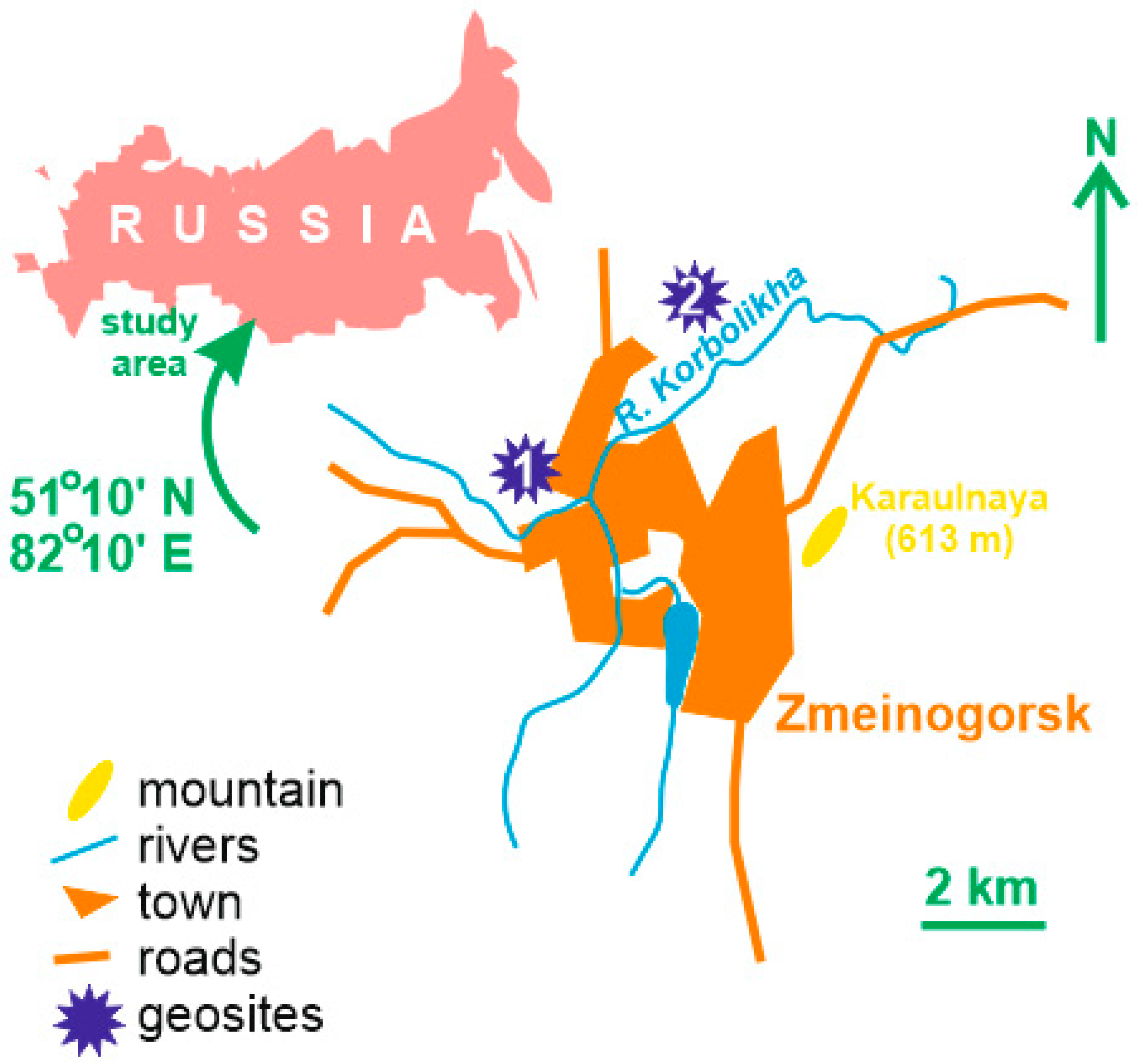
The study area is located on the western flank of the vast mountainous domain, which embraces the southern part of Siberia in Russia and some parts of China, Kazakhstan, and Mongolia. Administratively, this area belongs to the Altai Region of the Russian Federation, and it corresponds to the vicinity of the small historical town of Zmeinogorsk (Figure 1). This part of the Altai is known as the Rudny Altai, named so because of its richness in various ores (“ruda” means “ore” in Russian).
The Altai belongs to the Central Asian Orogenic Belt—a gigantic chain of orogens stretching across Eurasia [9,10]. The Altai consist of a series of elongated terranes (slices) accreted to the periphery of the former continent of Siberia (now a part of the Eurasian lithospheric plate), and one of these terranes is the Rudny Altai [11,12,13,14]. This domain of the Russian Altai is dominated by Paleozoic complexes (sedimentary, volcanic, plutonic, and metamorphic), from which the Devonian volcano-sedimentary sequences with a total thickness of up to 5000 m are the most widespread on the study area, i.e., near Zmeinogorsk [12]. These rocks were formed in a marine basin on an active periphery of the Siberian continent where the above-mentioned terranes interacted with the formation of island arcs and back-arc basins.
The most authoritative and somewhat alternative global plate tectonic reconstructions by Cao et al. [15], Golonka [16], Stampfli et al. [17], and Torsvik [18] do not shed light on the position of the Rudny Altai, but they imply that the active margin of Siberia, where this terrane evolved, was open to the Panthalassa Ocean. Therefore, the study area was covered by a marginal sea of this ocean. This is confirmed by the studies of Cocks and Torsvik [11], Domeier [19], Kuibida et al. [12], and Wilhem et al. [14], who also explained the highly complex regime of interactions of blocks now constituting the Altai. The Rudny Altai was located in tropical latitudes (approximately 30 °N) during the Devonian [11], which determined the warmth of the marginal sea and the richness of marine ecosystems.
3. Method
Fieldwork in the vicinity of Zmeinogorsk in the Rudny Altai resulted in finding two localities representing potentially unique features. These are Melnichnye Sopki and Zavodskie Sopki (Figure 1). Each can be proposed as a geosite. There are different approaches of geosite assessment [4,20,21], but, in fact, this procedure is not (and probably cannot be) standardized, and specialists tend to report geosites depending on their own vision and the needs of a particular research project. Nonetheless, it is commonly accepted that geosites should be characterized geologically, their uniqueness has to be argued, and some “technical” peculiarities require attention.
For the purposes of this study, the algorithm is used as follows. First, the location, state, and geological essence of each geosite are described. Second, the uniqueness of geological phenomena represented there is argued via demonstration of their exceptional (rare) character. Third, geological characteristics of geosites permit outlining their main features that can be assigned to geoheritage types. The classification by Ruban [22], which was updated later by the same author [23], is employed. A total of 18 types are distinguished, namely, stratigraphical, palaeontological, palaeogeographical, tectonic, cosmogenic, igneous, sedimentary, metamorphic, geothermal, mineralogical, geochemical, geomorphological, engineering, geocryological, pedological, hydro(geo)logical, economical, and geohistorical types. The palaeogeographical type is addressed in detail, and the relevant scheme of Bruno et al. [24] amended by Habibi et al. [25] is preferred. This type consists of facies, palaeoecosystem, ichnological, taphonomic, event, geoarchaeological, and palaeomapping subtypes. Fourth, accessibility, complexity (difficulty to understand), and vulnerability to anthropogenic pressure are examined. Fifth, geoconservation requirements are prescribed with regard to the common practices of geosite maintenance [3]. The aim of this study is to report new marine geoheritage, which explains the qualitative and descriptive manner of the present work.
4. Results
4.1. Melnichnye Sopki
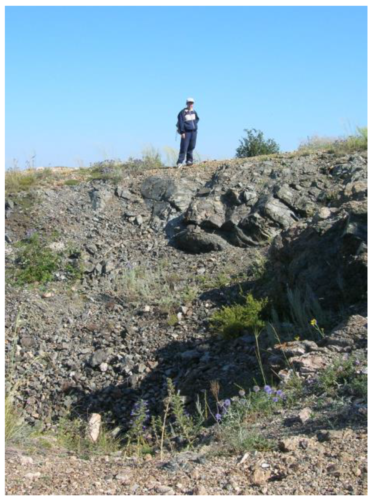
The Melnichnye Sopki geosite is located at the northwestern edge of the town of Zmeinogorsk where the Lower Devonian deposits crop out in slopes of small hills on the right bank of the River Korbolikha (Figure 1). A series of outcrops serve as a stratotype of the Melnichnaya Formation [26,27]. Of special importance is the outcrop representing the Vlangaliev Beds (Figure 2). These are calcareous siltstones altered by volcanism (the so-called “Zmeinogorsk jaspers”) with a thickness of 50–60 m. These deposits bear numerous fossil marine invertebrates, including brachiopods (Davoustia, Elythina, Isopoma, Kransia, Protodouvillina, Rugosatrypa, Spinatrypina, etc.), tabulate corals (Adetopora, Alveolites, Coenites, Pachyfavosites, Placocoenites, Tyrganolites, Thamnopora, Squameofavosites, etc.), crinoids (Anthinocrinus, Hexacrinites, Mediocrinus, Polyporocrinus, Salairocrinus, etc.), trilobites, conodonts, and ostracods; macrofloral remains (Drephanophycus, Margophyton, and Savdonia) and spores are found at the base of these beds. The Vlangaliev Beds accumulated in shallow-marine conditions on slopes of a submarine volcano with a reef on its top, as suggested by their lithological and palaeontological peculiarities. The age of these deposits is Emsian (~400 Ma) [26,27].
The uniqueness of this geosite is linked to its selection as a stratotype (each stratigraphical unit has one stratotype, which is unique by definition), highly specific sedimentary rocks, palaeontological richness with a mix of marine (invertebrates) and terrestrial (flora) elements, and very rare example of a marine palaeoecosystem populating an ancient submarine volcano. This geosite seems to be complex, and it comprises stratigraphical, sedimentary, palaeontological, and palaeogeographical types. The palaeogeographical type is represented by facies (specific depositional environment), palaeoecosystem (specific fossil assemblage), and taphonomic (specific fossil preservation) subtypes. The geohistorical type should also be recognized—silver was mined at this locality in the 19th century, and the entrance to a historical mine still exists. The location of this geosite (Figure 1) makes it perfectly accessible. Indeed, its comprehension requires a professional interpretation that is facilitated by the availability of the local publications [26]. Although the locality is not disturbed by anthropogenic activity now, it appears to be vulnerable due to its relatively small size and potentially quick coverage by rock debris that can be triggered by humans.
Undoubtedly, the Melnichnye Sopki geosite requires careful geoconservation. First, it should be officially designated as both a natural monument and an object of geological heritage (the Russian legislation offers these statuses). Second, it should be permanently monitored by the local nature protection authorities for timely rock debris clearing and avoidance of fossil overcollection. Third, a simple interpretative panel explaining its geological uniqueness and protection status needs to be installed.
4.2. Zavodskie Sopki
The Zavodskie Sopki geosite is located to the north of Zmeinogorsk where the Middle–Upper Devonian deposits are exposed in a quarry (Figure 1). These are siliceous siltstones with shale and volcaniclastic interbeds of the lower Kamenevskaya Formation and a total thickness of ~20 m (Figure 3) [26]. These deposits are rich in fossils (Figure 3), and, particularly, they bear ammonoids (Pharciceras, Tamarites, and Trianoceras), brachiopods (Aulacella and Emanuella), and conodonts. The lower Kamenevskaya Formation accumulated in relatively deep-marine conditions (as suggested by the faunal assemblage and its taphonomic peculiarities) and also on slopes of a volcanic edifice where grey smokers were active. The age of these deposits is Givetian (~385 Ma) [26].
The uniqueness of this geosite is linked to its palaeontological richness and that this is the only Russian locality of the stratigraphically important representative of Pharciceras, as well as to the volcanism-controlled depositional environment. In regard to these unique features, this geosite can be assigned to paleontological and palaeogeographical types, the latter of which is represented by facies (depositional environment), paleoecosystem (fossil assemblage), and taphonomic (fossil preservation—see Figure 3) subtypes. This geosite is a quarry connected by a road with the town, and, thus, it is well-accessible. Comprehension of this geosite requires professional interpretation. The geosite is vulnerable—in the case of abandonment, it can be “masked” by rock debris and vegetation; however, there is also a significant risk for fossil overcollection or damage of exposed ammonoid shells.
The Zavodskie Sopki geosite needs geoconservation activities, which are exactly the same as prescribed for the first proposed geosite. However, in this case, it could also be sensible to construct a fence prohibiting unauthorized visits. The interpretation panel should pay more attention to the paleontological uniqueness of this locality and warn against unprofessional fossil collecting.
5. Discussion and Conclusions
Despite certain differences, the two proposed geosites share common peculiarities. First, both reflect highly specific, volcanism-influenced marine palaeoenvironments. Although volcanic geoheritage has been reported from many places of the world [28,29,30], the relevant geosites are often linked to Cenozoic terrestrial volcanoes. The reported geoheritage turns attention to mid-Paleozoic submarine volcanoes. Second, the two proposed geosites represent rich biotic communities of the mid-Paleozoic tropical seas. If so, these seem to be valuable equally to some other geosites like those reported from Germany [31] and Vietnam [32]. More generally, these lines of evidence demonstrate the importance of the Russian Altai for marine geoheritage.
According to Brilha [20], geoheritage can be exploited for the purposes of geoscience research, geoeducation, and geotourism. The utility of the two proposed geosites should be addressed accordingly. Although these were investigated previously [26,27], both retain the significant potential for further research to be linked to their stratigraphical importance and paleontological richness. New material from these localities can be used for the improvement of the regional correlation of the Devonian deposits and finding new and taxonomic reconsidering the earlier-found fossils. These geosites are already used in the university student field practices (Figure 3) because they allow for the demonstration of the basic principles of stratigraphy and careful fossil collecting.
The tourism importance of these geosites is also big. Zmeinogorsk boasts significant historical and mining heritage that reflects the history of Russian settlement and natural resource exploitation in the Altai. This town was founded in 1736 as a center of silver and lead mining, as well as a fortress. The local mining activity played important role in the silver production in Russia until the end of the 19th century (mining was partly revitalized in the Soviet times). This activity was linked to significant innovations like the construction of the first Russian cast-iron railroad in 1809. Presently, this town counts more than 30 historical buildings and museums that display its mining and historical heritage. The tourist attractiveness of Zmeinogorsk is indisputable, and a special program of tourism development has been realized on a municipal level. Local tourism offers can be diversified with geotourism activities on the basis of the proposed geosites, which is relatively easy to do because of strong links between geological and mining heritage.
The relative vulnerability and the high complexity of these geosites imply the necessity of geoconservation procedures (see above for recommendations) to avoid tourism-related damage, as well as to provide a professional interpretation of the local geoheritage. Although both tasks can be solved with the support of any town museum, a more advanced solution would be geopark creation. The international experience proves the importance of geoparks in sustainable geoheritage management and its balanced coupling of geotourism with other tourist activities [33]. Integration of geological and mining heritage in geoparks is efficient in regard to its conservation, branding, and infrastructure development [34,35,36]. As shown above, Zmeinogorsk and its local area boast geological and mining heritage that is strongly related to the history of this area; moreover, the latter hosts museums and other tourist attractions. These are strong premises for geopark creation, which can also contribute to local sustainable development in the future.
Conclusively, this work reports a new marine geoheritage from the Russian Altai, which is represented by two geosites. Both shed light on the palaeoenvironments and the palaeoecosystems of the Devonian tropical marginal sea with active submarine volcanism. These geosites can be used for the purpose of geoscience research, geoeducation, and geotourism, and they can be included in a future geopark comprising the geological and mining heritage of Zmeinogorsk and its vicinity. This paper also indicates the geoheritage potential of the entire Russian Altai and the Rudny Altai as its part. Inventory of potentially unique features should become more active there, particularly, to find interesting and scientifically important evidence of the Paleozoic sedimentation and evolution of life in the marginal seas of the Panthalassa Ocean.
Author Contributions
Conceptualization, J.M.G. and D.A.R.; methodology, D.A.R. and N.N.Y.; investigation, J.M.G. and D.A.R.; resources, J.M.G.; writing—original draft preparation, J.M.G., D.A.R., and N.N.Y. All authors have read and agreed to the published version of the manuscript.
Funding
This research received no external funding.
Acknowledgments
The authors gratefully thank the journal editors for their support, as well as A. Milia (Italy) and the other, anonymous reviewer for their thorough examination of this manuscript and helpful recommendations.
Conflicts of Interest
The authors declare no conflict of interest.
References
- Dowling, R.; Newsome, D. (Eds.) Handbook of Geotourism; Edward Elgar: Cheltenham, UK, 2018. [Google Scholar]
- Olafsdottir, R.; Tverijonaite, E. Geotourism: A Systematic Literature Review. Geosciences 2018, 8, 234. [Google Scholar] [CrossRef] [Green Version]
- Prosser, C.; Murphy, M.; Larwood, J. Geological Conservation: A Guide to Good Practice; English Nature: Peterborough, UK, 2006. [Google Scholar]
- Reynard, E.; Brilha, J. (Eds.) Geoheritage: Assessment, Protection, and Management; Elsevier: Amsterdam, The Netherlands, 2018. [Google Scholar]
- Wimbledon, W.A.P.; Smith-Meyer, S. (Eds.) Geoheritage in Europe and Its Conservation; ProGEO: Oslo, Norway, 2012. [Google Scholar]
- Chlachula, J. Geo-tourism perspectives in East Kazakhstan. Geogr. Environ. Sustain. 2019, 12, 29–43. [Google Scholar] [CrossRef]
- Huang, S. The distribution and protection of the geological heritages in Xinjiang. Acta Geogr. Sin. 2006, 61, 227–240. [Google Scholar]
- Korf, E.D.; Filandysheva, L.B.; Naranhuu, E.; Otgonbayar, D. Georesources of the Greate Altai as a Basis for the Creation of a Transnational Geopark. IOP Conf. Ser. Earth Environ. Sci. 2018, 204, 012018. [Google Scholar] [CrossRef]
- Jahn, B.-M. The Central Asian Orogenic Belt and growth of the continental crust in the Phanerozoic. Geol. Soc. Spec. Publ. 2004, 226, 73–100. [Google Scholar] [CrossRef]
- Windley, B.F.; Alexeiev, D.; Xiao, W.; Kröner, A.; Badarch, G. Tectonic models for accretion of the Central Asian Orogenic Belt. J. Geol. Soc. 2007, 164, 31–47. [Google Scholar] [CrossRef] [Green Version]
- Cocks, L.R.M.; Torsvik, T.H. Siberia, the wandering northern terrane, and its changing geography through the Palaeozoic. Earth Sci. Rev. 2007, 82, 29–74. [Google Scholar] [CrossRef]
- Kuibeda, M.L.; Murzin, O.V.; Kruk, N.N.; Safonova, I.Y.; Sun, M.; Komiya, T.; Wong, J.; Aoki, S.L.; Murzina, N.M.; Nikolaeva, I.; et al. Whole-rock geochemistry and U-Pb ages of Devonian bimodal-type rhyolites from the Rudny Altai, Russia: Petrogenesis and tectonic settings. Gondwana Res. 2020, 81, 312–338. [Google Scholar] [CrossRef]
- Sengör, A.M.C.; Natal’In, B.A.; Sunal, G.; Van Der Voo, R. The Tectonics of the Altaids: Crustal Growth during the Construction of the Continental Lithosphere of Central Asia between ~750 and ~130 Ma Ago. Annu. Rev. Earth Planet. Sci. 2018, 46, 439–494. [Google Scholar] [CrossRef]
- Wilhem, C.; Windley, B.F.; Stampfli, G.M. The Altaids of Central Asia: A tectonic and evolutionary innovative review. Earth Sci. Rev. 2012, 113, 303–341. [Google Scholar] [CrossRef] [Green Version]
- Cao, W.; Zahirovc, S.; Flament, N.; Williams, S.; Golonka, J.; Müller, R.D. Improving global paleogeography since the late Paleozoic using paleobiology. Biogeosciences 2017, 14, 5425–5439. [Google Scholar] [CrossRef] [Green Version]
- Stampfli, G.M.; Hochard, C.; Vérard, C.; Wilhem, C.; von Raumer, J. The formation of Pangea. Tectonophysics 2013, 593, 1–19. [Google Scholar] [CrossRef] [Green Version]
- Golonka, J. Late Devonian paleogeography in the framework of global plate tectonics. Glob. Planet. Chang. 2020, 186, 103129. [Google Scholar] [CrossRef]
- Torsvik, T.H. Earth History: A journal in time and space from base to bottom. Tectonophysics 2019, 760, 297–313. [Google Scholar] [CrossRef]
- Domeier, M. Early Paleozoic tectonics of Asia: Towards a full-plate model. Geosci. Front. 2018, 9, 789–862. [Google Scholar] [CrossRef]
- Brilha, J. Inventory and quantitative assessment of geosites and geodiversity sites: A review. Geoheritage 2016, 8, 119–134. [Google Scholar] [CrossRef] [Green Version]
- Štrba, L.; Rybár, P.; Baláž, B.; Molokác, M.; Hvizdák, L.; Kršák, B.; Lukác, M.; Muchová, L.; Tometzová, D.; Ferencíková, J. Geosite assessments: Comparison of methods and results. Curr. Issues Tour. 2015, 18, 496–510. [Google Scholar] [CrossRef]
- Ruban, D.A. Quantification of geodiversity and its loss. Proc. Geol. Assoc. 2010, 121, 326–333. [Google Scholar] [CrossRef]
- Ruban, D.A. Geological Heritage of the Anthropocene Epoch—A Conceptual Viewpoint. Heritage 2020, 3, 19–28. [Google Scholar] [CrossRef] [Green Version]
- Bruno, D.E.; Crowley, B.E.; Gutak, J.M.; Moroni, A.; Nazarenko, O.V.; Oheim, K.B.; Ruban, D.A.; Tiess, G.; Zorina, S.O. Paleogeography as geological heritage: Developing geosite classification. Earth Sci. Rev. 2014, 138, 300–312. [Google Scholar] [CrossRef]
- Habibi, T.; Ruban, D.A.; Yashalova, N.N. The Nowdan anticline of the Zagros orogen as a geoheritage ‘window’ into the late Mesozoic-Cenozoic evolution of the African-Arabian continental margin. Geologos 2020, 26, 65–73. [Google Scholar] [CrossRef]
- Gutak, J.M.; Murzin, O.V.; Zhdanov, V.A.; Lyakhnitskiy, V.N.; Petrunina, Z.E.; Rodygin, S.A. Opornye razrevy devona Rudnogo Altaja i granitsa srednego i verkhnego Devona. In Devonian of the Rudny Altai and the Boundary of the Middle and Upper Devonian; MSK: Zmeinogorsk, Russia, 2000. (In Russian) [Google Scholar]
- Zheltonogova, V.A.; Gutak, J.M.; Gratsianova, R.T.; Galenko, L.V. Ejfel’skij jarus devona Rudnogo Altaja: Biostratigrafija po brakhiopodam i korallam, paleogeografitcheskie svjazi fauny [The Eifelian Stage of the Devonian of the Rudny Altai: Biostratigraphy by brachiopods and corals, palaebiogeographical connections of fauna]. Geolog. Geofiz. 1994, 1, 25–33. (In Russian) [Google Scholar]
- Migoń, P.; Pijet-Migoń, E. Overlooked Geomorphological Component of Volcanic Geoheritage—Diversity and Perspectives for Tourism Industry, Pogórze Kaczawskie Region, SW Poland. Geoheritage 2016, 8, 333–350. [Google Scholar] [CrossRef]
- Németh, K.; Moufti, M.R. Geoheritage Values of a Mature Monogenetic Volcanic Field in Intra-continental Settings: Harrat Khaybar, Kingdom of Saudi Arabia. Geoheritage 2017, 9, 311–328. [Google Scholar] [CrossRef]
- Pasquaré Mariotto, F.; Bonali, F.L.; Venturini, C. Iceland, an open-air museum for geoheritage and earth science communication Purposes. Resources 2020, 9, 14. [Google Scholar] [CrossRef] [Green Version]
- Bohatý, J.; Herbig, H.-G. Middle Givetian echinoderms from the Schlade Valley (Rhenish Massif, Germany): Habitats, taxonomy and ecostratigraphy. Palaontol. Z. 2010, 84, 365–385. [Google Scholar] [CrossRef]
- Phuong, T.H.; Cu, N.H.; Thanh, T.D.; Van Dong, B. Geoheritage values in the Cat Ba islands, Vietnam. Environ. Earth Sci. 2013, 70, 543–548. [Google Scholar] [CrossRef]
- Henriques, M.H.; Brilha, J. UNESCO Global Geoparks: A strategy towards global understanding and sustainability. Episodes 2017, 40, 349–355. [Google Scholar] [CrossRef]
- Cañizares Ruiz, M.C. Visibility and promotion of mining heritage in some Spanish geoparks. Doc. d’Anal. Geogr. 2020, 66, 109–131. [Google Scholar] [CrossRef]
- Mossa, A.; Camúñez-Ruiz, J.A.; Morandi, F. Current state of the first UNESCO global geopark: A case study of the geological and mining park of Sardinia, Italy. Geoj. Tourism Geosites 2018, 22, 403–418. [Google Scholar]
- Ramsay, T. Fforest Fawr Geopark—a UNESCO Global Geopark distinguished by its geological, industrial and cultural heritage. Proc. Geol. Assoc. 2017, 128, 500–509. [Google Scholar] [CrossRef]
Figure 1.
Location of the study area and the proposed geosites; 1. Melnichnye Sopki and 2. Zavodskie Sopki.
Figure 1.
Location of the study area and the proposed geosites; 1. Melnichnye Sopki and 2. Zavodskie Sopki.

Figure 2.
Melnichnye Sopki geosite.

Figure 3.
Zavodskie Sopki geosite (ammonoid fossil is shown in insert figure, and geoeducational activity is also shown).
Figure 3.
Zavodskie Sopki geosite (ammonoid fossil is shown in insert figure, and geoeducational activity is also shown).

Publisher’s Note: MDPI stays neutral with regard to jurisdictional claims in published maps and institutional affiliations. |
© 2021 by the authors. Licensee MDPI, Basel, Switzerland. This article is an open access article distributed under the terms and conditions of the Creative Commons Attribution (CC BY) license (http://creativecommons.org/licenses/by/4.0/).
Share and Cite
MDPI and ACS Style
Gutak, J.M.; Ruban, D.A.; Yashalova, N.N. New Marine Geoheritage from the Russian Altai. J. Mar. Sci. Eng. 2021, 9, 92. https://0-doi-org.brum.beds.ac.uk/10.3390/jmse9010092
AMA Style
Gutak JM, Ruban DA, Yashalova NN. New Marine Geoheritage from the Russian Altai. Journal of Marine Science and Engineering. 2021; 9(1):92. https://0-doi-org.brum.beds.ac.uk/10.3390/jmse9010092
Chicago/Turabian StyleGutak, Jaroslav M., Dmitry A. Ruban, and Natalia N. Yashalova. 2021. "New Marine Geoheritage from the Russian Altai" Journal of Marine Science and Engineering 9, no. 1: 92. https://0-doi-org.brum.beds.ac.uk/10.3390/jmse9010092
Note that from the first issue of 2016, this journal uses article numbers instead of page numbers. See further details here.