Review

Tracking Marine Alien Macroalgae in the Mediterranean Sea: The Contribution of Citizen Science and Remote Sensing

by
Anna Maria Mannino
1,*,
Flavio Borfecchia
2 and
Carla Micheli
3
1
Department of Biological, Chemical and Pharmaceutical Sciences and Technologies, University of Palermo, 90123 Palermo, Italy
2
ENEA External Collaborator, 00123 Rome, Italy
3
Department of Energy Technologies and Renewable Sources, ENEA, Italian National Agency for New Technologies, Energy and Sustainable Economic Development, TERIN-BBC-BBE, Research Centre Casaccia, 2400/00123 Rome, Italy
*
Author to whom correspondence should be addressed.
J. Mar. Sci. Eng. 2021, 9(3), 288; https://0-doi-org.brum.beds.ac.uk/10.3390/jmse9030288
Submission received: 12 February 2021 / Revised: 2 March 2021 / Accepted: 2 March 2021 / Published: 6 March 2021
(This article belongs to the Special Issue Diversity, Taxonomy and Conservation of Marine Algae)

Abstract

:
The accelerating rate of the introduction of non-indigenous species (NIS) and the magnitude of shipping traffic make the Mediterranean Sea a hotspot of biological invasions. For the effective management of NIS, early detection and intensive monitoring over time and space are essential. Here, we present an overview of possible applications of citizen science and remote sensing in monitoring alien seaweeds in the Mediterranean Sea. Citizen science activities, involving the public (e.g., tourists, fishermen, divers) in the collection of data, have great potential for monitoring NIS. The innovative methodologies, based on remote sensing techniques coupled with in situ/laboratory advanced sampling/analysis methods for tracking such species, may be useful and effective tools for easily assessing NIS distribution patterns and monitoring the space/time changes in habitats in order to support the sustainable management of the ecosystems. The reported case studies highlight how these cost-effective systems can be useful complementary tools for monitoring NIS, especially in marine protected areas, which, despite their fundamental role in the conservation of marine biodiversity, are not immune to the introduction of NIS. To ensure effective and long-lasting management strategies, collaborations between researchers, policy makers and citizens are essential.

1. Introduction

Non-indigenous species (NIS), organisms introduced from beyond their natural (past or present) geographical region and outside of their natural dispersal potential, are a major threat to biodiversity and natural ecosystem functioning [1,2,3,4]. NIS that have large established and expanding populations may become invasive alien species (IAS), which could result in significant environmental, socioeconomic and human health impacts [2,5,6,7,8].
In the marine environment, IAS may have substantial negative impacts on native biota (e.g., substitution of native species and biodiversity loss due to habitat modifications, alterations in community structure and ecosystem service changes) [4,5,9]. For instance, they compete with native species, and may change native benthic communities, perhaps leading to an impoverishment of subtidal communities [10,11]. Moreover, they may cause degradation of seagrass meadows, having a severe negative impact on coastal protection [5].
The high number of NIS make the Mediterranean Sea a genuine hotspot for marine biological invasions, in terms of both the number of species and the rate of introduction [12,13,14]. The conspicuous increase in the rates of introduction and expansion of NIS can be correlated with the intensified research efforts involving marine NIS and the increase of stakeholder involvement and of citizen science initiatives [14,15].
Marine protected areas (MPAs), whose major aim is biodiversity conservation, may be highly affected by NIS invasions, and the impact of NIS on marine resources and habitats can be significant, even highly detrimental [16,17,18,19,20]. To date, the effect of MPAs on NIS is still not fully understood, and it is unclear whether or not MPAs favor NIS expansion via tourism activities, e.g., boat anchors and diving [21,22,23]. Since NIS represent serious threats at multiple levels, they have to be targeted by scientists, conservation managers, policy makers and citizens to increase the amount of information on their distribution and spread dynamics and impacts, with the main goal of taking prevention and mitigation measures. In the marine realm, the management of NIS is particularly difficult [24]. Prevention is certainly the cheapest and most cost-effective option for reducing the risk of future NIS introduction and the spread of ones that have already emerged [25]. In this respect, monitoring and surveillance plans, which greatly assist managers and policy makers in their decisions on the prevention or mitigation actions to be taken, are crucial. Regularly updated, space-temporal information on the distribution and abundance of NIS is fundamental for the assessment of effective management plans [26,27]. However, traditional monitoring and mapping methods (field survey and sampling campaigns) are time-consuming, costly and limited in space and time. In this respect, citizen science activities and remote sensing may be useful complementary tools for monitoring the distribution and spread of NIS.
Citizen science activities, involving the public (e.g., tourists, fishermen, divers) in the collection of data (regularly updated and validated by scientists), in addition to their important role in educating and improving public awareness, could be useful resources for collecting space-temporal information on NIS distribution, abundance and spread [19,28,29,30]. When properly designed, citizen science activities can provide scientifically reliable data on species’ distribution and abundance [30,31]. Currently, the number of citizen science initiatives has increased enormously thanks to the new technologies and social media [15,19,32].
Remote sensing techniques (RS), using passive multispectral imaging sensors, operating in the visible (VIS), near infrared (NIR) and shortwave infrared (SWIR) on both satellite and airborne platforms, have been even more widely used for providing Earth observation (EO) data for the continuously growing applications in different sectors, including sea water monitoring at different scales [33,34,35,36]. In particular, these optical sensors, measuring the energy reflected and emitted from the Earth’s surface, allow researchers to not only map the extent of shallow benthic or intertidal marine habitats, but also to identify key marine species [37]. Satellite sensors at intermediate ground resolution (0.3–1 km), such as the moderate resolution image spectrometer (MODIS), managed by NASA, or Sentinel-3, operated by ESA, systematically provide the so-called “Ocean Color” data. This information, linked to parameters like chlorophyll or pigment concentration, can even support the detection and monitoring of NIS in shallow water seabeds, floating on the sea surface or in the water column. In general, mapping NIS through RS in coastal and shallow water may require higher ground resolution that can be suitably supported by other remote sensing sensors, which are currently available and based on airborne (including UAV—unmanned aerial vehicle) or other high-resolution (HR) orbiting satellites and very high-resolution (VHR) optical sensors. The HR satellites can provide a repetitive coverage for monitoring evolving phenomena with ground resolution until 30 m (i.e., Landsat 8 Operational Land Imager (OLI) operated by NASA, and Sentinel-2 MultiSpectral Instrument (MSI) operated by ESA).
In addition, the same ground resolution is provided by the PRISMA (Hyperspectral Precursor of the Application Mission) hyperspectral sensor, made recently available by the Italian Space Agency (ASI), which, because of its hundreds of acquisition bands in the spectral ranges of interest, may constitute a very promising tool in this specifying sector. Moreover, the currently available sensors based on satellite (VHR), airborne or UAV technologies, may provide tailored solutions to specific seabed, water quality and NIS detection and monitoring needs [34]. Once suitably corrected for atmospheric noises (e.g., turbidity, clouds), the EO data provided by this new generation of polar satellite multi/hyperspectral sensors have proven to be effective and operative for environmental conservation and the monitoring of the coastal marine ecosystems and water quality, even in moderately turbid shallow waters [35,36].
These RS techniques are recognized as effective tools for determining species diversity and distribution, for quantifying biomass and primary production, as obtained from the photosynthetically available radiation (PAR) and leaf area index (LAI), and for monitoring their changes over space and time in shallow waters [36,38,39,40,41,42,43]. In any case, they must be combined with in situ measurements [44] of biophysical parameters of interest in order to support the proper calibration/validation of the EO data. Moreover, these data may be widely exploited for the multiscale/multitemporal systematic monitoring and mapping of the increasing presence of NIS in shallow water and marine ecosystems, which are typically affected by their worldwide spread, driven by rising effects of oil/gas shipping (especially in the Mediterranean Sea), eutrophication/pollution and climate change. When the high water turbidity (>100 NTU—Nephelometric Turbidity Units)) limits the exploitation of RS techniques, the vertical side-scan sonar can be a suitable acoustic integrated tool for mapping the vegetation, including NIS, on the seabed of coastal zones [45].
As biological invasions are highly impacting the Mediterranean Sea biodiversity, and many coastal zones and shallow waters are vulnerable to NIS invasion, the use of cost-effective systems, e.g., citizen science and remote sensing, may offer many important contributions to the knowledge and management of NIS [19,46,47,48].
In this paper we demonstrate that citizen science and the operative multispectral satellite sensors (remote sensing) can be used as effective complementary tools for scientific and extensive monitoring in the Mediterranean Sea, with potential as NIS early warning and monitoring systems, fundamental to support ecosystem-based sustainable management. Relevant literature, updated until November 2020, was searched for using standard scientific databases (e.g., Google Scholar, Web of Science, Scopus and ResearchGate) and analyzed. The search was performed using various combinations of the following list of keywords on the subject: “citizen science”, “remote sensing”, “marine”, “alien”, “non-indigenous”, “invasive”, “species”, “macroalgae”, “Mediterranean Sea”.

2. Citizen Science

Out of 17 records, only 5 were related to alien seaweeds and citizen science activities. Indeed, the great majority of records concerned the monitoring of marine invasive fishes (e.g., the project “AlienFish” launched by Ente Fauna Marina Mediterranea and the project “Is it Alien to you? Share it!!!” launched by the iSea online platform) [15,49,50,51]. All of the five selected papers (hereafter referred to as the cases), were related to the monitoring of three invasive Caulerpa taxa, Caulerpa cylindracea Sonder (along the Sicilian and Ligurian coasts, in the western Mediterranean), Caulerpa taxifolia (M. Vahl) C. Agardh (Spanish, French, Italian and Croatian coasts) and Caulerpa taxifolia var. distichophylla (Sonder) Verlaque, Huisman and Procaccini (along the Maltese coasts, in the central Mediterranean) in the Mediterranean Sea [19,52,53,54,55,56,57,58] (Figure 1). All the Caulerpa taxa showed invasive behavior with significant impacts on the native communities.
According to the authors of [59], C. cylindracea was first recorded in the Mediterranean Sea off the coasts of Libya in 1990, whereas the authors of [60] date the first record back to 1985 in Tunisia. This alga is able to compete with native species and may change native benthic communities, leading to an impoverishment of subtidal communities [10,11,61]. In particular, it may enter into competition with native seagrasses, such as Posidonia oceanica (L.) Delile, mainly when their meadows are stressed and degraded [10,62,63]. It is also able to clog and break fishing nets by the mats it forms. Caulerpa taxifolia (M. Vahl) C. Agardh (invasive aquarium strain) was first recorded in the Mediterranean in 1984 [62]. It affects photophilic algal communities, causing a drastic reduction in diversity, and it is also able to compete with P. oceanica (for the interception of light or the utilization of nutrients) and interfere with it by the production of secondary metabolites (allelopathy) [64,65]. Caulerpa taxifolia var. distichophylla is the most recently introduced Caulerpa in the Mediterranean Sea. It was first recorded in Syria in 2003 ([66] as C. mexicana). It showed invasive behavior in Sicilian waters, with significant impacts on native ecosystems [67,68,69]. Similar to C. cylindracea, it is also able to clog and break fishing nets [67].
Cases 1 and 2, referring to the monitoring of C. cylindracea with the exclusive involvement of citizen scientists, also stressed the second mission of citizen science activities, i.e., to promote environmental and scientific education and awareness in engaged participants. Case 3 refers to a monitoring campaign (1991–1992) on C. taxifolia organized in the Mediterranean coast of France [52], involving sea users to whom brochures on the species were distributed. Case 4 was related to international campaigns for public awareness on C. taxifolia, supported by the European Commission (see [54]), organized by French, Italian, Spanish and Croatian scientists, who elaborated leaflets and posters for distribution to sea users. In Case 5, the involvement of citizen scientists (e.g., snorkelers and recreational divers) in the monitoring of C. taxifolia var. distichophylla was a complementary activity to the field research surveys.

2.1. Western Mediterranean
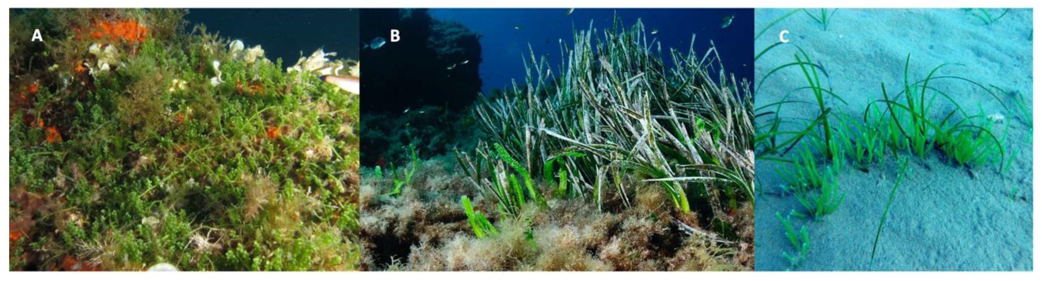
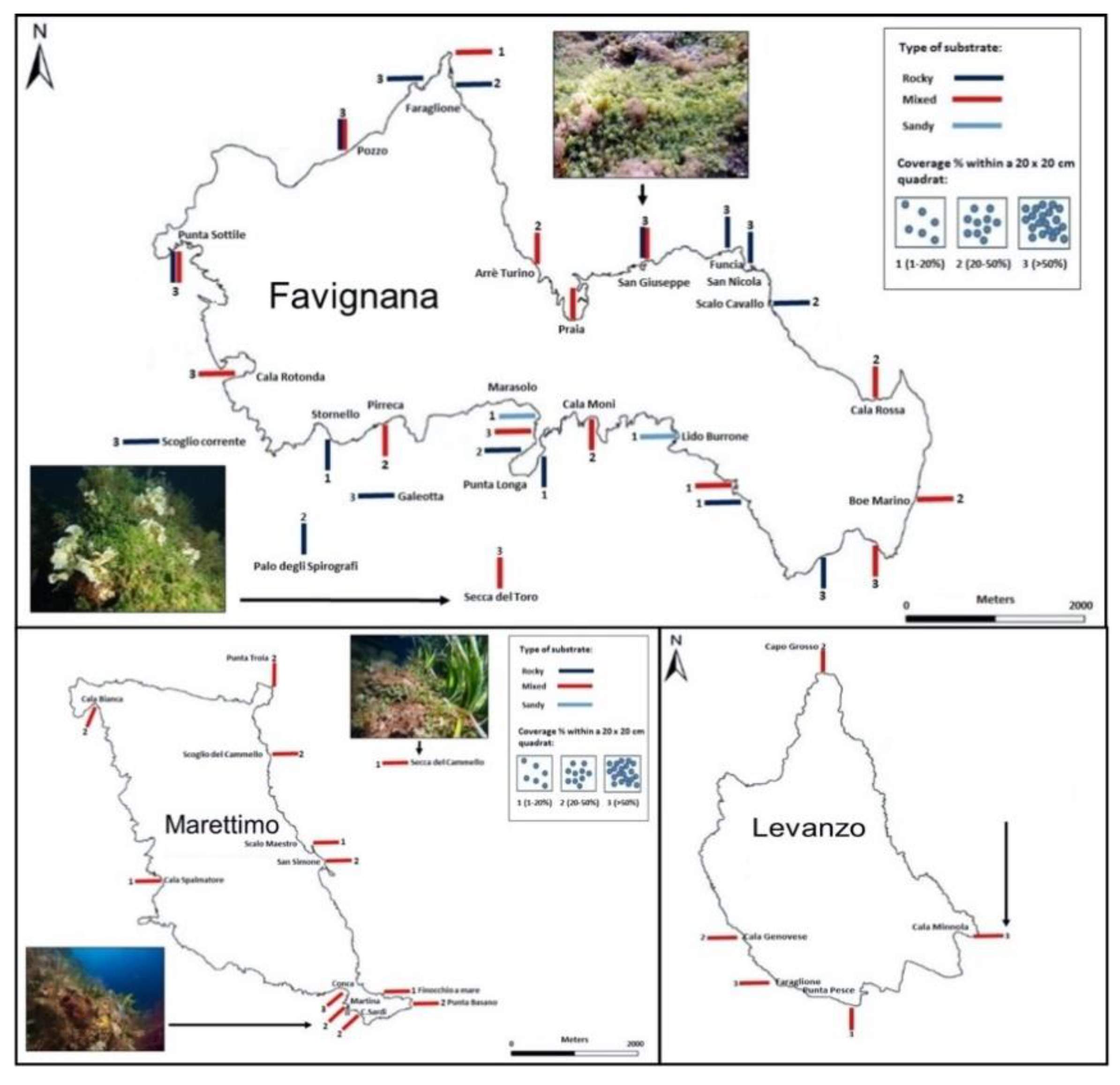
2.1.1. Case 1

Case 1 refers to the citizen science project “Caulerpa cylindracea–Egadi Islands” [19,55], addressed to different groups of volunteers (i.e., citizens, fishermen, snorkelers and divers) that aimed to collect data (place, date, depth and substrate coverage %) and photos on the distribution of C. cylindracea within the Egadi Islands MPA (Aegadian archipelago). Data were sent through a mail address, a Facebook page, the MPA website or with the filling in of a form available online or in the MPA’s offices. This MPA (instituted in 1991), the largest Italian MPA, is located approximately 7–9 km from the western coast of Sicily (Italy, Tyrrhenian Sea). Only data validated by the scientific team of the project were gathered in the database.
The project registered approximately 160 sightings of C. cylindracea, mainly recorded at Favignana, the largest island. The alga was found in different habitats, between 0 and 40 m depth, on rock, rock with sediment and sand. It was also recorded in valuable habitats such as vermetid reefs, Cystoseira communities (upper infralittoral zone) and coralligenous formations (Figure 2). The alga was more frequent in Cystoseira communities and vermetid reefs than in coralligenous formations, showing coverage values mainly ranging from 20% to 50%, but also reaching values higher than 50% in the vermetid reefs. Anchoring activities, mainly carried out by pleasure boats, seem to have encouraged the spread of C. cylindracea. This was also highlighted by some biological traits of the alga, e.g., the ability of creating bridges with its stolons over native communities and forming compact multilayered mats that were able to trap the sediment.
Records concerning other NIS and cryptogenic species (see Reference [71]: a species that cannot be included with confidence among native nor among introduced species) were also gathered, e.g., Asparagopsis taxiformis (Delile) Trevisan, Aplysia dactylomela (Rang, 1828), Fistularia commersoni (Rüppel, 1838), Rhopilema nomadica (Galil, Spannier and Ferguson, 1990) and the biofouler worm Branchiomma bairdi (McIntosh, 1885), and would have been favored by the increase of sedimentation among the stolons of C. cylindracea. In the wake of this project, the project “Aliens in the sea”, which aimed to collect data on 19 NIS (including C. cylindracea) along the Sicilian coasts, was launched in 2017. The project is still active and allowed for the gathering of new records of C. cylindracea from the Egadi Islands MPA [32].

2.1.2. Case 2

Case 2 was related to the monitoring of C. cylindracea along the Ligurian coast, including the Portofino MPA [57]. The monitoring was carried out by Reef Check Italia Onlus (RCI), a non-profit organization involving volunteer divers in the Mediterranean Sea that developed protocols for coastal environment monitoring. Volunteer divers, after a one-day intensive training course, were able to make observations on the presence/absence and abundance of the target species.
The monitoring (2006–2014) provided useful information on the spread of this IAS, highlighting the expansion in distribution and abundance of this alga. Since 2006, the species has spread rapidly and new sites have been recorded. Caulerpa cylindracea was first recorded in Portofino MPA in 2007 at San Fruttuoso Bay, one of the three boat corridors within the MPA, and since then, it has rapidly spread throughout the MPA, which appears to be severely affected by this NIS. Along the Ligurian coast, the alga was mainly recorded in the coastal rocky bottoms (74% of alga occurrences) and between 5 and 10 m depths.

2.1.3. Case 3

Case 3 refers to a monitoring campaign (1991–1992) on C. taxifolia organized in the Mediterranean coast of France [52]. Brochures were distributed to sea users, who were requested to report sightings and information on this alga. Dives were also carried out in the newly colonized sites. Data from Spain and Italy were also gathered, and a rapid increase of the spread of the alga has been observed since 1990. Useful information on the biology, ecology and dynamics invasion of the alga was also collected. Five different stages in the invasion process were described and the colonization effects on P. oceanica meadows were also observed. The authors also highlight the role that maritime traffic and fishing may play in the spreading of the alga.

2.2. Mediterranean Countries—Case 4

Case 4 was related to some monitoring campaigns on the spread of C. taxifolia conducted in Mediterranean countries affected by the invasion of this species [53,54]. The first international campaign for public awareness on C. taxifolia was organized in 1993 and 1994 by the Laboratoire Environment Marin Littoral (LEML) and supported by the European Commission (see Reference [54]). French, Italian and Spanish scientists participated in the campaign organization and distribuited elaborated leaflets and posters to sea users. In 1997, the second international campaign for public awareness was organized to map the distribution of C. taxifolia in the Mediterranean Sea (see Reference [54]). This campaign, coordinated by the LEML and the Groupement d’intérêt scientifique (GIS) Posidonie, was always supported by the European Commission. The message was, “Wanted Caulerpa taxifolia. If you find this seaweed, do not help it to spread, and phone us”. Leaflets, containing information on the biology, ecology, dissemination methods and spread of the species, were distributed to sea users in Spain, France, Italy and Croatia as well as to scientific institutions. Several institutions and associations (e.g., Lions Clubs, divers, Institut National des Sciences et Technologies de la Mer, etc.) contributed to this public awareness campaign. The majority of known locations were confirmed by sea users and new locations were gathered. All the information was rigorously verified, the sightings were mapped and the reports were regularly updated. This campaign was an effective tool for updating the distribution of C. taxifolia and also for helping to plan measures to slow down the spread of the alga. The authors of [53] described the status of C. taxifolia invasion at the end of 2000 in six Mediterranean countries (Spain, France, Monaco, Italy, Croatia and Tunisia). The data were also obtained with the support of public awareness campaigns (the distribution of pamphlets and posters). The authors reported that 80% of the area colonized was along 500 km of coastline between Toulon (France) and Genoa (Italy), supporting the hypothesis that the origin of the introduction was Monaco.

2.3. Central Mediterranean—Case 5

Case 5 refers to a monitoring activity (2016–2017) of C. taxifolia var. distichophylla in Maltese waters [58]. The citizen science monitoring activities, complementary to field surveys, lasted from July 2015 to December 2017, and in particular involved snorkelers and recreational divers. A poster with representative photographs of the alga and details on how to report the species was prepared and distributed to local diving schools and dive clubs, as well as being shared online through social media.
Records received through the citizen scientists, regularly validated, came from sites different from those surveyed by the researchers. Certainly, records from the citizen scientists provided useful information on the habitats preferred by the alga and also helped to document the significant change in the distribution of C. taxifolia var. distichophylla, confirming that the species is rapidly expanding in Maltese waters.

3. Remote Sensing

Out of six records only one record was related to alien seaweeds and remote sensing. The majority of the detected articles concerned alien plants. The paper refers to the indo-pacific NIS Hypnea cornuta (Kützing) J. Agardh in the Mar Piccolo of Taranto, where it was recorded for the first time in 2000 [72]. The first Mediterranean report of the species was from Rhodes Island, Greece (in Reference [73] as H. valentiae (Turner) Montagne).
In 2014, the distribution of H. cornuta in the Mar Piccolo was mapped using the Landsat 8 OLI multispectral optical sensor in combination with quantitative sampling. Four stations were considered within the two inlets of the Mar Piccolo of Taranto in order to carry out quantitative sampling. Thalli of H. cornuta were only found in two stations, Battendieri and Cimino, and the highest biomass values were registered at Battendieri (the station of the first finding). The map of spatial distribution was assessed by means of the EO data provided by Landsat 8 Operational Land Imager (OLI) sensor (Figure 3). The OLI multispectral data were previously corrected for atmospheric noise, scattering/attenuation from image-derived aerosol optical depth (AOD) and adjacency effects. Subsequently, they were classified using a supervised maximum likelihood (ML) parametric algorithm and trained using point sampling data. Although a thematic accuracy superior to 80% was achieved with respect to the available sea truth data, the model could be further improved by expanding the sampling schema.
The distribution map, obtained from the remote sensing satellite techniques, was in agreement with the in situ collected data, seeing as H. cornuta was confined to the second inlet of the Mar Piccolo of Taranto. On the basis of the achieved and upgradable results, the authors highlight the promising integration between the remote sensing techniques and in situ/laboratory methods for mapping the distribution of aquatic alien species in shallow waters. Thus, in general, this technology could be a useful tool for suitably supporting the sustainable management of these threatened and fragile coastal environments.

4. Discussion

Our bibliographic search highlights that, despite the fact that citizen science and remote sensing have become increasingly important for NIS monitoring, the number of papers related to alien seaweed monitoring in the Mediterranean Sea using these two techniques is still very low. In the Mediterranean Sea, remote sensing techniques have been mainly used for the detection and prediction of invasive plants and the assessment of their impact. In extra Mediterranean areas; however, these techniques are widely used for mapping NIS or floating marine algae, such as the Sargassum species [74,75]. According to the authors of [74], the compact airborne spectrographic imager (CASI) is a suitable tool for mapping NIS, such as Codium fragile spp. tomentosoides (Van Goor) P.C. Silva in Mahone Bay, Nova Scotia. Instead, several satellites were used to monitor large pelagic Sargassum in the tropical North Atlantic, in particular: the medium resolution imaging spectrometer (MERIS, on board the ENVISAT (ENVIronmental SATellite) with a spatial resolution of 300 m; the moderate resolution imaging spectroradiometers (MODIS, on board the AQUA and TERRA satellites); the visible infrared imaging radiometer suite (VIIRS, on board the SNPP (Suomi National Polar-orbiting Partnership) NASA satellite) with a coarser spatial resolution of 1 km and 750 m, respectively; the high-resolution sensors on board Landsat platforms with a 30 m resolution in coastal areas; the recently launched ESA higher resolution satellite sensors, namely, the ocean and land color instrument (OLCI, 300 m) on board the Sentinel-3; and the MultiSpectral Instrument (MSI, 60-20-10 m) on board the Sentinel-2 [75].
With respect to citizen science in the Mediterranean Sea, the great majority of papers concern the monitoring of marine invasive fishes. In extra Mediterranean areas; however, citizen scientists (fishers, bathers, sailors, volunteers from associations, etc.) have greatly supported the monitoring of NIS. For instance, in the north-eastern Atlantic Ocean, the North Sea and New Zealand, there has been monitoring of large NIS, such as Sargassum muticum (Yendo) Fensholt and Undaria pinnatifida (Harvey) Suringar [76], which are easy to map because they can also reach the sea surface; additionally, there has been good monitoring of NIS in the ports of Le Havre and Antifer (Normandy, France) [77].
Even if they are few, the reported case studies show that these two techniques may be useful tools to support the traditional methods of alien seaweed monitoring in the Mediterranean Sea. Indeed, they could be effective as early warning instruments of new introduction and as detectors of distribution changing over time.
Citizen science activities, besides improving public awareness, may be very useful in collecting data on introduction and spread of NIS over spatial and temporal scales that otherwise would remain hidden. The goal is achieved and is really effective when the activities are properly designed and communicated and volunteers are appropriately prepared and motivated. In this respect, social medias can have an important role in making the information on the temporal and spatial spread within a certain area easily available [78], and also involving as many categories of volunteers as possible (e.g., see References [49,79,80]). The higher the number of categories we involve, the higher the number of habitats which may be monitored. Since local volunteers know the environment where they live, they are the true early warners of new introductions in their area.
Recently, the interest of the scientific community in these complementary tools has increased (e.g., see References [19,79,81,82,83]) as proven by the citizen science initiatives on the monitoring of NIS launched in the Mediterranean Sea (e.g., see References [15,49,84]). Indeed, a lot of species that are easy to identify (see the reported case studies), could be included within citizen science initiatives with the dual purpose of raising awareness and early-warning detection [13,85]. Since MPAs are not immune from NIS invasions (as shown in the present study and References [18,19,32]), the involvement of local citizens is also essential for setting management actions to effectively prevent and control marine bioinvasions. Indeed, restrictions upon activities generating economic benefits (tourism, boat anchors, diving, etc.) could raise obstacles to their acceptance from the local population [86,87]. High-quality and continuously updated information on the distribution, spread dynamics, abundance, and pathways of their introduction might greatly assist managers and policy makers in prioritizing prevention or mitigation actions, and for conservation planning [2,88,89,90,91].
Advances in remote sensor/platform technologies and processing algorithms are enhancing marine habitat mapping, through an even smaller spatial resolution and better color discrimination. Even if some parameters, such as the submerged depth, may limit NIS detection and quantification from space, satellite imagery datasets with various spatial, spectral and temporal resolutions provided, for instance, by the MODIS, VIIRS, OLCI and MSI satellite sensors, are successful tools to map NIS distribution at a large scale and to detect NIS abundance consistent with in situ observations [75]. Furthermore, CASI is a promising tool for mapping and monitoring NIS in subtidal habitats [74].

5. Conclusions

Biological invasions are an ongoing phenomenon and many NIS are expanding their distribution in coastal waters with negative impacts on the environment, human health and the economy. The Mediterranean Sea is one of the most important biodiversity hotspots in the world [92], but it is also subjected to complex and severe anthropogenic pressures, e.g., biological invasions [2]. Therefore, monitoring the distribution of NIS, in order to have accurate and regularly updated information, is essential for the conservation and management of marine ecosystems and the implementation of policies [89].
To support the ecosystem-based sustainable management of affected coastal areas, rapid and accurate tools for assessing and mapping the abundance and distribution of NIS are required. For this purpose, besides the traditional methods, other powerful and cost-effective methods for monitoring and detecting NIS currently exist, including citizen science activities and EO-based innovative techniques using airborne [35] and satellite [72,74,75,93,94] platforms.
Currently, space technology is globally emerging by private spaceflight and the aerospace industry, with faster, cheaper and better access to space programs and EO data [95,96]. Citizen science is also increasingly developing thanks to technological developments, adequate training courses for citizen scientists and continuous validations of data quality [97,98]. Therefore, these space-based cost-effective methods, complementary with those for in situ sample gathering and analysis, can provide powerful tools for monitoring NIS introductions and their spread, especially in areas like MPAs. Exploiting these synergies is becoming increasingly necessary to ensure effective and long-lasting management strategies based on multidisciplinary collaborations between researchers, policy makers and citizens.

Author Contributions

Conceptualization, methodology, validation, resources, writing—review and editing, A.M.M., F.B. and C.M.; supervision, A.M.M. All authors have read and agreed to the published version of the manuscript.

Funding

This research received no external funding.

Data Availability Statement

Data sharing is not applicable to this article.

Acknowledgments

This paper was produced within the framework of the Marine Hazard project (PON-FESR 2020-2022).

Conflicts of Interest

The authors declare no conflict of interest.

References

  1. Wallentinus, I.; Nyberg, C.D. Introduced marine organisms as habitats modifiers. Mar. Pollut. Bull. 2007, 55, 323–332. [Google Scholar] [CrossRef] [PubMed]
  2. Katsanevakis, S.; Coll, M.; Piroddi, C.; Steenbeek, J.; RaisLasram, F.B.; Zenetos, A.; Cardoso, A.C. Invading the Mediterranean Sea: Biodiversity patterns shaped by human activities. Front. Mar. Sci. 2014, 1, 32. [Google Scholar] [CrossRef] [Green Version]
  3. Ojaveer, H.; Galil, B.S.; Campbell, M.L.; Carlton, J.T.; Canning-Clode, J.; Cook, E.J.; Davidson, A.D.; Hewitt, C.L.; Jelmert, A.; Marchini, A.; et al. Classification of non-indigenous species based on their impacts: Considerations for application in marine management. PLoS Biol. 2015, 13, e1002130. [Google Scholar] [CrossRef] [Green Version]
  4. Vergés, A.; Doropoulos, C.; Malcolm, H.A.; Skye, M.; Garcia-Pizá, M.; Marzinelli, E.M.; Campbell, A.H.; Ballesteros, E.; Hoey, A.S.; Vila-Concejo, A.; et al. Long-term empirical evidence of ocean warming leading to tropicalization of fish communities, increased herbivory, and loss of kelp. Proc. Natl. Acad. Sci. USA 2016, 113, 13791–13796. [Google Scholar] [CrossRef] [PubMed] [Green Version]
  5. Katsanevakis, S.; Wallentinus, I.; Zenetos, A.; Leppäkoski, E.; Çinar, M.E.; Oztürk, B.; Grabowski, M.; Golani, D.; Cardoso, A.C. Impacts of marine invasive alien species on ecosystem services and biodiversity: A pan-European review. Aquat. Invasions 2014, 9, 391–423. [Google Scholar] [CrossRef]
  6. Bellard, C.; Cassey, P.; Blackburn, T.M. Alien species as a driver of recent extinctions. Biol. Lett. 2016, 12, 623. [Google Scholar] [CrossRef] [PubMed]
  7. Gallardo, B.; Clavero, M.; Sánchez, M.I.; Vilà, M. Global ecological impacts of invasive species in aquatic ecosystems. Glob. Chang. Biol. 2016, 22, 151–163. [Google Scholar] [CrossRef]
  8. Vilà, M.; Hulme, P.E. Non-native species, ecosystem services, and human well-being. In Impact of Biological Invasions on Ecosystem Services; Vilà, M., Hulme, P., Eds.; Springer Nature: Cham, Switzerland, 2017; Volume 12, pp. 1–14. [Google Scholar]
  9. Russell, J.C.; Blackburn, T.M. Invasive alien species: Denialism, disagreement, definitions and dialogue. Trends Ecol. Evol. 2017, 32, 312–314. [Google Scholar] [CrossRef] [Green Version]
  10. Klein, J.; Verlaque, M. The Caulerpa racemosa invasion: A critical review. Mar. Pollut. Bull. 2008, 56, 205–225. [Google Scholar] [CrossRef]
  11. Matijević, S.; Bogner, D.; Bojanić, N.; Žuljević, A.; Despalatović, M.; Antolić, B.; Nikolić, V.; Bilić, J. Biogeochemical characteristics of sediments under the canopy of invasive alga Caulerpa racemosa var. cylindracea (Pelješac Peninsula, Adriatic Sea). Fresenius Environ. Bull. 2013, 22, 3030–3040. [Google Scholar]
  12. Zenetos, A.; Çinar, M.E.; Crocetta, F.; Golani, D.; Rosso, A.; Servello, G.; Shenkar, N.; Turon, X.; Verlaque, M. Uncertainties and validation of alien species catalogues: The Mediterranean as an example. Estuar. Coast. Shelf Sci. 2017, 191, 171–187. [Google Scholar] [CrossRef]
  13. Galil, B.S.; Marchini, A.; Occhipinti-Ambrogi, A. East is east and west is west? Management of marine bioinvasions in the Mediterranean Sea. Estuar. Coast. Mar. Sci. 2018, 201, 7–16. [Google Scholar] [CrossRef]
  14. Zenetos, A.; Galanidi, M. Mediterranean non-indigenous species at the start of the 2020s: Recent changes. Mar. Biodivers. Rec. 2020, 13, 10. [Google Scholar] [CrossRef]
  15. Giovos, I.; Kleitou, P.; Poursanidis, D.; Batjakas, I.; Bernardi, G.; Crocetta, F.; Doumpas, N.; Kalogirou, S.; Kampouris, T.E.; Keramidas, I.; et al. Citizen-science for monitoring marine invasions and stimulating public engagement: A case project from the eastern Mediterranean. Biol. Invasions 2019, 21, 3707–3721. [Google Scholar] [CrossRef]
  16. Mannino, A.M.; Balistreri, P.; Yokeş, M.B. First record of Aplysia dactylomela (Opisthobranchia, Aplysiidae) from the Egadi Islands (Western Sicily). Mar. Biodivers. Rec. 2014, 7, e22. [Google Scholar] [CrossRef] [Green Version]
  17. Mannino, A.M.; Parasporo, M.; Crocetta, F.; Balistreri, P. An updated overview of the marine alien and cryptogenic species from the Egadi Islands Marine Protected Area (Italy). Mar. Biodivers. 2017, 47, 469–480. [Google Scholar] [CrossRef]
  18. Mannino, A.M.; Gambi, M.C.; Dieli, T.; Gianguzza, P. A new contribution to the alien macroalgal flora of the Ustica Island Marine Protected Area (Tyrrhenian Sea, Italy). BioInvasions Rec. 2018, 7, 367–373. [Google Scholar] [CrossRef]
  19. Mannino, A.M.; Balistreri, P. Citizen science: A successful tool for monitoring invasive alien species (IAS) in Marine Protected Areas. The case study of the Egadi Islands MPA (Tyrrhenian Sea, Italy). Biodiversity 2018, 19, 42–48. [Google Scholar] [CrossRef]
  20. Tiberti, L.; Iacono, G.; Gambi, M.C.; Mannino, A.M. Invasions of the non-indigenous red alga Lophocladia lallemandii (Montagne) F. Schmitz off the Island of Ischia (Tyrrhenian Sea, Italy). BioInvasions Rec. 2021, 10, 91–102. [Google Scholar] [CrossRef]
  21. Ardura, A.; Juanes, F.; Planes, S.; Garcia-Vazquez, E. Rate of biological invasions is lower in coastal marine protected areas. Sci. Rep. 2016, 6, 33013. [Google Scholar] [CrossRef]
  22. Giakoumi, S.; Pey, A. Assessing the effects of Marine Protected Areas on biological invasions: A global review. Front. Mar. Sci. 2017, 4, 49. [Google Scholar] [CrossRef]
  23. Blanco, A.; Neto, J.M.; Troncoso, J.; Lemos, M.F.L.; Olabarria, C. Effectiveness of two western Iberian Peninsula marine protected areas in reducing the risk of macroalgae invasion. Ecol. Indic. 2020, 108, 105705. [Google Scholar] [CrossRef]
  24. Giakoumi, S.; Katsanevakis, S.; Albano, P.G.; Azzurro, E.; Cardoso, A.C.; Cebrian, E.; Deidun, A.; Edelist, D.; Francour, P.; Jimenez, C.; et al. Management priorities for marine invasive species. Sci. Total Environ. 2019, 688, 976–982. [Google Scholar] [CrossRef]
  25. Hulme, P.E. Beyond control: Wider implications for the management of biological invasions. J. Appl. Ecol. 2006, 43, 835–847. [Google Scholar] [CrossRef]
  26. Gestoso, I.; Ramalhosa, P.; Oliveira, P.; Canning-Clode, J. Marine protected communities against biological invasions: A case study from an offshore island. Mar. Pollut. Bull. 2017, 119, 72–80. [Google Scholar] [CrossRef]
  27. Piazzi, L.; Gennaro, P.; Atzori, F.; Cadoni, N.; Cinti, M.F.; Frau, F.; Ceccherelli, G. ALEX index enables detection of alien macroalgae invasions across habitats within a marine protected area. Mar. Pollut. Bull. 2018, 128, 318–323. [Google Scholar] [CrossRef] [PubMed]
  28. Theobald, E.J.; Ettinger, A.K.; Burgess, H.K.; DeBey, L.B.; Schmidt, N.R.; Froehlich, H.E.; Parrish, J.K. Global change and local solutions: Tapping the unrealized potential of citizen science for biodiversity research. Biol. Conserv. 2015, 181, 236–244. [Google Scholar] [CrossRef] [Green Version]
  29. Chase, S.K.; Levine, A. A framework for evaluating and designing citizen science programs for natural resources monitoring. Conserv. Biol. 2016, 30, 456–466. [Google Scholar] [CrossRef]
  30. Chandler, M.; See, L.; Copas, K.; Bonde, A.M.; López, B.C.; Danielsen, F.; Rosemartin, A. Contribution of citizen science towards international biodiversity monitoring. Biol. Conserv. 2017, 213, 280–294. [Google Scholar] [CrossRef] [Green Version]
  31. Soroye, P.; Ahmed, N.; Kerr, J.T. Opportunistic citizen science data transform understanding of species distributions, phenology, and diversity gradients for global change research. Glob. Chang. Biol. 2018, 24, 5281–5291. [Google Scholar] [CrossRef] [PubMed]
  32. Katsanevakis, S.; Poursanidis, D.; Hoffman, R.; Rizgalla, J.; Rothman, B.-S.S.; Levitt-Barmats, Y.; Hadjioannou, L.; Trkov, D.; Garmendia, J.M.; Rizzo, M.; et al. Unpublished Mediterranean records of marine alien and cryptogenic species. BioInvasions Rec. 2020, 9, 165–182. [Google Scholar] [CrossRef]
  33. Borfecchia, F.; Frezzotti, M. Satellite image mosaic of the Terra Nova Bay area (Victoria Land, Antarctica). Mem. Soc. Geol. Ital. 1991, 46, 521–523. [Google Scholar]
  34. Borfecchia, F.; Cimbelli, A.; De Cecco, L.; Della Rocca, A.B.; Martini, S.; Barbini, C.; Colao, F.; Fantoni, R.; Palucci, A.; Ribezzo, A.S. Integrated remote sensing mission in the Venice Lagoon. In Proceedings of the Satellite Remote Sensing III, Taormina, Italy, 23–27 September 1996; SPIE: Washington, DC, USA, 1997; Volume 2959, pp. 162–170. [Google Scholar]
  35. Borfecchia, F.; De Cecco, L.; Martini, S.; Ceriola, G.; Bollanos, S.; Vlachopoulos, G.; Valiante, L.M.; Belmonte, A.; Micheli, C. Posidonia oceanica genetic and biometry mapping through high-resolution satellite spectral vegetation indices and sea-truth calibration. Int. J. Remote Sens. 2013, 34, 4680–4701. [Google Scholar] [CrossRef]
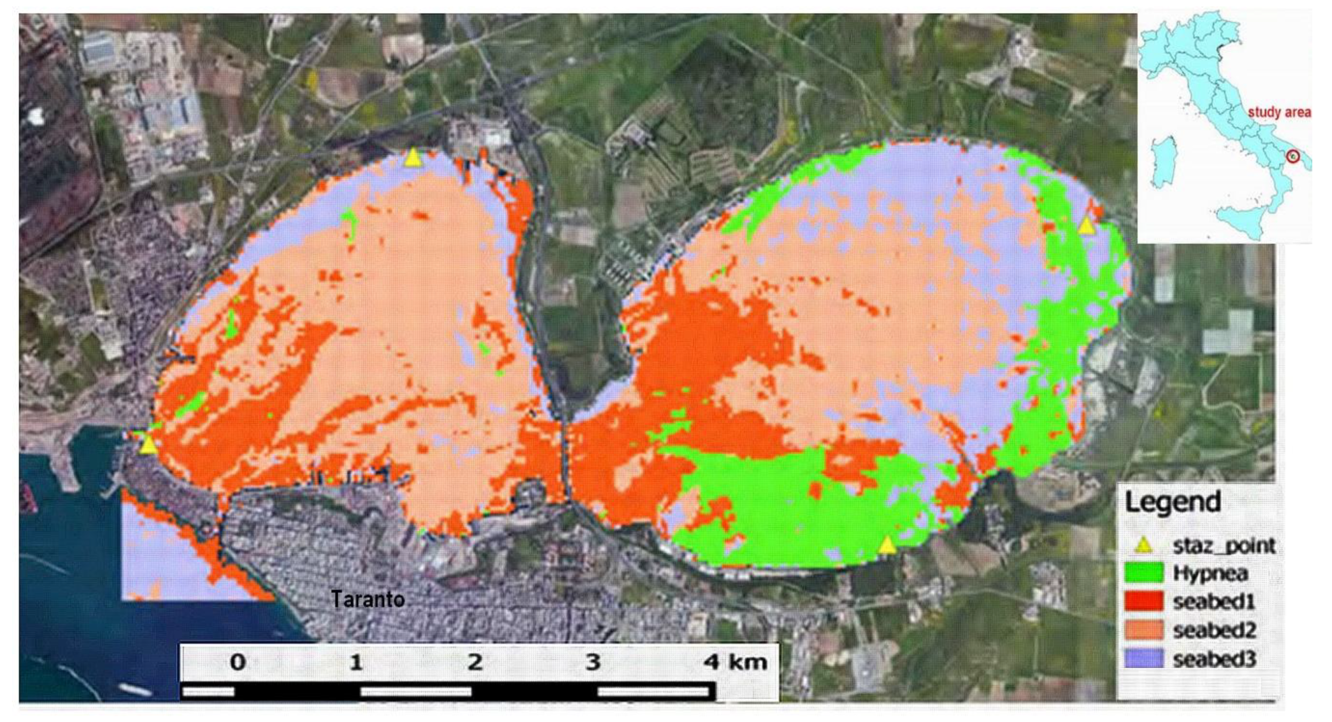
  36. Borfecchia, F.; Rubino, F.; Cibic, T.; Caroppo, C.; Cecere, E.; De Cecco, L.; Di Poi, E.; Petrocelli, A.; Pignatelli, V.; Micheli, C. Satellite mapping of macro-algae and phytoplankton communities in the Mar Piccolo of Taranto (Ionian Sea, southern Italy), a confined marine basin heavily impacted by anthropogenic activities. In Proceedings of the 20th EGU General Assembly, Vienna, Austria, 8–13 April 2018. Abstract No. EGU2018-6606-13. [Google Scholar]
  37. Gorelick, N.; Hancher, M.; Dixon, M.; Ilyushchenko, S.; Thau, D.; Moore, R. Google Earth Engine: Planetary-scale geospatial analysis for everyone. Remote Sens. Environ. 2017, 202, 18–27. [Google Scholar] [CrossRef]
  38. Micheli, C.; Cupido, R.; Lombardi, C.; Belmonte, A.; Peirano, A. Changes in genetic structure of Posidonia oceanica at Monterosso al mare (Ligurian Sea) and its resilience over a decade (1998–2009). Environ. Manag. 2012, 50, 598–606. [Google Scholar] [CrossRef] [PubMed]
  39. Micheli, C.; D’Esposito, D.; Belmonte, A.; Peirano, A.; Valiante, L.M.; Procaccini, G. Genetic diversity and structure in two protected Posidonia oceanica meadows. Mar. Environ. Res. 2015, 109, 124–131. [Google Scholar] [CrossRef]
  40. Borfecchia, F.; Consalvi, N.; Micheli, C.; Carli, F.; Cognetti De Martiis, S.; Gnisci, V.; Piermattei, V.; Belmonte, A.; De Cecco, L.; Bonamano, S.; et al. Landsat 8 OLI satellite data for mapping of the Posidonia oceanica and benthic habitats of coastal ecosystems. Int. J. Remote Sens. 2019, 39, 1–18. [Google Scholar] [CrossRef]
  41. Borfecchia, F.; Micheli, C.; Cibic, T.; Pignatelli, V.; De Cecco, L.; Consalvi, N.; Caroppo, C.; Rubino, F.; Di Poi, E.; Kralj, M.; et al. Multispectral data by the new generation of high-resolution satellite sensors for mapping phytoplankton blooms in the Mar Piccolo of Taranto (Ionian Sea, southern Italy). Eur. J. Remote Sens. 2019, 52, 400–418. [Google Scholar] [CrossRef] [Green Version]
  42. Cibic, T.; Bongiorni, L.; Borfecchia, F.; Di Leo, A.; Franzo, A.; Giandomenico, S.; Karuza, A.; Micheli, C.; Rogelja, M.; Spada, L.; et al. Ecosystem functioning approach applied to a large contaminated coastal site, the study case of the Mar Piccolo of Taranto (Ionian Sea). Environ. Sci. Pollut. Res. 2016, 23, 12739–12754. [Google Scholar] [CrossRef]
  43. Gnisci, V.; Cognetti De Martiis, S.; Belmonte, A.; Micheli, C.; Piermattei, V.; Bonamano, S.; Marcelli, M. Assessment of the ecological structure of Posidonia oceanica (L.) Delile on the northern coast of Lazio, Italy (central Tyrrhenian, Mediterranean). Ital. Bot. 2020, 9, 1–19. [Google Scholar] [CrossRef] [Green Version]
  44. Geller, G.; Halpin, P.N.; Helmuth, B.; Skidmore, A.K.; Abrams, M.; Aguirre, N.; Blair, M.; Botha, E.; Colloff, M.; Dawson, T.; et al. Remote sensing for biodiversity. In The GEO Handbook on Biodiversity Observation Networks; Walters, M., Scholes, R.J., Eds.; Springer Nature: Cham, Switzerland, 2017; pp. 19–38. [Google Scholar]
  45. Sánchez-Carnero, N.; Rodríguez-Pérez, D. Using Vertical Sidescan Sonar as a tool for seagrass cartography. Estuar. Coast. Shelf Sci. 2012, 115, 334–344. [Google Scholar] [CrossRef]
  46. Juanes, F. Visual and acoustic sensors for early detection of biological invasions: Current uses and future potential. J. Nat. Conserv. 2018, 42, 7–11. [Google Scholar] [CrossRef]
  47. Vaz, A.S.; Alcaraz-Segura, D.; Campos, J.C.; Vicente, J.R.; Honrado, J.P. Managing plant invasions through the lens of remote sensing: A review of progress and the way forward. Sci. Total Environ. 2018, 642, 1328–1339. [Google Scholar] [CrossRef]
  48. Vaz, A.S.; Gonçalves, J.F.; Pereira, P.; Santarém, F.; Vicente, J.R.; Honrado, J.P. Earth observation and social media: Evaluating the spatiotemporal contribution of non-native trees to cultural ecosystem services. Remote Sens. Environ. 2019, 230, 111193. [Google Scholar] [CrossRef]
  49. Tiralongo, F.; Lillo, A.O.; Tibullo, D.; Tondo, E.; Lo Martire, C.; D’Agnese, R.; Macali, A.; Mancini, E.; Giovos, I.; Coco, S.; et al. Monitoring uncommon and non-indigenous fishes in Italian waters: One year of results for the AlienFish project. Reg. Stud. Mar. Sci. 2019, 28, e100606. [Google Scholar] [CrossRef]
  50. Tiralongo, F.; Crocetta, F.; Riginella, E.; Lillo, A.O.; Tondo, E.; Macali, A.; Mancini, E.; Russo, F.; Coco, S.; Paolillo, G.; et al. Snapshot of rare, exotic and overlooked fish species in the Italian seas: A citizen science survey. J. Sea Res. 2020, 164, 101930. [Google Scholar] [CrossRef]
  51. Spyridopoulou, R.N.A.; Langeneck, J.; Bouziotis, D.; Giovos, I.; Kleitou, P.; Kalogirou, S. Filling the gap of data-limited fish species in the eastern Mediterranean Sea: A contribution by citizen science. J. Mar. Sci. Eng. 2020, 8, 107. [Google Scholar] [CrossRef] [Green Version]
  52. Meinesz, A.; De Vaugelas, J.; Hesse, B.; Mari, X. Spread of the introduced tropical green alga Caulerpa taxifolia in northern Mediterranean waters. J. Appl. Phycol. 1993, 5, 141–147. [Google Scholar] [CrossRef]
  53. Meinesz, A.; Belsher, T.; Thibaut, T.; Antolic, B.; Mustapha, K.B.; Boudouresque, C.F.; Chiaverini, D.; Cinelli, F.; Cottalorda, J.M.; Djellouli, A.; et al. The introduced green alga Caulerpa taxifolia continues to spread in the Mediterranean. Biol. Invasions 2001, 3, 201–210. [Google Scholar] [CrossRef]
  54. Cottalorda, J.M.; Gravez, V.; Antolić, B.; Aranda, A.; Ballesteros, E.; Boudouresque, C.F.; Cassar, N.; Cinelli, F.; Ribot, J.D.D.; Orestano, C.; et al. Second international campaign for public awareness of the Caulerpa taxifolia problem. An essential tool to collect cartographic data and to slow down the spread of this alga. In Proceedings of the Third International Workshop on Caulerpa taxifolia, Marseille, France, 19–20 September 1997; Boudouresque, C.F., Gravez, V., Meinesz, A., Palluy, F., Eds.; GIS Posidonie Publ.: Marseille, France, 1998; pp. 9–16. [Google Scholar]
  55. Mannino, A.M.; Donati, S.; Balistreri, P. The project “Caulerpa cylindracea in the Egadi Islands”: Citizens and scientists working together to monitor marine alien species. Biodivers. J. 2016, 7, 907–912. [Google Scholar]
  56. Mannino, A.M.; Cicero, F.; Toccaceli, M.; Pinna, M.; Balistreri, P. Distribution of Caulerpa taxifolia var. distichophylla (Sonder) Verlaque, Huisman & Procaccini in the Mediterranean Sea. Nat. Conserv. 2019, 37, 17–29. [Google Scholar] [CrossRef]
  57. Cerrano, C.; Milanese, M.; Ponti, M. Diving for science—Science for diving: Volunteer scuba divers support science and conservation in the Mediterranean Sea. Aquat. Conserv. Mar. Freshw. Ecosyst. 2017, 27, 303–323. [Google Scholar] [CrossRef]
  58. Ellul, T.; Evans, J.; Schembri, P.J. Invasion alert: Rapid range expansion of Caulerpa taxifolia var. distichophylla in Maltese waters (central Mediterranean). BioInvasions Rec. 2019, 8, 208–217. [Google Scholar] [CrossRef]
  59. Verlaque, M.; Ruitton, S.; Mineur, F.; Boudouresque, C.F. CIESM Atlas of Exotic Species in the Mediterranean; Macrophytes; CIESM Publishers: Monaco, 2015; Volume 4, pp. 1–364. [Google Scholar]
  60. Sghaier, Y.R.; Zakhama-Sraieb, R.; Mouelhi, S.; Vazquez, M.; Valle, C.; Ramos-Espla, A.A.; Astier, J.M.; Verlaque, M.; Charfi-Cheikhrouha, F. Review of alien marine macrophytes in Tunisia. Medit. Mar. Sci. 2016, 17, 109–123. [Google Scholar] [CrossRef] [Green Version]
  61. Holmer, M.; Marba, N.; Lamote, M.; Duarte, C.M. Deterioration of sediment quality in seagrass meadows (Posidonia oceanica) invaded by macroalgae (Caulerpa sp.). Estuar. Coast. 2009, 32, 456–466. [Google Scholar] [CrossRef] [Green Version]
  62. Meinesz, A.; Hesse, B. Introduction et invasion de l’algue tropicale Caulerpa taxifolia en Méditerranée nord-occidentale. Oceanol. Acta 1991, 14, 415–426. [Google Scholar]
  63. Boudouresque, C.F.; Bernard, G.; Pergent, G.; Shili, A.; Verlaque, M. Regression of Mediterranean seagrasses caused by natural processes and anthropogenic disturbances and stress: A critical review. Bot. Mar. 2009, 52, 395–418. [Google Scholar] [CrossRef]
  64. Verlaque, M.; Fritayre, P. Incidence de l’algue introduite Caulerpa taxifolia sur le phytobenthos de Méditerranée occidentale. 2. Les peuplements d’algues photophiles de l’infralittoral. In Proceedings of the First International workshop on Caulerpa taxifolia, Nice, France, 17–18 January 1994; Boudouresque, C.F., Meinesz, A., Gravez, V., Eds.; GIS Posidonie: Marseille, France, 1994; pp. 349–353. [Google Scholar]
  65. De Villèle, X.; Verlaque, M. Changes and degradation in a Posidonia oceanica bed invaded by the introduced tropical alga Caulerpa taxifolia in the north western Mediterranean. Bot. Mar. 1995, 38, 79–87. [Google Scholar] [CrossRef]
  66. Bitar, G.; Ramos-Esplá, A.; Ocaña, O.; Sghaier, Y.; Forcada, A.; Valle, C.; El Shaer, H.; Verlaque, M. Introduced marine macroflora of Lebanon and its distribution on the Levantine coast. Mediterr. Mar. Sci. 2017, 18, 138–155. [Google Scholar] [CrossRef] [Green Version]
  67. Musco, L.; Andaloro, F.; Mikac, B.; Mirto, S.; Vega Fernandez, T.; Badalamenti, F. Concern about the spread of the invader seaweed Caulerpa taxifolia var. distichophylla (Chlorophyta: Caulerpales) to the Western Mediterranean. Mediterr. Mar. Sci. 2014, 15, 532–538. [Google Scholar] [CrossRef] [Green Version]
  68. Musco, L.; Andaloro, F.; D’Anna, G.; Giangrande, A.; Lo Brutto, S.; Mikac, B.; Mirto, S.; Pipitone, C.; Scuderi, D.; Vega Fernández, T.; et al. Impatto di Caulerpa taxifolia var. distichophylla su macro- e meio-fauna associate a Posidonia oceanica. Biol. Mar. Medit. 2015, 22, 136–137. [Google Scholar]
  69. Picciotto, M.; Bertuccio, C.; Giacobbe, S.; Spanò, N. Caulerpa taxifolia var. distichophylla: A further stepping stone in the western Mediterranean. Mar. Biodivers. Rec. 2016, 9, 73. [Google Scholar] [CrossRef] [Green Version]
  70. Mannino, A.M.; Balistreri, P. An updated overview of invasive Caulerpa taxa in Sicily and circum-Sicilian Islands, strategic zones within the NW Mediterranean Sea. Flora Mediterr. 2017, 27, 221–240. [Google Scholar] [CrossRef]
  71. Carlton, J.T. Biological invasions and cryptogenic species. Ecology 1996, 7, 1653–1655. [Google Scholar] [CrossRef]
  72. Petrocelli, A.; Cecere, E.; Portacci, G.; Micheli, C.; De Cecco, L.; Martini, S.; Borfecchia, F. Preliminary mapping of the alien seaweed Hypnea cornuta (Rhodophyta, Gigartinales) in the Mar Piccolo of Taranto (Southern Italy, Mediterranean Sea). Biol. Mar. Medit. 2015, 22, 44–45. [Google Scholar]
  73. Reinbold, T. Meeresalgen von der Insel Rhodos. Hedwigia 1898, 37, 87–90. [Google Scholar]
  74. Theriault, C.; Scheibling, R.; Hatcher, B.; Jones, W. Mapping the distribution of an invasive marine alga (Codium fragile spp. tomentosoides) in optically shallow coastal waters using the compact airborne spectrographic imager (CASI). Can. J. Remote Sens. 2006, 32, 315–329. [Google Scholar] [CrossRef]
  75. Ody, A.; Thibaut, T.; Berline, L.; Changeux, T.; André, J.M.; Chevalier, C.; Blanfuné, A.; Blanchot, J.; Ruitton, S.; Stiger-Pouvreau, V.; et al. From in situ to satellite observations of pelagic Sargassum distribution and aggregation in the Tropical North Atlantic Ocean. PLoS ONE 2019, 14, e0222584. [Google Scholar] [CrossRef] [Green Version]
  76. Meinesz, A. Methods for identifying and tracking seaweed invasions. Bot. Mar. 2007, 50, 373–384. [Google Scholar] [CrossRef]
  77. Verlaque, M.; Breton, G. Biological invasion: Long term monitoring of the macroalgal flora of a major European harbor complex. Mar. Pollut. Bull. 2019, 43, 228–241. [Google Scholar] [CrossRef]
  78. Banha, F.; Veríssimo, A.; Ribeiro, F.; Anastácio, P.M. Forensic reconstruction of Ictalurus punctatus invasion routes using on-line fishermen records. Knowl. Manag. Aquat. Ecosyst. 2017, 418, 56. [Google Scholar] [CrossRef] [Green Version]
  79. Giovos, I.; Kleitou, P.; Paravas, P.; Marmara, D.; Romanidis-Kyriakidis, G.; Poursanidis, D. Citizen scientists monitoring the establishment and expansion of Pterois miles (Bennett, 1828) in the Aegean Sea. Greece. Cah. Biol. Mar. 2018, 59, 359–365. [Google Scholar] [CrossRef]
  80. Azzurro, E.; Tiralongo, F. First record of the mottled spine foot Siganus fuscescens (Houttuyn, 1782) in the Mediterranean waters: A Facebook based detection. Mediterr. Mar. Sci. 2020, 21, 448–451. [Google Scholar] [CrossRef]
  81. Cardoso, A.; Tsiamis, K.; Gervasini, E.; Schade, S.; Taucer, F.; Adriaens, T.; Copas, K.; Flevaris, S.; Galiay, P.; Jennings, E.; et al. Citizen science and open data: A model for invasive alien species in Europe. Res. Ideas Outcomes 2017, 3, e14811. [Google Scholar] [CrossRef] [Green Version]
  82. Deriu, I.; D’Amico, F.; Tsiamis, K.; Gervasini, E.; Cardoso, A.C. Handling big data of alien species in Europe: The European alien species information network geodatabase. Front. ICT 2017, 4, 20. [Google Scholar] [CrossRef] [Green Version]
  83. Langeneck, J.; Marcelli, M.; Bariche, M.; Azzurro, E. Social networks allow early detection of nonindigenous species: First record of the red drum Sciaenops ocellatus (Actinopterygii: Perciformes: Sciaenidae) in Italian waters. Acta Adriat. 2017, 58, 365–370. [Google Scholar] [CrossRef]
  84. Bargnesi, F.; Lucrezi, S.; Ferretti, F. Opportunities from citizen science for shark conservation, with a focus on the Mediterranean Sea. Eur. Zool. J. 2020, 87, 20–34. [Google Scholar] [CrossRef] [Green Version]
  85. Zenetos, A.; Koutsogiannopoulos, D.; Ovalis, P.; Poursanidis, D. The role played by citizen scientists in monitoring marine alien species in Greece. Cah. Biol. Mar. 2013, 54, 419–426. [Google Scholar]
  86. Redpath, S.M.; Young, J.; Evely, A.; Adams, W.M.; Sutherland, W.J.; Whitehouse, A.; Amar, A.; Lambert, R.A.; Linnell, J.D.C.; Watt, A.; et al. Understanding and managing conservation conflicts. Trends Ecol. Evol. 2013, 28, 100–109. [Google Scholar] [CrossRef] [PubMed]
  87. Ruiz-Frau, A.; Hinz, H.; Edwards-Jones, G.; Kaiser, M.J. Spatially explicit economic assessment of cultural ecosystem services: Non-extractive recreational uses of the coastal environment related to marine biodiversity. Mar. Policy 2013, 38, 90–98. [Google Scholar] [CrossRef]
  88. Popescu, V.D.; Rozylowicz, L.; Niculae, I.M.; Cucu, A.L.; Hartel, T. Species, habitats, society: An evaluation of research supporting EU’s Natura 2000 network. PLoS ONE 2014, 9, e113648. [Google Scholar] [CrossRef] [Green Version]
  89. Katsanevakis, S.; Deriu, I.; D’Amico, F.; Nunes, A.L.; Pelaez Sanchez, S.; Crocetta, F.; Arianoutsou, M.; Bazos, I.; Christopoulou, A.; Curto, G.; et al. European Alien Species Information Network (EASIN): Supporting European policies and scientific research. Manag. Biol. Invasions 2015, 6, 147–157. [Google Scholar] [CrossRef] [Green Version]
  90. Lisón, F.; Altamirano, A.; Field, R.; Jones, G. Conservation on the blink: Deficient technical reports threaten conservation in the Natura 2000 network. Biol. Conserv. 2017, 209, 11–16. [Google Scholar] [CrossRef] [Green Version]
  91. Mačić, V.; Albano, P.G.; Almpanidou, V.; Claudet, J.; Corrales, X.; Essl, F.; Evagelopoulos, A.; Giovos, I.; Jimenez, C.; Kark, S.; et al. Biological invasions in conservation planning: A global systematic review. Front. Mar. Sci. 2018, 5, 178. [Google Scholar] [CrossRef] [Green Version]
  92. Coll, M.; Piroddi, C.; Steenbeek, J.; Kaschner, K.; Ben RaisLasram, F.; Aguzzi, J.; Ballesteros, E. The biodiversity of the Mediterranean Sea: Estimates, patterns and threats. PLoS ONE 2010, 5, e11842. [Google Scholar] [CrossRef] [Green Version]
  93. Hu, Z.; Yang, Z.; Salakhutdinov, R.; Xing, E.P. Deep neural networks with massive learned knowledge. In Proceedings of the 2016 Conference on Empirical Methods in Natural Language Processing, Austin, TX, USA, 1–5 November 2016; Association for Computational Linguistics: Stroudsburg, PA, USA, 2016; pp. 1670–1679. [Google Scholar]
  94. Wang, M.; Hu, C. Mapping and quantifying Sargassum distribution and coverage in the Central West Atlantic using MODIS observations. Remote Sens. Environ. 2016, 183, 350–367. [Google Scholar] [CrossRef]
  95. Hein, G.W. Status, perspectives and trends of satellite navigation. Satell. Navig. 2020, 1, 22. [Google Scholar] [CrossRef]
  96. Reid, T.G.R.; Neish, A.M.; Walter, T.; Enge, P.K. Broadband LEO constellations for navigation. Navig. J. Inst. Navig. 2018, 65, 205–220. [Google Scholar] [CrossRef]
  97. Danielsen, F.; Burgess, N.D.; Balmford, A. Monitoring matters: Examining the potential of locally-based approaches. Biodivers. Conserv. 2005, 14, 2507–2542. [Google Scholar] [CrossRef]
  98. Gallo, T.; Waitt, D. Creating a successful citizen science model to detect and report invasive species. BioScience 2011, 61, 459–465. [Google Scholar] [CrossRef] [Green Version]
Figure 1. Caulerpa cylindracea with macroalgae and sponges (Secca del Toro—Favignana, 15 m depth; photo by Sergio Zanoni; from Reference [70]) (A). Caulerpa taxifolia in a Posidonia oceanica meadow (Strait of Messina, 12 m depth; photo by Alessandro Pagano; from Reference [70]) (B). Small patches of Caulerpa taxifolia var. distichophylla at Termini Imerese (photo by Marco Toccaceli; from Reference [56]) (C).
Jmse 09 00288 g001
Figure 2. Occurrences of Caulerpa cylindracea within the Egadi Islands marine protected area (MPA) (modified from Reference [55]).
Jmse 09 00288 g002
Figure 3. Thematic map of Hypnea cornuta from Landsat 8 Operational Land Imager (OLI) data acquired on August 2014 (from Reference [72]).
Jmse 09 00288 g003
Publisher’s Note: MDPI stays neutral with regard to jurisdictional claims in published maps and institutional affiliations.

