
Towards Better Valorisation of Industrial Minerals and Rocks in Serbia—Case Study of Industrial Clays


Faculty of Mining and Geology, University of Belgrade, Djusina 7, 11000 Belgrade, Serbia
*
Author to whom correspondence should be addressed.
Resources 2021, 10(6), 63; https://0-doi-org.brum.beds.ac.uk/10.3390/resources10060063
Submission received: 6 May 2021
/
Revised: 9 June 2021
/
Accepted: 10 June 2021
/
Published: 17 June 2021
(This article belongs to the Special Issue Mineral Deposit Safeguarding in the EU)
Abstract
:The improvement in valorisation of industrial minerals and rocks in Serbia is related to improvement of legislation, and to adoption of best possible techniques for geological exploration and estimation of resources/reserves. Therefore, we analyzed the actual practice in the field of geological exploration which has not changed significantly in the last 30 years, as well as legislation related to the mining industry and access to land. The improvement of legislation mostly depends on the state authorities. Contrary to that, the enhancement of geological exploration methodology should be the issue of experts working in that area of the mining industry but is also very much related to the existing legislation. Serbia still has very strictly prescribed procedures, which are generally good; however, it is an overly complicated and restrictive system for performing geological exploration and evaluation of mineral deposits. The most important improvements in legislation in the last twenty years are presented and discussed, as well as problems that still need to be solved and solutions found to fully understand the potential of industrial minerals and rocks in Serbia.
1. Introduction
The Republic of Serbia, as well as the whole of Eastern and Southeastern Europe, has undergone great changes in the political, societal, and economic fields in the last thirty years. The changes did not significantly affect the field of geological exploration and evaluation of mineral resources/reserves and their classification, which is still causing some inconveniences, especially for the mineral industry sector. The best possible valorisation of mineral resources, particularly of industrial minerals and rocks (IMR), depends on several important issues that can be formal (legislative in the field of mining, and access to land) and technical/scientific (geological exploration and evaluation of a mineral deposit).
The regulatory framework in Serbia is based on the Law on Mining and Geological Exploration from 2015 [1] and environmental law from 2004 [2]. General rules have not been changed substantially from the previous regulations [3,4], so the most important issues are summarized here.
Within the EU, and all other countries including Serbia, some of the main preconditions for valorisation of mineral resources (commodities) are mineral ownership and permitting regimes [5]. Mineral ownership is an important aspect for permitting because permitting procedures are usually different for state-owned/state-controlled minerals and for land owned. Likewise, the mineral resource permitting regimes may be centralized, decentralized or mixed [5]. All mineral commodities in Serbia are public property of the state. Geological exploration in Serbia is formally divided into basic geological exploration (financed by the state and performed by the Geological Survey of Serbia) and applied geological exploration, financed by private companies. Geological exploration and mining are under jurisdiction of the Ministry of Mining and Energy and the mineral resources permitting regime is a mixed one, although predominantly based on a one-stop-shop, as most permits are issued by the same Ministry. The approvals and permits are issued by the Ministry of Mining and Energy, while all approvals and permits for the territory of the Autonomous region of Vojvodina are issued by the Regional Secretariat for Energy and Mineral Resources. In each case, the necessary documents are the same.
Serbia has no standard concession system for exploration and/or exploitation of mineral resources unless the government decides to launch a tender or auction for some specific projects or area(s). Otherwise, a ‘first come, first served’ system is applied, which means that any interested investor may apply for the permit if the location is free. The mining legislation covers the whole life cycle: prospection, exploration, exploitation, processing, closure, environmental rehabilitation, and post-closure activities.
Similar exploration and reporting systems are still used in former Yugoslav countries [6,7,8,9,10,11,12,13,14]. In Eastern Europe there are national codes for reporting, which may be CRIRSCO-based (Poland, Romania and Estonia), Soviet-based (Bulgaria, Lithuania and Latvia), and predominantly Soviet-based, but with some specific rules (Czech Republic, Slovakia, Hungary), as summarized by [15]. The interesting European and worldwide experience in exploration and evaluation of industrial clays was published in several articles [16,17,18,19,20,21,22,23,24,25].
The objective of this article was to analyze the factors influencing the large impact of complicated exploration and evaluation systems on better valorisation of industrial mineral and rocks in Serbia, based on resource studies of industrial clays obtained in Serbia in the last 60 years. The differences in the approach to the problem of reporting (classification and categorization of reserves/resources) and the degree of geological exploration level will be presented here, as well as the relationship in practice between Serbian reserve categories and categories according to the JORC or similar classifications [26,27,28,29,30].
2. Materials & Methods
The analysis and assessment of current situation in the mining industry in Serbia, presented in this paper, deals with some of the important factors that influence better valorisation of IMR. Those factors include the existing regulatory framework in Serbia, access to land necessary for exploration/exploitation, current practise related to geological exploration including testing procedures and analyses, and actual standards for reporting of exploration results, mineral resources, and ore reserves in Serbia.
The industrial clays were chosen as an example in this article as they exhibit important relationship between the origin of clays and their quality and morphology of deposits, and quite a large database of unpublished reports. In this analysis we were using results from numerous geological reports on different industrial clays that were prepared in the last 60 years. It included a couple of hundred reports on refractory and ceramic clays, bentonites, and common clays that were available in the funds of geological institutes that existed in the previous period.
The database that we checked and analyzed also included a large number of papers published in the Serbian language, and the most important sources of information were numerous papers and studies in which geology, mineralogy and origin of different industrial clays were studied [31,32,33,34,35,36,37,38,39,40].
Our assessment and analysis included four issues:
- The first issue was related to existing mining legislation, improvements that were performed in the last ten years, and the issues that need to be modernized.
- The second issue represents existing practice in geological exploration of IMR presented as an example of industrial clays and the influences of regulations on that process.
- The third issue is focused on spatial planning related to the mining sector.
- The fourth issue concentrates on the standard for reporting exploration results, resources and reserves in Serbia compared to CRIRSCO derived standards, with examples of some problems that occur occasionally in practice.
3. Results
3.1. Industrial Clays in Serbia
Clays are one of the basic non-metallic mineral raw materials, both in modern industry and in the entire history of the development of civilization. In terms of production volume and economic significance, they can be compared to stone and carbonate raw materials only. The industrial clays include kaolins, bentonites, palygorskite-sepiolite, and common clays [41,42]. On the other hand, four categories of industrial clay can be distinguished based on their quality, rarity, investments necessary to start operations and the markets they need to supply [19]. In Serbia, as in most parts of Eastern and Southeastern Europe, “in situ” kaolin deposits are differentiated from refractory and ceramic clay deposits which were formed by erosion and redeposition of the material from the weathering crusts [43]; thus, refractory and ceramic clays as an industrial category of clays will be used as well. As in Serbia there are neither properly explored palygorskite-sepiolite deposits, nor prescriptions for their exploration, that commodity will not be discussed.
3.1.1. Kaolin
Primary kaolin deposits can be classified according to their genesis as weathering, hydrothermal and mixed-hydrothermal with subsequent weathering [44]. The economic importance of all hydrothermal kaolin deposits in Serbia is small due to small deposits/ore bodies, and usually complicated morphology of deposits [45].
The most important kaolin deposits originated by weathering of granitic rocks [45] and are predominantly of blanket type, covering occasionally large area and containing huge tonnage of kaolin, as in the case of Garaši deposit near Aranđelovac [46]. All weathering kaolin deposits in Serbia are of alkaline type, being an interesting source of washed kaolin, feldspar, quartz, and muscovite. The principal clay mineral is kaolinite, accompanied by small amounts of illite and, rarely, smectite. As this type of kaolin deposit was not subjected to strong kaolinisation, the iron content is relatively high compared to typical kaolin deposits in large world producing areas (UK, USA, Brasil, etc.) [19].
3.1.2. Refractory and Ceramic Clays
Sedimentary deposits of refractory and ceramic clays in Serbia occur in Neogene sediments mainly along the southern border of the Pannonian basin, and in the Lower Jurassic sediments of East Serbia [47,48,49,50]. From Table 1 it is obvious that clays derived from different host rocks have specific mineral compositions which, together with the content of iron and organic substances, define their mode of utilisation.
Refractory clays with high kaolinite content originate from weathering of granitic and dacite-andesitic rocks. Typical ceramic (non-refractory) clays, made of kaolinite with considerable amounts of illite and, occasionally, interstratified illite-smectite and smectite, were derived from sericite-chlorite schist, mica schist and metaclastic rocks.
3.1.3. Common Clays
The term “common clays” is used by the US Geological Survey and the Society for Mining, Metallurgy, and Exploration for clays, shales, soil clays, and glacial clays that are used primarily for structural clay products [42]. Common clays in Serbia include clays (from sedimentological point of view), and all mineral raw materials used in the clay-based structural products (ceramics), such as loess, oil shales, separation tailings rich in organic matter, products obtained by washing of coal and other natural raw materials. The territory of Serbia is very rich in common clays of different mineral composition and quality, largely dependent on their origin, i.e., depositional conditions of a sedimentary basin (Table 2).
In Serbian practice, differences in mineral and granulometric composition of a common clay and the final products that are produced do not influence much the exploration process as rules are the same for all applications of common clays. It means that competent a person can prepare an excellent exploration scheme, but due to restrictions in the Rulebook [52], it will cost much more than the “standard” one based just on rules and is, therefore, not competitive on the market.
3.1.4. Bentonites
The resources of bentonite are, after more than forty years of exploration, very large (at least according to the reserves that exist on paper), but the economic effects of that exploration are almost non-existent. Resources of bentonite and bentonitic clays of tens of millions of tonnes have been calculated (according to the Serbian standard those are reserves of A + B + C1 categories), but continuous exploitation of bentonite in Serbia never existed. The main problems of valorisation of most bentonite deposits are relatively small deposits with layers of bentonite of small thickness, mostly medium or poor quality of raw materials, and underground method of exploitation (Table 3). In addition, high transport costs prevent potential exports, and domestic utilisation is impossible without bentonite processing plants and related industry that would use the final products. All these facts impose the necessity of a detailed and complex study of bentonite deposits, and above all a critical analysis and evaluation of both the current exploration methodology and the achieved results.
3.2. Actual Geological Exploration of Industrial Clays in Serbia
Actual geological exploration and reporting standards in Serbia are still a derivation of the older, non-CRIRSCO-aligned Soviet state system. The example of clay rocks is used to presents the obvious professional shortcomings of the Serbian Rulebook [52] and the practice in clay exploration. The concept of the Rulebook is based on the classification of mineral reserves of the former Soviet Union from the 1960s, but with many peculiar additions and specifics. In all the above classifications, the basis for the categorisation of reserves is the maximum distances between exploration works and the maximum length of sampling interval. Table 4 and Table 5 show the recommended distances from the basic classification of clay rock reserves of the USSR from 1961 [54], which remained unchanged in the classification of the Russian Federation from 2007 [55], and the maximum allowed distances from all presented examples from the Serbian Rulebook.
The presented and described exploration procedure can be summarized as follows:
- The recommended distances between exploration works for clay deposits (Table 4) represent for that time, but still today, the most rational basic concept for exploration of clay rock deposits, regardless of the area of application.
- In the Serbian Rulebook [52] on the exploration of kaolin deposits (Table 5), the distances for groups 1 and 2 for categories A, B and C1 are very strange, and it is not clear based on which they are defined, and they amount to 50–90–200 and 40–70–150 m, respectively. It would be geologically logical for the corresponding distances to be 100–200–400 and 50–100–200, respectively. It would also be logical, if such detailing is done, to separate the kaolin deposits of the blanket-type of weathering crust from the hydrothermal ones and the linear-type weathering crust deposits, because it is known that their morphology and quality are quite different.
- For refractory and ceramic clays (Table 5) the given distances are in accordance with the Soviet source and can be recommended as optimal for our conditions.
- In the case of common clay deposits (Table 5), the given distances are identical to those prescribed for refractory and ceramic clays. This is not rational if it is known that ceramic and refractory clays everywhere in the world represent a far more valuable raw material than brick clays. The recommended distances between boreholes for brick clays should be at least 50% longer than the existing ones. In the case of brick clays, scientifically and professionally observed, clays to produce tiles and facade bricks, clays to produce hollow building elements and clays for the production of solid bricks should be separated. Namely, there is a significant difference in the requirements for the quality of raw materials to produce these assortments of construction ceramics, which had to be reflected in the practice during exploration. An indicative example of irrational spending of financial resources is for tests on individual samples of brick clays, when it occurs that 80% of the results are marked “the same”.
- In the case of bentonite clay deposits (Table 5), there is a very interesting situation in that someone who plans to explore bentonite deposits in sedimentary basins, where bentonite is generally found at a considerable depth [53], should assume that the part of the basin explored will have less or more than 600,000 tons, and whether the individual blocks in the event of a fault will have less than 50,000 tons or even less than 10,000 tons. From the Rulebook it is also not clear to which reserves it applies—resources or reserves in the CRIRSCO-based system.
When we consider the problem of determining the optimal testing network and the length of individual testing intervals, we again encounter the formalism in the Rulebook, which completely indiscriminately (depending on the morphogenetic shape of the deposit and raw material quality) defines an almost uniform testing methodology, leaving the responsible designers without the opportunity to apply their knowledge and experience on a particular deposit, type of raw material or even a certain quality (grade) of raw material.
4. Discussion
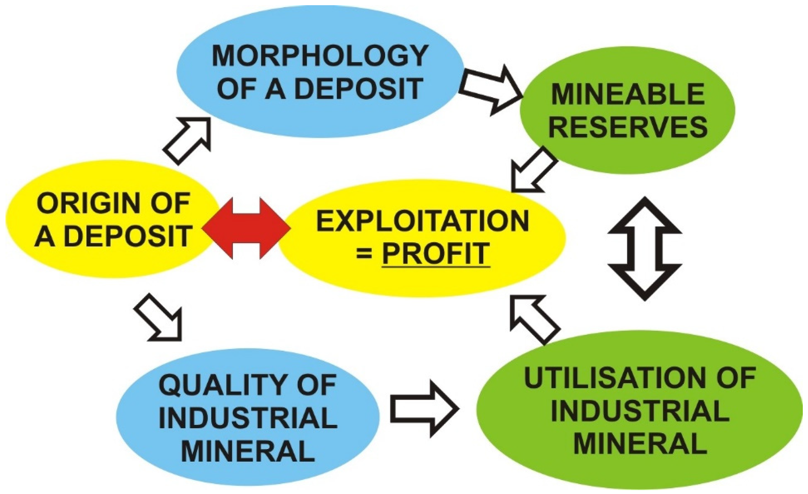
The best possible valorisation of IMR and particularly industrial clays is an interplay between scientific work reflected in determination of a genetic type of a mineral deposit based on procedures necessary to perform the best available exploration project resulting in good knowledge of the deposit morphology, quality/grade of mineral commodity, and optimal utilisation (Figure 1). The next step is adequate evaluation and estimation of resources/reserves that ultimately leads to exploitation and profit.
The most important issues affecting the best possible valorisation of IMR that will be discussed can be summarized as follows:
- Legislation in the field of mineral resources’ exploration, exploitation, and spatial planning still needs to be completely innovated.
- Reporting standard is not compatible with CRIRSCO.
The scientific approach to geological exploration is constrained by the fact that practically no exploration of IMR on the state level exists, as basic geological explorations, being insufficiently profitable, are inevitably neglected. This is reflected in the relatively low exploration level of certain sedimentary basins, especially insufficient knowledge on the metallogenetic factors influencing the occurrence of certain types of industrial minerals and especially insufficient knowledge on the origin and occurrences of certain types of industrial clays. Better valorisation of IMR including industrial clays is additionally complicated by the underdeveloped market due to recession in Serbian and surrounding economies and industries, and high transport costs in case of possible export of IMR.
4.1. Permitting in Serbia
4.1.1. Mining Sector
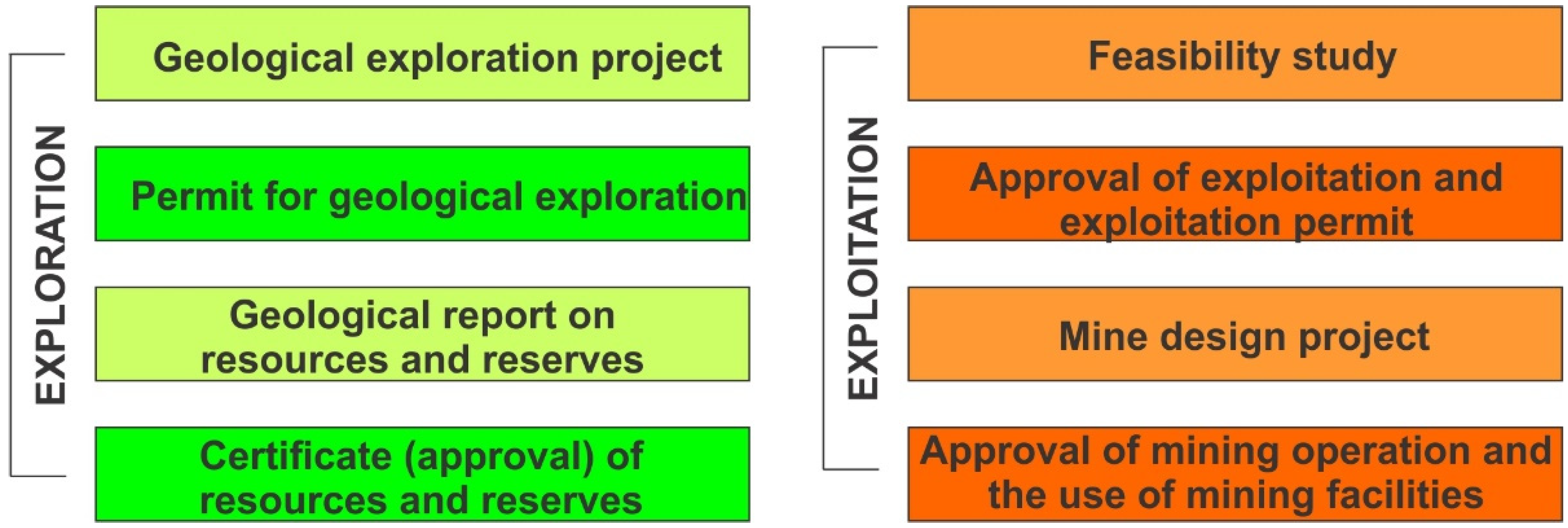
The general procedure for exploration and exploitation of the new mine/quarry is divided in four steps: geological exploration, approval of exploitation, approval of execution of mining operations, and approval for the use of mining facilities (Figure 2).
Some changes in the mining legislation in the last ten years were very good, i.e., the possibility to extend the exploration period for metallic ores, and definition of strategic mineral commodities [1,56]. Another important improvement in legislation is the establishing of the protective zone around the exploitation field in which exploitation is not planned or performed now but represents a space that separates exploitation fields and allows, at one point in time, the holder of the exploitation permit for the same area to request an exploration permit if there are indications that mineral resources are located outside the existing boundaries of the exploitation field [56]. The protective zone around the exploitation field required for the possible expansion of reserves and resources is defined in the exploitation permit and may be as follows: for exploitation fields of up to 25, 25–100, and over 100 ha, protective area width is up to 100, 250, and 500 m, respectively.
What is missing in legislation [1] is that prospection is included in the timeframe for geological exploration, which is for industrial clays two years plus possible extension for another year, and in most cases, it is quite enough. However, the area for geological exploration is limited to a maximum of two square kilometres, which is often not enough for new potential targets, and requires investors to submit several exploration projects in the same area for the same mineral commodity. It would be good to have the possibility to quickly explore, in twelve months, a larger area with several drillholes and then reduce the exploration permit to maximum 2 km2.
Legal timeframes for authorities to decide on exploration permit applications is generally for IMR between five and seven months. The average timeframe to perform a geological exploration project and prepare the geological report is around one year, depending on the size of the deposit and the exploration level. Legal timeframes for authorities to decide on mining permit applications is 3–4 months if the Environmental Impact Study is not necessary, or 9–12 months if it is mandatory. The Environmental Impact Study is mandatory for deposits larger than 10 hectares, while for the smaller deposits the Ministry of Environmental Protection decides whether it is necessary to perform it or not. All data on exploration and exploitation licences are available online [57,58].
4.1.2. Spatial Planning Related to Mining Industry
Spatial planning is an effective regulatory tool which can bridge the usual difficulties in land-use competition and find common ground between different interests and facilitate permitting procedures as based on several examples such as the Austrian Mineral Resources Plan [59] and mining-geological studies in Croatia [60]. The importance of a well prepared and performed geological exploration programme for sustainable planning in future valorisation of mineral commodities in Serbia, particularly aggregates, has been recently emphasized [61]. Recent study of the relationship between spatial planning and mining in EU and UK [5] presented examples of close coordination between land use planning and mineral planning (for instance Austria, Belgium, Croatia, Denmark, Italy, Germany, Lithuania, Poland, Slovenia, and the United Kingdom), but also some cases where spatial planning practices have created considerable delays during permitting procedures. One of the reasons is that to start mineral extraction the planned project needs to be located either within an area designated as an “extraction zone” or within a spatial plan. As the change of land use planning from non-mining into mining is one of the major bottlenecks in mineral resource permitting in Europe, it was estimated that across the EU it takes on average 10 years to finalize this process [62].
Spatial planning in Serbia is regulated by the Law on Planning and Construction [63] and includes three levels: national, regional, and municipal. The most important for the mining sector is the municipal level of spatial planning. The spatial planning in Serbia related to mining is relatively simple and fast compared to the average in the EU [5]. To obtain the exploration permit it is mandatory to have approval from the Institution in charge of nature protection and the Institution in charge of protection of cultural monuments [1]. Although it is not mandatory in the Law on Mining and geological exploration [1], even at the stage of application for geological exploration, companies usually ask for conditions and restrictions (if any) from local authorities at the municipal level to avoid potential problems in the future. Sometimes the municipal authorities may ask for a detailed regulation plan, particularly if the exploration target is close to some category of protected area or vulnerable area (water courses and vicinity of populated areas). The total procedure to obtain all permits related to exploration is usually 1–6 months depending on required data. All data on protected areas are available online [64].
For the land use changes necessary for exploitation of a mineral deposit two mandatory documents—approval of reserves and reclamation/recultivation project—must be submitted to the ministry in charge of agriculture, forestry, and water management. After the approval from the Ministry, necessary changes are made at the municipal level.
Summarising the actual land use change procedures to get the exploitation permit, we can say that it is good, as only protected areas and some exclusion zones related to existing settlement areas are not available for exploration and, potentially, for further exploitation. The industrial clays in that context are a good example as it is not easy to predict the exact areas where you can expect commercial deposits, particularly when considering common clay deposits.
4.2. Reporting Standard in Serbia
Historically, in the last 60–70 years there were generally two systems/standards for reporting of exploration results, mineral resources, and ore reserves: the former Soviet one based on Soviet Union State Commission on Reserves instructions [54], which were well developed and widely used in the former East and Southeast Europe; and the other systems widely used by industry and supported by financial institutions, based on measured, indicated and inferred resources and proven, probable and possible reserves, later resulting in different CRIRSCO family members and UNFC reporting systems.
Governmental systems/standards for reporting of exploration results, mineral resources and ore reserves in Serbia have not been changed significantly in practice in the last 60 years, although in the Law on Mining and Geological Explorations from 2011 [56], a mandatory standard for reporting of exploration results, mineral resources, and ore reserves that must be prepared by competent people was introduced. The Law on Mining and Geological Explorations from 2015 in article 51 also confirmed that classification of mineral resources and reserves shall be made in accordance with the adequate regulations and rulebooks concerning the reporting and classification of solid mineral resources harmonized with the recognized international methods of reporting and classification. However, the necessary regulations and rulebooks have not been prepared yet.
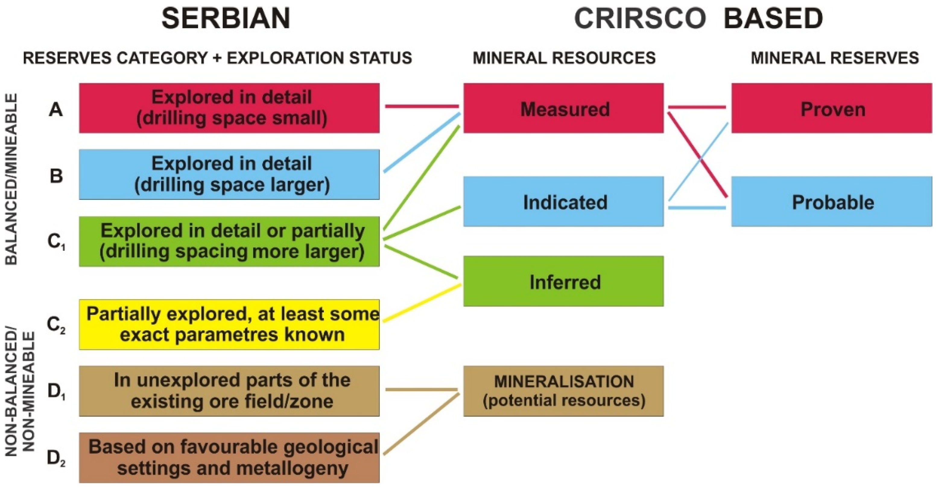
Serbia is, therefore, one of several Central and Eastern European countries where a derivation of the older, non-CRIRSCO-aligned Soviet state system is used. There is always a question about how to compare the exploration results in such cases and there were several proposals about how to do this directly, or “automatically” [65,66,67]. The comparison between Serbian reserves according to the still valid legislation and the CRIRSCO based reporting system is presented in Table 6. In the Serbian classification, as in the whole former Yugoslavia, Soviet and Russian category P is named category D. Serbian reserve categories A, B and C1 may correlate either with measured and indicated resources if the analysis of modifying factors was not performed or is negative, or may correlate to mineral reserves if feasibility study is positive.
Almost 60 years ago, the Russian school provided a simple classification of deposits by groups, without unnecessary details. According to the authors of this paper, the absolute advantage of that source [54] are recommended, not strictly prescribed and mandatory exploration methods, distances between boreholes, number of samples or sampling intervals. Namely, the original text explicitly states that “the distances shown between the exploration works are not mandatory and must not in any way limit the initiative of geologists in choosing the most rational exploration network.”
The excellent example of kaolinite clay exploration procedure in the United States is shown in Table 7. The exploration level of those deposits is very high, although in the USA a CRIRSCO derived reporting system (The SME guide for reporting exploration results, mineral resources, and mineral reserves) is used [68] which leaves the exploration procedures to Competent or Qualified persons and is based on long-term experience of USA exploration geologists and demand of clay producers and consumers.
According to the JORC classification [26], the categories of resources or reserves are also defined according to the degree of geological exploration of deposits and knowledge of mining, technological, economic, and other modifying factors. However, according to the recommendations of the JORC, the classifications of distances between investigative works are not prescribed, as well as analytical methods, nor the minimum number of required tests/analyses. This was done intentionally, because it encourages intellectual work and development in the field of geological exploration, mining, and geostatistical analysis. The JORC classification also highlights the importance and experience of the “Competent Person”, who is only authorized to sign a publicly available geological report, which must also be certified by an independent competent person.
The exploration procedure shall be improved by using more adequate analytical methods and a different approach based on the type of industrial clay in a particular deposit. Many of the manuals and papers in Russian [70,71] address the issue of testing clay deposits and emphasize the need to adapt testing methods and analyses to specific types of raw materials and deposits. Novel studies on the assessment of industrial clays give improved testing procedures and analytical techniques [21] as well as new perspectives of exploration and utilisation [16,17,18,22,72]. Geology, mineralogy, and origin of industrial clays present data on recently explored mineral deposits [73,74]. Current fundamental and applied investigation of clay minerals in China was summarized by [23] and for Central Europe by [24].
A proposal to correlate Serbian classification of reserves with the CRIRSCO-based, UN, and Russian Federation classifications was presented by [75], which is basically correct and applicable. However, we believe that only the resources should be divided into C2 category on the one hand, and D category resources on the other hand, given the big difference in the degree of reliability of the source data.
However, the situation with reserve equivalence in practice is often very volatile. Based on previous personal experience (classification of reserves/resources according to JORC for the Stanari coal deposit, Bosnia and Herzegovina), the porphyry copper deposit Borska Reka in Serbia, as well as several limestone deposits, which were accepted by international experts, we believe that the equivalence of reserves must be done from deposit to deposit, especially for the more important ones, with complicated geological structure, tectonics and strict technological requirements for certain grades of raw materials. In the case of geologically relatively simple deposits (aggregate rocks, raw materials for structural ceramics), equivalence can also be done automatically according to the model proposed by [75]. Figure 3 shows the usual, but also some possible combinations when evaluating the classification and categorization of reserves/resources between Serbian and CRIRSCO-based classifications.
As D1 and D2 Serbian reserves are in fact mineralisation, it will not be discussed further. Occasionally, problems with correlation started with C2 reserves, i.e., inferred resources. In Serbia, C2 category is usually not supported by exploration results as that category of reserves cannot be exploited. Therefore, their estimation is mostly based on extrapolation of C1 category of reserves and occasionally included in the geological report. In most cases, when IMR are explored this is sufficient to express those reserves as inferred resources, particularly in relatively homogeneous sedimentary environments and well exposed mineral deposits. However, in some cases formal correlation between Serbian C2 category of reserves can lead to important oversizing of a potential mineral deposit if the reserves were estimated based on surface geology alone.
The Serbian C1 category can be a nightmare in some cases for experts not familiar with Serbian practice in this field. Namely, until 2006 [76] this category was not exploitable, as it was mandatory to increase the exploration level at least to the B category. It is always important to keep in mind that in general, the exploration level of B category is 4 times less than A category, and in the case of C1 category the exploration level is 16 times lower compared to A category (based on the usual maximum distances between exploration works for majority of IMR). That is the reason why C1 category is correlated to indicated resources. However, in some cases, especially in older geological reports, C1 category of reserves was not strictly explored, usually with limited data on the quality (grade) of IMR, and in that case a competent person has to declare those reserves as inferred resources. The other extreme, typical for common clay deposits and deposits of aggregate rocks, construction sand and gravel, is that formal C1 category of Serbian reserves correlates perfectly with measured resources and, finally, with proven reserves if the deposit is morphologically homogenous and has the good quality of IMR. However, this methodology cannot be accepted in the case of inhomogeneous deposits with variable quality and the strict correlation based on a single deposit analysis must be applied.
Serbian A and B categories of reserves usually correlate well with measured resources and after analyzing all modifying factors, with proven reserves. However, Serbian classification of reserve categories is basically controlled by the distances between exploration work and not the error of the estimation of volume and quality of a mineral commodity. This may result in a deposit where we have formally A + B categories of reserves but with variable quality of IMR, but still without enough precise geological data for selective exploitation and subsequent homogenization and blending. In those cases, we think that measured resources should be treated as probable reserves until further geological exploration during exploration, as presented in the example of kaolin deposit exploration process in the Georgia-South Carolina kaolin mining district [69].
The additional tricky question of correlation between the Serbian equivalent of measured resources and proven/probable CRIRSCO reserves is that in Serbia there are no strict rules regarding how exploitation reserves are calculated. In cases of IMR exploitation reserves are mostly balanced reserves minus losses during exploitation and, occasionally, further reduced by the average percent of waste material that cannot be sold. Moreover, balanced reserves in Serbia, as already explained, may include A + B + C1 reserves, or even only C1 reserves and may be calculated in the same way as geological (in situ) reserves (Table 1) after the analysis of modifying factors, but without taking into account the final pit design. In that case there will be a big difference between measured resources and the proven/probable reserves. If in the Serbian geological report final pit design was used for analysis of modifying factors, Serbian exploitation reserves will be well correlated to proven/probable reserves.
The authors recommend adopting the PERC reporting standard in practice, according to the existing legislation in the last ten years [56] and, if necessary, to update and modernize the existing Rulebook [52] not as a mandatory document but as a recommended one. We strongly believe that it would considerably improve all exploration and analytical procedures, evaluation of mineral deposits, and estimation of resources and reserves in Serbia.
5. Conclusions
The Republic of Serbia performed some important improvements in mining legislation in the last ten years, but it is still necessary to finish the changes as soon as possible and accept world standards and terminology in the field of geological exploration and evaluation of the exploration results. The necessary changes are not complicated and can be performed without much effort, especially if experts from industry are involved in the planning of new policies and laws. Regulations should define which documentation companies must provide, but the regulatory system should not force companies to explore the deposits in a certain way. A competent person or geologist who works on the project should make an exploration plan without constraints from government (except those interfering with safety, environmental protection, pollution, historical and natural monuments, etc.). According to international recommendations, the distances between exploration works should not be prescribed (or mandatory), nor the minimum number of required tests. We have proven that much more attention should be focused on the complex study of industrial clays on the one hand (origin of certain industrial types of clays, their quality, and possibilities of application) and improvement of exploration process, exploitation technology, preparation, and technological processing of clay into final products on the other hand; this may be applied to all IMR.
Author Contributions
V.S.: methodology, V.S., D.Ž. and Z.M.; investigation, V.S., D.Ž. and Z.M.; writing—original draft preparation, D.Ž. and Z.M.; writing—review and editing, V.S.; supervision, V.S. All authors have read and agreed to the published version of the manuscript.
Funding
This article has been supported by the Polish National Agency for Academic Exchange under Grant No PPI/APM/2019/1/00079/U/001.
Institutional Review Board Statement
Not applicable.
Informed Consent Statement
Not applicable.
Conflicts of Interest
The authors declare no conflict of interest.
References
- Law on Mining and Geological Exploration. In Official Gazette of the Republic of Serbia; Republic of Serbia: Belgrade, Serbia, 2015. (In Serbian)
- Law on Environmental Protection. In Official Gazette of the Republic of Serbia; Republic of Serbia: Belgrade, Serbia, 2004. (In Serbian)
- Tiess, G. Serbia. In Legal Basics of Mineral Policy in Europe; Springer: Berlin, Germany, 2011; pp. 301–309. [Google Scholar]
- Simić, V.; Jelenković, R.; Životić, D. Mineral Resources of Serbia: Environmental, Societal and Economic Challenges. In Serbia: Current Issues and Challenges in the Areas of Natural Resources, Agriculture and Environment; Janev, I., Ed.; Nova Science Publishers, Inc.: Hauppauge, NY, USA, 2019; pp. 1–56. ISBN 978-1-53614-897-8. Available online: https://novapublishers.com/shop/serbia-current-issues-and-challenges-in-the-areas-of-natural-resources-agriculture-and-environment/ (accessed on 2 June 2021).
- Slobodan, M.; Dedić, Ž. Legal Framework for Mineral Extraction and Permitting Procedures for Exploration and Exploitation in the EU; Directorate-General for Internal Market, Industry, Entrepreneurship and SMEs.; European Commission: Luxembourg, 2017. [Google Scholar] [CrossRef]
- Rokavec, D. Clays in Slovenia; Geological Survey of Slovenia: Ljubljana, Slovenia, 2010; p. 95, (In Slovenian with English Abstract). [Google Scholar]
- Rulebook on Classification and Categorization of Reserves and Resources of Solid Mineral Raw Materials. In Official Gazette of the Republic of Slovenia; Republic of Serbia: Belgrade, Serbia, 2006. (In Slovenian)
- Law on Spatial Planning. Official Gazette of the Republic of Slovenia. 1 November 2017. Available online: https://www.uradni-list.si/glasilo-uradni-list-rs/vsebina/2017-01-2915?sop=2017-01-2915 (accessed on 2 June 2021).
- Šooš, T.; Lautar, K.; Urbančič, H.; Kobe Logonder, N.; Kmet Zupančič, R.; Fajić, L. Slovenian Development Strategy 2030; Government Office for Development and European Cohesion Policy: Ljubljana, Slovenia, 2017; p. 66. Available online: https://www.gov.si/assets/vladne-sluzbe/SVRK/Strategija-razvoja-Slovenije-2030/Slovenian-Development-Strategy-2030.pdf (accessed on 16 April 2021).
- Law on Mining. Official Gazette of the Republic of Slovenia. 21 July 2010. Available online: https://www.uradni-list.si/glasilo-uradni-list-rs/vsebina/99233 (accessed on 2 June 2021).
- Mining Act. Official Gazette of the Republic of Croatia. 2 May 2013. Available online: https://narodne-novine.nn.hr/clanci/sluzbeni/2013_05_56_1133.html (accessed on 2 June 2021). (In Croatian).
- Law on Amendments to the Mining Act. Official Gazette of the Republic of Croatia. 4 November 2019. Available online: https://narodne-novine.nn.hr/clanci/sluzbeni/2019_10_98_1967.html (accessed on 2 June 2021). (In Croatian).
- Rulebook on the Determination of Reserves and Exploitation of Mineral Resources. Official Gazette of the Republic of Croatia. 18 May 2018. Available online: https://narodne-novine.nn.hr/clanci/sluzbeni/2018_05_46_885.html (accessed on 2 June 2021). (In Croatian).
- Rulebook on Exploration and Exploitation of Mineral Resources. Official Gazette of the Republic of Croatia. 29 November 2013. Available online: https://narodne-novine.nn.hr/clanci/sluzbeni/2013_11_142_3044.html (accessed on 2 June 2021). (In Croatian).
- Bide, T.; Brown, T.; Gun, G.; Shaw, R.; Kresse, C.; Deady, E.; Delgado, P.; Horváth, Z.; Bavec, Š.; Rokavec, D.; et al. Deliverable 1.4: Draft good practice guidelines for harmonisation of resource and reserve data. In Optimizing Quality of Information in RAw MAterial Data Collection across Europe—ORAMA; European Commission: Luxembourg, 2019; p. 90. Available online: https://ec.europa.eu/research/participants/documents/downloadPublic?documentIds=080166e5c3abdd5a&appId=PPGMS (accessed on 16 April 2021).
- Konta, J.; Kühnel, R. Integrated exploration of clay deposits: Some changes of strategy. Appl. Clay Sci. 1997, 11, 273–283. [Google Scholar] [CrossRef]
- Harvey, C.C. Exploration and assessment of kaolin clays formed from acid volcanic rocks on the Coromandel Peninsula, North Island, New Zealand. Appl. Clay Sci. 1997, 11, 381–392. [Google Scholar] [CrossRef]
- Mitchell, D.; Vincent, A. Exploration and appraisal of plastic sedimentary clays for the fine ceramics industry. Appl. Clay Sci. 1997, 11, 311–327. [Google Scholar] [CrossRef]
- Harvey, C.C.; Keeling, J. Categorization of industrial clays of Australia and New Zealand. Appl. Clay Sci. 2002, 20, 243–253. [Google Scholar] [CrossRef]
- Van Der Meulen, M.; Maljers, D.; Van Gessel, S.; Gruijters, S. Clay resources in the Netherlands. Neth. J. Geosci. 2007, 86, 117–130. [Google Scholar] [CrossRef] [Green Version]
- Christidis, G. Assessment of Industrial Clays. In Developments in Clay Science 5; Elsevier: Amsterdam, The Netherlands, 2013; Chapter 4.1; pp. 425–449. [Google Scholar] [CrossRef]
- Harvey, C.; Lagaly, G. Industrial Applications. In Developments in Clay Science 5; Bergaya, F., Lagaly, G., Eds.; Elsevier: Amsterdam, The Netherlands, 2013; Chapter 4.2; pp. 451–490. [Google Scholar] [CrossRef]
- Zhou, C.H.; Zhao, L.Z.; Wang, A.; Chen, T.H.; He, H.P. Current fundamental and applied research into clay minerals in China. Appl. Clay Sci. 2016, 119, 3–7. [Google Scholar] [CrossRef]
- Dill, H. A geological and mineralogical review of clay mineral deposits and phyllosilicate ore guides in Central Europe—A function of geodynamics and climate change. Ore Geol. Rev. 2020, 119, 103304. [Google Scholar] [CrossRef]
- Starý, J.; Jirásek, J.; Pticen, F.; Zahradník, J.; Sivek, M. Review of production, reserves, and processing of clays (including bentonite) in the Czech Republic. Appl. Clay Sci. 2021, 205, 106049. [Google Scholar] [CrossRef]
- Australasian Code for Reporting of Exploration Results, Mineral Resources and Ore Reserves (The JORC Code). 2012. Available online: http://www.jorc.org/docs/jorc_code2012.pdf (accessed on 16 April 2021).
- United Nations International Classification for Reserves/Resources: Solid Fuels and Mineral Commodities. 2009. Available online: https://www.unece.org/fileadmin/DAM/energy/se/pdfs/UNFC/unfc2009/UNFC2009_ES39_e.pdf (accessed on 16 April 2021).
- International Template for the Public Reporting of Exploration Results, Mineral Resources and Mineral Reserves (The CRIRSCO Template). 2013. Available online: http://www.crirsco.com/templates/international_reporting_template_november_2013.pdf (accessed on 16 April 2021).
- Pan-European Standard for Reporting of Exploration Results, Mineral Resources and Reserves (PERC Standard). 2013. Available online: http://percstandard.org/documents/PERC_REPORTING_STANDARD_2013.pdf (accessed on 16 April 2021).
- Russian Code for the Public Reporting of Exploration Results, Mineral Resources, and Mineral Reserves (The NAEN Code). 2011. Available online: http://www.vmine.net/perc/russia/NAEN%20CODE%202011.PDF (accessed on 16 April 2021).
- Simić, V.; Životić, D. Geological modelling of clay deposits as a basis for open pit designs. In Proceedings of the I Conference on Surface Clay Exploitation, Kanjiža, Serbia, 29 June–2 July 1995; pp. 197–199. [Google Scholar]
- Simić, V.; Đurić, S.; Životić, D. Bentonitic Clays of the Drmno Deposit (Kostolac Coal Field). Bull. Geol. Hydrogeol. Eng. Geol. 1997, 47, 107–126. [Google Scholar]
- Simić, V.; Jović, V.; Đurić, S. Geology and Mineralogy of Ceramic Clay Deposits in Western Serbia. Geol. Carpathica Ser. Clays 1997, 6, 57–60. [Google Scholar]
- Simić, V. Influence of sedimentation conditions on the quality of refractory-ceramic clays. In Proceedings of the KoMSEKO ‘98, Kanjiža, Serbia, 4–7 June 1998; pp. 29–32. [Google Scholar]
- Simić, V.; Milićević, R. Deposits of ceramsite clays in Serbia. Izgradnja 1999, 53, 221–223. [Google Scholar]
- Simić, V.; Đurić, S.; Tomašević-Čanović, M. On the Composition of Laminae from the Refractory Clays of the Vrbica deposit (the Aranđelovac Miocene basin). Bull. Geol. Hydrogeol. Eng. Geol. 1999, 49, 239–250. [Google Scholar]
- Simić, V.; Životić, D.; Đurić, S. Clay minerals in the sediments of the Ćirikovac field (Kostolac coal basin). Bull. Geol. Hydrogeol. Eng. Geol. 1999, 49, 251–265. [Google Scholar]
- Simić, V.; Knežević, S.; Životić, D. Deposit of brick raw material “Tepe” near Novi Pazar. Izgradnja 2001, 55, 98–102. [Google Scholar]
- Simić, V.; Stajević, B.; Životić, D. Results of geological exploration of the “Majdan III” deposit near Kanjiža. In Proceedings of the KoMSEKO 2003, Kanjiža, Serbia, 18–21 June 2003; pp. 15–19. [Google Scholar]
- Simić, V.; Životić, D.; Popov, K.; Bačkalić, Z. Deposit of brick raw materials “Garajevac-east” near Novi Bečej. In Proceedings of the KoMSEKO 2003, Kanjiža, Serbia, 18–21 June 2003; pp. 21–28. [Google Scholar]
- Murray, H.H. Clays. In Industrial Minerals and Rocks, 6th ed.; Carr, D.D., Ed.; Society for Mining, Metallurgy, and Exploration, Inc.: Littleton, CO, USA, 1994; pp. 229–277. [Google Scholar]
- Murray, H.H. Applied Clay Mineralogy. Occurrences, processing and application of kaolins, bentonite, palygorskite-sepiolite, and common clays. In Developments in Clay Science 2; Elsevier Science: Amsterdam, The Netherlands, 2007; pp. 180+viii. [Google Scholar]
- Simić, V. Contribution to the geological terminology of raw materials for structural ceramics. In Proceedings of the IV International Conference on Surface Exploitation and Processing of Clay, Aranđelovac, Serbia, 20–23 October 2004; pp. 340–343, (In Serbian with English abstract). [Google Scholar]
- Kužvart, M. Industrial Minerals and Rocks. In Developments in Economic Geology; Elsevier: Amsterdam, The Netherlands, 1984; Volume 18, pp. 122–123. [Google Scholar]
- Simić, V.; Jović, V. Genetic Types of Kaolin and Kaolinitic Clay Deposits in Serbia. In Proceedings of the Magmatism, Metamorphism and Metallogeny of the Vardar Zone and Serbo-Macedonian Massif, Štip-Dojran, North Macedonia; 1997; pp. 197–202. [Google Scholar]
- Simić, V. Kaolins from the Aranđelovac area—Quality and possible application. In Proceedings of the conference IMES 2000, Aranđelovac, Serbia, 10–12 May 2000; pp. 440–446, (In Serbian with English abstract). [Google Scholar]
- Simić, V. Refractory and ceramic clays of the Aranđelovac basin. Bull. Geol. Hydrogeol. Eng. Geol. 1995, 46, 361–377. [Google Scholar]
- Simić, V.; Jović, V. Liassic refractory and ceramic clays of the Yugoslav CBR. In Proceedings of the XV Congress of the Carpatho-Balkan Geological Association, Athens, Greece, 17–20 September 1995; pp. 840–843. [Google Scholar]
- Simić, V.; Jović, V.; Đurić, S. Geology and mineralogy of ceramic clay deposits in Western Serbia. In Proceedings of the 14th Conference on Clay Mineralogy and Petrology, Banska Stiavnica, Slovak Republic, 2–6 September 1996; p. 113. [Google Scholar]
- Radosavljević, S.; Stojanović, M.; Branković, A. Ceramic Clays of Tamnava Tertiary Basin (West Serbia). Ind. Ceram. 1994, 14, 155–158. [Google Scholar]
- Kasaš, K.; Simić, V.; Ranogajec, J.; Bačkalić, Z.; Popov, K.; Životić, D. Mineral-raw material complex of the brick and ceramic industry: Current situation, current problems, research, trends. In Mineral and Raw Material Complex of Serbia and Montenegro; Vujić, S., Ed.; Belgrade, Serbia, 2003; pp. 390–403, (In Serbian with English abstract). [Google Scholar]
- SRFY. Rulebook on Classification and Categorization of Solid Mineral Resources and the Way to Keep the Evidence; Official Gazette of SFRY: Belgrade, Socialist Federal Republic of Yugoslavia, 1979. (In Serbian) [Google Scholar]
- Simić, V. Bentonite and bentonitic clays of Serbia—Actual state and prospects. In Proceedings of the III International Conference on Opencast Exploitation of Clays, Ruma, Serbia, 16–18 May 2001; pp. 186–191, (In Serbian with English Abstract). [Google Scholar]
- Instruction on the Application of the Classification of Reserves to Deposits of Clay Rocks; Gosgeoltehizdat No. 5239; USSR, 1961. (In Russian)
- Ministry of Natural Resources of the Russian Federation. Methodical Recommendations on the Application of the Classification of Reserves of Deposits and Potential Resources of Solid Mineral Resources—Clay Rocks; FGU GKZ: Moscow, Russia, 2007; p. 37. (In Russian)
- Law on Mining and Geological Explorations. In Official Gazette of the Republic of Serbia; Republic of Serbia: Belgrade, Serbia, 2011. (In Serbian)
- Ministry of Mining and Energy of the Republic of Serbia, Geology and Mining. Available online: http://gis.mre.gov.rs/visios/Srbija (accessed on 16 April 2021).
- Republic of Serbia, Autonomous Province of Vojvodina, Provincial Secretariat for Energy, Construction and Traffic, Geological Map of Exploration and Exploitation Permits. Available online: http://185.166.125.154/geoliep/ (accessed on 16 April 2021).
- Weber, L.; Holnsteiner, R.; Reichl, C. Der Österreichische Rohstoffplan, The Austrian Mineral Resources Plan. Joannea Geol. Paläont 2008, 10, 79–84. [Google Scholar]
- Mining-geological study. In Mining Act of the Republic of Croatia, Official Gazette; Republic of Croatia: Zagreb, Croatia, 2013.
- Simić, V.; Miko, S.; Kruk, B.; Dedić, Ž.; Životić, D.; Andrić, N.; Miladinović, Z. Geological maps as background for sustainable aggregate supply planning (Example of the Republic of Croatia). In Proceedings of the XVI Serbian Geological Congress, Donji Milanovac, Serbia, 22–25 May 2014; pp. 743–744, (In Serbian with English Abstract). [Google Scholar]
- Shtiza, A. Access to raw materials: Industrial minerals prospective & EU policy. In Proceedings of the MINATURA2020 Pan-European Workshop, Cardiff, UK, 7–8 March 2016. [Google Scholar]
- Law on Planning and Construction. In Official Gazette of the Republic of Serbia; Republic of Serbia: Belgrade, Serbia, 2009. (In Serbian)
- Institute for Nature Conservation of Serbia, Map of Protected Areas of Serbia. Available online: https://cloud.gdi.net/visios/zzps (accessed on 16 April 2021).
- Vukas, R. Harmonization of data on solid mineral resources of the Republic of Serbia to international standards. Tehnika 2009, 60, 6–14, (In Serbian with English abstract). [Google Scholar]
- Ilić, M.; Vukas, R. On the Harmonisation of Serbian Classification and Accompanying Regulations of Resources/Reserves of Solid Minerals with the PERC Standards; No. 41/May 26–30; European Geologist: Brussels, Belgium, 2016. [Google Scholar]
- Vukas, R.B. Display data on categories of total (geological) reserves of uranium in Serbia in classes of mineral reserves from the current legislative. Tehnika 2018, 73, 356–363, (In Serbian with English Abstract). [Google Scholar] [CrossRef]
- The SME Guide for Reporting Exploration Results, Mineral Resources, and Mineral Reserves (The 2014 SME Guide); The Resources and Reserves Committee of the Society for Mining, Metallurgy, and Exploration, INC.: Englewood, CO, USA. 2014, p. 65. Available online: https://mrmr.cim.org/media/1052/516-sec-june-2014.pdf (accessed on 16 April 2021).
- Pickering, S.M., Jr.; Murray, H.H. Kaolin. In Industrial Minerals and Rocks; Carr, D.D., Ed.; Society for Mining, Metallurgy, and Exploration, Inc.: Littleton, CO, USA, 1994; pp. 255–277. [Google Scholar]
- Katorgin, G.M.; Vasil’yeva, V.A. Rational methodology for investigation and assessment of the quality of refractory clays and kaolins in exploration. In Genesis and Resources of Kaolin and Refractory Clays; Nauka: Moscow, Russia, 1990; pp. 236–241. (In Russian) [Google Scholar]
- Merabishvili, M.S. Investigation and Technological Evaluation of Bentonites; Bentonites: Moscow, Russia, 1980; pp. 155–161. (In Russian) [Google Scholar]
- Harvey, C.C.; Murray, H.H. Industrial clays in the 21st century: A perspective of exploration, technology and utilization. Appl. Clay Sci. 1997, 11, 285–310. [Google Scholar] [CrossRef]
- Domínguez, E.; Dondi, M.; Etcheverry, R.; Recio, C.; Iglesias, C. Genesis and mining potential of kaolin deposits in Patagonia (Argentina). Appl. Clay Sci. 2016, 131, 44–47. [Google Scholar] [CrossRef]
- Kadir, S.; Külah, T.; Erkoyun, H.; Uyanık, N.Ö.; Eren, M.; Elliott, W.C. Mineralogy, geochemistry, and genesis of bentonites in Upper Cretaceous pyroclastics of the Bereketli member of the Reşadiye Formation, Reşadiye (Tokat), Turkey. Appl. Clay Sci. 2021, 204, 106024. [Google Scholar] [CrossRef]
- Ilić, M.; Pavlović, V.; Vukas, R.; Beljić, Č. A comparative analysis of Serbian and world classifications of mineral reserves and resources and proposals for innovation and harmonization of Serbian classification. In Proceedings of the VIII International Conference NONMETALS 2009, Spa Vrujci, Serbia, 14–17 October 2009; pp. 56–67, (In Serbian with English abstract). [Google Scholar]
- The Law on Amendments and Supplements of the Mining Law. In Official Gazette of the Republic of Serbia; Republic of Serbia: Belgrade, Serbia, 2006. (In Serbian)
Figure 1.
Interrelation between the origin of a mineral deposit and economic geology.

Figure 2.
General procedure for permitting in Serbia with all necessary documents (light colour) and corresponding certificate/approval/permit (darker colour) for the whole mining cycle. Other important documents at certain stages are discussed in the text.
Figure 2.
General procedure for permitting in Serbia with all necessary documents (light colour) and corresponding certificate/approval/permit (darker colour) for the whole mining cycle. Other important documents at certain stages are discussed in the text.

Figure 3.
Comparison between the Serbian actual reporting system and the CRIRSCO-based reporting system.
Figure 3.
Comparison between the Serbian actual reporting system and the CRIRSCO-based reporting system.

Table 1.
General features of refractory and ceramic clay deposits of Serbia. K—kaolinite, I—illite, S—smectite, IS—interstratified illite-smectite.
Table 1.
General features of refractory and ceramic clay deposits of Serbia. K—kaolinite, I—illite, S—smectite, IS—interstratified illite-smectite.
| Industrial Type of Clay | Parent Rock | Deposit | Typical Clay Minerals |
|---|---|---|---|
| Refractory (carbonaceous) | Granite | Lazine | K |
| Ceramic and refractory | Granite | Ćirinac, Bukovik | K |
| Ceramic | Granite | Krušik | K, I, S |
| Refractory and ceramic | Granite, micaceous sandstone | Savića Mala | K, I, (IS?) |
| Refractory | Dacite-andesite | Rudovci | K |
| Refractory and ceramic | Dacite-andesite and schists | Baroševac | K, I |
| Ceramic | Sericite-chlorite schist and metaclastic rocks | Kruševica, Dren | K, I |
| Ceramic | Mica schist and metaclastic rocks | Jovanovića Brdo, Bele Vode, Slatina | K, I, IS, S |
Table 2.
Simplified genetic classification of common clay deposits in Serbia (modified after [51]), and their relation to critical parameters important for utilisation. Genetic classification according to [44].
| Group | Category | Class | Typical Deposits in Serbia | Main Products | Critical Parameters | |
|---|---|---|---|---|---|---|
| Exogenous | Weathering | Residual | Novi Pazar area | Common brick and blocks | Low clay fraction | |
| Sedimentary | Mechanical sediments | Deluvial-proluvial | Novi Pazar, Vrčin | Common brick and blocks | Low clay fraction | |
| Alluvial-marsh | Bečej (Rit) | Common brick and blocks | Carbonates | |||
| Alluvial-loess | Novi Bečej (Garajevac) | Roofing tile | Sand fraction | |||
| Freshwater lake | Jovanovića brdo, Slatina, Dokmir, Kubršnica | Flooring and wall tile, face brick | High clay fraction | |||
| Marine coastal | Košarno, Kolubara and Kostolac basin | Flooring and wall tile, face brick | High clay fraction | |||
| Loess | Subotica, Srpski Miletić, Crvenka, Kula, Ruma, Inđija, Sremski Karlovci, Uljma, Kostolac basin | Common brick and blocks | Carbonates, organic shells | |||
| Loess-alluvial | Čelarevo, Zrenjanin, Kovin, Golubinci, Ub | Common brick and blocks | Carbonates, organic shells | |||
| Marsh-alluvial | Kanjiža, Kikinda | Roofing tile | Carbonates | |||
Table 3.
Perspective deposits of bentonite and bentonite clays in Serbia [53]. Size of deposit after [44]. None of these deposits are in operation.
| Deposit | Size of Deposit | Quality (Grade) | Method of Exploitation | Number of Layers and Their Thickness (M) | Depth of Bentonite Layers (M) |
|---|---|---|---|---|---|
| 1. Bentonite | |||||
| Vrdnik | Large | Good | Underground | 3 (0,1–1,0) | ~200 |
| Drmno | Large | Unexplored | Open pit | Several (0.1–1.5) | In coal seam |
| Bogovina | Medium | Unexplored | Underground | 1 (?) | ? |
| Valja Saka | Medium | Medium | Underground | 2 (0.5–15.0) | 40–95 |
| Bivolica | Large | Medium | Open pit | 1 (2–30) | At surface |
| Jelenkovac | Medium | Medium | Open pit | 1 (4) | Up to 40 |
| Mečji do | Small | Good | Open pit | 1 (10) | Up to 80 |
| Orljak | Small | Good | Open pit | 1 (up to 8.5) | 10 |
| Beretnica | Small | Good | Open pit | 1 (oko 3) | At surface |
| Dubrava | Small | Good | Open pit | 1 (do 9) | Up to 10 |
| Umište | Medium | Low | Open pit | 1 (1,5–12,5) | At surface |
| 2. Bentonitic clay | |||||
| Rovine-Potočić | Large | Low | Open pit | 1 (>20) | Up to 4 |
| Gušica | Large | Low | Open pit | 1 (>50) | 1–30 |
| Jerli Sadovina | Large | Low | Open pit | 1 (8) | 8 |
Table 4.
Recommended distances between exploration works for clay deposits in the former USSR and in Russia [54,55].
| Deposit Group | Deposit Type | Distances Between Exploration Works (in M) for Reserve Category | ||
|---|---|---|---|---|
| A | B | C1 | ||
| 1 | Large deposits, bedded and lenticular, with uniform structure, thickness, and quality of mineral raw materials | 100–150 | 150–200 | 300–400 |
| Deposits of medium size, bedded and lenticular, with uniform structure, thickness, and quality of mineral raw material | 50–100 | 100–200 | 200–300 | |
| 2 | Large deposits, bedded and lenticular, without uniform structure and thickness, with variable quality of mineral raw materials | - | 50–100 | 100–200 |
| Deposits of medium size, bedded and lenticular, without uniform structure and thickness, with variable quality of mineral raw materials | - | 25–50 | 50–150 | |
| 3 | Deposits with very variable structure, thickness, and quality of mineral raw material | - | - | 25–50 |
Table 5.
Prescribed maximum distances between exploration works for kaolin, ceramic refractory clays, common clays and bentonite [52].
Table 5.
Prescribed maximum distances between exploration works for kaolin, ceramic refractory clays, common clays and bentonite [52].
| Deposit Group | Deposit Type | Distances between Exploration Works (In M) for Reserve Category | ||
|---|---|---|---|---|
| A | B | C1 | ||
| Kaolin | ||||
| 1 | Bedded, lenticular or vein, with constant thickness and uniform mineral composition | 50 | 90 | 200 |
| 2 | Bedded, lenticular or vein, with variable thickness and not uniform mineral composition | 40 | 70 | 150 |
| 3 | Lenticular or vein, with variable thickness and not uniform mineral composition, divided into smaller blocks by post- tectonic | 25 | 50 | 100 |
| Ceramic and refractory clays | ||||
| 1 | Bedded and lenticular, with constant thickness and uniform composition, not divided into smaller blocks by post-tectonic and with reserves greater than 1,500,000 tonnes | 100 | 200 | 400 |
| 2 | Bedded and lenticular, with constant thickness and uniform composition, with reserves greater than 1,500,000 tonnes, which are divided into blocks by post-tectonic | 50 | 100 | 200 |
| Bedded and lenticular, with variable thickness and nonhomogeneous composition, with reserves greater than 1,500,000 tonnes | ||||
| Bedded and lenticular, with reserves between 500,000 and 1,500,000 tonnes | ||||
| 3 | Bedded, lenticular and irregular in shape, with vari-able thickness and nonhomogeneous composition, with reserves of 500,000 to 1,500,000 tonnes | 25 | 50 | 100 |
| Bedded and lenticular, with reserves less than 500,000 tonnes | ||||
| Common clays | ||||
| 1 | Bedded and lenticular, of constant thickness and uniform composition, with reserves greater than 5,000,000 tons, not divided into blocks by post-tectonic | 100 | 200 | 400 |
| 2 | Bedded and lenticular, of constant thickness and uniform composition, with reserves of 2,000,000 to 5,000,000 tonnes, which are divided into blocks by post-tectonic, that significantly affects the operating conditions | 50 | 100 | 200 |
| 3 | Bedded and lenticular, with reserves less than 2,000,000 tonnes | 25 | 50 | 100 |
| Bedded and lenticular, with reserves greater than 2,000,000 tons, composition and quality vary vertically and horizontally, with pronounced post-tectonic that significantly affects the operating conditions | ||||
| Bentonite | ||||
| 1 | Bedded and lenticular, of constant thickness and uniform composition, which are not divided into smaller blocks by post-tectonic and with reserves greater than 600,000 tons | 40 | 80 | 160 |
| 2 | Bedded and lenticular, of constant thickness and uniform composition, with reserves greater than 600,000 tons divided by smaller tectonics into smaller blocks, whose individual reserves are less than 50,000 tonnes | 20 | 40 | 80 |
| Bedded, lenticular and irregular in shape, of variable thickness and nonhomogeneous composition, with reserves greater than 600,000 tonnes | ||||
| Bedded and lenticular, with reserves between 300.000 and 600.000 tonnes | ||||
| 3 | Layered and lenticular, with reserves greater than 600,000 tons, which are divided into smaller blocks by post-tectonic, whose individual reserves are less than 10,000 tonnes | - | 20 | 40 |
| Bedded, lenticular and irregular in shape, of variable thickness and nonhomogeneous composition, with reserves of 300,000 to 600,000 tonnes | ||||
Table 6.
Comparison between Serbian actual reporting system and CRIRSCO based reporting system, modified after [67].
Table 6.
Comparison between Serbian actual reporting system and CRIRSCO based reporting system, modified after [67].
| CRIRSCO Reporting Standard | Exploration Results | Mineral Resources | Mineral Reserves | |||
|---|---|---|---|---|---|---|
| Inferred | Indicated | Measured | Probable | Proven | ||
| Serbian existing reporting system | Reserves of solid mineral raw materials | |||||
| Potential | Potential | Total explored geological reserves in situ, balanced and/or off-balanced | Exploitation reserves (balanced reserves minus mining losses and/or dilution after the analysis of all modifying factors) but not necessarily within final pit design | |||
| D2 + D1category | C2 category | C1 category | A + B category | C1 category | A + B category | |
Table 7.
Typical drilling spacing between drillholes for sedimentary kaolin deposits in Georgia-South Carolina kaolin mining district according to [69] and relation to exploration stages and approximate resources/reserves classification.
Table 7.
Typical drilling spacing between drillholes for sedimentary kaolin deposits in Georgia-South Carolina kaolin mining district according to [69] and relation to exploration stages and approximate resources/reserves classification.
| Exploration Stage (USA) | Property Exploration | Proving Assured Kaolin Reserve | Mine Planning & Development | Kaolin Quality Control and Mine Inventory Volume and Tonnage Measurement |
|---|---|---|---|---|
| Exploration stage (Serbia) | Preliminary | Detailed | Detailed | Exploration during exploitation |
| CRIRSCO reporting standard | Indicated resources | Measured resources | Proven reserves | Proven reserves |
| Drill spacing (m) | 120 | 60 | 30 | 15 |
| Drilling technique | Core drilling using double tube core barrels, core yield almost 100% | Pneumatic air drilling | ||
Publisher’s Note: MDPI stays neutral with regard to jurisdictional claims in published maps and institutional affiliations. |
© 2021 by the authors. Licensee MDPI, Basel, Switzerland. This article is an open access article distributed under the terms and conditions of the Creative Commons Attribution (CC BY) license (https://creativecommons.org/licenses/by/4.0/).
Share and Cite
MDPI and ACS Style
Simić, V.; Životić, D.; Miladinović, Z. Towards Better Valorisation of Industrial Minerals and Rocks in Serbia—Case Study of Industrial Clays. Resources 2021, 10, 63. https://0-doi-org.brum.beds.ac.uk/10.3390/resources10060063
AMA Style
Simić V, Životić D, Miladinović Z. Towards Better Valorisation of Industrial Minerals and Rocks in Serbia—Case Study of Industrial Clays. Resources. 2021; 10(6):63. https://0-doi-org.brum.beds.ac.uk/10.3390/resources10060063
Chicago/Turabian StyleSimić, Vladimir, Dragana Životić, and Zoran Miladinović. 2021. "Towards Better Valorisation of Industrial Minerals and Rocks in Serbia—Case Study of Industrial Clays" Resources 10, no. 6: 63. https://0-doi-org.brum.beds.ac.uk/10.3390/resources10060063
Note that from the first issue of 2016, this journal uses article numbers instead of page numbers. See further details here.