
Gas Migration in the Aspect of Safety in the Areas of Mines Selected for Closure


Central Mining Institute, Plac Gwarków 1, 40-166 Katowice, Poland
*
Author to whom correspondence should be addressed.
Resources 2021, 10(7), 73; https://0-doi-org.brum.beds.ac.uk/10.3390/resources10070073
Submission received: 1 June 2021
/
Revised: 16 July 2021
/
Accepted: 18 July 2021
/
Published: 20 July 2021
Abstract
:One of the main hazards occurring in post-mining areas is the uncontrolled migration of gases to the surface, which may pose a serious threat to life and health. These gases are mainly methane and carbon dioxide, in smaller amounts ethane and higher hydrocarbons, carbon oxide, hydrogen sulfide, and radon. Methane migrating into the lower levels of buildings, garages, cable ducts, and sewage systems reaching the concentrations of above 5% may cause an explosion hazard. The concentration of carbon dioxide over 4% also represents a serious threat to life. Moreover, carbon dioxide and methane, emitted into the atmosphere, constitute a considerable source of greenhouse gases. The methane could be utilized, yet it is necessary to develop effective capture and purification methods with the first step of determination being its migration routes. The paper presents the application of numerical modelling with the use of TOUGHv2.0 software, which enabled effective simulation of the multiphase flow, applying adsorption and diffusion phenomena. The results of gas migration modelling were compared to the outcomes of geological tests, and the obtained results were satisfying. It was observed that both geological investigation and computer simulations are proper tools for investigation of the phenomenon of gas migration and identification of gas hazard areas on the surface, constituting the basis for development of effective methane capture methods for further application.
1. Introduction
Methane occurring in coal seams has been a research subject for decades, mainly in the aspect of labour safety in mines [1,2,3,4]. The gas is contained within the coal in free or adsorbed form. Both forms occur in coal seams in equilibrium, depending on the pressure, moisture content in coal, and its sorption properties. Disturbances to the equilibrium result in methane release from coal, often in large amounts, i.e., its transition into the free form and migration into the rock mass. Such methane fills the pores and fissures in coal and the whole rock mass [5,6]. In operating hard coal mines, mining works result in significant changes in the rock mass stress and structure [7,8,9]. Free gas released in such conditions may accumulate in pores, fissures, and post-mining voids, moving along the mine ventilation systems. The conditions of methane flow within a mine significantly change after its closure, when the ventilation system is no longer in operation. Diffusion and infiltration are the main mechanisms of methane migration [10,11,12].
One of the indicators of gas migration is its presence in near-surface soil. The hazard associated with the presence of mine gases emitted from closed hard coal mines has been observed over the years in many mining areas in France, Belgium, the United Kingdom, Germany, Czech Republic, and Poland in the Upper Silesia Coal Basin (USCB), as well as the Lower Silesia Coal Basin (LSCB) [13,14,15,16].
The main gases causing hazardous conditions on the surface when emitted from mines are methane, carbon dioxide, and, to a smaller extent, radon. Methane migration, and accumulation in concentrations over 5%, into the lower levels of buildings, garages, cable ducts, and sewage systems may cause an explosion hazard. The concentration of carbon dioxide of over 4% also represents a threat to human health and life.
The problem of mine gases migrating towards the surface and their emission into the atmosphere, after the closure of a hard coal mine, occurs in virtually all mining areas in Europe [17,18]. Mine gases in mines under closure migrate through the rock mass towards the surface via all possible ways. The intensity of this phenomenon depends on the pressure gradient between a particular point in a rock mass and the surface and varies depending on the atmospheric pressure. A drop in the atmospheric pressure results in the “sucking” of mine gases. A similar strong dependence of the intensity of mine gases release and atmospheric pressure is observed in case of demethanation from beyond dams, in old goafs, in operated coal mines, and from leaky isolated goafs. For instance, in a coal mine of high methane concentrations in a mine air the average methane release from old goafs under atmospheric pressure of 1000 hPa was 86.25 m3/min, and under 950 hPa it was 154.28 m3/min.
As a result of over 200 years of mining activity in the Upper Silesia region, thousands of shafts and holes were created, which were liquidated by use of various techniques after mine closure. Many of them still have, however, aerodynamic connections between exploited coal beds and the surface. Mine gases migrate in a closed mine towards the surface in various ways [19,20,21], classified as:
- –
- A diffusive flow; that is a flow resulting from a gases concentration gradient between various elements of a coal matrix or between the center of a particular element and walls of adjacent cracks, which results in gases concentrations equalization.
- –
- A filtration flow through porous material, caused by gas pressure equilibration in all cracks, creating a system of interconnected vessels.
- –
- A convection flow, created as a result of a buoyant force under the conditions of various gases densities in goafs and underground voids.
- –
- A hydraulic flow; in excavations, boreholes, cracks creating connections with the surface under the influence of external forces, rising water level, or varying atmospheric pressure.
Therefore, the type and intensity of mine gases migration to the atmosphere depend on various factors: atmospheric pressure, permeability of a rock mass, and a sub-surface ground layer, and pressure in underground pathways of migrating gases. A significant role is played in the process of mine flooding. The rising groundwater table creates a kind of a hydraulic press affecting the structure of the overburden as a result of discontinuance of dewatering workings and goafs.
Such a phenomenon was observed in the area of coal mines of Lower Silesia Coal Basin and resulted in high concentrations of carbon dioxide and methane in sub-surface conditions [22,23]. Also, in the Upper Silesia Coal Basin the uncontrolled release of mine gases into lower levels of buildings was observed in the area of Katowice as a result of underground fires of the residual coal.
Such cases were observed in each coal basin in Europe. In the United Kingdom, in the area of Gateshead of 30,000 m2, higher levels of methane of 4.05% were reported in a closed old shaft preceding a methane explosion a few days later [24].
In Ostrava-Karvina coal basin, similar phenomena were observed, including explosions [24]. In Ukraine, the most dangerous region in terms of methane release potential is Stachanovsk region [25]. In Donbas coal basin by the end of the 2th century, 73 cases of methane ignition were reported, and 3 cases related to carbon dioxide release to the surface [26]. The above-mentioned examples of fire hazard occurrence on the surface prove the importance of gases migration in the areas of closed coal mines.
The composition of mine gases varies. They often comprise methane, ethane and higher hydrocarbons, carbon oxide, carbon dioxide, hydrogen sulphide, and radon. During the exploitation of a coal seams in an operating mine, mine gases are transported to the surface with the ventilation air along the routes forming the ventilation system. After closing a mine, its shafts are backfilled with impermeable materials and sealed with concrete plates. The process of emitting gases from coal seams and gobs into the remaining mine workings, cracks, and cavities in the rock mass does not, however, cease with switching off the mechanical ventilation. It lasts until the process of gases desorption from coal stops, i.e., until the concentration equilibrium is reached. The volume and the time of emission of methane and other gases in the mining area of a closed mine depend on the extent of the impact of exploitation and the extent and time of the closure process performed. Following certain criteria, there is a division into closed mines and partially closed ones. Krause et al. [27] concluded that when mining operations stop, methane emission decreases relatively quickly—in roughly four weeks—to the level of 20% of the average emission during exploitation. Then, the further decrease in methane emission is observed. As a result, gas migration and emission stop, most often, after 10–15 years after the end of exploitation. The volume of methane emitted into a mine working of a closed mine must be estimated with the use of the following equation [19]:
where:
Vk—the volume of methane emitted into gobs and mine workings of a closed mine, after u years (m3 CH4/min),
Vc—annual average total methane capacity of a mine before the closure (m3 CH4/min).
The equation does not consider changes in gas conditions caused by rising water table when a mine is flooded. Mine gases in a closed mine migrate through the rock mass towards the surface along all possible routes. The intensity of the phenomenon depends on the difference in pressure between points located in the rock mass and the surface. It fluctuates greatly, depending on the atmospheric pressure.
The significance of gas hazard on the surface of post-mining areas is related to its unpredictable changes in concentration in time and space. It is hard to predict sites of non-standard concentrations of mine gases and indicate their sources. Thus, identifying the routes of gas migration to the surface may be the first step to assess roughly the zones where gas concentrations in the near-surface layers pose a threat. Post-mining areas with unusual concentrations of mine gases, especially methane and carbon dioxide, may also negatively impact the natural environment because of their greenhouse effect potential.
In the paper an attempt of assessment, in terms of safety, the possibility of migration of mine gas in a mine selected for closure in the Upper Silesian Coal Basin, Poland. Determining the probable inflow of gases and their routes in the porous medium of the Carboniferous rock mass, after closing mines, is a task that requires complex analytical procedures. Hence, simulations, which describe the phenomenon mechanism more accurately, were used together with geological analyses.
The modelling of pathways of mine gas migration towards the surface constitute a novel approach to forecasting potentially hazardous zones.
2. Materials and Methods
The key element determining whether gases migrate or not is the geological structure of the analyzed area, the previous exploitation and its influence on the surface. It requires geological and hydrogeological analyses, assessment of the petrophysical parameters of the coal deposit overburden, and the Carboniferous deposit methane capacity. To provide the data, the geological models were developed. A numerical model was used for computer simulations of gas migration (methane) towards the surface and determination of the time when it occurs. The final element were geochemical analyses, which verified the presented methodology.
The crucial elements of the concept geological model are analyses of the Carboniferous layers and their overburden, aimed at their formation and permeability, determining whether gas hazard occurs on the surface. The analyses include the assessment of the variability of reservoir parameters, i.e., porosity and permeability concerning migration of mine gases towards the surface, Carboniferous rock mass tectonics, and methane capacity of the coal seams. The analyses also concern previous exploitation, particularly old ones, and are conducted close to the surface. Even though it is not a geological element, it significantly influences the geological conditions after mine closure. To determine the potential routes of migration of mine gases towards the surface in the areas of closed mines, it is also necessary to locate old boreholes and shafts, which, like mining operations, are not geological elements, but, as they connect the surface with the Carboniferous rock mass, they influence the gas migration processes occurring there. The results consisting of maps showing: the thickness of the Carboniferous overburden, lithostratigraphic data, tectonics, and methane capacity of the Carboniferous rock mass are the basis for forecasting potential gas hazard zones on the surface. The distribution of given elements of the analyses was conducted with the kriging method. Based on the prepared maps and their investigation, a consolidated map is built with all the aforementioned parameters. Such a map is the basis to determine the potential zones where mine gases migrate towards the surface. The zones may also be applied on the surface maps to locate objects on the surface threatened by gas migration more accurately.
The exploitation carried out in a few or several coal beds in coal mines under closure often have much stronger effects. The permeability of a rock mass with the effects of exploitation is increased to even several dozen mD, when compared to the natural rock mass permeability of 0.1 to 0.5 mD. The gas permeability in coal beds also increases in the areas of faults with migration pathways created in the zones of destruction of coal and rock structure, leading gases towards fault cracks and to the surface.
The desorption-diffusion phenomena and migration of gases do not cease after mine closure but are mitigated when the ventilation system is stopped. Lack of flow of air results in a laminar migration of gases under the pressure gradient, temperature gradient and natural depression along the workings, goafs, and cracks. These phenomena originate from the system coal–water–gas and have two phases: from porous coal matrix to the cracks as a first phase of a desorption release of gases to primary and secondary cracks; and the second phase related to a free gas flow from cracks to workings and goafs. The mechanism of gases migration to the surface and their accumulation in sub-surface layers in the areas of closed coal mines are affected by a set of mining-geological and hydrogeological-gaseous factors. The physical processes of desorption and diffusion are the basis for the model of free gases accumulation and their migration towards the surface. Gas desorption from the coal matrix proceeds until pressure gradient equilibration in porous structure of coal. In general, water inflow and successive flooding of exploitation layers mitigate the speed or even ceases the desorption of gases from coal. The release and flow of gases caused by diffusion last much longer and according to the Fick’s law are proportional to the area of the surface perpendicular to the diffusion direction and gases pressure gradient. There are numerous theoretical studies related to the transport of mine gases towards the surface based on hydro- and thermodynamic equations.
In the paper only these equations were presented which were employed in the modeling study. The diffusion of methane from workings in the vertical direction towards sealing overburden layers (of shale and sandstone-shale) is the function of the methane diffusion coefficient in these rocks. For the thickness of the overburden significantly exceeding the molecular diffusion penetration area, the mathematical model “diffusion into the medium in infinity” [28,29], not taking into account methane adsorption in pores, may be employed:
where:
—current and starting concentration,
—error function (),
—distance, m,
—time, s,
—velocity in porous medium, m/s,
Deff —effective diffusion coefficient, m2/s.
The veloicity of gas with the vertical gravitational movement of a gas bubble is:
where:
—the difference in density of brine and gas under a deposit conditions, kg/m3,
—acceleration of gravity, m/s2,
—vertical permeability of a rock, m2,
—dynamic viscosity coefficient, Pa∙s.
The time of migration through the layer considered is:
where:
—layer thickness, m,
—effective porosity coefficient.
For numerical modelling, a set of simulators TOUGHv2.0 was applied [30,31]. They were used as they make it possible to simulate multiphase flow considering, e.g., phenomena of adsorption and diffusion. TOUGHv2.0 simulator belongs to a well-known family of MULKOM simulators developed at the Lawrence Berkeley National Laboratory (LBNL).
The aim of the numerical and simulation works performed was the verification of the geological prognosis made and the determination of a time-dependent changes during the period of occurrence of the potential hazard related to the emission and migration of mine gases towards the surface. In the research performed, one of the modules of the TOUGH simulator was employed, making possible studying the one-, two-, and three- phase flow, among the others for the model with brine, air, carbon dioxide, and methane flow. The results of the simulation include the prognosis of the gases content in soil air in selected model zones.
The analyzed area covers Upper Carboniferous and Triassic, Tertiary and Quaternary formations. The geological structure was surveyed using boreholes drilled to documented hard coal deposits exploited by the mine and other mines located in its vicinity. The coal deposit was surveyed to the depth of seam 510. Its complete structure was surveyed only to the group of coal seams of saddle beds. The analyzed area of the mine is located within the Upper Silesian Coal Basin, on the southern slope of the main saddle (Poland). The Carboniferous formations were surveyed to the depth of ~1400 m, and they include the full profile of sediments between Namur B + C and the Westphalian (saddle beds, Ruda beds, Orzesze beds). From the lithological point of view, they are a claystone-sandstone-mudstone complex with coal seams. The operations in the mine were conducted in a significant part of the analyzed Carboniferous formation profile. The Upper Silesian Sandstone Series represented by the saddle beds formations and the lower part of Ruda beds are deposited above. The saddle beds formations, of thickness between 40 and 80 m, are the Carboniferous stratigraphic member richest in coal. The surrounding gangue is most often formed of sandstone facies. The overburden of the deposit is formed of Triassic, Tertiary and Quaternary sediments of thickness between 1 and 200 m. The thickest formations occur in the south-eastern part of the area and the thinnest in the northern part. Triassic sediments that occur in the form of patches were observed in the south-eastern part. The thickness of the formations is between 0 and 60 m. From the lithological point of view, they are limestone and dolomite. Tertiary sediments have a variable thickness between 0 and 70 m. Tertiary formations are deposited in the southern part of the area, directly on top of the Carboniferous formations. From the lithological point of view, they are claystones that constitute a barrier for water infiltration and gas migration. Quaternary sediments in the analyzed area have a variable thickness between 1 and 90 m. Their characteristics is the significant variability in lithology (forming sand, gravel, clay, mud) and spread. They occur in the whole analyzed area. Filtration parameters of medium-grained sands were determined to be 1.51 × 10⁻⁴ m/s, and the effective porosity 35%.
3. Results and Discussion
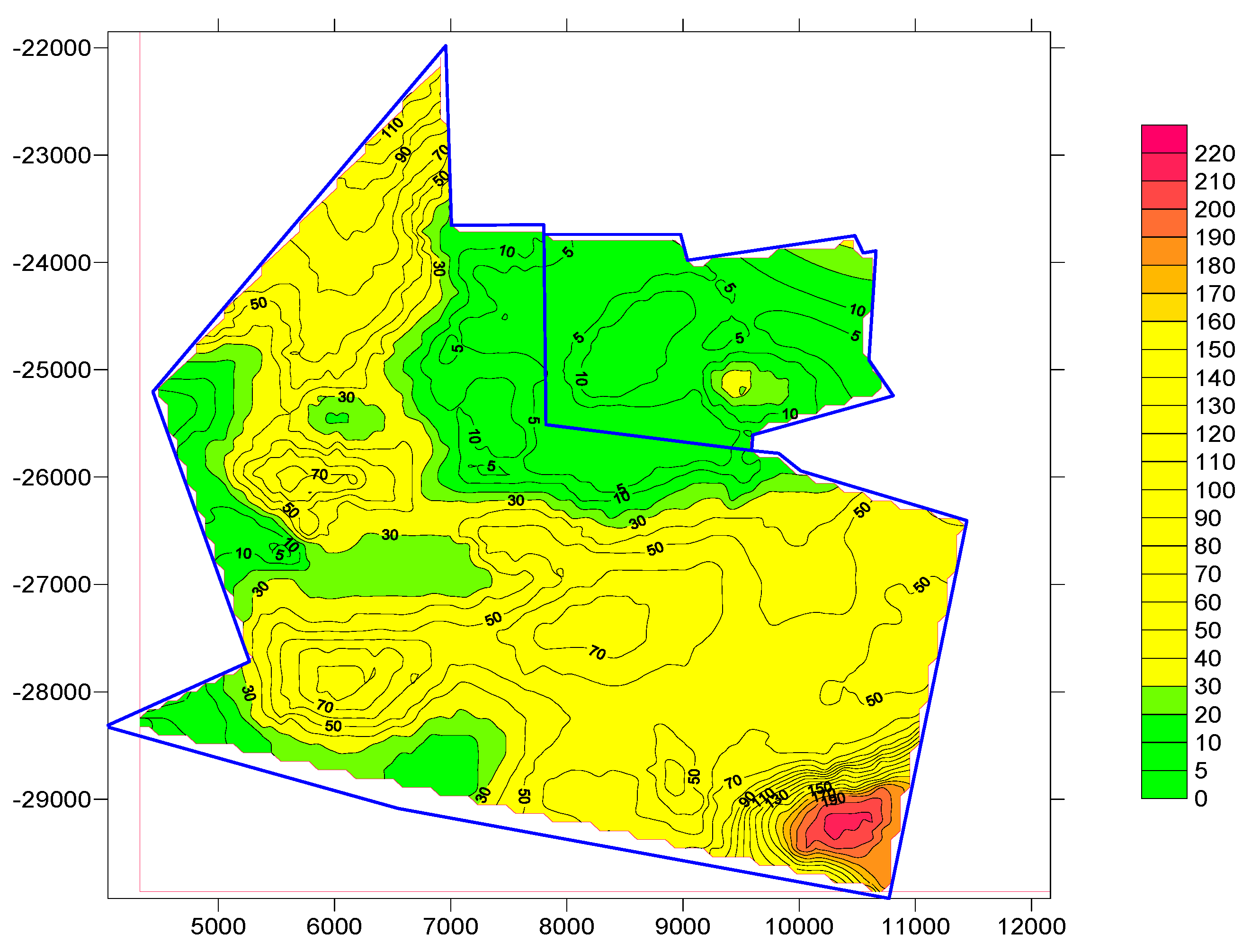
Figure 1 shows a map of permeable formations on the Carboniferous roof. The best conditions for the migration of mine gases are in the northern part of the area. The area is located in the southern hanging wall of the Kłodnica fault. The deposit is riddled with numerous brittle dislocations of different values of the throw.
Based on the methane concentration measurements in mine workings and boreholes, methane concentration distribution in coal seams in the Carboniferous rock mass was analyzed. It included analyses of methane capacity distribution concerning the depth and statistical distribution of methane capacity measurements in given coal seams and mine levels. The statistical analysis of the methane capacity results showed significant differences in its distribution (see Table 1).
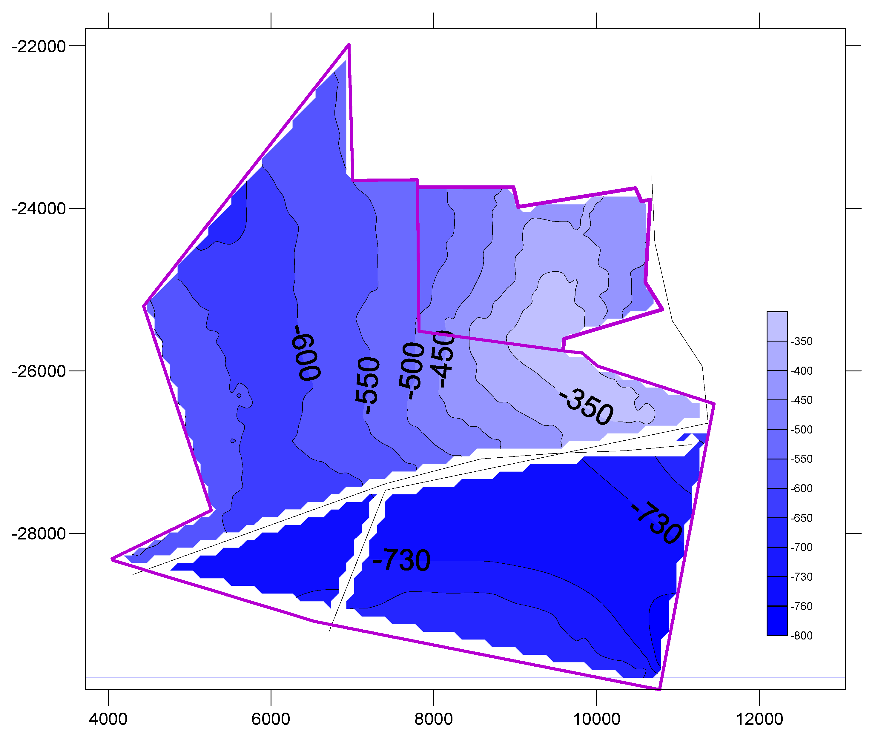
The actual coal seams methane capacity in the analyzed mine was between 0.0 and 7.638 m3 CH4/Mgdaf. The northern part, with the seams closest to the surface, is characterized by low methane capacity, while in the southern part, with the seams of Ruda beds, the methane capacity is elevated, and amounts to 1.125–7.628 m3 CH4/Mgdaf (see Figure 2).
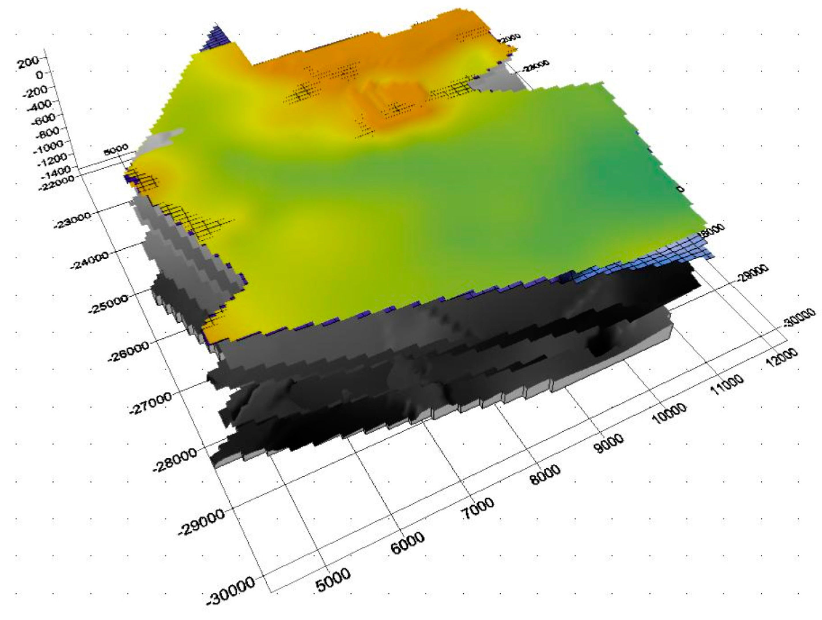
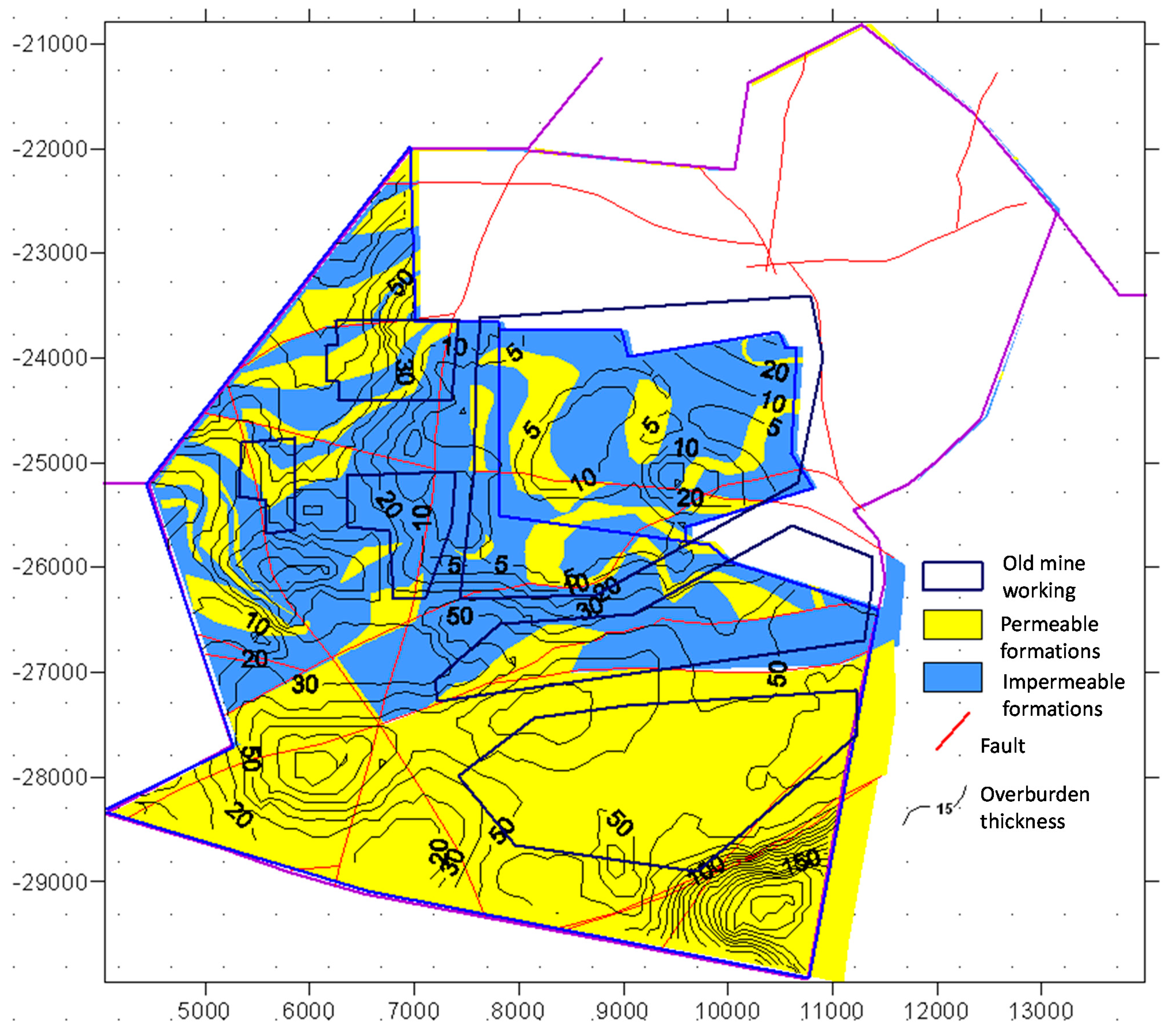
The analyses of lithology and thickness of the overburden of the Carboniferous rock mass, tectonics, methane capacity of the remaining parcel coal seams and previous exploitation enabled the development of a consolidated map and the concept geological model (see Figure 3 and Figure 4), which are the basis for identification and determination of potential zones where mine gases migrate towards the surface.
The analysis of the concept 3D model and the map showed that the zones where the occurrence of gas hazard on the surface is the most probable are located in the centre (the northern part of the analyzed area). The zones are located in the places where the overburden is the thinnest. Outcrops of fault zones are located on the Carboniferous roof, where the rock mass structure disintegrated due to overlapping influences of the boundaries of mining operations in different coal seams.
The numerical models were built for the aforementioned area where the analyzed mine was operated. They were built with TOUGHv2.0 simulator and based on the concept geological model. The basis for the development of the numerical model was the assessment of the variability of parameters of rocks forming the Carboniferous rock mass and the overburden rocks in the area of the mine, where mining operation is ceased, in the aspect of possible migration of mine gases. To do it, a spatial model was built, which included regions, layers and cells. The numerical model of the analyzed area covers 56.25 km2 (7.5 × 7.5 km), and its vertical spread is 750 m. The boundaries of the model were assumed so that the model includes the entire rock mass with exploitation influences. It constitutes a block of irregular shape corresponding to the deposit area. The bottom plane was set at ordinate −485 m a.s.l., while the upper plane, at ordinate +297 m a.s.l., i.e., the surface. The horizontal range of the model is contained within the coordinates X (4500–1200), Y (−22,100–−29,600) according to the Sucha Góra triangulation system. The model recognizes 20 layers of variable thickness. Horizontally, the model is divided into polygons. They were compacted to reflect details of the geological structure and the near-surface conditions, separating additional thinner division of up to 6 m. Altogether, the model consists of 50,000 cells and 30 regions. The regions introduced into the model made it possible to reflect the orientation of given media forming the rock mass, their deposition, and the course of tectonic zones that disturb the medium continuity.
To simulate the physical properties of the model, it was divided into eight different media (four media for Carboniferous, and the overburden, respectively); namely:
- –
- GSP—Upper Silesian Sandstone Series, (layers from seam 510)
- –
- SM000—Mudstone series, (between seam 402 and 364/1))
- –
- KSP00—Cracow Sandstone Series, (between seam 364/1 and Carboniferous roof)
- –
- GOBS—the area of mined coal seams and of heightened permeability,
- –
- ROCK1—permeable medium of the Quaternary overburden,
- –
- ROCK2—poorly permeable medium of the Quaternary overburden
- –
- ROCK3—permeable and poorly permeable Triassic medium—only fragments—patches
- –
- ROCK4—impermeable Tertiary medium.
The parameters assumed for the aforementioned media, determining their physical properties, are presented in Table 2.
The initial conditions of water and gas saturation were as follows. In gobs and the fracture zones, there was a mixture of gas and air. It was assumed that the solubility of CO2 is between 2.5 and 5.0 g CO2/dm3 of water, i.e., between 1.1 and 2.0 dm3 CO2 per dm3 of water in normal conditions. I.e. there should be approximately 45–70% of the volume filled with gases and air (85% of gases and 15% of air) and 30–55% of water in the closed mine gobs. In the gobs of the upper layers, it was assumed that the gases could constitute between 2 and 10% together with air, while the flooded layers ought to be 100% water. The above values are the local boundary conditions of the numerical model.
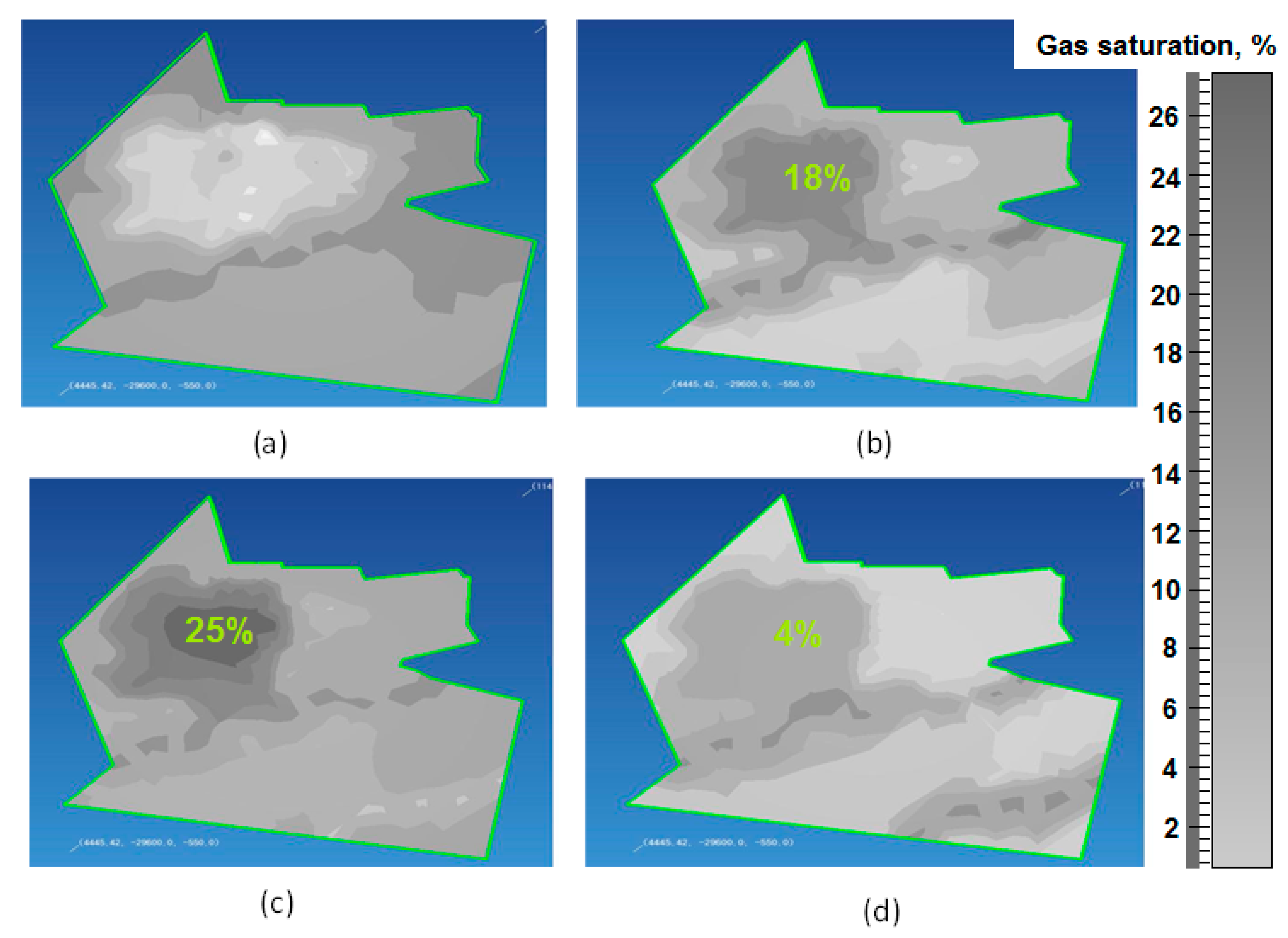
Applying the developed numerical model, several simulations were conducted. They concerned migration of gases (methane) towards the surface. The model was calibrated for the conditions corresponding to the gas contents in gobs, assuming the underground ventilation system is not operating. The obtained results of computer simulations are presented in Figure 5 for particular time horizons, i.e., 0.5, 1, 2.5 and 5 years. There was observed gas flow towards the surface through permeable medium of the rocks forming the Carboniferous overburden for the obtained results of simulations. After five years, the migration in the area of faults, especially the southern fault located in the south-eastern part of the analyzed area, was observed. In the area of shallow gobs located in the northern and central part of the analyzed area in unflooded porous cavities forming the overburden, and in the fracture zone affected by previous exploitation, in the model, 18% saturation in the near-surface layers after 1 year, 25% after 2.5 years, and 4% after 5 years were indicated. The simulations show gas migration towards the surface along the post-mining fractures, which are good methane routes.
4. Conclusions
- Determining places on the surface that are threatened by migrating gases after ceasing coal exploitation included a geological analysis of the rocks in a given coal deposit area.
- Based on the analysis alongside the petrophysical parameters of given geological members, a map was prepared. The map shows the potential routes of migration of mine gases and the areas potentially threaten by their occurrence on the surface. The numerical model which reflected the geological structure of the analyzed area was also built.
- The analysis of the concept 3D model and the presented map showed that the zones with the most probable occurrence of gas hazard on the surface are located in the centre (the northern part of the analyzed area).
- The simulations of gas migration were made with the developed model, and they corresponded with the actual observations of gas migration from the mining areas to the surface.
- The simulations show gas migration towards the surface along the post-mining fractures, which are good methane routes.
- In the area of shallow gobs located in the northern and central part of the analyzed area in unflooded porous cavities forming the overburden, and in the fracture zone affected by previous exploitation, the model showed 18% saturation in the near-surface layers after 1 year, 25% after 2.5 years, and 4% after 5 years.
Author Contributions
Conceptualization, J.C., N.H., K.P. and A.S.; methodology, J.C.; software, J.C.; validation, J.C., N.H., K.P. and A.S.; formal analysis, J.C.; N.H.; investigation, J.C.; writing—original draft preparation, J.C.; writing—review and editing, J.C.; N.H. visualization, J.C.; supervision, A.S. All authors have read and agreed to the published version of the manuscript.
Funding
This research received no external funding.
Institutional Review Board Statement
The study was conducted according to the guidelines of the Declaration of Helsinki, and approved by the Institutional Review Board (or Ethics Committee) of Central Mining Institute.
Informed Consent Statement
Not applicable.
Data Availability Statement
Not applicable.
Conflicts of Interest
The authors declare no conflict of interest.
References
- Sloss, L.L. Potential for Enhanced Coalbed Methane Recovery; IEA Clean Coal Centre: London, UK, 2015; ISBN 978-92-9029-574-7. [Google Scholar]
- Więckowski, M.; Howaniec, N.; Smoliński, A. The effect of flow rates of gases flowing through a coal bed during coal heating and cooling on concentrations of gases emitted and fire hazard assessment. Int. J. Coal Sci. Technol. 2020, 7, 107–121. [Google Scholar] [CrossRef] [Green Version]
- Seidle, J. Fundamentals of Coalbed Methane Reservoir Engineering; PennWell Books: Tulsa, OK, USA, 2011. [Google Scholar]
- Chattaraj, S.; Mohanty, D.; Kumar, T.; Halder, G. Thermodynamics, kinetics and modeling of sorption behaviour of coalbed methane―A review. J. Unconv. Oil Gas Resour. 2016, 16, 14–33. [Google Scholar] [CrossRef]
- Krooss, B.; Van Bergen, F.; Gensterblum, Y.; Siemons, N.; Pagnier, H.; David, P. High-Pressure methane and carbon dioxide adsorption on dry and moisture equilibrated Pennsylvanian coals. Int. J. Coal Geol. 2002, 51, 69–92. [Google Scholar] [CrossRef]
- Shi, J.Q.; Durcan, S.; Sinka, I.C. Key parameters controlling coalbed methane cavity well performance. Int. J. Coal Geol. 2002, 49, 19–31. [Google Scholar] [CrossRef]
- Van Bergen, F.; Krzystolik, P.; Van Wageningen, N.; Pagnier, H.; Jura, B.; Skiba, J.; Winthaegen, P.; Kobiela, Z. Production of gas from coal seams in the Upper Silesian Coal Basin in Poland in the post injection period of an ECBM pilot site. Int. J. Coal Geol. 2009, 77, 175–187. [Google Scholar] [CrossRef]
- Levine, J.R. Generation, storage and migration of natural gas in coal bed reservoirs. Alta. Res. Counc. Inf. Ser. 1990, 109, 84–130. [Google Scholar]
- Więckowski, M.; Howaniec, N.; Postnikov, E.B.; Chorążewski, M.; Smoliński, A. Changes in the distribution of temperature in a coal deposit and the composition of gases emitted during its heating and cooling. Sustainability 2018, 10, 3587. [Google Scholar] [CrossRef] [Green Version]
- Mazzotti, M.; Pini, R.; Storti, G. Enhanced coalbed methane recovery. J. Supercrit. Fluids 2009, 47, 619–627. [Google Scholar] [CrossRef]
- Li, X.; Fang, Z.M. Current status and technical challenges of CO2 storage in coal seams and enhanced coalbed methane recovery. Int. J. Coal Sci. Technol. 2014, 1, 93–102. [Google Scholar] [CrossRef] [Green Version]
- Wojtacha-Rychter, K.; Howaniec, N.; Smoliński, A. The effect of coal grain size on the sorption of hydrocarbons from gas mixtures. Int. J. Energy Res. 2019, 43, 3496–3506. [Google Scholar] [CrossRef]
- Wojtacha-Rychter, K.; Smoliński, A. Selective adsorption of ethane, ethylene, propane, and propylene in gas mixtures on different coal samples and implications for fire hazard assessments. Int. J. Coal Geol. 2019, 202, 38–45. [Google Scholar] [CrossRef]
- Fang, H.; Snag, S.; Liu, S. Establishment of dynamic permeability model of coal reservoir and its numerical simulation during the CO2-ECBM process. J. Pet. Sci. Eng. 2019, 179, 885–898. [Google Scholar] [CrossRef]
- Du, Y.; Snag, S.; Pan, Z.; Wang, W.; Liu, S.; Fu, C.; Zhao, Y.; Zhang, J. Experimental study of supercritical CO2-H2O-coal interactions and the effect on coal permeability. Fuel 2019, 253, 369–382. [Google Scholar] [CrossRef]
- McCants, C.Y.; Spafford, S.; Stevens, S.H. Five-spot production pilot on tight spacing: Rapid evaluation of a coalbed methane block in the Upper Silesian Coal Basin, Poland. In Proceedings of the 2001 International Coalbed Methane Symposium University of Alabama, Tuscaloosa, AL, USA, 14–18 May 2001; pp. 193–204, Paper 0124. [Google Scholar]
- Wojtacha-Rychter, K.; Smoliński, A. The interactions between coal and multi-component gas mixtures in the process of coal self-heating at different various temperatures ranges: An experimental study. Fuel 2018, 213, 150–157. [Google Scholar] [CrossRef]
- Reeves, S.R.; Outinot, A. The Tiffany unit N2-ECBM Pilot—A reservoir and economic analysis. In Proceedings of the International Coalbed Methane Symposium, Tuscaloosa, AL, USA, 16–20 May 2005. Paper 0523. [Google Scholar]
- Kedzior, S.; Dreger, M. Methane occurrence, emissions and hazards in the Upper Silesian Coal Basin, Poland. Int. J. Coal Geol. 2019, 211, 103226. [Google Scholar] [CrossRef]
- Sechman, H.; Kotarba, M.J.; Kędzior, S.; Dzieniewicz, M.; Romanowski, T.; Twaróg, A. Distribution of methane and carbon dioxide concentrations in the near-surface zone, genetic implications, and evaluation of gas flux around abandoned shafts in the Jastrzębie-Pszczyna area (southern part of the Upper Silesian Coal Basin, Poland). Int. J. Coal Geol. 2019, 204, 51–69. [Google Scholar] [CrossRef]
- Dudzińska, A.; Howaniec, N.; Smoliński, A. Effect of coal grain size on sorption capacity with respect to propylene and acetylene. Energies 2017, 10, 1919. [Google Scholar] [CrossRef] [Green Version]
- Kotarba, M. Gas Hazard in the Near- Surface Zone of the Wałbrzych Coal Mine Closure: Geological and Geochemical Controls; Wydawnictwo Akapit Press: Kraków, Poland, 2002. [Google Scholar]
- Checko, J.; Urych, T.; Magdziarczyk, M.; Smolinski, A. Resource Assessment and Numerical Modeling of CBM Extraction in the Upper Silesian Coal Basin, Poland. Energies 2020, 13, 2153. [Google Scholar] [CrossRef]
- Card, G.B. Protecting Development from Methane; Raport CIRIA: London, UK, 1995; p. 149. [Google Scholar]
- Burrell, R.; Whitworth, K. The influence of minewater recovery on surface gas and water discharges in the Yorkshire Coalfield. In Proceedings of the 7th International Mine Water Association Congress, Katowice-Ustroń, Poland, 11–15 September 2000. [Google Scholar]
- Kasimov, O.I.; Kochera, V.N.; Yakovenko, E.A.; Yermakov, V.N. Prediction and prevention of gas danger emissions from closed mines to the surface. In Proceedings of the 28th International Conference of safety in Mines Research Institutes, Sinaia, Romania, 7–11 June 1999; Volume II. [Google Scholar]
- Bear, J.; Verrujit, A. Introduction to Modelling of Transport Phenomena in Porous Media; Kluwer Academic Publishers: Dordrecht, The Netherlands, 1987. [Google Scholar]
- Kidybiński, A.; Siemek, J. Podziemne Magazyny gazu w Zaniechanych Kopalniach Węgla. Praca Zbiorowa Wyd.GIG; Głowny Instytut Gornictwa: Katowice, Poland, 2006. [Google Scholar]
- Krause, E. Safety and Environmental Protection Aspects in Post-Mining Areas Related to the Gas Hazard; Bibliotek Szkoły Eksploatacji Podziemnej: Katowice, Poland, 1999. [Google Scholar]
- Pruess, K. TOUGH2—A General Purpose Numerical Simulator for Multiphase Fluid and Heat Flow; LBL-29400; Lawrence Berkeley Laboratory Raport: Berkeley, CA, USA, 1991. [Google Scholar]
- Pruess, K.; Oldenburg, C.; Moridis, G. TOUGH2. User’s Guides Version 2.0; LBL-43134; Lawrence Berkeley Laboratory Raport: Berkeley, CA, USA, 1999. [Google Scholar]
Figure 1.
Map showing the thickness of the Carboniferous overburden (Triassic, Tertiary and Quaternary sediments) in the analyzed area of coal mine.
Figure 1.
Map showing the thickness of the Carboniferous overburden (Triassic, Tertiary and Quaternary sediments) in the analyzed area of coal mine.

Figure 2.
Surface map of the roof zone of methane content in the analyzed area of coal mine.

Figure 3.
Conceptual 3D geological model for the analyzed area of a coal mine.

Figure 4.
Consolidated map showing the thickness of Carboniferous overburden with permeable and impermeable formations, contour lines of coal exploitation and fault lines in the analyzed area of coal mine.
Figure 4.
Consolidated map showing the thickness of Carboniferous overburden with permeable and impermeable formations, contour lines of coal exploitation and fault lines in the analyzed area of coal mine.

Figure 5.
Distribution of gas saturation in the near-the-surface layer after: (a) 0.5 year, (b) 1 year, (c) 2.5 years, and (d) 5 years.
Figure 5.
Distribution of gas saturation in the near-the-surface layer after: (a) 0.5 year, (b) 1 year, (c) 2.5 years, and (d) 5 years.


Table 1.
Statistical distribution of methane capacity measurements in coal seams.
| Coal Seam | 318 | 330 | 334/2 | 364/2 | 402 | 300 | 400 | 500 |
|---|---|---|---|---|---|---|---|---|
| No. of credible measurements | 4 | 5 | 36 | 6 | 3 | 362 | 30 | 2 |
| Minimal methane emission, m3/Mgdaf | 0.002 | 0 | 0 | 0.31 | 4.399 | 0 | 0.929 | 2.478 |
| Maximal methane emission, m3/Mgdaf | 0.013 | 0.13 | 2.394 | 5.264 | 5.852 | 7.638 | 7.583 | 5.114 |
| Average methane emission, m3/Mgdaf | 0.007 | 0.03 | 0.362 | 2.748 | 5.758 | 0.715 | 4.544 | 3.796 |
| Median | 0.007 | 0.003 | 0.0045 | 0.67 | 0.469 | 0.005 | 4.364 | 3.796 |
| Standard error | 0.0024 | 0.0256 | 0.119 | 2.717 | 0.66 | 0.074 | 0.287 | 1.318 |
| Variance | 0.0036 | 0.041 | 0.518 | 1.163 | 0.62 | 1.0171 | 1.275 | 1.318 |
| Standard deviation | 0.0048 | 0.057 | 0.719 | 1.648 | 0.813 | 1.422 | 1.574 | 1.864 |
Table 2.
Parameters of the rocks assumed for model and simulation calculations.
| Medium | Density, kg/m3 | Porosity, % | Permeability, m2 | Specific Heat Capacity, J/kg | Thermal Conductivity, W/m | Compressibility, 1/Pa | ||
|---|---|---|---|---|---|---|---|---|
| X | Y | Z | ||||||
| GSP00 | 2500 | 11 | 1 × 10⁻¹⁴ | 1 × 10⁻¹⁴ | 1 × 10⁻¹³ | 1000 | 2.0 | 7 × 10⁻¹⁰ |
| SM000 | 2400 | 5 | 2 × 10⁻¹⁵ | 2 × 10⁻¹⁵ | 2 × 10⁻¹⁶ | 1000 | 2.00 | 7 × 10⁻¹⁰ |
| KSP00 | 2500 | 15 | 5.4 × 10⁻¹⁴ | 5.4 × 10⁻¹⁴ | 5.4 × 10⁻¹⁴ | 1000 | 2.0 | 5 × 10⁻¹⁰ |
| GOBS | 1000 | 50 | 1 × 10⁻⁹ | 1 × 10⁻⁹ | 1 × 10⁻⁹ | 1000 | 2.00 | 9 × 10⁻¹⁰ |
| ROCK4 | 2500 | 10 | 1 × 10⁻¹⁴ | 1 × 10-14 | 1 × 10⁻¹⁴ | 1000 | 2.0 | 8 × 10⁻¹⁰ |
| ROCK 3 | 2400 | 5 | 5 × 10⁻¹⁵ | 5 × 10⁻¹⁶ | 1 × 10⁻¹⁶ | 1000 | 2.0 | 9 × 10⁻¹⁰ |
| ROCK2 | 2600 | 25 | 1 × 10⁻¹⁰ | 1 × 10⁻¹⁰ | 1 × 10⁻¹⁰ | 1000 | 2.0 | 6 × 10⁻¹⁰ |
| ROCK1 | 2500 | 10 | 1 × 10⁻¹⁶ | 1 × 10⁻¹⁶ | 1 × 10⁻¹⁰ | 1000 | 2.0 | 7 × 10⁻¹⁰ |
Publisher’s Note: MDPI stays neutral with regard to jurisdictional claims in published maps and institutional affiliations. |
© 2021 by the authors. Licensee MDPI, Basel, Switzerland. This article is an open access article distributed under the terms and conditions of the Creative Commons Attribution (CC BY) license (https://creativecommons.org/licenses/by/4.0/).
Share and Cite
MDPI and ACS Style
Chećko, J.; Howaniec, N.; Paradowski, K.; Smolinski, A. Gas Migration in the Aspect of Safety in the Areas of Mines Selected for Closure. Resources 2021, 10, 73. https://0-doi-org.brum.beds.ac.uk/10.3390/resources10070073
AMA Style
Chećko J, Howaniec N, Paradowski K, Smolinski A. Gas Migration in the Aspect of Safety in the Areas of Mines Selected for Closure. Resources. 2021; 10(7):73. https://0-doi-org.brum.beds.ac.uk/10.3390/resources10070073
Chicago/Turabian StyleChećko, Jarosław, Natalia Howaniec, Krzysztof Paradowski, and Adam Smolinski. 2021. "Gas Migration in the Aspect of Safety in the Areas of Mines Selected for Closure" Resources 10, no. 7: 73. https://0-doi-org.brum.beds.ac.uk/10.3390/resources10070073
Note that from the first issue of 2016, this journal uses article numbers instead of page numbers. See further details here.