Article

Ensuring Resilience of Natural Resources under Exposure to Extreme Climate Events

1
Institute for Sustainable Futures, University of Technology, PO Box 123, Broadway 2007, Australia
2
South East Local Land Services, PO Box 9, Braidwood 2622, Australia
3
Tasmanian Institute of Agriculture, University of Tasmania, Hobart 7001, Australia
*
Author to whom correspondence should be addressed.
Submission received: 29 February 2016 / Revised: 17 May 2016 / Accepted: 3 June 2016 / Published: 8 June 2016
(This article belongs to the Special Issue Difficult Decisions in Disaster Risk and Environmental Management)

Abstract

:
Natural resources directly support rural livelihoods and underpin much of the wealth of rural and regional Australia. Climate change manifesting as increasing frequency and or severity of extreme weather events poses a threat to sustainable management of natural resources because the recurrence of events may exceed the resilience of natural systems or the coping capacity of social systems. We report the findings of a series of participatory workshops with communities in eight discrete landscapes in South East New South Wales, Australia. The workshops focused on how natural resource management (NRM) is considered in the Prevent-Prepare-Respond-Recover emergency management cycle. We found that NRM is generally considered only in relation to the protection of life and property and not for the intrinsic value of ecosystem services that support communities. We make three recommendations to improve NRM under extreme climate events. Firstly, the support to communities offered by emergency management agencies could be bolstered by guidance material co-produced with government NR agencies. Secondly, financial assistance from government should specifically target the restoration and maintenance of green infrastructure to avoid loss of social-ecological resilience. Thirdly, action by natural resource dependent communities should be encouraged and supported to better protect ecosystem services in preparation for future extreme events.

1. Introduction

Natural resources directly support the livelihoods of rural society and underpin much of the economic activity of rural and regional areas globally [1,2,3]. Australia’s natural resource base is in decline and climate change poses an additional threat to the sustainable management of land, water and biodiversity [4]. The impact of extreme climate events such as bushfire, floods and drought in rural and regional areas can be devastating and disruptive to social and economic activity [5]. If the events result in a step-change in the supply of ecosystem services through, for example, top-soil erosion, surface water pollution or local plant and animal extinctions, the consequences for rural and regional communities can be a permanent loss of natural capital and flow on impacts to social cohesion and accelerated rural decline [6].
Projections of future climate suggest that changes to the frequency and/or severity of extreme climate events are likely to occur [7]. Attempts to define extreme events can be made difficult because of a shifting baseline. Taleb’s discussion of Black Swan events emphasises society’s blindness with respect to randomness, particularly in relation to large deviations [8]. Easterling et al. categorise climate extremes into two broad groups: (i) those based on simple climate statistics, which include extremes such as heavy daily or monthly rainfall volumes or very low or very high daily temperatures, that occur annually; and (ii) more complex event-driven extremes, examples of which include severe drought, storms and floods, which do not necessarily occur every year at a given location [9]. Smith defines an extreme event for ecological systems as “an occurrence in which a statistically rare or unusual climate period alters ecosystem structure and or function well outside the bounds of what is considered typical or normal variability” [10] (p. 658). She suggests that in response to an extreme climate event, ecosystems surpass an extreme response threshold with two possible outcomes. Either, an ecosystem over time will recover its “normal” function, or it can undergo a change of state likely accompanied by species loss and invasion [9]. Under climate change, the severity and frequency of events will likely combine to determine the interval required for recovery of social-ecological systems. If the frequency of recurrence is greater than the rate at which the system recovers its pre-event level of function then the socio-ecological system can be pushed beyond certain thresholds (leading to a potential state change), most likely resulting in a loss of resilience in the natural system and/or the coping capacity of the social system [5]. While the potential exists for an extreme climate event that causes local ecosystems to change state, the consequences of such an occurrence would be highly unpredictable and likely beyond the coping capacity of local emergency services and NR managers with lasting consequences for the environment and ecosystem services. Instead, in this paper we consider the case of an event of lesser intensity where the social system responds effectively through management intervention to avoid thresholds, enhance recovery of ecosystems and increase resilience to repeat events [11].
Many local, state and national governments have developed comprehensive disaster management plans that encompass extreme climate events (e.g., State of New York [12], Public Safety Canada [13], Sahin et al. [14]). In Australia, the State Government of New South Wales has well-developed emergency service capability for natural disasters and has implemented a State Emergency Management Plan [15]. It is based on an adaptive management system (learning from past events) and supported by local social capital (through community volunteer services). The Plan uses a 4-phase framework of prevent, prepare, respond and recover (PPRR). In the event of a natural disaster this framework is applied to inform government and its combat and support agencies of the appropriate administrative and operational responses throughout the duration of the event. While the Plan recognises the importance of reducing the level of risk to communities during the prevent and prepare phases, and the restoration of the environment during recover, in practice it focuses primarily, and necessarily, on saving lives and protecting property before, during and after an extreme event. Under climate change, a shift of focus may be required to better address the protection of natural resources from extreme events.
This paper seeks to examine key questions in relation to the protection of natural resources from extreme climate events:
  • Is the PPRR emergency management cycle useful for the range of events experienced by rural and regional communities?
  • How does Government’s view of a community’s progress through the PPRR cycle accord with the lived experience of that community?
  • In practice, how are natural resources currently considered in the management of extreme climate events?
  • How can natural resource management be improved to ensure the prosperity and viability of rural and regional communities for an uncertain future?

2. Results

2.1. Extreme Event Exposure

The community’s perception of exposure in any particular landscape accorded closely with the mapped exposure levels shown in Figure 1 for each event type. Bushfire exposure was discussed in four regions: Palerang, Eurobodalla, Southern Highlands and the Far South Coast of NSW. Hazard mapping Figure 1 indicates that these regions all have large areas of the landscape that are exposed to bushfire; this is often co-located with human settlements, although the areas differ in the reasons for the high level of exposure. For the inland regions, grass fires, were identified as the major cause of exposure to bushfire for agricultural landholders. For coastal regions high levels of bushfire exposure are due to the extent and density of reserve areas (State Forests and National Parks). Exposure to bushfires in coastal areas is heightened by seasonal tourism. The peak tourist period (summer school holidays) coincides with peak fire danger, resulting in an influx of people relatively unconnected to local communication channels and with limited local knowledge of bushfire.
The impacts of drought on the community and NRM were discussed in three regions: Boorowa-Yass and Crookwell-Goulburn and Cooma-Monaro. The hazard map Figure 1 indicates that exposure to drought is high throughout these regions and very high in selected areas. These regions suffer from a combination of relatively variable and unpredictable rainfall patterns and large areas of shallow, sedimentary soils predisposing them to drought. The largely agriculture-based economy in these towns means that the community is greatly impacted by this type of extreme event.
Storms and flooding were discussed at one workshop in the Illawarra-Shoalhaven landscape. Storms resulting from the formation of intense East Coast Low (ECL) pressure systems are one of the most damaging weather events for the entire South East coast of NSW [16]. ECL often intensify rapidly overnight and their relatively weak pattern of occurrence, primarily in autumn and winter, means that coastal residents receive little warning. The hazard map Figure 1 indicates that susceptibility to flooding occurs in discrete locations that coincide with coastal river catchments (and urban settlements). A combination of a narrow coastal plain and many small river catchments amplifies on human populations and high value infrastructure the impacts of sea level rise, storm surges, flooding and subsidence. In addition, the SE Region has numerous shallow coastal lakes and estuaries (including swamps and salt marshes) that are officially recognized as important threatened ecosystems. The lakes are exposed to the risk of marine sediment deposition which limits flushing and replenishment leading to stagnation and eutrophication.

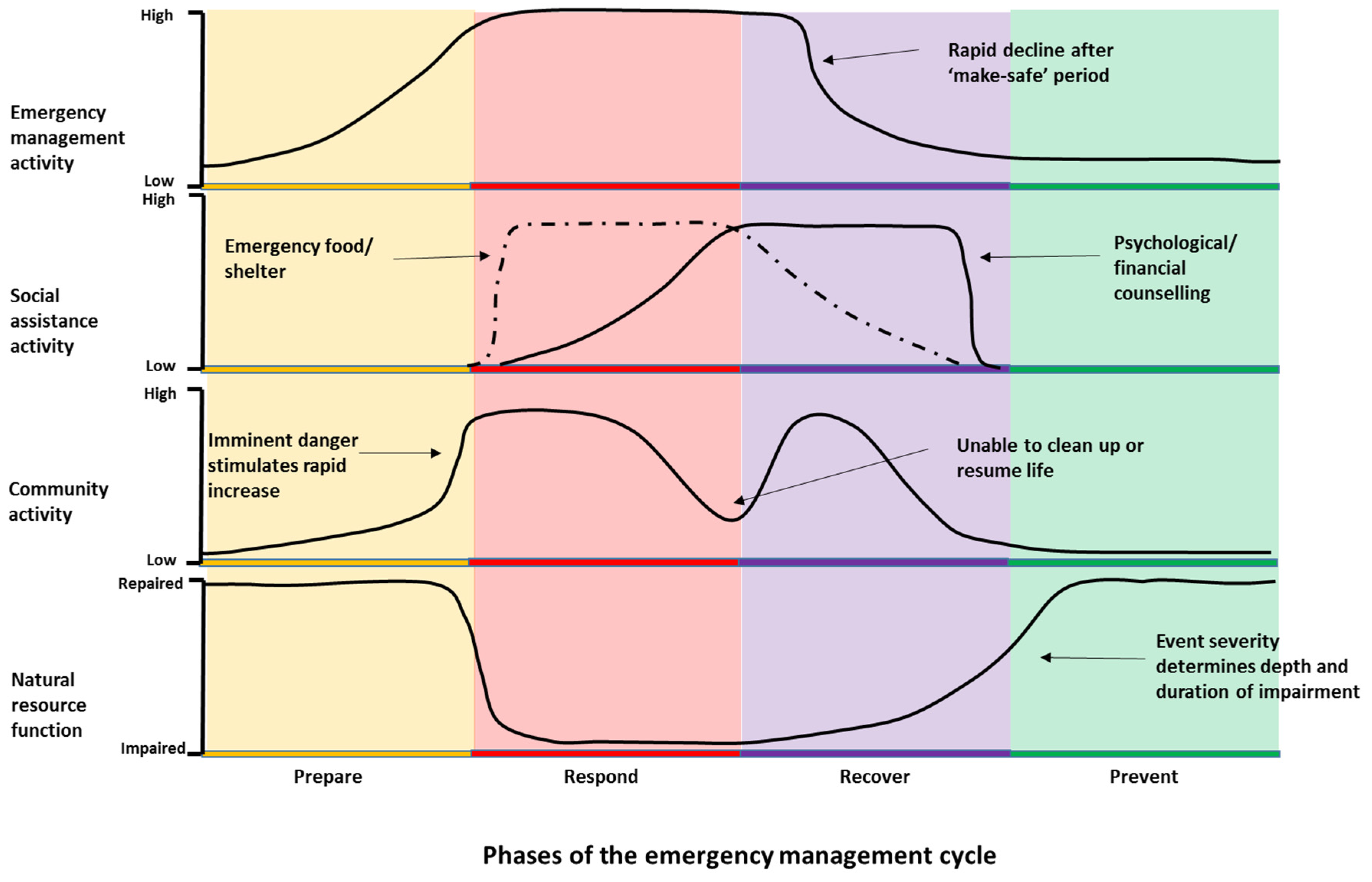
2.2. An Extreme Event Timeline

To frame a discussion of extreme events in the context of improved protection of natural resources that span multiple types of events in multiple regions by multiple actors we propose a theoretical extreme event time line (Figure 2). The timeline illustrates the level of activity that occurs in each phase of the PPRR cycle throughout the duration of an extreme event. It draws on general information elicited through the workshop process and seeks to show how the different types of extreme events can vary from the theoretical, and where the current short comings in the use of the PPRR cycle lie from the dual perspectives of the community and of natural resource management.
The actions of diverse emergency response actors have been grouped into 3 separate timelines: EM service agencies under emergency management activity, NGOs involved in community support under social assistance activity; and, community members not directly involved in volunteer EM services under community activity. An additional timeline seeks to illustrate the impact of an extreme event on ecosystem service provision under natural resource function. Activity ranges across a generic scale from low to high for social actors and from impaired to repaired for NR function.
For emergency service actors, activity increases throughout Prepare, plateaus at a high level during Response and remains high through the “make-safe” period early in Recover. Activity then declines through the remainder of Recover to stabilise at a lower level throughout Prevent. For social assistance actors, activity increases rapidly during early Respond stimulated by the availability of government disaster funding to provide emergency food, clothing and shelter for evacuees. This type of social assistance remains high throughout Respond and declines during Recover as people are able to return to their homes after the “make-safe” period. A second type of social assistance that provides financial and psychological counselling for disaster victims (and emergency service volunteers) increases during Respond and peaks during Recover. These services decline sharply as government funding is withdrawn at the end of Recover. For the community, activity rises sharply in response to imminent danger and marks the change from Prepare to Respond. It then remains relatively high except for a hiatus in activity at the change from Respond to Recover as evacuees are unable to begin clean-up activities while emergency service personnel operate in the “make-safe” period. Community activity then declines through Recover as “normal” life is resumed and stays at a relatively low level during Prevent. Natural resource function declines sharply with the onset of the extreme event, remains impaired during Respond and may rise with the re-establishment of ecosystem services during Recover. The severity of the event determines the depth and duration of impairment. Ideally the level of emergency management and community activities in Prevent and Prepare would be sufficient to ensure protection of the natural resource base during the event and complete repair of natural resource function during Recover. It should be noted that none of the event types examined in workshops conforms perfectly to the theoretical timeline.

2.3. Activity in the Extreme Event Management Cycle

2.3.1. Prepare

Bushfire

The threat of bushfire is seasonal and there is a well-organised bushfire awareness-raising program delivered by emergency services that targets the community—especially in the lead up to the bushfire season. Despite this program, most of the community rarely focuses on bushfire until late in the preparation phase when fire risk is already “Extreme”. Action in this phase by rural landholders was likely to be anticipatory and driven by local knowledge of the significance of weather patterns—prolonged hot, dry and windy conditions coupled with official weather forecasts, particularly of lightning strikes, and public hazard signs. Participants reported looking for signs in the landscape, such as bushland that is low in moisture, or the build-up of fuel in natural areas. NRM action reported to take place in preparation and prevention phases is similar and is largely centered on removing native vegetation such as Eucalyptus from around dwellings, or replacing native trees with non-natives such as deciduous trees. Where possible, rural landholders reported attempting to mitigate risk by:
  • incorporating fire and wind breaks into native plantings,
  • using grazing management or slashing (contentious due to the risk of sparks) to reduce the threat of grass fires; and,
  • clearing understory vegetation to reduce fuel loads in selected areas.
In the Prepare and Prevent phases emergency management agencies and Local Councils engage in fuel reduction activities such as prescribed burning, mechanical clearing/slashing, trimming trees, maintaining fire trails and Asset Protection Zones (APZ’s). However, these activities can have negative consequences for NRM and are reportedly increasingly contentious among communities. Some coastal residents felt that “hazard burning, reducing canopy cover and loss of moisture increases vulnerability”.

2.3.2. Response

The transition from the Prepare phase into the Respond phase occurs when a warning is communicated via the local radio, television or through RFS website or text messaging. In this phase people will smell and/or see smoke or may be subject to ember attack on their properties. However there is often confusion over the exact location of a fire and its direction of movement.
The primary focus in the Respond phase is protecting lives and property, yet this often comes at the expense of natural resources. Landholders open gates and cut fences to allow livestock to roam free, and firebreaks and fire trails are created with bulldozers—which can inadvertently damage sensitive ecological communities (EECs or riparian zones) and may require extensive rehabilitation once the fire has passed. Phosphate-based chemical suppressants may be used to fight fires in remote areas, in spite of the fact that native vegetation is known to be sensitive to phosphate levels and the impact of fire suppressants is largely unknown. One RFS volunteer explained that the local RFS “try to protect trees with hollows for nesting sites by wetting them down”. The use of Remote Area Fire Teams (RAFT) to quickly extinguish fires in inaccessible areas as a result of lightning strikes drew some criticism because it was seen as interrupting the natural hazard reduction processes that occur through regular burning and increased the likelihood of future catastrophic fires.
The key combat agency in managing bushfire response generally views protection of natural assets as a low priority. In a field operation, decision-making is necessarily rapid, and reactive to local conditions. Allocation of resources is prioritized for the protection of life and property (often the lives of the fire crews themselves are in serious jeopardy). Under such circumstances, particularly in intense, large-scale fires, there is little opportunity to implement any plans for the protection of natural assets that might have been formulated in prevention and preparation phases.
There are a limited number of NRM-focused activities that landholders engage in during the Respond phase due to the brief period between a warning and the arrival of an event. Landholders reported making small sources of water available for wildlife during hot weather and fires. However, personal household and rural property fire plans are not currently required to focus on aspects of natural resource management.

2.3.3. Recovery

The Recover phase attracts considerable external resources and mobilises support within the affected area, which can be local or regional in scale. After a bushfire, NGOs provide initial support with government funding, as well as the immediate physical needs (such as food, emergency shelter, and clothing) and social needs (such as psychological and financial counselling) of the community. Funding is channeled toward replacement of essential public assets, and reconstruction of private assets, such as housing, using insurance payouts where available. Government funding is generally withdrawn before the recovery phase is complete. This is critical for natural resource-dependent businesses. Agricultural landholders in particular are often socially isolated and have slower rates of economic recovery than urban communities because rural livelihoods are closely tied to rates of recovery in the landscape.
The demarcation of the Respond and Recover phases is blurred. Participants, particularly those involved in the RFS, generally acknowledged that there can be an extended “make-safe” period after a fire-front has passed. During this time, the risks of fires may continue for long periods (up to weeks) resulting in a need for on-going vigilance placing a heavy physical and psychological burden on communities. When people return to their properties, lives can still be significantly at risk due to falling trees and unsafe buildings.
For landholders, natural resource-based livelihoods damaged by fire can take an extended time to recover. Natural resources identified as being degraded by fire include: soil health, water quality, vegetation cover (including sown pasture) and native animal populations. Efforts in the recovery phase focus on the need to rehabilitate areas “opened up” by fire and attempts to control it (such as fire breaks), which involve re-establishment of vegetation and control of erosion. The success of these actions is often dependent upon prevailing weather conditions that can limit plant growth (heat, lack of soil moisture) or exacerbate soil loss and weed invasion (rainfall). Other recovery efforts focus on managing water quality, weeds and attending to injured animals.
Loss of livestock has a direct economic impact on agricultural industries, and this is often exacerbated by a lack of adequate insurance cover. Native animals that survive fires can become disoriented; they may have difficulty finding habitat and food, and may be exposed to predators or struck by cars in attempting to relocate to unburnt areas. Communities often need to rehabilitate or euthanise animals (native fauna, livestock and domestic pets) burnt or injured by fire with assistance from wildlife recovery groups and local vets, which adds to the psychological burden of adjusting to the aftermath of disaster. All of these actions incur a cost to the community and the burden often falls inequitably on rural landholders because there is a lack of specific funding for remediation. Concerns were expressed by these communities that an increase in fire frequency and intensity may result in permanent changes to ecosystems, exacerbate the loss of biodiversity and fundamentally change communities in these regions.

2.3.4. Prevent

Because bushfires rely on a combination of specific weather conditions and fuel load, a fire event generally lowers the risk of a subsequent event, providing a period of respite in which prevention measures can be implemented. However, severe fires that cause major socio-economic disruption to communities can result in significant delay and “blurring” in the transition from Respond to Prevent. Individual social groups, businesses (particularly natural resource dependent-businesses) and aspects of community well-being (such as mental health) may recover at vastly slower rates. These factors are currently unaccounted for during the Prevent phase, which is defined as a return to “normal” following an event.
El Nino forecasts were identified as one trigger for action in the prevention phase because they raise expectations of warmer and drier weather periods. However, some rural landholders disagreed, suggesting that they paid little attention to these types of announcements as “they make that prediction every year”.
Participants outlined a number of preventative actions that can reduce their exposure to bushfire risk whilst contributing to NRM such as soil, water and vegetation management and planting layout. In common with the Prepare phase, some actions are contentious within the community such as hazard reduction burning and clearing native vegetation from around properties. NRM activities that are more sensitive to the local environment were identified as planting less-flammable native species (e.g., Allocasuarina verticillata was suggested) in clumps, in a line or to create a wind-break to interrupt the path of the fire. In addition, removal of fuel such as fire prone invasive grasses (e.g., Eragrostis curvula, African lovegrass) was seen as a priority. The management of water focused on the collection, storage and pumping of water close to dwellings for firefighting, as well as encouraging moisture retention generally in the landscape and reducing evaporation.
The prevention phase is most important for NRM but much of the community is disengaged from the awareness-raising efforts of emergency services. Disengagement was attributed to two main factors:
  • Coastal communities with little recent experience of a major fire. The previous large fire on the Far South Coast was 20 years ago (1994). Population growth and turnover has reportedly contributed to a loss of local knowledge and a breakdown of community networks through urbanisation and rural land-use change.
  • The seasonal nature of fire risk leads to community complacency and a disinterest in preventative action when fire events fail to materialise. While the community routinely identified the RFS as a trusted source of information and assistance, they were often at a loss to describe what other social and information networks or services they might draw upon in the event of a fire.
Landuse planning decisions, in relation to new residential developments that fail to take into account current and future fire risks (which are likely to increase in frequency and intensity) were linked to adverse impacts upon NRM, often requiring risk-mitigation activities that are damaging to sensitive coastal ecosystems.

2.4. Drought

2.4.1. Prepare

The Prepare phase for drought was likened to “a train crash you see coming for a period before it hits”. Landholders in all three areas reported monitoring the Bureau of Meteorology (BOM) forecasts of the Southern Oscillation Index and El Nino warnings. However, as with bushfire, they felt that the value of the warnings was diminished by their inaccuracy. Instead landholders monitor subtle signs within the local landscape such as feed levels, pasture and plant growth and water levels in creeks and dams. For larger-scale commercial farms, landholders reported using a general heuristic for drought preparation, with failed autumn rain as the initial warning, followed by failed spring rain, which indicates the onset of drought:
“When the spring rains failed last year, farmers started preparing for drought”.
Drought workshop—Crookwell-Goulburn landscape
Participants agreed that “you have to be prepared at all times to respond to drought”, and that there is “nothing lost” in undertaking preparations. Drought preparations were considered good management practice in an “unpredictable climate”. Preparation activities focus on the capture, retention and distribution of water in the landscape via landscape-based water harvesting, dam and weir maintenance, reticulating and recycling (particularly on smaller-scale properties) water to draw on during drought. Monitoring and maintaining groundcover is seen as critically important to prevent erosion. Landholders plant perennial grasses, swales and deep-rooted trees to improve retention and access to soil moisture.

2.4.2. Respond

Unlike bushfire, there is often little clear distinction between Prepare and Respond phases for drought. The slow but progressive onset of drought makes it difficult for people to realise they are in the Respond phase:
“By the time you realise, you are already in a drought”.
Drought workshop—Boorowa-Yass landscape
The Respond phase is evidenced by ongoing deficit of rainfall, particularly during periods of high evaporative demand, loss of surface water, lack of pasture growth, and vegetation die back. The adaptive responses are highly localised as landholders review their situation in terms of water reserves, livestock numbers, availability and cost of feed and their financial situation. Drought has a severe impact upon animals through reduced access to pastures, loss of condition and increased likelihood of disease. Landholders weigh up the potential damage of stock management actions on natural resources such as the pasture base and soil condition. Landholders reported the widespread adoption of practices such as “sacrificial paddocks” (paddocks reserved for high-intensity grazing) and drought feed lots, as well as constant adjustment of stock numbers using computer software-based management tools, if available. They also use drought as an opportunity to remove accumulated sediment from dams to increase their capacity while they are dry, and to repair fencing. Drought also affects biodiversity through reduced habitat availability and quality e.g., paddock trees often have hollows for arboreal animals but these trees are susceptible to die back during drought. Erosion and dust storms can also reduce water quality and low water levels negatively impact on aquatic biodiversity.
Unlike other extreme climate events, drought fails to attract an emergency management response. This is most likely because of the spatial variation in onset, the slow progression from Prepare to Respond and the often vast scale of the disaster. Community-based NRM groups (e.g., Landcare) can act to mobilise volunteers for NRM; however, landholders reported a decline in Landcare membership during drought because people become more focused on the management of their own property rather than undertaking NRM action on public land (particularly smaller-scale landholders). Would-be volunteers become short of time because of the additional burdens of hand-feeding stock (larger-scale landholders), stock transport and sales. Hand feeding is increasingly difficult for an ageing farm population, often comprising single owner-managers on large properties. Long-term droughts can contribute to the erosion of local NRM skills and knowledge, which would normally be mediated through social networks. Government agriculture and NRM agencies were identified as contributing to community cohesion and resilience in some areas. While Government may declare an area as drought affected this may not trigger support, as the duration of the response phase is unpredictable.
The decline in social networks during drought can exacerbate feelings of isolation for people on rural properties. As a consequence landholders socialise less frequently as the drought progresses—often at a time when they are most in need of support. Landholders reported that those most in need were often likely to be isolated before the drought, and therefore even less likely to seek any social assistance or counselling services. Unlike bushfire, where communities come together to “fight” and organisations such as the RFS provide a social focus around action, drought erodes family and community structures. Drought-induced suicides among landholders are disproportionately common, having a huge impact on both families and the wider community. Communities do attempt to alleviate the isolation through social events such as drought buster parties (“a reason to have a drink when there’s no reason”, Monaro landscape). Participants emphasised the need to have healthy and alert farmers able to act on signs of recovery. Community mental health was considered a largely hidden aspect of extreme droughts and a depressed community was thought to be much slower to act and less innovative in response and recovery.
Extensive grazing is the major agricultural activity in the Southern Tablelands and Alpine regions of the South East. Declining terms of trade have severely eroded the profitability of grazing enterprises, particularly on more marginal land. One Alpine (Monaro region) grazier explained: ”I’m running out of corners to cut”. Drought further reduces landholders’ financial reserves and can leave them with a burden of debt that remains long after the drought has ended. This in turn means that landholders are unable to afford to finance prevention measures. There is reportedly a lack of funding for NRM activities for limiting the impact of drought and when drought assistance is provided it is often “too little too late”. Where funding is available, applications have to be very detailed in order to justify a grant, requiring extensive administration, monitoring and very-technical reporting. This is often beyond the capabilities of volunteer organisations or single landholders already experiencing stress, and many are discouraged by the conditions or lack the time or expertise to submit a funding application.

2.4.3. Recover

As with bushfire, the biophysical, financial and psychological aspects of communities recover at different rates. Some participants noted that recovery starts when you “get good pasture growth, not just good rain” (biophysical) but others said that recovery does not begin until stock levels have returned (financial) and the communities have recovered from the shock (psychological). Depending on the extent of the drought, recovery can proceed for several years rather than months, and some communities undergo permanent changes from which they never “recover”. In some landscapes graziers believed that they did not recover fully from a drought in 1982, because it marked a step-decline in rainfall that permanently lowered productivity. While returning stock to paddocks is a matter of urgency for financial recovery this is often difficult because stock prices are high during recovery. Landholders believed that the South East’s unpredictable climate means that there is not really a well-defined recovery phase:
“It’s more of a respite from the next drought than a recovery. You cannot be confident you are in a recovery phase”.
Drought workshop—Boorowa-Yass landscape
A bank of moisture in the soil can provide some confidence that the drought is ending but loss of vegetation cover results in poor rainfall retention, lower infiltration and high levels of run-off. Erosion is a problem in the Recover phase and is worsened by past clearing of native vegetation, poor agricultural management practices unsuited to the region’s soils and overstocking. Invasion by new species of weeds can be problematic as the lack of ground cover provides little competition for species introduced through imported feed or purchased replacement stock.
Smaller landholders reported maintenance of ground-cover through composting, re-seeding paddocks with legumes, encouragement of native perennial grasses and planting fodder such as lucerne. Both large and small-scale landholders reduce erosion through improved grazing management and fencing of riparian and woodland zones from livestock. They recognised the importance of allowing bare soil to re-cover, providing protection from wind and rain.
Recurring drought is reportedly influencing the range of some native animal species. For example, landholders reported higher numbers of wombats in areas not previously observed. Workshop participants feared permanent changes to the region’s ecosystems as a result of frequent drought and agreed on the need for a more holistic view of landscape management that considers native flora and fauna.

2.4.4. Prevent

As with bushfire, the activities undertaken to protect NRM in the Prepare and Prevent phases are similar. Landholders focus on trying to “drought proof” properties by planting trees to form windbreaks, and block plantings of native drought resistant species and deep-rooted perennials. Some landholders have trialed plantings of tree-fodder species (such as Tagasaste or “tree Lucerne”) but were unable as yet to report on its efficacy as drought fodder (however, one grazier emphasised that “you would need a lot of tree lucerne to provide anything more than a minor supplement to forage supply in a drought”, Boorowa-Yass landscape).
Retaining water in the landscape is an important way to reduce exposure to the impacts of drought. Participants noted that direct drilling technology can improve the condition of soils and reduce land degradation by avoiding the compaction associated with repeated passes of heavy machinery. Soil condition and ground cover can be maintained also by sound rotational grazing management, although in some areas changes in property ownership, an influx of absentee landholders and smaller-scale holdings often see farms over-stocked by inexperienced landholders. Fencing sensitive areas such as gullies and creeks to prevent disturbance by cattle was also seen as an important way to protect riparian zones. Most landholders adopted reticulation and troughs to supply water to livestock, but agreed that this environmental improvement came at the cost of extra infrastructure, monitoring and maintenance of water points. Landholders also reported controlling willows and planting natives such as Eucalyptus viminalis (manna gum) along river banks.

2.5. Storms and Flood

In contrast with drought but in common with bushfire, storm and flood events have well defined stages. Storms generally have a very rapid onset (i.e., short preparation phase) followed by a relatively short duration (or response phase) due to the relatively rapid rise and fall of flood waters in short coastal catchments. However, as with the other extreme climate events the damage caused can result in a prolonged recovery phase. The State Emergency Service (SES) is the combat agency tasked with coordinating the response to storms and flood.

2.5.1. Prepare

Of the three types of events examined in workshops storms appear to have the least well-developed Prepare phase. In general, little action is undertaken by the community in the Prepare phase to reduce threats of storms because of the unpredictable nature of ECLs with very short (often only hours) advanced warning and, unlike bushfire, the lack of a defined “storm season”. As a result, the community is frequently unprepared. At the time of the workshops there was no institutionally-supported planning process in place to deal with East Cost Lows in same way as the RFS supports household fire plans for bushfire events. Lack of preparation has consequences for protecting life and property and for the management of natural resources.
Given the limited potential for action in the Prepare phase, awareness-raising to promote “storm readiness” needs to shift to prevention throughout the year—not just when the threat of storm or flood is imminent. Workshop participants agreed on the need for a “household storm plan” (similar to a fire plan) that outlines how to mitigate risks for personal safety and assets to reduce damage to life and property as well as natural resources. For example, during storms unsecured gas bottles (from caravan parks), chemical drums (from rural properties) and other buoyant debris are dislodged and move with the flow of flood water. These materials end up in waterways and are often deposited in inaccessible areas of estuaries, wetlands and swamps where they become a long-term litter problem adding to pollution. Planning for “storm readiness” should encourage behavior in the community that prevents these potentially hazardous materials from entering the environment. Participants referred to “tree hysteria” among local residents following wind events, which results in widespread calls for trees to be cut down with little or no thought to tree preservation or environmental impact. The localised nature of storms can result in long intervals between major flood events, which present a challenge to overcoming inertia and loss of knowledge in the community.

2.5.2. Respond

As with other extreme events there is inadequate consideration of NRM in the Respond phase for storms and flood. The focus of emergency services includes coordinating other combat and support agencies, sandbagging to control inundation, securing storm damaged properties, keeping evacuation routes open and assisting in the evacuation of the community. Workshop participants agreed that natural resource management is rarely considered during the response phase and that actions to manage the event can cause unintended consequences for the environment. For example, riparian areas subject to inundation are often managed with heavy earth moving machinery such as bulldozers to control bank stability. Little consideration is given in these operations to their impact on river and lake water quality and loss of top-soil and seed banks. Beaches are routinely used to collect and fill sand bags for flood control. There is some uncertainty around the legality of this action and there is currently no guidance for emergency workers on the most appropriate location for sand collection.
The severity of the storm event reportedly modifies the ability of the emergency services to respond. Very severe storms can make it unsafe for the SES to send out emergency response crews, leaving the community particularly exposed to the likelihood of disruption of essential services such as power, water and telecommunications. Participants identified a lack of clarity around the processes of communication during storm events. Calls to local council regarding problems with trees are reportedly transferred to council’s tree management office. Unlike the SES, these staff may not be trained in dealing with emergency management situations.

2.5.3. Recover

In common with other types of extreme events, recovery for the community can be slow and support is often withdrawn before economic and social recovery is complete. Flood waters can remain in low lying areas for long periods. There can be an extended period of “make-safe” where flooded properties require inspection to ensure electrical hazards have been addressed before residents are allowed to return to begin the clean-up process.
For NRM, much of the work undertaken by community-based NRM groups with government grant funding can be damaged or lost during floods. Despite the high risk of loss of restoration works in riparian areas, there is no provision of funding to replace riparian remediation works following a flood event. NRM volunteers at the workshop indicated that replacement of storm-damaged NRM works would require a new funding application, with no guarantee of success, which can be disheartening for NRM workers. In addition, action to clear waterways and coastal lakes of sediments involving dredging can impact the fragile estuary environments.

2.5.4. Prevent

Workshop participants recognised that flood prevention was a whole-of-catchment issue. Land use change in the upper catchment affects flood risk in the lower catchment. Some locations have a limited floodplain and the cumulative impact of urban development increases impervious areas with dramatic effects on the volume and velocity of surface runoff, exposing areas to the risk of erosion and flash flooding. For coastal areas subject to beach erosion and storm surges, participants feared that the natural coastal protection features, such as dune systems and the vegetation they support are being damaged through residential development. Aside from the significant loss of these endangered ecosystems, the damage to “bio-protection” buffering increases the exposure of beach-side dwellings to storm impacts. There is a need to spatially identify areas exposed to the impact of storms and flooding to ensure that future developments consider the increased risk of extreme ECL events.
Riparian restoration is a focus of NRM actions in coastal catchments to prevent stream bank erosion. However, workshop participants identified some NRM actions in riparian zones as producing downstream consequences in floods. In particular, the materials such as weed matting or bamboo canes used to assist re-vegetation efforts are often washed downstream during a flood, adding to pollution in estuaries.
Participants felt that planning for storms in coastal catchments must become a more integral part of community preparedness for extreme events. In particular, the community needs to become much more aware of the role of ecosystem services in coastal protection. The current mindset appears to allow degradation to occur, then replace green infrastructure with inadequate (non-adaptive) engineered structures, which are prone to failure and can be more costly than green infrastructure.

3. Discussion

Four questions were posed in the introduction to this paper in relation to the protection of natural resources from extreme climate events. The narrative constructed in the results about each type of event will be interrogated to discuss these questions.

3.1. Is the PPRR Emergency Management Cycle Useful for the Range of Events Experienced by Rural and Regional Communities?

The PPRR emergency management cycle is a useful concept to engage rural and regional communities in the generic responses to extreme climate events including the roles of government combat and support agencies and NGO social services [17,18]. It also helps to identify the responsibilities of local communities for ensuring their own readiness for extreme events. However, it has limitations. For example, in practice, variations among the types of extreme events, the hazards within specific landscapes and the capacity of discrete communities within the South East region [19,20] most often means that the PPRR cycle does not accord with the lived experience of a community. Participants generally agreed that there was considerable blurring of the demarcation between prevent and prepare phases, particularly where the former may be abruptly truncated (as is the case with coastal storms).

3.2. How Does Government’s View of a Community’s Progress through the PPRR Cycle Accord with the Lived Experience of that Community?

The question of divergence among government and community perceptions of the PPRR cycle is important because the cycle is embedded in central government’s emergency management policy, which in turn determines the broader governance of an event. The duration of each phase of the cycle from the community’s perspective will depend on the type of extreme event. For drought the Prepare phase progresses slowly merging into Respond and results in a gradual deterioration of natural resource function that underpins economic activity, with flow on effects to community social cohesion as the drought continues [21]. For bushfire the threat is regular and seasonal but the high risk period is being extended by changing climate so that Prepare and Prevent phases are becoming less well defined. Community interest tends to wane through the need for a constant state of readiness [18]. Storms are unpredictable and of limited duration so Prepare and Respond phases are correspondingly short allowing little opportunity for community action.
Recovery, or the ability to bounce back from shocks, is central to theories of social ecological resilience [22]. However, the recovery phase of the PPRR cycle is the most complex, hardest to manage and, in many ways, the most critical phase of the cycle. The often protracted nature of recovery and its reliance on local context make it difficult for centralised responses from government. The speed of recovery varies across economic, social and environmental components of social-ecological systems. While economic recovery can be slow, it is supported through rebuilding of private assets with insurance payouts, and essential public infrastructure through government disaster funding. Social impacts of extreme events, particularly those on mental health, are becoming recognised as increasingly important if not always fully addressed [23]. Recovery from bush fires generates high public interest and is often a focus of media attention because they are of relatively short duration and provide moving images (e.g., media coverage of the anniversary of the 2013 Blue Mountains fire event). While drought generates sympathy in urban communities, its longer duration can result in media fatigue and waning public interest [24]. It was clear from workshops that community workers believed that government social assistance for extreme events is withdrawn well before many members of the community recover.
The combined duration of Recover, Prevent and Prepare phases is equivalent to the interval between single events. This interval varies with the type of event and, for some events, is also influenced by natural resource function. For example the incidence of major bushfires is dependent on weather conditions and fuel load. Fuel load is removed by fire (either an event or a hazard reduction burn) providing a period of respite between events while vegetation recovers. Droughts often occur as clusters of dry spells following ocean temperature cycles (measured by the Southern Oscillation Index) punctuated with periods of wetter conditions [25]. Storm events, which can lead to flooding, however, could occur in close succession. There is also the increasing potential for multiple events to occur consecutively: drought leading to higher incidence of bushfires followed by intense rain and flooding, which further blurs the phases of the EM cycle.
The concept of “normalization” to climate change and extreme events to build community resilience and self-reliance is becoming central to government disaster planning [26]. Extreme events often accelerate autonomous adjustment processes that are ongoing in regional areas. However, long term or catastrophic events can overwhelm a community’s coping ability leaving it unable to recover without external assistance. Various alternative models of government support under drought have been proposed (e.g., [27,28]). Landholders that participated in the drought workshops understood and accepted short-term dry periods (1–2 years) as part of the agricultural production environment. They generally agreed that land managers should be expected to plan for such regular events. However, their ability to set aside sufficient reserves to manage for severe droughts (such as the Millennium Drought from 2002 to 2007 [29]) appears beyond their capability. There is evidence in the high incidence of rural family breakdown, farmer suicides and rapid demographic/land-use change in rural Australia that coping strategies are being already overwhelmed. The wisdom of a government policy stance for extreme events in rural and regional communities that relies heavily on building and maintaining local community resilience is questionable in the knowledge community coping will be exceeded in the future. It may be necessary to facilitate local transformation in order to preserve regional resilience [30,31,32].
Rates of recovery also depend on the re-establishment of ecosystem service provision particularly for natural resource dependent livelihoods (such as agriculture and tourism). For the SE Region, grazing enterprises, which are the dominant form of agricultural production, are particularly hard hit because recovery depends not only on plant growth rates (pasture availability) but also on having sufficient stock numbers to harvest available pasture mass. Stock numbers depend in turn on breeding rates and or ability to purchase suitable animals (usually unavailable because of high prices following widespread drought). There is already considerable autonomous adaptation occurring in response to a range of drivers including variable rainfall. These adaptations include changed practices (drought feedlots, adaptively managed stocking rates), changed land-use (both fragmentation of “unviable” farms and consolidation of agriculture on land of higher capability) and a shift to other livelihood options (reliance on off-farm employment, non-resident ownership) [30,31]. Further change along some of these pathways may be limited. For example amalgamation of properties to achieve economies of scale at low stocking rates is limited by labour availability. It is likely that socioeconomic tipping points will be exceeded with only small future changes to production environments (such as further declining terms-of-trade) coupled with increased intensity or frequency of extreme climate events [33].
In light of our discussions with a broad range of local communities we suggest that the uniform application of the PPRR cycle in all landscapes and for all types of extreme climate events often fails to account for the needs of the local communities it is intended to support.

3.3. In Practice, How Are Natural Resources Currently Considered in the Management of Extreme Climate Events?

This research suggests that despite the intrinsic value of natural resources in supporting rural and regional communities, they are seldom explicitly considered in the management of extreme events. Actions to better protect the natural resource base are unlikely to occur during the response phase, where protection of lives and property will remain the priority and under the control of emergency management combat agencies, especially for large scale events. Instead, protection of natural resources from extreme events should focus more attention in the Prevent phase. Our greatest concern is that unlike infrastructure assets, which often incorporate adaptive improvements during rebuilding [34], natural assets are largely expected to recover autonomously. Where the frequency or severity of events does not allow time for recovery of ecosystem function before a succeeding event, ecosystems may decline, ultimately losing resilience and transforming into undesirable states [20] that fail to provide essential ecosystem services for natural resource dependent communities (Figure 3).

3.4. How Can Natural Resource Management be Improved to Ensure the Prosperity and Viability of Rural and Regional Communities for an Uncertain Future?

In conclusion, we propose some changes to the hypothetical extreme event time line (Figure 2) to improve the management of natural resources. These following three changes are a synthesis of information from all of the workshops and do not relate specifically to one type of event or individual landscape:
  • Increased activity by emergency management combat agencies to advise and support communities, particularly rural landholders, to sensibly manage vegetation on private land so that over-clearing and “tree hysteria” is limited. The information required to undertake such additional activity may require greater co-operation among combat and natural resource support agencies to formulate local guidance material.
  • Increased social assistance from government that specifically-targets the restoration and maintenance of living green infrastructure, particularly where it has been damaged by recent extreme events and is essential to the ongoing protection of communities (such as dune systems in coastal regions) in order to reduce the potential for loss of resilience (Figure 3).
  • Increased community activity to protect natural resource-dependent livelihoods, which includes action on both public and private land. The availability of social assistance funding for natural resource restoration could be used as a catalyst for this activity, which would not only protect ecosystem services but raise awareness in the community of extreme event preparedness in both Prevent and Prepare phases.
These three changes should reduce the level of impairment of natural resource function during the response phase. The form that these additional activities should take needs to be negotiated at landscape scale and be informed by local understanding of the most significant extreme event hazard (e.g., [35] for bush fire).

4. Materials and Methods

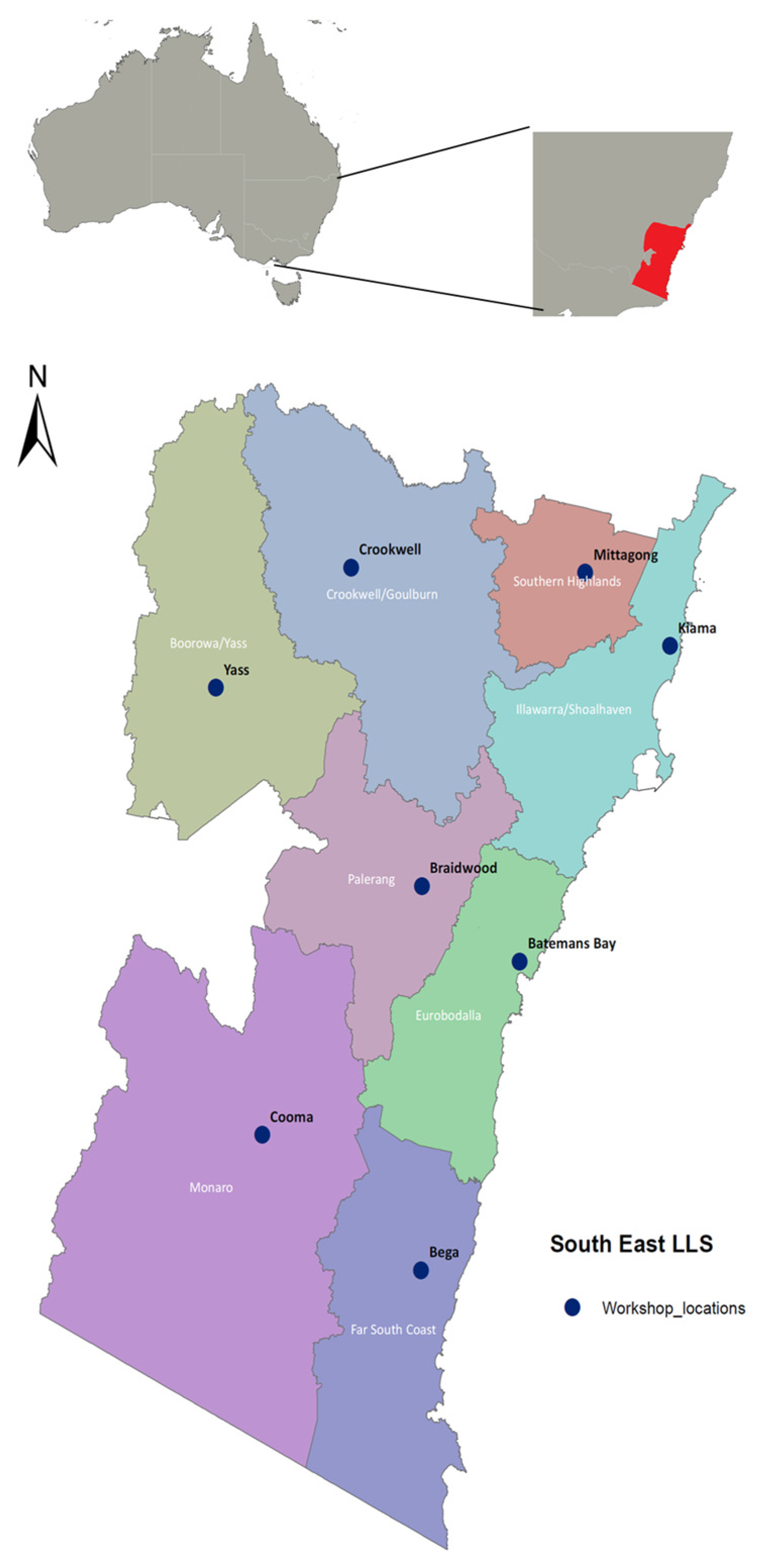
4.1. Place-Based Participatory Workshops

This paper provides a synthesis of the findings from a series of place-based participatory workshops that focused on the management of natural resources for extreme weather events across 8 sub regions of South East NSW, Australia (Figure 4).
The workshops were conducted in 2014 with approximately 100 (in total) community members representing farmers, landholders, emergency service volunteers, local and state government, business owners, Indigenous peoples, financial institutions and Non-Government Organisations (Table 1). Participation was through invitation (by the regional NRM agency) and self-selection, provided two basic criteria were met: (1) participants lived in the landscape under discussion (but not necessarily at the workshop location); and, (2) they were widely networked and able to reflect on issues relating to NRM, extreme event management or the community in general. Meeting these criteria offset the limitations imposed by low numbers of participants at some workshops. In addition, because the same type of extreme event was discussed at different locations (with the exception of storm events) there was considerable redundancy in the data with most themes recurring at multiple workshops. Some workshop participants represented a number of different groups, for example, farmers that are also part of community-based NRM groups or that volunteer with the rural fire management service. Government representatives were also considered as representing their community because they lived and worked in the landscape under discussion. Our approach represents an often necessary compromise in consultation with small rural communities between scientific rigor and the need for relevance to stakeholder concerns; establishment of clear links between activity and impact; ability to capture spatial and temporal context; and resonance with the public to represent society’s concerns and aspirations [36].
The workshops were designed to enable a clearer understanding of the South East region’s vulnerability to climate change and to inform the development of strategies that support the community to build landscape and community resilience to extreme climatic events.

Workshop Process

Qualitative data were collected during facilitated workshop sessions. Two key activities were conducted during each workshop. The first activity was undertaken as an open plenary discussion that utilised the emergency management cycle—Prevent, Prepare, Respond and Recover (PPRR) to frame participant consideration of the most important local hazards—bushfires, drought, storms and flooding under current climate projections (Figure 5). In particular we sought information about the local, lived experience [37] of extreme climate events throughout the emergency management cycle. This discussion was captured directly into a spreadsheet template and the information projected onto a screen to enable real-time clarification by participants.
Key questions for participants at each workshop included:
  • How much time is spent in each phase of the EM cycle?
  • When do the EM cycle phases begin and end?
  • What is most at risk in this landscape?
  • What actions are undertaken by the community (not necessarily NRM focused) during these phases?
The second activity was designed to specifically address the actions taken to manage natural resources and aspects of community capacity to undertake management actions in each phase of the PPRR cycle.
Participants were divided into four groups corresponding to one phase of the cycle. Where possible the expertise of individuals was matched to particular phases of the cycle. For example, rural counsellors and community finance representatives were often assigned to the recovery phase. Within each group a facilitator led an in-depth discussion of current actions to manage natural resources for extreme events, and views on the aspects of the natural environment and local livelihoods and lifestyles that may be lost to the community if extreme events become more frequent or intense. Finally improvements to the management of extreme events throughout the PPRR cycle to better protect the natural resource base were discussed.
These data were recorded in printed A3-sized templates by a facilitator assigned to each discussion group. The qualitative information collected about each stage of the emergency management cycle was coded for workshop location and extreme event type. This information was subjected to qualitative meta-synthesis [38] to identify emergent themes and provide deeper insights than might be possible from studies of a single location or event type [39].

4.2. South East NSW Climate Drivers

To inform the workshops an analysis of the climate drivers and potential hazards faced by communities in the South East was conducted. Information was drawn from historical climate analyses (Australian Bureau of Meteorology) of temperature trends, rainfall trends, anomalies and seasonality, and the occurrence of severe low-pressure systems; and, a climate summary for SE NSW prepared for the SE Integrated Regional Vulnerability Assessment [40] (Table 2).

4.3. Regional Hazard Mapping

A series of maps were developed, using existing state-wide land, soil vegetation and land use data to identify areas that are vulnerable to the impacts of extreme climatic events (Figure 1). Details of the preparation of the maps are provided in Chapman and Barrett [42]. The bushfire hazard map accounted for topographic wind exposure and relative fuel load according to native vegetation formation. The flood hazard map identified flat areas that pool water, soil drainage, rainfall, topographic slope, position and propensity for water logging. The drought map combined dryness/moisture loss with bare soil vulnerability. Bare soil vulnerability was determined as the highest level of bare soil recorded from annual satellite imagery for the 2000–2012 period. This level was used as an indicator of ground cover which would be experienced during an extreme drought under modelled conditions. These maps were then used to initiate discussions with communities, based upon the event or events (drought, bushfire and flooding) that were most likely to affect them.

Acknowledgments

We would like to acknowledge the funding provided by the Australian Government’s NRM Planning for Climate Change Fund and the NSW Adaptation Research Hub. The funds were for the project work only and do not include the costs to publish in open access.

Author Contributions

Brent Jacobs co-designed the workshop activities, facilitated the workshops and analysed the data for a report and this paper. Brent also conducted background research into the topic. Louise Boronyak-Vasco co-designed the workshop activities & facilitated the small group activities as part of the workshops, wrote up the workshop outputs, analysed the data for a report that the paper is based on. Kristy Moyle undertook the background research to generate the hazard maps and the climate projections for the region and reviewed and commented on a report that the paper is based on. She also facilitated the small group activities and organized the workshops. Peat Leith provided input into the design of the workshop activities, facilitated the small group activities at some workshops and reviewed this paper.

Conflicts of Interest

The authors declare no conflict of interest.

Abbreviations

The following abbreviations are used in this manuscript:
EEC
Endangered Ecological Community
EM
Emergency Management
NR
Natural Resources such as soils, water, biodiversity etc.
NRM
Natural Resource Management
NSW
New South Wales
OEH
NSW Office of Environment and Heritage
PPRR
prevent-prepare-respond-recover cycle
RFS
Rural Fire Service
SE
South East region of New South Wales
SES
State Emergency Service

References

  1. Gupta, A.K.; Nair, S.S. Ecosystem Approach to Disaster Risk Reduction; National Institute of Disaster Management: New Delhi, India, 2012; pp. 1–202. [Google Scholar]
  2. Crossman, N.D.; Bryan, B.A. Identifying cost-effective hotspots for restoring natural capital and enhancing landscape multifunctionality. Ecol. Econ. 2009, 68, 654–668. [Google Scholar] [CrossRef]
  3. Kokic, P.; Davidson, A.; Boero Rodriguez, V. Australia’s Grains Industry: Factors Influencing Productivity Growth. Aust. Commod. Forecast. Issues 2006, 13, 705–712. [Google Scholar]
  4. Richardson, K.; Steffen, W.; Liverman, D. (Eds.) Climate Change: Global Risks, Challenges and Decisions; Cambridge University Press: Cambridge, UK, 2013; pp. 1–494.
  5. Bosomworth, K.; Handmer, J. Climate change and community bushfire resilience. In Community Bushfire Safety; Handmer, J., Haynes, K., Eds.; CSIRO: Collingwood, Australia, 2008; pp. 175–183. [Google Scholar]
  6. Breshears, D.D.; López-Hoffman, L.; Graumlich, L.J. When ecosystem services crash: Preparing for big, fast, patchy climate change. Ambio 2011, 40, 256–263. [Google Scholar] [CrossRef] [PubMed]
  7. Intergovernmental Panel on Climate Change (IPCC). Climate Change 2014: Synthesis Report. Contribution of Working Groups I, II and III to the Fifth Assessment Report of the Intergovernmental Panel on Climate Change; Core Writing Team, Pachauri, R.K., Meyer, L.A., Eds.; IPCC: Geneva, Switzerland, 2014; p. 151. [Google Scholar]
  8. Taleb, N.N. The Black Swan: The Impact of the Highly Improbable; Random House: New York, NY, USA, 2007; p. 480. [Google Scholar]
  9. Easterling, D.; Meehl, G.; Parmesan, C.; Changnon, S.; Karl, T.; O’ Mearns, L. Climate Extremes: Observations, Modeling, and Impacts. Science 2000, 289, 2068–2074. [Google Scholar] [CrossRef] [PubMed]
  10. Smith, M.D. An ecological perspective on extreme climatic events: A synthetic definition and framework to guide future research. J. Ecol. 2011, 99, 656–663. [Google Scholar] [CrossRef]
  11. Davidson, D.J. The applicability of the concept of resilience to social systems: Some sources of optimism and nagging doubts. Soc. Nat. Resour. 2010, 23, 1135–1149. [Google Scholar] [CrossRef]
  12. State of New York. New York State Hazard Mitigation Plan; New York State Division of Homeland Security and Emergency Services: New York, NY, USA, 2014; pp. 1–1205. Available online: http://www.dhses.ny.gov/recovery/mitigation/documents/2014-shmp/2014-SHMP-full.pdf (accessed on 29 February 2016).
  13. Public Safety Canada. Emergency Management Planning Guide 2010–2011. Available online: https://www.publicsafety.gc.ca/cnt/rsrcs/pblctns/mrgnc-mngmnt-pnnng/mrgnc-mngmnt-pnnng-eng.pdf (accessed on 2 February 2015).
  14. Sahin, B.; Kapucu, N.; Unlu, A. Perspectives on crisis management in European Union countries: United Kingdom, Spain and Germany. Eur. J. Econ. Political Stud. 2008, 1, 17–37. [Google Scholar]
  15. Government of New South Wales. NSW State Emergency Management Plan (EMPLAN). Available online: https://www.emergency.nsw.gov.au/media/admin/262/_/7a9tjyhcxjh44kw8c8/EMPLAN_20121201.pdf (accessed on 29 February 2016).
  16. McInnes, K.L.; Hubbert, G.D. The impact of eastern Australian cut-off lows on coastal sea levels. Meteorol. Appl. 2001, 8, 229–243. [Google Scholar] [CrossRef]
  17. Boronyak-Vasco, L.; Jacobs, B. Managing natural resources for extreme climate events: Differences in risk perception among urban and rural communities in Sydney, Australia. In Innovation in Climate Change; Filho, W.L., Ed.; Springer International: Cham, Switzerland, 2016; in press. [Google Scholar]
  18. Frandsen, M. Promoting community bushfire preparedness: Bridging the theory–practice divide. Ph.D. Thesis, University of Tasmania, Hobart, Australia, 2012. [Google Scholar]
  19. Leith, P.; Jacobs, B.; Brown, P.R.; Nelson, R. A participatory assessment of NRM capacity to inform policy and practice: Cross-scale evaluation of enabling and constraining factors. Soc. Nat. Resour. 2012, 25, 775–793. [Google Scholar] [CrossRef]
  20. Jacobs, B.C.; Brown, P.R. Drivers of change in landholder capacity to manage natural resources. J. Nat. Resour. Policy Res. 2014, 6, 1–26. [Google Scholar] [CrossRef]
  21. Caldwell, K.; Boyd, C.P. Coping and resilience in farming families affected by drought. Rural Remote Health 2009, 9, 1088. [Google Scholar] [PubMed]
  22. Walker, B.; Salt, D. Resilience Thinking: Sustaining Ecosystems and People in a Changing World; Island Press: Washington, DC, USA, 2006; pp. 1–174. [Google Scholar]
  23. Fritze, J.; Blashki, G.; Burke, S.; Wiseman, J. Climate change and the promotion of mental health and wellbeing. Int. J. Ment. Health Syst. 2008, 2. [Google Scholar] [CrossRef] [PubMed]
  24. Leitch, A.M.; Bohensky, E.L. Return to ‘a new normal’: Discourses of resilience to natural disasters in Australian newspapers 2006–2010. Glob. Environ. Chang. 2014, 26, 14–26. [Google Scholar] [CrossRef]
  25. Nicholls, N. The changing nature of Australian droughts. Clim. Chang. 2004, 63, 323–336. [Google Scholar] [CrossRef]
  26. Kiem, A.S. Drought and water policy in Australia: Challenges for the future illustrated by the issues associated with water trading and climate change adaptation in the Murray–Darling Basin. Glob. Environ. Chang. 2013, 23, 1615–1626. [Google Scholar] [CrossRef]
  27. Nelson, R.; Howden, M.; Smith, M.S. Using adaptive governance to rethink the way science supports Australian drought policy. Environ. Sci. Policy 2008, 11, 588–601. [Google Scholar] [CrossRef]
  28. Nelson, D.R.; Finan, T.J. Praying for drought: Persistent vulnerability and the politics of patronage in Ceará, Northeast Brazil. Am. Anthropol. 2009, 111, 302–316. [Google Scholar] [CrossRef]
  29. Dijk, A.I.; Beck, H.E.; Crosbie, R.S.; Jeu, R.A.; Liu, Y.Y.; Podger, G.M.; Timbal, B.; Viney, N.R. The Millennium Drought in southeast Australia (2001–2009): Natural and human causes and implications for water resources, ecosystems, economy, and society. Water Resour. Res. 2013, 49, 1040–1057. [Google Scholar] [CrossRef]
  30. Walker, B.H.; Abel, N.; Anderies, J.M.; Ryan, P. Resilience, adaptability, and transformability in the Goulburn-Broken Catchment, Australia. Ecol. Soc. 2009, 14, 12. [Google Scholar]
  31. Bardsley, D.K. Limits to adaptation or a second modernity? Responses to climate change risk in the context of failing socio-ecosystems. Environ. Dev. Sustain. 2014, 17, 41–55. [Google Scholar] [CrossRef]
  32. Rickards, L.; Howden, S.M. Transformational adaptation: Agriculture and climate change. Crop Pasture Sci. 2012, 63, 240–250. [Google Scholar] [CrossRef]
  33. Bell, L.W.; Hayes, R.C.; Pembleton, K.G.; Waters, C.M. Opportunities and challenges in Australian grasslands: Pathways to achieve future sustainability and productivity imperatives. Crop Pasture Sci. 2014, 65, 489–507. [Google Scholar] [CrossRef]
  34. Handmer, J.; Hillman, M. Economic and financial recovery from disaster. Aust. J. Emerg. Manag. 2004, 19, 44–50. [Google Scholar]
  35. Hammill, K.; Tasker, L. Vegetation, Fire and Climate Change in the Greater Blue Mountains World Heritage Area; Department of Environment, Climate Change and Water: Sydney, Australia, 2010. [Google Scholar]
  36. Stevenson, M.; Lee, H. Indicators of sustainability as a tool in agricultural development: Partitioning scientific and participatory processes. Int. J. Sustain. Dev. World Ecol. 2001, 8, 57–65. [Google Scholar] [CrossRef]
  37. Lewis-Beck, M.S.; Bryman, A.; Liao, T.F. Encyclopaedia of Social Science Research Methods: Quantitative Research; Sage Publications: Thousand Oaks, CA, USA, 2013. [Google Scholar]
  38. Sandelowski, M.; Voils, C.; Barroso, J. Comparability work and the management of differences in synthesis studies. Soc. Sci. Med. 2007, 64, 236–247. [Google Scholar] [CrossRef] [PubMed]
  39. Major, C.; Savin-Baden, M. Integration of qualitative evidence: Towards construction of academic knowledge on social science and professional fields. Qual. Res. 2011, 11, 645–663. [Google Scholar] [CrossRef]
  40. Jacobs, B.; Lee, C.; O’Toole, D.; Vines, K. Integrated regional vulnerability assessment of government services to climate change. Int. J. Clim. Chang. Strateg. Manag. 2014, 6, 272–295. [Google Scholar] [CrossRef]
  41. New South Wales Office of Environment and Heritage Adapt NSW Web Portal. Available online: http://www.climatechange.environment.nsw.gov.au (accessed on 2 February 2016).
  42. Chapman, G.A.; Barrett, T.W. Project Modelling to Predict Landscape Vulnerability to Climate Extremes in SE NSW. University of New England Technical Report 6/14, Armidale, Australia 2014. Available online: http://naturalresources.intersearch.com.au/naturalresourcesjspui/handle/1/6193 (accessed on 12 May 2016).
Figure 1. Extreme event exposure to (L to R) bushfire, drought and flood for South East NSW.
Resources 05 00020 g001
Figure 2. Theoretical extreme event timeline to illustrate levels of emergency management activity, social assistance activity, community activity and natural resource function in each phase of the emergency management cycle.
Resources 05 00020 g002
Figure 3. Conceptualization of the potential changes in state of built and natural assets through repeated emergency management cycles.
Resources 05 00020 g003
Figure 4. Location of the South East region in Australia and the locations of workshops in eight regional landscapes.
Resources 05 00020 g004
Figure 5. Emergency management cycle (PPRR) and definition of the phases as used in the workshops [17].
Resources 05 00020 g005
Table 1. Community representation at the extreme events workshops.
Community RepresentativesNumber
Community-based NRM—local environmental groups and conservation volunteers36
Farmers and agricultural representatives 25
State Government (environment, agriculture and regional development agencies) and Local Government staff working in emergency or risk management roles22
Emergency Management—paid staff and volunteers10
Property owners not engaged in farming8
Local business owners7
NGO’s-welfare groups, Indigenous representatives 4
Education (Secondary and Tertiary)4
Table 2. A summary of the major climate impacts for the South East NSW.
Hotter
Rainfall shift: likely increase in summer and decrease in winter
Snowfall: likely decrease
Run-off and stream flow: likely decrease in spring & winter, particularly in the west, and an increase during summer
Sea level: virtually certain to continue to rise
Erosion: likely increase on some soils
Coastal agricultural soils: increase in inundation and acidification
Sea Level Rise with increased flooding leading to risk to property and infrastructure on the coast
Changes to natural ecosystems (alpine, low-lying coastal and fire sensitive).
Changes in flora and fauna—possible increased incidence of invasive and pest species
Source: OEH NSW Climate Profile [41].

