Article

Between Consultation and Collaboration: Self-Reported Objectives for 25 Web-Based Geoparticipation Projects in Urban Planning

1
Department of Architecture and Built Environment, Northumbria University, Newcastle upon Tyne NE1 8ST, UK
2
Faculty of Science, Palacky University Olomouc, 779 00 Olomouc, Czech Republic
3
Department of Civil, Environmental and Mechanical Engineering, University of Trento, I-38123 Trento, Italy
4
Department of Urbanism, Faculty of Architecture and the Built Environment, Delft University of Technology, 2628 CD Delft, The Netherlands
*
Author to whom correspondence should be addressed.
ISPRS Int. J. Geo-Inf. 2021, 10(11), 783; https://0-doi-org.brum.beds.ac.uk/10.3390/ijgi10110783
Submission received: 26 August 2021 / Revised: 2 November 2021 / Accepted: 12 November 2021 / Published: 17 November 2021

Abstract

:
Web-based participatory mapping technologies are being increasingly harnessed by local governments to crowdsource local knowledge and engage the public in urban planning policies as a means of increasing the transparency and legitimacy of planning processes and decisions. We refer to these technologies as “geoparticipation”. Current innovations are outpacing research into the use of geoparticipation in participatory planning practices. To address this knowledge gap, this paper investigates the objectives of web-based geoparticipation and uses empirical evidence from online survey responses related to 25 urban planning projects in nine countries across three continents (Europe, North America, and Australia). The survey adopts the objectives of the Spectrum for Public Participation that range from information empowerment, with each category specifying promises about how public input is expected to influence decision-making (IAP2, 2018). Our findings show that geoparticipation can leverage a ‘middle-ground’ of citizen participation by facilitating involvement alongside consultation and/or collaboration. This paper constitutes a pilot study as a step toward more robust and replicable empirical studies for cross-country comparisons. Empowerment (or citizen control) is not yet a normative goal or outcome for web-based geoparticipation. Our evidence also suggests that information is pursued alongside other objectives for citizen participation, and therefore functions not as a “low-hanging fruit” as portrayed in the literature, but rather as a core component of higher intensities of participation.

1. Introduction

City agencies worldwide are increasingly adopting web-based, participatory mapping technologies to support more effective forms of public participation in urban planning [1,2] and to achieve the related advantages gained from the wider public having a better understanding of the issues they face. This will facilitate a broader consensus, shared solutions and increased public trust towards the government [3,4,5]. In this paper, we use the term geoparticipation to denote all participatory planning practices that use digital map-based participatory platforms in the form of Public Participation Geographic Information Systems (PPGIS), as well as similar digital participatory technologies [6,7,8]. Web-based geoparticipation technologies enable users to crowdsource and analyze the contents of maps and geo-tagged inputs in real-time and across spatial scales by facilitating mass citizen participation. Moreover, they contribute to the communication of a wide range of experiential knowledge between city dwellers and professional planners, all of which broadens the evidence base for urban policies [9] and transforms practices in urban planning and local democracy [10,11].
The last two decades have witnessed a surge in platforms, apps and uses of social media that have the potential to support web-based participatory mapping and crowdsourcing geo-tagged information [12]. Therefore, the benefits of geoparticipation constitute aims rather than guarantees, as these are subservient to the design of wider public participation processes in different planning contexts [1,9]. Generally speaking, the use of public participation by city agencies actively frames and structures the scope of planning orientation that citizens can contribute to, and thereby stifles or narrows down planning alternatives rather than broadening their range [13,14]. Despite its potential to facilitate dialogue and active involvement (i.e., “co-production”) between citizens and government, geoparticipation may only enable one-way information flows from planners to citizens (or vice versa) [12,15]. In fact, the question of whether digital participation enables a move beyond informing or consulting citizens as part of the planning process is not yet fully answered [1]. More empirical evidence is thus needed to assess the actual value of digital participatory platforms in urban planning. This includes web-based PPGIS [12,16,17], especially those with links to the UN Sustainable Development Goals (SDGs) agenda, and more specifically to the Indicator 11.3.2: “Proportion of cities with a direct participation structure of civil society in urban planning and management that operates regularly and democratically”.
Nevertheless, it is not the aim of this paper to provide empirical evidence, establish causal connections or provide full representativeness for a large population/sample of cases. This paper aims to provide a better understanding of the objectives linked to the use of web-based geoparticipation in urban planning processes and decisions, with a focus on the perspectives of urban planning professionals The authors are aware that citizens and communities involved in the participatory process may have very different perspectives on and perceptions of the levels of participation and their influence on planning decisions. However, despite being relevant and of extreme interest, citizens’ perspectives lie outside the scope of the current paper and will be the specific focus of future research requiring new and extensive data collection. The overarching research question that guides our work is:
What are the main objectives of planning agencies and professionals using web-based geoparticipation platforms to engage citizens in urban planning?
This paper seeks to explore the variety of perceived and stated objectives of those using geoparticipation to engage citizens in urban planning. We focus on planning agencies’ perceptions of citizens’ roles in the planning process. We are aware that our sample (n = 25) is neither representative nor comprehensive, as new technological applications and projects are continually emerging. Via the optics of various participatory planning projects, settings and national standards, we attempt to present the spectrum of methods and approaches used. Rather than adding yet another ladder or model to those already in existence, we do so by applying the categories of the widely used Spectrum of Public Participation (SPP) provided by the International Association for Public Participation (IAP2) [18].
This paper is based on an international, multilingual survey of urban planners and communication officers who procured web-based mapping tools in 25 urban planning projects across a range of developed countries (Australia, Canada, Czech Republic, Finland, France, the Netherlands, Sweden, the United Kingdom, and the United States). The findings indicate that geoparticipation is predominantly used to engage citizens across the “consult”, “involve” and “collaborate” categories of the SPP, rather than the “inform” and “empower” categories (i.e., the lower and upper end of the spectrum). The insights from this research paper constitute a preliminary step toward formulating good practice recommendations for the use and improved evaluation of geoparticipation in participatory planning. This is in response to identified gaps in knowledge in areas such as: effectiveness in achieving public participation goals [19], the evaluation of outcomes to provide evidence of success [16] and the use of citizen-centric data to inform urban planning [17]. This article is structured as follows. Section 2 provides a theoretical framework for citizen participation in planning and for the increased use of geoparticipation platforms. Section 3 presents the methods used for project selection and data collection in order to examine the objectives of planners and to answer our research question. Section 4 outlines the results, while Section 5 discusses the findings. Conclusions are drawn in Section 6.

2. Origins and Growth of Web-Based Geoparticipation Platforms

2.1. Citizen Participation in Planning

Web-based geoparticipation has strong roots in the participation of citizens in spatial planning, which has been a core and much-debated principle since the 1960s, with seminal publications by Davidoff [20] and Arnstein [21], among others. In her influential work, Arnstein ([21], p. 216) defines citizen participation as “the redistribution of power that enables citizens (...) to be deliberately included in the future (...) in determining how information is shared, goals and policies are set, tax resources are allocated, programs are operated (...).” Fifty years after Arnstein’s publication, the contested nature and value of citizen participation continues to generate significant academic debate [22]. As researchers repeatedly evidence, the conduct and purpose of citizen participation remains the subject of perennial confusion and uncertainty [23,24,25]. The diversity in models of citizen participation occurs for several reasons: its intrinsically complex nature in terms of theoretical and empirical issues [26]; untidy empirical literature [23]; a myriad of tools and methods [12,27]; and the existence of many overlapping concepts which aim at citizen participation (e.g., co-production, co-creation, crowdsourcing, bridging lay and expert knowledge) [10,12,27,28]. Although often overlapping, the diversity in approaches to citizen participation generates a corresponding variety and lack of consensus about what citizen participation actually is (i.e., its nature) or what it should look like in planning (i.e., normative assumptions about its role) [24,25,26]. For the sake of terminological simplicity, we use the terms “citizen participation” and “public participation” interchangeably throughout this paper to denote the process of engaging citizens in participatory urban planning processes initiated or procured by local government agencies. Beyond the terminological diversity around what public participation is, there is a growing body of literature that takes stock of the simultaneous evolutions in planning practices and digital technology in the form of Planning 2.0 practices and “platform urbanism”. These concurrent transformations are underpinned by increasing compatibility (i.e., “interoperability”) between diverse forms of hardware, software and data, as well as by growing experimentation in local policy making [12,24,29].
The related fields of spatial planning, political science and participatory mapping abound with competing models and frameworks for citizen participation (e.g., [30,31,32,33]), some of which explicitly focus on web-based geoparticipation (e.g., [17,34]). In the absence of any unifying definition or standard approach to analyzing citizen participation, we chose to operationalize our analysis of geoparticipation using the Spectrum of Public Participation (SPP). The SPP (Figure 1) is a landmark model produced by the International Association for Public Participation [18], and it is widely used and adapted in urban planning research and practice (e.g., [35]). It comprises five categories that range from “Inform” to “Empower”, each articulated in terms of clearly defined objectives and related promises to the public. With each step along the framework, the public has more influence on processes and actual outcomes (planning decisions), requiring an increase in the delegation of power from planning institutions to the public.
Considering the focus of this paper, the SPP has four advantages over other models (e.g., Arnstein’s ladder of participation) in the assessment of practitioners’ views concerning the objectives of geoparticipation. First, the SPP was specifically designed to “assist practitioners to assess the level of public impact appropriate to projects/initiatives” ([36], p. 34). Second, related to its pragmatic design, the SPP can be said to favor processes/practices over outcomes, with its focus on transparency, legitimacy and inclusion, and its links to related methods and tools [37]. Third, the categories for citizen participation that underpin the SPP are commonly used by local governments to design public participation initiatives. Finally, critical models such as Arnstein’s ladder of participation are more analytical than pragmatic and are thus more difficult to operationalize for data collection purposes [37].
Although it is reportedly popular and readily usable in planning practice, the SPP is also criticized by some practitioners for its impracticality, despite its intended pragmatic focus (e.g., [38,39]). For example, Jones [39] argues that the SPP displays many internal contradictions in terms of categorization. In particular, the Spectrum’s portrayal of “consultation” fails to account for the expected high standards of public consultation in the UK, where the term has a rather different connotation than in other countries. Notwithstanding, the SPP appeared to be a pragmatic choice for us to investigate the use of web-based geoparticipation in urban planning. An example of an adaptation of the SPP by urban planning professionals is the “Levels of Engagement” model developed and adopted by the City of Longmont (CO, USA). The model comprises four levels: “inform”, “consult”, “involve” and “partner”, which support communication about and the facilitation of the city’s citizen participation projects (https://engage.longmontcolorado.gov/welcome-to-engage-longmont) (accessed on 20 June 2020). While the IAP2 Spectrum links objectives and expected levels of influence on decisions, this paper only focuses on self-reported objectives.

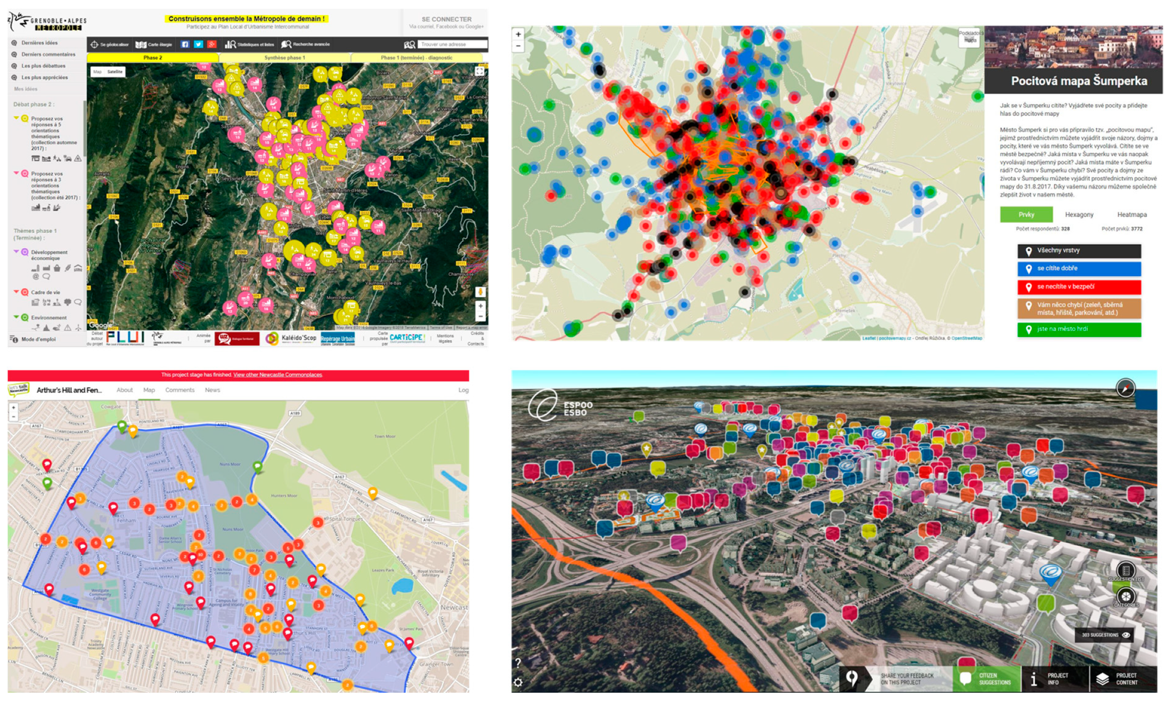
2.2. Web-Based Geoparticipation Platforms

Over the years, technology has played an increasingly important role in participatory planning processes and citizen participation [40], and this is reflected in the increased use of spatial technology and Web 2.0-based mapping tools in planning practice [1,41]. Historically, Public Participation GIS (PPGIS) arose in the late 1990s in contradistinction to elitist, expert-led forms of GIS [42,43,44]. Ever since Robert Chambers [45] stressed the “they can do it” argument in community mapping, web-based geoparticipatory tools have continued to provide a potential means for greater citizen involvement in spatial planning [34,46]. However, participatory mapping processes are diverse and facilitate equally varied forms of citizen participation (see [16,41]). Citizen-led initiatives, such as participatory GIS (PGIS), facilitate community self-organization and independence, both of which differ significantly in their objectives, outcomes and modalities of participation from governmental and institution-led forms of PPGIS [11,34,47]. Distinct from PGIS and PPGIS, volunteered geographic information (VGI) typically refers to cartographic forms of citizen science in such varied contexts as crowdsourcing national geospatial data, environmental monitoring (both active and passive), and disaster management [48,49,50]. This paper focuses on web-based geoparticipation projects initiated by local government agencies in urban planning. Therefore, bottom-up and citizen-driven community maps are beyond the scope of this paper, as is an analysis of the usability of our studied platforms from the citizen perspective. In the absence of any consensual definition, the term geoparticipation encompasses several overlapping concepts. Pánek [7] describes geoparticipation as the use of spatial tools to involve citizens in public participation, utilizing analogue (paper-based) and/or digital maps. He further characterizes geoparticipation as an easy-to-use environment for social engagement that can facilitate feelings of belonging, identification with a place and a sense of community among participants. Zhang [8] differentiates between consultative geoparticipation (e.g., PPGIS or even PGIS) and other forms of participatory mapping that denote active VGI and passive sensor-based geotagged data collection. Gnat et al. [51] elaborate on social geoparticipation even further, stating that urban agglomerations aspiring to become smart cities need to include appropriate geoinformation technologies which enable social (geo)participation. However, this requires not only the use of sophisticated high-tech tools, but also local communities being persuaded to use them. For the purpose of this paper, the authors understand web-based geoparticipation to be an umbrella term for web-based mapping methods and practices for public participation in a wide variety of urban planning contexts. Some approaches mobilize particular specificities to geoparticipation, articulated in terms of the modes of interaction, spatial visualisation and/or deliberation among participants (e.g., PPGIS, geoquestionnaire, argumentation map, 4D PPGIS). Other typologies are more generic and cross-cutting, and may also encompass less active/participatory forms of cartographic crowdsourcing (e.g., geoparticipation as classified by Zhang [8]; visualization tools for dialogue; e-tools to engage citizens). Some typologies can denote both web-based and in-person/paper-based forms of geoparticipation (e.g., PPGIS; geoparticipation as defined by Panek, [7]). Although it often uses web-based participatory mapping tools, sociotope mapping stands out as a technologically agnostic method that surveys the socio-ecological uses of public places and spaces, or “place-values”, as described also by Brown, Reed, and Raymond [52]. Sociotope mapping in particular combines urban residents’ self-reported views about urban and natural landscapes with experts’ observations of residents’ actual uses of these environments [53,54].
A large number of published studies only consider individual or a small number of web-based geoparticipation applications. These usually concern pilot applications in semi-experimental or exploratory settings [55,56,57,58], or one-off applications in a real-world planning context [59,60,61]. Comparative studies have tended to consider a narrow sample of research-based and/or commercially licensed geoparticipation applications, even when reviewing a large number of projects (e.g., [1,6,62]). In order to complement existing empirical comparative studies in the field, this paper contributes a unique and much-needed qualitative insight into the use of a wide range of web-based geoparticipation platforms in urban planning. Particularly, it helps to capture, describe and visualize the diversity of issues that affect the objectives of those using web-based geoparticipation from an international and multi-tool perspective. The paper also advances a synthetic agenda for future research in the form of comparative and longitudinal empirical studies that systematically account for a range of geoparticipation tools, as well as the type and scale of urban planning projects, their locations and duration, and stakeholder perspectives.

3. Methods

3.1. Project Selection

The initial sample used in our research consisted of 150 web-based geoparticipation projects. The sample concerns all the platforms listed in Supplementary S1 (some examples are: Bästa Platsen, Carticipe-Debatomap, CityPlanner, Commonplace, coUrbanize, Emotional Maps, Maptionnaire). The initial sample of 150 projects reflects the number of projects the authors identified that matched the criteria listed below. We adopted a two-tiered purposive sampling strategy. First, we selected relevant web-based geoparticipation platforms (Figure 2) shows four examples based on the following criteria: (i) their use in formal urban planning, typically initiated by local councils/municipalities; (ii) the range of participatory mapping functionalities for citizen participation (e.g., 3D visualization, geoparticipation, ideation, voting, ranking).
Based on our selection of web-based geoparticipation platforms, we drew an initial sample of 150 projects on the basis of the following criteria: (i) a diverse range of spatial planning themes (e.g., green space strategies, transport oriented development, urban regeneration); (ii) a diverse range of planning scales (from the neighborhood level to a council-wide or metropolitan regional level); (iii) a timescale between 2015 and 2018 (i.e., for the web-based geoparticipation project); and (iv) a diverse range of locations. The timescale for citizen participation in the platforms ranged from several weeks to more than a year. The sample of platforms and planning projects illustrates the diversity of technologies and uses in real-life urban planning contexts. The sample is neither representative nor comprehensive, as new technologies, applications and projects are continually emerging. The international distribution of projects and organizations for our initial sample was as follows, respectively: Czech Republic (43 projects at 43 organisations), USA (17 projects at 16 organizations), Australia (16 projects at 7 organizations), France (15 projects at 14 organizations), Sweden (11 projects at 7 organizations), UK (14), Canada (6 projects at 6 organizations), Finland (1 project), Norway (1 project), Luxembourg (1 project).
For all 150 geoparticipation projects in the initial sample, the targeted research participants were expected to be responsible for managing the geoparticipation projects. This information was either explicit from the geoparticipation project websites where individual contact details were publicly provided for the project managers. Alternatively, we contacted a general email or contact form to a planning department or team that was managing the project. All survey respondents were employees at city planning departments and other professional planning organizations. Reminders were sent for a period of up to 6 weeks after sending the initial invitation with the online survey link. We received survey responses between the same day and 8 weeks after sending the initial invitation.
For the Czech Republic, we sent out the invitation to 43 agencies that had used the geoparticipation survey tool Emotional Maps, from whom we received 26 complete, usable responses. Out of the total of 26 responses, we drew a random sample of 4 projects to artificially achieve an approximate geographical distribution evenness relative to the other projects, as requested by peer-reviewers, for 3 out of 6 former versions of this manuscript at 3 separate high-quality (Q1) academic journals. We understand this choice skews the actual response rates to favor a more balanced distribution of projects. We hope to publish a full account of the responses from the Czech Republic in a separate bespoke paper in the near future. Regardless, based on previous studies and reviews (e.g., [12,17,63], the authors see these platforms as indicative of the broader situation of web-based geoparticipation in urban planning.

3.2. Data Collection—Online Survey

To answer the research question for this paper, the data collection consisted of an online survey (see Supplementary S2) that addressed the objectives for citizen participation. Respondents were invited to select the most relevant objectives for web-based geoparticipation. Respondents could select more than one category of objective. Based on the literature review of academic and industry publications, we decided to allow respondents to select many categories, as it is widely acknowledged that public participation processes undergo several phases; they are dynamic rather than static, and tend to move up and down the SPP.
The online survey was distributed between December 2017 and January 2019 via email to individual planning professionals, planning departments and/or local councils/municipalities involved in the identified sample of projects. The publicly-available contact details of respondents were obtained in various ways: online social networks, council websites, public participation summary reports, and previous research contacts. With the aim of getting diverse perspectives as well as contacting the people with first-hand experience of the identified projects, we sent the survey invitation to several planners per project; those who had managed and/or procured the web-based geoparticipation projects. This increased our chances of receiving an answer for every individual project. We contacted 1–3 planning officials for each of the 150 web-based geoparticipation projects (our initial purposive sample) and sent up to three email reminders.
In total, we received 28 survey responses concerning 25 projects (Table 1). Two responses were obtained for 3 projects (Bristol, Täby, and Monash). For ethical reasons the identities of the respondents remain anonymous.
Our modest response rate confirms the general observation that non-response biases are common to online surveys because self-selection results in significant unpredictability in the data collection process [64]. As a result, we were unable to obtain a balanced geographic and platform-based distribution of survey responses as initially hoped for. More relevant projects per geoparticipation platform were also identified for some tools (particularly Social Pinpoint, coUrbanize, Emotional Maps, Commonplace, and Carticipe-Debatomap), compared to others (e.g., Mapping for Change, TransformCity). Notwithstanding, the sample of responses provides data that are barely available elsewhere and valuable insights across a wide range of urban planning projects and locations.

3.3. Data Analysis

The results of the international survey (qualitative research) were analyzed thematically following a social constructionist, interpretivist theory because of the survey’s explicit focus on people’s perceptions of reality [65]. Social constructionism remains attentive to the social production and internalization of institutions and practices among individuals and groups of people, particularly those aspects that are taken for granted.

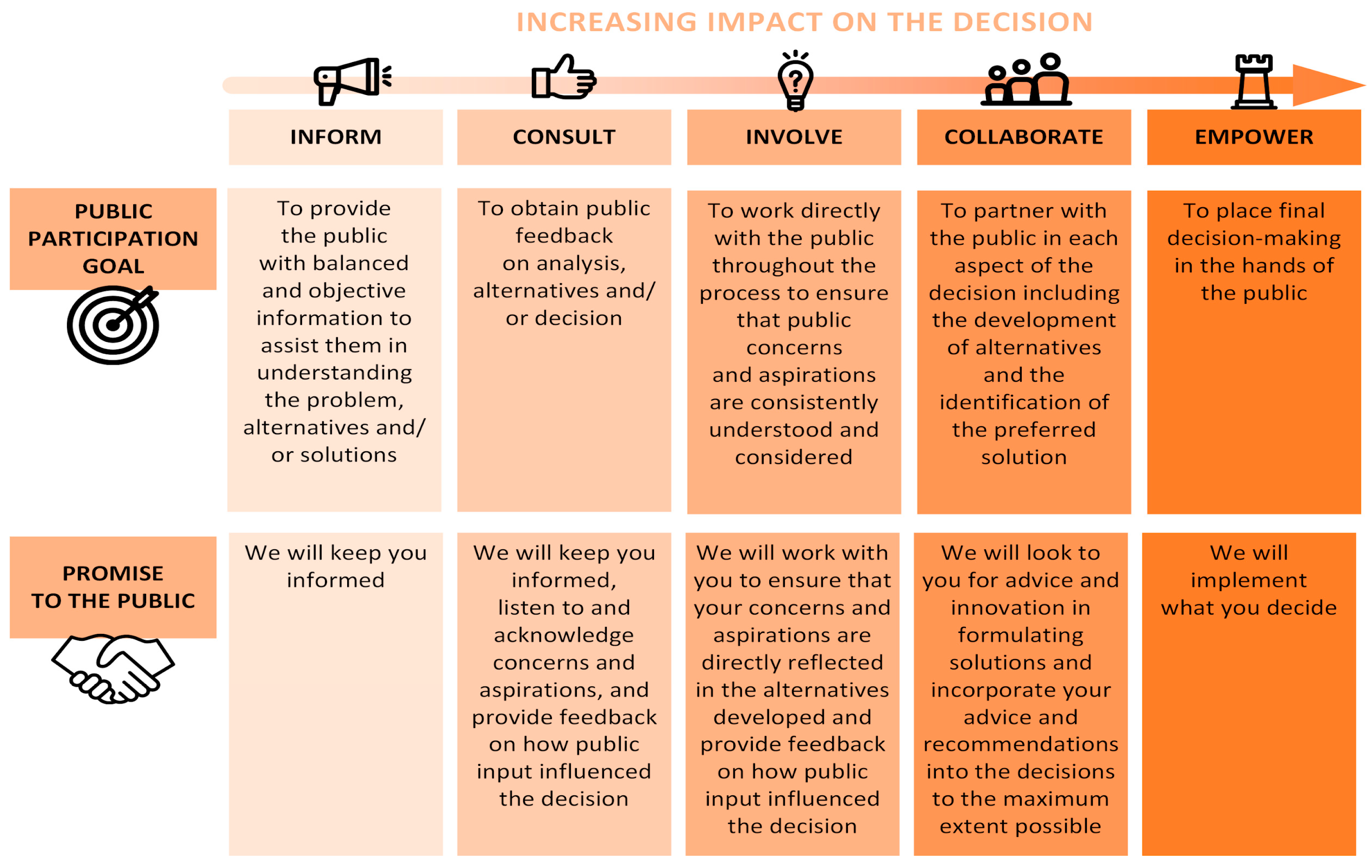
4. Results: The Objectives of Geoparticipation in Urban Planning

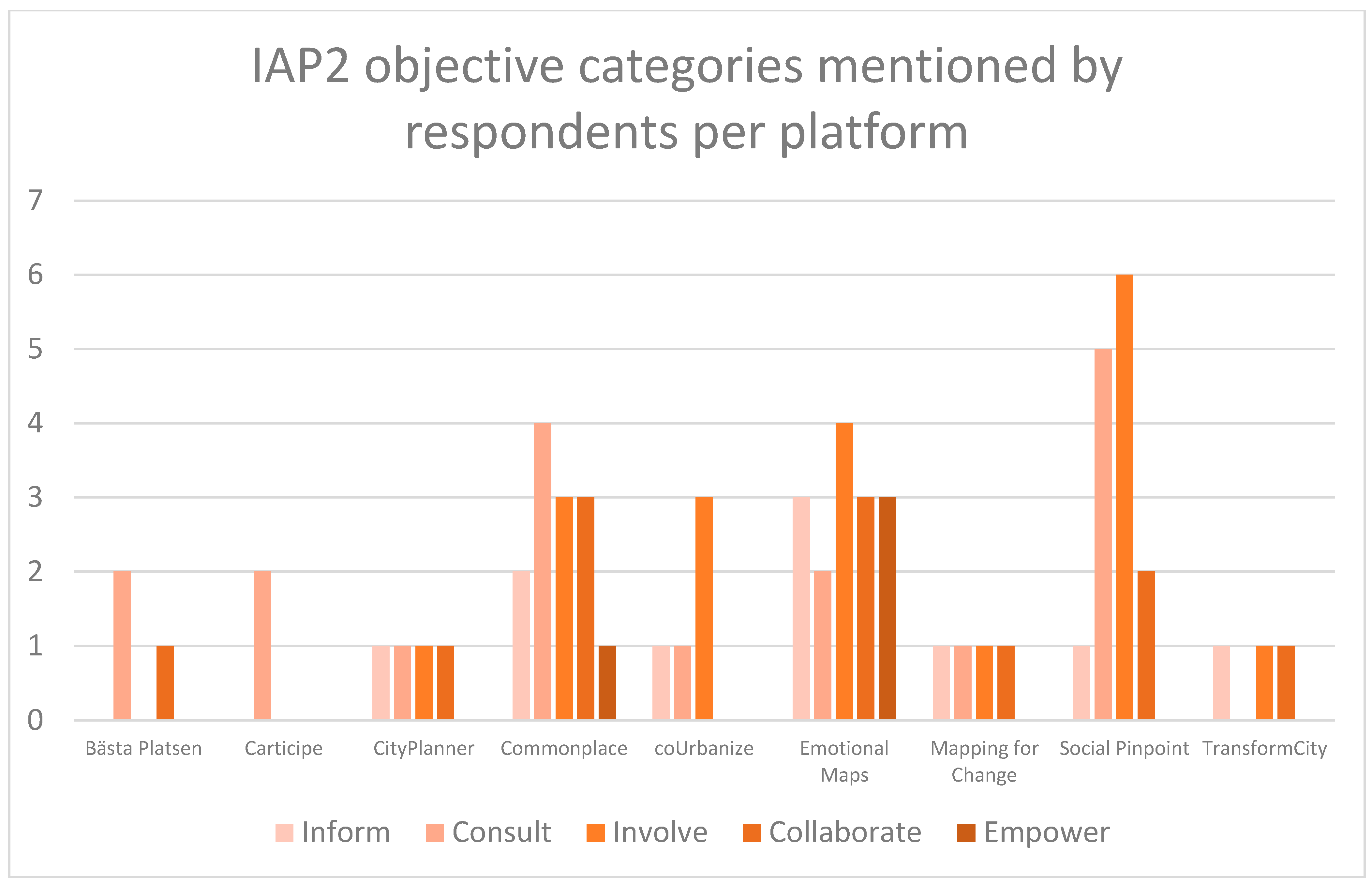
4.1. An Overview of the Main Findings

This paper constitutes a pilot study as a step toward more robust and replicable empirical studies for cross-country comparisons. The main findings provide evidence that web-based geoparticipation projects facilitate a “middle-ground” of citizen participation. In other words, the survey responses from urban planning professionals indicate that while the use of geoparticipation goes beyond simply informing the public about planning projects, it falls short of full empowerment of citizens. Table 2 displays the combined survey responses from all 28 respondents concerning the 25 web-based geoparticipation projects. Respondents selected all the relevant citizen participation categories from the SPP that applied to the public participation project they had managed or procured.
Involvement, consultation and collaboration were the most mentioned public participation objectives, respectively. Half of the respondents (15/28) selected more than one objective for public participation. This indicates that web-based geoparticipation platforms can facilitate several objectives simultaneously as well as single objectives. Across all projects, web-based geoparticipation was also carried out alongside in-person engagement methods. Our analysis of the responses did not reveal any conclusive trends across different types of urban planning projects. We thus structured our findings based on each objective for public participation, instead of per type of urban planning project or project location. For simplicity of presentation, the findings concerning the objectives for web-based geoparticipation are structured as they appear on the SPP (i.e., starting with “Inform” and ending with “Empower”). The findings presented are based on the SPP categories which the respondents selected, rather than on any re-interpretation by the authors. The pragmatic and theoretical implications of the findings are discussed in a separate section after the findings. Figure 3 shows the SPP categories in relation to the web-based participatory mapping platforms used by the planners.

4.2. “Inform”

Respondents referred to the “Inform” category to denote the provision of information to citizens about the planning projects, including related constraints and opportunities for change in the built environment, such as the manner in which citizen input could contribute to shaping planning decisions. For example: “The map allowed us to inform residents by demonstrating the significant challenge in identifying a sufficient number of suitable sites in such a densely populated, highly developed inner-city area. This increased level of awareness makes it easier for residents to understand our decisions, even if they don’t necessarily agree with them (Southwark). Respondents also used the term information to denote one-way communication from citizens to planning organizations. The respondent at Espoo highlighted that the platform did not facilitate dialogue between residents and planners, which was instead facilitated via social media. Reference to the term “information” could also relate to mutual learning among participants, as well as insights from inferred demographics about platform participants: “Helped to inform public of wider issues other to their own pre-held beliefs and demonstrated variances of attitude based on demographics (Bristol). Respondents sometimes used the term information in the open comments, even where they did not select it as an SPP category. These comments denoted the perceived value of the information collected on the geoparticipation platforms. For instance, a respondent in Sweden reported: “Good starting point at the beginning of planning with useful information on which places are valued, how they are used etc. and what one wants to develop in the area (Täby).

4.3. “Consult”

The consultation level denoted the collection of citizens’ views and development preferences about particular places or themes. For most projects, consultation was aimed at collecting baseline data, and this was often one way of confirming planning experts’ prior knowledge, as well as gaining more insight into specific places or planning themes, and identifying patterns such as: the most or least popular places, how places are used, citizen needs and land use preferences, for which geoparticipation was particularly valuable. Another mentioned that the aim of consulting was to improve the legitimacy as well as the overall transparency of the planning process (Newcastle, Espoo). For the Bristol case: “Commonplace allowed the public to list and map their main barriers to walking and cycling locally. These issues then helped our design team focus our approach on interventions that would be more acceptable to the general public.” Interestingly, many of these objectives were also mentioned by respondents who did not select consultation as an objective, but selected involvement and/or collaboration instead. This goes some way to indicate that the nuances between consultation, involvement and collaboration conveyed by the SPP might not be clear for our respondents. Due to their respective experiences and perceptions, the interpretation of differences between consultation, involvement and collaboration seems subjective and might become muddled in actual practice.

4.4. “Involve”

Involving the public was the most common objective for engaging citizens. Nineteen respondents selected this SPP category, of whom three selected it as the only objective. Respondents provided various illustrations of how web-based geoparticipation facilitated involvement. In particular, the intensity of dialogue on the geoparticipation platforms seemed quite contextual. A respondent in the US provided a nuanced assessment of how the tool served the intended objective to support a local plan: “The public has been quite vocal in responding to questionnaires (relative to other methods). Makes it easier for the public to be informed (for better), and easier to comment (for better and worse). [The geoparticipation platform] is a good place for one-way communication, but not that great for two-way conversation.” Another respondent expressed the view that the platform did not provide an effective tool for dialogue: “It would be more practical that you would have possibility to have a conversation about the development projects in the one and same platform. Now this isn’t possible in [the geoparticipation platform] (Espoo)”. Interestingly, the same respondent also referred to the fact that “it’s a common thing that you are expected to increase participation between inhabitants and officials nowadays.” Dialogue emerges as an important component of effective public participation. However, as the sum of our findings indicate, the capacity for geoparticipation to leverage dialogue varies across contexts and planners’ perceptions.
In a similar fashion to the “consultation” category, involvement typically centered around the ability to collect citizens’ views about and suggestions for urban planning projects “The geoparticipation platform] provided a useful tool to allow the public to identify significant transport related issues and encourage solutions to be put forward (Lake Macquarie: Parking Strategy)”. Likewise, “citizens could indicate the places that people appreciate, and the values associated with these places, and development needs. Good to collect views about popular places and which qualities are appreciated (Bristol). The capacity to gather data from more people than was possible with alternative methods of public participation was repeatedly mentioned by the respondents who selected the “involve” and “collaborate” categories. Geoparticipation also enabled to elicit views from the public that would not have been obtained through other means (e.g., Velké Meziříčí).

4.5. “Collaborate”

Twelve respondents selected the “Collaborate” category, of whom ten selected it alongside “Involve” and only two selected it on its own. It transpired that collaboration was a deeper form of involvement, as in those cases where the output of geoparticipation effectively informed urban interventions and/or longer-term planning purposes, for example with traffic and mobility-related issues (Bristol). A respondent in Sweden expressed the view that geoparticipation enabled him/her to perform a perceptions analysis, which would then form the basis for decision-making in guiding the urban planning project.
For a respondent in Australia who selected collaboration as the only objective, the platform fostered dialogue as well as one-way communication: “The geoparticipation platform] gave people the opportunity to contribute constructive ideas framed by themes. It also allowed others to consider and discuss other people’s ideas. It was a first for the [planning agency. People found it very effective and a great way to get involved. The process and method was highly complimented by participants and observers.” This quote also indicates that the nuances between involvement and collaboration conveyed by the SPP may not necessarily come across as clearly in practitioners’ actual experiences. In this instance, the capacity to contribute ideas for urban planning may be perceived as a form of collaboration in its own right. Geoparticipation could also be seen to function as a collaborative platform between different stakeholders while leveraging higher levels of information: “By giving more information and direct connections to other stakeholders there were more people informed and more people collaborated (Amsterdam).

4.6. “Empower”

Empowerment was mentioned in four survey responses, always alongside other SPP categories. A respondent highlighted the effective use of citizen input in the planning process: “We are now at the point where we have a list of priority projects that will be taken to detailed design, which have been directed by community feedback. It has allowed us to gather needs, views and feedback in one place. The analysis tool has been very useful and allows a snapshot during the engagement process, and a final analysis when the engagement is closed (Newcastle). In this instance, on-going decision-making was at least partly shaped by the input on the web-based geoparticipation platform.
Interestingly, the respondents did not necessarily provide strong illustrations of “empowerment” in their responses. A respondent at Monash perceived that appropriate design of citizen participation at large determined the choice of web-based geoparticipation and its effectiveness in engaging citizens: “The key question for every consultation process should first be “what do I wish to find out from the community and what do I need to ask?” From this you would be able to determine what are the best techniques I could employ to obtain that information. Mapping surveys will not always be the answer”.

5. Discussion: Between Consultation and Collaboration

We ground our discussion in a critical pragmatic perspective. The first subsection dwells primarily on the objectives for geoparticipation, whereas the second subsection focuses on its versatility.

5.1. Moving Up the Spectrum?

Our purposive sample of web-based geoparticipation projects shows that web-based geoparticipation can leverage a “middle-ground” of citizen participation across a wide diversity of planning contexts. Given the distribution of responses, we contend that the objectives for web-based geoparticipation are: to pursue involvement, consultation and collaboration, but rarely empowerment, as per the SPP categories. A robust foundation of information and communication helps anchor web-based geoparticipation, as the “inform” SPP category was often mentioned as an essential component of geoparticipation. In the index of geoparticipation [66] consisting of three domains—communication, participation and transparency, communication is often considered less demanding for municipalities than participation and transparency, and it can be in the form of one-way interaction. The findings also show that web-based geoparticipation can facilitate multiple objectives for citizen participation simultaneously. Lastly, our findings concerning the objectives of geoparticipation challenge the assumption that digital technology provides a silver bullet to effective citizen participation. Web-based geoparticipation is an important, albeit insufficient, component for guaranteeing the inclusiveness and transparency of participatory planning processes. It should thus be deployed alongside other methods and tools for public participation [9]. We discuss the implications of each finding sequentially.
Compared to prior studies which showed that web-based geoparticipation and digital participatory tools mainly fostered information and consultation (e.g., [67,68,69,70]), our findings suggest that digital technology in the form of web-based geoparticipation can enable involvement and collaboration as well as lower levels of participation such as information and consultation. The implications of this finding concern the perceived intensity and the different objectives of citizen participation. First, it may be that greater familiarization with digital participatory tools among planning professionals and citizens is leading to the greater use of these tools in urban planning and is facilitating higher intensities of participation, as part of the digital turn in participatory planning practices [71,72]. Some researchers have noted a receding digital divide as urban populations become more acquainted with digital tools, including PPGIS applications [73]. However, empirical academic research is only capturing a glimpse of current web-based geoparticipation and digital participatory practices, as it does not seem to be keeping pace with recent developments [19,46]. While our findings may provide evidence of more intensive forms of citizen participation, it can also be difficult to compare our empirical results based on the SPP with (mainly theoretical) studies that consider communication flow as an indicator of the level of shared decision-making authority, following models such as that provided by [35]. Noteworthy empirical studies which consider a breadth of web-based geoparticipation projects (e.g., [1,6,62]) address the use of web-based geoparticipation in terms of substantive, thematic issues, rather than as models of citizen participation. We are aware that every model of citizen participation comes with inherent limitations (as does the SPP). Researchers seem more inclined to investigate the particulars of web-based geoparticipation (or how “the devil lies in the details”). For example, based on empirical evidence for 200 PPGIS projects in real-life planning cases that adopted the same web-based geoparticipation platform, Kahila-Tani et al. [1] categorize the main opportunities and challenges to improving citizen participation in terms of: (i) the practical and process-based modalities of conducting web-based geoparticipation; (ii) the ability to reach a wide demographic and number of citizens; and (iii) the collection of high quality and varied local knowledge. Few, if any, comparative empirical studies seem to benchmark the objectives of web-based geoparticipation in planning based on the SPP or alternative models of citizen participation. Contrastingly, many theoretical studies do suggest such benchmarking approaches, including compelling research frameworks (e.g., [17,34,63,74]). However, our findings largely support existing studies of how web-based geoparticipation functions as a planning support system [1,9]. By providing an arguably innovative avenue for citizen input in the planning process, web-based geoparticipation allows to tap into the local expertise of urban residents in order to improve decision-making. This capacity for mass, inclusive participation is augmented when the platforms are deployed on a large geographical scale and among diverse demographics. This key objective for web-based geoparticipation of being an aid to decision making can also help reduce observable deficits and deficiencies in public participation within urban planning, with the potential to leverage transparency and trust between urban residents and planning agencies. That said, some of our respondents were skeptical as to whether web-based geoparticipation did indeed help leverage effective participation in planning processes. While general expectations about citizen participation in planning seem to be growing, as part of the concurrent innovations in planning practices and digital technology [29], a web-based geoparticipation platform essentially remains a website. Even as they provide valuable tools or even methods for public participation, innovative digital platforms can give the illusion of participation. Innovations in public participation do not per se carry the guarantee of real, impactful involvement in planning processes or outcomes [14,24]. Geoparticipation is no exception [1,6]. Finally, it almost goes without saying that digital divides continue to limit the effectiveness of web-based geoparticipation as planning support systems (e.g., [53]).

5.2. Multiple Objectives and Versatile Uses

Importantly, our findings suggest that web-based geoparticipation can facilitate many objectives simultaneously. It would seem that models of citizen participation (be they ladders, cubes, matrices or spectrums) favor discrete, mutually exclusive categories at the expense of evaluation approaches that are more porous, dynamic and heuristic (see [74]). The versatile use of web-based geoparticipation platforms reviewed in this paper favors the latter, more dynamic use of geoparticipation over the former. Our respondents indicated that the technological features of the platforms and the participatory processes they enabled contributed to several objectives being met simultaneously. In this regard, a potentially overlooked dimension of web-based geoparticipation concerns “information”, also portrayed as a one-way communication flow between citizens and organizations that sponsor public participation (and vice versa) [25,35]. In the wider literature, one-way communication flow is commonly treated as a form of “tokenistic” citizen participation, or even as a “low hanging fruit”. Given the bad press of shallow participatory planning innovation among critical realists particularly (e.g., [13,14,75]), it is understandable that the information category on the SPP could be treated with suspicion (see [38]). Interestingly, not a single respondent in our study selected the “inform” category on its own. This indicates that information can not only serve as an essential pre-requisite for other forms of citizen participation, but web-based geoparticipation can also leverage information alongside other objectives such as consultation, involvement and collaboration. As [66] indicated, communication seems to be elemental for building a municipality’s geoparticipation and it is the most widely implemented. In other words, “informing” is rarely considered to be a form of participation in itself, but merely an obligatory component of any participatory planning process.
Furthermore, both the literature and our respondents display differences regarding the degree of communication flow which the platforms facilitate, and this should be explained contextually. In particular, two respondents (Espoo, Ashland) held the view that the functionalities for dialogue on the platform were limited, which contrasts with studies such as Kingston [76] and Szarek-Iwaniuk and Senetra [73], which emphasize the potential for geoparticipation to deliver effective dialogue between local government and citizens. Many more of our respondents held the view that geoparticipation enabled them to collect valuable local knowledge from citizens, hence indicating a one-way information flow that would perhaps best match the definition of “consultation” in the SPP, even where respondents reported involvement, collaboration or even empowerment as additional objectives. Our findings also reflect some differences in the literature concerning the real value in terms of dialogue of web-based geoparticipation, as opposed to its potential (cf. [52,77]). The further relates to whether the collection of local knowledge through involvement and collaboration is integrated (see [78]) in both processes and outcomes, for example, through co-production and/or co-creation [12,73]. Interestingly, the dimension of “dialogue” does not even explicitly appear on the IAP2 Spectrum of Public Participation. The spectrum implicitly advocates that input from the public should be clearly integrated in processes and outcomes which should be underpinned by clear communication. Yet, arguably, dialogue is something greater than a bi-directional informational flow. Active forms of dialogue underpin deliberation, negotiation, and conflict mediation [79,80]. Currently, our findings and the literature indicate that web-based geoparticipation, at its best, enables bi-directional communication dialogue. We understand two-way communication to occur when citizens are given the opportunity to provide feedback and ideas to urban planners who then report back to citizens about planning outcomes. This corresponds to what Glass ([81], p. 183) terms “unstructured information-exchange techniques” where “planners have little control over who participates, how many citizens participate, or what type of information is produced. With unstructured techniques citizens are presenting their own particular views, problems, or reactions to planners.” While planners have little control of the content of citizen input, it remains within their remit to shape the frame within which citizens are invited to participate. Active dialogue as a basis for deliberation and conflict resolution can potentially influence how planning situations are framed initially, which is inherently messier and more complex to manage and requires great(-er) skill from planners. Such active forms of dialogue must be deliberately built into the participatory processes from the start, when planners commit to engaging the public in such a way [79]. In the absence of such forms of dialogue, web-based geoparticipation may indeed be hollowed out of its full dialogical and deliberative potential, and geoparticipation may only provide an “illusion”, or simulacre, of participation via a website, as hinted at by one of our respondents. It may also be that web-based geoparticipation, as a participatory method and technology, does not leverage the best medium for active dialogue, and that this should instead be conducted via bespoke participatory methods such as citizen assemblies or panels (see [24]).
In contrast to our findings and the literature on web-based geoparticipation, the related fields of local democratic innovation, participatory planning and even participatory mapping tend to portray both dialogue and problem-solving as indispensable, complementary activities in participatory processes. Depending on the design of the public participation project, dialogue and problem-solving can be conducted sequentially (i.e., one after the other, where an initial phase of dialogue shapes the scope for problem-solving), separately (i.e., through different, discrete public participation projects) or concurrently (i.e., both at the same time, if the participatory methods allow it) (cf. [34,82,83]). Dialogue is a staple feature of Habermasian approaches to participatory planning as well as a non-negotiable pre-condition to “re-enchanting democracy” in local placemaking (see [84]). Deliberation as a specific form of dialogue can especially help to (re-)frame policy situations even before they are problematized [83]. However, the use of prepared maps for problem-solving severely constrains the scope for problem formulation and hence the range of admitted suggestions for problem-solving, as well as limiting dialogue [82]. Indeed, it seems to be nearly impossible to map “outside the map” in the context of public consultations (e.g., [85]) without reverting to “counter-maps” or other forms of participatory mapping (i.e., PGIS) produced by community advocacy groups [47]. The field of participatory mapping is largely characterised by approaches that are primarily top-down, such as PPGIS (e.g., led by the local government) or bottom-up, such as PGIS (e.g., led by groups of citizens, often with the help of activist researchers) [6,47]. Due to a different mode of governance as well as sets of objectives, PGIS practices tend to constitute a separate, distinct field of inquiry that cannot be easily integrated into the kind of web-based geoparticipation cases reviewed in this paper.
The fact that respondents mentioned multiple objectives could also indicate a diversity of interpretations on their part regarding the meaning of the SPP categories in actual practice. The subjectivity and contextual meanings ascribed to the different SPP categories famously generated intense debate among experienced engagement practitioners, as illustrated in Carson [38]. In our study, it was sometimes unclear from the responses how practitioners perceived the differences between consultation, involvement and collaboration, with the boundaries between involvement and collaboration seeming to be quite porous, particularly as these were repeatedly selected together. Our findings beg the following question: To what extent do the practical realities underpinning consultation, involvement and collaboration become muddled up in the minds of planning professionals? This question points to perennial debates in the field (see [38]). This question warrants further dedicated investigation beyond the scope of this paper, for example in the form of longitudinal, multiple, comparative and systematic case studies.

6. Conclusions

City agencies increasingly harness the potentialities of geoparticipation to collect the views and local spatial knowledge of citizens in order to improve the quality and legitimacy of planning processes and outcomes. On the basis of 25 web-based geoparticipation projects in a wide range of urban planning contexts in 9 countries, we provide qualitative insights showing that geoparticipation can leverage a ‘middle-ground’ of citizen participation by facilitating involvement alongside consultation and/or collaboration. Our findings indicate that geoparticipation is predominantly used to engage citizens across the “consult”, “involve” and “collaborate” categories of the SPP, rather than the “inform” and “empower” categories (i.e., the lower and upper end of the spectrum). As a versatile method and technology, web-based geoparticipation can also facilitate multiple objectives for citizen participation simultaneously, as related to the categories on the IAP2 Spectrum of Public Participation. Web-based geoparticipation enables users to collect valuable and varied local knowledge from diverse range of demographics, and it can thereby support greater transparency and participation in participatory urban planning processes. Our data also suggest that information is pursued alongside other objectives for citizen participation, and thus functions not as a “low hanging fruit” as portrayed in the literature, but rather as a core component of higher intensities of participation. However, empowerment (or citizen control) is not yet a normative goal or outcome for web-based geoparticipation, nor does it even seem to be close, given the complex nature of urban planning and representative systems of local democracy. More attention thus needs to be paid to the overall quality of relationships between the local government and citizens (process) rather than to technological issues alone (means). Through its widely recognized capacity to collect valuable local knowledge from urban residents, our study contributes evidence concerning the fact that web-based geoparticipation is an important complement and input to, rather than a substitute for, existing decision-making structures and procedures. This paper constitutes a pilot study as a step toward more robust and replicable empirical studies for cross-country comparisons.
On a critical note, our findings focus on the objectives for using geoparticipation as reported by planning professionals. Our paper does not investigate the actual influence of web-based geoparticipation on urban planning, nor does it analyze how the process is perceived by citizens, as a truly critical pragmatic approach needs to consider the views and experiences of a wide range of stakeholders, particularly those of citizens [86]. Indeed, community views may be at odds with planners’ perspectives [47,87]. Citizens should be invited to respond in their own words as well as in terms related to the categories of the IAP2 SPP. Doing so would limit the filtering of citizens’ views and test the relevance of the Spectrum’s categories for public participation across different cases. In practice, however, a comprehensive assessment of influence may prove difficult to operationalize given the complex, multi-layered, and long-term nature of urban planning and political decision-making processes [1,6]. The same also applies to participatory ICTs more generally [88]. However, recruiting actual participants from real-life planning projects can be an arduous endeavor for various practical and privacy reasons, as opposed to more experimental settings, such as usability testing [58,89]. A critical pragmatic account of web-based geoparticipation platforms therefore requires involving different samples of citizens (see [90,91]) at the same time as the platforms are deployed in real-life planning projects (e.g., [60]). Our findings also show that web-based geoparticipation, while useful, cannot replace other modes of citizen participation. Urban planners, therefore, should be cautious of being digital by default in relation to citizen participation and seek to combine web-based geoparticipation with a range of other participatory tools and methods.
A longitudinal, comparative approach would be required to further assess the integration of web-based geoparticipation tools in planning processes and decisions across various contexts. Toward this end, a new conceptual framework for web-based geoparticipation could be developed that bridges both critical and pragmatic approaches compellingly, as inspired by Davis and Andrew [37]. An elaborate mixed methods research design would enable researchers to draw generalizations as well as in-depth contextual understanding through a larger survey which was combined with a series of case studies. This would constitute an essential step toward the further assessment and benchmarking of the use of web-based geoparticipation in urban planning. The insights gained from our research are the first steps toward formulating good practice recommendations for the use and improved evaluation of geoparticipation in participatory planning.

Supplementary Materials

The following files are available online at https://0-www-mdpi-com.brum.beds.ac.uk/article/10.3390/ijgi10110783/s1. Supplementary S1: List of sampled web-based geoparticipation platforms; Supplementary S2: Survey about digital participatory platforms and public participation.

Author Contributions

Conceptualization, Ian Babelon, Jiří Pánek, Enzo Falco, Reinout Kleinhans and James Charlton; methodology, Ian Babelon, Jiří Pánek, Enzo Falco, Reinout Kleinhans and James Charlton; software, Ian Babelon, Jiří Pánek and Enzo Falco; investigation, Ian Babelon, Jiří Pánek, Enzo Falco, Reinout Kleinhans and James Charlton; data curation, Ian Babelon, Jiří Pánek and Enzo Falco; writing—original draft preparation, Ian Babelon, Jiří Pánek, Enzo Falco, Reinout Kleinhans and James Charlton; writing—review and editing, Ian Babelon, Jiří Pánek, Enzo Falco, Reinout Kleinhans and James Charlton; funding acquisition, Jiří Pánek. All authors have read and agreed to the published version of the manuscript.

Funding

This research was partly funded by Czech Science Foundation, grant number 19-14506S.

Informed Consent Statement

Informed consent was obtained from all subjects involved in the study.

Data Availability Statement

The data presented in this study are available on request from the corresponding author. The data are not publicly available due to privacy reasons.

Conflicts of Interest

The authors declare no conflict of interest.

References

  1. Kahila-Tani, M.; Kytta, M.; Geertman, S. Does Mapping Improve Public Participation? Exploring the Pros and Cons of Using Public Participation GIS in Urban Planning Practices. Landsc. Urban Plan. 2019, 186, 45–55. [Google Scholar] [CrossRef]
  2. Mukherjee, F. Public Participatory {GIS}. Geogr. Compass 2015, 9, 384–394. [Google Scholar] [CrossRef]
  3. Agger, A. Towards Tailor-Made Participation: How to Involve Different Types of Citizens in Participatory Governance. Town Plan. Rev. 2012, 83, 29–45. [Google Scholar] [CrossRef]
  4. Irvin, R.A.; Stansbury, J. Citizen Participation in Decision Making: Is It Worth the Effort? Public Adm. Rev. 2004, 64, 55–65. [Google Scholar] [CrossRef]
  5. Forester, J. The Deliberative Practitioner: Encouraging Participatory Planning Processes; MIT Press: Cambridge, MA, USA, 1999. [Google Scholar]
  6. Brown, G.; Kyttä, M. Key Issues and Research Priorities for Public Participation GIS (PPGIS): A Synthesis Based on Empirical Research. Appl. Geogr. 2014, 46, 122–136. [Google Scholar] [CrossRef]
  7. Pánek, J. From Mental Maps to GeoParticipation. Cartogr. J. 2016, 53, 300–307. [Google Scholar] [CrossRef]
  8. Zhang, S. Public Participation in the Geoweb Era: Defining a Typology for Geo-Participation in Local Governments. Cities 2019, 85, 38–50. [Google Scholar] [CrossRef]
  9. Czepkiewicz, M.; Jankowski, P.; Zwoliński, Z. Geo-Questionnaire: A Spatially Explicit Method for Eliciting Public Preferences, Behavioural Patterns, and Local Knowledge—An Overview. Quaest. Geogr. 2018, 37, 177–190. [Google Scholar] [CrossRef] [Green Version]
  10. Brabham, D.C. Crowdsourcing the Public Participation Process for Planning Projects. Plan. Theory 2009, 8, 242–262. [Google Scholar] [CrossRef]
  11. Falco, E. Digital Community Planning: The Open Source Way to the Top of Arnstein’s Ladder. In Smart Cities and Smart Spaces: Concepts, Methodologies, Tools, and Applications; IGI Global: Hershey, PA, USA, 2016; Volume 5, pp. 1490–1514. [Google Scholar] [CrossRef]
  12. Falco, E.; Kleinhans, R. Digital Participatory Platforms for Co-Production in Urban Development. Int. J. E-Plan. Res. 2018, 7, 52–79. [Google Scholar] [CrossRef] [Green Version]
  13. Rosol, M. Governing Cities through Participation a Foucauldian Analysis of CityPlan Vancouver. Urban Geogr. 2014, 36, 256–276. [Google Scholar] [CrossRef]
  14. Swyngedouw, E. Governance Innovation and the Citizen: The Janus Face of Governance-beyond-the-State. Urban Stud. 2005, 42, 1991–2006. [Google Scholar] [CrossRef]
  15. Nummi, P. Crowdsourcing Local Knowledge with PPGIS and Social Media for Urban Planning to Reveal Intangible Cultural Heritage. Urban Plan. 2018, 3, 100–115. [Google Scholar] [CrossRef]
  16. Brown, G.; Kyttä, M. Key Issues and Priorities in Participatory Mapping: Toward Integration or Increased Specialization? Appl. Geogr. 2018, 95, 1–8. [Google Scholar] [CrossRef]
  17. Hasler, S.; Chenal, J.; Soutter, M. Digital Tools as a Means to Foster Inclusive, Data-Informed Urban Planning. Civ. Eng. Archit. 2017, 5, 230–239. [Google Scholar] [CrossRef]
  18. International Association of Public Participation IAP2 Spectrum of Public Participation. Available online: https://cdn.ymaws.com/www.iap2.org/resource/resmgr/pillars/Spectrum_8.5x11_Print.pdf (accessed on 11 March 2019).
  19. Afzalan, N.; Muller, B. Online Participatory Technologies: Opportunities and Challenges for Enriching Participatory Planning. J. Am. Plan. Assoc. 2018, 84, 162–177. [Google Scholar] [CrossRef]
  20. Davidoff, P. Advocacy and Pluralism in Planning. J. Am. Inst. Plan. 1965, 31, 331–338. [Google Scholar] [CrossRef]
  21. Arnstein, S. A Ladder of Citizen Participation. J. Am. Plan. Assoc. 1969, 35, 216–224. [Google Scholar] [CrossRef] [Green Version]
  22. Slotterback, C.S.; Lauria, M. Building a Foundation for Public Engagement in Planning. J. Am. Plan. Assoc. 2019, 85, 183–187. [Google Scholar] [CrossRef] [Green Version]
  23. Day, D. Citizen Participation in the Planning Process: An Essentially Contested Concept? J. Plan. Lit. 1997, 11, 421–434. [Google Scholar] [CrossRef]
  24. Fung, A. Putting the Public Back into Governance: The Challenges of Citizen Participation and Its Future. Public Adm. Rev. 2015, 75, 513–522. [Google Scholar] [CrossRef]
  25. Rowe, G.; Frewer, L.J. A Typology of Public Engagement Mechanisms. Sci. Technol. Hum. Values 2005, 30, 251–290. [Google Scholar] [CrossRef]
  26. Fagence, M. Introduction to The Political Philosophy of Democracy and Participation. In Citizen Participation in Planning; Elsevier: Amsterdam, The Netherlands, 1977; pp. 17–19. [Google Scholar]
  27. Lember, V.; Brandsen, T.; Tõnurist, P. The Potential Impacts of Digital Technologies on Co-Production and Co-Creation. Public Manag. Rev. 2019, 21, 1665–1686. [Google Scholar] [CrossRef] [Green Version]
  28. Rantanen, H.; Kahila, M. The SoftGIS Approach to Local Knowledge. J. Environ. Manag. 2009, 90, 1981–1990. [Google Scholar] [CrossRef] [PubMed]
  29. Anttiroiko, A.-V. Digital Urban Planning Platforms. Int. J. E-Plan. Res. 2021, 10, 35–49. [Google Scholar] [CrossRef]
  30. Connor, D.M. A New Ladder of Citizen Participation. Natl. Civ. Rev. 1988, 77, 249–257. [Google Scholar] [CrossRef]
  31. Fung, A. Varieties of Participation in Complex Governance. Public Adm. Rev. 2006, 66, 66–75. [Google Scholar] [CrossRef]
  32. Hurlbert, M.; Gupta, J. The Split Ladder of Participation: A Diagnostic, Strategic, and Evaluation Tool to Assess When Participation Is Necessary. Environ. Sci. Policy 2015, 50, 100–113. [Google Scholar] [CrossRef]
  33. Rocha, E.M. A Ladder of Empowerment. J. Plan. Educ. Res. 1997, 17, 31–44. [Google Scholar] [CrossRef]
  34. Møller, M.S.; Olafsson, A.S. The Use of E-Tools to Engage Citizens in Urban Green Infrastructure Governance: Where Do We Stand and Where Are We Going? Sustainability 2018, 10, 3513. [Google Scholar] [CrossRef] [Green Version]
  35. Nabatchi, T. Putting the Public Back in Public Values Research: Designing Participation to Identify and Respond to Values. Public Adm. Rev. 2012, 72, 699–708. [Google Scholar] [CrossRef]
  36. IAP2. 2002 Year—End Report. 2002. Available online: https://cdn.ymaws.com/www.iap2.org/resource/resmgr/annual_reports/02annualreport.pdf (accessed on 11 November 2021).
  37. Davis, A.; Andrew, J. From Rationalism to Critical Pragmatism: Revisiting Arnstein’s Ladder of Public Participation in Co-Creation and Consultation. In Proceedings of the 8th State of Australian Cities National Conference, Adelaide, Australia, 28–30 November 2017. [Google Scholar]
  38. Carson, L. The IAP2 Spectrum: Larry Susskind in Conversation with IAP2 Members. Int. J. Public Particip. 2008, 2, 67–84. [Google Scholar]
  39. Jones, R. Beware a Wholly Inadequate Definition of ‘Consultation’—The Consultation Institute. Available online: https://www.consultationinstitute.org/beware-wholly-inadequate-definition-consultation/ (accessed on 5 May 2021).
  40. Anttiroiko, A.-V. The Role of New Technologies in Reshaping Governance Platforms. Int. J. Inf. Commun. Technol. Hum. Dev. 2012, 4, 1–13. [Google Scholar] [CrossRef] [Green Version]
  41. Haklay, M.; Jankowski, P.; Zwoliński, Z. Selected Modern Methods and Tools for Public Participation in Urban Planning—A Review. Quaest. Geogr. 2018, 37, 127–149. [Google Scholar] [CrossRef] [Green Version]
  42. Kingston, R.; Carver, S.; Evans, A.; Turton, I. Web-Based Public Participation Geographical Information Systems: An Aid to Local Environmental Decision-Making. Comput. Environ. Urban Syst. 2000, 24, 109–125. [Google Scholar] [CrossRef]
  43. Obermeyer, N. PPGIS: The Evolution of Public Participation GIS. Cartogr. Geogr. Inf. Sci. 1998, 25, 65–66. [Google Scholar]
  44. Sieber, R. Public Participation Geographic Information Systems: A Literature Review and Framework. Ann. Assoc. Am. Geogr. 2006, 96, 491–507. [Google Scholar] [CrossRef]
  45. Chambers, R. Participatory Mapping and Geographic Information Systems: Whose Map? Who Is Empowered and Who Disempowered? Who Gains and Who Loses? Electron. J. Inf. Syst. Dev. Ctries. 2006, 25, 1–11. [Google Scholar] [CrossRef] [Green Version]
  46. Marzouki, A.; Lafrance, F.; Daniel, S.; Mellouli, S. The Relevance of Geovisualization in Citizen Participation Processes. In Proceedings of the 18th Annual International Conference on Digital Government Research, Staten Island, NY, USA, 7–9 June 2017. [Google Scholar]
  47. Radil, S.M.; Anderson, M.B. Rethinking PGIS: Participatory or (Post)Political GIS? Prog. Hum. Geogr. 2018, 43, 195–213. [Google Scholar] [CrossRef]
  48. Elwood, S.; Goodchild, M.F.; Sui, D.Z. Researching Volunteered Geographic Information: Spatial Data, Geographic Research, and New Social Practice. Ann. Assoc. Am. Geogr. 2012, 102, 571–590. [Google Scholar] [CrossRef]
  49. Goodchild, M. NeoGeography and the Nature of Geographic Expertise. J. Locat. Based Serv. 2009, 3, 82–96. [Google Scholar] [CrossRef]
  50. Yudono, A. Towards Democracy in Spatial Planning through Spatial Information Built by Communities: The Investigation of Spatial Information Built by Citizens from Participatory Mapping to Volunteered Geographic Information in Indonesia. IOP Conf. Ser. Earth Environ. Sci. 2017, 70, 12002. [Google Scholar] [CrossRef] [Green Version]
  51. Gnat, M.; Leszek, K.; Olszewski, R. The Use of Geoinformation Technology, Augmented Reality and Gamification in the Urban Modeling Process. In Computational Science and Its Applications—ICCSA 2016; Lecture Notes in Computer Science; Springer: Cham, Switzerland, 2016; Volume 9787, pp. 484–496. [Google Scholar]
  52. Brown, G.; Reed, P.; Raymond, C.M. Mapping Place Values: 10 Lessons from Two Decades of Public Participation GIS Empirical Research. Appl. Geogr. 2020, 116, 102156. [Google Scholar] [CrossRef]
  53. Łaszkiewicz, E.; Czembrowski, P.; Kronenberg, J. Creating a Map of the Social Functions of Urban Green Spaces in a City with Poor Availability of Spatial Data: A Sociotope for Lodz. Land 2020, 9, 183. [Google Scholar] [CrossRef]
  54. Ståhle, A. Sociotope Mapping-Exploring Public Open Space and Its Multiple Use Values in Urban and Land-Scape Planning Practice. Nord. J. Archit. Res. 2006, 19, 59–71. [Google Scholar]
  55. Butt, M.A.; Li, S. Usability Evaluation of Collaborative PPGIS-GeoCWMI for Supporting Public Participation during Municipal Planning and Management Services. Appl. Geomat. 2014, 7, 139–161. [Google Scholar] [CrossRef]
  56. Czepkiewicz, M.; Jankowski, P.; Młodkowski, M. Geo-Questionnaires in Urban Planning: Recruitment Methods, Participant Engagement, and Data Quality. Cartogr. Geogr. Inf. Sci. 2016, 44, 551–567. [Google Scholar] [CrossRef]
  57. Johansson, T.; Hartmann, T.; Jongeling, R.; Olofsson, T. Development of 4D Public Participation GIS to Improve Communication of City Transformation Processes. In Proceedings of the Construction Research Congress, West Lafayette, IN, USA, 21–23 May 2012; American Society of Civil Engineers: New York, NY, USA, 2012. [Google Scholar]
  58. Wu, H.; He, Z.; Gong, J. A Virtual Globe-Based 3D Visualization and Interactive Framework for Public Participation in Urban Planning Processes. Comput. Environ. Urban Syst. 2010, 34, 291–298. [Google Scholar] [CrossRef]
  59. Bugs, G.; Granell, C.; Fonts, O.; Huerta, J.; Painho, M. An Assessment of Public Participation {GIS} and Web 2.0 Technologies in Urban Planning Practice in Canela, Brazil. Cities 2010, 27, 172–181. [Google Scholar] [CrossRef]
  60. Meng, Y.; Malczewski, J. Usability Evaluation for a Web-Based Public Participatory GIS: A Case Study in Canmore, Alberta. Cybergeo 2009, 483, 1–19. [Google Scholar] [CrossRef]
  61. Poplin, A. Playful Public Participation in Urban Planning: A Case Study for Online Serious Games. Comput. Environ. Urban Syst. 2012, 36, 195–206. [Google Scholar] [CrossRef]
  62. Sieber, R.E.; Robinson, P.J.; Johnson, P.A.; Corbett, J.M. Doing Public Participation on the Geospatial Web. Ann. Am. Assoc. Geogr. 2016, 106, 1030–1046. [Google Scholar] [CrossRef]
  63. Gün, A.; Demir, Y.; Pak, B. Urban Design Empowerment through ICT-Based Platforms in Europe. Int. J. Urban Sci. 2019, 24, 189–215. [Google Scholar] [CrossRef]
  64. Bethlehem, J. Selection Bias in Web Surveys. Int. Stat. Rev. 2010, 78, 161–188. [Google Scholar] [CrossRef]
  65. Rose, D.M.; Berger, P.L.; Luckmann, T. The Social Construction of Reality. Mod. Lang. J. 1967, 51, 307. [Google Scholar] [CrossRef] [Green Version]
  66. Pánek, J.; Pásztó, V.; Burian, J.; Bakule, J.; Lysek, J. What Is the Current State of Geoparticipation in Czech Municipalities? GeoScape 2021, 16, 90–103. [Google Scholar] [CrossRef]
  67. Desouza, K.C.; Bhagwatwar, A. Technology-Enabled Participatory Platforms for Civic Engagement: The Case of U.S. Cities. J. Urban Technol. 2014, 21, 25–50. [Google Scholar] [CrossRef]
  68. Ertiö, T.-P. Participatory Apps for Urban Planning—Space for Improvement. Plan. Pract. Res. 2015, 30, 303–321. [Google Scholar] [CrossRef]
  69. Kahila-Tani, M.; Broberg, A.; Kyttä, M.; Tyger, T. Let the Citizens Map—Public Participation GIS as a Planning Support System in the Helsinki Master Plan Process. Plan. Pract. Res. 2015, 31, 195–214. [Google Scholar] [CrossRef]
  70. Williamson, W.; Parolin, B. Review of Web-Based Communications for Town Planning in Local Government. J. Urban Technol. 2012, 19, 43–63. [Google Scholar] [CrossRef]
  71. Anttiroiko, A.-V. Urban Planning 2.0. Int. J. E-Plan. Res. 2012, 1, 16–30. [Google Scholar] [CrossRef]
  72. Potts, R. Is a New ‘Planning 3.0’ Paradigm Emerging? Exploring the Relationship between Digital Technologies and Planning Theory and Practice. Plan. Theory Pract. 2020, 21, 272–289. [Google Scholar] [CrossRef]
  73. Szarek-Iwaniuk, P.; Senetra, A. Access to ICT in Poland and the Co-Creation of Urban Space in the Process of Modern Social Participation in a Smart City—A Case Study. Sustainability 2020, 12, 2136. [Google Scholar] [CrossRef] [Green Version]
  74. Schlossberg, M.; Shuford, E. Delineating “Public” and “Participation” in PPGIS. Urisa J. 2005, 16. [Google Scholar]
  75. Allmendinger, P.; Tewdwr-Jones, M. The Communicative Turn in Urban Planning: Unravelling Paradigmatic, Imperialistic and Moralistic Dimensions. Space Polity 2002, 6, 5–24. [Google Scholar] [CrossRef]
  76. Kingston, R. The Role of E-Government and Public Participation in the Planning Process. In Proceedings of the XVI AESOP Congress, Volos, Greece, 10–15 July 2002; pp. 1–14. [Google Scholar]
  77. Pánek, J.; Glass, M.R.; Marek, L. Evaluating a Gentrifying Neighborhood’s Changing Sense of Place Using Participatory Mapping. Cities 2020, 102, 102723. [Google Scholar] [CrossRef]
  78. Senbel, M.; Church, S.P. Design Empowerment. J. Plan. Educ. Res. 2011, 31, 423–437. [Google Scholar] [CrossRef]
  79. Forester, J. Making Participation Work When Interests Conflict: Moving from Facilitating Dialogue and Moderating Debate to Mediating Negotiations. J. Am. Plan. Assoc. 2006, 72, 447–456. [Google Scholar] [CrossRef]
  80. Forester, J. On the Theory and Practice of Critical Pragmatism: Deliberative Practice and Creative Negotiations. Plan. Theory 2012, 12, 5–22. [Google Scholar] [CrossRef]
  81. Glass, J.J. Citizen Participation in Planning: The Relationship between Objectives and Techniques. J. Am. Plan. Assoc. 1979, 45, 180–189. [Google Scholar] [CrossRef]
  82. Ramsey, K. GIS, Modeling, and Politics: On the Tensions of Collaborative Decision Support. J. Environ. Manag. 2009, 90, 1972–1980. [Google Scholar] [CrossRef] [PubMed]
  83. Hildreth, R.W. Word and Deed: A Deweyan Integration of Deliberative and Participatory Democracy. New Political Sci. 2012, 34, 295–320. [Google Scholar] [CrossRef]
  84. Healey, P. Re-Enchanting Democracy as a Mode of Governance. Crit. Policy Stud. 2012, 6, 19–39. [Google Scholar] [CrossRef]
  85. Van Herzele, A.; van Woerkum, C. On the Argumentative Work of Map-Based Visualisation. Landsc. Urban Plan. 2011, 100, 396–399. [Google Scholar] [CrossRef]
  86. Kotus, J.; Rzeszewski, M. Online Mapping Platforms: Between Citizen-Oriented and Research-Focused Tools of Participation? J. Plan. Educ. Res. 2020, OnlineFirst, 0739456X2090309. [Google Scholar] [CrossRef]
  87. Brown, G.; Chin, S.Y.W. Assessing the Effectiveness of Public Participation in Neighbourhood Planning. Plan. Pract. Res. 2013, 28, 563–588. [Google Scholar] [CrossRef]
  88. Stempeck, M.; Sifry, M.L. The Problem with Impact Measurement in Civic Tech. In Proceedings of the TICTeC 2018, Lisbon, Portugal, 18–19 April 2018. [Google Scholar]
  89. Rzeszewski, M.; Kotus, J. Usability and Usefulness of Internet Mapping Platforms in Participatory Spatial Planning. Appl. Geogr. 2019, 103, 56–69. [Google Scholar] [CrossRef]
  90. Brown, G.; Fagerholm, N. Empirical PPGIS/PGIS Mapping of Ecosystem Services: A Review and Evaluation. Ecosyst. Serv. 2015, 13, 119–133. [Google Scholar] [CrossRef]
  91. Brown, G.; Kelly, M.; Whitall, D. Which ‘public’? Sampling Effects in Public Participation GIS (PPGIS) and Volunteered Geographic Information (VGI) Systems for Public Lands Management. J. Environ. Plan. Manag. 2013, 57, 190–214. [Google Scholar] [CrossRef]
Figure 1. The Spectrum of Public Participation, adapted with permission from the International Association for Public Participation (Source: www.iap2.org, accessed on 9 October 2021, adapted by the Authors).
Ijgi 10 00783 g001
Figure 2. Screenshots of geoparticipation platforms. (Top left): Carticipe-Debatomap (Grenoble Metropolitan Agency, France); (Top right): Emotional Maps (City of Šumperk, Czech Republic); (Bottom left): Commonplace (Newcastle City Council, UK); (Bottom right): CityPlanner (City of Espoo). Picture credits: courtesy of the platform providers.
Ijgi 10 00783 g002
Figure 3. The division of IAP2 objective categories mentioned in our survey by respondents using various platforms.
Ijgi 10 00783 g003
Table 1. List of the 25 reviewed web-based geoparticipation projects.
City/Client OrganisationRespondent Role(s)CountryWBG PlatformName of Geo-Participation ProjectFocusProject Year
Täby municipalityUrban planner Comms officerSwedenBästa PlatsenTyck till om centrala TäbyUrban regeneration2015–2016
City of ÖrebroEnvironmental PlannerSwedenBästa PlatsenTyck till om Örebros grönområdenParks & recreation2016
Tour Metropolitan RegionEnvironmental OfficerFranceCarticipe-DebatomapEnvies de LoireWaterfront development 2017
City of SherbrookeTouristic development managerCanadaCarticipe-DebatomapDestination SherbrookeTouristic development2015
Grenoble Metropolitan RegionEngagement officerFranceCarticipe-DebatomapPLUi Grenoble MétropoleMetropolitan plan2016–2018
City of EspooPlanning officerFinlandCityplannerTehtävä LeppävaarassaDistrict zoning & development2016–2017
Newcastle City CouncilEngagement officerUnited KingdomCommonplaceStreets for People Active mobility infrastructure2016
S. Oxfordshire & VoWH CouncilsProject officerUnited KingdomCommonplaceDidcot Garden TownMasterplan2017
Bristol City CouncilProject manager Communications officer United KingdomCommonplaceEaston Priority Safer StreetsActive mobility infrastructure2017
Town of Ashland (MA)Assistant Town plannerUSACoUrbanizeAshland Downtown Planning InitiativeLocal plan2017
Town of TewskburyAssistant Town managerUSACoUrbanizeTewksbury Community Vision ProjectVision plan2017
Metropolitan Transport Authority (MARTA)Transport plannerUSACoUrbanizeEast Lake StationTransport planning & neighborhood revitalization2017
London Borough of SouthwarkProject managerUnited KingdomMapping for Change11,000 HomesSocial housing development2015
City of MonashStrategic planners x 2AustraliaSocial PinpointDraft Monash Open Space StrategyOpen Space2017
City of Ballarat- VicRoads AgencyEngagement officerAustraliaSocial PinpointVicRoads MordiallocTraffic2017
Lake Macquarie City CouncilStrategic plannerAustraliaSocial PinpointWarners BayMasterplan, Local plan2015
Lake Macquarie City CouncilUrban economistAustraliaSocial PinpointParking StrategyTransport2016
City Renewal Authority, ACT GovEngagement managerAustraliaSocial PinpointHaig Park MasterplanMasterplan, Local plan2018
City of TorontoAssistant plannerCanadaSocial PinpointCommunity Building at Don Mills & EglintonActive mobility, Parks & recreation2017
City of CalgarySubject expertCanadaSocial PinpointBeddington HeightsParks & Recreation2015–2016
City of Velké MeziříčíConsultantCzech RepublicEmotional MapsHealthy City ForumUrban safety and well-being2015
City of Šumperk Senior plannerCzech RepublicEmotional MapsLocal planUrban safety and well-being2017
City of OrlováProject coordinatorCzech RepublicEmotional MapsLocal Agenda 21Urban safety and well-being2017
City of JilemniceSenior plannerCzech RepublicEmotional MapsLocal Agenda 21Urban safety and attractiveness2016
Amsterdam, Amstel III Development PlanProject managerThe NetherlandsTransformCityAmstel IIINeighborhood development plan2018
Table 2. Number of mentions of the different SPP categories [18] by the online survey respondents (n = 28, concerning 25 geoparticipation projects).
ObjectiveInformConsultInvolveCollaborateEmpower
Totals101819124
Publisher’s Note: MDPI stays neutral with regard to jurisdictional claims in published maps and institutional affiliations.

