Article

Learning from the Informality. Using GIS Tools to Analyze the Structure of Autopoietic Urban Systems in the “Smart Perspective”

by
Valerio Di Pinto
1,
Antonio M. Rinaldi
2,3,* and
Francesco Rossini
4
1
Dipartimento di Ingegneria Civile, Edile e Ambientale, Università di Napoli Federico II, Via Claudio, 21, 80125 Naples, Italy
2
Dipartimento di Ingegneria Elettrica e delle Tecnologie dell’Informazione, Università di Napoli Federico II, Via Claudio, 21, 80125 Naples, Italy
3
IKNOS-LAB—Intelligent and Knowledge Systems—LUPT, Università di Napoli Federico II, Via Toledo, 402, 80134 Naples, Italy
4
School of Architecture, The Chinese University of Hong Kong (CUHK), Lee Shau Kee Architecture Building, Sha Tin, Hong Kong
*
Author to whom correspondence should be addressed.
ISPRS Int. J. Geo-Inf. 2021, 10(4), 202; https://0-doi-org.brum.beds.ac.uk/10.3390/ijgi10040202
Submission received: 27 January 2021 / Revised: 18 March 2021 / Accepted: 22 March 2021 / Published: 25 March 2021
(This article belongs to the Special Issue Geo-Information Science in Planning and Development of Smart Cities)

Abstract

:
This paper explores the link between the current vision of the “smart city” and the notion of urban autopoiesis understood as self-organized/managed urban systems. It seeks to highlight how the use of GIS analysis, applied to the study of informal settlements, can provide useful information to understand the smart city paradigm. The paper argues the key idea that a smart city should not be seen only as a high-tech urban environment because the transition to smartness will need major changes in its inner structure. Using a combination of quantitative and qualitative GIS analysis methods, this study examines the case of the BaSECo Compound, one of the densest informal settlements in Metro Manila (Philippines), with the aim of both generating a comprehensive morphological analysis of this dynamic urban area as well as contributing to the configurational theory of the smart city. The results suggest that the analysis of autopoietic urban systems could expand our understanding of how the structure of the city could evolve to accommodate the needs of its citizens and creating more resilient and inclusive communities.

1. Introduction

Could the understanding of the mechanisms of urban autopoiesis contribute to redefining the concept of the smart city? Informal settlements are unique self-organized urban systems that can provide an alternative perspective to this question. They can be seen as living laboratories where the needs and requirements of the community can be expressed more easily and clearly. By studying the BaSECo compound, this article aims to contribute to the on-going debate about the smart city, describing the key properties of autopoietic urban systems in terms of configurational centrality indexes within the GIS environment.
According to Albino, Berardi, and Dangelico [1], a comprehensive and univocal definition of “smart city” could not be formulated; however, in the last decade, three major research directions can be identified [2]. The first group of research outlines the smart city focusing on aspects such as governance [3], urban policies [4], urban planning [5], and sustainability [6]. The second group is focused on constitutive aspects and the set of devices such as the Internet of Things and their interactions. Specific approaches, which range from sensor technology [7,8] to sensor networks [9], aim to understand how humans interact with these technological devices and systems [10]. The third approach is based on developing organizational models of components and operations, and generally refers to models for layers [10,11,12]. Furthermore, there are examples of conceptual models that have developed methods to study the socio-spatial elements of the city through systems that collect and analyze events intended as changes in the state of an IT system [13].
In all these studies and models, the smart city is understood almost exclusively in its “technological” or “socio-technological” nature, however, just a few studies have analyzed comprehensively its spatial components which, as demonstrated, have a significant influence on the urban environment. Summarizing, the development of an adequate union between man and technology that guarantees the innate qualities of flexibility and justifies a paradigm shift in the concept of the city appears to be decisive for scientific research.
The self-organization model observed in informal settlements directly influences their spatial and social dynamics contributing to create an adaptable and flexible space that is more resilient than the so-called formal city. Informal communities are modeled on the residents needs, and it can be argued that their adaptability and flexibility are key elements for the development of a smart urban environment.
The self-organization of the space depends on how the urban structure and its spatial components are created over time, transformed, and functionally re-organized. In this sense, an urban area can be defined as “autopoietic” when its metabolism is strictly related to the citizens’ needs and requirements [14].
The autopoietic city, however, is still a concept that has to be analyzed in more detail. In fact, in a city based on autopoietic principles, it could be challenging to define what type of urban forms and systems make the city more resilient to rapid changes; or which spatial layouts are more efficient to accommodate the different forces that shape the city; or which kind of services and urban activities are the most suitable to accommodate the changing needs of the society.
In this regard, the scientific literature offers multiple sparks, sometimes referring to individual agents in the urban mass [15], as well as to the system of relations between the spatial elements that determine urban phenomena [16]. The study of urban settlements with “autopoietic characteristics” can help gain a deeper knowledge of their mechanism and contribute to supporting the transition from the contemporary city to the (smart) city of the future.
In this sense, informal communities, which according to the definition of UN-Habitat [17] are residential areas without formal management and where inhabitants live in precarious conditions, presents generative and evolutionary dynamics that can shed light on the characteristics of the autopoietic city.
Informal settlements are built illegally on dangerous areas or at the city’s fringes and generally lack the basic infrastructure (sewers, roads, green areas, and public facilities). Nowadays, about 25% of the world’s population lives in similar contexts [18], mainly in the most economically deprived areas of the world, such as Africa, and in Asia and Latin America. However, recent research has shown that examples of informal settlements are also present, with their own characteristics, in western countries [19].
According to Cutini et al. [20], the Informal Society, which rules informal communities, is constituted by a physical and a social level. The development of informal settlements depends on the interaction between these two levels, and by analyzing their relationship from the configurational point of view [21,22], recent studies have shown that it is possible to observe the autopoietic urban dynamics in the evolution of their topo-geometrical urban structure [19,23].
Specifically, the spaces-in-between (common open areas where most of the community’s social activities take place) are considered key elements to study the traces of the continuous and spontaneous changes that occurred in informal settlements [24]; their analysis, in terms of indexes of configurational centrality, suggests that these spaces provide informal settlements with high resilience and remarkable adaptability and flexibility also contributing for their definition as “proximal cities” [20].
Based on these considerations, the study of informal settlements could offer an alternative framework to formulate urban policies from an autopoietic perspective as well as to provide an easier transition towards a novel concept of the smart city. In recent years, numerous studies have acknowledged how sustainable urbanization will be one of the significant transformative drivers of the 21st century, and this study aim also to contribute to raising the living standards in slums and informal communities, ultimately creating a more inclusive urban environment.
The structure of the paper is organized as follows: in Section 2, our work is placed in the relevant theoretical background; Section 3 gives awareness of the research methodology; Section 4 presents a case study and the related findings. Finally, Section 5 discusses the results and presents the conclusions of the work.

2. Theoretical Backgrounds

This section provides the theoretical premises of the study and gives a comprehensive view of the relevant literature in our research area. The section is divided into three subsections.

2.1. Smart Cities

The first concept of “smart city” was developed in the 90s under the “smart growth movement” [25], and over the past 30 years, its interpretation has given rise to a multitude of and, in some cases, contradictory definitions [26].
According to Dainow (2017), three major research directions/questions aim to contribute to the current definition of smart cities, they refer to 1) what we can do with a smart city; 2) which are the constituent elements of a smart city; 3) how it is possible to build organizational models for the smart city.
These categories can be divided into the two large families of “hard” and “soft” domains [25]. The first group includes all the smart city’s technical aspects, including transportation, governance, mobility, safety, and health. In contrast, the second group includes other aspects related to education, culture, social inclusion, welfare, and economic policies. In general, these two groups convey the idea that operating in the smart city’s perspective means acting both on tangible domains (infrastructures, re-source distribution systems) and intangible domains (essentially human capital in its multiple declinations).
The term “smartness” is generally conceived as an attribute that adds a series of tangible and intangible features to the contemporary urban environment. However, this approach can limit the development of a new and radical concept of the smart city.
In the last forty years, architecture, urban design, and, in general, the sciences of environmental cognition have developed the idea that the physical dimension of the city is understood as a flexible and mutable element that is the direct expression of the local culture that lives it, generates it, and makes it evolve [27,28,29].
Under the framework of the “configurational analysis,” the city embodies a series of dynamic perspectives that society is capable of expressing. The mechanism by which this integration takes place has its roots in the idea that physical space expresses a system of relationships which, by giving rise to movement patterns, attractiveness, and, in general, centrality, allows the direct interaction of physical, social, and economic issues [21,22,30].
The urban environment has a living element’s characteristics, and its evolution and gradual changes have to be analyzed both in the short and long-term. Understanding its mechanism can support the ideas of flexibility and resilience that appear to be common denominators of the smart city. In this sense, the configurational research as a theoretical framework could shed light on these transformations and their underlying causes, especially in the renewal of urban settlements towards realizing the smart city.
Although the approach outlined in this article is not aiming to represent an “alternative” to a technological perspective of the smart city, it would constitute a complementary vision for the development of a “smart urban social and physical environment”, which is essential to pursue an efficient and optimized use of the electronic resources of the digital city as well as to support the processes of social interaction and the integration between humans and technological devices [26].
In this perspective, it is possible to enrich the concept of a smart city that can support the idea that not only the mode of use of the urban environment must be “smart”, but also all those decision making, urban policy, and development processes [31,32], which roots in a clear definition of what a city is and is composed of [33].
A process is smart when decisions are based on data collected in shared ways and adequately harmonized (e.g. [34,35,36]) and in this sense, the development of a highly technological digital environment is fundamental when the expectations of the community are interpreted with scientific methodologies based on an inclusive idea of urban society and social participation [37,38].
Besides, it is crucial that there is a non-discursive reference of the objectives to be achieved in a smart process and that multiple stakeholders are involved [39]. The smart city should be, in fact, first interpreted as a social and economic phenomenon [40], more than a professional, industrial, and/or academic goal [41].

2.2. Urban Autopoiesis and Informal Settlements

The concept of autopoiesis was conceived in the 80s to define the self-generation and self-organization of living beings (Maturana and Varela, 1980). According to Margulis and Sagan [42] (p.56), to be alive, “an entity must first be autopoietic—that is, it must actively maintain itself against the mischief of the world”. Under this view, an “organism constantly exchanges its parts, replacing its component chemicals without ever losing its identity”.
Over the years, the concept of autopoiesis has increasingly taken on the meaning of autonomy in complex systems [43] and has gradually moved from the domains of biology and chemistry to be generalized in multiple domains, such as the social [44] and urban domains (e.g. [45]).
As for the city, the concept of autopoiesis is rooted in how urban space is created, transformed, and constantly reconfigured [14]. In this context, the city is considered a complex system [46], in which multiple phenomena can be modeled according to agent-based approaches or by means of automata.
Complex systems are characterized by the contextual implementation of different dynamics and according to Klir [47] (p. 138), in terms of self-organization, their complexity is a fact and “should be proportional to the amount of information needed to resolve any uncertainty associated with the system involved”. Furthermore, these systems can be defined as self-referencing because determine in autonomous ways their own structure. [48]. However, Prigogine and Stengers [49] argued that the same complex systems tend to manifest destructive forces that make the system unstable and, consequently, allow its evolution, in the continuous search for balanced configurations.
The abovementioned dynamics can also be found in cities (e.g. [50]). In principle, the city is by its nature an environment dominated by contrasting autopoietic forces; their collision determines how space and society are generated, evolve, and possibly be transformed into totally different systems. This dynamic, however, tends to be contrasted by formal/top-down forces such as the urban governance and planning processes that are external to the system (e.g. [51]).
As indicated by Aquilué, Lekovic, and Sánchez [52], there are a few cases where autopoietic forces have been able to manifest themselves in all their potential. In this context, informal settlements are an interesting phenomenon because their spontaneous growth and organization are not influenced by external forces, attributable to policymaking and urban planning and design activities.
The lack of formal processes and planning regulation also depends on the fact that most of these low-income districts, also called slums, favelas shacks, and bidonvilles, are illegal and, as described earlier, are often relegated to marginal and heavily polluted areas [17]. Furthermore, the lack of basic infrastructure and services [53,54,55] determine challenging living conditions for their inhabitants who are exposed to different risks and where the mortality rates—especially among children—is much higher than formal settlements [56,57].
Although most of these settlements are often associated with negative characteristics and precarious living conditions [58], recent research has shown that these intense urban environments reflect the needs and requirements of their dynamic communities [20]. The search for solutions to urban and social issues prompted by informal settlements is one of the main challenges in contemporary urban planning, and a comprehensive study of their mechanism, including the autopoietic, self-organization, and self-determination principle, can promote the idea of a more resilient society.
In this regard, it is necessary to formulate alternative approaches to study the informal city, complementing the more traditional morphological and typological methods. In this context, the configurational analysis of urban space is gaining momentum, as demonstrated by the growing interest in scientific research, especially in the domain of analysis and definition of urban regeneration schemes for informal settlements [19,59,60].

2.3. The Configurational Approach to the Urban Environment and the Informality

The configuration analysis of the city is based on the assumption that human settlements can be modeled as complex systems and well expressed by networks. In this sense, we define the configurational analysis of urban networks as the science that deals with the system of relations existing between nodes and arcs representative of urban spaces. As a result, this approach is based on the topology expressed by the spaces of the city, in the idea that there is a close relationship between urban forms and urban phenomena. According to Michael Batty [61] (p. 770), “because network science is not rooted primarily in Euclidean space but deals as much with topologies, such as social networks, this suggests ways in which our longstanding physical approach to cities can be consistently linked to urban economic and social functions that only obliquely manifest themselves in geographical or physical terms”.
The result is a vision of the city not as an overlap of heterogeneous levels (physical space; social phenomena; intangible phenomena) but as a whole [16], whose overall dynamic is a local cultural phenomenon [62].
This ontological position is supported by quantitative evidence, which, since the end of the 70s, has allowed the development of socio-spatial theories [29] provided with operational techniques and based on a quantitative and non-discursive approach [22].
One of the most discussed and criticized approaches in this field is known as “space syntax” [63], whose seminal work defined the main characteristics and epistemological limits of the configurational approach [64]. Over the past decades, numerous other approaches have been developed based on space syntax (e.g. [65,66]), allowing an overall evolution of the disciplinary field of configurational analysis and allowing the development of transversal approaches that are addressing future developments ([67,68], among others).
In the space syntax perspective, the configuration is defined as the set of simultaneous existing relations of an urban network and concerns the way the built forms are in relationships with each other. Under these premises, the analytical core of space syntax is the network point centrality, as derived from structural sociology [69,70]. According to Bill Hillier, the concept of closeness centrality [71] “is so fundamental that it is probably in itself the key to most aspects of human spatial organization” [22] (p. 23), and has been developed in space syntax’s techniques under the general notion of “integration index” [21]. Many other centrality indexes have been developing in the last decades [72].
Over the last few years, the configuration analysis has been used for the analysis of numerous urban (e.g. [16,63,68,73]) and architectural cases [74,75], providing deeper knowledge on various phenomena and in reference to many domains of intervention.
More recently, space syntax techniques were proposed to study informal settlements to search for objective and evidence-based solutions for the regeneration of these deprived urban areas [59,60]. Although research in this field is still underdeveloped, recent works have contributed to the arising quantitative evidence describing some key properties of informal settlements, especially regarding the idea that there are characteristic units in informal settlements, known as spaces-in-between, which leave a deep trace in the topology of the urban network [20]. Built on the results of prior research, this work aims to use the informal settlement of BaSECo in the port area of Manila to shed light on the autopoietic forces that have shaped its urban environment. With a keen awareness of the difficulties of this topic, the authors want to provide the useful elements that the analysis of singular case studies could generate.

3. Materials and Methods

This section presents the methodological framework developed to make structural properties of autopoietic urban systems of informal settlements arise.
The research objectives are pursued through a methodology focused on using space syntax to analyze informal settlements, which, as described in previous sections, are considered significant cases of autopoietic urban settlements.
The configurational analysis results, produced with one-dimensional techniques [76], are analyzed with statistical and geostatistical investigation techniques [77] to summarize their reflections on the functioning of the urban system.
Finally, the topological results are validated by comparing the expected functioning with the ongoing phenomena, extrapolating them through the qualitative analysis of the urban space, both in terms of urban morphology and architectures. Since the hypothesis of self-organization of the space is effective, both urban morphology and architectures should be considered as verification references because they reasonably respond to the needs of the community (e.g., it is reasonable to argue that urban life can take place mainly in open spaces in consideration that private spaces are often small in size and poor in quality).
To ensure the consistency of the comparison among qualitative and quantitative results, the whole process is designed within a GIS application (e.g. [78]), also recurring to a tailor-made add-in of ESRI ArcGIS Desktop software [79], developed to implement configurational analysis and based on depthMapXnet [80].
As already mentioned in the previous section, space syntax is one of the most wide-spread socio-spatial theories of the city, which owes a strong incentive to the re-launch of urban modeling [65]. In this ontological context, which is a form of interpretation of urban life and its connections with urban spaces, numerous configurational analysis techniques have been developed. They are essentially connected with the more markedly theoretical aspects of space syntax from which they are inextricably linked.
In general terms, the number of dimensions taken into consideration by a configurational technique allows us to grasp specific aspects of the urban structure, which have direct and specific links with the city’s phenomenology [76]. This allows space syntax to be used at various analysis scales. Moreover, since it is completely independent of pre-established urban schemes (e.g., specific types of cities), it can be applied in any settlement.
The one-dimensional analysis techniques represent the tools for the analysis of urban contexts as a whole. They are essentially focused on the so-called “axial map” [22] that is a model of the city based on what is known as a “dual” urban graph [63].
This typology of urban networks requires that the arcs of the graph do not correspond to the streets or other urban public spaces, but to their intersections. In this way, an indirect urban network is obtained, whose points represent the centroids of the visual lines that can be traced in the urban open space. To this aim, tracing algorithms should be used, working on the vertices of the closed spaces, and followed by greedy algorithms to reduce the number of lines as needed [81].
The one-dimensional analysis is based on computing the change in the direction of the visual lines that interconnect an urban space; this will reflect the concept that a space will be more attractive if fewer changes in the direction of the lines occur to be reached from any other line of the urban network.
The concepts of point centrality are adapted in this sense, defining the integration index (closeness-based) and the choice index (betweenness-based), which are the main measures of one-dimensional centrality.
Space syntax and the related one-dimensional techniques were developed between the late 70s and the early 80s [21], and in the last thirty years, also in the light of a broad critical debate ([82,83] among others), its methods have been constantly updated both in theoretical and technical terms.
Nowadays, numerous specific one-dimensional analysis options are available, which also share the general assumption here summarized. In particular, the Angular Segment Analysis [84] allows the considering of the centrality indexes and the computation of the angle of incidence of the visual lines, bringing the topological measurements closer to the geometric ones. Similarly, it is possible to use metric measures as radii for the delimitation of local analysis, which allow appreciating phenomena of greater detail [77].
To perform global and local analysis, this work uses angular segment analysis (ASA) and implements metric and topological investigation radii.
The use of metric (Euclidean) elements can support the exploration of the configurational results, providing complementary information on how the urban structure manifests itself in reality.
In this sense, under the notion of background patchwork analysis (BPA) [85] the analysis of the metric density of the city’s open spaces appears particularly promising. It highlights distinct areas of the city through their clustering, which is the result of urban dynamics and makes the processes of evolution of urban space to arise [86] even though without having a direct correlation with urban phenomena [77].
By reason of it, BPA cannot be used to make predictions on urban phenomena but instead provides useful information to relate topological features with spatial forms and, consequently, between the morphology of urban space and the phenomenology that occurs within it. In operational terms, the BPA is usually rendered as a diagram showing on the x-axis the metric mean depth calculated on the entire urban map, and on the y-axis the metric mean depth calculated within a significant metric radius (e.g., 1000 meters). The metric mean depth is the average metric distance from each space to all others [85].
As a result, numerous graphs can be generated to highlight the city’s metric clusters at different analysis scales.
In this research, the BPA is used to support the comparison between expected phenomena resulting from the configurational analysis of the urban network and the shape of the city to verify the comparison between the results of quantitative and qualitative analysis. Specifically, the analysis used three types of data: 1) cartographic interpretation of public available satellite and aerial images; 2) cartographic representation of data extrapolated from digital images taken on-site or acquired from public or publicly accessible services; 3) survey conducted on-site.
Data were stored as attributes of spatial features and hosted in the GIS environment that integrates qualitative and quantitative data.
As already introduced, the proposed methodological approach is supported by an ad hoc application designed to integrate space syntax analysis within the geographic information system environment.
Among the different software solutions already developed in the implementation of the space syntax workflow, such as AJAX [87], Confeego [88], Web-mapAtHome [89], and sDNA [66], depthmapX offers multiple functionalities, an active and large community, a periodic update, as well provides remote access to fundamental space analysis functions through the so-called depth-mapXnet protocol.
Stressing the capabilities of depthmapXnet, a custom module has been created to communicate and extract the configurational analysis results, generating an appropriate shapefile.
The architecture has been developed in the ESRI ArcGIS environment shown in Figure 1 and is briefly described in the following sub-section.

Technological Specification of the GIS Module

A key aspect of GIS systems is the use of layers. In the generation of the maps, it is possible to superimpose different information levels representing different data (in terms of geometric figures or features) geographically placed in the same position. In this way, it is possible to integrate an Axial Map in a more exhaustive information context.
The use of space syntax features has been possible through depthmapXnet, which allows the implementation of analysis activities via a remote interface.
In fact, the depthmapX development team has released this branch of the original project with a remote communication interface.
The combined use of ArcGIS, depthmapXnet, and ArcSS-in will result in a shapefile containing the pre-analysis map (axial or segment). The fields containing the characteristic measurements of the space syntax will be added by the use of specific ArcGis tools. As outcomes, detailed analyses will be carried out depending on the nature of the observed phenomena.
ArcSS is started and configured to listen on a specific port of the host machine. The communication task is accomplished through sockets and by a specific message format.
The used socket is a stream type and the flow of sent messages is scheduled in first in first out (FIFO) mode. This kind of socket is based on a transmission control protocol (TCP) network and has the particularity that the notification of an error event due to the failure to receive the message is immediately sent to the sender.
The exchanged messages are characterized by three fundamental components:
  • A header containing the map information;
  • A body containing the data to be processed (i.e., vertices);
  • A footer containing the analysis parameters and the end message termination character.
In the header of the request message (send) there is the name of the input layer and the field name of the data stored in the body. In particular:
  • The first two lines are related to the input layer identification;
  • The third row is composed of the field name separated by tabs.
The body shows identifiers and vertices extracted from the axial map or from the segment map separated by the tabs.
The configuration parameters are shown in the footer and they vary according to the type of analysis. In particular:
  • The first line contains the character that separates the body from the footer;
  • The second line contains the type of analysis;
  • The following lines contain the analysis parameters;
  • The last line contains the termination character.
The reply message (receive) is structured to report the result of the analysis, thus placing greater emphasis on the content rather than on the supporting information:
  • A header identifies the beginning of the message and the header of the calculated measurements separated by a comma;
  • A body containing the results of the analysis separated by a comma;
  • A footer containing the termination character.
The first four fields of each body row correspond to those sent in the request message: Id, x1, y1, x2, y2. The following fields are the results of the analysis in terms of measurements of the specific indexes of the axial analysis or the angular segment analysis.
Our GIS module allows the use of GIS functions used for the implementation of all the data analysis tasks of our methodology.
From a methodological perspective, this work, based on the implementation of an ad hoc GIS tool, roots in a qualitative–quantitative system of analysis of informal settlements that are considered to constitute a significant example of autopoietic urban areas.
One of the scopes of this research was focused on the extrapolation of data for understanding the dynamics of urban autopoiesis in informal settlements. The methodology outlined seems to be suitable to pursue the research objectives as it allows to acquire heterogeneous information on their topology and metric structure, as well as on urban morphology and architectural forms.
In the broader perspective of the urban autopoiesis, these methods shed light on the spontaneous links between urban phenomena—understood as the local community’s overall actions—and tangible (shapes) and intangible (topo-geometrical structure) components of the urban space.
For the development of the case study, public or publicly accessible data repositories were used, as well as in situ surveys. The configuration analysis was conducted in compliance with the outlined methodological framework, using official map data. Further details and application specifications are presented in the following section.

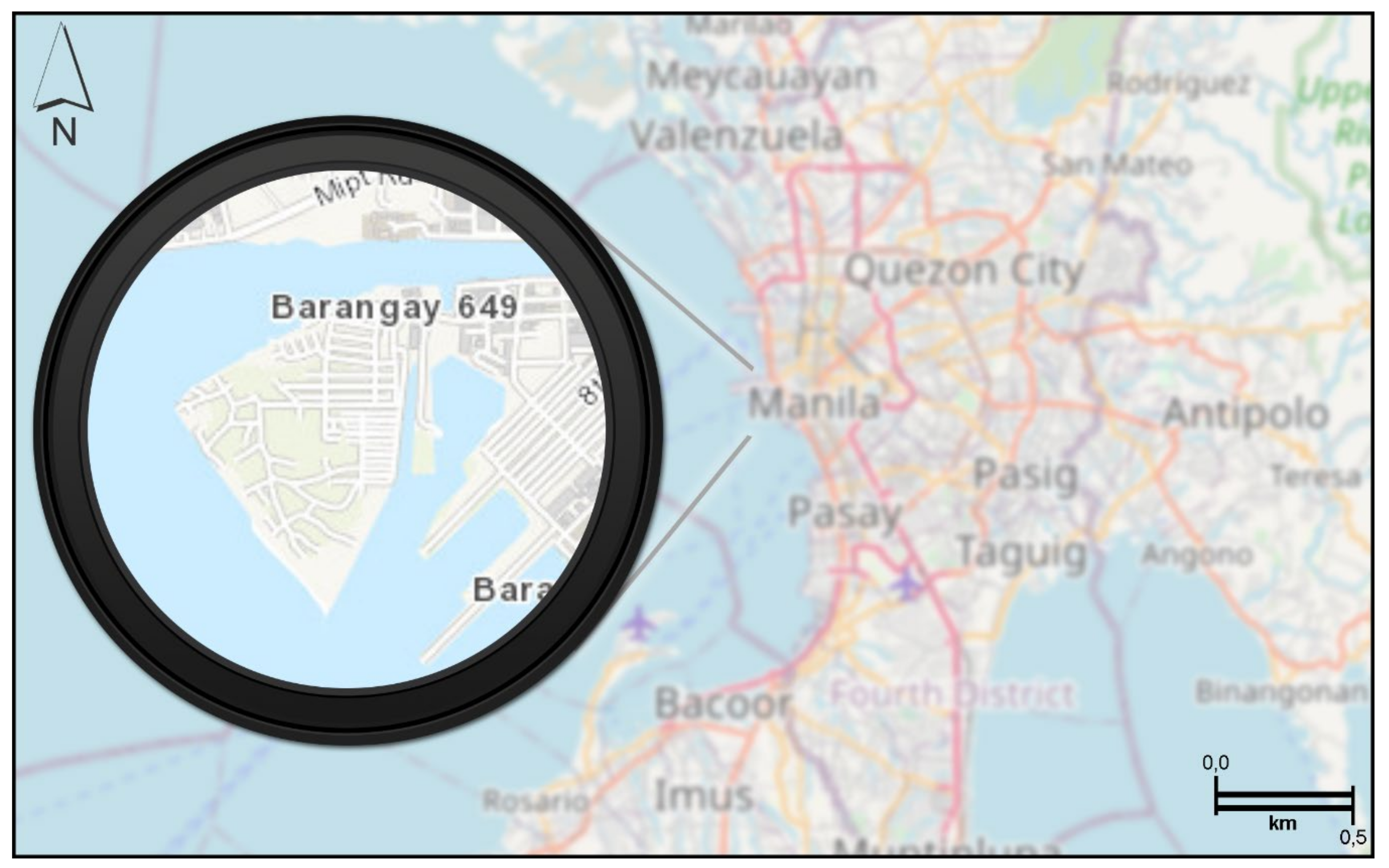
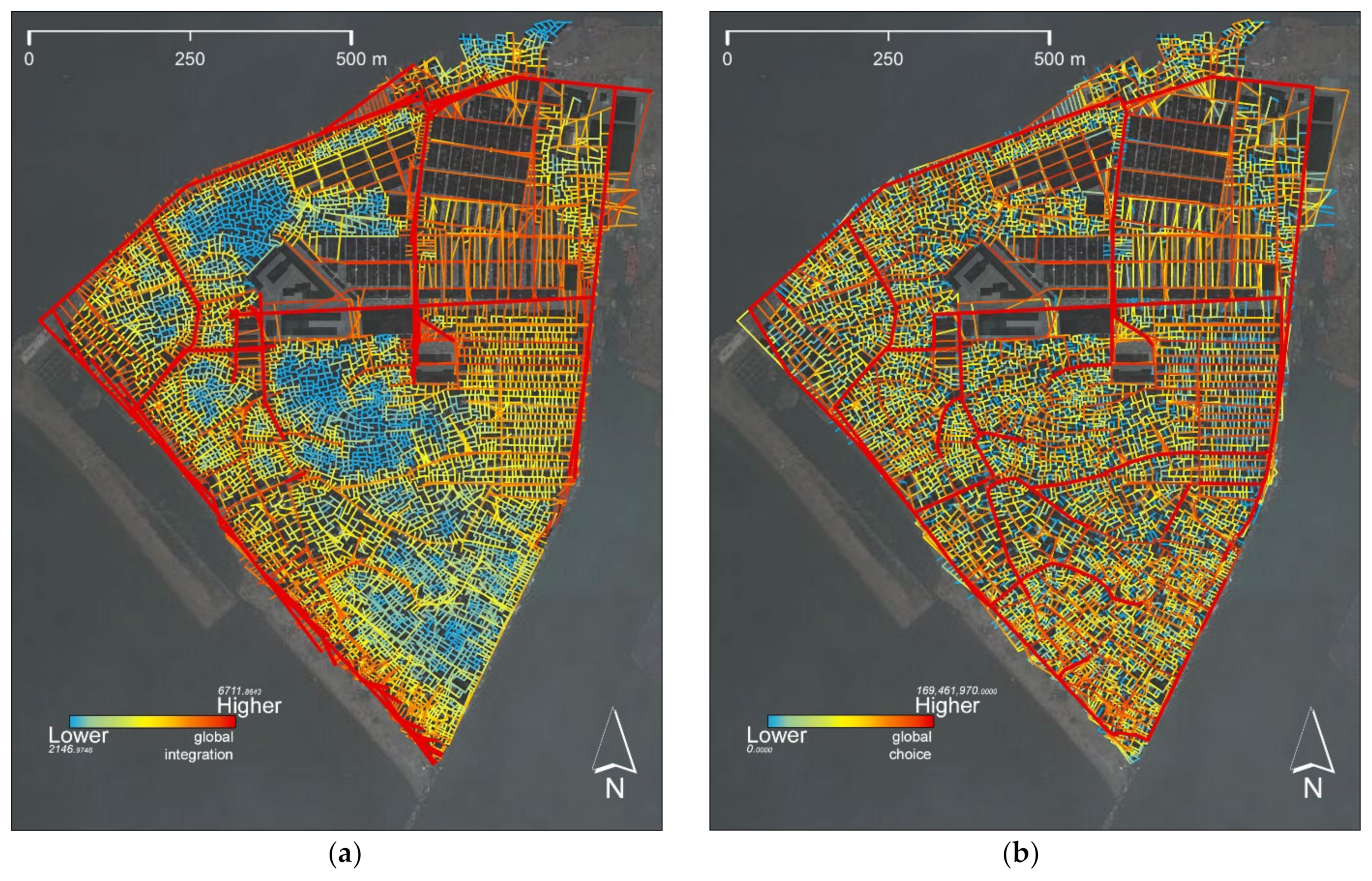
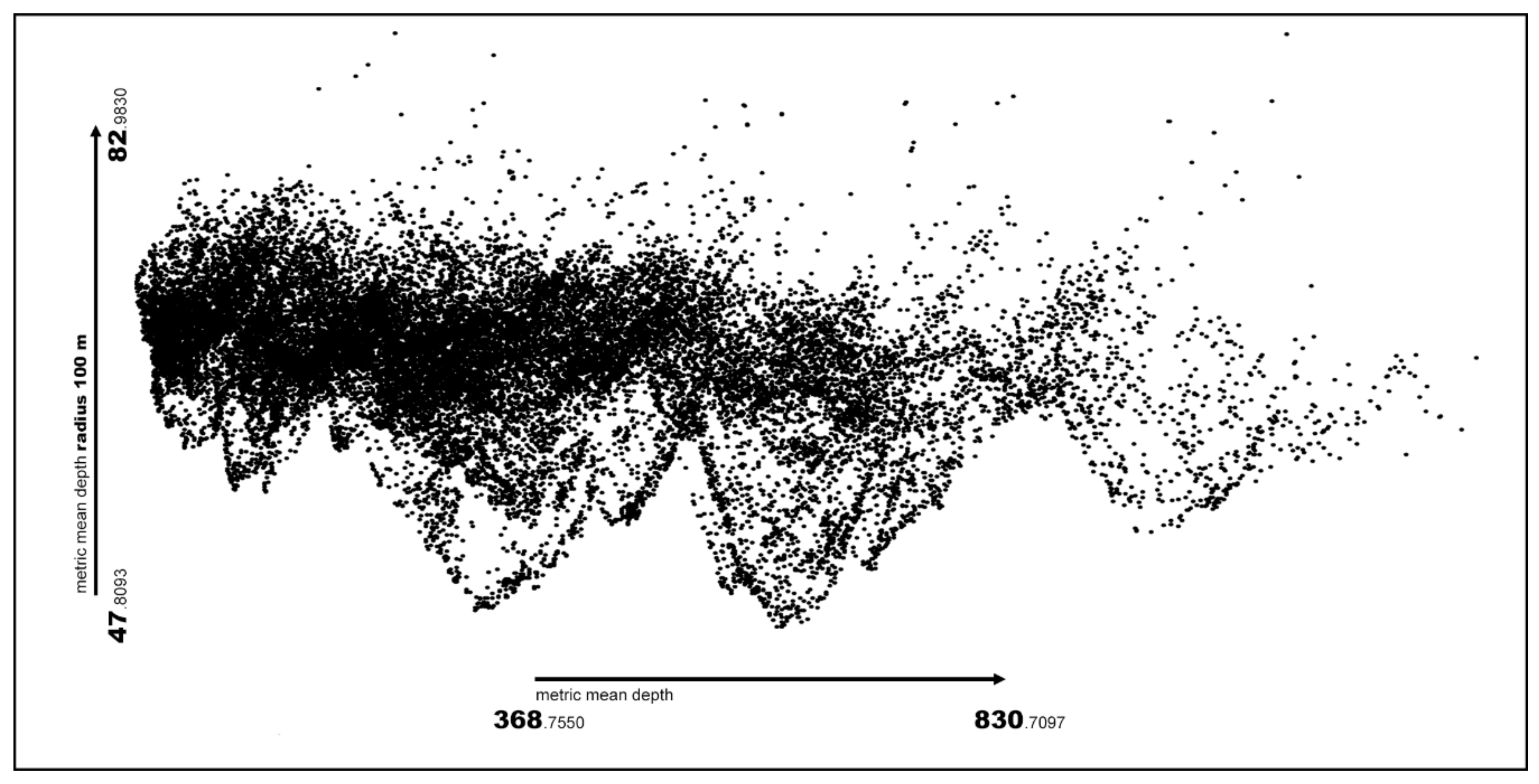
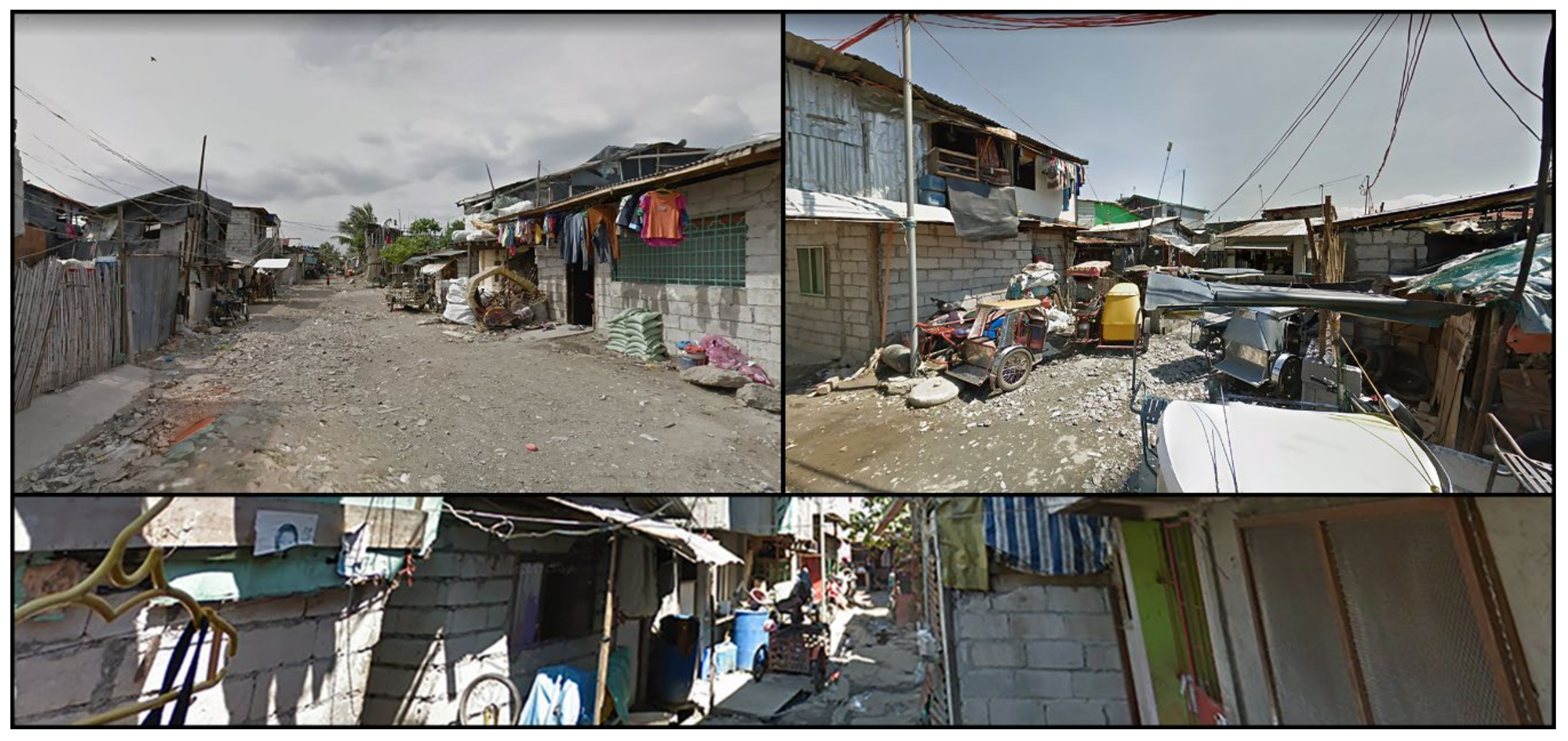
4. Case Study and Main Results

Located in the heart of the city of Manila, the capital of the Philippines, the informal settlement of BaSECo (Bataan Shipyard and Engineering Company) was built in the 1950s on reclaimed land as a barrier to mitigate flooding along the coastline (Figure 2).
The land consists of different recycled and waste materials resulted from the adjacent port of Manila, and in January 2002, when BaSECo was declared a residential site for the people already living there [90], the population has grown steadily, transforming this area into one of the most populated of the five Barangays in Manila’s port area.
The spontaneous growth of BaSECo left a deep trace of how it evolved, making it an ideal case study for the scope of this research. In this regard, a comprehensive analysis of its urban structure will allow for the targeting of specific parts of the districts where autopoietic principles are still manifested. The overall surface of BaSECo is approximately 60 hectares, almost doubled in size since the beginning of the century [19], and according to the Philippine Statistic Authority [91], the settled population is estimated between 60,000 and 90,000 units.
Connected to the mainland by a narrow strip of land, BaSECo is located at the mouth of the Pasig River, in proximity to “Intramuros,” the fortified city founded by the Spaniards in the 16th century. The city of Manila is experiencing unprecedented urbanization, which has generated a twin city where the formal and the informal are closely intertwined. The city has undergone alternate phases of crisis and economic growth; almost 40% of Manila’s population lives in informal settlements, and despite alternate phases of economic growth, the urbanization of its territory has continued uninterrupted [92].
In the near future, the Pasig River Rehabilitation Program will lead to dramatic shifts in the city’s fabric, including the relocation of large sectors occupied by informal communities. Under this program, BaSECo was selected as a priority area for substantial urban renewal. The general conditions of the settlement vary in different areas, but the need for housing, as well as the extremely high population density, have put incredible pressure on basic infrastructure and community services [93].
The main street network, which has enough space to allow for the circulation of people and vehicles, covers approximately 100,000 m, which corresponds to 19% of the district’s entire surface. The busiest area of BaSECo is located almost at the center of the street that formally crosses the district horizontally from east to west. The Benigno Aquino Elementary School and the President Corazon C. Aquino High School, which stand out for their urban fabric dimensions, are located close to the market and in the west part of this urban axis. Most of the main public facilities and institutional buildings, such as the church, the health center, the evacuation center, the barangay office, and two sports play-grounds, are located along this street or nearby.
Large areas in BaSECo present an organic configuration, and the mutating structure of the settlement does not allow access to a reliable and updated cartographic archive. A cartographic base was therefore developed through the interpretation of publicly accessible satellite images (Google Maps; Bing Maps), using the interpretative support provided by the cartographic services available for the area (Open street map), as well as the photographs present in the Google Street View archive and by the on-site observations conducted in the district since 2018 by the research team.
Based on a combination of semi-structured interviews and unstructured discussions with local residents and different stakeholders, the on-site analyses were also combined with the direct observation of spatial and social phenomena made through notes, sketching, and photo analysis. Additional datasets such as statistical information regarding population, movement patterns, quality, and typology of the urban fabric and open spaces were also collected to obtain a comprehensive picture of each area of the district [93].
Figure 3 and Figure 4 illustrate the configurational analysis results at the global and local levels. The global analysis, which refers to the entire urban network for calculating the centrality indexes, has been developed by using the integration and choice that have been proved to be the most robust configurational parameters. They provided an overview of the backbone of the settlement, both in terms of global attractive centralities (high index of integration) and the main links between the parts of the urban system (high choice index). The local analysis has been carried out by using metrical and topological steps radii.
In the urban system, the configurational analysis emphasizes the relationship between a whole and its parts; however, the meaning of a part as a “locality” is fuzzy, so that in this context different radii of the analysis have been used to understand how the city “functions” at different scales.
More specifically, the radius three integration (the integration calculated on the subnets defined by limiting the analysis to three topological steps from each line in the network) and radius 200 meters integration (the integration calculated on the subnets defined by limiting the analysis to 200 meters from each line in the network) has been implemented and presented. The first one is known to be a reliable predictor of pedestrian movement flows, which is preeminent in BaSECo, since it is related to how humans perceive space in outdoor navigation. The second one allows a clear view of the movement flows that derive from a three-minute walk, allowing local patterns of the settlement to emerge.
At the global level (Figure 3), the distribution of the values of the integration index (Figure 3a) highlights the lack of an area with a high closeness centrality, the so-called “integration core” [21]. This characteristic is commonly associated with an urban pathology, as it does not allow the full manifestation of the mechanisms dominating the urban phenomenology, which is essentially referred to as what is known as the “movement economy” [22]. As indicated by Hillier [94], the typical conformation of urban settlements consists of three different open spaces: the first one is manifested where the average closeness to all elements of the network is high and polarized (the integration core); the second one is composed of a series of spaces with medium-high integration that connects the edges of the settlement with its integration core, forming a “deformed wheel”; the third one is when there are lower integrated (segregated) areas.
In BaSECo the analysis revealed that highly integrated areas are located at the district’s edge along the streets (among the very few paved) that connect densely inhabited areas. Moreover, it can be observed that the most integrated areas correspond to the urban elements (in this case, streets that are suitable for small vehicles which have contributed to influence the pattern of the existing settlement.
A similar finding can be observed in the global choice index (Figure 3b), which follows the distribution of the global integration index (Figure 3a). This result supports the assumption that the urban structure of BaSECo can be explained as a set of localities organized by a series of paved streets, which consequently assume a primary position in the urban taxonomy. However, as argued later, this preliminary outcome can be misleading because the urban phenomenology takes place also in areas that are segregated at the global scale.
The local configurational analysis (Figure 4) highlights the presence of a high fragmentation on a small scale. Due to an accentuated gradient of local integration index’s values, this characteristic is not particularly visible from a topo-geometric analysis obtained with the implementation of a local metric radius of 200 meters (Figure 4a), but it is more evident in a purely topological local analysis. In fact, by using a local radius of three topological steps (Figure 4b), numerous isolated centralities clearly emerge, revealing what has been defined as a globular structure dominated by the spaces-in-between.
The analysis revealed a regularity that dominates the actual/existing autopoietic spaces of the district. It indicates two distinct structures, one at a global level, essentially of functional connection, and one at the local level, consisting of globular structures with high local integration. Specifically, the first one corresponds to areas with the highest values of the integration and choice indexes. In contrast, the second, which occupies the interstitial areas enclosed by the main paved roads, defines a foreground structure that makes the intra-urban connection easier.
The analysis of the metric density of the open spaces of BaSECo, performed with the BPA introduced in the previous section, is illustrated in Figure 5. It shows the diagram with a metric mean depth of 100 meters, highlighting lower peaks that correspond to the spaces-in-between (Figure 4b).
The outermost part points of the scatterplot are arranged in pseudo-parabolic sequences (Figure 6a), which express the presence of connected spaces that are located at a very low average distance from all the others in the local neighborhood (100 meters), corresponding to the spaces-in-between (Figure 6). Moreover, it can be observed that the points represented in the peaks at the far right of the main cloud (Figure 5) correspond to the elements located on the perimeter of the map, which are affected by the “edge effect” [95], that is the underestimation of its centrality indexes measures.
The configurational analysis of BaSECo was developed by using the methodology proposed in Section 3 and was focused to assess the consistency between the expected and effective functioning of the district.
The analysis of the urban morphology (Figure 7) revealed that almost 65% of the spatial pattern in BaSECo has an organic configuration and is located in the southwest part of the district, while the more regular patterns based on a sort of grid layout are located in the north-eastern part, near the port shoreline. The regular spatial patterns visible in Figure 7B are the results of urban regeneration programs implemented after a series of fires that affected the district since 2002 [96].
The building typologies vary in different areas of the district, presenting a multitude of spatial arrangements (Figure 8). For example, at the Dubai site, the organic spatial pattern is made up of mixed structures one or two stories high and is characterized by the use of multiple materials, generally recycled from the waste of various sources.
In other areas such as New Site and Gawad Kalinga, the regular spatial layout pro-vides relatively good living conditions with a high percentage of open spaces (mainly streets and back lanes). The built environment presents different characteristics; in the new site, the common typology is the two-floor house made of concrete that presents different customization modes in terms of decorations or construction elements. In Gawad Kalinga, the grid layout is constituted mainly by one-story high buildings upgraded by adding one or two stories [93].
In BaSECo, the lack of planning regulations and guidelines has generated dense urban areas where many residents live in precarious living conditions. Unpaved circulation spaces, flooding problems, and rubbish littering the streets are serious issues to be solved to provide a more sustainable urban environment.

5. Discussion and Conclusions

The quantitative analysis conducted on the informal BaSECo settlement provides an interesting perspective, potentially extendable to all autopoietic and self-organized settlements.
The research results outlined in this article support the hypothesis/assumption that informal settlements are urban systems governed by autopoietic mechanisms that are useful to understand how a human settlement could evolve under the pressure of social and economic forces. By analyzing the organic and spontaneous growth of their urban structure, it is possible to identify a regular structure, which can directly respond to the community’s needs. Therefore, the spaces-in-between are a paradigmatic case of how the relationship between urban spaces and community can reach an unpredictable balance.
As indicated, this manuscript highlights three main aspects: (a) informal settlements are significant cases to study autopoietic urban structures and self-organizing mechanisms; (b) the concept of regularity in urban planning cannot be limited to the geometry of urban spaces, but it must be extended to the coherence between the needs of the community and the configurational structure of the space; (c) space syntax spatial analysis techniques are a supporting tool for the analysis of autopoietic urban structures capable of providing in-depth knowledge.
It can be argued that the abovementioned aspects have different implications. On the one hand, they are strictly connected to the urban revitalization of informal settlements, which include a series of actions to make cities and human settlements safer and more inclusive, resilient, and sustainable, coherently with the point n.11 of the UN-Habitat sustainable development goals.
Although slums and low-income settlements are often associated with negative characteristics, they also have significant positive aspects that can be used to initiate a sustainable on-site upgrading strategy to solve the uncontrolled urban growth in emerging countries.
Furthermore, based on these considerations, a novel smart city paradigm could emerge from what we can learn from the informal city. One of the main challenges in modern urban planning was to organize the urban life of its citizens by proposing formal and functionalistic models based on a clear distinction of living, working, and leisure [97]. Top-down models have dominated the history of urban planning; however, according to Sabatier [98] (p. 22), “in the late 1970s and early I980s, a quite different approach emerged in response to the perceived weaknesses of the ‘top-down’ perspective”. In recent years, bottom-up approaches are flourishing to complement and integrate the lack of specificity of the more formal top-down approach by offering a more dynamic, flexible, and adaptive urbanism [99].
This study demonstrated how informal settlements, such as every urban environment, can be considered living and mutable organisms; specifically, they are particularly able to constantly evolve, absorbing the community’s needs and requirements. From this perspective, it can be assumed that the transition to a smart urban environment will become effective when cities acknowledge and support, in a flexible way, the changes that came from below. Similarly, it seems reasonable to argue that the smart city will be conceived not by simply adding high-tech functions and technological features to the existing infrastructures but through incremental and substantial social and spatial changes that involve all its components as well as the different stakeholders.
The development of a radical concept of a smart city depends on a deep understanding of the relationship between society and urban spaces, and the study presented in this article revealed how informal settlements could contribute to this knowledge. As a relevant example of autopoietic urban systems, the study of informal settlements could clarify how tangible and intangible urban phenomena shape the urban environment at different scales.
The study also highlights how configurational analysis and GIS technologies could support the transition to an inclusive smart city by predicting the impact of change in spatial structure in terms of numbers and measures and by giving policy-makers and practitioners an empirical framework to develop sustainable solutions in the short and long-term.
Finally, we hope to contribute to the on-going debate about the smart city by further developing the research methods explored in this paper. The study of the mechanism of auto-poietic settlements can facilitate the establishment of bottom-up planning strategies as well as contribute to the revitalization of underprivileged communities.
Future research on the informal district of BaSECo will be focused on the verification on-site of the findings obtained from the configuration analysis. This step will be relevant to develop a more appropriate and specific methods to integrate new knowledge by using ad hoc techniques [100,101,102] based on the formal representation of the urban environment through ontologies [67,103] and the “smart” use of big data [104,105].

Author Contributions

Conceptualization, Valerio Di Pinto, Antonio M. Rinaldi, and Francesco Rossini; Methodology, Valerio Di Pinto, Antonio M. Rinaldi, and Francesco Rossini; Investigation, Valerio Di Pinto, Antonio M. Rinaldi, and Francesco Rossini; Formal Analysis, Valerio Di Pinto; Writing—original draft Valerio Di Pinto and Antonio M. Rinaldi; Writing—review and editing, Valerio Di Pinto, Antonio M. Rinaldi, and Francesco Rossini. All authors have read and agreed to the published version of the manuscript.

Funding

This research received no external funding. The APC was funded by PON ARS01_00615 - OPL-APP.

Institutional Review Board Statement

Not applicable.

Informed Consent Statement

Not applicable.

Data Availability Statement

The data presented in this study are available on request from the corresponding author. The data are not publicly available due to privacy reasons.

Conflicts of Interest

The authors declare no conflict of interest.

References

  1. Albino, V.; Berardi, U.; Dangelico, R.M. Smart Cities: Definitions, Dimensions, Performance, and Initiatives. J. Urban Technol. 2015, 22, 3–21. [Google Scholar] [CrossRef]
  2. Dainow, B. Key Dialectics in Cloud Services. Sigcas Comput. Soc. 2015, 45, 52–59. [Google Scholar] [CrossRef]
  3. E-Governance for Smart Cities; Vinod Kumar, T.M. (Ed.) Springer: Singapore, 2015; p. 390. [Google Scholar]
  4. Komninos, N.; Schaffers, H.; Pallot, M. Developing a policy roadmap for smart cities and the future internet. In Proceedings of eChallenges e-2011 Conference, Florence, Italy, 26–28 October 2011; Cunningham, P., Cunningham, M., Eds.; IIMC International Information Management Corporation: Dublin, Ireland, 2011. [Google Scholar]
  5. Zygiaris, S. Smart City Reference Model: Assisting Planners to Conceptualize the Building of Smart City Innovation Ecosystems. J. Knowl. Econ. 2013, 4, 217–231. [Google Scholar] [CrossRef]
  6. Ahvenniemi, H.; Huovila, A.; Pinto-Seppä, I.; Airaksinen, M. What are the differences between sustainable and smart cities? Cities 2017, 60, 234–245. [Google Scholar] [CrossRef]
  7. Chaturvedi, K.; Kolbe, T.H. Towards establishing cross-platform interoperability for sensors in smart cities. Sensors 2019, 19, 562. [Google Scholar] [CrossRef] [Green Version]
  8. Han, B.; Tomer, V.; Nguyen, T.A.; Farmani, A.; Singh, P.K. (Eds.) Nanosensors for Smart Cities; Elsevier: Amsterdam, The Nederlands, 2020; p. 566. [Google Scholar]
  9. Costa, D.G.; Collotta, M.; Pau, G.; Duran-Faundez, C. A Fuzzy-Based Approach for Sensing, Coding and Transmission Configuration of Visual Sensors in Smart City Applications. Sensors 2017, 17, 93. [Google Scholar] [CrossRef]
  10. Pettersson, J.; Presser, M.; Vercher, J.B.; Muñoz, L.; Galache, J.A.; Gómez, L.A.H.; Hernández-Muñoz, J.M. Smart cities at the forefront of the future internet. In The Future Internet. FIA 2011; Lecture Notes in Computer Science; Domingue, J., Galis, A., Gavras, A., Zahariadis, T., Lambert, D., Cleary, F., Daras, P., Krco, S., Müller, H., Li, M., et al., Eds.; Springer: Berlin/Heidelberg, Germany, 2011; Volume 6656, pp. 447–462. [Google Scholar] [CrossRef] [Green Version]
  11. Balakrishna, C. Enabling Technologies for Smart City Services and Applications. In Proceedings of the 2012 Sixth International Conference on Next Generation Mobile Applications, Services and Technologies, Paris, France, 12–14 September 2012; IEEE: Piscataway, NJ, USA, 2012; pp. 223–227. [Google Scholar] [CrossRef] [Green Version]
  12. Atzori, L.; Iera, A.; Morabito, G.; Nitti, M. The social internet of things (siot)–When social networks meet the internet of things: Concept, architecture and network characterization. Comput. Netw. 2012, 56, 3594–3608. [Google Scholar] [CrossRef]
  13. Filipponi, L.; Vitaletti, A.; Landi, G.; Memeo, V.; Laura, G.; Pucci, P. Smart city: An event driven architecture for monitoring public spaces with heterogeneous sensors. In Proceedings of the 2010 Fourth International Conference on Sensor Technologies and Applications (SENSORCOMM), Venice-Mestre, Italy, 18–25 July 2010; IEEE: Piscataway, NJ, USA, 2010; pp. 281–286. [Google Scholar] [CrossRef]
  14. Buš, P.; Treyer, L.; Schmitt, G. Urban Autopoiesis: Towards Adaptive Future Cities. In Proceedings of the 22nd International Conference of the Association for Computer-Aided Architectural Design Research in Asia (CAADRIA) 2017, Suzhou, China, 5–8 April 2017; Janssen, P., Loh, P., Raonic, A., Schnabel, M.A., Eds.; The Association for Computer-Aided Architectural Design Research in Asia (CAADRIA): Hong Kong, China, 2017; pp. 695–705. [Google Scholar]
  15. Maturana, H.R.; Varela, F.J. Autopoiesis and Cognition: The Realization of the Living. In Boston Studies in the Philosophy of Science; Cohen, R.S., Wartofsky, M.W., Eds.; D. Riedel Publishing Company: Boston, MA, USA, 1980; Volume 42. [Google Scholar]
  16. Vaughan, L. The spatial syntax of urban segregation. Prog. Plan. 2007, 67, 205–294. [Google Scholar] [CrossRef] [Green Version]
  17. United Nations Task Team on Habitat III. Informal Settlements; UN-Habitat: New York, NY, USA, 2015; Habitat III Issue Papers; Volume 22. [Google Scholar]
  18. United Nations Task Team on Habitat III. The State of the World Cities Report 2012/13; Routledge: New York, NY, USA, 2013. [Google Scholar]
  19. Cutini, V.; Di Pinto, V.; Rinaldi, A.; Rossini, F. Informal Settlements Spatial Analysis Using Space Syntax and Geographic Information Systems. In Computational Science and Its Applications–ICCSA 2019; Lecture Notes in Computer Science; Misra, S., Gervasi, O., Murgante, M., Stankova, E., Korkhov, V., Torre, C., Rocha, A., Taniar, D., Apduhan, O., Tarantino, E., Eds.; Springer: Cham, Switzerland, 2019; Volume 11621. [Google Scholar] [CrossRef]
  20. Cutini, V.; Di Pinto, V.; Rinaldi, A.M.; Rossini, F. Proximal Cities: Does Walkability Drive Informal Settlements? Sustainability 2020, 12, 756. [Google Scholar] [CrossRef] [Green Version]
  21. Hillier, B.; Hanson, J. The Social Logic of Space; Cambridge University Press: Cambridge, UK, 1984. [Google Scholar]
  22. Hillier, B. Space is the Machine; Cambridge University Press: Cambridge, UK, 1996. [Google Scholar]
  23. Rossini, F.; Rinaldi, A.; Di Pinto, V. Public spaces and critical density, a preliminary study proposal for Baseco informal settlement in manila. In Proceedings of the XXIV ISUF International Conference: City and Territory in the Globalization Age, Valencia, Spain, 27–29 September 2017. [Google Scholar]
  24. Cutini, V.; Di Pinto, V. Informal settlements, complexity and urban models: Is there any order in autopoietic urban systems? In Environmental and Territorial Modelling for Planning and Design; Leone, A., Gargiulo, C., Eds.; FedOAPress: Naples, Italy, 2018. [Google Scholar]
  25. Neirotti, P.; De Marco, A.; Cagliano, A.C.; Mangano, G.; Scorrano, F. Current trends in Smart City initiatives: Some stylised facts. Cities 2014, 38, 25–36. [Google Scholar] [CrossRef] [Green Version]
  26. Marcus, L.; Koch, D. Cities as implements or facilities–The need for a spatial morphology in smart city systems. Environ. Plan B Urban Anal. City Sci. 2017, 44, 204–226. [Google Scholar] [CrossRef]
  27. Penn, A. Space Syntax and Spatial Cognition: Or Why the Axial Line? Environ. Behav. 2003, 35, 30–65. [Google Scholar] [CrossRef]
  28. Hillier, B. What do we need to add to a social network to get a society? Answer: Something like what you have to add to a spatial network to get a city. In Proceedings of the 7th International Space Syntax Symposium; Koch, D., Marcus, L., Steen, J., Eds.; KTH: Stockholm, Sweden, 2009. [Google Scholar]
  29. Netto, V. What is space syntax not?’ Reflections on space syntax as sociospatial theory. Urban Des. Int. 2016, 21, 25–40. [Google Scholar] [CrossRef]
  30. Hillier, B. Cities as movement economies. Urban Des. Int. 1996, 1, 41–60. [Google Scholar] [CrossRef]
  31. Angelidou, M. Smart city policies: A spatial approach. Cities 2014, 41, s3–s11. [Google Scholar] [CrossRef]
  32. Smart Cities Information System (SCIS). The Making of a Smart City: Policy Recommendations; Publication Office of the European Union: Luxembourg, 2017. [Google Scholar]
  33. Bolton, T.; Francis, N.; Froy, F. The impact of space syntax on urban policy making: Linking research into UK policy. In Proceedings of the 11th International Space Syntax Symposium; Heitor, T., Serra, M., Pinelo Silva, J., Bacharel, M., Cannas da Silva, L., Eds.; Instituto Superior Técnico-Departamento de Engenharia Civil, Arquitetura e Georrecursos: Lisbon, Portugal, 2017. [Google Scholar]
  34. Gupta, A.; Panagiotopoulos, P.; Bowen, F. An orchestration approach to smart city data ecosystems. Technol. Soc. Chang. 2020, 153. [Google Scholar] [CrossRef]
  35. Bhattacharya, S.; Somayaji, S.R.K.; Gadekallu, T.R.; Alazab, M.; Maddikunta, P.K.R. A review on deep learning for future smart cities. Internet Technol. Lett. 2020, e187. [Google Scholar] [CrossRef]
  36. Raghavan, S., Simon. Data Integration for Smart Cities: Opportunities and Challenges. In Computational Science and Technology; Alfred, R., Lim, Y., Haviluddin, H., On, C., Eds.; Springer: Singapore, 2020. [Google Scholar] [CrossRef]
  37. Szarek-Iwaniuk, P.; Senetra, A. Access to ICT in Poland and the Co-Creation of Urban Space in the Process of Modern Social Participation in a Smart City—A Case Study. Sustainability 2020, 12, 2136. [Google Scholar] [CrossRef] [Green Version]
  38. Lytras, M.D.; Visvizi, A.; Sarirete, A. Clustering Smart City Services: Perceptions, Expectations, Responses. Sustainability 2019, 11, 1669. [Google Scholar] [CrossRef] [Green Version]
  39. Granier, B.; Kudo, H. How Are Citizens Involved in Smart Cities? Analysing Citizen Participation in Japanese “Smart Communities”. Inf. Polity 2016, 21, 61–76. [Google Scholar] [CrossRef]
  40. Trencher, G. Towards the smart city 2.0: Empirical evidence of using smartness as a tool for tackling social challenges. Technol. Soc. Chang. 2019, 142, 117–128. [Google Scholar] [CrossRef]
  41. Rose, G. Actually-existing sociality in a smart city. City 2020, 1–18. [Google Scholar] [CrossRef]
  42. Margulis, L.; Sagan, D. Microcosmos: Four Billion Years of Microbial Evolution; University of California Press: Los Angeles, CA, USA, 1997. [Google Scholar]
  43. Ruiz-Mirazo, K.; Moreno, A. Basic autonomy as a fundamental step in the synthesis of life. Artif. Life 2004, 10, 235–259. [Google Scholar] [CrossRef] [PubMed]
  44. Luhmann, N. The autopoiesis of social systems. In Sociocybernetic Paradoxes: Observation, Control and Evolution of Self-steering Systems; Geyer, F., van der Zouwen, J., Eds.; Sage: London, UK, 1997; pp. 172–192. [Google Scholar]
  45. Rizzo, F. Il Capitale Sociale Della Città. Valutazione, Pianificazione e Gestione; Franco Angeli: Milano, Italy, 2002. [Google Scholar]
  46. Batty, M. The New Science of Cities; The MIT Press: Cambridge, MA, USA; London, UK, 2013. [Google Scholar]
  47. Klir, G.J. Complexity: Some general observations. Syst. Res. 1985, 2, 131–140. [Google Scholar] [CrossRef]
  48. Luhmann, N. Social Systems; Stanford University Press: Stanford, CA, USA, 1995. [Google Scholar]
  49. Prigogine, I.; Stengers, I. Order Out of Chaos: Man’s New Dialogue with Nature; Bantam Books: New York, NY, USA, 1984. [Google Scholar]
  50. Salingaros, N.A. Complexity and Urban Coherence. J. Urban Des. 2000, 5, 291–316. [Google Scholar] [CrossRef]
  51. Portugali, J. Planning. In Self-Organization and the City; Potugali, J., Ed.; Springer: Berlin, Heidelberg, Germany, 2000. [Google Scholar] [CrossRef]
  52. Aquilué, I.; Lekovic, M.; Sánchez, J.R. Urban Trauma and Self-organization of the City. Autopoiesis in the Battle of Mogadishu and the Siege of Sarajevo. Urban 2014, 2, 63–76. [Google Scholar]
  53. Davis, M. Planet of slums. New Perspect. Q. 2006, 30, 6–11. [Google Scholar] [CrossRef]
  54. Nuissl, H.; Heinrichs, D. Slums: Perspectives on the definition, the appraisal and the management of an urban phenomenon. Die Erde 2013, 144, 105–116. [Google Scholar] [CrossRef]
  55. Simiyu, S.; Cairncross, S.; Swilling, M. Understanding Living Conditions and Deprivation in Informal Settlements of Kisumu, Kenya. Urban Forum 2019, 30, 223–241. [Google Scholar] [CrossRef] [Green Version]
  56. Zerbo, A.; Delgado, R.C.; González, P.A. Vulnerability and everyday health risks of urban informal settlements in Sub-Saharan Africa. Glob. Health J. 2020. [Google Scholar] [CrossRef]
  57. Corburn, J.; Sverdlik, A. Informal Settlements and Human Health. In Integrating Human Health into Urban and Transport Planning; Nieuwenhuijsen, M., Khreis, H., Eds.; Springer: Cham, Switzerland, 2019; pp. 155–171. [Google Scholar] [CrossRef]
  58. United Nations Task Team on Habitat III. The Challenge of Slums. Global Report on Human Settlements; Earthscan Publications Ltd.: London, UK, 2003. [Google Scholar]
  59. Karimi, K.; Parham, E. An evidence informed approach to developing an adaptable regeneration programme for declining informal settlements. In Proceedings of the 8th International Space Syntax Symposium; Greene, M., Reyes, J., Castro, A., Eds.; Pontificia Universidad Católica de Chile: Santiago, Chile, 2012. [Google Scholar]
  60. Karimi, K.; Amir, A.; Shafiei, K.; Raford, N.; Abdul, E.; Zhang, J.; Mavridou, M. Evidence-based spatial intervention for regeneration of informal settlements: The case of Jeddah central unplanned areas. In Proceedings of the 6th International Space Syntax Symposium; Istanbul Technical University: Istanbul, Turkey, 2007. [Google Scholar]
  61. Batty, M. The Size, Scale, and Shape of Cities. Science 2008, 319, 769–771. [Google Scholar] [CrossRef] [Green Version]
  62. Di Pinto, V. C Come Paesaggio. Analisi Configurazionale e Paesaggio Urbano; Liguori Editore: Naples, Italy, 2018. [Google Scholar]
  63. Porta, S.; Crucitti, P.; Latora, V. The network analysis of urban streets: A dual approach. Phys. A 2006, 369, 853–866. [Google Scholar] [CrossRef] [Green Version]
  64. Pafka, E.; Dovey, K.; Aschwanden, G. Limits of space syntax for urban design: Axiality, scale and sinuosity. Environ. Plan B Urban Anal. City Sci. 2020, 47, 508–522. [Google Scholar] [CrossRef]
  65. Porta, S.; Crucitti, P.; Latora, V. The Network Analysis of Urban Streets: A Primal Approach. Env. Plann. B Plann. Des. 2006, 3, 705–725. [Google Scholar] [CrossRef] [Green Version]
  66. Cooper, C.; Chiaradia, A. sDNA: 3-d spatial network analysis for GIS, CAD, Command Line & Python. SoftwareX 2020, 12, 100525. [Google Scholar] [CrossRef]
  67. Cataldo, A.; Di Pinto, V.; Rinaldi, A.M. Representing and sharing spatial knowledge using configurational ontology. Int. J. Bus. Intell. Data Min. 2015, 10, 123–151. [Google Scholar] [CrossRef]
  68. Karimi, K. Space syntax: Consolidation and transformation of an urban research field. J. Urban Des. 2018, 23, 1–4. [Google Scholar] [CrossRef] [Green Version]
  69. Wasserman, S.; Faust, K. Social Network Analysis: Methods and Applications. Structural Analysis in the Social Sciences; Cambridge University Press: Cambridge, UK, 1994. [Google Scholar] [CrossRef]
  70. Porta, S.; Crucitti, P.; Latora, V. Multiple centrality assessment in Parma: A network analysis of paths and open spaces. Urban Des. Int. 2008, 13, 41–50. [Google Scholar] [CrossRef] [Green Version]
  71. Freeman, L. Centrality in Social Networks Conceptual Clarification. Soc. Netw. 1978, 1, 215–239. [Google Scholar] [CrossRef] [Green Version]
  72. Xiao, Y. Space Syntax Methodology Review. In Urban Morphology and Housing Market; Xiao, Y., Ed.; Springer: Singapore, 2018. [Google Scholar] [CrossRef]
  73. Di Pinto, V.; Rinaldi, A.M. A configurational approach based on geographic information systems to support decision-making process in real estate domain. Soft Comput. 2019, 23, 2853–2862. [Google Scholar] [CrossRef]
  74. Tarabieh, K.; Nassar, K.; Abdelrahman, M.; Mashaly, I. Statics of space syntax: Analysis of daylighting. Front. Arch. Res. 2019, 8, 311–318. [Google Scholar] [CrossRef]
  75. Nourian, P.; Rezvani, S.; Sariyildiz, I.S. Designing with Space Syntax: A configurative approach to architectural layout, proposing a computational methodology. In Proceedings of the 31st International Conference on Education and Research in Computer Aided Architectural Design in Europe; Delft University of Technology: Delft, The Netherlands, 2013. [Google Scholar]
  76. Van Nes, A. The one- and two-dimensional isovists analyses in Space Syntax. Res. Urban. Ser. 2011, 2, 163–183. [Google Scholar] [CrossRef]
  77. Al_Sayed, K.; Turner, A.; Hillier, B.; Iida, S.; Penn, A. Space Syntax Methodology; Bartlett School of Architecture, UCL: London, UK, 2014. [Google Scholar]
  78. Rinaldi, A.M. A GIS-based system for electromagnetic risk management in urban areas. J. Locat. Based Serv. 2009, 3, 3–23. [Google Scholar] [CrossRef]
  79. ArcGIS Desktop. A Complete Suite for Desktop GIS. Available online: https://www.esri.com/en-us/arcgis/products/arcgis-desktop/overview (accessed on 3 August 2020).
  80. Space-Group UCL-depthmapX Development Team (DepthmapX-Version 0.6.0). Available online: https://github.com/SpaceGroupUCL/depthmapX/ (accessed on 3 August 2020).
  81. Turner, A.; Hillier, B. An Algorithmic Definition of the Axial Map. Environ. Plann. B Plann. Des. 2005, 33, 425–444. [Google Scholar] [CrossRef]
  82. Ratti, C. Space Syntax: Some Inconsistencies. Environ. Plann. B Plann. Des. 2004, 31, 487–499. [Google Scholar] [CrossRef]
  83. Ratti, C. Rejoinder to Hillier and Penn. Environ. Plann. B Plann. Des. 2004, 31, 513–516. [Google Scholar] [CrossRef]
  84. Turner, A. Angular Analysis. In Proceedings of the 3rd International Space Syntax Symposium; Georgia Tech School of Architecture: Atlanta, GA, USA, 2001. [Google Scholar]
  85. Hillier, B. Spatial sustainability in cities: Organic patterns and sustainable forms. In Proceedings of the 7th International Space Syntax Symposium; Koch, D., Marcus, L., Steen, J., Eds.; KTH: Stockholm, Sweden, 2009. [Google Scholar]
  86. Al_Sayed, K. The signature of self-organisation in cities: Temporal patterns of clustering and growth in street networks. Int. J. Geomat. Spat. Anal. 2013, 23, 379–406. [Google Scholar]
  87. Batty, M. The ajax project: New theory and new software for space syntax. In Proceedings of the 5th International Space Syntax Symposium; Van Nes, A., Ed.; Delft University of Technology: Delft, The Netherlands, 2005. [Google Scholar]
  88. Gil, J.; Stutz, C.; Chiaradia, A. Confeego: Tool Set for Spatial Configuration Studies. In Proceedings of the 6th International Space Syntax Symposium; Istanbul Technical University: Istanbul, Turkey, 2007. [Google Scholar]
  89. Dalton, N.S. Webmap; Ovinity Ltd.: London, UK, 2002. [Google Scholar]
  90. Government of The Philippines (GOVPH) Proclamation No. 145, s. 2002|Official Gazzette of The Republic of The Philippines, 2002. Available online: http://www.officialgazette.gov.ph/2002/01/18/proclamation-no-145-s-2002/ (accessed on 23 March 2021).
  91. Philippine Statistic Authority: Highlights of the Philippine Population 2015 Census of Population. Available online: https://psa.gov.ph/content/highlights-philippine-population-2015-census-population (accessed on 6 August 2020).
  92. Ortega, A.A.C. Manila’s metropolitan landscape of gentrification: Global urban development, accumulation by dispossession and neoliberal warfare against informality. Geoforum 2016, 70, 35–50. [Google Scholar] [CrossRef]
  93. Rossini, F. Regenerating Informal Settlements Through Mapping and Public Space: The Case of BaSECo Compound in Manila. In Resilient Urban Regeneration in Informal Settlements in the Tropics. Advances in 21st Century Human Settlements; Carracedo, O., Ed.; Springer: Singapore, 2020. [Google Scholar] [CrossRef]
  94. Hillier, B. The Architecture of the Urban Object. Ekistics 1989, 56, 5–21. [Google Scholar]
  95. Vaughan, L.; Geddes, I. Urban form and deprivation: A contemporary proxy for Charles Booth’s analysis of poverty. Radic. Stat. 2009, 99, 46–73. [Google Scholar]
  96. Galuszka, J. Community-based approaches to settlement upgrading as manifested through the big ACCA projects in Metro Manila, Philippines. Environ. Urban. 2014, 26, 276–296. [Google Scholar] [CrossRef] [Green Version]
  97. Benevolo, L. History of Modern Architecture; MIT Press: Cambridge, MA, USA, 1977. [Google Scholar]
  98. Sabatier, P. Top-Down and Bottom-Up Approaches to Implementation Research: A Critical Analysis and Suggested Synthesis. J. Public Policy 1989, 6, 21–48. [Google Scholar] [CrossRef]
  99. Bishop, P.; Williams, L. The Temporary City; Routledge: Oxon, UK, 2012. [Google Scholar]
  100. Caldarola, E.G.; Rinaldi, A.M. A multi-strategy approach for ontology reuse through matching and integration techniques. Adv. Intell. Syst. Comput. 2018, 561, 63–90. [Google Scholar]
  101. Rinaldi, A.M.; Russo, C. A Matching Framework for Multimedia Data Integration Using Semantics and Ontologies. In Proceedings of the 12th IEEE International Conference on Semantic Computing, ICSC 2018, Laguna Hills, CA, USA, 31 January–2 February 2018. [Google Scholar] [CrossRef]
  102. Rinaldi, A.M.; Russo, C.; Madani, K. A semantic matching strategy for very large knowledge bases integration. Int. J. Inf. Technol. Web Eng. 2020, 15, 1–29. [Google Scholar] [CrossRef]
  103. Cataldo, A.; Cutini, V.; Di Pinto, V.; Rinaldi, A.M. Subjectivity and Objectivity in Urban Knowledge Representation. In Proceedings of the International Conference on Knowledge Discovery and Information Retrieval–KDIR 2014; Fred, A., Dietz, J.L.G., Aveiro, D., Liu, K., Filipe, J., Eds.; Scitepress: Setubal, Portugal, 2014. [Google Scholar] [CrossRef] [Green Version]
  104. Di Pinto, V.; Rinaldi, A.M. Big Data. Towards an approach to integrate Subjectivity and Objectivity in representing and managing data to support decision making in urban planning domain. In Decision Making in Urban and Territorial Planning; Di Pinto, V., Ed.; Maggioli Editore: Sant’Arcangelo di Romagna, Italy, 2020. [Google Scholar]
  105. Caldarola, E.G.; Rinaldi, A.M. Big data: A survey: The new paradigms, methodologies and tools. In Proceedings of the DATA 2015-4th International Conference on Data Management Technologies and Applications; Helfert, M., Holzinger, A., Belo, O., Francalanci, C., Eds.; Springer: Cham, Switzerland, 2015. [Google Scholar]
Figure 1. System architecture.
Ijgi 10 00202 g001
Figure 2. BaSECo informal settlement (Barangay 649), in the frame of the metropolitan city of Manila. Basemap source: Open Street Map.
Ijgi 10 00202 g002
Figure 3. Configurational analysis of the BaSECo informal settlement: (a) global integration index; (b) global choice. Values vary from blue (lower) to red (higher). Widest red lines highlight the 20-quantile of higher values. Closed spaces are filled with black, solid hatch.
Ijgi 10 00202 g003
Figure 4. Configurational analysis of BaSECo informal settlement: (a) local integration index, metric radius 200; (b) local integration index, topological radius three steps. Graphics as Figure 3.
Ijgi 10 00202 g004
Figure 5. Background patchwork analysis of BaSECo with metric mean depth radius 100 (Y-axis).
Ijgi 10 00202 g005
Figure 6. Background patchwork analysis (BPA) of BaSECo: (a) zoomed view of BPA at 100 m (Figure 5): red dots highlight the metric density of the space-in-between’s globular structure reported in sub-figures (b) zoomed view of local integration index with topological radius three steps (Figure 4b), and (c) location of the analyzed area on the urban network.
Ijgi 10 00202 g006
Figure 7. Qualitative analysis of BaSECo: (a) urban districts; (b) building types. The pie chart on the right side highlights the dominance of squatters over the other building types.
Ijgi 10 00202 g007
Figure 8. Squatters in different districts of BaSECo (Google Street View 2020).
Ijgi 10 00202 g008
Publisher’s Note: MDPI stays neutral with regard to jurisdictional claims in published maps and institutional affiliations.

