Article

What Happens in the City When Long-Term Urban Expansion and (Un)Sustainable Fringe Development Occur: The Case Study of Rome

1
Planning and Design Faculty, Agricultural University of Iceland, Hvanneyri, 311 Borgarbyggð, Iceland
2
Department of Economics and Law, University of Macerata, Via Armaroli 43, 62100 Macerata, Italy
3
IMAA—CNR (Institute of Methodologies for Environmental Analysis—Italian National Research Council), c.da Santa Loja snc, 85050 Tito Scalo (PZ), Italy
4
Department of Overland Communication Ways, Foundation and Cadastral Survey, Politehnica University of Timisoara, 1A I. Curea Street, 300224 Timisoara, Romania
5
Mathematics, Computer Science and Economics Department, University of Basilicata, Viale dell’Ateneo Lucano, 85100 Potenza, Italy
6
Global Change Research Institute CAS, Lipova 9, 370 05 Ceske Budejovice, Czech Republic
7
Department of Agricultural and Forestry Sciences (DAFNE), Tuscia University, Via San Camillo de Lellis, 01100 Viterbo, Italy
*
Author to whom correspondence should be addressed.
ISPRS Int. J. Geo-Inf. 2021, 10(4), 231; https://0-doi-org.brum.beds.ac.uk/10.3390/ijgi10040231
Submission received: 16 February 2021 / Revised: 29 March 2021 / Accepted: 4 April 2021 / Published: 6 April 2021
(This article belongs to the Special Issue Geodata Science and Spatial Analysis in Urban Studies)

Abstract

:
This study investigates long-term landscape transformations (1949–2016) in urban Rome, Central Italy, through a spatial distribution of seven metrics (core, islet, perforation, edge, loop, bridge, branch) derived from a Morphological Spatial Pattern Analysis (MSPA) analyzed separately for seven land-use classes (built-up areas, arable land, crop mosaic, vineyards, olive groves, forests, pastures). A Principal Component Analysis (PCA) has been finally adopted to characterize landscape structure at 1949 and 2016. Results of the MSPA demonstrate how both natural and agricultural land-uses have decreased following urban expansion. Moreover, the percent ‘core’ area of each class declined substantially, although with different intensity. These results clearly indicate ‘winners’ and ‘losers’ after long-term landscape transformations: urban settlements and forests belong to the former category, the remaining land-use classes (mostly agricultural) belong to the latter category. Descriptive statistics and multivariate exploratory techniques finally documented the intrinsic complexity characteristic of actual landscapes. The findings of this study also demonstrate how settlements have expanded chaotically over the study area, reflecting a progressive ‘fractalization’ and inhomogeneity of fringe landscapes, with negative implications for metropolitan sustainability at large. These transformations were unable to leverage processes of settlement and economic re-agglomeration around sub-centers typical of polycentric development in the most advanced socioeconomic contexts.

1. Introduction

Moving further away from inner cities, vastly different landscapes have been more intensively shaped by settlement expansion. Urban growth and the intimate interrelations with land-use represents a complex issue involving multiple planning and ecological dimensions [1,2,3]. Landscape transformations in metropolitan regions are often the result of interactions between (apparent and latent) socioeconomic factors of change [4,5,6]. The linkage between land-use changes and demographic dynamics in economically advanced countries is becoming increasingly multifaceted because of the mutual interplay of environmental and planning spheres that influence the sustainable development of regions and local communities [7,8,9]. In this sense, exurban development has been strongly influenced by land prices’ variations, altering the equilibrium of forces, which has profoundly shaped the actual organization of economic activities within cities [1,10,11,12]. The monocentric model, intended as a characteristic and simplified urban spatial structure, has for a long time represented the basis for economic analysis and evaluation [13,14,15,16]. According to the monocentric model, central cities hold a core area concentrating upper socioeconomic functions (e.g., population density, land value, house prices, dwelling characteristics, and capital-land ratio) reflected in a specific land-use profile [5,17,18]. As we move outward, these functions gradually decrease in intensity and/or spatial extent [19]. However, given the progressive and irregular expansion of cities with different sizes (from large to small extent), the monocentric model does not provide an accurate and realistic depiction of the land use structure [20,21,22,23]. Recently, the polycentric model has been considered more appropriate in capturing the current spatial structure of urban areas [24,25,26,27]. The third, even more frequent way of urban growth is now the exurban development (i.e., the characteristic pattern of urban expansion following low-density settlements scattered on a natural or agricultural matrix [1,28,29] resulting in urban morphologies very different from the traditional monocentric and polycentric structures [30,31,32]).
Exurban expansion usually tends to produce fragmented landscapes without distinctive features of the polycentric model (such as production poles or sub-centers [33]). Land-use changes in peri-urban areas have been the subject of a series of studies indicating also possible knock-on effects on environmental matrices [34,35,36,37,38,39,40,41]; on the contrary, the relationship between landscape changes and the three different ways of urban enlargement (monocentric, polycentric and dispersed, see Figure 1) has not yet been adequately studied, especially in areas where anthropogenic pressure has increased more rapidly in recent years [42,43,44]. Fortunately, land use databases are increasing in size and populate the web more frequently with respect to a recent past, involving all the geographic scales [45,46,47]. Therefore, the most suitable tools to validate working assumptions on the different urban development modalities and to verify the reliability of various indicators rely on land-use datasets [48]. In this context, exploratory analysis is a possible approach to shed light on the complex links between structures, functions and change dynamics of (rapidly expanding) urban settlements [49].
Our work introduces an original perspective summarizing today’s knowledge and scientific directions in the field of long-term urban expansion in light of different models of urban growth. To our knowledge, we present here the first study documenting (and quantitatively analyzing) long-term (nearly 70 years) landscape transformations in a Mediterranean peri-urban landscape, bringing substantial implications for diachronic analysis of urban expansion in developed (but peripheral) countries in Europe. As a novel contribution to landscape studies, the present work focuses on the prevalent modes of urban expansion occurred in Rome over a relatively long-time span (1949–2016) by performing a comprehensive, spatially explicit analysis of landscape transformations based on a mathematical spatial morphology approach. In the last half century, the metropolitan area of Rome, a typical semi-compact and dense Mediterranean city, has undergone different, sometimes conflicting, waves of settlement expansion, representing a paradigmatic example of urban transformations in the whole southern Europe [42,50,51,52]. The empirical results of this study allow discussing the (supposed) unsustainability of current urban expansion compared with the past settlement structures as far as land fragmentation and loss of relict habitats and traditional crops at the fringe are concerned. At the same time, our study presents polycentric urban growth as a candidate for a feasible and more sustainable means of metropolitan development and, possibly, urban containment, in compact Mediterranean cities.

2. Materials and Methods.
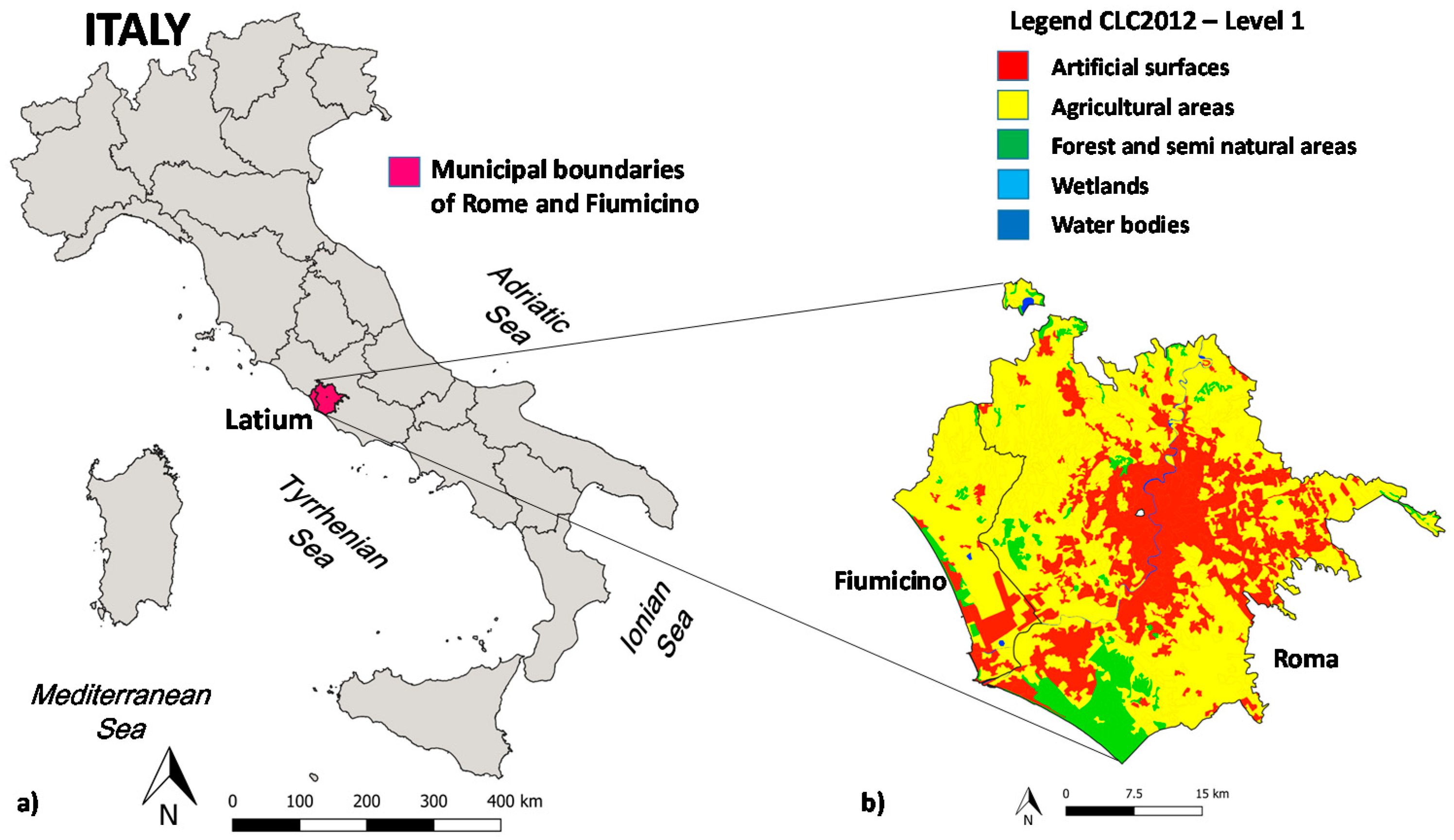
2.1. Study Area

The investigated area covers a part of Rome’s province including the local municipalities of Rome and Fiumicino, for a total surface area of 1500 km2 (Figure 2). The lowlands (the so called ‘Agro Romano’, a cultivated area with traditional rural landmarks, biodiversity and cultural heritage) surrounded the inner city of Rome expanded through the alluvial plain of the Tiber river [53]. Although the increasing human pressure threatened the original forest vegetation, relict forests are preserved along the coastal rim. Industrial areas are located in the eastern part of the city while traditional cropland intermixed with pasture and shrub land still occur in the western part of the study area. Rome’s climate is typically Mediterranean with rainfalls concentrated in autumn and spring and relatively mild temperatures in winter. The average long-term (1961–1990) annual rainfall and mean daily temperature in Rome were 700 mm and 16 °C respectively. However, decreased precipitation rate and increasing average temperatures have been recorded in recent decades.

2.2. Land-Use Maps

Land-use data were obtained from the elaboration of two compatible spatial geo-databases with a digital land classification based on a simplified Corine Land Cover classification nomenclature [50,51,52,53,54]: (i) the Italian Istituto Geografico Militare topographic map (1:25,000 scale) produced in 1949, and (ii) a land-use map (1:25,000) produced by the Cartographical Service of the Latium regional authority derived from photo-interpretation of digital ortho-images released from the Italian National Geoportal (this map was originally produced in 1999–2000 and completely updated in 2016 with new images referring to the same year). They were processed and reprojected to the common WGS84 UTM zone 32 in GIS environment (QGIS 3.14.1, see http://qgis.osgeo.org (accessed on 5 April 2021)). Seven homogeneous classes with a minimum mapping unit of 1 hectare were selected as follows: (i) arable land, (ii) mixed cropland, (iii) vineyards, (iv) olive groves, (v) forests, (vi) pastures, (vii) built-up areas, and (viii) wetlands and other (minor) use of land (e.g., beaches, dunes, rocks). The related figures were qualitatively checked for consistency with independent official data derived from statistical sources, e.g., agricultural and building censuses, rural surveys, land price maps, cadastral maps. These comparisons were preliminary to further analysis and were carried out with the purpose only of verifying that different data sources were coherent in addressing the same landscape transformations (i.e., expansion of urban settlements, decline of arable land, moderate increase of forestland) over such a time interval (1949–2016).

2.3. Landscape Analysis
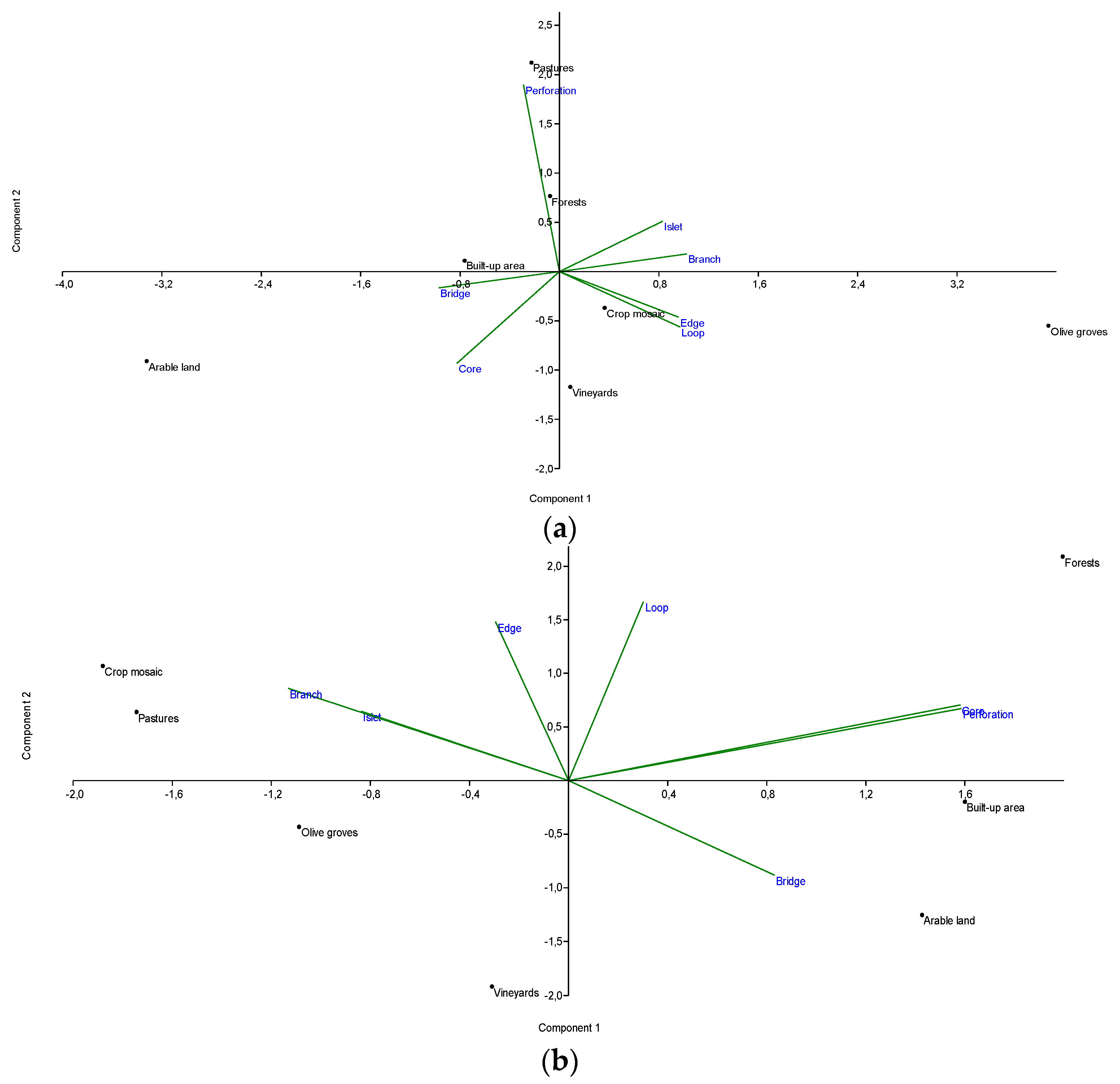
Landscape composition (1949 and 2016) and annual per cent rate of change were been calculated by land-use class. Additionally, we used Guidos software [55] to classify landscapes based on Mathematical Spatial Pattern Analysis (MSPA), a technique investigating shape and form of objects [56,57,58]. MSPA is a customized sequence of mathematical morphological operators aimed at describing geometry and connectivity of the image components. As it is based on geometric principles, MSPA can cover different kinds of applications independently of scale and type of digital images in any application field (for further details, see https://forest.jrc.ec.europa.eu/en/activities/lpa/mspa/ (accessed on 5 April 2021)). This methodology implements image processing routines to identify hubs, corridors and other spatial elements relevant to landscape analysis [57]. Seven basic elements were identified here: (i) ‘core’, (ii) ‘islet’, (iii) ‘bridge’, (iv) ‘loop’, (v) ‘branch’, (vi) ‘edge’, and (vii) ‘perforation’ (Figure 3). ‘Core’ areas are the inner part beyond a certain distance to the boundary, ‘islets’ are those portions of land that are too small and isolated to contain a core area. Each core area is surrounded by ‘edges’ and ‘perforations’. Perforated areas were defined as transition zones between ‘cores’ and a different land-use class, while ‘edges’ represent the transition between ‘core’ and ‘non-core’ areas within the same class. Loops, bridges and branches connect “core” areas. Loop areas represent corridors which connect to the same core, bridges connect two (or more) cores and branches connect a core area with a non-core area within the same land-use class. A Principal Component Analysis was run on a matrix composed of the relative proportion of the seven morphological classes (see above) by land-use category and year. The data matrix was constituted of seven columns (morphological classes) and seven land-use classes (rows) and contains the respective value (see above) by column and row as a proxy of landscape structure and composition together. To delineate similarities in the spatial configuration of the studied landscape, a biplot illustrating the statistical distribution of component loadings (morphological categories) and scores (land-use classes) was used. This plot contributed to representing the latent relationships in the composition and structure of the investigated landscape, providing a new perspective (and operational tools) in land-use analysis. Components were extracted on the base of the absolute eigenvalue; components with eigenvalue > 1 were considered significant and analyzed further.

3. Results

Table 1 reports aggregated and individual class changes in landscape composition over the study period. While built-up areas expanded significantly from 6.6% in 1949 to 28.9% in 2016, the largest decline was observed for agricultural systems including pastures (from 81.5% to 58.3%). Forests increased moderately and other land use classes (including wetlands and water bodies) remained largely stable. Among agricultural systems, arable land experienced the largest negative change (Figure 4). Less intense changes were observed for vineyards (decreasing), olive groves, pastures and crop mosaics (slightly increasing).
Based on MSPA, trends over time in the per cent ‘core’ area were illustrated in Table 2. Built-up areas contained a relatively stable proportion of ‘core’ patches with a moderate increase from 34.9% in 1949 to 35.7% in 2016. Arable land, vineyards, pastures and crop mosaics experienced the most intense decline over time. The other classes had a less intense decline in ‘core’ parches; forests were the class with the lowest negative rate of change in ‘core’ patches.
Specifically focusing on built-up areas, changes over time in the average patch size (ha) is shown in Table 3 by morphological class. While patches classified as ‘cores’ remain the largest for both years, their size declined significantly during the study period. The same pattern was observed for ‘edge’ patches. By contrast, ‘bridges’ increased significantly over time, likely suggesting a sort of landscape ‘fractalization’ in smaller patches with some intrinsic interconnections.
Figure 5 illustrates the empirical results of a Principal Component Analysis run on the bi-dimensional matrix linking land-use classes and morphological categories with the use of a representative target variable, the average patch size. For 1949, PCA extracted two main components explaining together 83.5% of landscape variability. Component 1 (65.1%) discriminated largely un-fragmented landscapes dominated by arable land (right side) from patchy agricultural systems mostly associated with olive groves (smaller patch size). Core, bridge, edge, loop were the classes most associated with Component 1. Component 2 (18.4%) discriminated pastures and forests from vineyards evidencing the intrinsic role of ‘perforation’ class. All in all, 1949 landscape structure was rather simplified and oriented towards intensity of land-use. The contribution of built-up areas in landscape variability was quite modest. The biplot (loadings vs. scores) clearly discriminated natural systems, extensive rural systems and intensive crops were discriminated.
For 2016, PCA extracted two main components accounting together for 66.2% of landscape variability. Component 1 (39.1%) discriminated un-fragmented landscapes dominated by built-up areas and arable land together (right side) from fragmented agricultural-natural systems associated with olive groves, pastures and crop mosaics (smaller patch size). This result suggests an increasing fractalization of peri-urban landscapes, mixing residential settlements and arable land (typical association observed at the fringe of Rome). Extensive rural systems further away from the fringe are becoming increasingly fragmented with a latent association between natural covers and productive crops (pastures, olive tree, crop mosaic). Perforation and core patches were mostly associated with built-up areas and arable land. Islet and branch categories are primarily associated with olive groves, pastures and crop mosaic. Component 2 (27.1%) discriminated forests from vineyards evidencing the role of ‘edge’ and ‘loop’ categories. Based on these results, the actual landscape structure was intrinsically more complex and less ordered along a land-use intensity gradient, evidencing in turn the important contribution of built-up areas to landscape variability.

4. Discussion

In recent years, comparative analysis aimed at capturing underlying patterns and trends from land-use databases has been fed by a continuous demand for high-resolution data as well as reliable indicators and new methodologies [60,61,62,63,64,65,66,67]. This work focuses on land-use changes occurring in Rome, which has grown very fast over the last seventy years, to infer different means of urban expansion using exploratory data analysis. The role of a continuous monitoring of land use is a fundamental support for sustainable development policies in urban regions [68]. In areas, such as those of southern Europe, characterized by generally small-fragmented cities [69,70,71,72], polycentric patterns have infrequently been observed with the exception of a few limited cases. In comparison with northern and western European regions [14,16,73,74,75], typified by polycentric modes of urban development, Mediterranean cities have experienced a partial failure of this model due to their specific socio-economic features [18,76,77]. Recently, in fact, significant changes in morphology and socio-economic structures have been found in many Mediterranean cities as a result of incoming sprawling phenomena [78,79,80] following a more dispersed (and not polycentric) pattern [42,81,82]. In the specific case of the city of Rome, thanks to morphological analysis, how the landscape changed its structure following different waves of expansion of various intensities occurring in recent decades was demonstrated.
In particular, local socioeconomic contexts in the study area have sometimes accelerated the emergence of a more scattered and discontinuous agglomeration to the detriment of a denser and more compact asset, with severe consequences for the health status of environmental components. These changes were probably stimulated by socio-economic drivers such as land speculation, second homes, and internal/ foreign migration [12,23]. More recently, in other Mediterranean cities, urban expansion modes have followed a scattered pattern for settlements, infrastructural facilities and industrial areas [2,83,84,85]. This translates into a sharp reduction of the average size of core areas and a strong patch fragmentation, especially loops and bridge patches that show an increase in size for most of the land uses considered. In general, changes in the morphology of the agricultural lands have been strongly influenced by sprawl phenomena [11,29,36], confirming the inferences of past studies at both local and continental levels [79].
Economy-oriented factors have strongly influenced the urban growth history of Rome in the last seventy years. The diachronic analysis presented in this paper (1949–2016) provides evidence for the formidable transformations occurring during the time period investigated, which can only partially be attributed to cover changes (increase of urban land uses, decrease of natural and agricultural areas). The major upheavals involve the landscape structure: the core areas of all the considered land uses decline with high magnitudes for agricultural and semi-natural classes, indicating the major role assumed by sprawling phenomena (scattered and chaotic development). The approach followed in this paper laid a good foundation for future studies aimed, on the one hand, at continuously updating the adopted monitoring system and, on the other, at refining/improving the detail level of the adopted databases. In both the cases, we were able to make use of remote information.
The extraordinary wealth of data deriving from satellite/airborne sensors can be profitably used at local/regional scale to achieve the easy updating of land cover maps and a better characterization of the investigated areas. Land-use maps obtained from a multitude of classification methods from remote-sensed imagery have a higher spatial resolution compared with those used in this work (based, for example, on the Corine Land Cover having a coarser spatial resolution: Minimum Mapping Unit (MMU) of 25 hectares for areal phenomena and a minimum width of 100 m for linear phenomena). This can be achieved by relying on long-term datasets of satellite images such as Landsat or SPOT [83,86,87,88,89] or more recent, free and high-resolution generation of satellite data such as Sentinel 2 [90,91,92]. Furthermore, the enhanced possibility of using finer spectral resolutions and more spectral bands (as in the case of hyperspectral data, see e.g., [93,94,95,96,97]) can result in a very high labelling of the present land cover categories. This facilitates the detection of specific classes, especially urban land uses (see, e.g., [98,99]) and improves the sensitivity of morphological analysis to capture subtle phenomena such as attrition processes (i.e., gradual loss of remaining fragments of peculiar land cover classes), which often indicate the last stage of land transformations subject to heavy fragmentation [100]. Starting from these technical improvements, supported by mathematical morphology and multivariate statistics, it could be easier to notice failure or the effectiveness of adopted policy measures in the perspective of a continuous refinement of territorial planning actions.

5. Conclusions

When evaluating long-term landscape transformations in peri-urban regions, the empirical results of this study indicate the expected “wasteful” character of sprawling development models leading to a more fragmented land-use pattern with unavoidable effects on the capacity of ecosystems to maintain a complete provision of services and goods. In this field, additional studies are needed to refine the spatially explicit analysis of land-use data matrices in a multidimensional space by adopting appropriate monitoring tools. Our study may provide useful insights on sprawling processes and pushes forward the debate on the future development of sustainable plans in Mediterranean cities. These results can be generalized to urban regions in developed (but peripheral) countries in Europe and, possibly, in other socioeconomic contexts throughout the globe.

Author Contributions

Writing—Review & Editing, Samaneh Sadat Nickayin; Supervision, Luca Salvati; Project Administration and Funding Acquisition, Rares Halbac-Cotoara-Zamfir; Conceptualization and Writing—Original Draft Preparation, Rosa Coluzzi and Maria Lanfredi; Writing—Review & Editing, Ahmed Alhuseen; Software and Data Curation, Luisa Gaburova; Conceptualization, Methodology, Visualization, Supervision, Rosanna Salvia and Giovanni Quaranta. All authors have read and agreed to the published version of the manuscript.

Funding

This research received no external funding.

Data Availability Statement

All data generated or analyzed during this study are included in this article.

Conflicts of Interest

The authors declare no conflict of interest.

References

  1. Bruegmann, R. Sprawl: A Compact History; University of Chicago Press: Chicago, IL, USA, 2005. [Google Scholar]
  2. Couch, C.; Petschel-Held, G.; Leontidou, L. (Eds.) Urban Sprawl in Europe: Landscape, Land-Use Change and Policy, 1st ed.; Wiley-Blackwell: Oxford, UK; Malden, MA, USA, 2007; ISBN 978-1-4051-3917-5. [Google Scholar]
  3. Salvati, L.; Zambon, I.; Chelli, F.M.; Serra, P. Do spatial patterns of urbanization and land consumption reflect different socioeconomic contexts in Europe? Sci. Total Environ. 2018, 625, 722–730. [Google Scholar] [CrossRef]
  4. Brouwer, F.M.; Thomas, A.J.; Chadwick, M.J. Land Use Changes in Europe—Processes of Change, Environmental Transformations and Future Patterns; Springer Science&Business Media: Berlin/Heidelberg, Germany, 1991. [Google Scholar]
  5. Di Feliciantonio, C.; Salvati, L.; Sarantakou, E.; Rontos, K. Class diversification, economic growth and urban sprawl: Evidences from a pre-crisis European city. Qual. Quant. 2018, 52, 1501–1522. [Google Scholar] [CrossRef]
  6. Salvati, L.; Ferrara, A.; Chelli, F. Long-term growth and metropolitan spatial structures: An analysis of factors influencing urban patch size under different economic cycles. Geogr. Tidsskr. J. Geogr. 2018, 118, 56–71. [Google Scholar] [CrossRef]
  7. De Rosa, S.; Salvati, L. Beyond a ‘side street story’? Naples from spontaneous centrality to entropic polycentricism, towards a ‘crisis city’. Cities 2016, 51, 74–83. [Google Scholar] [CrossRef]
  8. Cuadrado-Ciuraneta, S.; Durà-Guimerà, A.; Salvati, L. Not Only Tourism: Unravelling Suburbanization, Second-Home Expansion and “Rural” Sprawl in Catalonia, Spain. Urban Geogr. 2017, 38, 66–89. [Google Scholar] [CrossRef]
  9. Egidi, G.; Salvati, L.; Falcone, A.; Quaranta, G.; Salvia, R.; Vcelakova, R.; Giménez-Morera, A. Re-Framing the Latent Nexus between Land-Use Change, Urbanization and Demographic Transitions in Advanced Economies. Sustainability 2021, 13, 533. [Google Scholar] [CrossRef]
  10. O’Sullivan, A. Urban Economics; McGraw-Hill/Irwin: New York, NY, USA, 2002. [Google Scholar]
  11. Oueslati, W.; Alvanides, S.; Garrod, G. Determinants of Urban Sprawl in European Cities. Urban Stud. 2015, 52, 1594–1614. [Google Scholar] [CrossRef] [Green Version]
  12. Salvati, L.; Ciommi, M.T.; Serra, P.; Chelli, F.M. Exploring the Spatial Structure of Housing Prices under Economic Expansion and Stagnation: The Role of Socio-Demographic Factors in Metropolitan Rome, Italy. Land Use Policy 2019, 81, 143–152. [Google Scholar] [CrossRef]
  13. Capello, R.; Nijkamp, P. Urban Dynamics and Growth: Advances in Urban Economics: 266; North Holland: Amsterdam, The Netherlands, 2004; ISBN 978-0-444-51481-3. [Google Scholar]
  14. Adolphson, M. Estimating a Polycentric Urban Structure. Case Study: Urban Changes in the Stockholm Region 1991–2004. J. Urban Plan. Dev. 2009, 135, 19–30. [Google Scholar] [CrossRef]
  15. Kazemzadeh-Zow, A.; Shahraki, S.Z.; Salvati, L.; Samani, N.N. A Spatial Zoning Approach to Calibrate and Validate Urban Growth Models. Int. J. Geogr. Inf. Sci. 2017, 31, 763–782. [Google Scholar] [CrossRef]
  16. Ahlfeldt, G. If Alonso Was Right: Modeling Accessibility and Explaining the Residential Land Gradient. J. Reg. Sci. 2011, 51, 318–338. [Google Scholar] [CrossRef]
  17. Chelleri, L.; Schuetze, T.; Salvati, L. Integrating Resilience with Urban Sustainability in Neglected Neighborhoods: Challenges and Opportunities of Transitioning to Decentralized Water Management in Mexico City. Habitat Int. 2015, 48, 122–130. [Google Scholar] [CrossRef]
  18. Cecchini, M.; Zambon, I.; Pontrandolfi, A.; Turco, R.; Colantoni, A.; Mavrakis, A.; Salvati, L. Urban Sprawl and the ‘Olive’ Landscape: Sustainable Land Management for ‘Crisis’ Cities. GeoJournal 2019, 84, 237–255. [Google Scholar] [CrossRef]
  19. Coulson, N.E. Really Useful Tests of the Monocentric Model. Land Econ. 1991, 67, 299–307. [Google Scholar] [CrossRef]
  20. Kasanko, M.; Barredo, J.I.; Lavalle, C.; McCormick, N.; Demicheli, L.; Sagris, V.; Brezger, A. Are European Cities Becoming Dispersed? A Comparative Analysis of 15 European Urban Areas. Landsc. Urban Plan. 2006, 77, 111–130. [Google Scholar] [CrossRef]
  21. Schwarz, N. Urban Form Revisited—Selecting Indicators for Characterising European Cities. Landsc. Urban Plan. 2010, 96, 29–47. [Google Scholar] [CrossRef]
  22. Srivastava, P.K.; Mukherjee, S.; Gupta, M. Impact of Urbanization on Land Use/Land Cover Change Using Remote Sensing and GIS: A Case Study. Int. J. Ecol. Econ. Stat. 2010, 18, 106–117. [Google Scholar]
  23. Salvati, L.; Sateriano, A.; Grigoriadis, E. Crisis and the City: Profiling Urban Growth under Economic Expansion and Stagnation. Lett. Spat. Resour. Sci. 2016, 9, 329–342. [Google Scholar] [CrossRef]
  24. Schneider, A.; Woodcock, C.E. Compact, Dispersed, Fragmented, Extensive? A Comparison of Urban Growth in Twenty-Five Global Cities Using Remotely Sensed Data, Pattern Metrics and Census Information. Urban Stud. 2008, 45, 659–692. [Google Scholar] [CrossRef]
  25. Burger, M.; Meijers, E. Form Follows Function? Linking Morphological and Functional Polycentricity. Urban Stud. 2011. [Google Scholar] [CrossRef]
  26. Veneri, P. The Identification of Sub-Centres in Two Italian Metropolitan Areas: A Functional Approach. Cities 2013, 31, 177–185. [Google Scholar] [CrossRef] [Green Version]
  27. Rontos, K.; Grigoriadis, E.; Sateriano, A.; Syrmali, M.; Vavouras, I.; Salvati, L. Lost in Protest, Found in Segregation: Divided Cities in the Light of the 2015 “Οχι” Referendum in Greece. City Cult. Soc. 2016, 7, 139–148. [Google Scholar] [CrossRef]
  28. Matteucci, S.D.; Morello, J. Environmental Consequences of Exurban Expansion in an Agricultural Area: The Case of the Argentinian Pampas Ecoregion. Urban Ecosyst. 2009, 12, 287–310. [Google Scholar] [CrossRef]
  29. Duvernoy, I.; Zambon, I.; Sateriano, A.; Salvati, L. Pictures from the Other Side of the Fringe: Urban Growth and Peri-Urban Agriculture in a Post-Industrial City (Toulouse, France). J. Rural. Stud. 2018, 57, 25–35. [Google Scholar] [CrossRef]
  30. Turok, I.; Mykhnenko, V. The Trajectories of European Cities, 1960–2005. Cities 2007, 24, 165–182. [Google Scholar] [CrossRef]
  31. Kane, K.; Connors, J.P.; Galletti, C.S. Beyond Fragmentation at the Fringe: A Path-Dependent, High-Resolution Analysis of Urban Land Cover in Phoenix, Arizona. Appl. Geogr. 2014, 52, 123–134. [Google Scholar] [CrossRef]
  32. Pili, S.; Grigoriadis, E.; Carlucci, M.; Clemente, M.; Salvati, L. Towards Sustainable Growth? A Multi-Criteria Assessment of (Changing) Urban Forms. Ecol. Indic. 2017, 76, 71–80. [Google Scholar] [CrossRef]
  33. York, A.M.; Shrestha, M.; Boone, C.G.; Zhang, S.; Harrington, J.A.; Prebyl, T.J.; Swann, A.; Agar, M.; Antolin, M.F.; Nolen, B.; et al. Land Fragmentation under Rapid Urbanization: A Cross-Site Analysis of Southwestern Cities. Urban Ecosyst. 2011, 14, 429–455. [Google Scholar] [CrossRef]
  34. Alphan, H. Land-Use Change and Urbanization of Adana, Turkey. Land Degrad. Dev. 2003, 14, 575–586. [Google Scholar] [CrossRef]
  35. Terzi, F.; Bolen, F. Urban Sprawl Measurement of Istanbul. Eur. Plan. Stud. 2009, 17, 1559–1570. [Google Scholar] [CrossRef]
  36. Chorianopoulos, I.; Pagonis, T.; Koukoulas, S.; Drymoniti, S. Planning, Competitiveness and Sprawl in the Mediterranean City: The Case of Athens. Cities 2010, 27, 249–259. [Google Scholar] [CrossRef]
  37. Samat, N.; Hasni, R.; Elhadary, Y. Modelling Land Use Changes at the Peri-Urban Areas Using Geographic Information Systems and Cellular Automata Model. J. Sustain. Dev. 2011, 4, 72. [Google Scholar] [CrossRef]
  38. Anselm, N.; Brokamp, G.; Schütt, B. Assessment of Land Cover Change in Peri-Urban High Andean Environments South of Bogotá, Colombia. Land 2018, 7, 75. [Google Scholar] [CrossRef] [Green Version]
  39. D’Emilio, M.; Coluzzi, R.; Macchiato, M.; Imbrenda, V.; Ragosta, M.; Sabia, S.; Simoniello, T. Satellite Data and Soil Magnetic Susceptibility Measurements for Heavy Metals Monitoring: Findings from Agri Valley (Southern Italy). Environ. Earth Sci. 2018, 77, 63. [Google Scholar] [CrossRef]
  40. Çakir, G.; Ün, C.; Baskent, E.Z.; Köse, S.; Sivrikaya, F.; Keleş, S. Evaluating Urbanization, Fragmentation and Land Use/Land Cover Change Pattern in Istanbul City, Turkey from 1971 TO 2002. Land Degrad. Dev. 2008, 19, 663–675. [Google Scholar] [CrossRef]
  41. Catalán, B.; Saurí, D.; Serra, P. Urban Sprawl in the Mediterranean?: Patterns of Growth and Change in the Barcelona Metropolitan Region 1993–2000. Landsc. Urban Plan. 2008, 85, 174–184. [Google Scholar] [CrossRef]
  42. Salvati, L.; Serra, P. Estimating Rapidity of Change in Complex Urban Systems: A Multidimensional, Local-Scale Approach. Geogr. Anal. 2016, 48, 132–156. [Google Scholar] [CrossRef]
  43. Zambon, I.; Serra, P.; Sauri, D.; Carlucci, M.; Salvati, L. Beyond the ‘Mediterranean City’: Socioeconomic Disparities and Urban Sprawl in Three Southern European Cities. Geogr. Ann. Ser. B Hum. Geogr. 2017, 99, 319–337. [Google Scholar] [CrossRef]
  44. Jarah, S.H.A.; Zhou, B.; Abdullah, R.J.; Lu, Y.; Yu, W. Urbanization and Urban Sprawl Issues in City Structure: A Case of the Sulaymaniah Iraqi Kurdistan Region. Sustainability 2019, 11, 485. [Google Scholar] [CrossRef] [Green Version]
  45. Li, H.; Wu, J. Use and Misuse of Landscape Indices. Landsc. Ecol. 2004, 19, 389–399. [Google Scholar] [CrossRef] [Green Version]
  46. D’Andrimont, R.; Yordanov, M.; Martinez-Sanchez, L.; Eiselt, B.; Palmieri, A.; Dominici, P.; Gallego, J.; Reuter, H.I.; Joebges, C.; Lemoine, G.; et al. Harmonised LUCAS In-Situ Land Cover and Use Database for Field Surveys from 2006 to 2018 in the European Union. Sci. Data 2020, 7, 352. [Google Scholar] [CrossRef] [PubMed]
  47. Homer, C.; Dewitz, J.; Jin, S.; Xian, G.; Costello, C.; Danielson, P.; Gass, L.; Funk, M.; Wickham, J.; Stehman, S.; et al. Conterminous United States Land Cover Change Patterns 2001–2016 from the 2016 National Land Cover Database. ISPRS J. Photogramm. Remote Sens. 2020, 162, 184–199. [Google Scholar] [CrossRef]
  48. Zambon, I.; Benedetti, A.; Ferrara, C.; Salvati, L. Soil Matters? A Multivariate Analysis of Socioeconomic Constraints to Urban Expansion in Mediterranean Europe. Ecol. Econ. 2018, 146, 173–183. [Google Scholar] [CrossRef]
  49. Hassan, M.M. Monitoring Land Use/Land Cover Change, Urban Growth Dynamics and Landscape Pattern Analysis in Five Fastest Urbanized Cities in Bangladesh. Remote Sens. Appl. Soc. Environ. 2017, 7, 69–83. [Google Scholar] [CrossRef]
  50. Gavalas, V.S.; Rontos, K.; Salvati, L. Who Becomes an Unwed Mother in Greece? Sociodemographic and Geographical Aspects of an Emerging Phenomenon. Popul. Space Place 2014, 20, 250–263. [Google Scholar] [CrossRef]
  51. Serra, P.; Vera, A.; Tulla, A.F.; Salvati, L. Beyond Urban–Rural Dichotomy: Exploring Socioeconomic and Land-Use Processes of Change in Spain (1991–2011). Appl. Geogr. 2014, 55, 71–81. [Google Scholar] [CrossRef]
  52. Carlucci, M.; Grigoriadis, E.; Rontos, K.; Salvati, L. Revisiting a Hegemonic Concept: Long-Term ‘Mediterranean Urbanization’ in Between City Re-Polarization and Metropolitan Decline. Appl. Spat. Anal. 2017, 10, 347–362. [Google Scholar] [CrossRef]
  53. Attorre, F.; Bruno, M.; Francesconi, F.; Valenti, R.; Bruno, F. Landscape Changes of Rome through Tree-Lined Roads. Landsc. Urban Plan. 2000, 49, 115–128. [Google Scholar] [CrossRef]
  54. Salvati, L. Agro-Forest Landscape and the ‘Fringe’ City: A Multivariate Assessment of Land-Use Changes in a Sprawling Region and Implications for Planning. Sci. Total Environ. 2014, 490, 715–723. [Google Scholar] [CrossRef] [PubMed]
  55. Vogt, P.; Riitters, K. GuidosToolbox: Universal Digital Image Object Analysis. Eur. J. Remote Sens. 2017, 50, 352–361. [Google Scholar] [CrossRef]
  56. Soille, P. Morphological Image Analysis: Principles and Applications, 2nd ed.; Springer: Berlin/Heidelberg, Germany, 2004; ISBN 978-3-540-42988-3. [Google Scholar]
  57. Vogt, P.; Riitters, K.H.; Estreguil, C.; Kozak, J.; Wade, T.G.; Wickham, J.D. Mapping Spatial Patterns with Morphological Image Processing. Landsc. Ecol. 2007, 22, 171–177. [Google Scholar] [CrossRef]
  58. Soille, P.; Vogt, P. Morphological Segmentation of Binary Patterns. Pattern Recognit. Lett. 2009, 30, 456–459. [Google Scholar] [CrossRef]
  59. Yu, Z.; Zhang, J.; Yang, G.; Schlaberg, J. Reverse Thinking: A New Method from the Graph Perspective for Evaluating and Mitigating Regional Surface Heat Islands. Remote Sens. 2021, 13, 1127. [Google Scholar] [CrossRef]
  60. Weber, C.; Petropoulou, C.; Hirsch, J. Urban Development in the Athens Metropolitan Area Using Remote Sensing Data with Supervised Analysis and GIS. Int. J. Remote Sens. 2005, 26, 785–796. [Google Scholar] [CrossRef]
  61. Frenkel, A.; Ashkenazi, M. Measuring Urban Sprawl: How Can We Deal with It? Environ. Plan. B Plan. Des. 2008, 35, 56–79. [Google Scholar] [CrossRef] [Green Version]
  62. Ioannidis, C.; Psaltis, C.; Potsiou, C. Towards a Strategy for Control of Suburban Informal Buildings through Automatic Change Detection. Comput. Environ. Urban Syst. 2009, 33, 64–74. [Google Scholar] [CrossRef]
  63. Telesca, L.; Coluzzi, R.; Lasaponara, R. Urban Pattern Morphology Time Variation in Southern Italy by Using Landsat Imagery. In Geocomputation and Urban Planning; Murgante, B., Borruso, G., Lapucci, A., Eds.; Studies in Computational Intelligence; Springer: Berlin/Heidelberg, Germany, 2009; pp. 209–222. ISBN 978-3-540-89930-3. [Google Scholar]
  64. Imbrenda, V.; D’Emilio, M.; Lanfredi, M.; Ragosta, M.; Simoniello, T. Indicators of Land Degradation Vulnerability Due to Anthropic Factors: Tools for an Efficient Planning. Available online: www.igi-global.com/chapter/indicators-of-land-degradation-vulnerability-due-to-anthropic-factors/95002 (accessed on 29 January 2021).
  65. Lanfredi, M.; Coppola, R.; Simoniello, T.; Coluzzi, R.; D’Emilio, M.; Imbrenda, V.; Macchiato, M. Early Identification of Land Degradation Hotspots in Complex Bio-Geographic Regions. Remote Sens. 2015, 7, 8154–8179. [Google Scholar] [CrossRef] [Green Version]
  66. Coluzzi, R.; D’Emilio, M.; Imbrenda, V.; Giorgio, G.A.; Lanfredi, M.; Macchiato, M.; Ragosta, M.; Simoniello, T.; Telesca, V. Investigating Climate Variability and Long-Term Vegetation Activity across Heterogeneous Basilicata Agroecosystems. Geomat. Nat. Hazards Risk 2019, 10, 168–180. [Google Scholar] [CrossRef] [Green Version]
  67. Imbrenda, V.; Coluzzi, R.; Lanfredi, M.; Loperte, A.; Satriani, A.; Simoniello, T. Analysis of Landscape Evolution in a Vulnerable Coastal Area under Natural and Human Pressure. Geomat. Nat. Hazards Risk 2018, 9, 1249–1279. [Google Scholar] [CrossRef] [Green Version]
  68. Anarfi, K.; Hill, R.A.; Shiel, C. Highlighting the Sustainability Implications of Urbanisation: A Comparative Analysis of Two Urban Areas in Ghana. Land 2020, 9, 300. [Google Scholar] [CrossRef]
  69. Antrop, M. Landscape Change and the Urbanization Process in Europe. Landsc. Urban Plan. 2004, 67, 9–26. [Google Scholar] [CrossRef]
  70. Longhi, C.; Musolesi, A. European Cities in the Process of Economic Integration: Towards Structural Convergence. Ann. Reg. Sci. 2007, 41, 333–351. [Google Scholar] [CrossRef]
  71. Meijers, E. Measuring Polycentricity and Its Promises. Eur. Plan. Stud. 2008, 16, 1313–1323. [Google Scholar] [CrossRef]
  72. Paül, V.; Tonts, M. Containing Urban Sprawl: Trends in Land Use and Spatial Planning in the Metropolitan Region of Barcelona. J. Environ. Plan. Manag. 2005, 48, 7–35. [Google Scholar] [CrossRef]
  73. Herrschel, T. City Regions, Polycentricity and the Construction of Peripheralities through Governance. Urban Res. Pract. 2009, 2, 240–250. [Google Scholar] [CrossRef] [Green Version]
  74. Brezzi, M.; Veneri, P. Assessing Polycentric Urban Systems in the OECD: Country, Regional and Metropolitan Perspectives. Eur. Plan. Stud. 2015, 23, 1128–1145. [Google Scholar] [CrossRef]
  75. Volgmann, K.; Münter, A. Understanding Metropolitan Growth in German Polycentric Urban Regions. Reg. Stud. 2020, 1–14. [Google Scholar] [CrossRef]
  76. Romano, B.; Zullo, F.; Fiorini, L.; Marucci, A.; Ciabò, S. Land Transformation of Italy Due to Half a Century of Urbanization. Land Use Policy 2017, 67, 387–400. [Google Scholar] [CrossRef]
  77. Lagarias, A.; Sayas, J. Urban Sprawl in the Mediterranean: Evidence From Coastal Medium-sized Cities. Reg. Sci. Inq. 2018, X, 15–32. [Google Scholar]
  78. Guastella, G.; Oueslati, W.; Pareglio, S. Patterns of Urban Spatial Expansion in European Cities. Sustainability 2019, 11, 2247. [Google Scholar] [CrossRef] [Green Version]
  79. European Environmental Agency. Urban Sprawl in Europe—The Ignored Challenge; European Environmental Agency: Copenaghen, Denmark, 2006.
  80. Hennig, E.I.; Soukup, T.; Orlitova, E.; Schwick, C.; Kienast, F.; Jaeger, J.A.G. Urban Sprawl in Europe; EEA Reports; EEA: Luxembourg, 2016.
  81. Robert, S.; Fox, D.; Boulay, G.; Grandclément, A.; Garrido, M.; Pasqualini, V.; Prévost, A.; Schleyer-Lindenmann, A.; Trémélo, M.-L. A Framework to Analyse Urban Sprawl in the French Mediterranean Coastal Zone. Reg. Environ. Chang. 2019, 19, 559–572. [Google Scholar] [CrossRef]
  82. Fiorini, L.; Zullo, F.; Marucci, A.; Romano, B. Land Take and Landscape Loss: Effect of Uncontrolled Urbanization in Southern Italy. J. Urban Manag. 2019, 8, 42–56. [Google Scholar] [CrossRef]
  83. Patacchini, E.; Zenou, Y.; Henderson, J.V.; Epple, D. Urban Sprawl in Europe. Brook. Whart. Pap. Urban Aff. 2009, 125–149. [Google Scholar]
  84. Fertner, C.; Jørgensen, G.; Nielsen, T.A.S.; Nilsson, K.S.B. Urban Sprawl and Growth Management—Drivers, Impacts and Responses in Selected European and US Cities. Futur. Cities Environ. 2016, 2, 9. [Google Scholar] [CrossRef]
  85. Pozoukidou, G.; Ntriankos, I. Measuring and Assessing Urban Sprawl: A Proposed Indicator System for the City of Thessaloniki, Greece. Remote Sens. Appl. Soc. Environ. 2017, 8, 30–40. [Google Scholar] [CrossRef]
  86. Pflugmacher, D.; Rabe, A.; Peters, M.; Hostert, P. Mapping Pan-European Land Cover Using Landsat Spectral-Temporal Metrics and the European LUCAS Survey. Remote Sens. Environ. 2019, 221, 583–595. [Google Scholar] [CrossRef]
  87. Quaranta, G.; Salvia, R.; Salvati, L.; Paola, V.D.; Coluzzi, R.; Imbrenda, V.; Simoniello, T. Long-Term Impacts of Grazing Management on Land Degradation in a Rural Community of Southern Italy: Depopulation Matters. Land Degrad. Dev. 2020, 31, 1–16. [Google Scholar] [CrossRef]
  88. Fajji, N.G.; Palamuleni, L.G.; Mlambo, V. Application of SPOT Imagery for Landcover Mapping and Assessing Indicators of Erosion and Proportion of Bareground in Arid and Semi-Arid Environment. J. Remote Sens. GIS 2018, 7, 2. [Google Scholar]
  89. De Bie, C.A.J.M.; Khan, M.R.; Smakhtin, V.U.; Venus, V.; Weir, M.J.C.; Smaling, E.M.A. Analysis of Multi-Temporal SPOT NDVI Images for Small-Scale Land-Use Mapping. Int. J. Remote Sens. 2011, 32, 6673–6693. [Google Scholar] [CrossRef]
  90. Baamonde, S.; Cabana, M.; Sillero, N.; Penedo, M.G.; Naveira, H.; Novo, J. Fully Automatic Multi-Temporal Land Cover Classification Using Sentinel-2 Image Data. Procedia Comput. Sci. 2019, 159, 650–657. [Google Scholar] [CrossRef]
  91. Coluzzi, R.; Fascetti, S.; Imbrenda, V.; Italiano, S.S.P.; Ripullone, F.; Lanfredi, M. Exploring the Use of Sentinel-2 Data to Monitor Heterogeneous Effects of Contextual Drought and Heatwaves on Mediterranean Forests. Land 2020, 9, 325. [Google Scholar] [CrossRef]
  92. Abdi, A.M. Land Cover and Land Use Classification Performance of Machine Learning Algorithms in a Boreal Landscape Using Sentinel-2 Data. GISci. Remote Sens. 2020, 57, 1–20. [Google Scholar] [CrossRef] [Green Version]
  93. Zheng, H.; Du, P.; Chen, J.; Xia, J.; Li, E.; Xu, Z.; Li, X.; Yokoya, N. Performance Evaluation of Downscaling Sentinel-2 Imagery for Land Use and Land Cover Classification by Spectral-Spatial Features. Remote Sens. 2017, 9, 1274. [Google Scholar] [CrossRef] [Green Version]
  94. Pignatti, S.; Acito, N.; Amato, U.; Casa, R.; Castaldi, F.; Coluzzi, R.; Bonis, R.D.; Diani, M.; Imbrenda, V.; Laneve, G.; et al. Environmental Products Overview of the Italian Hyperspectral Prisma Mission: The SAP4PRISMA Project. In Proceedings of the 2015 IEEE International Geoscience and Remote Sensing Symposium (IGARSS), Milan, Italy, 13–18 July 2015; pp. 3997–4000. [Google Scholar]
  95. Rosentreter, J.; Hagensieker, R.; Okujeni, A.; Roscher, R.; Wagner, P.D.; Waske, B. Subpixel Mapping of Urban Areas Using EnMAP Data and Multioutput Support Vector Regression. IEEE J. Sel. Top. Appl. Earth Obs. Remote Sens. 2017, 10, 1938–1948. [Google Scholar] [CrossRef]
  96. Tripathi, P.; Garg, R.D. First Impressions from the PRISMA Hyperspectral Mission. Curr. Sci. 2020, 119, 1267–1281. [Google Scholar]
  97. Gašparović, M.; Jogun, T. The Effect of Fusing Sentinel-2 Bands on Land-Cover Classification. Int. J. Remote Sens. 2018, 39, 822–841. [Google Scholar] [CrossRef]
  98. Lynch, P.; Blesius, L.; Hines, E. Classification of Urban Area Using Multispectral Indices for Urban Planning. Remote Sens. 2020, 12, 2503. [Google Scholar] [CrossRef]
  99. Deshpande, S.; Inamdar, A.; Vin, H. Urban Land Use/Land Cover Discrimination Using Image-Based Reflectance Calibration Methods for Hyperspectral Data. Photogramm. Eng. Remote Sens. 2017. [Google Scholar] [CrossRef]
  100. Fichera, C.R.; Modica, G.; Pollino, M. Land Cover Classification and Change-Detection Analysis Using Multi-Temporal Remote Sensed Imagery and Landscape Metrics. Eur. J. Remote Sens. 2012, 45, 1–18. [Google Scholar] [CrossRef]
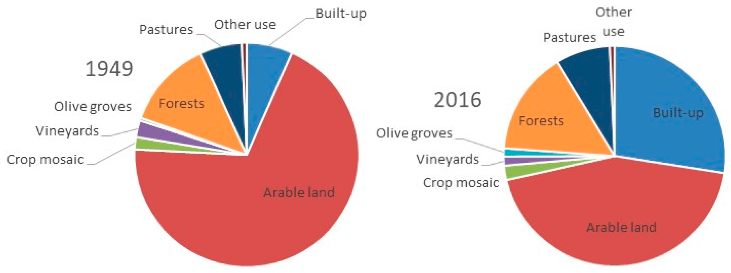
Figure 1. Main forms of urban structure.
Ijgi 10 00231 g001
Figure 2. (a) Italy subdivided into 20 regions (NUTS Level 2, Nomenclature of territorial units for statistics—regions level) and the study area including the municipalities of Rome and Fiumicino within the Latium region (in purple); (b) Land cover map of the study area derived from the Corine Land Cover 2012—Level 1.
Ijgi 10 00231 g002
Figure 3. Basic forms identified by the MSPA analysis (core, islet, bridge, loop, branch, edge, and perforation areas. This image was adapted from the paper of Yu et al. [59] where the acronym UHI stays for Urban Heat Island but the concept can be easily generalized for any type of land cover map. (A) The image background pixel color is grey and identifies non-UHI, whereas the black pixel identifies UHI; (B) Different types of UHI in the context of the MSPA classification are shown.
Ijgi 10 00231 g003
Figure 4. Landscape composition (%) by year considering eight land-use classes.
Ijgi 10 00231 g004
Figure 5. Biplot of a Principal Component Analysis investigated similarities and differences in the spatial distribution of the average patch size (ha) by land-use class and morphological category; (a) 1949, (b) 2016.
Ijgi 10 00231 g005
Table 1. Landscape composition (%) by year in the study area (four classes); other use includes wetlands, water bodies, rocks, sand; rate of growth was calculated as annual per cent change over time.
Class19492016Rate of Growth
Built-up area6.628.95.0
Agricultural systems, pastures81.558.3−0.6
Forests11.212.00.1
Other use0.70.7-
Table 2. ‘Core’ area (%) and annual changes (%) by year and land-use class (difference was calculated as annual per cent change over time).
Class19492016Differences
Built-up area34.935.70.03
Arable land61.635.7−0.63
Crop mosaic17.15.4−1.02
Vineyards43.08.5−1.20
Olive groves14.03.1−1.16
Pastures25.26.5−1.11
Forests36.629.2−0.30
Table 3. Average patch size (ha) of built-up areas by morphological class and year (difference was calculated as annual per cent change over time; statistics is the level of probability associated with a non-parametric Mann Whitney U-test checking for similarity in patch size over time; * indicates significant differences at p < 0.05 after Bonferroni’s correction for multiple comparisons).
Class19492016DifferenceStatistic
Core20.316.2−0.38*
Islet0.91.40.53
Perforation6.06.10.02
Edge9.04.1−1.78*
Loop5.35.60.08
Bridge6.711.00.58*
Branch1.10.8−0.56
Publisher’s Note: MDPI stays neutral with regard to jurisdictional claims in published maps and institutional affiliations.

