
Design Verification of an Optimized Wayfinding Map in a Station


Department of Industrial Design, National Taipei University of Technology, 1, Sec. 3, Chung-hsiao E. Rd., Taipei City 10608, Taiwan
*
Author to whom correspondence should be addressed.
ISPRS Int. J. Geo-Inf. 2021, 10(4), 266; https://0-doi-org.brum.beds.ac.uk/10.3390/ijgi10040266
Submission received: 22 February 2021
/
Revised: 4 April 2021
/
Accepted: 12 April 2021
/
Published: 15 April 2021
Abstract
:Passengers were unsatisfied with the navigation signs in Taipei station based on the Report on the Taiwan Railway Passenger Survey. This study conducted two experiments. Experiment 1 involved 14 participants using the present Taipei Main Station floor map to wayfinding, plan routes, and provide route descriptions for four specified destinations in the station. All participants were requested to recall the route that had just been taken and draw a cognitive map. In Experiment 2, 14 other participants were asked to perform the same tasks as Experiment 1 but with the new map. This study’s results showed that the codes used by the participants in Experiment 1 revealed the differences in walking route distance and number of turns. Escalators and stairs that connected floors were often used as reference landmarks for wayfinding. In Experiment 2, the overall wayfinding performance of the participants was improved by using the new map. The wayfinding time was reduced and the time spent in wayfinding among users was more uniform, and their route planning strategies used became consistent. The new map that facilitates consistent action strategies among users and corresponds perfectly to the actual environment is able to create useful spatial knowledge for users.
1. Introduction
Wayfinding is a cognitive process that varies according to individual goals and in response to external environmental conditions [1]. Wayfinding can be divided into three specific but interrelated processes: decision making, decision execution, and information processing. Information processing is conducted on the basis of the decision making and decision execution processes [2,3,4]. People’s learning of the environment is serial stages of spatial development involving three forms of spatial knowledge, namely landmark knowledge, route knowledge, and survey knowledge [5].
Kuipers and Levitt [6] review several of their computational models of wayfinding in which spatial knowledge is said to exist in a hierarchy of multiple forms, including distinct procedural, topological, and metrical structures. The long-dominant framework for understanding this process posits the following sequence: knowledge is initially acquired, followed by knowledge, which is followed by knowledge. According to this, landmark knowledge is knowledge of distinctive objects or scenes stored in memory. Route knowledge is knowledge of travel paths connecting landmarks. Survey knowledge is configurational knowledge of the locations and extents of features in some part of the environment that is not limited to particular travel paths. Some conceptualizations posit special cases of landmarks (e.g., reference points, anchor points) that serve important roles in the organization of spatial knowledge [7]. A related issue is the question of the role cartographic maps play in spatial knowledge acquisition. Maps are the most efficient and effective way of commuting metric properties of larger scale places, especially configurations (shapes). Some have maintained that survey knowledge hardly develops much from direct experience alone but requires exposure to maps [8,9].
Kitchin and Blades [10] proposed three cognitive map architectures for users to confirm their location on cognitive maps, that is (1) egocentric: the viewer’s own position as the center point; (2) fixed: a fixed point as a reference point; and (3) coordinate: position of an element determined using an abstract coordinate system. People make decisions based on information about environmental characteristics, and these decisions must be translated into actions to reach their destination [11]. Understanding of the relationship between the environment and cognitive maps generated by individual differences can serve as a basis for designing maps. Among all wayfinding behaviors, landmark navigation is the tool most commonly used to guide direction. Landmarks play a critical role in daily spatial tasks for wayfinding and navigation [12,13,14,15]. In addition, “good” landmarks [16], i.e., visually prominent and familiar objects, may have recognisable logos and are located on the pedestrians’ route.
A landmark is eye-catching not only because of its own characteristics, but also its ability to be distinguished from similar objects in the environment [17]. Landmarks are crucial reference information when people are deciding the route direction [18]. Landmarks provide essential information at an intersection where direction change is required to continue the route, and help to create a visual model of key parts of the environment [9,10,11]. Significant landmarks must correspond to their environment’s attributes (e.g., color and texture), states (e.g., church or commercial building), or spatial location relative to other objects in the environment (e.g., town center) [12]. Provision of a landmark at a decision point affects the decision maker’s cognitive wayfinding strategies and facilitates positioning [5,14]. Landmarks should be used as the primary means of providing directions for pedestrians [19].
Golledge [1] argued that a landmark has two functions. First, it plays the role of an anchor, namely serving as a point that connects different regions in an environment. Second, it is used as an auxiliary tool for wayfinding, and wayfinders can use landmarks as a point of reference for direction identification and route decision. Successful spatial positioning occurs when a person’s brain can form an environmental cognition map to determine his or her location [11]. Once this information is available, the shortest and most efficient route from his or her current location to the desired destination can be quickly identified [20,21]. When no clear and correct decision is available, route selection is influenced by individual implicit strategies, which minimize the psychological and physical burden involved in wayfinding in the environment to the greatest degree [20,22,23,24,25,26]. These strategies include the following: the least-angle strategy, in which the route chosen is the one that deviates the least from the target direction [22,23]; and the initial segment strategy, which involves route selection based on the straightness of the initial segments of a route [27]. Landmarks have an essential role in the formation of cognitive maps or wayfinding process.
Wayfinding map design becomes complex when an indoor space offers horizontal and vertical movements. The functions of landmarks are to organize and connect spaces, and to be used as an auxiliary tool for wayfinding. Wayfinders can use a landmark as a reference point for direction identification and route decision. Map learning can only achieve favorable performance when the map’s initial direction is consistent with that of the environment [28]. Apelt [29] suggested that an efficient wayfinding map should have the following characteristics: (1) organize the environment into a clear space; (2) display all elements of the area while ensuring that it contains only essential and memorable connections to avoid capturing less essential details; (3) mark user’s current location; (4) orient the map to user’s direction; (5) ensure that any graphical communication used is clear and that any letters used are proportional to the layout to keep the map tidy; and (6) provide sufficient information to guide users to the next map or direction sign. Regarding people’s use of floor maps in unfamiliar buildings, a positive correlation was found between wayfinding performance and spatial learning [30]. Therefore, it is necessary to understand the user’s reading and exploration capabilities before map design.
Most studies focus on differences between individual intrinsic cognition and extrinsic wayfinding behavior, and few studies have applied such a difference to map design and verified its effectiveness. The main challenge is how to document users’ inner feelings systematically and how these feelings translate into design changes.
A study by Brosset, Claramunt, and Saux [31] attempted to construct a verbal route description model for wayfinding, established a semantic structure in the route description, and converted a logical verbal structure of sentences into a visual route description. Whether it contains a description of an action or a location, a landmark object or an open space might be mentioned in a speech. The locations where each wayfinding process begins and ends can be a landmark or open space; similarly, people pass through these landmarks or open spaces and use them as reference points in the wayfinding processes. These behaviors can be seen as interactions between people and space. Landmarks and spaces are crucial decisive nodes for people to orient in space. It may also be a location at which people take a short pause during actual walking to decide where to go next. So the action commands in verbal descriptions are dynamic components constituting a description, which is then expressed in verbs. Among the speech structures generated during wayfinding, nodes represent various locations on the route, and edges represent actions that connect to these locations. Brosset et al. proposed a simplified and intuitive route representation that has the most basic composition of route descriptions and more clearly presents the location-action-location process, symbolizing the movement through the starting and ending points the respondent’s semantic structure when conducting route descriptions. An action command may contain descriptions of cardinal directions or relative directions; route descriptions may also contain stereoscopic vocabulary expressions. This model helped researchers understand people’s verbal description method and trans-formed the semantic structure into visual expressions. When understanding the wayfinding plans in different sites, recognizing patterns in speech content and determining the semantic structure are conducive to revealing a space’s vital landmarks.
For this reason, we will take researched path description model for wayfinding and discuss the needs of users’ wayfinding behaviors and the potential problems of wayfinding in Taipei Main Station. At present, passengers were unsatisfied with the navigation signs, such as the wayfinding map in Taipei station, based on the Report on the Taiwan Railway Passenger Survey. A new map design was proposed by analyzing and defining the original map design conditions of the site. Finally, design verification was performed to provide references for the design of related maps in the future.
2. Materials and Methods
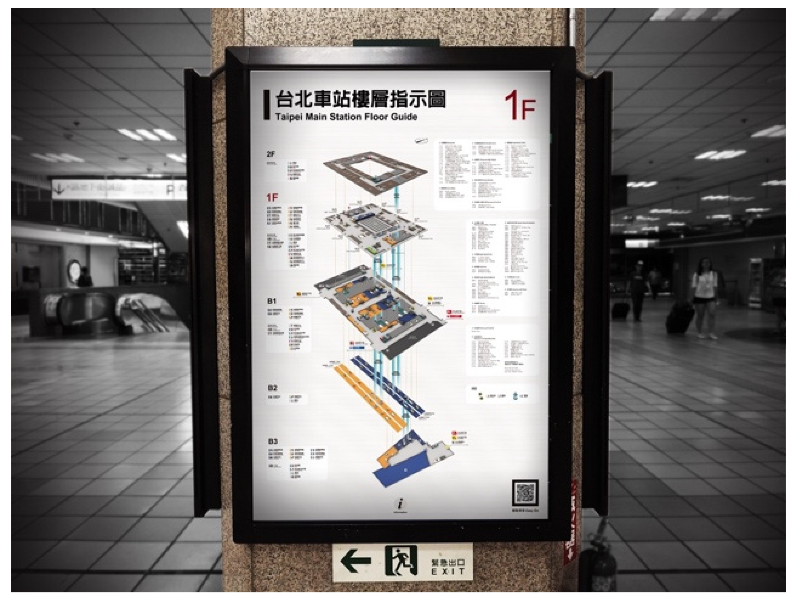
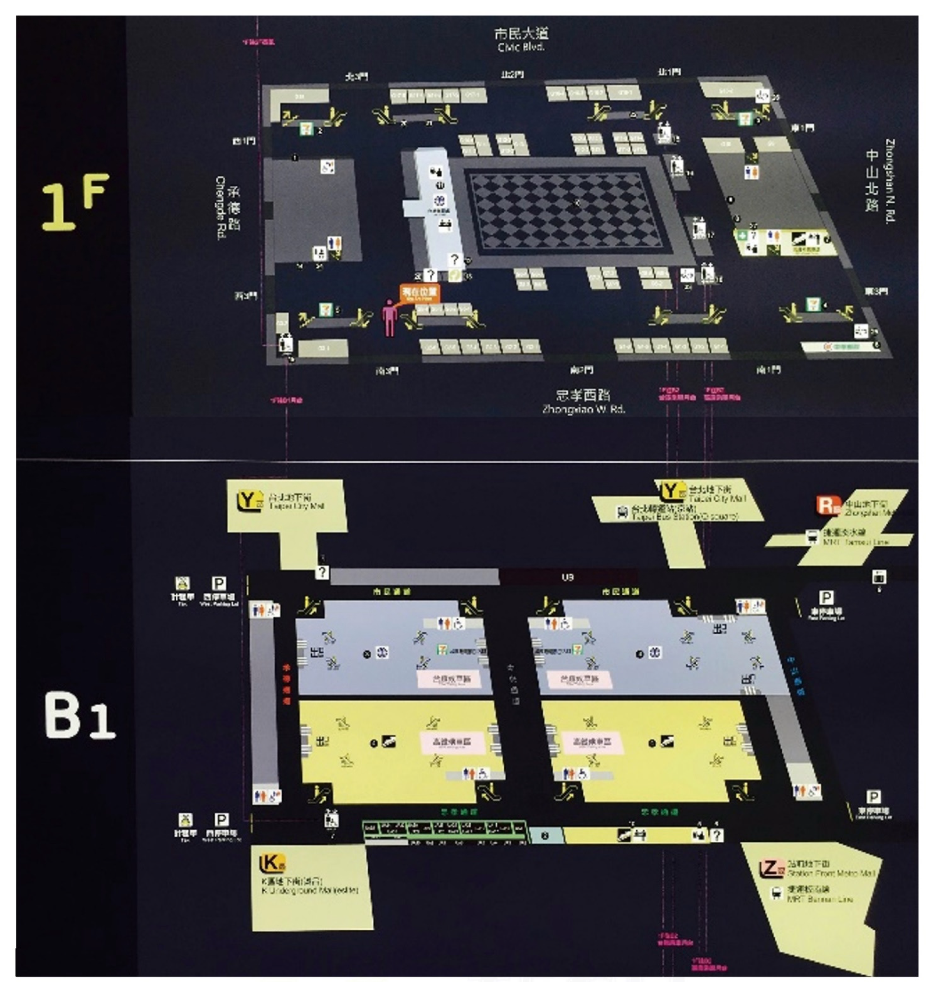
The research site is Taipei Main Station, which is the largest railway station and has the highest capacity in Taiwan. The main areas used by passengers in Taipei station are 1F and B1. There are eight staircases, twenty-six escalators, and four elevators. The stores are concentrated in 1F, with 57 stores. A total of eighty-one stores and twelve toilets are on two floors. There are 42 maps on 1F and 36 maps on B1. All the maps are posted on the four sides of the pillar. The main body of the station is a 149-m-long and 110-m-wide building with six floors above ground and four floors underground. According to the observations, map pillars with the highest usage rates are used as a model map for experiments (Figure 1). A total of 28 participants, who were out-of-towners freshmen, about 18 to 19 years old with low experience in Taipei station, joined in two experiments. Fourteen participants participated in each experiment. We asked subjects to think aloud while they were moving, and a voice recorder on their body recorded all of their words. At the same time, we took photos from the rear to record the relationship between their thoughts and location. Before the experiment began, we asked subjects to try using the phrase “What do I see, how do I feel, and what actions should I take” for their next think-aloud. After completing the task, we replayed the recording video to reconfirm all of the respondents’ opinions.
2.1. Experiment 1
Four locations within the station were selected for target finding, route planning, and route description tasks. The four locations are distributed on the east, west, south, and north sides of the first floor and basement-one (B1) level. A think-aloud method was used to record the wayfinding process of the participants, and think-aloud content was coded (Brosset et al., 2007). The four tasks are as follows:
- Task destination 1: Northeast entrance to the east underground parking lot of Taipei Main Station (B1 floor).
- Task destination 2: Chunghwa Post located next to the entrances South 1 & East 3 (1st floor)
- Task destination 3: West exit of the railway platform (B1 floor)
- Task destination 4: Railway information center (1st floor).
The reason for the four tasks set up is so that the subjects could move up and down two floors (1F and B1) of the station, and walk around the station as much as possible. A total of 14 participants with low experience in Taipei station were recruited and asked to determine the locations of the four destinations on the experimental map according to the destination locations. Subsequently, the participants were asked to plan the routes to the four destinations based on their current location, and the map was asked to be returned after the routes were determined. Finally, without time limit imposed for wayfinding, the participants were asked to depart from the starting point and complete the four tasks in sequence. Each stage of the experiment began when the participants received a command and ended when they moved on to the route to the next task destination. All participants were asked to express their feelings when they made judgement on or were confused about the current situation. At the end, the participants were asked to recall the route that has just been taken and drew a cognitive sketch map.
2.2. Experiment 2
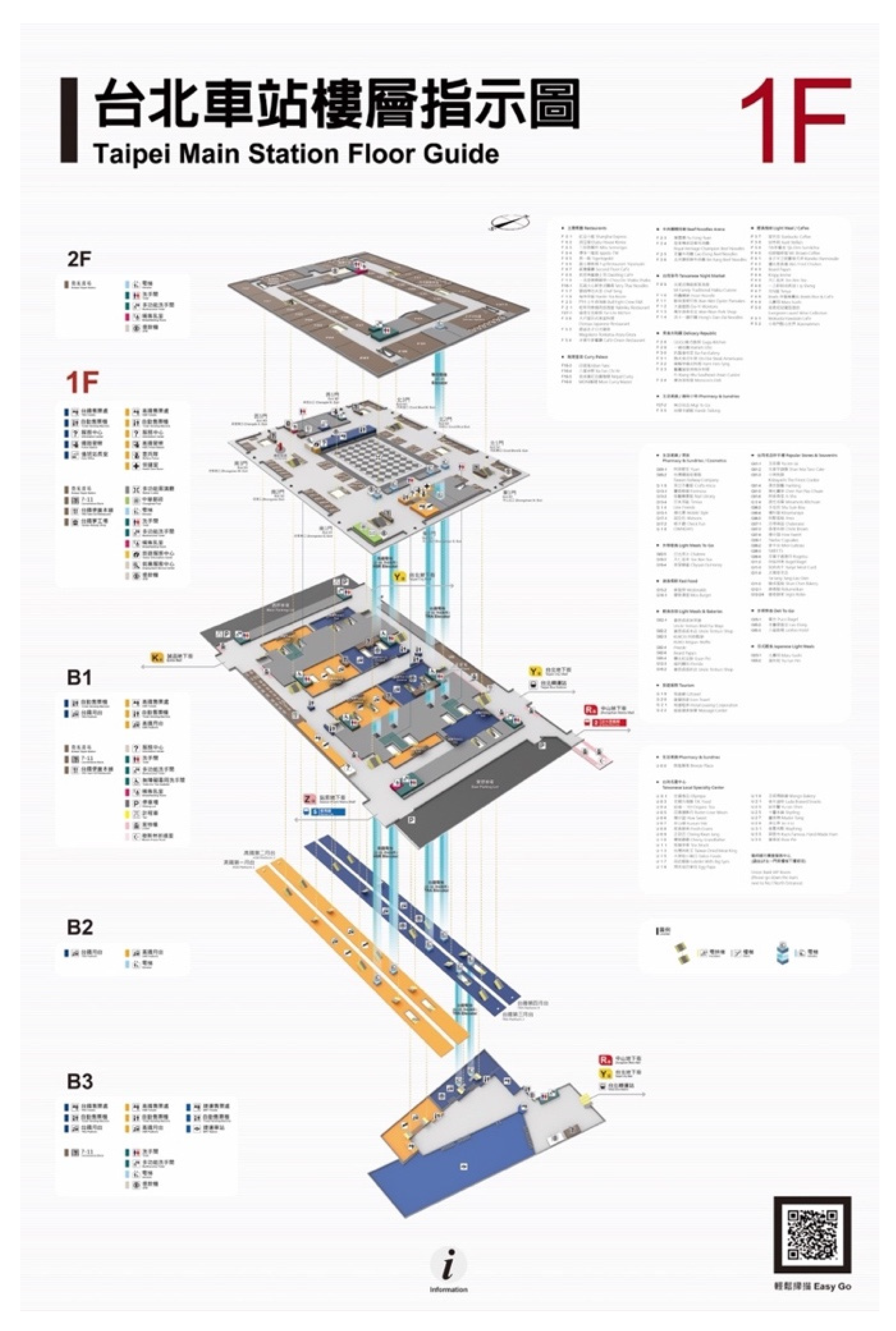
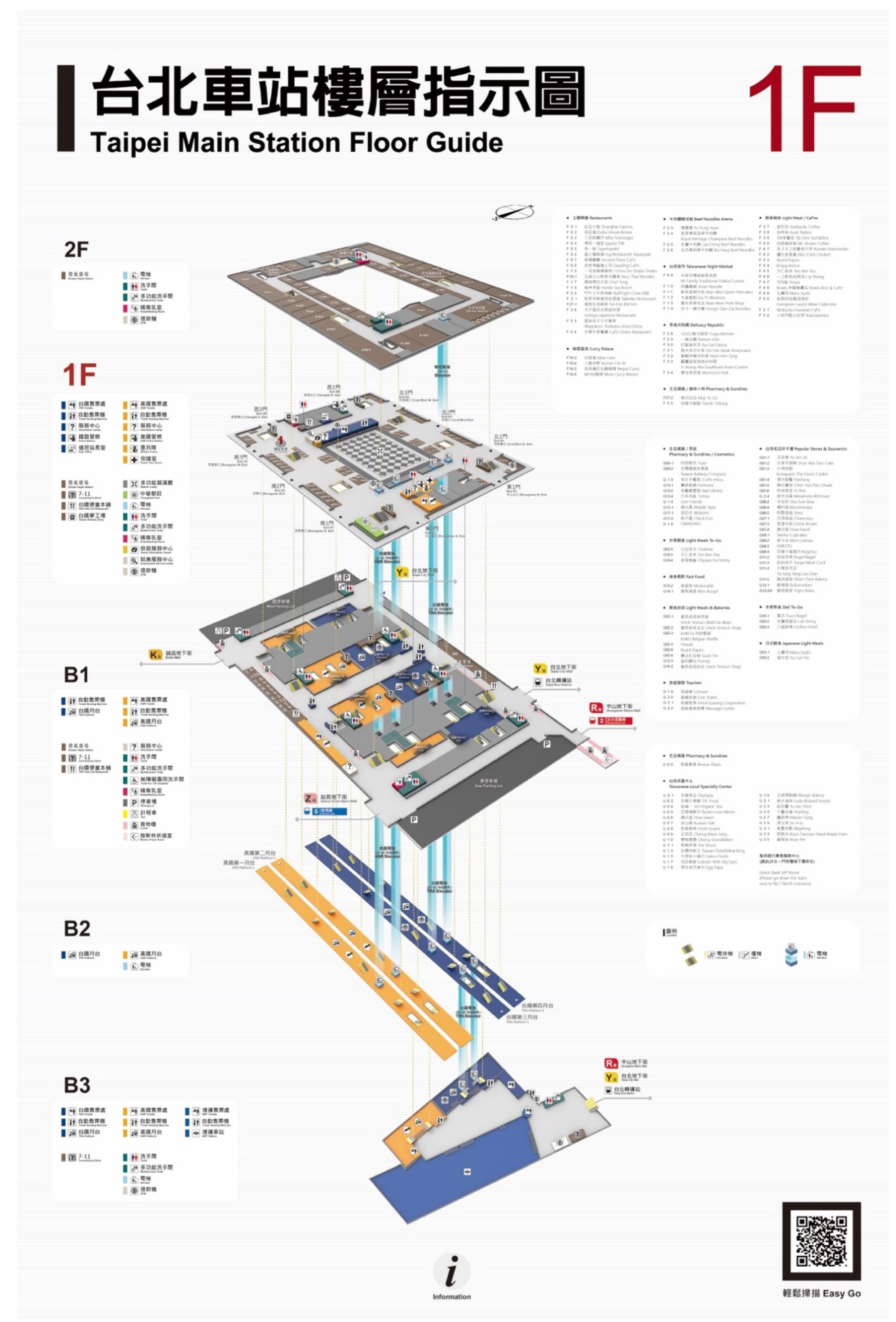
Based on the results of Experiment 1, this study redesigned a new map. The size of the proposed map was the same as that of the map lightbox on the first floor of the station, which is 100 cm in width and 150 cm in length. The study designed a new Taipei Main Station Floor Guide map, which consisted of maps of two floors aboveground and three floors underground. The new map was divided into three areas, which from left to right were icon legend for crucial landmarks, map information, and floor signs, shop information, icon legends of stairs, escalators, and elevators, and a two-dimensional QR code (Figure 2). In Experiment 2, another 14 participants were requested to complete the same four-stage wayfinding tasks, whose results were used to compare the differences in participant wayfinding behaviors before and after the new map design.
We asked subjects to think aloud while they were moving, and a voice recorder on their body recorded all of their words. At the same time, we took photos from the rear to record the relationship between their thoughts and location. Before the experiment began, we asked subjects to try using the phrase “What do I see, how do I feel, and what actions should I take” for their next think-aloud. After completing the task, we replayed the recording video to reconfirm all of the respondents’ opinions.
3. Results
3.1. Experiment 1
The experimental results were divided into four parts, namely route planning descriptions, wayfinding process, drawing of cognitive maps, and post-interviews.
The results were classified according to the participants’ speech content used in the route planning (Table 1 and Table 2). The route descriptions most used by the participants were the indoor landmarks (WD-5), entrance and exit names (WD-6), left and right sides (WD-2), and destinations (WD-8). The indoor landmarks in the map can effectively help the participants to identify their locations relative to the surroundings; entrances and exits in the station also have the same function.
Total usage numbers of speech codes used in Tasks 1 and 3 were higher than those in the other two tasks. The starting points and destinations of Tasks 1 and 3 were both located diagonally to each other in the station. The route distance and number of turns were both larger than those of the other two tasks. In addition, the participants predominantly used entrances and exits at the east, west, south, and north (WD-6) on the first floor in Taipei Main Station as the reference landmarks for navigation in the indoor space. According to the speech results described by the participants in the process of completing the tasks, the walking distance along the planned route and number of turns were the factors affecting route planning.
According to the number of landmarks used by the participants during wayfinding across the two floors in Taipei Main Station, the results showed that escalators or stairs connecting the two floors and entrances, exits, 7-Eleven, station concourse, and railway ticket hall on the first floor were often used to help remembering the route.
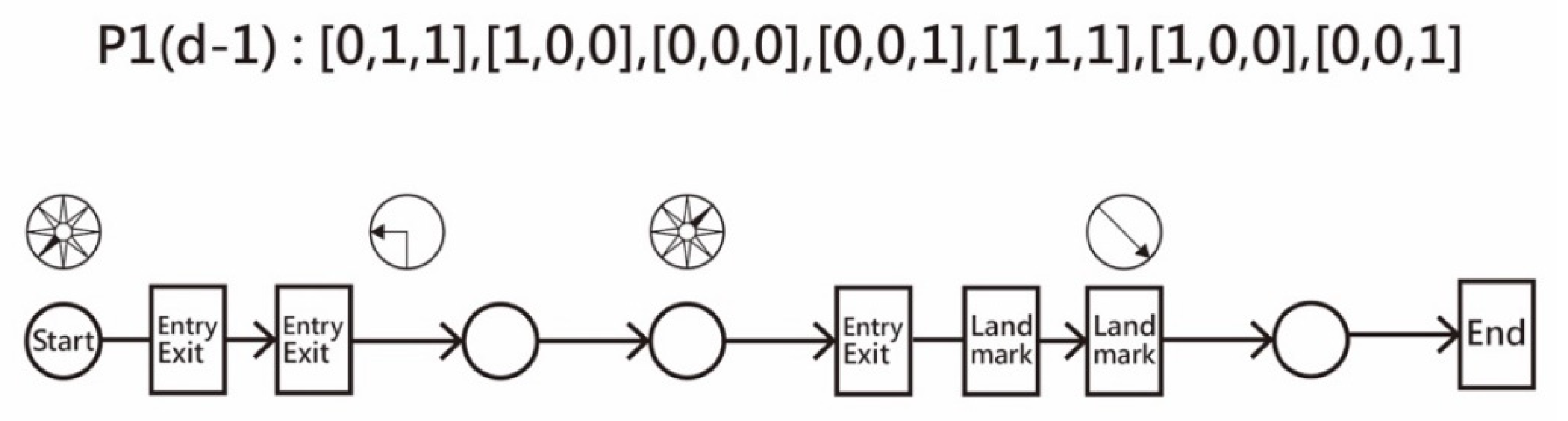
This study graphically converted text of each participant’s speech to codes based on Brosset’s study (Table 3). The content of each participant’s speech can be transformed into a visual route description model by using this method. For example: “Now I am in the southwest, first walk in the opposite direction of the West Gate to the East Gate, then turn left when you see the East Gate, then walk to the northeast location, so you will first come to the East Gate, there is a 7-11 nearby, go down the 7-11 escalator, and then you will come to B1 and maybe go back, you will see the parking lot.” The first part, “now I am in the southwest, go first in the opposite direction of Xisanmen to East Sanmen,” is an action that begins at a place that is regarded as an indoor landmark or open space (“southwest”) and ends at an indoor landmark or open space (“East Sanmen”). In the end, the routing plan includes 8 Nodes and 7 Edges, as well as six indoor landmarks (West Gate, East Gate, East Gate, 7-11, Escalator, and Parking Lot) (Figure 3).
For the 14 participants in Experiment 1, 56 speech structures from Tasks 1–4 were classified into five categories, namely three edges, four edges, five edges, seven edges, and nine edges (Brosset et al., 2007).
Participants’ speech structures in Task 1 mainly comprised four edges, indicating that participants usually described the route for Task 1 with four sentences. In the speech structures of Task 2, the structure comprising five edges appeared the most. Among the speech structures of Task 3, those with seven edges appeared the most. In these route planning descriptions, approximately 50% of the speech content was constituted by crucial indoor landmarks and dynamic movement commands in the station. In the speech content of Experiment 1, 69.6% of the content was accounted for by indoor landmarks or open spaces. The participants tended to use indoor landmarks or open spaces as references for memorizing the routes and identifying destinations during wayfinding in the actual station space.
“Now I am in the southwest, first walk in the opposite direction of the West Gate to the East Gate, then turn left when you see the East Gate, then walk to the northeast location, so you will first come to the East Gate, there is a 7-11 nearby, go down the 7-11 escalator, and then you will come to B1 and maybe go back, you will see the parking lot.”
In Experiment 1, codes used by the participants were as follows in descending order of the number of use: indoor landmark (WD-5), entrance and exit names (WD-6), left and right sides (WD-2), and destination (WD-8). The actual routes taken by the participants in Task 1 were different from the planned route. Although they successfully arrived at the destination, it can be seen that the information provided by the map did not fully correspond to the actual space in the station environment. Participants’ actual walking routes in Task 2 were consistent with the planned route. The starting and ending points in Task 3 were located diagonally to each other in the cross-floor space. Signs of getting lost and confused were frequently observed at the intersections near the destination, namely the west exit of the railway platform. In Task 1, cognitive maps drawn by the 14 participants were found to be 93.64% conformant to the walking route; maps were 94.75% conformant in Task 2; maps were 91.57% conformant in Task 3; and all participants successfully completed Task 4. Numbers of indoor landmarks or open spaces that the participants used as references and added to their cognitive maps increased as they proceeded to each stage; at least one reference was added to the maps in each stage.
3.2. Postexperiment Interview
After completing the task, we replayed the recording video to reconfirm all of the respondents’ opinions. When we replayed a film and found that the subject hesitated, we asked them why they were hesitant: because they can’t identify any signage or environmental objects? Did they have any strategy for planning this route? Six participants reported that they could not intuitively identify the relative positions of escalators, and that the depicted numbers of escalators were also inconsistent with those on site. No abnormalities were identified when the participants were planning their routes; but they felt anxious when they noticed there the actual space was different from that they expected. Escalators or stairs were the most used reference landmark when moving between floors in Taipei Main Station during the wayfinding processes. Therefore, how the icons (e.g., escalator) could be accurately expressed on the map was the primary aspect to be improved in the new map design. In addition, due to the complex environment of B1, nine participants mainly worked from the first floor when planning their routes and used the entrances and exits of the station as their bases for judgment.
3.3. Map Design Proposal
The post-wayfinding interview in Experiment 1 revealed that the participants considered that the B1 floor was much more spatially complicated than the first floor. Therefore, the main floor of the map was selected to be the B1 floor, which is the middle floor of all five floors. The main entrance is set to be the one located on the south side of the station. This study suggested that crucial indoor landmarks on the first floor, such as the station concourse and ticket hall, face the users. A 45-degree perspective was used as the drawing angle of the new Taipei Main Station Floor Guide for optimal legibility of each floor. Vital landmarks and functional areas in the station were divided by elevating objects at certain heights on the map. Therefore, this study defined two heights of objects, 8 or 5 mm, on the map, and the height of an object indicated the importance of the object. A typical 8-mm landmark object was the most indicative indoor landmark in Taipei Main Station. A typical 5-mm object was the secondary reference landmark when participants were planning the route, including the restrooms, breastfeeding rooms, elevators, 7-Eleven, post office, duty room, etc. Finally, the boundaries of the station space and control office area were elevated at a height of 2.5 mm to signalize the area division.
Furthermore, the numbers and relative positions of escalators and stairs shown on the map were different from those in the actual environment. Therefore, in the presentation of elevators, elevators, and staircases on the new map, a vertical directional guide passage was added between the floors, indicating how they moved between floors, thus enabling users to accurately locate elevators. Finally, the compass icons were also designed with a perspective so that map users could easily correspond the map to the actual environment.
In the new map, the relative spatial relationship among escalators, elevators, stairs, and floors were enhanced; the direction of each icon in the space can help people to understand the direction toward and orientation of exits after using escalators. The new map retained the spatial characteristics of all entrances and exits on the first floor. The researchers paid close attention to the distance between each indoor landmark object on the map to ensure that every area on the map contained at least one landmark object. Relative to the old map, the new map strengthened the existing icons of indoor reference landmarks and areas, so that the map presented spatial appearance comparable to the complex environment of the B1 level, thus more effectively reflecting the actual environment.
A design verification of the new Taipei Main Station Floor Guide was performed by conducting Experiment 2. Similarly, 14 participants were requested to complete the same four-stage wayfinding tasks (Figure 4). The differences in user’s wayfinding behavior between using the new and old maps were analyzed, after which the design evaluation and its feasibility were proposed.
4. Discussion
Investigating the participants’ speech structures with regards to the speech edges, this study revealed that participants’ use of speech structures was diverse in Experiment 1, whereas they predominantly used two speech structures in Experiment 2. The results indicated that participants’ memorizing methods were more consistent in Experiment 2 than Experiment 1.
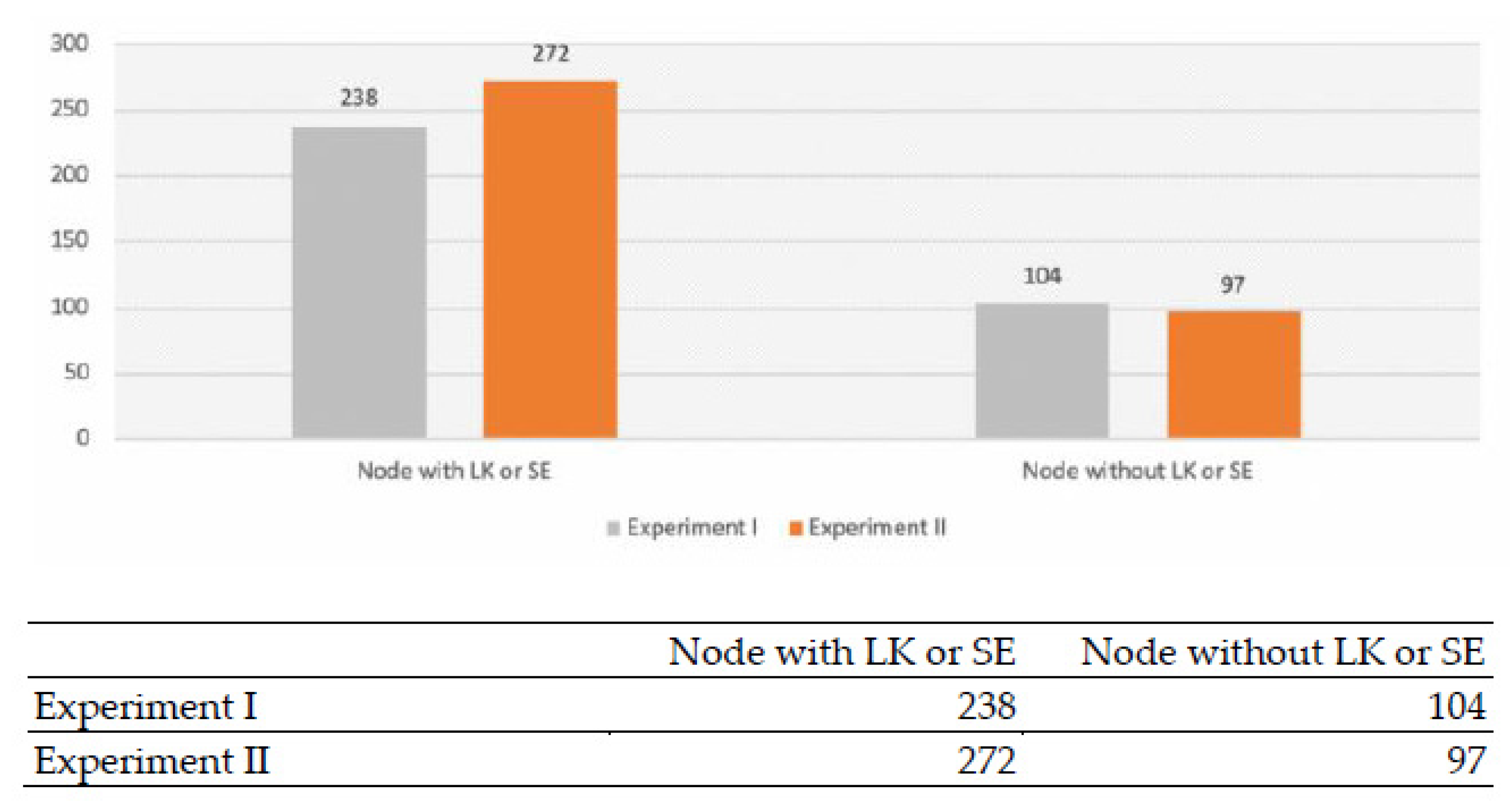
During wayfinding in the space within Taipei Main Station with the new map, the participants tended to use larger proportions of references constituted by landmarks and spatial objects. The results showed that reference landmarks and objects together were mentioned in the participants’ speech content for 272 and 238 times in Experiment 2 and Experiment 1, respectively. The landmark icons in the new map were shown to be conducive to the memorizing process before wayfinding (Figure 5).
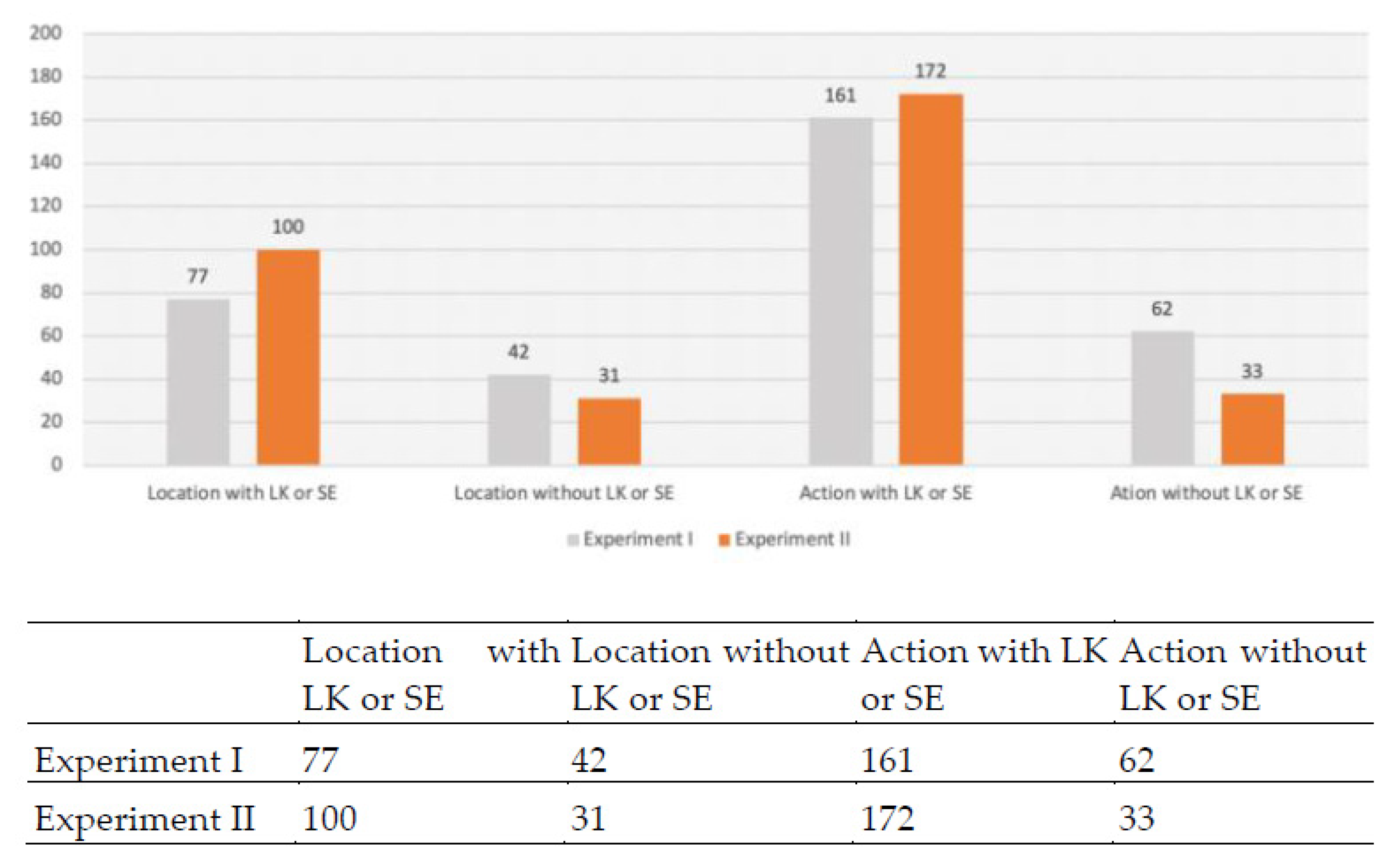
Of all route descriptions, those containing action and location commands with reference to landmarks or open spaces (Location/Action with LK or SE) were the most used by participants in the experiments. In Experiment 2, the use of route descriptions containing location increased by 4.6% relative to Experiment 1. Labels of essential indoor landmarks and spaces on the new map facilitate higher ease of use (Figure 6).
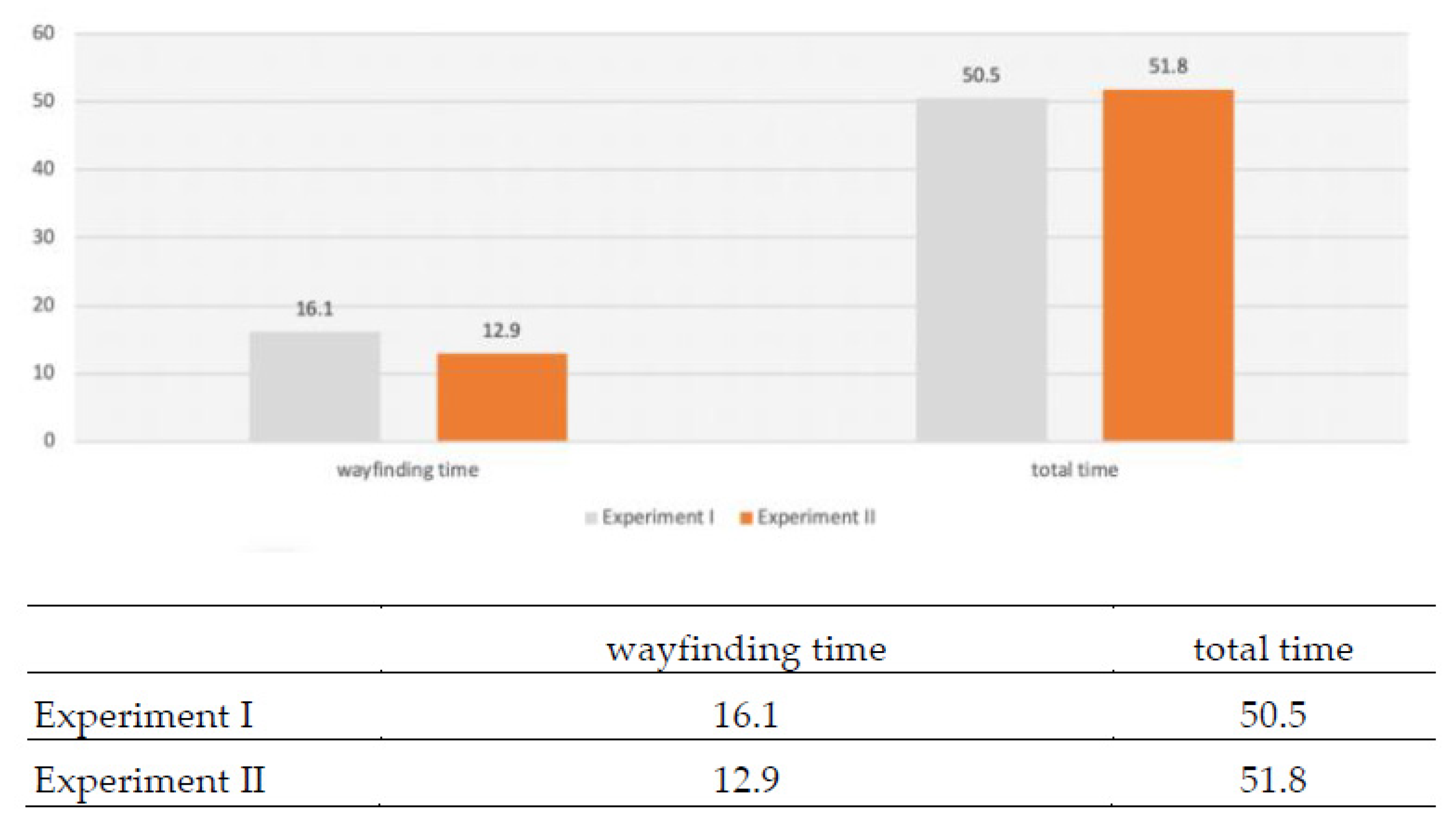
The average wayfinding walking times of Experiments 1 and 2 were 16.1 and 12.9 min, respectively (Figure 7). The new map provided participants more knowledge of the station environment and thus enabled them to walk around in the Taipei Main Station more easily. On average, participants in Experiments 1 and 2 referred to 13 and 15.5 crucial indoor landmarks and reference objects, respectively during wayfinding. The new map layout enabled the participants to identify and use more landmark objects as reference during wayfinding, thus assisting the participants in completing the tasks successfully.
In each task, the participants’ actual walking routes were nearly 100% conformant to their cognitive maps, suggesting that the participants had improved compared with Experiment 1. The new Taipei Main Station Floor Guide design was closer to what the participants expected. With the new map, participants were more confident in identifying the reference landmarks when walking in the station (Figure 8).
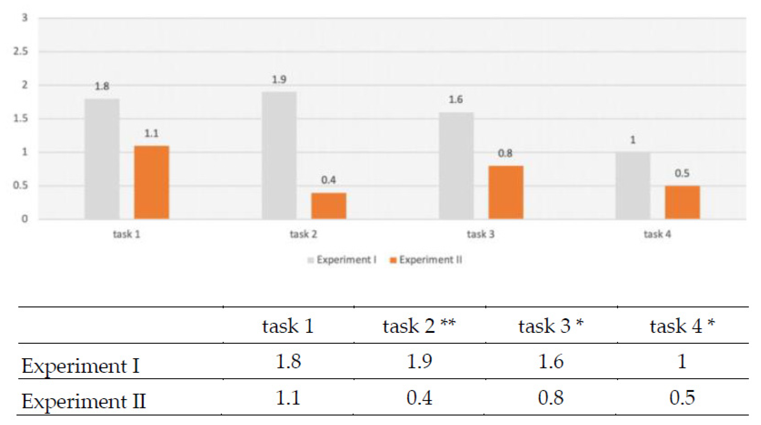
On the cognitive map for Experiment 2, the participants could accurately draw the referenced objects in the wayfinding process compared with Experiment 1, and thus number of landmark references that need to be added in the cognitive map was relatively low. Especially in Task 2 (p = 0.0001, F = 9.279), Task 3 (p = 0.0120, F = 3.735) and Task 4 (p = 0.04, F = 2.737), the number of landmarks used decreased significantly based on F-test in one-way ANOVA. Compared with the old map, the spatial appearance of Taipei Main Station shown on the new map was more in line with the participants’ cognitive maps, and thereby the wayfinding performance was improved (Figure 9).
The east, west, south, and north entrances and exits on the first floor of Taipei Main Station, which were frequently used as reference by the participants were less adopted in Experiment 2. This result indicated that the new map included more indoor landmarks, landmark objects, and surrounding environment depictions. In Experiment 2, the proportions of code use of left and right sides (WD-2) and left and right turns (WD-3) were increased, indicating that the participants demonstrated improved understanding of the appearance of the entire station space, showed greater ability to use the relative position of landmark objects to understand the surrounding environment, and used left and right directions to identify the destination. The new map enabled the participants to plan more diverse routes and became less reliant on certain landmark objects; they started to understand the spatial relationships among the spaces in the station according to the position of landmarks relative to the overall environment. The spatial depiction on the new map was closer to the actual appearance of Taipei Main Station, and the codes adopted by participants when using the new map were more evenly distributed throughout their route descriptions. The proportions of speech content constituted by the descriptions of indoor landmark or open space were 69.6% and 73.7% in Experiments 1 and 2, respectively. The new map design focused on the graphical representation of landmark objects and highlighted these objects on the map. The experimental results showed that the originally essential wayfinding elements maintained their high frequency of use even after various improvements. Moreover, regarding the distribution of use of indoor landmarks and open spaces as reference throughout participants’ route descriptions (from the beginning to the end), such distribution for Experiment 2 was more uniform than that for Experiment 1. The average walking time during wayfinding for Experiment 2 was 3.2 min faster than that for Experiment 1, indicating improved wayfinding performance in Experiment 2. In addition, the average numbers of referenced indoor landmarks and spatial objects for Experiment 2 were also higher than those for Experiment 1. This indicated that, compared with the old map, more landmark objects can be effectively identified on the new map, hence used by the participants to complete the four tasks more successfully.
The attentional processing of landmark representations gradually decreases with an increasing distance to the route, decision points, and potential decision points. In maps with low visual complexity, landmark representations further away from the route are fixated. Map users might require a certain amount of reference points to form spatial relations as a foundation for a mental representation of space. Visual complexity of the area displayed in a map should be considered in navigation-oriented map design by increasing displayed margins around the route in maps with a low visual complexity [32]. Due to a large amount of information on the map, the road signs corresponding to the real environment are well used as reference points and marked on the map.
5. Conclusions
This study optimized the Taipei Main Station Floor Guide by route planning and actual wayfinding tasks. Experiment 1 showed that codes used by the participants in their route descriptions differed depending on the settings of the four experimental routes, including the distance of planned walking route and number of turns. These different codes used also led to differences in how participants read map, planned routes, and wayfinding. Escalators and stairs that connect floors were often used as reference landmarks for wayfinding. However, the participants were not satisfied with the numbers of landmarks and the graphical representation of their relative positions on the existing map. Therefore, this study established the design specifications for a new map, namely the floor plan perspective and three-dimensional presentation, based on the Experiment 1 results of the codes and reference landmarks used by participants in their route planning and the post-interviews to improve the ease of reading and memorizing. Designing a new Taipei Main Station Floor Guide, this study not only maintained the original wayfinding efficiency, but also narrowed the individual differences of users and established an efficient behavioral model. According to the design verification results in Experiment 2, overall wayfinding performance of participants was effectively elevated with the new map. Apart from reduced wayfinding time, the wayfinding time among participants was more uniform, and the route planning strategies used by participants became more consistent. The new map effectively explained the spatial configuration in the station through the positions of landmarks relative to the overall environment. The high comparability between the map and the actual environment facilitated effective route exploration and the attainment of useful spatial knowledge. The new map has indeed taken all the signs of the current environment into account. However, there are too many visual guides in the station, so this study only focuses on map reading and wayfinding. We will review whether the new map’s location and presentation will help users move around the station.
Author Contributions
Meng-Cong Zheng contributed to the original ideas of the paper and designed the experiments. Ken-Tzu Chang performed the experiments and analyzed the experimental data under the supervision of Meng-Cong Zheng. Ken-Tzu Chang wrote the first draft of the manuscript; Meng-Cong Zheng revised and edited it. All authors have read and agreed to the published version of the manuscript.
Funding
This research received no external funding.
Data Availability Statement
Due to confidentiality agreements, supporting data can only be made available to bona fide researchers subject to a non-disclosure agreement. Details of the data and how to request access are available from Meng-Cong Zheng([email protected]) at National Taipei University of Technology.
Acknowledgments
Special thanks for all participants and Taiwan Railways Administration who generously shared their time and experience, for the purposes of this study sections.
Conflicts of Interest
The authors declare no conflict of interest.
Appendix A
Figure A1.
Present map made by Taipei station.

Figure A2.
New map designed by the authors.

References
- Golledge, R.G. Wayfinding Behavior: Cognitive Mapping and Other Spatial Processes; Johns Hopkins University Press: Baltimore, MD, USA, 1999. [Google Scholar]
- Arthur, P.; Passini, R. Wayfinding—People, Signs and Architecture; McGraw-Hill: New York, NY, USA, 1992. [Google Scholar]
- Passini, R. Wayfinding in Architecture; Van Nostrand Reinhold: New York, NY, USA, 1984. [Google Scholar]
- Passini, R. Wayfinding: Backbone of graphic support systems. In Visual Information for Everyday Use: Design and Research Perspectives; Zwaga, H.J.G., Boersema, T., Hoonhout, H.C.M., Eds.; Taylor and Francis: London, UK, 1998; pp. 241–256. [Google Scholar]
- Siegel, A.W.; White, S.H. The Development of Spatial Representations of Large-Scale Environments. In Advances in Child Development and Behavior; Reese, H.W., Ed.; Elsevier BV: Burlington, VT, USA, 1975; Volume 10, pp. 9–55. [Google Scholar]
- Kuipers, B.J.; Levitt, T.S. Navigation and mapping in large-scale space. AI Mag. 1988, 9, 25–46. [Google Scholar]
- Presson, C.C.; Montello, D.R. Points of reference in spatial cognition: Stalking the elusive landmark. Br. J. Dev. Psychol. 1988, 6, 378–381. [Google Scholar] [CrossRef]
- Thorndyke, P.W.; Hayes-Roth, B. Differences in spatial knowledge acquired from maps and navigation. Cogn. Psychol. 1982, 14, 560–589. [Google Scholar] [CrossRef]
- Moeser, S.D. Cognitive Mapping in a Complex Building. Environ. Behav. 1988, 20, 21–49. [Google Scholar] [CrossRef]
- Kitchin, R.; Blades, M. The Cognition of Geographic Space; I.B. Tauris: London, UK, 2002. [Google Scholar]
- Casakin, H.; Barkowsky, T.; Kpippel, A.; Freksa, C. Schematic maps as wayfinding aids. In Spatial Cognition II: Integrating Abstract Theories, Empirical Studies, Formal Methods, and Practical Applications; Freksa, C., Brauer, W., Habel, C., Wender, K.F., Eds.; Springer: Berlin, Germany, 2000; pp. 54–71. [Google Scholar]
- Caduff, D.; Timpf, S. A framework for assessing the salience of landmarks for wayfinding tasks. Cogn. Process. 2006, 7, 23. [Google Scholar] [CrossRef]
- O’Neill, M. Effects of signage and floor plan configuration on wayfinding accuracy. Environ. Behav. 1991, 23, 553–574. [Google Scholar] [CrossRef]
- Richter, K.-F. A Uniform Handling of Different Landmark Types in Route Directions. Lect. Notes Comput. Sci. 2007, 4736, 373–389. [Google Scholar] [CrossRef]
- Tom, A.; Denis, M. Referring to landmark or street information in route directions: What difference does it make? In Spatial Information Theory. Foundations of Geographic Information Science; Kuhn, W., Worboys, M.F., Timpf, S., Eds.; COSIT 2003, Lecture Notes in Computer Science; Springer: Berlin/Heidelberg, Germany, 2003; Volume 2825, pp. 362–374. [Google Scholar]
- Burnett, G.; Smith, D.; May, A. Supporting the navigation task: Characteristics of ‘‘good’’ landmarks. In Proceedings of the Annual Conference of the Ergonomics Society, Turin, Italy, 7–9 November 2001. [Google Scholar]
- Martin, R.; Winter, S. Enriching Wayfinding Instructions with Local Landmarks; Springer: Heidelberg, Germany, 2002; pp. 243–259. [Google Scholar]
- Denis, M.; Pazzaglia, F.; Cornoldi, C.; Bertolo, L. Spatial discourse and navigation: An analysis of route directions in the city of Venice. Appl. Cogn. Psychol. 1999, 13, 145–174. [Google Scholar] [CrossRef]
- May, A.J.; Ross, T.; Bayer, S.H.; Tarkianen, M.J. Pedestrian navigation aids: Information requirements and design implications. Pers. Ubiquitous Comput. 2003, 7, 331–338. [Google Scholar] [CrossRef]
- Seneviratne, P.N.; Morerall, J.F. Level of service on pedestrian facilities. Transp. Q. 1985, 39, 109–123. [Google Scholar]
- Ueberschaer, M.H. Choice of routes on urban networks for the journey to work. Highw. Res. Rec. 1971, 369, 228–238. [Google Scholar]
- Dalton, R.C. The secret is to follow your nose: Route path selection and angularity. Environ. Behav. 2003, 35, 107–131. [Google Scholar] [CrossRef] [Green Version]
- Hochmair, H.; Karlsson, V. Investigation of preference between the least-angle strategy and the initial segment strategy for route selection in unknown environments. In Spatial Cognition IV: Reasoning, Action, Interaction; Freksa, C., Knauff, M., Krieg-Brckner, B., Nebel, B., Barkowsky, T., Eds.; Springer: Berlin, Germany, 2005; Volume 3343, pp. 79–97. [Google Scholar]
- Hölscher, C.; Meilinger, T.; Vrachliotis, G.; Brösamle, M.; Knauff, M. Up the down staircase: Wayfinding strategies in multi-level buildings. J. Environ. Psychol. 2006, 26, 284–299. [Google Scholar] [CrossRef]
- Wiener, J.M.; Mallot, H.A. ‘Fine-to-Coarse’ Route Planning and Navigation in Regionalized Environments. Spat. Cogn. Comput. 2003, 3, 331–358. [Google Scholar] [CrossRef]
- Wiener, J.M.; Schnee, A.; Mallot, H.A. Use and interaction of navigation strategies in regionalized environments. J. Environ. Psychol. 2004, 24, 475–493. [Google Scholar] [CrossRef]
- Bailenson, J.N.; Shum, M.S.; Uttal, D.H. The initial segment strategy: A heuristic for route selection. Mem. Cogn. 2000, 28, 306–318. [Google Scholar] [CrossRef] [PubMed] [Green Version]
- Richardson, A.E.; Montello, D.R.; Hegarty, M. Spatial knowledge acquisition from maps and from navigation in real and virtual environments. Mem. Cogn. 1999, 27, 741–750. [Google Scholar] [CrossRef] [PubMed] [Green Version]
- Apelt, R. Wayfinding in the Built Environment (Technical Report); Public Works Queensland: Brisbane, Australia, 2008. [Google Scholar]
- Hölscher, C.; Büchner, S.J.; Brösamle, M.; Meilinger, T.; Strube, G. Signs and maps–cognitive economy in the use of external aids for indoor navigation. In Proceedings of the 29th Annual Cognitive Science Society, Nashville, TN, USA, 1–4 August 2009; pp. 377–382. [Google Scholar]
- Brosset, D.; Claramunt, C.; Saux, É. A Location and Action-Based Model for Route Descriptions. In Proceedings of the International Conference on GeoSpatial Semantics Lecture Notes in Computer Science, Mexico City, Mexico, 29–30 November 2007; pp. 146–159. [Google Scholar]
- Keil, J.; Edler, D.; Kuchinke, L.; Dickmann, F. Effects of visual map complexity on the attentional processing of landmarks. PLoS ONE 2020, 15, e0229575. [Google Scholar] [CrossRef] [PubMed] [Green Version]
Figure 1.
Present map made for Taipei station. (Figure A1 in Appendix A).
Figure 1.
Present map made for Taipei station. (Figure A1 in Appendix A).
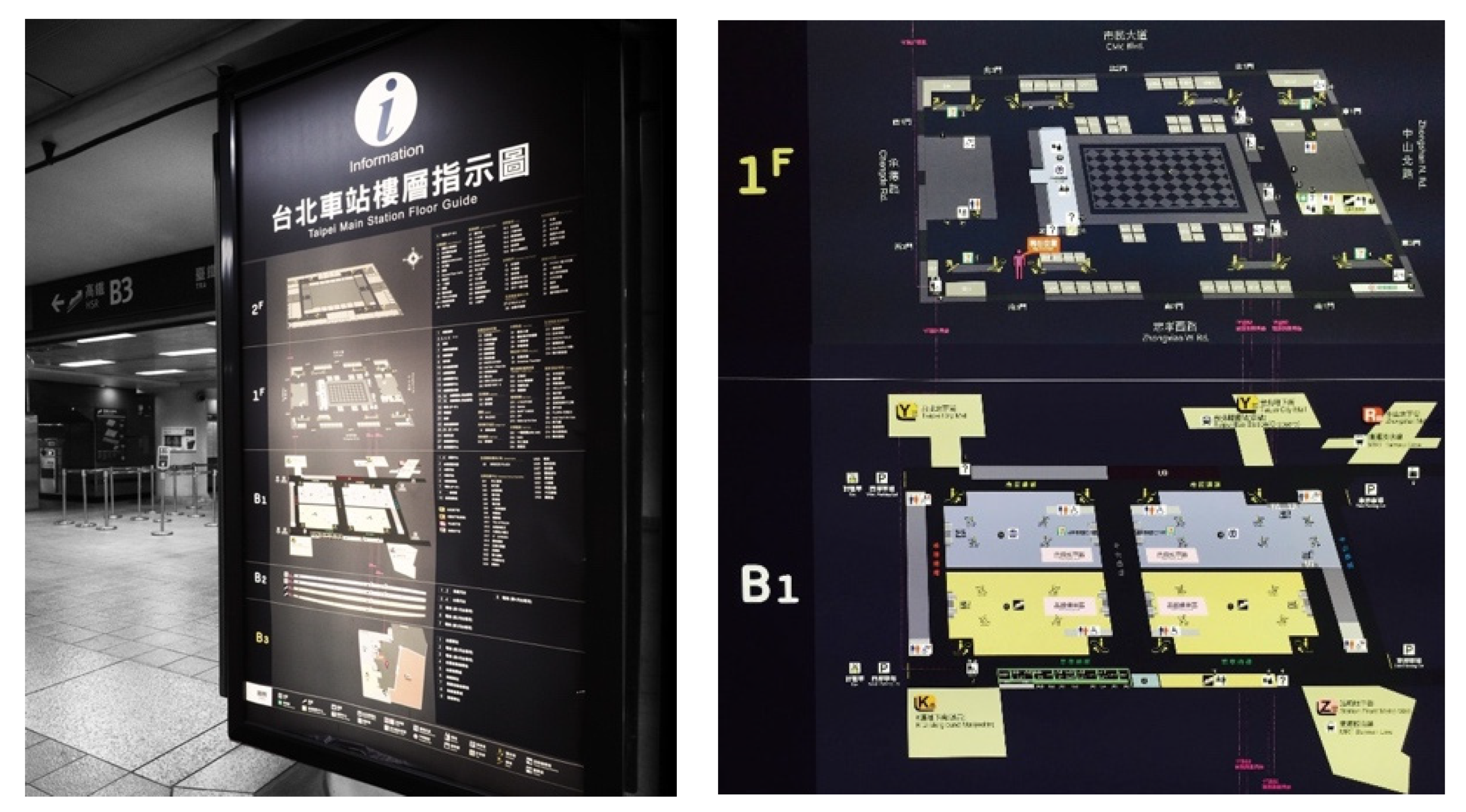
Figure 2.
New map designed by the authors. (Figure A2 in Appendix A).
Figure 2.
New map designed by the authors. (Figure A2 in Appendix A).

Figure 3.
Example speech structures transformed into visual route description model.

Figure 4.
Installed new maps.

Figure 5.
Node with/without LK or SE in two experiments.

Figure 6.
Location & Action with/without landmarks or open spaces (LK or SE) in two experiments.

Figure 7.
Wayfinding/total time in two experiments.

Figure 8.
Degree of conformity between cognitive map and actual wayfinding in two experiments.
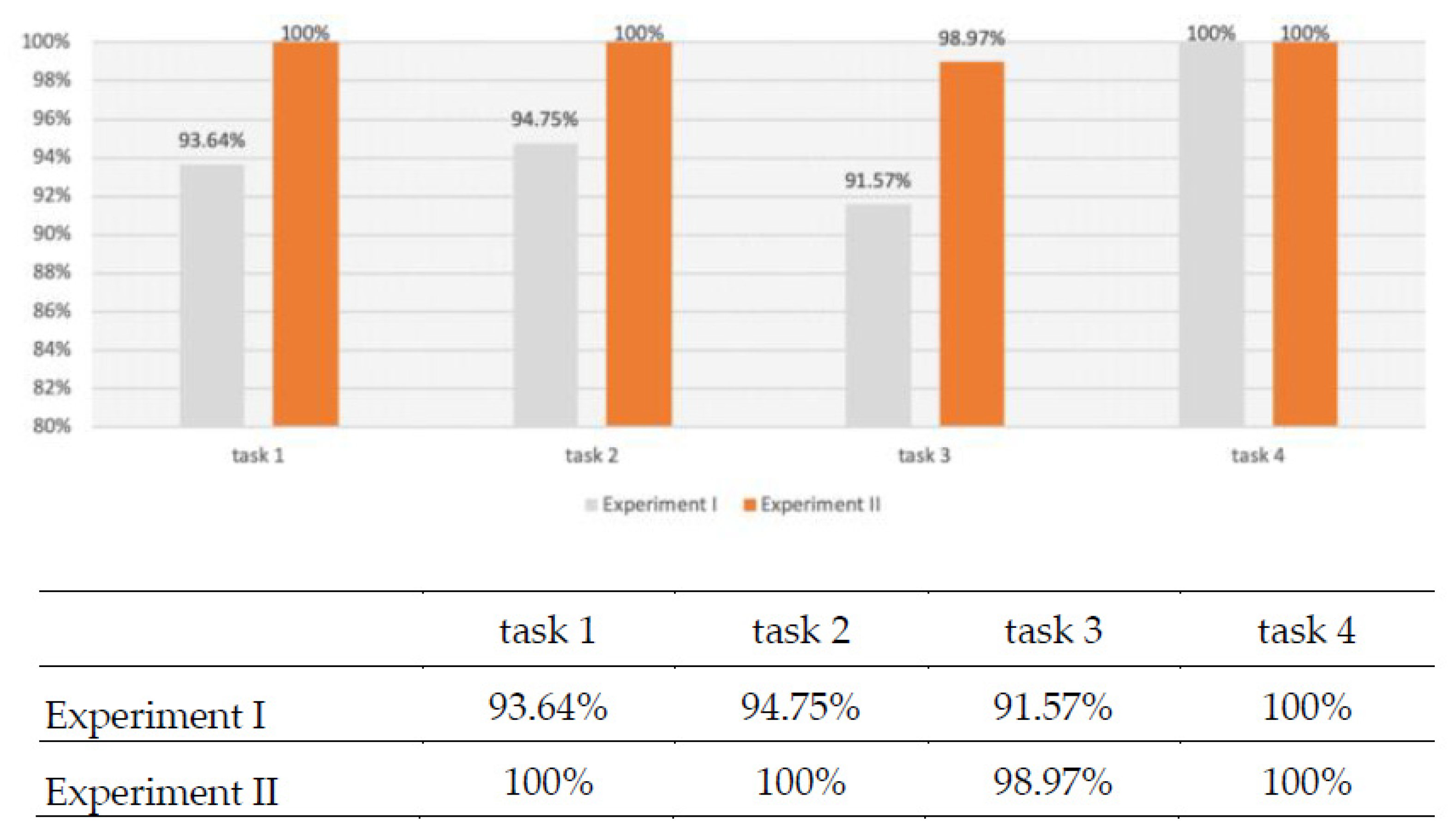
Figure 9.
Number of landmarks added between cognitive map and actual wayfinding in two experiments. (* p < 0.05, ** p < 0.01).
Figure 9.
Number of landmarks added between cognitive map and actual wayfinding in two experiments. (* p < 0.05, ** p < 0.01).


Table 1.
Coding classification.
| Coding Classification Diagram | |
|---|---|
| Current location |  |
| Left and right side | |
| Left and right turns | |
| Intersection | |
| Indoor landmark | |
| Entrance and exit name | |
| Orientation | |
| Destination | |
| Distance | |
| Route type | |
| Map orientation | |
| Turn backward | |
| Upper and lower floor code | |
Table 2.
Code of route descriptions.
| WD-1 | WD-2 | WD-3 | WD-4 | WD-5 | WD-6 | WD-7 | WD-8 | WD-9 | WD-10 | WD-11 | WD-12 | Total | |
|---|---|---|---|---|---|---|---|---|---|---|---|---|---|
| task1 | 5 | 8 | 9 | 1 | 36 | 17 | 4 | 9 | 0 | 1 | 0 | 1 | 91 |
| task2 | 5 | 8 | 3 | 0 | 23 | 8 | 6 | 11 | 0 | 5 | 3 | 3 | 75 |
| task3 | 7 | 8 | 11 | 1 | 33 | 13 | 3 | 9 | 0 | 3 | 0 | 1 | 89 |
| task4 | 5 | 15 | 6 | 1 | 39 | 6 | 2 | 10 | 0 | 2 | 0 | 1 | 87 |
Table 3.
Visual route description.
| No. | Definition | Notation | Icon |
|---|---|---|---|
| Sample-1 | An action that starts at a location and terminates at a location. | [0,0,0] |  |
| Sample-2 | An action that starts at a location and terminates at a landmark or a spatial entity. | [0,0,1] |  |
| Sample-3 | An action that starts at a location, qualified by a landmark or a spatial entity and terminates at a location. | [0,0,1] |  |
| Sample-4 | An action that starts at a location, qualified by a landmark or a spatial entity and terminates at a landmark or a spatial entity. | [0,1,1] |  |
| Sample-5 | An action that starts at a landmark or a spatial entity and terminates at a location. | [0,0,1] |  |
| Sample-6 | An action that starts at a landmark or a spatial entity and terminates at a landmark or a spatial entity. | [0,1,1] |  |
| Sample-7 | An action that starts at a landmark or a spatial entity, qualified by a landmark or a spatial entity and terminates at a location. | [0,1,1] |  |
| Sample-8 | An action that starts at a landmark or a spatial entity, qualified by a landmark or a spatial entity and terminates at a landmark or a spatial entity. | [1,1,1] |  |
Definition of Visual route description (Brosset et al., 2007).
Publisher’s Note: MDPI stays neutral with regard to jurisdictional claims in published maps and institutional affiliations. |
© 2021 by the authors. Licensee MDPI, Basel, Switzerland. This article is an open access article distributed under the terms and conditions of the Creative Commons Attribution (CC BY) license (https://creativecommons.org/licenses/by/4.0/).
Share and Cite
MDPI and ACS Style
Zheng, M.-C.; Chang, K.-T. Design Verification of an Optimized Wayfinding Map in a Station. ISPRS Int. J. Geo-Inf. 2021, 10, 266. https://0-doi-org.brum.beds.ac.uk/10.3390/ijgi10040266
AMA Style
Zheng M-C, Chang K-T. Design Verification of an Optimized Wayfinding Map in a Station. ISPRS International Journal of Geo-Information. 2021; 10(4):266. https://0-doi-org.brum.beds.ac.uk/10.3390/ijgi10040266
Chicago/Turabian StyleZheng, Meng-Cong, and Ken-Tzu Chang. 2021. "Design Verification of an Optimized Wayfinding Map in a Station" ISPRS International Journal of Geo-Information 10, no. 4: 266. https://0-doi-org.brum.beds.ac.uk/10.3390/ijgi10040266
Note that from the first issue of 2016, this journal uses article numbers instead of page numbers. See further details here.