
3D Visibility Analysis for Evaluating the Attractiveness of Tourism Routes Computed from Social Media Photos


Abstract
:1. Introduction
2. Related Research
3. Methodology
3.1. Calculating Tourism Routes
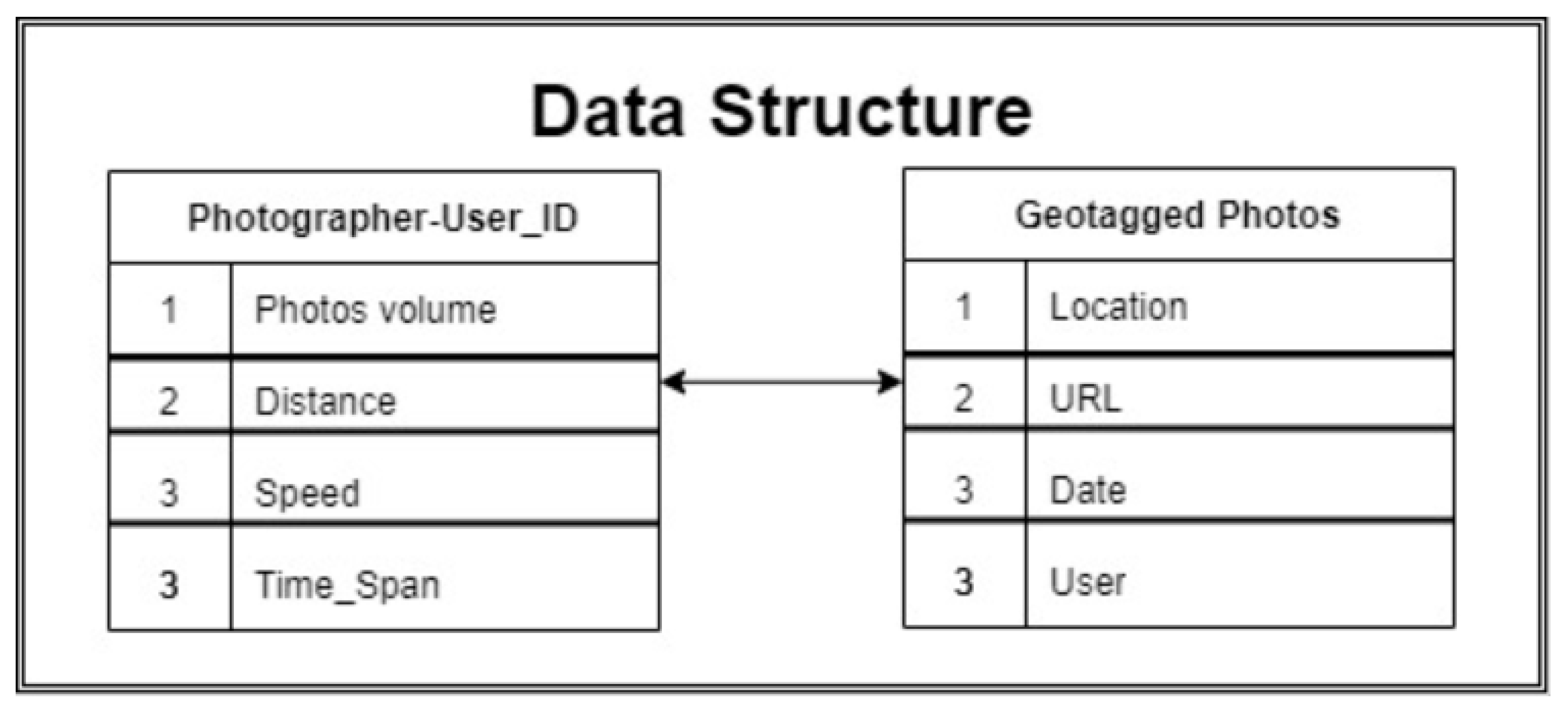
3.1.1. Photo Data
3.1.2. Tourism Photographer
- Trip (visit) duration: the trip duration, possibly covering several days, of a single user i between the first () and the last () geotagged photograph timestamp. The average visit duration tavg among n users is defined in Equation (1).
- Number of photos: tourists will most likely take several photos during their trip. We count the number of photos taken by each user, whereas a threshold of at least three distant photos per user is defined (e.g., [10]) as the minimum number of visited locations that represent a photo-trail.
- Trip distance: the accumulated traveled distance (Du) of a specific user is calculated. A maximum threshold of fifty kilometers is used to ensure the retrieval of walking activity (as opposed to bicycle and public transportation, for example).
- Trip speed: a single trip traveling speed Vu, including multi-day trips, is calculated (Equation (2)) according to the accumulated travelled distance Du divided by the time interval between the last (te) and first (ts) photo timestamp. Outliers larger than 10 km/h are excluded to ensure walking activity only.
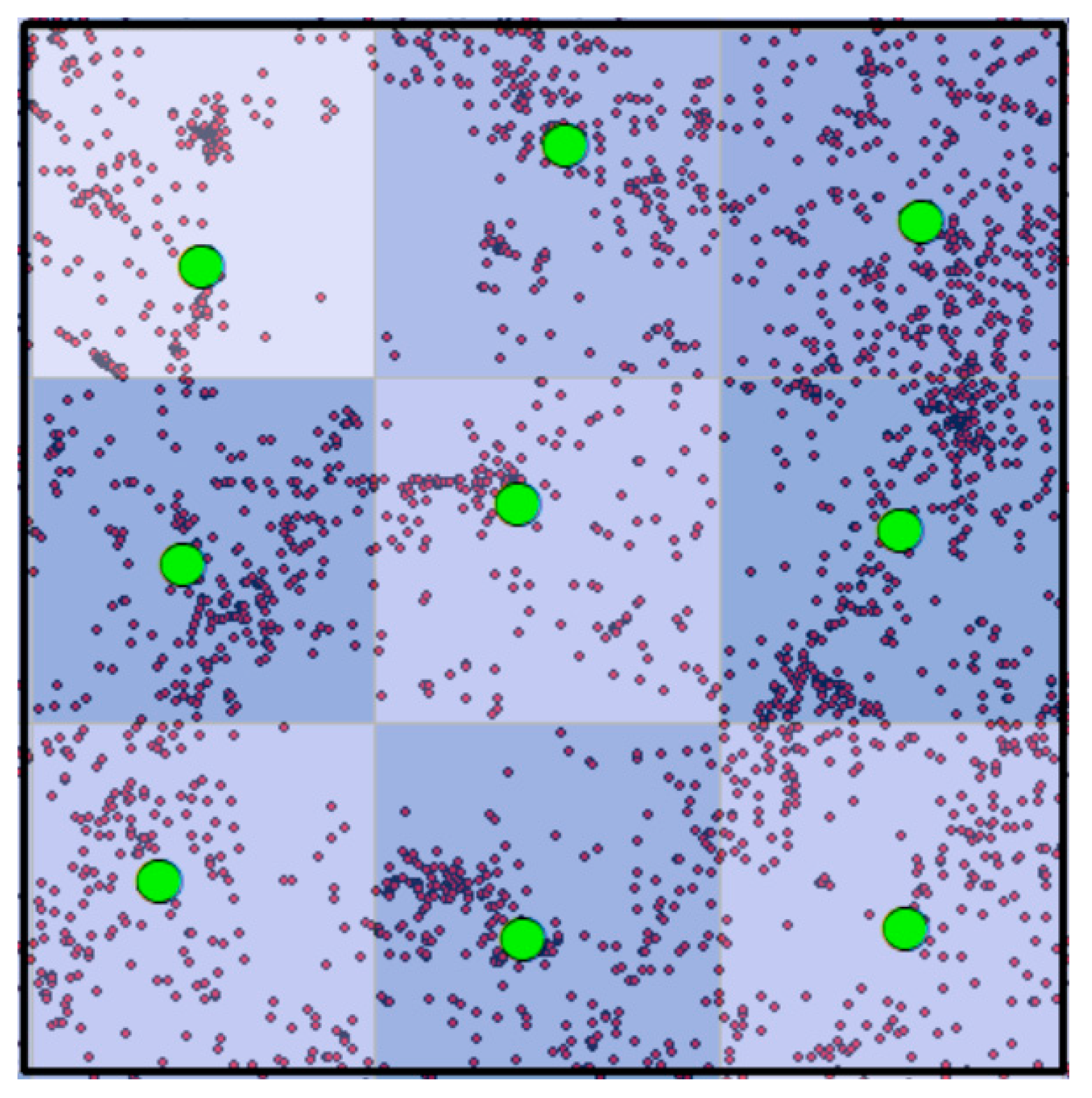
3.1.3. Popular Places Identification
3.1.4. Route calculation
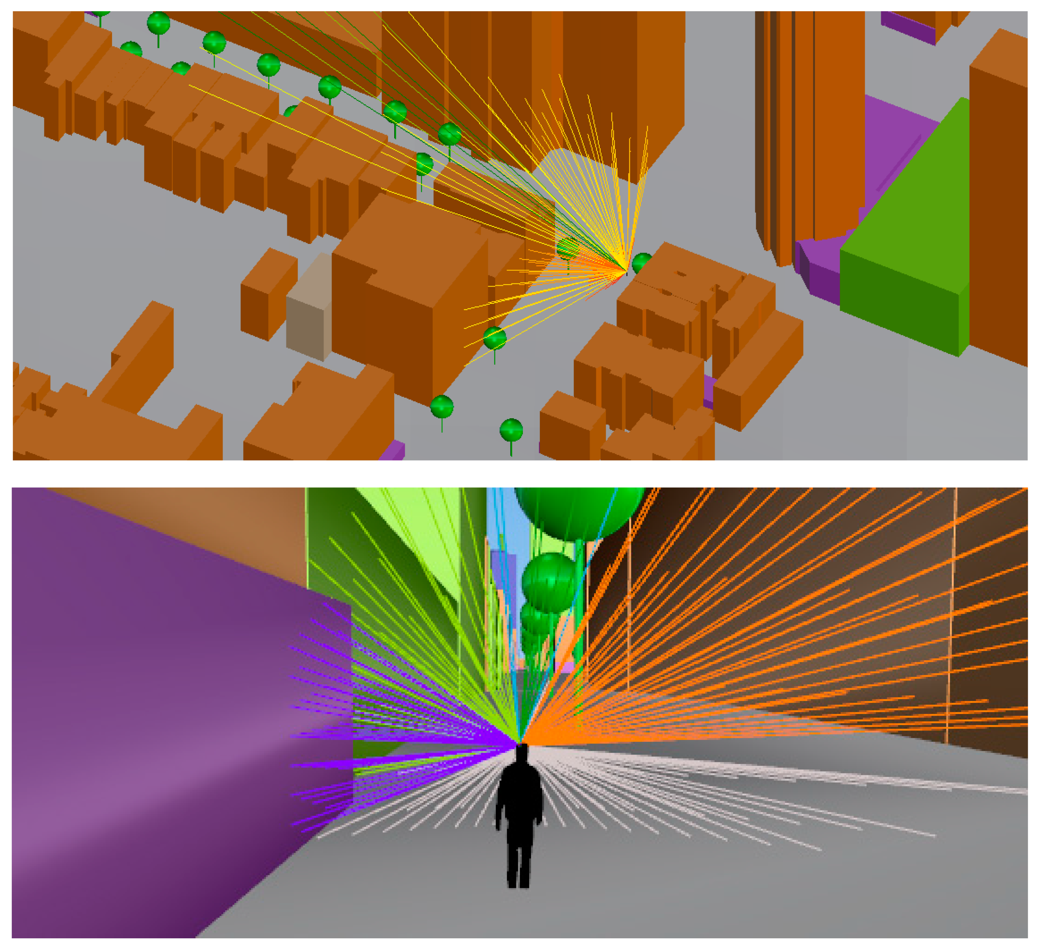
3.2. Visibility Analysis
4. Experimental Analysis
4.1. Tourism Photographers
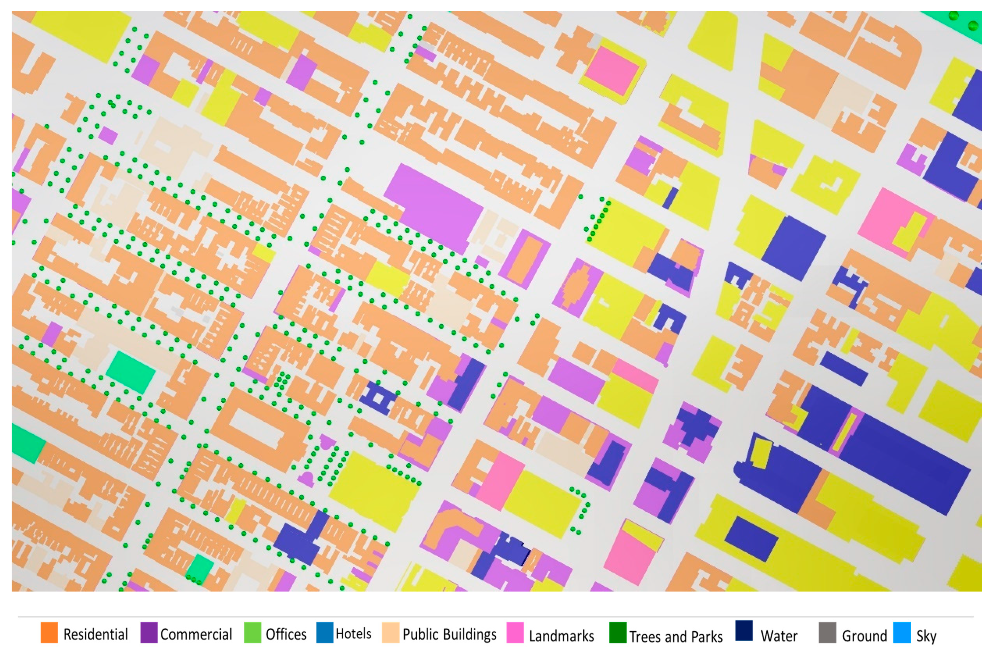
4.2. Popular Places
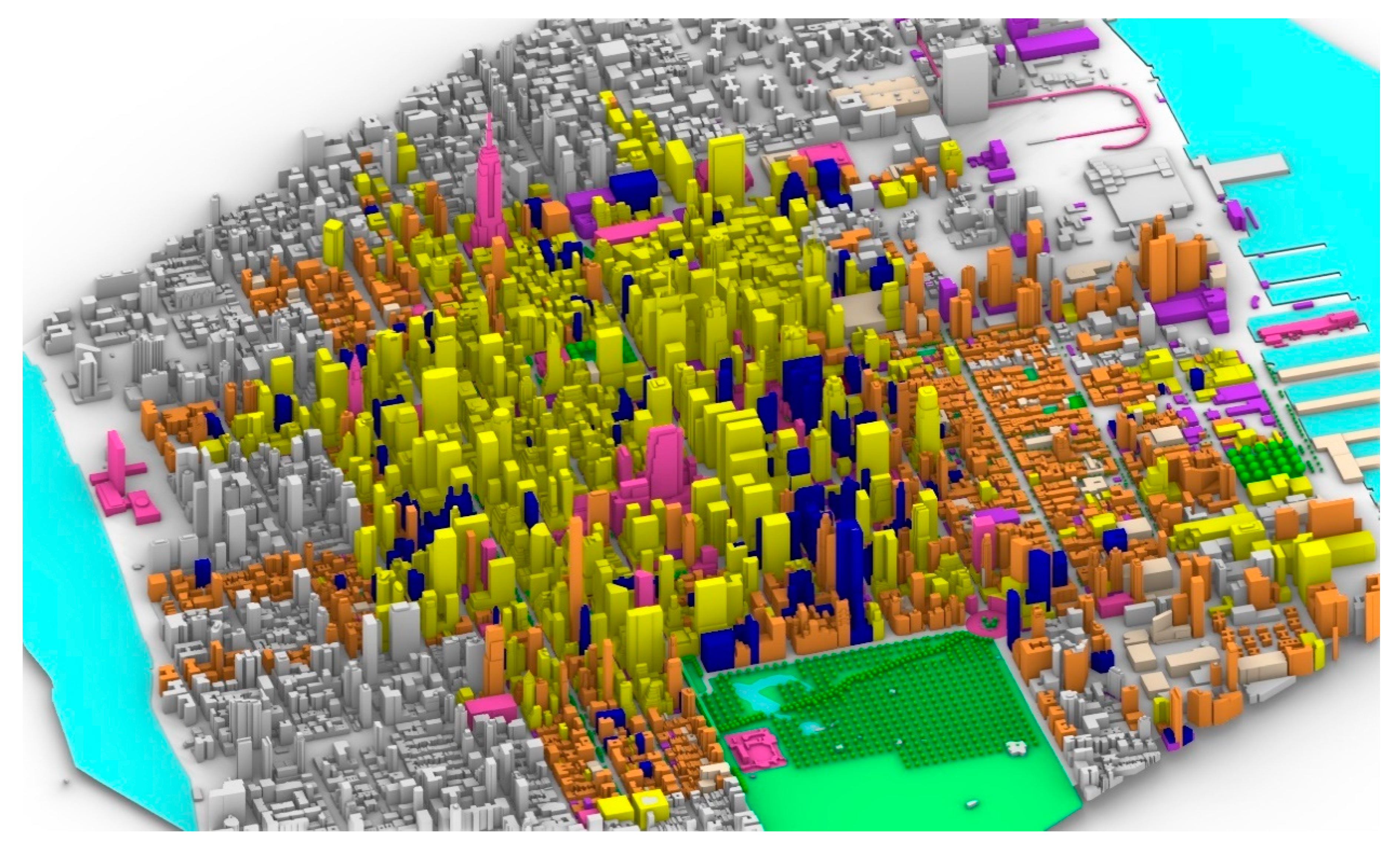
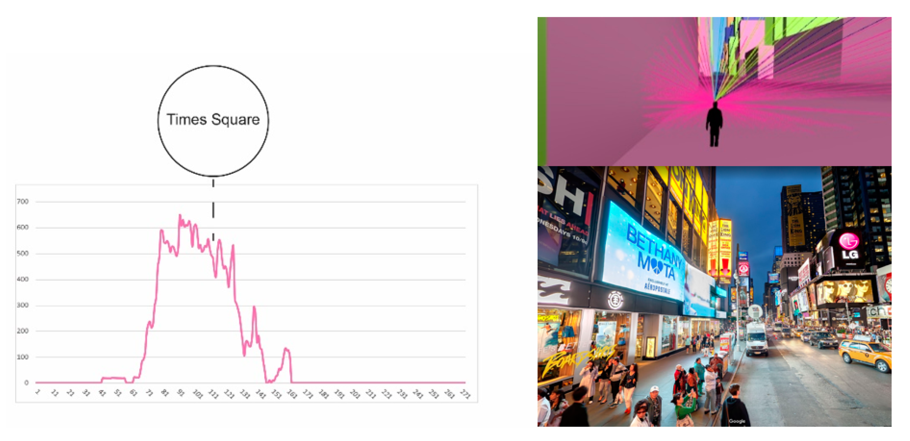
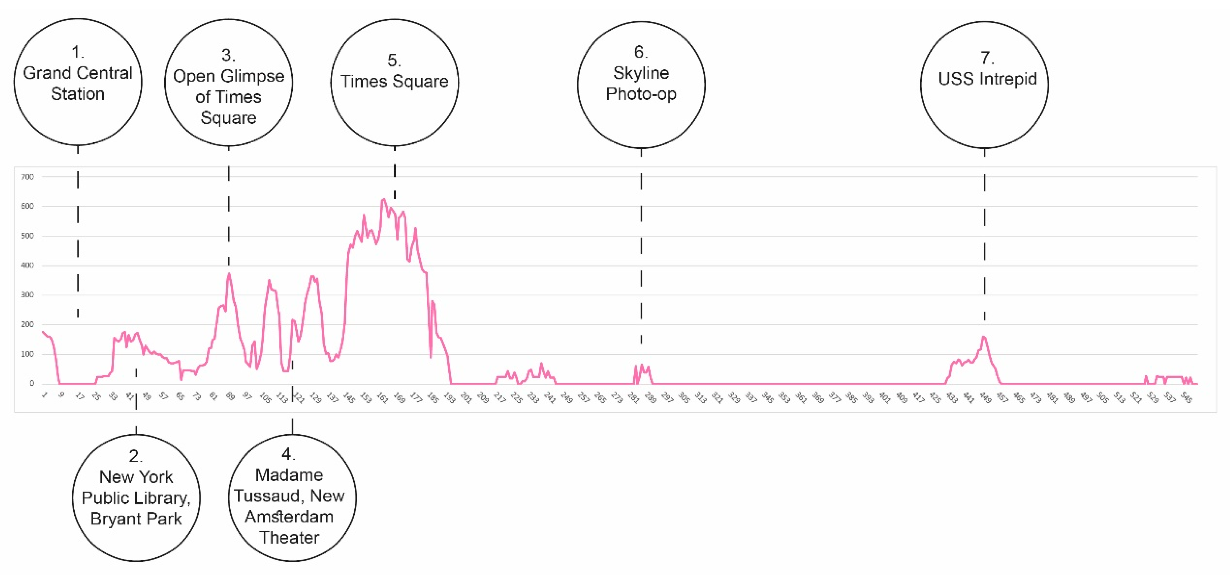
4.3. Case Study I
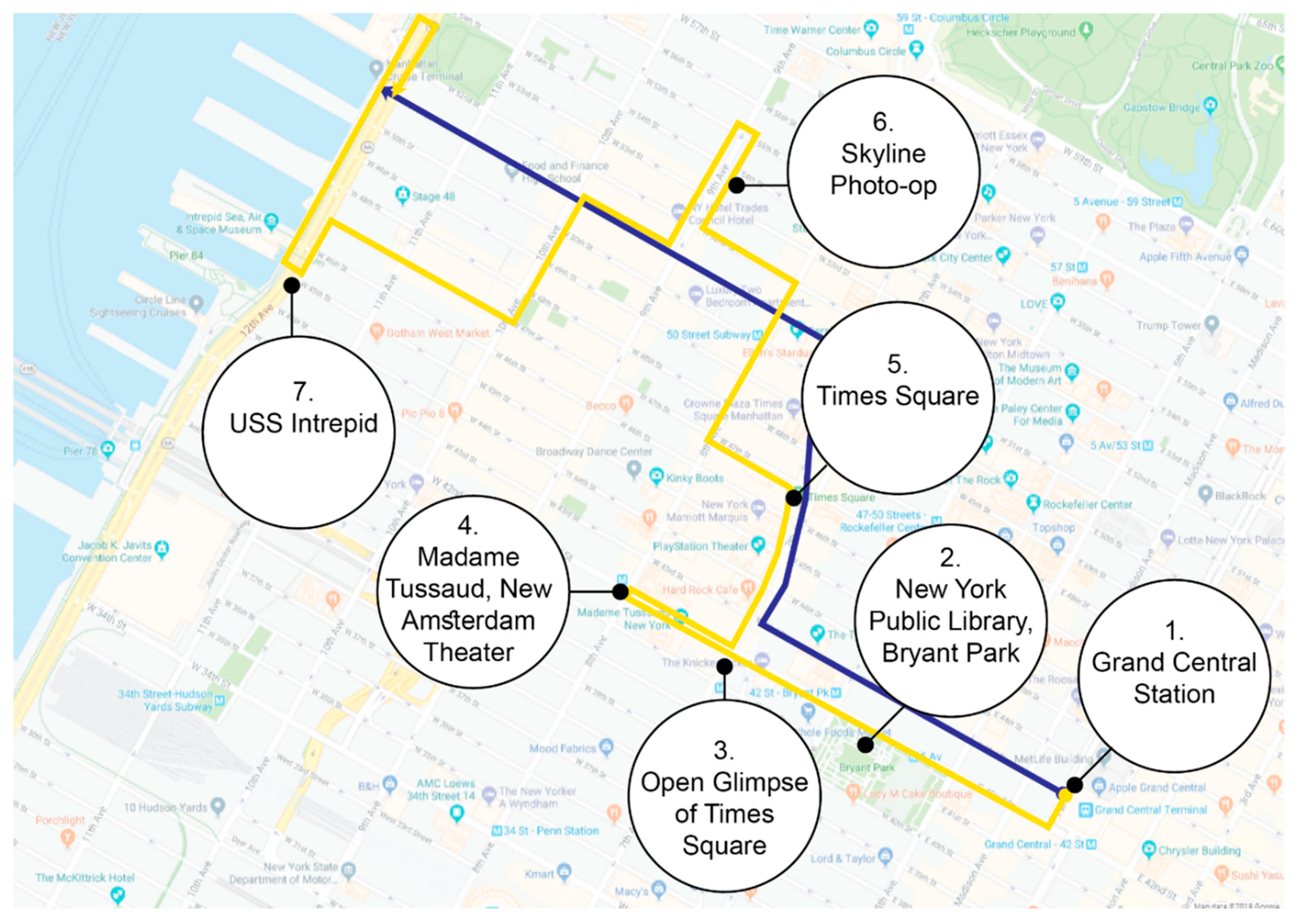
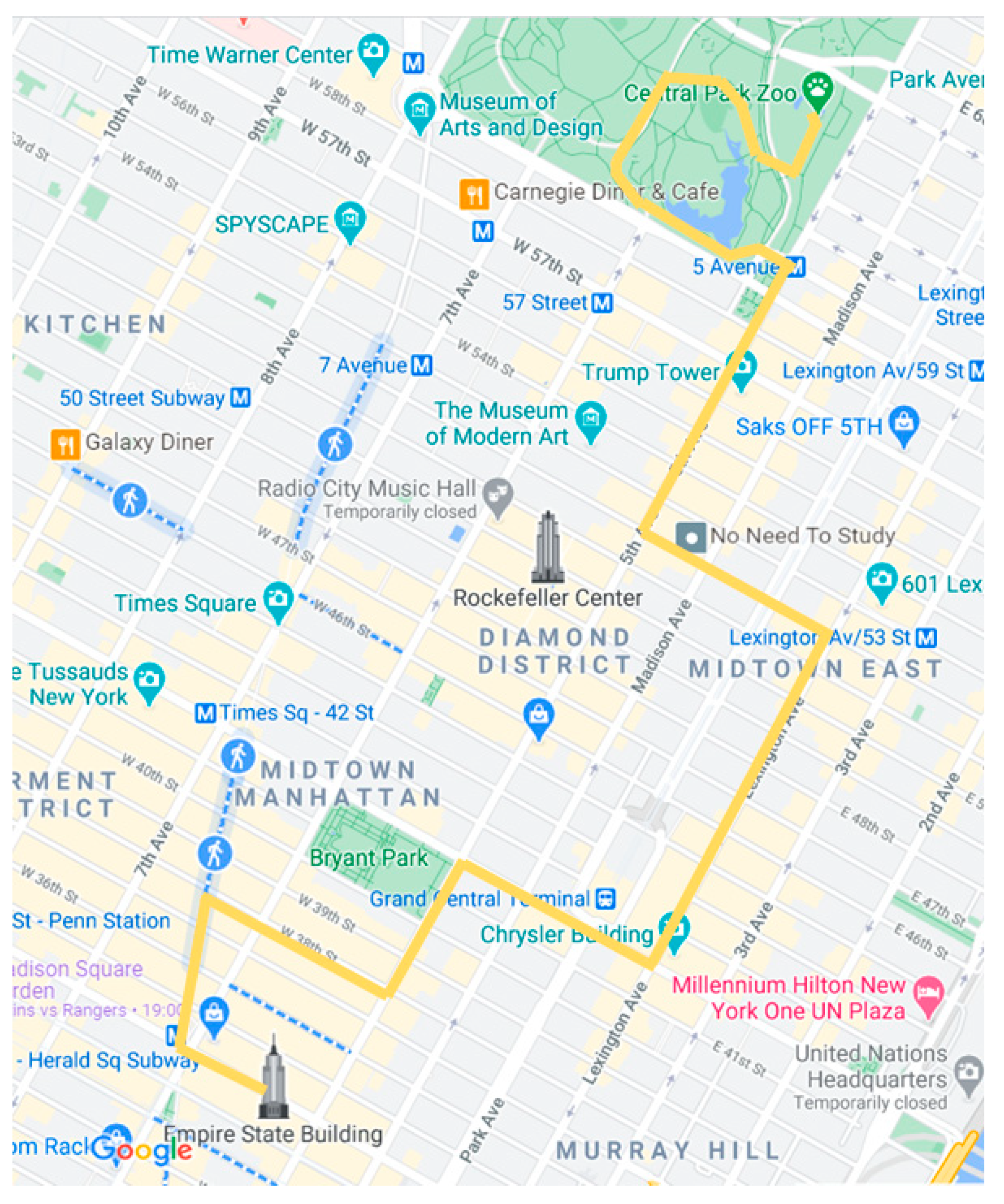
4.3.1. Route Calculation
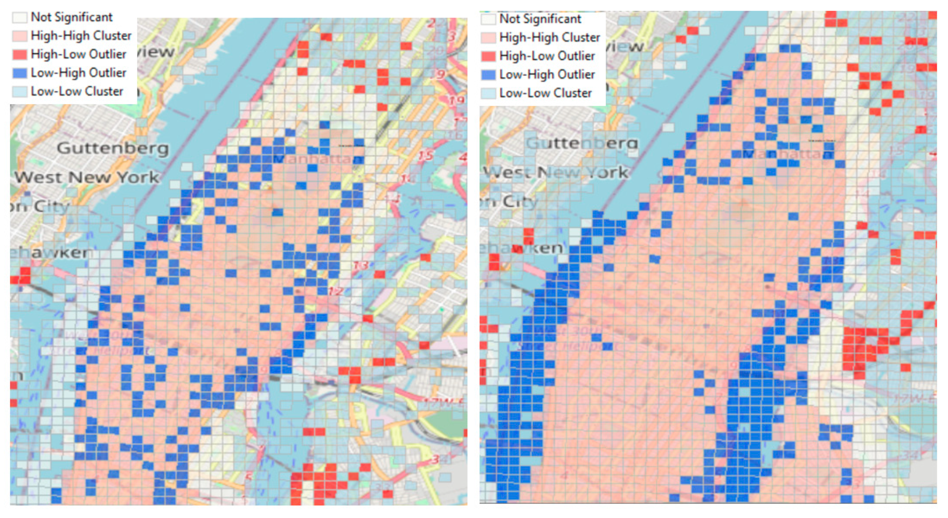
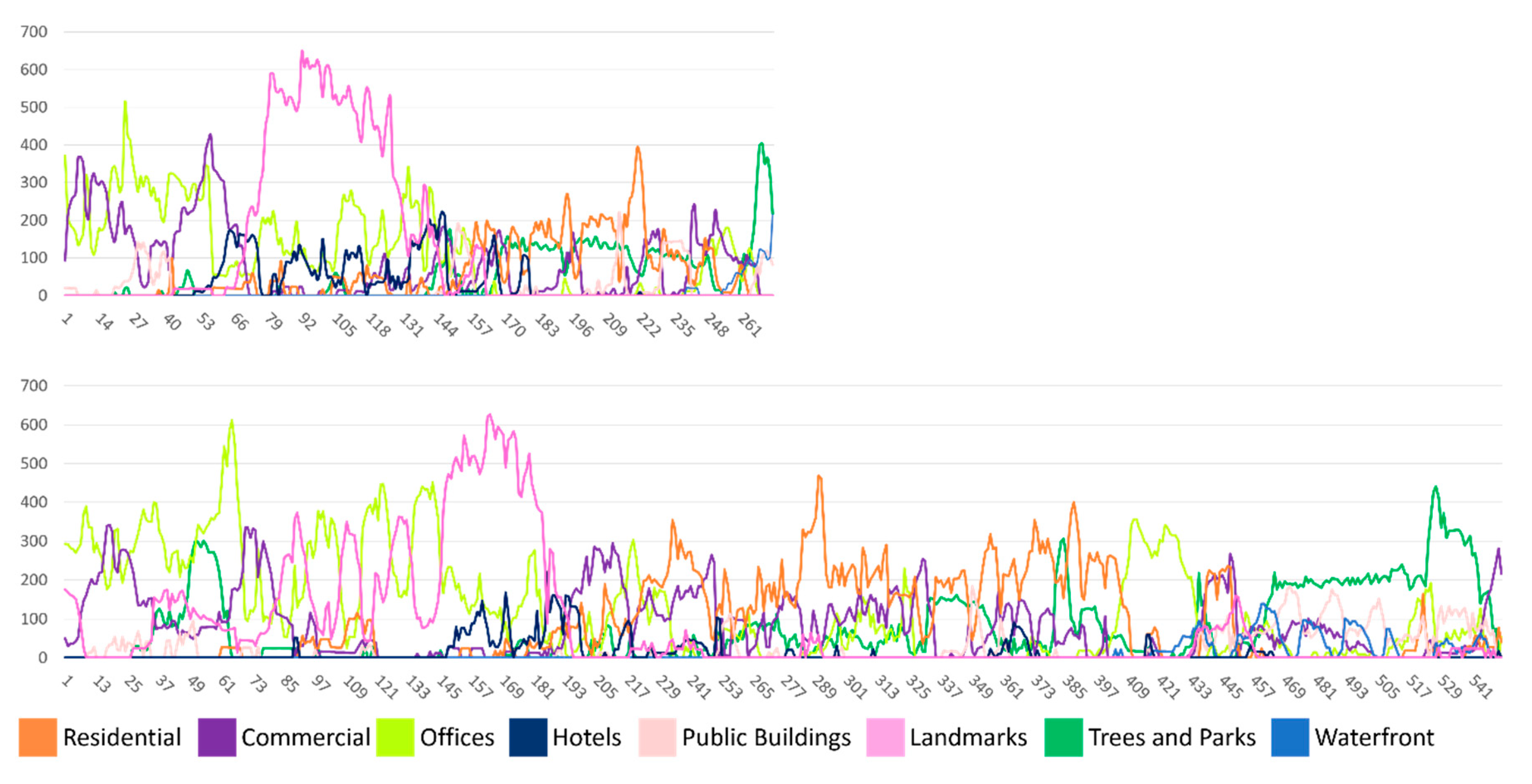
4.3.2. Quantitative 3D Visibility Evaluation
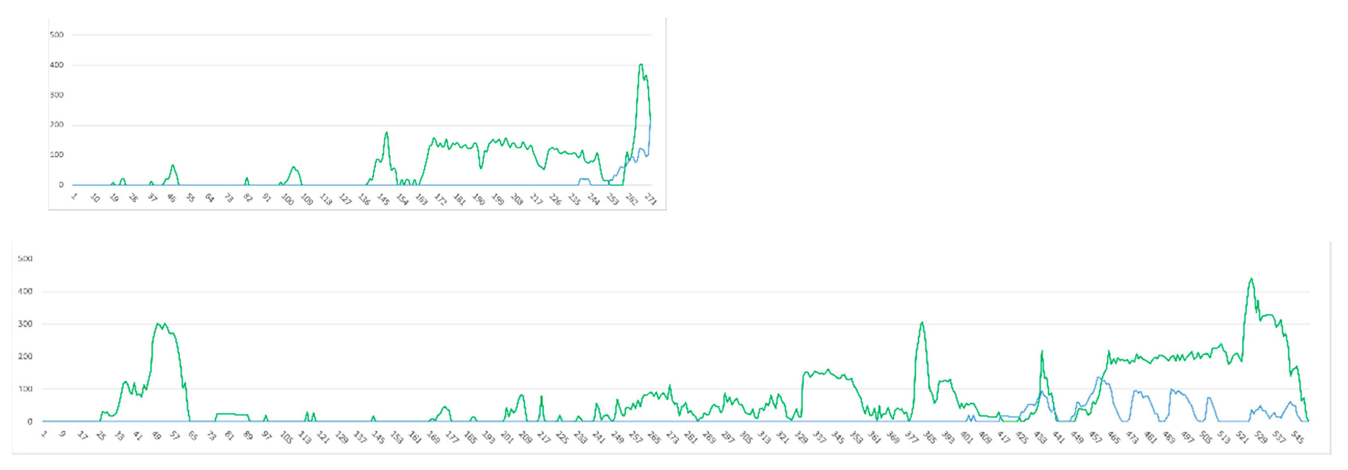
4.4. Case Study II
4.4.1. Route Calculation
4.4.2. Quantitative 3D Visibility Evaluation
5. Discussion and Future Work
Author Contributions
Funding
Institutional Review Board Statement
Informed Consent Statement
Conflicts of Interest
References
- Hu, G.; Shao, J.; Shen, F.; Huang, Z.; Shen, H.T. Unifying multi-source social media data for personalized travel route planning. In Proceedings of the 40th International ACM SIGIR Conference on Research and Development in Information Retrieval, Tokyo, Japan, 7–11 August 2017; pp. 893–896. [Google Scholar]
- Jiang, S.; Qian, X.; Mei, T.; Fu, Y. Personalized travel sequence recommendation on multi-source big social media. IEEE Trans. Big Data 2016, 2, 43–56. [Google Scholar] [CrossRef]
- Robinson, P. Tourism: The Key Concepts; Routledge: London, UK, 2012. [Google Scholar]
- Urry, J. The Tourist Gaze—Leisure and Travel in Contemporary Societies; SAGE publications: London, UK, 1990. [Google Scholar]
- Novack, T.; Wang, Z.; Zipf, A. A system for generating customized pleasant pedestrian routes based on OpenStreetMap data. Sensors 2018, 18, 3794. [Google Scholar] [CrossRef] [PubMed] [Green Version]
- Dembski, F.; Wössner, U.; Letzgus, M.; Ruddat, M.; Yamu, C. Urban digital twins for smart cities and citizens: The case study of Herrenberg, Germany. Sustainability 2020, 12, 2307. [Google Scholar] [CrossRef] [Green Version]
- Aiello, L.M.; Schifanella, R.; Quercia, D.; Aletta, F. Chatty maps: Constructing sound maps of urban areas from social media data. R. Soc. Open Sci. 2016, 3, 150690. [Google Scholar] [CrossRef] [PubMed] [Green Version]
- Samany, N.N. Automatic landmark extraction from geo-tagged social media photos using deep neural network. Cities 2019, 93, 1–12. [Google Scholar] [CrossRef]
- Quercia, D.; Schifanella, R.; Aiello, L.M. The shortest path to happiness: Recommending beautiful, quiet, and happy routes in the city. In Proceedings of the 25th ACM conference on Hypertext and social media, Santiago, Chile, 1–4 September 2014; pp. 116–125. [Google Scholar]
- De Choudhury, M.; Feldman, M.; Amer-Yahia, S.; Golbandi, N.; Lempel, R.; Yu, C. Automatic construction of travel itineraries using social breadcrumbs. In Proceedings of the 21st ACM conference on Hypertext and hypermedia, Toronto, ON, Canada, 13–16 June 2010; pp. 35–44. [Google Scholar]
- Brilhante, I.; Macedo, J.A.; Nardini, F.M.; Perego, R.; Renso, C. Planning sightseeing tours using crowdsensed trajectories. SIGSPATIAL Spec. 2015, 7, 59–66. [Google Scholar] [CrossRef]
- Kádár, B.; Gede, M. Where do tourists go? Visualizing and analysing the spatial distribution of geotagged photography. Cartogr. Int. J. Geogr. Inf. Geovisualization 2013, 48, 78–88. [Google Scholar] [CrossRef]
- Urry, J. Consuming Places; Routledge: London, UK, 2002. [Google Scholar]
- Stylianou-Lambert, T. Tourists with cameras: Reproducing or Producing? Ann. Tour. Res. 2012, 39, 1817–1838. [Google Scholar] [CrossRef]
- MacKay, K.J.; Fesenmaier, D.R. Pictorial element of destination in image formation. Ann. Tour. Res. 1997, 24, 537–565. [Google Scholar] [CrossRef]
- Shoval, N.; Schvimer, Y.; Tamir, M. Real-time measurement of tourists’ objective and subjective emotions in time and space. J. Travel Res. 2018, 57, 3–16. [Google Scholar] [CrossRef]
- Batty, M. Big data, smart cities and city planning. Dialogues Hum. Geogr. 2013, 3, 274–279. [Google Scholar] [CrossRef]
- Keil, J.; Edler, D.; Schmitt, T.; Dickmann, F. Creating immersive virtual environments based on open geospatial data and game engines. KN J. Cart. Geogr. Inf. 2021, 71, 53–65. [Google Scholar] [CrossRef]
- Edler, D.; Husar, A.; Keil, J.; Vetter, M.; Dickmann, F. Virtual reality (VR) and open source software: A workflow for constructing an interactive cartographic VR environment to explore urban landscapes. KN J. Cartogr. Geogr. Inf. 2018, 68, 5–13. [Google Scholar] [CrossRef]
- Fisher-Gewirtzman, D. Can 3D visibility calculations along a path predict the perceived density of participants immersed in a virtual reality environment? In Proceedings of the 11th Space Syntax Symposium, Lisbon, Portugal, 3–7 July 2017; pp. 3–7. [Google Scholar]
- Fisher-Gewirtzman, D. Perception of density by pedestrians on urban paths: An experiment in virtual reality. J. Urban Des. 2018, 24, 1–19. [Google Scholar] [CrossRef]
- Natapov, A.; Fisher-Gewirtzman, D. Visibility of urban activities and pedestrian routes: An experiment in a virtual environment. Comput. Environ. Urban Syst. 2016, 58, 60–70. [Google Scholar] [CrossRef]
- Cooper, C.P. Spatial and temporal patterns of tourist behaviour. Reg. Stud. 1981, 15, 359–371. [Google Scholar] [CrossRef]
- Gavalas, D.; Konstantopoulos, C.; Mastakas, K.; Pantziou, G. Mobile recommender systems in tourism. J. Netw. Comput. Appl. 2014, 39, 319–333. [Google Scholar] [CrossRef]
- Salas-Olmedo, M.H.; Moya-Gómez, B.; García-Palomares, J.C.; Gutiérrez, J. Tourists’ digital footprint in cities: Comparing Big Data sources. Tour. Manag. 2018, 66, 13–25. [Google Scholar] [CrossRef] [Green Version]
- Tchetchik, A.; Fleischer, A.; Shoval, N. Segmentation of visitors to a heritage site using high-resolution time-space data. J. Travel Res. 2009, 48, 216–229. [Google Scholar] [CrossRef]
- Sester, M.; Dalyot, S. Enriching Navigation Instructions to Support The Formation of Mental Maps. In Advances in Spatial Data Handling and Analysis; Springer: Cham, Switzerland, 2015; pp. 15–33. [Google Scholar]
- Borràs, J.; Moreno, A.; Valls, A. Intelligent tourism recommender systems: A survey. Expert Syst. Appl. 2014, 41, 7370–7389. [Google Scholar] [CrossRef]
- Vansteenwegen, P.; Souffriau, W.; Van Oudheusden, D. The orienteering problem: A survey. Eur. J. Oper. Res. 2011, 209, 1–10. [Google Scholar] [CrossRef]
- Lim, K.H.; Chan, J.; Leckie, C.; Karunasekera, S. Towards next generation touring: Personalized group tours. In ICAPS 2016, Proceedings of the 26th International Conference on Automated Planning and Scheduling, London, UK, 12–17 June 2016; The AAAI Press: Palo Alto, CA, USA, 2016; pp. 412–420. [Google Scholar]
- Chen, C.; Chen, X.; Wang, Z.; Wang, Y.; Zhang, D. ScenicPlanner: Planning scenic travel routes leveraging heterogeneous user-generated digital footprints. Front. Comput. Sci. 2017, 11, 61–74. [Google Scholar] [CrossRef]
- Keler, A.; Mazimpaka, J.D. Safety-aware routing for motorised tourists based on open data and VGI. J. Locat. Based Serv. 2016, 10, 64–77. [Google Scholar] [CrossRef]
- Gionis, A.; Lappas, T.; Pelechrinis, K.; Terzi, E. Customized tour recommendations in urban areas. In Proceedings of the 7th ACM International Conference on Web Search and Data Mining, New York City, NY, USA, 24–28 February 2014; pp. 313–322. [Google Scholar]
- Mor, M.; Dalyot, S. Computing touristic walking routes using geotagged photographs from Flickr. In Proceedings of the 14th International Conference on Location Based Services, Zurich, Switzerland, 16–17 January 2018; pp. 63–68. [Google Scholar]
- Li, J.; Yang, Y.; Liu, W. Exploring personalized travel route using POIs. Int. J. Comput. Theory Eng. 2015, 7, 126. [Google Scholar]
- Sun, Y.; Fan, H.; Bakillah, M.; Zipf, A. Road-based travel recommendation using geo-tagged images. Comput. Environ. Urban Syst. 2015, 53, 110–122. [Google Scholar] [CrossRef]
- Korakakis, M.; Mylonas, P.; Spyrou, E. Xenia: A context aware tour recommendation system based on social network metadata information. In Semantic and Social Media Adaptation and Personalization, Proceeding of the 11th International Workshop, Thessaloni-ki, Greece, 20–21 October 2016; IEEE: New York, NY, USA, 2016; pp. 59–64. [Google Scholar]
- Subramaniyaswamy, V.; Vijayakumar, V.; Logesh, R.; Indragandhi, V. Intelligent travel recommendation system by mining attributes from community contributed photos. Procedia Comput. Sci. 2015, 50, 447–455. [Google Scholar] [CrossRef] [Green Version]
- Mor, M.; Dalyot, S. Enriching walking routes with tourism attractions retrieved from crowdsourced user generated data. ISPRS Ann. Photogramm. Remote Sens. Spat. Inf. Sci. 2020, 5, 95–102. [Google Scholar] [CrossRef]
- Kádár, B. Measuring tourist activities in cities using geotagged photography. Tour. Geogr. 2014, 16, 88–104. [Google Scholar] [CrossRef]
- Liu, Q.; Wang, Z.; Ye, X. Comparing mobility patterns between residents and visitors using geo-tagged social media data. Trans. GIS 2018, 22, 1372–1389. [Google Scholar] [CrossRef]
- Becker, M.; Singer, P.; Lemmerich, F.; Hotho, A.; Helic, D.; Strohmaier, M. Photowalking the city: Comparing hypotheses about urban photo trails on Flickr. In SocInfo 2015, Proceedings of the International Conference on Social Informatics, Beijing, China, 9–12 December 2015; Springer: Cham, Switzerland, 2015; pp. 227–244. [Google Scholar]
- Doytsher, Y.; Galon, B.; Kanza, Y. Emotion maps based on geotagged posts in the social media. In Proceedings of the 1st ACM SIGSPATIAL Workshop on Geospatial Humanities, Redondo Beach, CA, USA, 7 November 2017; pp. 39–46. [Google Scholar]
- Zhang, W.; Tan, G.; Lei, M.; Guo, X.; Sun, C. Detecting tourist attractions using geo-tagged photo clustering. Chin. Sociol. Dialogue 2018, 3, 3–16. [Google Scholar] [CrossRef]
- García-Palomares, J.C.; Gutiérrez, J.; Mínguez, C. Identification of tourist hot spots based on social networks: A comparative analysis of European metropolises using photo-sharing services and GIS. Appl. Geogr. 2015, 63, 408–417. [Google Scholar] [CrossRef]
- Gulnerman, A.G.; Karaman, H.; Pekaslan, D.; Bilgi, S. Citizens’ spatial footprint on Twitter—anomaly, trend and bias investigation in Istanbul. ISPRS Int. J. Geo-Inf. 2020, 9, 222. [Google Scholar] [CrossRef] [Green Version]
- Sosko, S.; Dalyot, S. Crowdsourcing user-generated mobile sensor weather data for densifying static geosensor networks. ISPRS Int. J. Geo-Inf. 2017, 6, 61. [Google Scholar] [CrossRef] [Green Version]


| Number of Users | Area (Sq. Km) | Photo Volume | |
|---|---|---|---|
| Manhattan | 22,665 | 14 × 15 | 358,691 |
| Variable | Photos | Photographers |
|---|---|---|
| Moran’s Index | 0.45 | 0.39 |
| Expected Index | 0 | −0.0006 |
| Variance | 0 | 0 |
| Z-score | 252.09 | 117.67 |
| p-value | 0 | 0 |
Publisher’s Note: MDPI stays neutral with regard to jurisdictional claims in published maps and institutional affiliations. |
© 2021 by the authors. Licensee MDPI, Basel, Switzerland. This article is an open access article distributed under the terms and conditions of the Creative Commons Attribution (CC BY) license (https://creativecommons.org/licenses/by/4.0/).
Share and Cite
Mor, M.; Fisher-Gewirtzman, D.; Yosifof, R.; Dalyot, S. 3D Visibility Analysis for Evaluating the Attractiveness of Tourism Routes Computed from Social Media Photos. ISPRS Int. J. Geo-Inf. 2021, 10, 275. https://0-doi-org.brum.beds.ac.uk/10.3390/ijgi10050275
Mor M, Fisher-Gewirtzman D, Yosifof R, Dalyot S. 3D Visibility Analysis for Evaluating the Attractiveness of Tourism Routes Computed from Social Media Photos. ISPRS International Journal of Geo-Information. 2021; 10(5):275. https://0-doi-org.brum.beds.ac.uk/10.3390/ijgi10050275
Chicago/Turabian StyleMor, Matan, Dafna Fisher-Gewirtzman, Roei Yosifof, and Sagi Dalyot. 2021. "3D Visibility Analysis for Evaluating the Attractiveness of Tourism Routes Computed from Social Media Photos" ISPRS International Journal of Geo-Information 10, no. 5: 275. https://0-doi-org.brum.beds.ac.uk/10.3390/ijgi10050275