
The Extension of IFC For Supporting 3D Cadastre LADM Geometry


Faculty of Civil Engineering, University of Belgrade, Bulevar kralja Aleksandra 73, 11000 Belgrade, Serbia
*
Author to whom correspondence should be addressed.
ISPRS Int. J. Geo-Inf. 2021, 10(5), 297; https://0-doi-org.brum.beds.ac.uk/10.3390/ijgi10050297
Submission received: 1 March 2021
/
Revised: 21 April 2021
/
Accepted: 2 May 2021
/
Published: 5 May 2021
(This article belongs to the Special Issue Spatial Data Management in Geosciences, Urban Planning, Land Management, and Cultural Heritage)
Abstract
:The growth of densely populated urban areas has caused traditional cadastral registration systems to face many difficulties in representing complex and multilevel property situations on 2D maps. These challenges, combined with the rapid development of 3D technologies, have forced the research and progress of 3D cadastre systems. The aim of this study is to investigate how a Building Information Model (BIM) can be used as a data source for the Land Administration Domain Model (LADM) based 3D cadastre system, and how that process can be improved. The Industry Foundation Classes (IFC) format and the LADM-based model were selected because both are international open standards that have a significant impact in their own domain. The data sample for the 3D cadastre system was extracted from a BIM model. The paper proposes an IFC format extension which makes it possible to define 3D geometry according to the LADM standard. In order to demonstrate this extension, the West 65 residential and business complex, Belgrade, was selected as a case study. The IFC format extension presented here is a step towards data harmonization between BIM in the IFC format and 3D cadastre systems; it should provide more suitable data in the current IFC schema and enable easy data flow between BIM projects and 3D cadastral data.
1. Introduction
Modern cities are usually densely populated urban areas, with property units located above and below the ground level. This includes property units that are directly on top of each other, thus making complex structures. Since these units are registered and represented in 2D cadastral maps (including land parcels, also represented by boundaries in 2D space) there are many obstacles to overcome. In intensively used areas, for example, there is also a tendency to use space above and under the surface, e.g., constructions on top of each other, infrastructure above/under the ground, an increasing number of cables and pipes, and apartments above shops/offices/other apartments [1]. All of these restrict the registration and presentation of urban property units. In other words, 2D cadastral plans can become ambiguous, and certain complex structures cannot be represented in an unequivocal way. The need to overcome these difficulties, in combination with the development of modern technologies (3D Geoinformation systems, 3D visualization, Building Information Models, etc.), has initiated significant research on 3D cadastres [2,3].
Previous research on 3D cadastres has shown that the technical solutions and data sets they require are more complex than those in traditional 2D cadastral systems [4]. Both the acquisition and the creation of 3D geometry for 3D cadastral purposes is a complex process. Since complex datasets, i.e., 3D objects, are presented in a 3D cadastral system, various data sources are required in order to support the implementation of 3D cadastral systems and to minimize the necessary financial and human resources. Reliable data sources that provide spatial data with high internal quality characteristics [5], such as completeness, logical consistency, positional accuracy, etc., are crucial for achieving high quality and useful 3D cadastral data.
At the same time, the impact of new digital technology (which abounds with data) is becoming more widespread across the construction industry [6] through a relatively new concept: the Building Information Model (BIM). It is understood as the “current expression of digital innovation” in the construction industry [7]. BIM is an integrated and consistent information container, with three-dimensional geometry as its constitutive element [8]. This approach avoids the re-entry of data (an error prone process) and any interruption in the information flow, by providing consistent information content through the lifecycle of a building. A BIM model also represents a comprehensive digital model that encompasses every aspect of a building through its lifecycle [9], thereby resulting in an increase in productivity and quality [6,10] through the improvement of communication and collaboration in a construction project. Furthermore, BIM can provide reliable data sources required for a 3D cadastral system and contribute to the implementation of 3D cadastral systems.
BIM software tools are already available on the market for different disciplines [11,12], and BIM supports collaboration among stakeholders in construction projects [9] with the support of interoperability. Its neutral format provides interoperability between different BIM software tools, as well as different vendors [8]. With this in mind, one of the main goals of the buildingSMART organization is to develop and establish a neutral format for exchange and sharing between the BIM software tools known as the Industry Foundation Classes (IFC) [13]. IFC is vendor-neutral, open, and standardized by the International Organization for Standardization that strives to provide exchange between different disciplines and BIM software tools from different vendors [14]. Thus, IFC is a rich source of data about a facility.
There are several studies that have examined BIM models as a data source in the 3D cadastral domain, covering areas such as querying 3D Cadastral Information from BIM models [15,16], improving building subdivision workflows [17], developing a method to link cadastral information in Land Administration Domain Model (LADM) to 3D models of physical spaces [18], and improving interoperability between BIM and GIS [19]. This indicates that involving BIM in 3D cadastre development has significant potential, and that future research should bring new methods and approaches on how to use BIM data in 3D cadastre systems.
In this study, our research tackles the question of whether the IFC format is a suitable data source for 3D cadastres. More precisely, the objective is to investigate another approach—how a BIM model in IFC format can be directly used as a data source for an LADM-based 3D cadastre system. As the result of the research, we propose an extension of the hierarchical spatial BIM project breakdown to include 3D cadastre geometry, i.e., legal spaces. It means that the IFC extension should contain legal spaces, as defined in the LADM standard. The idea is to improve workflow and data exchange from BIM to 3D cadastre systems. The IFC format and the LADM-based model are selected because both are open and international standards that have a large impact on both domains. IFC is a neutral format and the LADM is widely used as a base for newly-proposed 3D cadastre models. Hence, if there is a functional connection between IFC and LADM standards, it is more likely that such a connection will exist between BIM models and 3D cadastral systems in practice. It is important to emphasize that as-built BIM data is only relevant from the cadastral point of view because the cadastral dataset contains information on built property units, and that is how the BIM data are considered in this research.
The paper proceeds as follows: Section 2 provides a description of a 3D cadastre and defines geometry in the LADM standard, which is used as a base for the proposed 3D cadastral systems; it also presents the BIM model, and introduces the IFC. Section 3 includes an analysis of the existing content of IFC for the purpose of 3D cadastres. It also contains a proposal for an IFC schema extension for more suitable use of the IFC format (as-built model) in the process of registration. Finally, Section 4 contains the case study, and it provides an insight into how to use BIM for the purposes of a 3D cadastre. Moreover, it provides proposals for further research. Section 5 concludes the paper.
2. State of the Art
2.1. 3D Cadastre Geometry
The 3D cadastre was introduced in order to overcome the difficulties of traditional cadastral systems with regard to registering and visualizing complex 3D situations [1,2,20]. There are several ways to introduce 3D geometry into a cadastral system, e.g., through a hybrid or full approach, or by using 3D surfaces or solids. A very comprehensive approach is defined within the LADM standard.
The LADM [21] is a standard of the International Organization for Standardization, and an abstract, conceptual data model that provides a standardized global vocabulary for land administration [22]. It can function as the core of any land administration system, and it facilitates the efficient set up of such systems. Furthermore, it promotes different aspects such as full versioning/history, integration with legal and spatial source documents, a range of 2D and 3D geometry and topology options, unique identifiers, and metadata [23]. The legal aspect of the LADM standard is very important. Paasch et al. [24] proposed a detailed classification of the legal part of the LADM which contains further development of the LADM’s rights, restrictions, and responsibilities (RRR), as well as class and associated code lists.
The LADM was established to create a conceptual model that is independent of technical solutions, and it describes the legal relations. One of the basic features of its standard is that it enables object definition in 3D space [25]. In the context of a 3D cadastre, defining an object in 3D space refers to registering a property with 3D geometry. As proposed by the LADM standard, 3D geometry is presented as a set of 3D surfaces that form a closed body.
The key feature of 3D geometry in cadastral systems is that it represents legal boundaries of the property that do not necessarily match the physical ones. A legal boundary is a boundary marking where one set of rights ends and another begins. For instance, a boundary between two apartments in a cadastral system will be represented as the middle of the wall rather than the edge of the wall. Furthermore, a legal boundary can include extensions around an object that belongs to its legal space. A 3D cadastral system could potentially use both types of geometry, physical boundaries, and legal boundaries. However, legal boundaries are more important. This means that 3D geometry should correspond to the space that defines the 3D legal space of a property, rather than its physical description. The level of measured and registered details for physical boundaries must be further defined by competent authorities.
BIM provides more detailed geometry than what is required for the 3D cadastre. For instance, a BIM project, as opposed to a 3D cadastral system, has greater focus on the reinforcement dimensions, wall thickness, and geometry of the rooms within an apartment. However, the components of BIM geometry must be adapted to the needs of the 3D cadastre, i.e., BIM geometry should include legal boundaries [26]. BIM data needs to be preprocessed before being used in the 3D cadastre, or a BIM model should be extended to include the geometry required by the 3D cadastre.
Although a cadastral system contains legal boundaries, registration can only be carried out after a construction has been built. This means that all previous versions of the project that existed due to its evolution are not interesting from the point of view of the 3D cadastre. Hence, 3D cadastral systems would benefit by extracting 3D geometry from as-built BIM projects, especially for constructions that cannot be easily surveyed, such as those underground.
2.2. BIM and Data Management
A number of BIM definitions are available, and in accordance with the “National BIM Standard–United States (NBIMS-US)”, BIM represents, “a digital representation of physical and functional characteristics of a facility.” This standard highlights three functions of BIM: business processes, digital representation, and organization and control [9]. Another study defines BIM from the aspect of its implementation in industry and the entire market as “a set of interacting technologies, processes and policies” through the lifecycle of a facility [27]. BIM transforms how buildings are designed, constructed, and managed [28]. As a rich source of information, it can support and improve the design and construction [6,29,30], as well as the building operations in the post-occupancy period [31]. Encompassing the building lifecycle, BIM strives to support all relevant aspects of a building. Thus, new research [15,16] has shown how BIM can provide information for 3D cadastres, with many countries expressing an interest in its development.
Furthermore, the construction industry is highly fragmented, involving different disciplines [14], which cause complexities in communication and collaboration in a project. The fundamental idea of BIM is to improve these aspects of the project, in order to create and reuse consistent information by different stakeholders [6] and to provide a shared source of information about a facility from its earliest conception to demolition. Thus, the standardization in the domain of information management supports these fundamental principles of BIM. ISO 19650 is a series of standards in this domain, known in full as the “Organization and digitization of information about buildings and civil engineering works, including building information modelling (BIM).” Parts 1, 2, and 3 from this series cover “information management at a stage of maturity described as building information modelling (BIM) according to the ISO 19650 series” [32,33,34].
Concerning the adoption and utilization of BIM, experts from separate disciplines mostly use the specialized BIM software tools to conduct their own tasks, i.e., to create mono-discipline BIM models. However, a comprehensive BIM model requires harmonization between individual mono-discipline BIM models to become a central multi-discipline BIM model [35]. This process requires numerous information exchanges. To achieve interoperability between those separate mono-discipline BIM models (which actually implies the accomplishment of interoperability between different BIM software tools and different software vendors), a universal and neutral data format, such as the IFC, is needed. The IFC is a format globally adopted for BIM data exchange in the construction industry. However, despite the IFC’s presence in the construction industry, significant efforts still need to be made when implementing and resolving data harmonization and sharing and exchanges of information. This still creates obstacles for fully achieving BIM [14].
In general, the information content of BIM is not standardized, and it depends on a specific purpose. BIM includes three-dimensional geometry and semantics: 3D geometry provides the basis for deriving consistent technical drawings, while at the same time it is the basis for clash detection [36] and consequently collision resolution in the design phase [37]. At the same time, semantics supplies BIM with alphanumeric data to complement the meaning of the objects (physical and non-physical objects). Thus, semantics involves numerous object properties such as mechanical and thermal properties and materials. Further, it involves associations, aggregation and other relationships between objects that are part of the model [14]. As a result, it is possible to perform various analyses, simulations, and advanced controls.
Finally, BIM is an object-based model which contains a rich resource of data about a building. In the current research, the data will be analyzed and selected for registration in the 3D cadastre system.
2.3. The IFC format for BIM
IFC is accepted as an international standard by ISO, designated as ISO 16739-1:2018 “Industry Foundation Classes (IFC) for data sharing in the construction and facility management industries—Part 1: Data schema.” Generally, this is an open standard that covers the BIM data required for exchange and sharing between the BIM software applications that are used in construction projects, or through facility management. The standard includes the relevant data both for buildings, and for the infrastructure [38].
The specified standard for the IFC determines the data schema, which is the base for a consistent and universal file format in the information exchange process, or for data sharing. It is very important to say that the IFC data schema is an open and non-proprietary schema. The IFC schema is based on the EXPRESS language for data specifications that is published in ISO 10303-11 [38]. Hence, the IFC format provides BIM with a consistent approach to data transfer. Thus, certified BIM software applications can translate their own BIM models into this neutral IFC model.
The IFC is a comprehensive classification system for the data relevant to a built facility over its lifecycle [38,39]. The collection and classification of the construction data in IFC started in the 1990s. It was first initiated by a business entity, but very quickly the IFC was taken over by the International Alliance of Compatibility. Nowadays, IFC technical specifications are produced and developed by the buildingSMART organization, and they are publicly available on its website [13]. The buildingSMART organization is engaged in vendor-neutral formats, constantly updating the specifications for software extension add-ons. Newly developing projects in this domain contribute to the constant widening of the IFC specifications. The IFC includes the relevant data to describe a digital building project, the BIM. Thereby, the IFC emphasizes geometry, object properties and relationships.
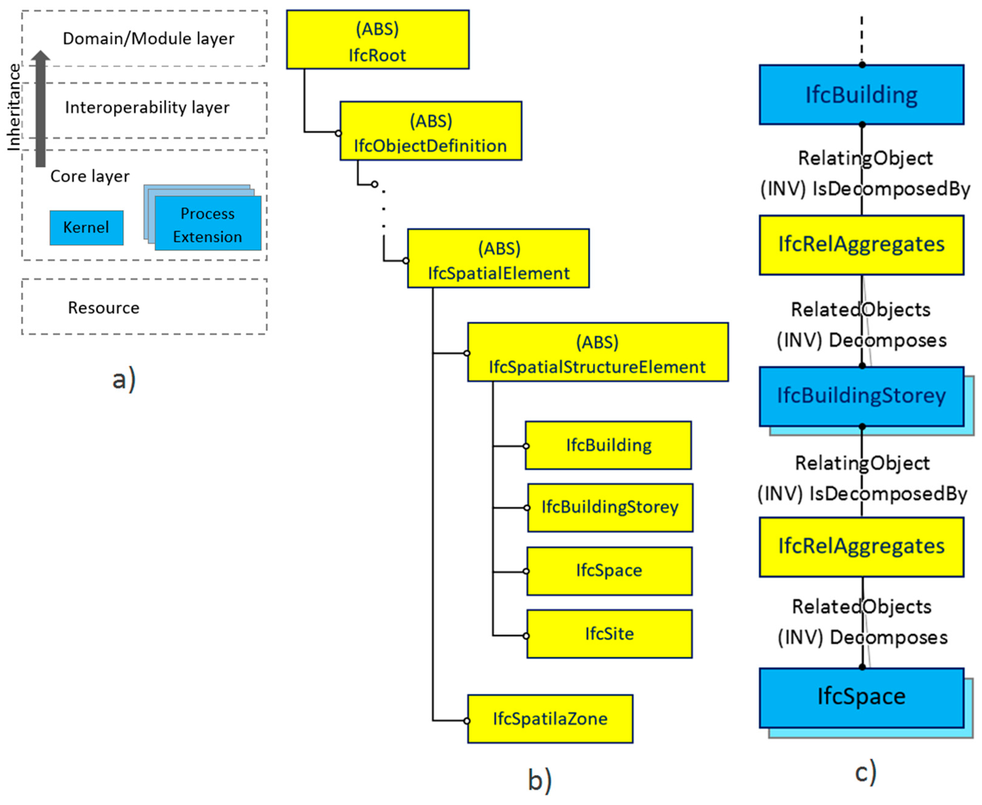
The IFC schema [13,38] is object-oriented, and IFC classes are basic elements of the schema. Furthermore, the classes are grouped in accordance with their function and specialization to form units, named Layers in Figure 1a). Those Layers are hierarchically organized, as is the entire IFC schema. A very important aspect of the schema is inheritance between the IFC classes in this hierarchical organization. An initial root class of the schema is the IfcRoot class (which belongs to the Core layer), which the classes from the upper layers are derived from, except the classes in the Resource layer, whose data are used for referencing from the upper classes (i.e., the classes derived from the IfcRoot). The inheritance from the IfcRoot is divided into three directions: physical and conceptual objects (IfcObjectDefinition), relations between those objects (IfcRelationships), and their properties (IfcProperyDefinition). Basically, this research is directed to the classes that define the spatial data, which are spread over all layers of the IFC schema, in such a way that includes relevant classes for the purpose of the 3D cadastre. Consequently, the exploration of the IFC schema is focused on the subclasses of the abstract superclass IfcSpatialElement, Figure 1b).
3. Methods and Tools
This research tackles the question of whether the IFC format is suitable for 3D cadastre systems based on the LADM standard. An example of such a 3D cadastre system is described by Višnjevac et al. [4]. Hence, this research includes an analysis of the existing IFC classes, which contain definitions of the spatial structure of a building. Thereafter, the proposed extension of the IFC schema is presented, which should provide more suitable data in the current IFC schema, with the aim of ensuring data harmonization between BIM in the IFC format and the 3D cadastre systems. There are also some studies related to the content of IFC that consider the form of the 3D cadastre systems. For instance, the 3D cadastre system in the Netherlands [15], or the 3D cadastre system used in the research of B. Atazadeh et al. [16].
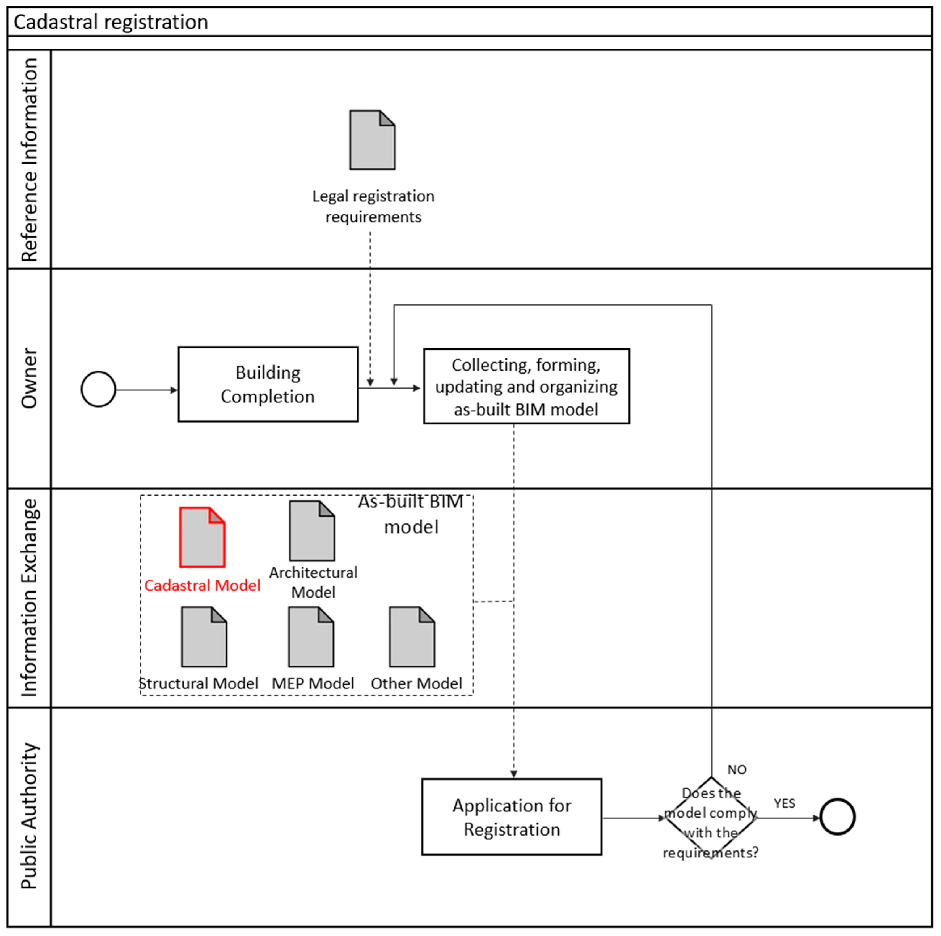
Data harmonization between BIMs in the IFC format and LADM-based 3D cadastre systems should provide effective as-built design handover, shown in the process map in Figure 2. In the observed case, BIM is delivered to the public authority in a neutral format, i.e., IFC. This delivery format is a common recommendation in national BIM standards or guides in countries which have adopted BIM; an example is the “National BIM Standard–United States (NBIMS-US)”. The process map in Figure 2 describes the proposed process of the handover of the as-built BIM model by investors to the competent public authority for registration in a cadastre. Thereby, as-built BIM models in the IFC format need to include a cadastral model which contains data defined by information requirements for the as-built design handover [32]. The public authority participates in this information exchange and makes a decision about registration (decision in a process map).
3.1. Analysis of the Current IFC Schema
It is important to emphasize that the IFC schema [38] provides an opportunity for a spatial breakdown of a building. This breakdown is defined by the subclasses of the IfcSpatialStructureElement (note that it is considered the domain of the IFC schema for buildings, shown in Figure 1b). Those subclasses are a building (IfcBuilding), a building story (IfcBuildingStorey), a space (IfcSpace), and a site (IfcSite). The decomposition of these spatial classes is provided by employing the attribute IsDecomposedBy, which actually provides a spatial breakdown of the building, as well as its constituent and hierarchical lower elements; the decomposition is shown in Figure 1c.
Therefore, the decomposition of a building (in other words, the decomposition of an instance of the IfcBuilding class) results in building stories (the instances of the IfcBuildingStorey class). In the case of a complex building, it results in parts of the building. Then, those parts are also instances of the IfcBuilding class, but with different values from a CompositionType attribute. Thus, this attribute could indicate that a building is a single unit, a part of a building or a complex one. In other words, the IfcBuilding is an aggregation of the building stories or possibly building parts [38].
Further, the decomposition of a building story (the instances of the IfcBuildingStorey class) results in spaces (the instances of the IfcSpace class). Meanwhile, by analogy with the IfcBuilding class, it could potentially decompose into a part of a building story. In that case, that part is an instance of the IfcBuildingStorey class too, and then it has a value of its CompositonType attribute equal to PARTIAL. Thus, IfcBuildingStorey is the aggregation of the spaces or the parts of a story [38].
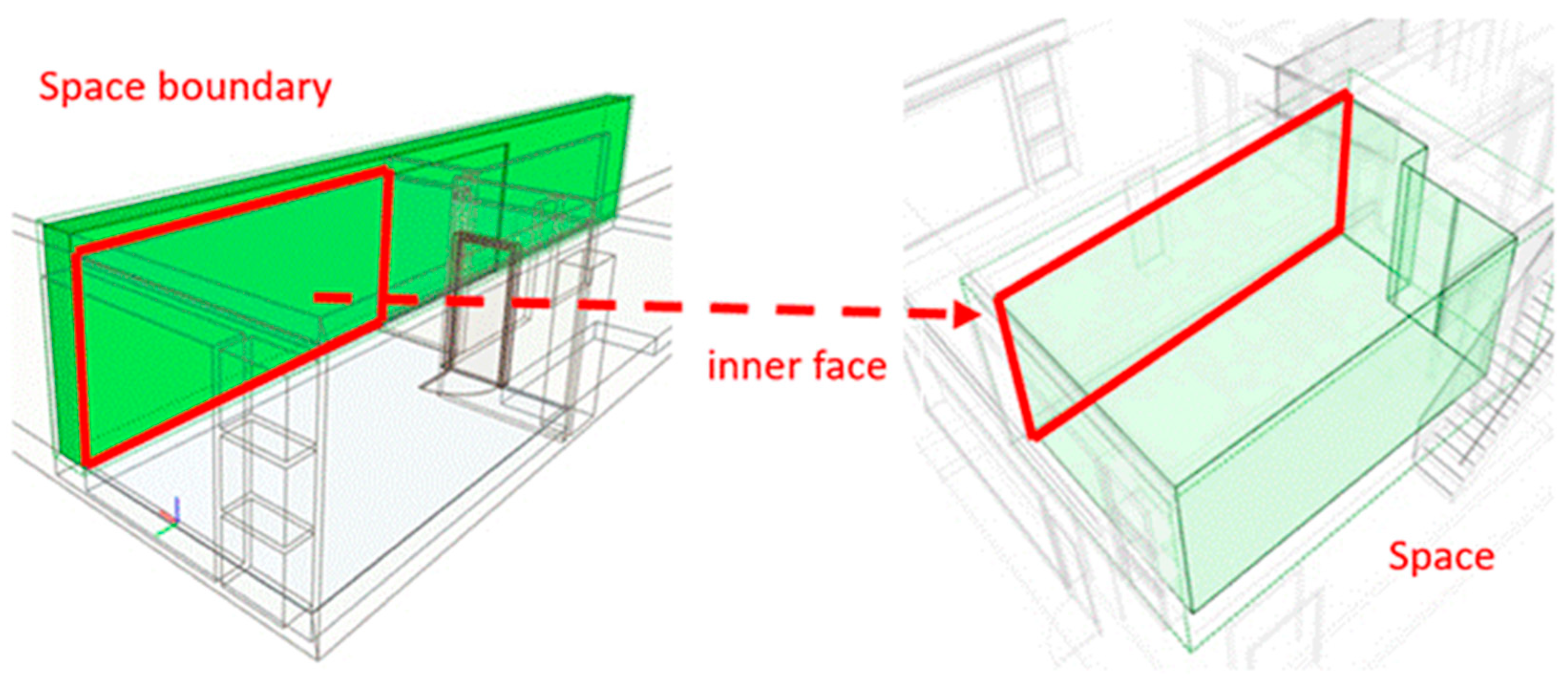
The IfcBuilding and the IfcBuildingStorey represent a container for elements with hierarchical lower spatial elements. The instances of these classes do not possess their own geometric representations during common file export to the IFC format. Their geometry is based on the geometry of their constituent elements. At the same time, the IfcSpace class possesses a geometric representation, and it is bounded by connected building elements and their inner faces, as shown in Figure 3. This is the lowest spatial class in the considered hierarchy. The IfcSpace class defines a functional unit within the building [38].
Finally, very relevant data for 3D cadastres are contained in the geometric representations of elements—the Representation attribute. Those representations are defined by the classes from the IfcGeometryResource (a part of the IFC schema which is contained in the lowest layer of the schema—the Resource layer). The IfcGeometryResource includes the possibilities of the geometric descriptions of the elements using the methods: Constructive Solid Geometry, Boundary representation, and combined methods, as described by C. Eastman et al. [40].
Apart from the highlighted attributes of the IfcBuilding class, other relevant attributes for the 3D cadastre are:
- ElevationOfRefHeight—the reference height represents the altitude 0.00 (above sea level);
- ElevationOfTerrain—the minimal terrain level in elevation;
- BuildingAddress.
A building story contains the Elevation attribute, which represents the height of the base of the story, relative to the 0.00 level (the ElevationOfRefHeight attribute of the IfcBuilding) [38]. The data for those attributes are shown in the next section.
As pointed out at the beginning of this section, all described classes belong to the inheritance from the IfcSpatialStructureElement class. The other direction of inheritance from the superclass IfcSpatialElement is the IfcSpatialZone class (Figure 1b). The IfcSpatialZone class provides the possibility of defining a zone of particular occupancy. This class is a non-hierarchical class and it represents an addition to the hierarchical spatial composition of a project. The class simultaneously provides designations of other zones: a fire safety zone, a construction zone, a lighting zone, a thermal zone, etc. This is achieved by the PredefinedType attribute and its predefined values: primarily OCCUPANCY, then FIRESAFETY, CONSTRUCTION, LIGHTING, THERMAL, etc. [13,35]. Meanwhile, this research highlights the importance of extracting such occupancy zones into a new class, which should become affiliated with the hierarchical spatial breakdown of a building.
3.2. Extension of the IFC Schema
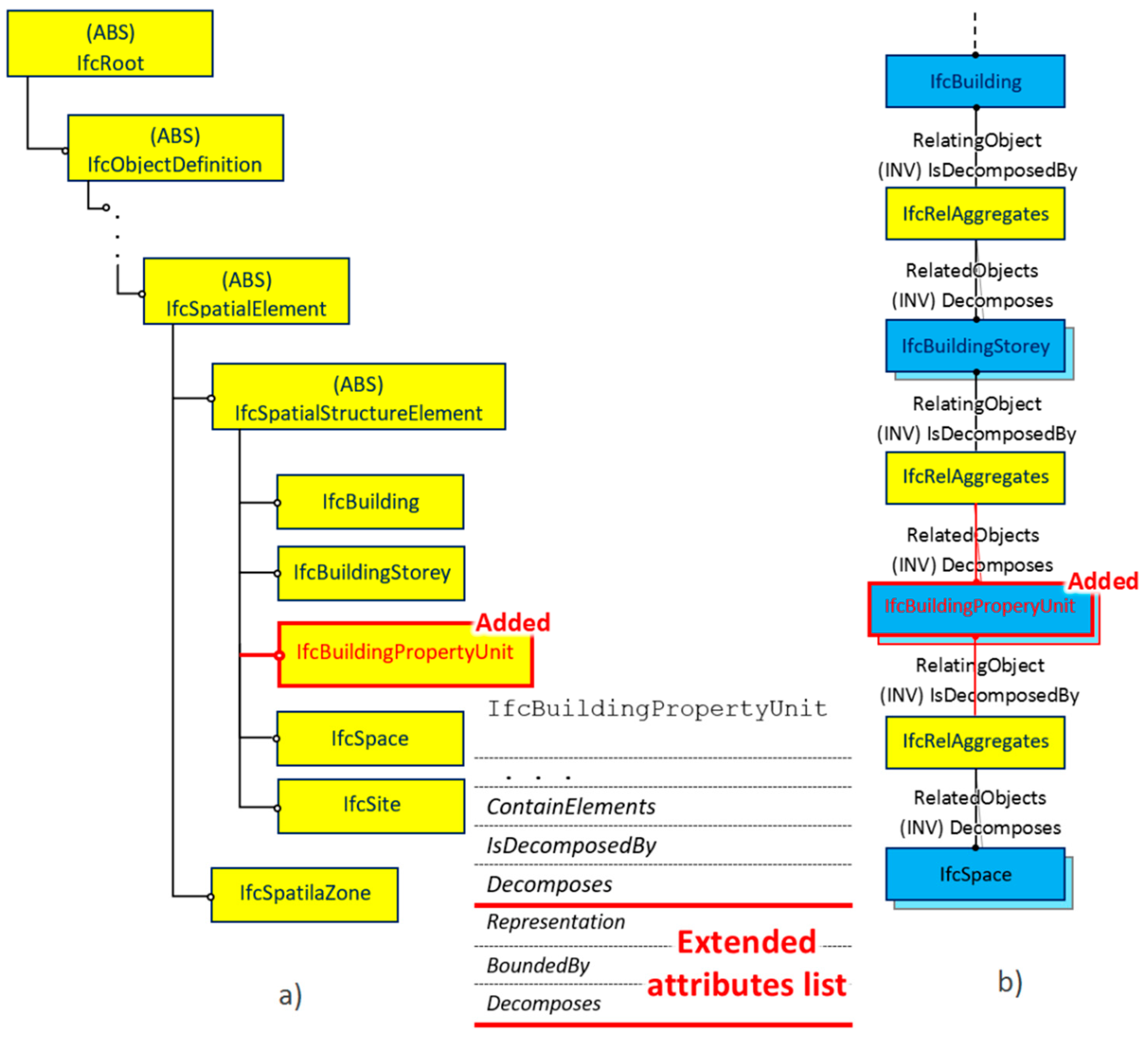
The previous analysis of a spatial breakdown of a building has shown that the story decomposition results directly in functional units—spaces such as rooms and halls. The following facts are considered: (1) multistory buildings are mostly complex cadastral situations; (2) legal spaces possess featured boundaries and there is no overlapping between ownerships, although there might be overlapping between different rights, restrictions, and responsibilities (RRR). This research proposes providing the possibility for the decomposition of a story into legal spaces (such as occupancy units). This is especially important for residential multi-story buildings. The legal spaces could be further decomposed into basic spaces—IfcSpace. Therefore, this research proposes the addition of legal spaces to the hierarchical spatial project breakdown (described in Figure 4). In this way, legal spaces have equivalent definitions from the LADM standard [21]. Below is a proposed extension of the IFC schema [38] for one legal property unit by a new spatial class, tagged as the IfcBuildingPropertyUnit. This class should define a property unit as a non-interrupted space in uniform ownership, like an apartment or a common area. The extended diagrams are shown in Figure 4.
The IfcBuildingPropertyUnit class derives from the IfcSpatialElement class, thereby inheriting all of its attributes. In this inheritance, it is important to highlight the attribute that provides the position in the coordinate system. Its type is IfcLocalPlacement, and it could provide a position relative to the coordinate system of the instances from a hierarchically higher class (a story or a building). In addition, the new class, IfcBuildingPropertyUnit, includes additional attributes: BoundedBy, Representation, and PredefinedType, which are explained below:
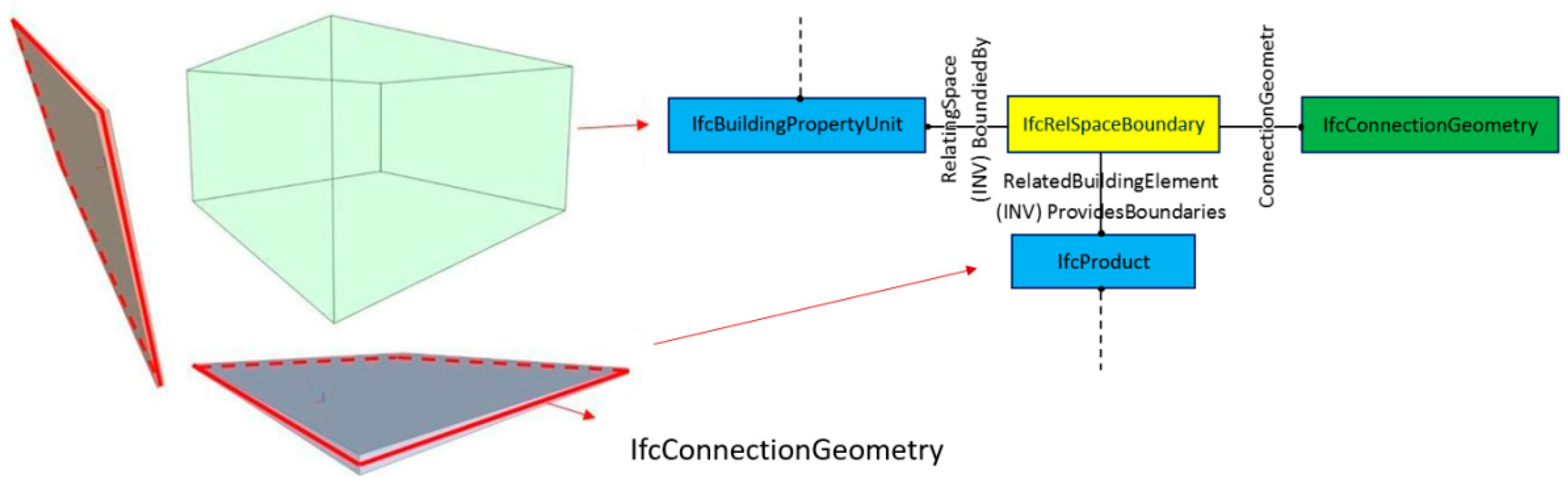
- The BoundedBy attribute provides the legal boundaries of a property unit. In accordance with the IFC schema [13,35], boundaries are defined by physical elements or virtual areas; a relationship between a property unit (an instance of the IfcBuildingPropertyUnit class) and an element (an instance of the IfcElement class) is provided by the IfcRelSpaceBoundary class (Figure 5). IfcConnectionGeometry provides a legal boundary. In the case of an observed cadastral system [4], this IfcConnectionGeometry should point to the middle plane of common boundary elements, with the aim of matching with the legal boundaries (explained in Section 2.1), as shown in Figure 5:
- The Representation attribute should define the geometric representation of the physical spaces of a property unit (in compliance with the cadastral system and the definition of the LADM standard).
- The list of the value of a PredefinedType attribute is assigned according to the current research, proposed in [4]: apartment, common area, offices, garage, storage space, etc.
For other inherited attributes [38]:
- The IsDecomposedBy attribute provides the decomposition of a property unit into basic spaces (the instances of the IfcSpace class).
- The Decomposes attribute defines that a property unit belongs to the story. Additionally, in special cases when an apartment extends on two levels, it belongs to the story that contains its base. Similarly, a common space which usually extends over several levels belongs to the lowest level, the ground floor. This is provided by the relation IfcRelAggregates.
- The ContainElements attribute provides an opportunity for a property unit to include building elements (such as walls) in accordance with the property rights defined in a cadastral system. This refers to building elements and other elements which stretch through the property unit.
4. Implementation and Discussion
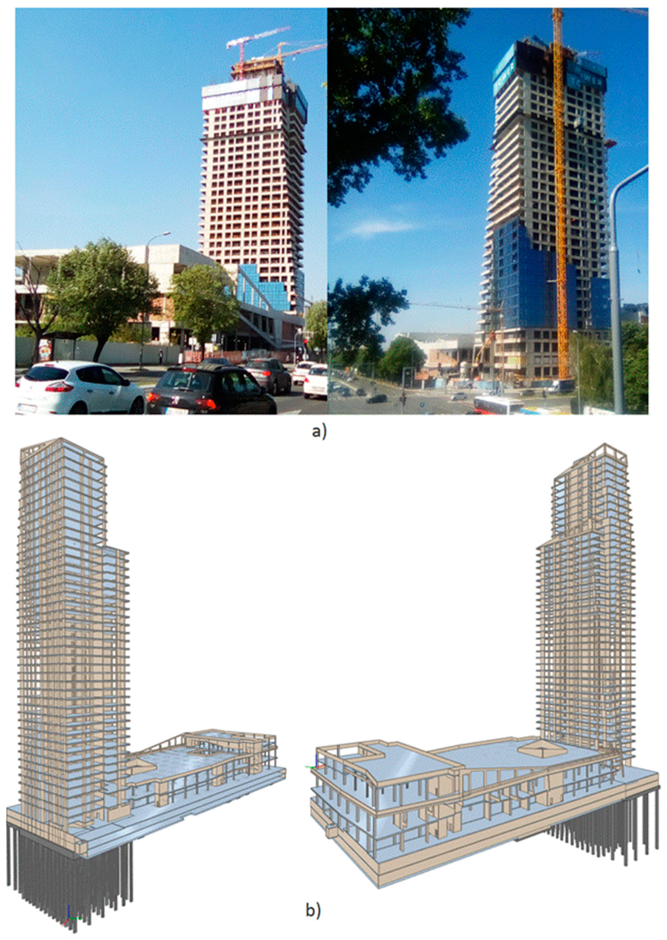
After the analysis and proposed extension of the IFC, the results in this chapter were applied to a case-study project in order to provide 3D geometry for a proposed 3D cadastral system [4]. The West 65 residential and business complex located in Belgrade, Serbia, was selected for the case study. The construction project was prepared in BIM. This modern complex comprises a tall tower for residential and business space, and a shopping mall on two levels. The project is very impressive, and atypical for this region. The tower has forty stories and around 300 residential units. The total height of the tower is around 155 m. Thus, upon completion of the project, it will become the tallest residential building in Serbia. The tower is founded on piles. Underground, this complex is composed of two levels for parking, shared by the shopping mall and the tower. At the moment of conducting this research, the project is under construction (the construction phase of the tower is shown from two perspectives in Figure 6a. The tower is expected to be completed by the summer of 2021.
Due to numerous residential units situated vertically on the forty stories, as well as the underground spaces, the tower represents a complex cadastral situation. Thus, the tower is separated and observed for the purpose of induction in the proposed 3D cadastral system [4].
The project design was prepared in Autodesk Revit 2017. For the purpose of this research, the project was exported into an IFC file using the interface for the IFC export of Revit. Two views of the BIM of this project are shown in Figure 6b, prepared using a freeware IFC model viewer, BIMvision [41].
4.1. Data Extraction from the IFC File of the Case Study
The IFC data presented are related to the tower, i.e., the residential part. They were selected and observed for the process of enrollment exclusively in a proposed 3D cadastral system. Requests for the data are defined in a previous paper [4], which presents the proposal for this 3D cadastral system.
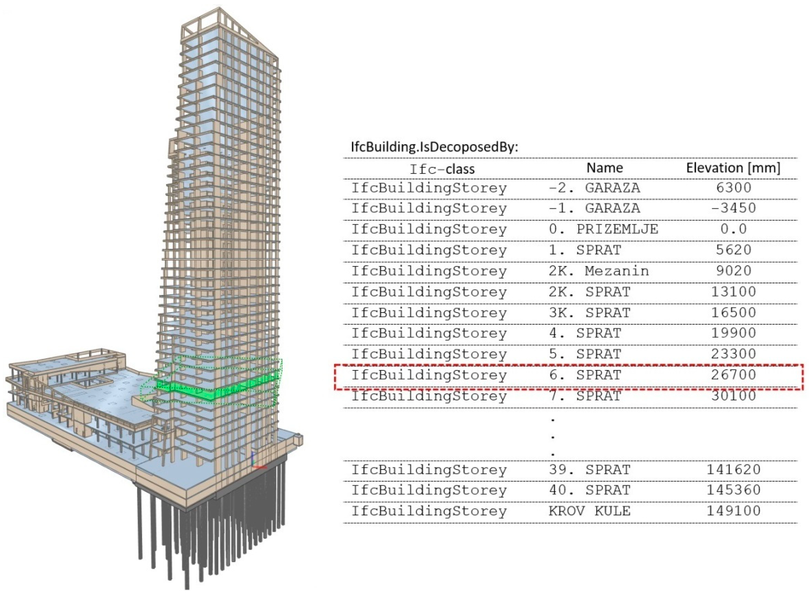
The extracted data relating to the stories, from the IFC file of the tower, are presented in the Table next to Figure 7. The table contains the name and height of the story base (attribute Elevation). The IfcBuildingStorey class represents any level in a building, above or under ground level. Further, the distance between stories is 3.4 m (calculated value). In accordance with the requirements from the research by Višnjevac et al. [4], the highest point of this project is 153.6 m, which can be derived from the elements placed on the highest story. The lowest point of this project is linked to the piles in the foundation at –40 m. With the existence of the IFC extension (the IfcBuildingPropertyUnit class), the total amount of building units could be counted directly. The total number of building stories is derived directly from the IFC data.
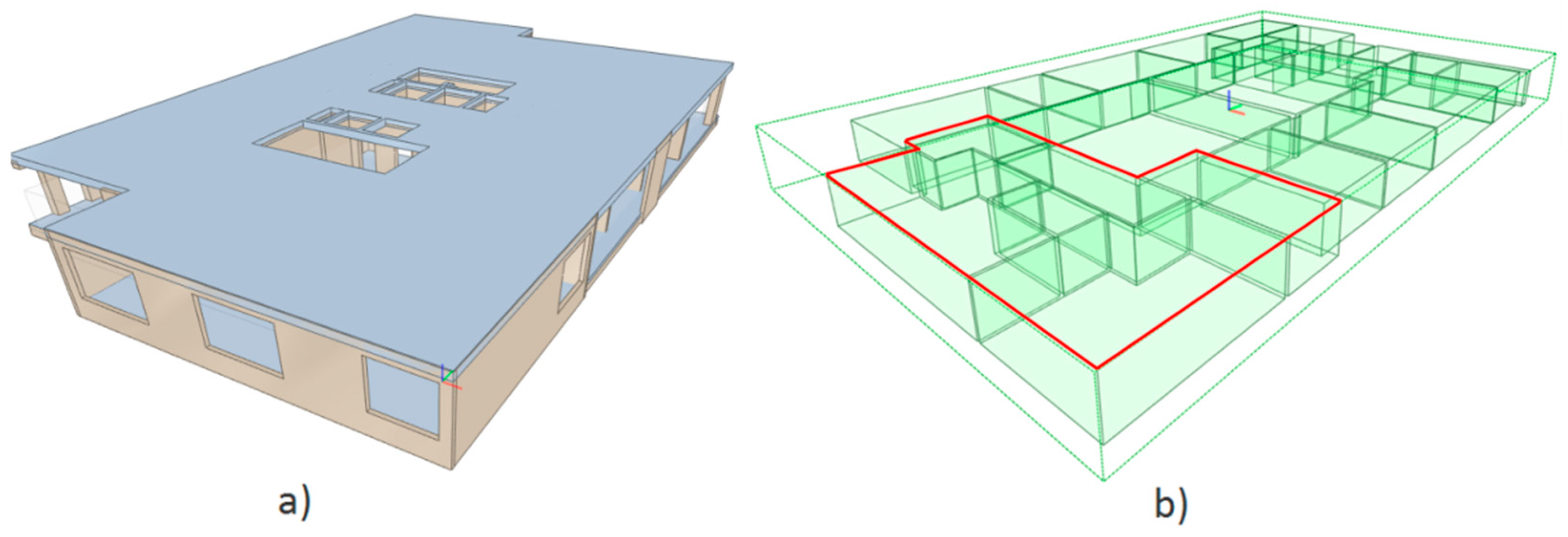
For further analysis, story number 6 (Name: 6. SPRAT) is selected. The values show that the base of the selected story is at a height of 26.7 m. The model of a separated story is shown in Figure 8a, and it is in accordance with the current descriptions for the data in the IFC. This story contains several spaces (the instances of the IfcSpace class), and their visualization is shown in Figure 8b. These are functional units on a certain story, such as rooms and lobbies. These IFC data were exported using the interface for the IFC in Revit and its options, which enable the export of spatial boundaries.
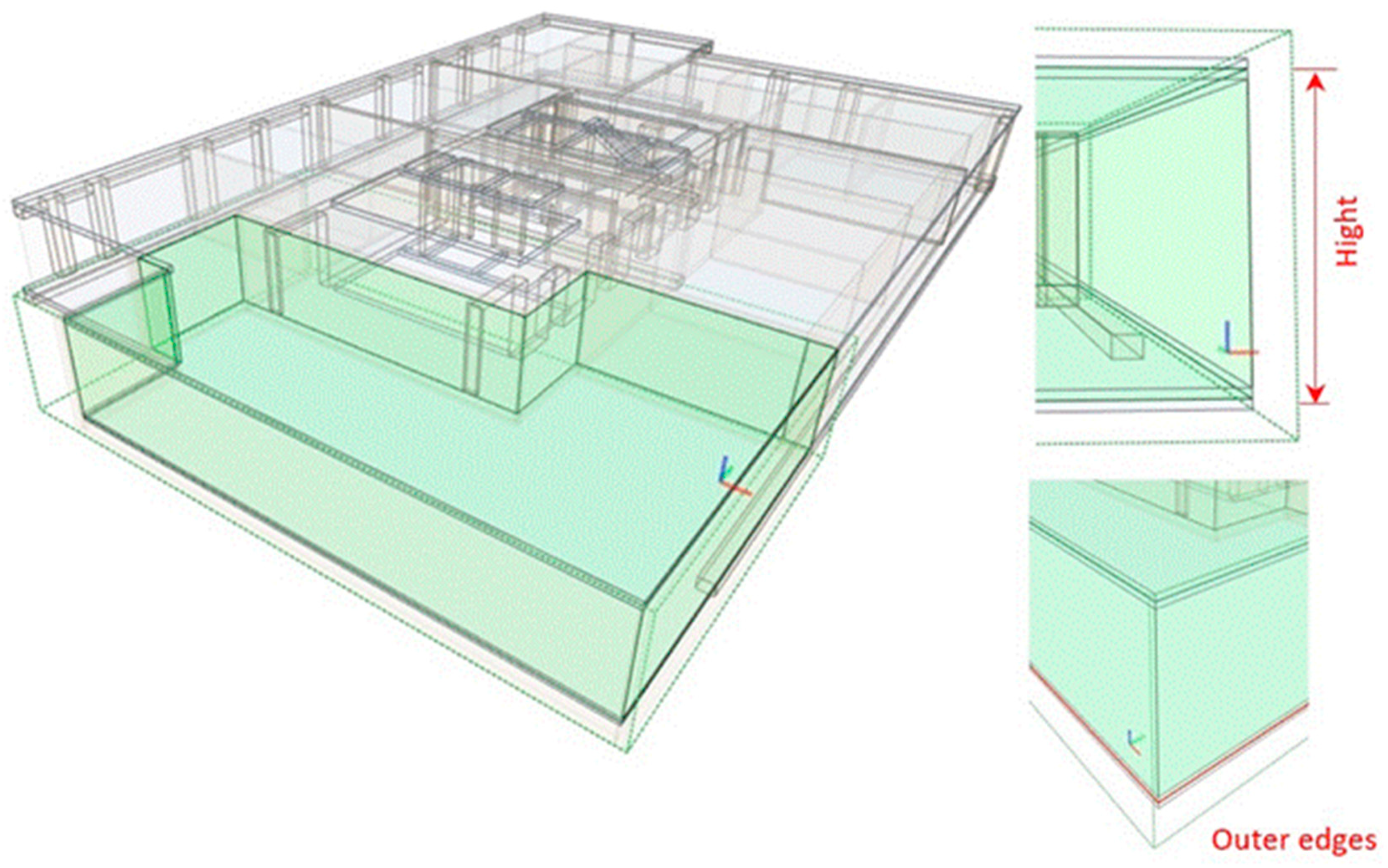
The extraction of separate property units (like apartments or common areas) would be provided by the proposed IfcBuildingPropertyUnit class. One instance of a proposed class is represented in the model in Figure 9. It defines one apartment, located on the sixth story. The model represents the legal boundaries of an observed apartment. This is conducted completely in accordance with the definition for the proposed class, the IfcBuildingPropertyUnit. In the domain of geometry of the legal space, its footprint edges coincide with the outer edges of the outer boundaries or midline inner boundary elements. The height of the representation encompasses the distance between the midlines of the intermediate boundary elements. Thus, the geometric representation of this legal space matches with the 3D geometry of the legal possession limits, which is proposed by Višnjevac et al. [42]. In such a way, the IFC data could automatically provide 3D geometry in the registering process.
4.2. Discussion
The procedure and the example of the case study indicate that the extension of the IFC format should be considered in order to support and simplify the maintenance of modern 3D cadastral systems. Furthermore, the case study and geometry produced show that the BIM model can be extended in order to support legal boundaries, which are important from the 3D cadastral point of view. Additionally, the legal boundaries prepared based on the proposed IFC extensions can be easily exported in a format that will correspond to the LADM 3D geometry definition. The main advantage of an approach that includes the IFC extension to support data needed for a 3D cadastral system is the fact that it ensures easy data flow between BIM projects and 3D cadastral data, making the registration process more efficient.
If the proposed IFC extension becomes standardized, i.e., part of future versions of the IFC standard (after further development and specification), then 3D cadastre support will become an integral part of the standard. This means that any further updates will include the 3D cadastre and be tied to the LADM standard. Further, this is important because IFC is a neutral, open file format specification that is not controlled by a single vendor or group of vendors. Therefore, the proposed extension to the 3D cadastre could potentially be included in many software solutions by different vendors that support the IFC format. This means that using BIM as a data source for the 3D cadastre will be traced through the further development of these standards. It is important that solutions are tied and included in international standards because otherwise they will be less effective or be of only local importance.
The generalization potential of the proposed approach is reflected in the possibility of including the proposed IFC extension as an integral part of the IFC standard. Additionally, the research is based on the LADM standard, and it means that the proposed approach can be used in any country that applies these international standards. Many country-specific aspects will need to be further defined, but this approach will provide a standardized and global view of 3D cadastre data in BIM models.
There are other ways to export 3D cadastre from BIM data, but the benefits of an approach in which the proposed IFC extension is part of future standard versions are significant. For example, a guideline for data extraction could be developed, and it is also a good way of exporting 3D geometry, but that guideline would not be part of the standard. This means that the guidelines need to be changed if the standard is updated. If the proposed IFC extension becomes part of the IFC standard, it will boost the use of BIM data in 3D cadastre more than having a guideline for exporting data. The additional advantage of the proposed IFC extension is that a BIM model would also include the 3D visualization of cadastral data. It means that a user of a BIM model can view 3D objects from all sides and can get additional information, which includes legal boundaries. Legal boundaries, together with all other BIM elements, would provide additional context and make BIM more detailed. Building information models have many aspects, and including relevant classes for the purpose of 3D cadastres, will make them more useful for businesses and government agencies that plan, design, construct, operate, and maintain buildings. This will gain benefits, especially for the planning and maintaining aspects of the BIM lifecycle, because these processes will be improved by including additional information on legal boundaries.
5. Conclusions
This study investigated how the IFC format can be used as a data source for 3D cadastres and proposed changes that enable more fluent data exchange between IFC models and LADM-based 3D cadastral systems. To achieve this aim, an IFC format extension which makes it possible to define 3D geometry, as defined by the LADM standard, was proposed. The data extraction described, which is based on a proposed extension of the IFC schema, presents a comfortable procedure that ensures simple data acquisition for the LADM-based 3D cadastral system. In this way, BIM models can have predefined geometry for 3D cadastres, in the same way as they include various data for different aspects of a building.
Furthermore, it was found that the IFC format is an appropriate data source for 3D cadastre needs. In its current format, IFC can be used as a data source for 3D cadastral systems, but additional data processing is required. With further improvements (the proposed extension), the IFC model can be a consistent and more easily available data source for 3D cadastre systems. The main advantage of the proposed IFC extension is that it enables easy data flow from BIM models to LADM-based 3D cadastral systems and makes the registration of construction easier in a 3D cadastre system. This extension would have a positive influence on establishing and developing 3D cadastre systems by providing support through pre-defined 3D cadastre geometry within BIM models. In addition to all of the benefits achieved by 3D cadastral systems, the proposed extension also improves BIM, making it more detailed and adding data on legal boundaries between building units, which could provide benefits for other BIM uses.
However, further development and specification is required in order to fully support 3D cadastral needs and lead to full implementation. This means that further work and standardization are needed in order to maximize the benefits that the proposed extension could provide. It is necessary to define and implement related classes that will cover special cases in 3D cadastre geometry. For that reason, it is encouraging and promising that the IFC format and the LADM are open and international standards, so future improvements can be expected. This means that software (both for BIM and 3D cadastres) is expected to support formats recommended by the IFC and LADM standards, which will create a strong connection between BIM and 3D cadastral data. At the current stage, this case study can be used as an example of how 3D cadastre data can be extracted from a BIM model.
Author Contributions
Conceptualization M.P., N.V., and B.B.; methodology, M.P. and N.V.; software, M.P.; validation, N.V. and M.P.; formal analysis, B.B.; investigation, M.P. and N.V.; resources, M.P.; data curation, M.P.; writing—original draft preparation, M.P. and N.V.; writing—review and editing, N.V., M.P., N.P., and B.B.; visualization, M.P.; supervision, B.B. and N.P. All authors have read and agreed to the published version of the manuscript.
Funding
This study was supported by the Serbian Ministry of Education, Science and Technological Development, project No. 200092.
Data Availability Statement
The data are not publicly available due to privacy.
Acknowledgments
The authors thank the PFB DESIGN DOO BEOGRAD for providing the case-study project used in this research—the West 65 business complex.
Conflicts of Interest
The authors declare no conflict of interest.
References
- Stoter, J.; Salzmann, M. Towards a 3D cadastre: Where do cadastral needs and technical possibilities meet? Comput. Environ. Urban Syst. 2003, 27, 395–410. [Google Scholar] [CrossRef] [Green Version]
- Van Oosterom, P. Research and development in 3D cadastres. Comput. Environ. Urban Syst. 2013, 40, 1–6. [Google Scholar] [CrossRef]
- Van Oosterom, P.; Dimopoulou, E. Introduction to the Special Issue: Research and Development Progress in 3D Cadastral Systems. ISPRS Int. J. Geo-Inf. 2018, 7, 59. [Google Scholar] [CrossRef] [Green Version]
- Višnjevac, N.; Mihajlović, R.; Šoškić, M.; Cvijetinović, Ž.; Bajat, B. Prototype of the 3D Cadastral System Based on a NoSQL Database and a JavaScript Visualization Application. ISPRS Int. J. Geo-Inf. 2019, 8, 227. [Google Scholar] [CrossRef] [Green Version]
- ISO 19157-1:2013. Geographic Information—Data Quality; International Organization for Standardization: Geneva, Switzerland, 2013. [Google Scholar]
- Mihindu, S.; Arayici, Y. Digital Construction through BIM Systems will Drive the Re-engineering of Construction Business Practices. In Proceedings of the 2008 International Conference Visualisation, London, UK, 9–11 July 2008; pp. 29–34. [Google Scholar]
- Succar, B.; Poirier, E. Lifecycle information transformation and exchange for delivering and managing digital and physical assets. Autom. Constr. 2020, 112, 103090. [Google Scholar] [CrossRef]
- Borrmann, A.; König, M.; Koch, C.; Beetz, J. Building Information Modeling: Why? What? How? In Building Information Modeling; Borrmann, A., König, M., Koch, C., Beetz, J., Eds.; Springer: Cham, Switzerland, 2018. [Google Scholar] [CrossRef]
- National Institute of Building Sciences the United States; National BIM Standard—United States (NBIMS-US). 2015. Available online: www.nationalbimstandard.org (accessed on 15 February 2021).
- Bryde, D.; Broquetas, M.; Volm, J.M. The project benefits of Building Information Modelling (BIM). Int. J. Proj. Manag. 2013, 31, 971–980. [Google Scholar] [CrossRef] [Green Version]
- Autodesk. Autodesk and the BIM Level 2 Mandate. 2016. Available online: https://thebuildingcoder.typepad.com/files/autodesk_and_uk_bim_level_2_mandate.pdf (accessed on 20 November 2020).
- Bentley Systems. Building Studio Uses Bentley Software to Deliver Exceptional, Large-scale Projects. OpenBuildings Designer Ensures Design Quality while Maximizing Productivity. 2019. Available online: https://prod-bentleycdn.azureedge.net/-/media/files/documents/case-studies/cs_building_studio_ltr_en_lr.pdf?la=en&modified=20190709194148 (accessed on 12 February 2021).
- Building SMART. Industry Foundation Classes. The Documentation of the IFC4.2 Schema Specification. 2019. Available online: https://standards.buildingsmart.org/IFC/DEV/IFC4_2/FINAL/HTML/ (accessed on 22 January 2021).
- Borrmann, A.; Beetz, J.; Koch, C.; Liebich, T.; Muhic, S. Industry Foundation Classes: A Standardized Data Model for the Vendor-Neutral Exchange of Digital Building Models. In Building Information Modeling; Borrmann, A., König, M., Koch, C., Beetz, J., Eds.; Springer: Cham, Switzerland, 2018. [Google Scholar] [CrossRef]
- Oldfield, J.; Van Oosterom, P.; Beetz, J.; Krijnen, T.F. Working with Open BIM Standards to Source Legal Spaces for a 3D Cadastre. ISPRS Int. J. Geo-Inf. 2017, 6, 351. [Google Scholar] [CrossRef] [Green Version]
- Atazadeh, B.; Rajabifard, A.; Zhang, Y.; Barzegar, M. Querying 3D Cadastral Information from BIM Models. ISPRS Int. J. Geo-Inf. 2019, 8, 329. [Google Scholar] [CrossRef] [Green Version]
- Olfat, H.; Atazadeh, B.; Shojaei, D.; Rajabifard, A. The Feasibility of a BIM-Driven Approach to Support Building Subdivision Workflows—Case Study of Victoria, Australia. ISPRS Int. J. Geo-Inf. 2019, 8, 499. [Google Scholar] [CrossRef] [Green Version]
- Sun, J.; Mi, S.; Olsson, P.-O.; Paulsson, J.; Harrie, L. Utilizing BIM and GIS for Representation and Visualization of 3D Cadastre. ISPRS Int. J. Geo-Inf. 2019, 8, 503. [Google Scholar] [CrossRef] [Green Version]
- Jetlund, K.; Onstein, E.; Huang, L. IFC Schemas in ISO/TC 211 Compliant UML for Improved Interoperability between BIM and GIS. ISPRS Int. J. Geo-Inf. 2020, 9, 278. [Google Scholar] [CrossRef]
- Stoter, J.E. 3D Cadastre. NCG Nederlandse Commissie voor Geodesie The Netherlands Geodetic Commission, July 2004. Available online: https://ncgeo.nl/downloads/57Stoter.pdf (accessed on 19 November 2020).
- Oosterom, P.V.; Lemmen, C.; Uitermark, H. ISO 19152: 2012, Land Administration Domain Model published by ISO; ISO: Geneva, Switzerland, 2013. [Google Scholar]
- Lemmen, C.; van Oosterom, P.; Bennett, R. The Land Administration Domain Model. Land Use Policy 2015, 49, 535–545. [Google Scholar] [CrossRef] [Green Version]
- Van Oosterom, P.; Lemmen, C. The Land Administration Domain Model (LADM): Motivation, standardisation, application and further development. Land Use Policy 2015, 49, 527–534. [Google Scholar] [CrossRef]
- Paasch, J.M.; Van Oosterom, P.; Lemmen, C.; Paulsson, J. Further modelling of LADM’s rights, restrictions and responsibilities (RRRs). Land Use Policy 2015, 49, 680–689. [Google Scholar] [CrossRef]
- Lemmen, C.; van Oosterom, P.; Thompson, R.J.; Hespanha, J.; Uitermark, H. The Modelling of Spatial Units (Parcels) in the Land Administration Domain Model (LADM). In Proceedings of the XXIV FIG International Congress, Sydney, Australia, 11–16 April 2010. [Google Scholar]
- Oldfield, J.; Van Oosterom, P.; Quak, W.; Van Der Veen, J.; Beetz, J. Can data from BIMs be used as input for a 3D Cadastre. In 5th International FIG 3D Cadastre Workshop; International Federation of Surveyors (FIG): Copenhagen, Denmark, 2016; pp. 199–214. [Google Scholar]
- Succar, B. Building information modelling framework: A research and delivery foundation for industry stakeholders. Autom. Constr. 2009, 18, 357–375. [Google Scholar] [CrossRef]
- Bortoluzzi, B.; Efremov, I.; Medina, C.; Sobieraj, D.; McArthur, J. Automating the creation of building information models for existing buildings. Autom. Constr. 2019, 105, 102838. [Google Scholar] [CrossRef]
- Ghaffarianhoseini, A.; Tookey, J.; Ghaffarianhoseini, A.; Naismith, N.; Azhar, S.; Efimova, O.; Raahemifar, K. Building Information Modelling (BIM) uptake: Clear benefits, understanding its implementation, risks and challenges. Renew. Sustain. Energy Rev. 2017, 75, 1046–1053. [Google Scholar] [CrossRef]
- Barlish, K.; Sullivan, K. How to measure the benefits of BIM—A case study approach. Autom. Constr. 2012, 24, 149–159. [Google Scholar] [CrossRef] [Green Version]
- McArthur, J. A Building Information Management (BIM) Framework and Supporting Case Study for Existing Building Operations, Maintenance and Sustainability. Procedia Eng. 2015, 118, 1104–1111. [Google Scholar] [CrossRef] [Green Version]
- ISO 19650-1:2018(E). Organization and Digitization of Information about Buildings and Civil Engineering Works, including Building Information Modelling (BIM)—Information Management Using Building Information Modelling—Part 1: Concepts and Principles; International Organization for Standardization: Geneva, Switzerland, 2018. [Google Scholar]
- ISO 19650-1:2018(E). Organization and Digitization of Information about Buildings and Civil Engineering Works, including Building Information Modelling (BIM)—Information Management Using Building Information Modelling—Part 2: Delivery Phase of the Assets; International Organization for Standardization: Geneva, Switzerland, 2018. [Google Scholar]
- ISO 19650-1:2018(E). Organization and Digitization of Information about Buildings and Civil Engineering Works, including Building Information Modelling (BIM)—Information Management Using Building Information Modelling—Part 3: Operational Phase of the Assets; International Organization for Standardization: Geneva, Switzerland, 2018. [Google Scholar]
- Succar, B. Building Information Modelling: Conceptual Constructs and Performance Improvement Tools. Ph.D. Thesis, Faculty of Engineering and Built Environment, School of Architecture and Built Environment, University of Newcastle, Callaghan, NSW, Australia, 2013. [Google Scholar]
- Radke, A.M.; Wallmark, T.; Tseng, M.M. An automated approach for identification and resolution of spatial clashes in building design. In Proceedings of the 2009 IEEE International Conference on Industrial Engineering and Engineering Management, Hong Kong, China, 8–11 December 2009; pp. 2084–2088. [Google Scholar]
- Borrmann, A.; Berkhahn, V. Principles of Geometric Modeling. In Building Information Modeling; Borrmann, A., König, M., Koch, C., Beetz, J., Eds.; Springer: Cham, Switzerland, 2018; pp. 27–41. [Google Scholar]
- ISO 16739-1:2018. Industry Foundation Classes (IFC) for Data Sharing in the Construction and Facility Management Industries—Part 1: Data Schema; International Organization for Standardization: Geneva, Switzerland, 2018. [Google Scholar]
- Liebich, T. IFC 2x Edition 3 Model Implementation Guide. 2009. Available online: www.buildingsmart-tech.org (accessed on 9 February 2021).
- Eastman, C.M.; Eastman, C.; Teicholz, P.; Sacks, R.; Liston, K. BIM Handbook: A Guide to Building Information Modeling for Owners, Managers, Designers, Engineers and Contractors; John Wiley & Sons: Hoboken, NJ, USA, 2011. [Google Scholar]
- BIMVision. Free IFC Model Viewer. Available online: https://bimvision.eu/en/functionality/ (accessed on 29 January 2021).
- Višnjevac, N.; Mihajlović, R.; Šoškić, M.; Cvijetinović, Ž.; Marošan, S.; Bajat, B. Developing Serbian 3D Cadastre System—Challenges and Directions. In Proceedings of the 6th International FIG 3D Cadastre Workshop, Delft, The Netherlands, 2–4 October 2018; pp. 383–405. [Google Scholar]
Figure 1.
(a) A diagram of the IFC layers; (b) A diagram of the inheritance; (c) The decomposition of these spatial classes (adopted from ISO 16739-1 standard).
Figure 1.
(a) A diagram of the IFC layers; (b) A diagram of the inheritance; (c) The decomposition of these spatial classes (adopted from ISO 16739-1 standard).

Figure 2.
Process of handover of the as-built design to a public authority.

Figure 3.
A boundary and representation of an instance of the IfcSpace class.

Figure 4.
(a) The IfcBuildingPropertyUnit in the diagram of inheritance; (b) the IfcBuildingPropertyUnit in the decomposition diagram.
Figure 4.
(a) The IfcBuildingPropertyUnit in the diagram of inheritance; (b) the IfcBuildingPropertyUnit in the decomposition diagram.

Figure 5.
The illustration of the BoundedBy attribute for the new IfcBuildingPropertyUnit class.

Figure 6.
(a) Photo of the construction phase of the West 65 project (b) The model of the construction project.
Figure 6.
(a) Photo of the construction phase of the West 65 project (b) The model of the construction project.

Figure 7.
The containment of the IfcBuilding and selected story.

Figure 8.
(a) BIM model of the 6th story; (b) Representation of spaces contained in the 6th story.

Figure 9.
Representation of the IfcBuildingPropertyUnit.

Publisher’s Note: MDPI stays neutral with regard to jurisdictional claims in published maps and institutional affiliations. |
© 2021 by the authors. Licensee MDPI, Basel, Switzerland. This article is an open access article distributed under the terms and conditions of the Creative Commons Attribution (CC BY) license (https://creativecommons.org/licenses/by/4.0/).
Share and Cite
MDPI and ACS Style
Petronijević, M.; Višnjevac, N.; Praščević, N.; Bajat, B. The Extension of IFC For Supporting 3D Cadastre LADM Geometry. ISPRS Int. J. Geo-Inf. 2021, 10, 297. https://0-doi-org.brum.beds.ac.uk/10.3390/ijgi10050297
AMA Style
Petronijević M, Višnjevac N, Praščević N, Bajat B. The Extension of IFC For Supporting 3D Cadastre LADM Geometry. ISPRS International Journal of Geo-Information. 2021; 10(5):297. https://0-doi-org.brum.beds.ac.uk/10.3390/ijgi10050297
Chicago/Turabian StylePetronijević, Marija, Nenad Višnjevac, Nataša Praščević, and Branislav Bajat. 2021. "The Extension of IFC For Supporting 3D Cadastre LADM Geometry" ISPRS International Journal of Geo-Information 10, no. 5: 297. https://0-doi-org.brum.beds.ac.uk/10.3390/ijgi10050297
Note that from the first issue of 2016, this journal uses article numbers instead of page numbers. See further details here.